Are Cities of Northern Europe at Risk ?
A. Plumier & D. JongmansUniversity of Liege, Belgium
Keywords: seismic, risk, vulnerability, damage
ABSTRACT: A benchmark study on seimic risk has been realised on Liege, Belgium, at the request of the Regional Authority. Its main interest is that it deals with the seismic risk of a city in a low seismicity region. The work involves a hazard study based on the recently defined map of seismicity of Belgium, the definition of the individual vulnerability of buildings, the combination of hazard and vulnerability to define risk and static evaluations of connecting details in non engineered structures. For the evaluation of vulnerability, a simplified screening method has been defined. The main conclusion is that in regions where the Peak Ground Acceleration is higher than 0,1g and the building stock does not possess good structural quality, the seismic risk may be considered high.
1 INTRODUCTION
Though apparently less stringent than others like floods, the earthquake hazard does exist in some parts of Northern Europe, but , because of its character of rare event, it has not been considered yet for usual structures like houses and apartment buildings , so that the seismic risk of cities in low seismicity countries is until now a poorly studied topic.
In Belgium, the Regional Authorities are in charge of developing the protection of the public against hazards of natural or industrial nature. , Recently, remembering of the costs and damages associated with the Liège 1983 earthquake (repair costs 75 million Euro), these Authorities asked a benchmark study on seismic risk on Liege, Belgium. This study is bearing on a 2 x 2 Km area in the centre of the city. Its methodology and results are summarised here.
2 STEPS OF THE RESEARCH
The research required the development of the following steps. 2.1 A hazard study
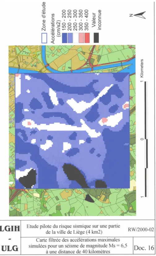
It is based on the recently defined map of seismicity of Belgium, which is part of the National Application Document to Eurocode 8. Two accelerograms at the bedrock level are considered. One corresponds to a MS=5,5 near field event and the other to a MS=6,5 far field event (Rhine graben at 40
Km). For a 475 years return period, the peak ground accelerations defined during the elaboration of the seismic map of Belgium have a PGA= 0,129 g and the accelerograms are normalised to that value. Using a numerical model, the accelerograms and PGA at the foundations level of buildings are established. PGA ranges there between 0.15g and 0.35g. Fig. 1.
2.2 The evaluation of the individual vulnerability of buildings
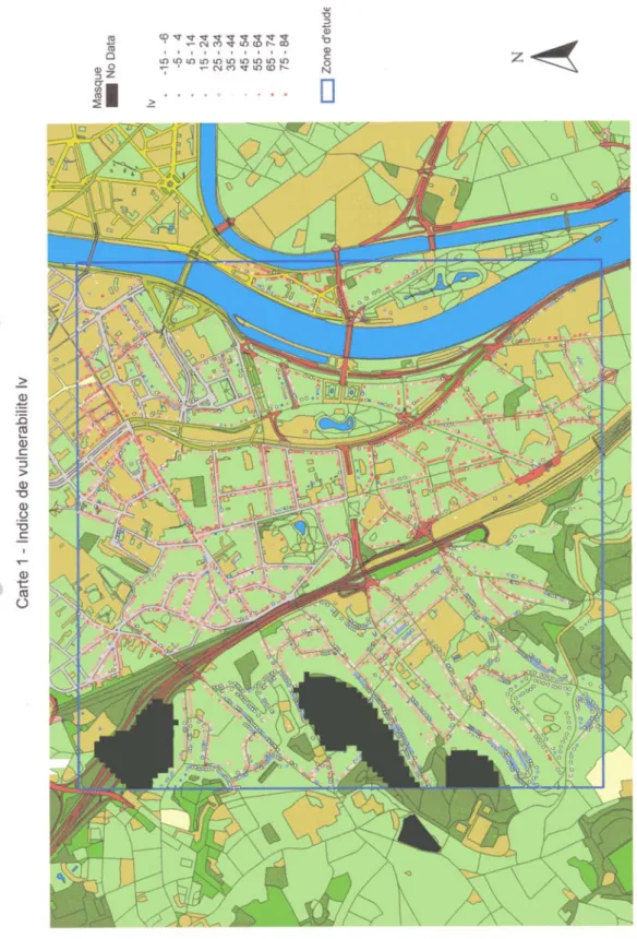
A simplified rapid screening method, inspired by the Catania Project (GNDT, 1998), is defined. It considers 4 typical types of structures which can be found in the study area: masonry houses with wooden floors, masonry houses with concrete floors, multi-storey masonry or concrete-masonry buildings and historical buildings. For each type, a basic value of the vulnerability index Iv is defined.
A numerical value of "modificator" is defined for each typical structural characteristic which influence the vulnerability index, so that the street inquirers are able to compute directly the index of one building by summing up the basic value of the index and the relevant modifications.
An example is given in the following Table for the case of masonry buildings built before 1940, meaning by that date that floors are wooden, thus uneffective diaphragms. Houses with effective floor
diaphragms are characterised by basic values of Iv of 17 and 28, instead of 42 and 52 given in the
Table. The numbers have been calibrated by comparison to the combination with poundering factors used in the Catania project. For the whole group of buildings, Iv ranges between -25 and 100 .
The evaluations made by the street inquirers are reported in the GIS software ARCVIEW .Fig. 2. A building is characterised by its geographical coordinates, the name of the street and the number in the street and by several technical parameters: the structural vulnerability (index Iv), the potential If of
falling objects (chimneys, etc...), the typology (single house, apartment building, etc...) and the risk or damage D.
Table 1.
Masonry house built before 1940 (= type 1)
Basic value of Iv isolated house or between 2 + 42
end of a Seri or corner house + 52
Modifications high % of openings + 5
weakened ground level + 5
heavy balcony, heavy upper wall + 5
slender + 5
irregular + 5
hammering + 5
additional tie beams/ tie bars - 15
2.3 Evaluation of the seismic risk
The risk is expressed as a relative damage D which is the ratio of repair cost to new construction cost. It is computed using the approach defined in the Catania project ( Faccioli et al, 1999), in particular the statistical relationships between PGA, Iv and the damage D. This option may be approximate,
because the statistics behind these relationships are based on post earthquake surveys made on building stocks which do not correspond exactly with the typical constructional practice in the Liège area. However, no other easily applicable option is available. Fig. 3 presents a map of risk.
2.4 Design of connecting details for non engineered structures
Simple static evaluation of the seismic action effects at the connections between floors and walls, walls and walls, roof and walls have been made They have been used to define connection details adapted to the context of a low seismicity country. These details could at low cost modify deeply the vulnerability of structures, as will be explained in the conclusions.
3 CONCLUSIONS
- Uncertainties affect many parameters: the PGA value of the earthquakes considered,
the method of evaluation of the vulnerability index Iv, the relationship between PGA, Iv and the damage D. So the conclusions should be considered as tendencies, not strict numbers.
- Under the 475 years return period earthquake, significant damages would take place.
45% of the buildings would suffer damages such that repairs would cost more than reconstruction. Only 20% of the buildings would have repair costs less than 60% of the new construction costs; only 7% of buildings would have repair cost lower than 40% of the new construction costs - This conclusion is not really surprising, given the seismic action and the building stock
characteristics: many masonry houses with poor diaphragms, apartment buildings with soft storeys, structures weakened by openings at floor levels without structural design, etc.
- The effects of the 1983 Liege earthquake , which was a MS=4,5 to 5 near field event (Plumier et
al, 1985), are coherent with the present evaluation which corresponds to a MS=5,5 near field or
- The spectral accelerations at high frequency, which define PGA, are 10 to 30 % higher than those given in the prEN 1998, present version of Eurocode 8. This may be considered a fair agreement. - Adapted design measures for new non engineered structures, as well as some retrofitting
measures are needed. They can change considerably the vulnerability of structures: the average damage D decreases from 77% to 28% of new construction cost.
- Specific architects education should be developed, as well as structural control for acceptance of new projects and modifications to existing buildings.
- Falling of non structural objects is a public safety issue, as was observed during the Liège 1983 earthquake. Many cars were destroyed, but no people injured, because it was 2 am. Structural checks of non structural appendices are needed, in particular in the city centre.
Acknowledgement.
This research project has been executed at the request and with the support of the Ministry of Land Management of the Région Wallonne of Belgium.
References
FACCIOLI, E., PESSINA, V., CALVI, G.M., BORZI, B. (1999). A study on damage scenarios for residential buildings in Catania city. Journal of Seismology Volume3 N° 3, 1999, 327-343.
GNDT, 1998, Model for the vulnerability evaluation of masonry buildings in the historic centre of Catania based on the LSU rapid screening data, Technical document by the working group Vulnerability of Catania.
PLUMIER, A., VAN GILS, J.M., CAMELBEEK, T., DE BECKER, M., BREECH, L., MONJOIE, A. (1985). Le séisme de Liège et ses implications pratiques, Annales des Travaux Publics de Belgique, n°4 – 1985.
Figure 1. Map of computed PGA for Ms = 6,5 earthquake at 40 Km, far field
Figure 3. Map of risk expressed as Damage D, under 475 years return period far field earthquake