model of cultural heritage information.
2Pierre Hallot
3
University of Liège Art, Archaeology and Heritage - LNA/DIVA, Boulevard de la Constitution, 4 41 4020 Liège, Belgium 5 p.hallot@uliege.be 6 https://orcid.org/0000-0002-4449-6496 7
Roland Billen
8University of Liège Geomatics Unit, Allée du 6 Août, 19 4000 Liège, Belgium 9 rbillen@uliege.be 10 https://orcid.org/0000-0002-3101-8057 11 Abstract 12
Modelling cultural heritage information is a common requirement when considering heritage 13
documentation. The digital documentation is now considered as the first step to heritage conser-14
vation. The replication of a geographical information model to cultural heritage information is 15
not trivial. Most of proposed spatio-temporal information models do not encompass the diversity 16
of some complex situations encountered in heritage documentation. This diversity remains both 17
on the strong relation of heritage information with time and the necessity for researchers to 18
record not only physical remains but also the planned projects that may never occurred or vir-19
tually reconstructed objects for which geometric information is incomplete. In this paper we 20
propose a spatio-temporal information model that considers heritage objects that existed in the 21
past, continue to exist, were planned or planned and never realized. This diversity is of a high 22
importance for heritage research where the relationships between actual space and past states of 23
planned project is their main concern. The developed model is based on the distinction between 24
the existence, the physical realization and the geometrical definition of modelled objects. The 25
proposed model defines the concept of state knowledge which is a cumulative representation of 26
the documented information related to build heritage. 27
2012 ACM Subject Classification Information systems → Database design and models 28
Keywords and phrases Heritage documentation ; heritage information ; states of knowledge ; 29
spatio-temporal model ; information model 30
Digital Object Identifier 10.4230/LIPIcs.COARCH.2018. 31
Acknowledgements Authors would like to acknowledge the University of Liège for supporting 32
the VP-NUM project towards the Research Structural Funds in Human Sciences, the SPW DGO4 33
AWAP - Direction de l’Appui Scientifique et Technique for its support in the digitalization of the 34
Collégiale Sainte-Croix. 35
1
Introduction
36
During the last decade, the techniques of documentation for cultural heritage have grown 37
exponentially. The multiple recordings using such techniques provided a huge data quantity 38
that has to be managed in order to retrieve easily and quickly required information for 39
heritage researchers that are not IT experts [14]. Technologies such as laser scanning, 40
photogrammetric reconstruction is now standard in most of restauration projects dealing 41
the field of geomatics and recognizes the digital documentation more than a simple tool but 43
as a part of heritage conservation process. The digital documentation is not only a way to 44
acquire geometric information in order to derive plans and maps or to propose some nice 45
virtual visits of recorded objects. Digital documentation leads to a real conservation process 46
and is capable to hold some heritage values as much as the real object [26, 19]. Usually, 47
the restoration process of a recognized heritage building is based on the conservation of 48
the values hold by the edifice [24]. Note that the values evaluation is also discriminant to 49
define which building or site has to be preserved or not [15, 5]. The restoration or possible 50
change of affectation has to be think to respect the initial values that was carried by the 51
edifice. This does not impose to keep exactly the same uses but to respect the architecture 52
and as much as possible the sense given to the place. Reporting some value to the digital 53
representation of an edifice change the rules. The architect in charge of the restoration is 54
consequently less constraint in term of possible reassign and building transformation since 55
each edifice characteristic has not to be conserved in the physical world. However, since 56
the digital representation cannot replace all the values of an edifice, it cannot serve as an 57
excuse to destroy preserved heritage arguing that the digital representation will “replace” 58
it. Unfortunately, for a lot of building the digital representation (for example, acquired 59
by a survey) is the only remains of the edifice. As far as a digital representation stands 60
for a place holding some building characteristics, the representation has to be strongly 61
documented, performant, sustainable. Indeed, a poor digital model could conduce to a 62
quick loss of the hold values. This explains why heritage documentation focuses on the 63
development of spatiotemporal geographical information systems as building information 64
modelling components. They both propose reliable systems in which the information 65
description ensure a big part of the required information sustainability. Several developments, 66
such as [21, 13], work with a formalization of time that encompass a significant part of 67
the cultural heritage information necessity. However, such approaches are not initially 68
tailored to answer at cultural heritage information requirement, specifically in term of 69
querying different temporal building’s snapshots. Dedicated approaches are more relevant 70
in term of archaeological information system [16, 2, 3, 22]. Heritage building restoration is 71
sometimes performed through modern planning tools based on building information modelling 72
software. The building information modeling (BIM) allows to attach semantic information to 73
constructive elements and manage their behaviors within the system following the semantic 74
properties. This approach is extremely useful when different user’s domain interact with the 75
3D model in order to track any changes that occurs during the planning phase and to ensure 76
the consistency of any modification in the model [1, 9]. In the BIM environment, there is a 77
strong disconnection between the current state of the building and its planned construction 78
phases. Despite some visuals links between the two version, there is not a strong relationships 79
between existing states and planned transformation. Moreover, the multiple representation 80
of successive past states is hard, even frequently impossible. Finally, as argued in [18] 81
heritage documentation gain at working with multiple geometry representation of modeled 82
elements. In his approach, Poux proposes to transfer as most semantic information to the 83
point clouds, which is the most representative of existing building state since it is acquired by 84
this way. Building Information Modelling systems only support point clouds as a background 85
layer in order to allow a parametric modelling of the environment. Such approach does not 86
ensure a sufficient geometric level of details and generalize the survey granularity into flat or 87
parametrized surfaces [7]. On the other hand, Archaeological Information Systems trends 88
to model historical information with multiple dimensions as space, time and thematic [2]. 89
Such systems sometimes take into account information uncertainty that results of a source 90
interpretation. The interpretation frequently leads to different scenarios of what could be the 91
evolution of an entity in time. Recording theses multiple tracks is not a trivial task and is 92
formalized in [23]. All the described approaches still require some improvements to pretend 93
at being the right system to fully encompass the digital heritage information. As explained 94
before, this is of a major importance for cultural heritage since the digital documentation 95
will be soon (and is already) the only remains of some heritages values in certain cases. If 96
these systems miss their objectives of comprehensive knowledge representation, we face to a 97
loss -as important as- a real built heritage destruction. In this paper, we do not pretend at 98
proposing the right system but to open the reflection on a specific data model that focuses on 99
the distinction between planned and realized objects. The knowledge of a heritage building is 100
not only given by its physical components. Although the survey and the modelling of existing 101
remains is primordial, it is not sufficient to pretend at fully encompass the building history. 102
In addition to the sources that gives historical information of how was the element, there is 103
frequently planned projects of rehabilitation, transformation,. . . which are not necessarily 104
enforced. For some of the latter, they even influence the actual space or others subsequent 105
projects. Recording the complete history of built heritage necessarily goes through the 106
recording of all these "never constructed" projects. 107
The next of the paper is structured as follows. The section 2 presents a distinction between 108
existence and presence of objects following the model proposed in [11, 10], and the basic 109
ideas that guides the model construction, namely the cumulative states, the mereological 110
relationships between elements, the event-based change and the distinction between geometry 111
and location. The section 3 explains the proposed data model constructed following the 112
previous enumerated statements. Then the section 4 draws some uses perspectivesand futures 113
developments in the context of a destroyed recorded building. Finally, we conclude. 114
2
Model Fundamentals
115
2.1
States of knowledge : Distinguishing existence and presence
116
The spatiotemporal states (STS) model that has been proposed in Hallot [12, 11], aimed at 117
defining the spatiotemporal states of a geographical object in considering all their possible 118
evolution in time, from their identification to their complete destruction. Indeed, for most 119
of spatial relationships such as the 9-I model or the RCC, the spatial relationships draw 120
relations between objects that are supposed to be existing and visible for the analysis. If an 121
object is deleted from the system it will not be possible to calculate its relation with others 122
objects. However, this limitation has to be overcome when considering cultural heritage 123
documentation since the current spatial situation is, most of the time, explained by some built 124
elements that was existing and which are now destroyed. Such anachronistic relationships 125
between an object that exist with another object that does not exist anymore in the real 126
world has been proposed in [11]. 127
Based on the spatio-temporal states of identity model initially developed to encompass 128
all the diversity of geographical object evolution across space and time, we propose to 129
make a distinction between the existence and the presence of a built heritage element. The 130
taxonomy which serves as a basis for the model is driven by the difference between design 131
and constructive steps. The proposed steps symbolize a cumulative state of knowledge where 132
the accessible information for one object grows from one step to the next one. 133
First, an object is designed towards a mental experience. At this stage, there is no 134
definition of its location or its geometry. The designer only define an object identity that 135
will be linked to others existing objects. Since the identity of an object is defined, we 136
assume that the object exists. This definition is sufficient to establish relationships with 137
others elements. For instance, if an extension is planned in a heritage building, there is a 138
relationship between the planned project and the building. The object when only defined 139
by its identity can also support relationships with physical environment and serve as a 140
basis for every legislative procedure. In a lot of cases, objects remains at this stage since 141
the project is abandoned or is not compatible with the constraints (legislative, financial, 142
will of the owners...). 143
The second step is the definition of the spatiality of the element. The definition of the 144
shape of an element is known as the designed object. The design focuses on the definition 145
of the geometry of every parts constituting the planned project. Based on this definition, 146
it is possible to sketch new relationships especially with the existing environment to check 147
the consistency of the project. Anew, a significant number of project are abandoned at 148
that step. Indeed, attribution of a spatiality to the object allows, for example, to estimate 149
the costs, the structure. . . The defined constraints are therefore analysed on a more 150
restrictive basis. 151
The third step is the planned object. This situation is quite close from the latter one 152
except that the localization of the project in the environment is defined. The planned 153
project is the most known phase from a user perspective. We acknowledge that during 154
the design of a building or an extension, there is several round-trips between the design 155
and the planned project phase. This step has to be seen as a state of knowledge that 156
cumulate the information of object identity, geometry and spatiality. 157
The fourth step symbolize the physical realization of the planned project. The object 158
is considered as a present object. A this stage, the designed spatiality is materialized 159
though the construction. A link is established from the object as conceptualized to the 160
constructive elements. Depending on the care taken to the construction, the physical 161
realization is quite close or not of the defined element. Each future transformation 162
supposes to go through every previous steps since it represents a new built element. As 163
far as the changes occurring in the physical world is documented and does not derivate 164
from its formal representation, the link between the planned project and the physical 165
realization remains. For most of built archaeology analysis, this link is not existing and 166
has to be retrieve though a historical analysis. 167
The figure 1 express the different states of knowledge related to build heritage object 168
considering the proposed taxonomy. Starting from a void object (?A), its definition lead 169
to the attribution of an identity to the object (iA), the object "exists". When applied to 170
heritage documentation, the relationship between the two states symbolize the discovering 171
of new sources describing the existence of an object but without any information on its 172
spatiality or location. At the end of the process, when every information related to the past 173
existence are lost, the object is "forgot" and its identity disappears. The designed object 174
represents the definition of an object geometry without replacing it in its context. There 175
is no link with the geographic location of the object. Indeed, there is a lot of sources and 176
planned project that are discovered in archive without information about the supposed set 177
up of the project. Once a link between a designed project and a context can be establish 178
the object is considered as a planned object. In the context of heritage documentation, this 179
represents a lot of sources and the best state of knowledge that researchers can expect for 180
every destroyed objects. The knowledge of the geometry and the location of the objects is 181
known. The "physical realization" is the link between a planned project and its presence in 182
the real world. Each archaeological remains or heritage building owns a "physical realization" 183
Figure 1 Representation of the state of knowledge related to a built heritage object across time.
The relations shows the transformation that the object encounter to change of state.
and then classified as present. Even if the design of a present building is not known, it can 184
be retrieve by a survey operation, this is a case of "contextualization". Some questions about 185
the difference observed between the planification and the construction due to a default of 186
construction or the absence of as-built survey remains but are out of the scope of this paper. 187
2.2
Cumulative temporal states
188
Changes occurs frequently in cultural heritage buildings. They are continuously restored or 189
transformed to preserve or to assign them new functionalities. Considering the research on 190
object identity [18, 19], we state that the identity of an object does not change if a part of it 191
is transformed. The identity of a building does not change if some transformations in the 192
building occurs. For example, the construction of a building extension or a restoration of the 193
electrical network does not change the identity of the element (see figure 2). However, the 194
state of the building change each time that a transformation occurs. The state of an element 195
is defined as a triplet linking a time, a geometry and a set of semantic attributes such as the 196
functions, the constructive elements, the owner, . . . Each change in one of this values lead to 197
the definition of a new state of the object which symbolize the transformation. The proposed 198
time interval refers to the temporality of the triplet. Indeed, we do not define an a priori 199
temporal validity of states since several interpretation of successive states can lead to different 200
valid propositions. An approach of multiple interpretation can be found in [23]. In order to 201
keep the identity over time, we gather the two concepts using a composition relationships. 202
The heritage object is defined as the set of every states that compose its history. It is a 203
container of all the known history for the object. In doing so, the identity of the object is not 204
re-defined each time a change occurs to the object. The states are also characterized by a 205
timestamp stating the interval of time during which the state is considered as valid. Note that 206
several states can share a same time interval, this is like considering a multiple interpretation 207
of object history. Such multiple interpretation approach have been discussed in [22, 23]. The
Figure 2 Successive states of an heritage building. Inspired from [10].
208
figure 2 shows some successive states of a building which is transformed in time. In regards 209
of cultural heritage documentation, a complete knowledge of historical building states is not 210
frequent. Indeed, it is not easy to retrieve a complete historical information in regards of an 211
edifice if a heritage documentation procedure is not set up initially with the building design. 212
Researchers frequently face to a lack of information and needs to establish some hypothesis 213
on the succession between states. The concept of an heritage object which gather temporal 214
states helps to connect all known information through the object identity. The concept is 215
proposed at figure 3. Each object state has its own identifier key and the heritage object 216
keep an identifier which remains stable over time. Going deeper in the analysis and following 217
the paradox of the “Thesee’s Boat” [8], we might face to an incoherence if the successive 218
transformation impact so greatly the objects that the final shape, properties, functions does 219
not correspond at all to the initial identity. To overcome this limitation, we propose to 220
report some essential properties to the Heritage Object class. If a change occurs to theses n 221
fundamentals properties, then we consider that the object has change of identity and that it 222
is a new object. The n fundamental properties can also be calcultated in order to measure 223
the rate of change of one object. Among a fixed threshold, the object objectif identity has 224
to be changed. Note that the change of an object identity does not break the link with the 225
previous objects that generated it.
Figure 3 Model for cumulative state of knowledge to compose a heritage object. Each object
states gathers together to compose the Heritage Object.
2.3
Mereology for built heritage
227
The heritage documentation focuses on the description of the whole edifice or on a specific 228
part of it. The historical sources or the surveys that document the built heritage frequently 229
refer to a portion of space related to a specific transformation, restoration etc. These 230
information might have no sense if reporter to the whole building [25]. For example, the 231
description of a specific constructive element as a brick in the wall of a specific room of a 232
three story building does not need to be related to the complete edifice but to the specific 233
wall into the specific room. The relation linking such parts to the whole is described through 234
a mereological relationship linking parts to whole. The part-whole relationships has been 235
extensively described in [25]. They propose a taxonomy of 7 classes for the part-whole 236
depending on the type of objects they are applying and the sense given to the relationship. In 237
our case, since the parts are distinguishable from each other, the parts have a formal existence 238
by themselves, we associate our relationship to the component-integral relation as described 239
by Winston et al. The mereological relationships is also necessary to retrieve the parents of 240
a referenced object. The historical analysis of a heritage object can take place in a context 241
and new links can be established depending on the successive mereological relationships. 242
For example, considering a brick which is a part of a wall which is a part of a room can 243
infer the new information that the brick is a part of the room. The historical reference 244
related to the brick can be transferred (if it makes sense) to the room. This representation 245
of heritage information make sense when considering a user perspective in the heritage 246
documentation. Usually the documentation is not realized by a single domain perspective. 247
The documentation gathers observation from archaeologist, art historians, architects, built 248
archeologist, historians. . . They all have preformed an analysis which is based on a dedicated 249
building division. Despite the simple approach of the part-of relation, it allows multiple 250
domain division and a structuration of the information on a hierarchical approach. The 251
proposed mereological relationship is represented in 4. The semantic division of a building 252
is a complete research field where information norms such as CityGML [4] or IFC [4] can 253
be transposed to build heritage. Documentation ontologies as CIDOC [6] might also be 254
useful since they can help at referencing sources related to building elements in a heritage or 255
archaeological perspective.
Figure 4 Mereological relationships established among heritage object. The part of relation
allows to structure the heritage documentation information.
256
2.4
Event-based change
257
All the presented approach resides in the documentation of the changes that occurs in 258
the built heritage. In heritage documentation, sources give information either on a static 259
state of a heritage object or on an event that cause the change from one state to another. 260
Documentation sources usually inform on the planned changes, such as planned works, 261
transformations. . . As far as each changes in the attributes of the object’s state leads 262
to the creation of a new one, most of sources will so create a new state. To record this 263
change description, a versioned approach is not suitable. We propose an event-based change 264
description where the events are organized as objects that can be linked to a document or 265
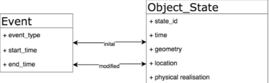
a historical source. The figure 5 represents the event-based approach as proposed in the 266
model. An event links two states together. The first state is considered as the initial state 267
and the second one as the modified state. In doing so it is possible to retrieve the history of a 268
succession of modified states by querying the relation recursively a sufficient number of time. 269
Uncertainty related to object temporality definition is not encompassed straightforward in 270
the model. Some extension based on archaeological proposition will be considered in a near 271
future.
Figure 5 Event-based change modelling. Each changes are described with an individual event
linking the initial and the modified state of the object.
272
2.5
Geometry is not location
273
As explained in the previous section, the evolution of cultural heritage object has to consider 274
separately the geometry of an object compare to its location. When planning a project or 275
analysing a sources, the shape of an object is defined or retrieved. In most cases, the link 276
between the shape of the object and its location in the environment is not straightforward. 277
Considering the transformation occurring to building’s parts, each states holds a different 278
geometry although the location of the whole building can remain stable. When considering 279
historical sources, the retrieved information can inform on a geometry (the shape of the 280
transformation) without giving explicit information on the location. Depending on the 281
uncertainty of discovered information, the location can be considered as unknown if the 282
location precision is significanlty higher than expected. For example, if the sources refers to 283
a transformation that occurs in Europe, the location vagueness does not give information on 284
the transformation location within a specific building. 285
3
STS-Model applied to Cultural Heritage
286
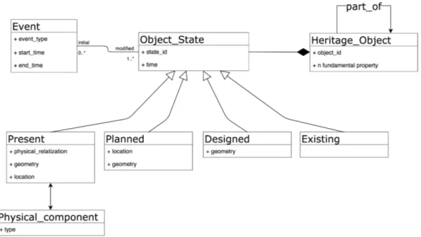
In this section, we combine the four proposed statement into a single useful model to manage 287
all the diversity of built heritage information. The proposed model is dedicated to serve 288
as a basis for a heritage documentation system. The development takes place in a specific 289
framework that aims at proposing a virtual notebook for researchers from multiple discipline 290
to gather all historical information in a same information system. This information system is 291
designed to spatially reference every object’s location (when available) on a 3D representation. 292
The location in the 3D model has to be seen as an indexation scheme. Note that the 293
Figure 6 Conceptual model for cultural heritage object information management considering
different states of knowledge related to states objects.
information which does not have a location is also referenced in the system through the 294
object states. 295
The model presented in figure 6 shows the cumulative object states that compose an 296
heritage object. The object state specializes in states of knowledge as proposed previously. 297
Each state is linked to an event which is the container of the semantic information related to 298
the modification that occurs to heritage objects. The states of knowledge are the present 299
state, for an object that has a geometry, a location and which is related to some physical 300
components (as concrete, a brick, a plaster...). The planned state is a state where the object 301
has a known location and geometry but no link with a physical component. This is for 302
example the case of a building for which we did a survey (i.e. with a known geometry 303
and location) but that is now destroyed. The planned state keeps only the geometry and 304
location in the system as a memory. Note that when an heritage object has a location, it 305
implicitly define some object geometry. Even if the geometry definition is not accurate, it 306
is at minimum defined by a point which can be considered as a first basic geometry. The 307
designed state class gathers objects for which the spatial definition is known without location 308
and link to a physical component. This is the typical example of a planned building part 309
transformation where the exact location is unknown depspite the plan conservation. Finally, 310
the existing state group objects for which only identity is known. For instance, cultural 311
heritage researchers know that a transformation took place in an edifice but do not know the 312
nature, the geometrical description or the location of the transformation. 313
The model links together two vision of the successive knowledge states related to an 314
edifice. First, a constructive vision where the knowledge is constructed step-by-step according 315
a classic scheme of existence, designed, planned and present object. The second vision is 316
the reference of historical sources where the retrieved information related to heritage are 317
rarely exhaustive. By definition, researchers face to incomplete knowledge and have to draw 318
hypothesis to extrapolate what could happened between to temporal successive states of 319
knowledge. By its construction the models is suitable for the latter vision. Each source is 320
analysed in order to be classified in regards of the state of knowledge taxonomy. In this case, 321
the knowledge related to an edifice is not necessary constructed in the ordered succession of 322
states. The states of knowledge encompass the diversity of the historical sources that are 323
usually referenced on a cultural heritage element. 324
4
Perspective and futures developments
325
This research takes place in the project VP-Num initiated at the University of Liège. This 326
projects aims at studying the heritage values that building numeric representation can hold 327
especially if it is destroyed or not accessible for a long period of time. The project focusses 328
on two remarkable edifice of the city of Liège, Belgium. The first one is the “Collégiale 329
Sainte Croix”, a gothic church initially constructed during the XXth century and transformed 330
several times during the XIVth and the XVIIIth century [17]. The successive transformation 331
focused on building parts and finally completely changed its appearance ranging from Roman 332
to Gothic style. This building is not accessible for the public for safety reasons. It will 333
now enter in a deep renovation phases which will last for at least ten years. The second 334
edifice studied in the project is the Hotel Rigo building. This building from the beginning of 335
the XXIth century was a symbol of the rich aristocracy of the city of Liège. Due to urban 336
planning necessities following the construction of a new railway station, this building has 337
been completely destroyed. Actually, there is no remains that shows the former presence of a 338
building at that place. In this framework, the proposed model will provide to researchers a 339
framework where the two building can continue to be studied. For both of the two buildings 340
we made a complete survey in order to create a digital 3D model in the form of a point cloud 341
and they have been documented to propose virtual visits. Some intermediary results are 342
presented in figure 7 and figure 8. 343
Figure 7 Panorama of the interior of the Hotel Rigo, Liège. These images helps at colouring the
acquired point clouds from laser scanner devices.
The semantic information which is associated to the two building will be organized 344
following the proposed model. For the first case, most of the building is in a present state of 345
knowledge since the building is still in place. The relationships between the 3D documentation 346
(the point cloud) and the building is valid. The Hotel Rigo does not share a relation with a 347
physical element any more since it has been destroyed. The complete edifice is in a planned 348
state, i.e. there is an information on the geometry, the location, the identity of the element. 349
Note that some parts of the edifice has been conserved. The saved parts are in a present 350
states even if they location has changed. The Collégiale Sainte-Croix has fundamentally 351
changed of shape during the past centuries. There is a lot of sources relating the existence 352
of a primitive church, but only a few information on its geometry. Following the proposed 353
taxonomy, the primitive church is in a existence state of knowledge. The only remaining 354
information is its identity, since even its location is not known in the site. In the following
Figure 8 Subset of the 3D point clould of the Collégiale Sainte Croix, Liège Belgium. This survey
has been realised in collaboration with the SPW-DGO4-AWAP and Jean-Noël Anslijn.
355
we plan to implement the proposed model and link the geometric information to a 3D model 356
visualization tools. By the way, the researchers could also access to the information through 357
the 3D interface. 358
5
Conclusion
359
The cultural heritage information is characterized by a strong relation with time and a 360
frequent lack of information. These two fundamentals characteristics cause some difficulties to 361
manage heritage information with standards geographical information or building information 362
modelling systems. In order to encompass all the possible diversity in term of knowledge, 363
tailored spatio-temporal data models has to be proposed. In this research, we throw the basis 364
for a heritage information model that take into account the successive states of knowledge 365
that the research can provide to an edifice. Instead of considering that historical sources 366
are incomplete information, we proposed a taxonomy imitated from the cumulative states 367
of knowledge that occurs when a building projects is realized. The taxonomy proposes a 368
vision where the identity, the location, the geometry and the physical realization are the 369
keys to classify the knowledge states. Moreover, the states are proposed to be a cumulative 370
set that compose a more generic spatiotemporal object which is the heritage object. This 371
allows to keep structured all the information in relation to an heritage building and not 372
having to select or dispose of hypothesis when recording the information. The model will 373
serve as a fundamental brick for a broader project related to the values hold by the digital 374
representation of build heritage. During the last couple of years a lot of heritage building 375
and site has been destroyed due to wars or ideological purposes. For some of them, a survey 376
have been realized or a digital reconstruction can be done using photography. The digital 377
representation of these objects is the only remains of their geometric description. As far as 378
the conservation process cannot be performed on the physical object, we need to report the 379
process to the digital representation since it is the last container of most heritage values. 380
The heritage information models have to be modeled in that way. 381
References 382
1 Y Arayici, J Counsell, L Mahdjoubi, and GA Nagy. Heritage Building 383
Information Modelling. Taylor & Francis, 2017. URL: https://books. 384 google.be/books?hl=fr{&}lr={&}id=pzMlDwAAQBAJ{&}oi=fnd{&}pg=PP1{&}ots= 385 gOSUEdVpfa{&}sig=a7XzKfCdWiWAkLlCberfUuBcvIghttps://www.taylorfrancis.com/ 386 books/9781315628011, doi:10.4324/9781315628011. 387
2 Alberto Belussi and Sara Migliorini. A spatio-temporal framework for managing archeolo-388
gical data. Annals of Mathematics and Artificial Intelligence, 80(3):175–218, 2017. URL: 389
http://dx.doi.org/10.1007/s10472-017-9535-0, doi:10.1007/s10472-017-9535-0. 390
3 John Castleford. Archaeology, GIS, and the time dimension: an overview. 391
In CAA1991. Computer Applications and Quantitative Methods in Archae-392
ology 1991, pages 95–106. BAR (BAR International Series S577), 1992. URL: 393
https://publikationen.uni-tuebingen.de/xmlui/bitstream/handle/10900/61168/ 394
13{_}Castleford{_}CAA{_}1991.pdf?sequence=2. 395
4 Erik Costamagna and Antonia Spanò. CityGML for architectural heritage. In 396
Lecture Notes in Geoinformation and Cartography, number 199639, pages 219–237. 397
Springer, Berlin, Heidelberg, 2013. URL: http://link.springer.com/10.1007/ 398
978-3-642-36379-5{_}14, doi:10.1007/978-3-642-36379-5_14. 399
5 Marta De la Torre. Values and heritage conservation. Heritage & Society, 6(2):155–166, 400
2013. 401
6 Martin Doerr. The CIDOC conceptual reference module: an ontological approach to se-402
mantic interoperability of metadata. AI magazine, 24(3):75, 2003. 403
7 Stephen Fai, Katie Graham, Todd Duckworth, Nevil Wood, and Ramtin Attar. Build-404
ing Information Modelling and Heritage Documentation. Proceedings of the 23rd Inter-405
national Symposium, International Scientific Committee for Documentation of Cultural 406
Heritage (CIPA), pages 12–16, 2011. URL: https://pdfs.semanticscholar.org/b76a/ 407
6be1ab4c5c148757eac8c73dc7a5c2995999.pdf. 408
8 S Ferret. Le bateau de Thésée: le problème de l’identité à travers le temps. Éditions de 409
Minuit, 1996. 410
9 Simone Garagnani. Semantic representation of accurate surveys for the cultural heritage: 411
BIM applied to the existing domain. In Civil and Environmental Engineering: Concepts, 412
Methodologies, Tools, and Applications, pages 931–949. IGI Global, 2016. 413
10 Pierre Hallot. Considering rich spatiotemporal relationships in cultural heritage in-414
formation management. In Lecture Notes in Geoinformation and Cartography, number 415
198809, pages 339–347. Springer, 2018. URL: http://link.springer.com/10.1007/ 416
978-3-319-63946-8{_}51, doi:10.1007/978-3-319-63946-8_51. 417
11 Pierre Hallot and Roland Billen. Enhancing Spatio-Temporal Identity: States of Existence 418
and Presence, 2016. doi:10.3390/ijgi5050062. 419
12 Pierre Hallot, Kathleen Stewart, and Roland Billen. Les états spatiotemporels d’existence 420
et de présence. International Journal of Geomatics and Spatial Analysis, 25(2):173–196, 421
2015. doi:10.3166/RIG.25.173-196. 422
13 L. Jianya, G. Xiaolong. Spatiotemporal Data Model for Real-time GIS. Acta Geodaetica et 423
Cartographica Sinica, (April), 2017. URL: https://www.ingentaconnect.com/content/ 424
doaj/10011595/2016/00000043/00000003/art00001, doi:10.13485/j.cnki.11-2089. 425
2014.0033. 426
14 D Koller, B Frischer, and G Humphreys. Research challenges for digital archives of 3D 427
cultural heritage models. on computing and cultural heritage ( . . . , 2009. URL: http: 428
//dl.acm.org/citation.cfm?id=1658347. 429
15 Randall Mason et al. Assessing values in conservation planning: methodological issues and 430
choices. Assessing the values of cultural heritage, pages 5–30, 2002. 431
16 Sara Migliorini, Piergiovanna Grossi, and Alberto Belussi. An interoperable spatio-432
temporal model for archaeological data based on iso standard 19100. Journal on Computing 433
and Cultural Heritage (JOCCH), 11(1):5, 2017. 434
17 M Piavaux. La collégiale Sainte-Croix à Liège. Formes et modèles dans l’architecture du 435
Saint-Empire. XIIIe-XVe siècles. Presses universitaires de Namur., Namur, 2013. 436
18 Florent Poux, Romain Neuville, Pierre Hallot, and Roland Billen. Model 437
for Reasoning From Semantically Rich Point Cloud Data. ISPRS Annals 438
of Photogrammetry, Remote Sensing and Spatial Information Sciences, IV-439
4/W5(October):107–115, 2017. URL: https://orbi.uliege.be/handle/2268/ 440 215651https://www.isprs-ann-photogramm-remote-sens-spatial-inf-sci. 441 net/IV-4-W5/107/2017/{%}0Ahttps://www.researchgate.net/publication/ 442 320573406{_}MODEL{_}FOR{_}SEMANTICALLY{_}RICH{_}POINT{_}CLOUD{_}DATA, 443 doi:https://doi.org/10.5194/isprs-annals-IV-4-W5-107-2017. 444
19 Mario Santana Quintero, Bill Blake, and Rand Eppich. Conservation of Architectural 445
Heritage: The Role of Digital Documentation Tools: The Need for Appropriate Teach-446
ing Material. International Journal of Architectural Computing, 5(2):239–253, jun 2007. 447
URL: http://journals.sagepub.com/doi/10.1260/1478-0771.5.2.240, doi:10.1260/ 448
1478-0771.5.2.240. 449
20 Fabio Remondino. Heritage Recording and 3D Modeling with Photogrammetry and 3D 450
Scanning. Remote Sensing, 3(12):1104–1138, may 2011. URL: http://www.mdpi.com/ 451
2072-4292/3/6/1104/htm, doi:10.3390/rs3061104. 452
21 Shih Lung Shaw, Hongbo Yu, and Leonard S Bombom. A space-time gis approach to 453
exploring large individual-based spatiotemporal datasets. Transactions in GIS, 12(4):425– 454
441, aug 2008. URL: http://doi.wiley.com/10.1111/j.1467-9671.2008.01114.x, doi: 455
10.1111/j.1467-9671.2008.01114.x. 456
22 Muriel Van Ruymbeke, Cyril Carré, Vincent Delfosse, Michelle Pfeiffer, and Roland Billen. 457
Towards an Archaeological Information System: Improving the Core Data Model. In F. Gi-458
ligny, F. Djindjian, L. Costa, P. Moscati, and S. Robert, editors, CAA 2014 21st century 459
Archaeology : Concepts methods and tools : Proceedings of the 42nd Annual Conference 460
on Computer Applications and Quantitative Methods in Archaeology, pages 245–253, Paris, 461
2015. Archaeopress. 462
23 Muriel Van Ruymbeke, Pierre Hallot, Gilles-Antoine Nys, and Roland Billen. Implementa-463
tion of multiple interpretation data model concepts in CIDOC CRM and compatible models. 464
Virtual Archaeology Review, 9(19), feb 2018. URL: https://polipapers.upv.es/index. 465
php/var/article/view/8884, doi:10.4995/var.2018.8884. 466
24 Marilena Vecco. A definition of cultural heritage: From the tangible to the intangible. 467
Journal of Cultural Heritage, 11(3):321–324, jul 2010. URL: https://www.sciencedirect. 468
com/science/article/pii/S1296207410000361, doi:10.1016/J.CULHER.2010.01.006. 469
25 Morton E Winston, Roger Chaffin, and Douglas Herrmann. A taxonomy of 470
part-whole relations. Cognitive Science, 11(4):417–444, 1987. URL: http://www. 471
sciencedirect.com/science/article/pii/S0364021387800150, doi:http://dx.doi. 472
org/10.1016/S0364-0213(87)80015-0. 473
26 N Yastikli. Documentation of cultural heritage using digital photogrammetry and laser 474
scanning. Journal of Cultural Heritage, 2007. URL: http://www.sciencedirect.com/ 475
science/article/pii/S1296207407001082. 476