Project no. 505428 (GOCE)
AquaTerra
Integrated Modelling of the river-sediment-soil-groundwater system; advanced tools for the management of catchment areas and river basins in the context of
global change Integrated Project
Thematic Priority: Sustainable development, global change and ecosystems
Deliverable No.: Basin R3.7 and R3.10
Title R3.7: Chapter in BASIN report on structured research results for further interpretation in terms of management
tools/approaches for river basin management
(INTEGRATOR), and in terms of EU policy impacts (EUPOL), delivered to the steering committee
Title R3.10: Overview of analysis results for the Dommel catchment system
Due date of deliverable: May 2005 Actual submission date: May 2005
Start date of project: 01 June 2004 Duration: 60 months Organisation name and contact of lead contractor and other contributing
partners for this deliverable:
J. Joziasse, TNO, P.O. Box 342, 7300 AH Apeldoorn, The Netherlands J. Vink, RIZA, Lelystad, The Netherlands
S. Brouyère, HGULg, Liège, Belgium C. van der Wielen, ISSeP, Liège, Belgium
Revision: H. Rijnaarts, J. Barth Project co-funded by the European Commission within the Sixth Framework
Programme (2002-2006) Dissemination Level PU Public
PP Restricted to other programme participants (including the Commission Services) X RE Restricted to a group specified by the consortium (including the Commission Services)
SUMMARY
An overview is presented of the research activities conducted by several AquaTerra work packages (BASIN, TREND, FLUX, BIOGEOCHEM) in the Meuse basin, with the emphasis on two specific sites: the Walloon region and the Dommel catchment. The preliminary results and the relevance for management issues are presented. Furthermore, the
progress in the formation of a stakeholder group and the organisation of a workshop with these stakeholders is reported.
MILESTONES REACHED (from DOW p. 80 – 85)
• R3.1: Assessment of end user boundary conditions in managing the Meuse and research questions in BASIN and other sub-projects
• R3.2: Demands and criteria for a spatial, GIS-oriented decision support system for the Dutch Meuse basin have been defined
• R3.3: Definition of sampling location(s) and sampling requirements in the Dommel catchment tuned with TREND work package
• R3.4: Inventory of sources of information relative to the river Meuse and its alluvial plain in the Walloon region (data type, holders, formats, cost …) • R3.5: Analysis of data for identification of sites, appropriate conditions and
Deliverable R3.7
Chapter in BASIN report on structured research results for further interpretation in terms of management tools/approaches for river basin management (INTEGRATOR), and in terms of EU policy impacts, delivered to the steering committee.
1. Introduction
The Meuse is a rain river with a length of about 925 km, a basin area of 33.000 km2 and a discharge that varies between 5 m3/s in dry summer periods and over 3,000 m3/s in wet winter or spring periods. The river rises in the northern part of France, flows through Belgium and the Netherlands and drains into the North Sea. The Meuse and its tributaries have been (mis)used extensively for dumping domestic, industrial and mining waste. In combination with natural processes of erosion, flooding and sedimentation large areas (floodplains) were contaminated with heavy metals, PCBs and PAHs. In Belgium, several locations exist where groundwater and sediments are severely contaminated as a result of former industrial activities. Many groundwater catchment areas are located in the alluvial plain. Several wells are contaminated with herbicides and other substances transported by the river.
The objectives of the work package are:
• Development of a spatial, interactive decision support system (DSS) to calculate the chemical speciation of heavy metals in floodplain sediments under various
environmental conditions. Effects of redevelopment measures, such as river widening, storage, and nature restoration, are assessed by scenario comparisons.
• Identification of ways to improve the soil, sediment, groundwater and river quality in the Dommel (a tributary to the river Meuse)
• Quantification of groundwater quality effects by river - groundwater interaction in the Belgian part of the Meuse system.
• Quantification of coupled ecotoxicological effects of contaminants from sediment, suspended solids and freshwater on aquatic organisms in the river Meuse.
2. Detailed research plans for test area(s)
Specific test areas are located in the Walloon part of the Meuse basin and in the Dommel sub-catchment. The research carried out for these test areas will be described below. A more generic part of the work package is the development of a decision support system (DSS) to calculate the chemical speciation of heavy metals in floodplain sediments under various environmental conditions. This DSS can be used to study the effects of selected scenarios for restoration or redevelopment of the river basin on heavy metal mobility and ecotoxicological risks. The system has a modular structure and consists of a chemical and an ecotoxicological module. Deliverables have been submitted in which a functional design and a structural design are presented and in which a state-of-the-art chemical speciation module is presented, adapted to river flood plains systems with redox-dependent heavy metals. The functional design describes the functionalities and operational options that the system has to meet. The structural design describes the technical conditions and criteria to meet these functionalities.
The objective of the BIOGEOCHEM 1 work package activities, conducted by ETHZ, is to investigate the mechanisms responsible for the release of inorganic and organic pollutants from contaminated floodplain soils. As variable groundwater levels and/or occasional flooding may cause seasonal variations in redox conditions in these soils, they study contaminant mobility under fluctuating redox conditions in laboratory-scale
microcosm and column experiments filled with either homogenized or undisturbed floodplain soil samples. A site with suitable conditions for their research has been selected along the Meuse basin. This site may also be of interest to the Tübingen University for their work in the BIOGEOCHEM 2 work package in which sorption isotherms of organic compounds in sediment and soil samples are determined. In the next period also BIOGEOCHEM 3 may expand their research activities to Meuse sites for mineralogical and geochemical characterisation of soil, sediment and water samples and biodiversity characterisations.
The Walloon test sites
The Flémalle former cokery is a brownfield of 7.3 ha, located in the left bank of the river Meuse, close to the river (10 – 15 m), upstream from Liège, where various activities in connection with coking processes were carried out in the past, between 1922 and 1984. These activities have produced an important contamination of soil, subsoil and groundwater. The site has been selected for several reasons. It is close to the Meuse river, which makes it interesting for HGULg research activities on groundwater – surface water interactions in relation with groundwater contamination issues. Furthermore, previous investigation campaigns have highlighted the existence of a large variety of contaminants, at relatively high concentrations, in both the unsaturated zone and the saturated alluvial deposits, such as BTEX, PAH, cyanides, heavy metals, mineral oils... This is interesting for HGULg as well as for different AquaTerra partners involved in the work package BIOGEOCHEM: CHYN-UNINE, VITO, BRGM and UHT. The final objectives of all experiments carried out by the AquaTerra partners is to propose an optimal measure for decontamination of the site, taking into account all the aspects studied in-situ and ex-situ.
For HGULg, various experiments are foreseen in the field: infiltration and pumping tests in the saturated zone (upper and deep alluvial deposits), tracer experiments using different experimental setup, including a new tracer test methodology called the Finite Volume Point Dilution Method (FVPDM). Geophysical campaigns are also foreseen (seismic sounding and electrical tomography) for a cartography of the bedrock altitude (important for DNAPL migration) and for better characterizing the heterogeneity of the alluvial deposits. Finally, groundwater modelling has just started, using existing and already collected data.
The Geer basin, a tributary to the river Meuse, is located in the eastern part of Belgium, North-West from Liège. A very important groundwater resource is located in this basin: the Hesbaye aquifer. This aquifer supplies drinking water to about 600,000 people in Liège and its suburbs, which means approximately 30 million m3, which are pumped out by galleries and pumping wells annually. The Geer basin has been recently selected, because of several interesting characteristics for the AquaTerra project. First, this basin has been the topic of several research projects and investigations by HGULg, including modelling, and an important dataset is available. This makes it an interesting case study for research activities in relation with the COMPUTE work package. From a quantitative point of view, this groundwater resource is of major importance for the Walloon region. Any reduction in groundwater recharge in the future, e.g. in relation with climate change, could have major consequences for water distribution in the region. Research activities related to estimating the impact of climate change on water / groundwater resources in the Geer basin (HYDRO H1) are thus of major interest. Finally, because of the existence of a thick layer of loess, the region is intensively cultivated. Presently, nitrate concentrations are close to the drinking water limit (40 mg/l). From time to time, pesticides (mainly atrazine) have also been detected in some observation and pumping wells. Estimation of present and future groundwater quality trends in this basin is of high importance for supporting any decisions in terms of land use (changes in agricultural practices etc). The Geer basin will thus be the focus of HGULg research activities in TREND T2 (groundwater quality trends), using both statistical trend analysis techniques and modelling tools. An isotopic campaign is also on the way, in relation with HGULg activities in TREND T2. This might provide a way of calibrating large-scale groundwater flow and transport models.
For the ecotoxicological research in connection with the ISSeP activities five sampling points have been chosen along the Belgian part of the Meuse river : Dave above Namur, Andenne near the contaminated site of Sclaigneux, Visé where bioaccumulation of PCB and dioxins are suspected to occur. Two tributaries were added : the Sambre at Namur and the Vesdre at Vaux-sous-Chèvremont. These sites were selected, based on ISSeP’s experience in basin studies and ecotoxicological data management and on discussions with its partners. Important arguments for this selection were the availability of historical data from the subsurface water network and the availability of information from ecotoxicological studies of this river and its tributaries. The sites are also of interest as potential sediment sampling locations for the TREND work package that is looking for a silty reference sediment. Moreover, stakeholders from the Walloon ministry are interested in the study.
Sediments and suspended solids are to be collected and analysed using a battery of bioassays that combine different trophic levels and different functions, exposure routes and sensitivities. Complementary chemical analyses will be performed in order to study the “degree of metal contamination” and to support the interpretation of endpoints results. Three surveys are planned.
The information collected from analysis of sediments and suspended solids will be very useful for taking into account the effects on aquatic organisms. This has to be considered as part of the chemical and biological information for a “Triad-oriented” analysis of river water functioning.
The Dommel sub-catchment
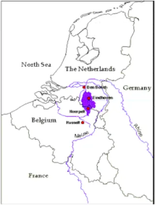
The study area is located in the Dommel catchment area, between the city of Eindhoven and the Dutch/Belgian border (see figure 1). The Dommel is a second to third order lowland stream situated in the Kempen, an area extending over northern parts of Belgium and southern parts of the Netherlands with about 600,000 inhabitants. The catchment area is about 1350 km2 and the soil consists of sand and loamy sand layers of Pleistocene age. The mean annual rainfall amounts to 740 mm. The reference evapotranspiration for grassland is 560 mm yr-1 and the average annual runoff is 190 mm yr-1. Groundwater seepage contributes 70 % to the annual runoff for the Dommel catchment. Agriculture occupies 56 % of the catchment area, mainly corn and grassland with some arable farming and tree cultivation.
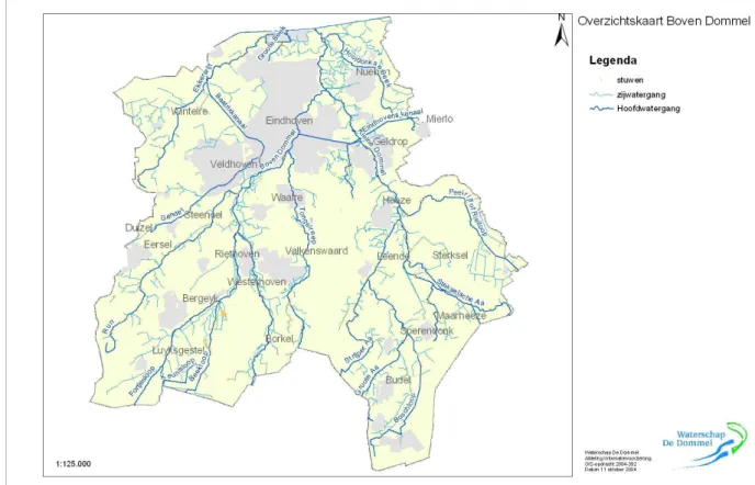
The Dommel has a length of about 140 km (20 km in Belgium, 120 km in the Netherlands), covering a height distance of 35 m from its spring (near the Belgian city
of Peer) to its confluence with the river Meuse with a maximum slope of about 1 %. It has a sandy bottom, a width of 5 - 7 m, a depth of 0.4 - 1.5 m, a current velocity varying between 0.5 and 1.0 m·s-1, and pH neutral waters with a naturally high iron content. A number of tributaries are part of the Dommel catchment, such as the Beerze, Run,
Keersop, Beekloop, Tongelreep and Kleine Dommel. Figure 2 gives an impression of the geographical arrangement of these tributaries.
The area is traversed by a number of canals which possibly infiltrate into the groundwater. The soil material in all canals is sand. The water level in the canals is regulated very strictly. Table 1 gives an overview of the canals present in the area.
The main waterways in the area (besides the Dommel itself) are described below:
• The Tongelreep (in Belgium called the Warmbeek) rises near Peer and flows into the Dommel in the city of Eindhoven;
• The Kleine Dommel rises partly in the Dutch province of Limburg near Hogten and flows into the Dommel between Eindhoven and Nuenen. One of the main tributaries of the Kleine Dommel is the Groote Aa which rises in Belgium near Hamont-Achel and flows into the Kleine Dommel near Leende;
• The Beerze flows into the Dommel just before the city of Boxtel. The Beerze has a number of tributaries, among which the Kleine Beerze and the Grote Beerze. Part of the Beerze is diverted to the Reusel upstream of Boxtel;
• The Hooidonkse beek rises near Stiphout and flows into the Dommel near Hooidonk; • The Run rises near Weebosch and flows into the Dommel near Veldhoven;
• The Keersop rises in Belgium via the Elsenloop and the Klachtloop. After confluence with the Beekloop near Westerhoven, it flows into the Dommel near Waalre.
Table 1. Canals in the Dommel catchment area
Canal Water level
(m above NAP)* Width (m) Depth (m) Geographical description Zuid-Willemsvaart
27.06 (Dutch province of Limburg) 4.70 (at ‘s-Hertogenbosch)
24 2.6 Direction South-east to North-west; decrease in water level regulated by 13 weirs Kanaal
Bocholt-Herentals
40.56 (at Lommel) 35 4 Situated in Belgium; traverses the area from East to West Eindhovens
kanaal
18.5 19 2.5 Connects Eindhoven to the
Zuid-Willemsvaart in a West-East direction
Wilhelmina kanaal
15 22 3.5 Connects the
Zuid-Willemsvaart to the city of Tilburg in a West-East direction Beatrix
kanaal
15 22 3.5 Connects Eindhoven to the
Wilhelmina kanaal in South-North direction
* NAP is a reference level in the Netherlands
In most places, the Dommel river is eroded into the landscape, but floodings do occur, mainly in the spring. The Dommel flow is regulated by sluices and dams, where sedimentation of suspended solids takes place. Sediment traps are used to enhance downstream river water quality. One is constructed in the Tongelreep near the Dutch/Belgian border.
In the Kempen area, three zinc-ore smelters are located within 10 km from each other. A fourth was shut down in 1973. Exhaust fumes from these smelters have emitted oxides of heavy metals for about one century, which have reached the soil either by dry deposition or with rainfall. As a result of this, the soils in the Kempen are heavily contaminated with cadmium and zinc on a regional scale. Since the seventies, the cadmium and zinc atmospheric emissions have been greatly reduced, due to changes in the production process. However, in the same period agricultural activities changed from dairy farming to intensive livestock farming. The manure of this type of farming is spread on a relative small area of land, mainly in the months of February and March. It then leads to a large load of nitrate, phosphate and metals (i.e. cadmium). However, the agricultural load of heavy metals is small compared to the historic deposition in the vicinity of the smelters.
The Dommel catchment serves as an important research area for the work packages TREND and FLUX. In the TREND 1 work package the objective of the Wageningen University research carried out in the first year is to determine the temporal variation of metal availability in a river system. For one year AVS–SEM (a measure for metal availability in sediments) is monitored on several locations in the Dommel basin. In this way, the influence of short term changes like seasonality and flooding events on metal availability can be determined. In addition, a better understanding of the processes controlling metal availability will allow prediction of future changes due to long term changes like global warming. Implications of the availability of the metals for the ecological risk will be addressed by other AquaTerra participants.
Seven sampling sites were selected in the Dommel River or its tributaries, in order to maximize variation in site conditions. Three of the sites will be sampled monthly for a one year-cycle, of which 10 months have been completed so far. The remaining sites were sampled twice, in winter and summer. On two of the monthly sampled sites, also samples from the floodplain adjacent to the river are taken. Both floodplains are likely to be influenced by flooding at least once a year. Sampling site characteristics are shown in table 2. A detailed description of the sampling sites is given in deliverable T1.6.
Table 2. Sampling site characteristics T1 research (WUR) CAN YOU INDICATE LAT LONG VALUES HERE
Site Code Lattitude
(decimal degrees)
Longitude (decimal degrees)
River Sampled Flow Sediment
Liskesbrug LB 51.277003 5.381467 Beekloop monthly low fine grained, organic rich top layer
(0-15cm), sandy bottom Westerhoven WH 51.330822 5.404059 Keersop monthly high reddish-brown,
sandy top layer (0-2 cm), light coloured sandy bottom
Timmereind TE 51.374862 5.423464 Dommel monthly high homogeneous light-coloured sand Schaftse Brug SB 51.299009 5.448675 Dommel summer/ winter high homogeneous light-coloured sand Waalre-South
WE-S 51.388234 5.417728 Dommel summer/ winter high homogeneous light-coloured sand Onze Lieve Vrouwebrug
OLV 51.400815 5.427616 Dommel summer/ winter
high fine grained, organic rich top layer
(0-2cm), light-coloured sandy bottom
Klotputten KP 51.408028 5.437722 Dommel summer moderate organic rich top layer, sandy bottom
On the sampling site South, and three other locations (Keersopperdreef, Waalre-North, Nijnsel), the pollution of the soil of the river banks is monitored by the Vrije Universiteit Amsterdam. The objective of their research is to gain insight in the general “health” of the ecosystem, using the Neutral Red Retention (NRRT) assay. This assay measures the time it takes for 50 % of earthworm cytosol cells, which is an indication of the health of the earthworm population, which in turn is believed to be indicative for the health of the ecosystem, as earthworms play an important role in decomposition and nutrient cycling in soil and the processes involved in soil structuring.
From January 2005 onwards, soil and earthworms are sampled every four weeks at each of the four sampling sites. From this sampling schedule, which will continue for one year, an insight in the dynamics of earthworm densities and biomass, as well as species composition will be obtained. A correlation with certain soil characteristics (pH, metal concentrations) will be investigated. More details can be found in deliverable T1.2.
Sediment toxicity of the site Liskesbrug was assessed by the Technische Universität Hamburg Harburg, also in the TREND 1 work package, using a battery of bioassays. Sediment from the sites Liskesbrug (Beekloop) and Klotputten (sediment trap in the Dommel) have also been used by TNO in an organic matter decomposition study. This study is conducted, because heavy metal contamination is the suspect cause of a decreased, or at some sites even completely stopped mineralisation of organic material, and thus an impacted ecological functioning of floodplains. In the study, a protocol is developed for assessing the mineralisation status in sediment impacted by perturbations. To establish the protocol, leaf breakdown experiments were performed to define a reference data range to determine ecological functioning, and to define a data range of
ecological functioning in the presence of perturbations. In the laboratory, test systems were set up containing Dommel catchment sediments differing in pollutants. Degradation and mineralisation of litter was studied as the model process to test the resilience of sediment functioning in response to perturbations (climate change: raising temperature and pollution). Litter was introduced into the system as alder leaf packs. More details can be found in deliverable T1.3.
Apart from the TREND 1 work package, also the TREND 2 work package investigating trends in groundwater, is active in the Dommel catchment area. Their results will become available at month 18. For more information on their research activities, see deliverable T2.1.
The research of the FLUX 3 work package in the Meuse/Dommel catchment is aimed at the determination of sources and fluxes of water, sediment and contaminants in the system. The main focus is the relationship between the heavy metal pollution caused by the Zn smelters and the load of these metals in the Dommel river and its tributaries. To this end an inventory of the existing data (waterboard de Dommel and regional soil survey of Utrecht University and TNO-NITG) was carried out first. Next, a geochemical survey was carried out in which (filtered) river water samples, suspended matter, bottom sediment and floodplain soils were sampled and analyzed. All data are gathered in Arc-view to obtain spatial information. The data of the waterboard de Dommel show that Zn and Cd are enriched in the unfiltered water samples of the Dommel river and its tributaries. However from the available data it cannot be seen whether or not the high values are caused by the dissolved or by the suspended load. In the geochemical survey therefore filtered water, suspended solids and bottom sediments were sampled.
The monitoring plan was started in December, 2004 and comprises:
• monthly monitoring of the Dommel river before it enters the sediment trap in the city of Eindhoven;
• monthly monitoring of the Run tributary before it flows into in the Dommel;
• monthly monitoring of a small artificial lake that is completely fed by groundwater. This artificial lake is situated at the location where the Run flows into the Dommel. Detailed information can be found in the FLUX 3 progress report.
3. Stakeholders group for the river basin
Three meetings have been organized at the office of the waterboard (Waterschap de Dommel), attended by the AquaTerra partners involved in research activities in the area (BIOGEOCHEM, FLUX, TREND, BASIN). In co-operation with BRGM (the INTEGRATOR 2 work package) a workshop with stakeholders in the Meuse river basin has been prepared. This workshop was first planned to be held in the month of April (to be hosted by ISSeP in Liège), but it was postponed to the month of September (probably September 15th, 2005) to make it possible for more people to attend. The agenda of the workshop is presented below:
Meuse stakeholders Workshop Agenda
10:00 – 10:10 Welcome (by ISSeP)
10:10 – 10:30 General introduction, workshop objective, organisation
10:30 – 10:45 Results of the global change impacts analysis
10:45 – 11:15 Overview of the main issues identified in the Meuse river basin
11:15 – 11:30 Coffee break
11:30 –12:30 Discussion on the main issues and selection of some case studies for the economic analysis (all participants)
12:30 Lunch break
13:30 – 16:00 Expected changes and their potential impacts on the Meuse river basin for the main issues discussed in the morning (30 minutes per issue)
a. Identification of the major changes (driving forces and associated pressures).
b. Identification of the existing and potential responses to mitigate the existing and potential
future environmental and socio-economic impacts.
16:00 – 16:30 Synthesis and conclusion
The intended participants are given in table 3. Out of these people the core of the stakeholder group will be formed and a chairman and secretary will be chosen.
Besides the stakeholders from table 3, a number of AquaTerra participants are likely to attend, among them:
C. van der Wielen (ISSeP), M. Hemart (ISSeP), S. Brouyère (HGULg), J. Battle Aguilar (HGULg), J. Vink (RIZA), M. Boudzid (BRGM), C. Hérivaux (BRGM), E. Ansink (WUR), L. Gerrits (TNO), H. Rijnaarts (TNO), J. Brils (TNO), J. Joziasse (TNO).
Table 3. List of stakeholders/workshop participants
Name Institution Country
P. Racot International Meuse Commission Int.
D. Besozzi Agence de l'Eau Rhin Meuse FR
L. Bijlmakers / A. Kolkman Waterboard De Dommel NL E. Kessels Active Soil Management De Kempen (ABdK) NL M. van Rossenberg Rijkswaterstaat Directie Limburg NL W. van Leussen Coördination agency Rhine-Meuse (CRM) NL P. van Diepenbeek Drinking water company Limburg (WML) NL B. de Kerckhove /
J. Derouane / D. Wylock Ministry of the Walloon Region / DGRNE BE-W J-M. Hiver Ministry of the Walloon Region / MET BE-W H. Halen Soc. Publ. d’Aide à la Qualité de l’Environnement (SPAQUE) BE-W V. van den Langenbergh Flemish Environment Agency - VMM BE-F Frotscher-Hoof Department of Environment NRW DE For the next institutions the representatives have to be detailed:
RIWA-Meuse (River WAter companies) INT EUREAU (European union of national
associations of water suppliers and
wastewater services) INT
Groupe Transnational Inondation Meuse –
GTIM Int.
RIZA NL
VEWIN (Association of Dutch Water
companies) NL
GIMPE (Groupement des Industries et Entreprises du bassin de la Meuse pour la
Protection de l'Environnement) BE-W
Société Wallone des eaux BE-W
SPE (Public Electricity Supplier) BE-W AQUAFIN (Flanders' public/private waste
water treatment company) BE-F
DIREN Lorraine (Direction régionale de
l’environnement Lorraine) FR
DRAF (Direction Régionale de l’Agriculture et de la Forêt) Lorraine et Champagne Ardenne FR DRIRE (Direction Régionale de l’Industrie et
de la Recherche) Lorraine et Champagne
Ardenne FR
EPAMA (Etablissement Public d'Aménagement de la Meuse et de ses Affluents) FR
4. Management issues to be considered
Based on advancing insight into the progress to be expected, a few small changes to the original DOW (months 1–18) have been proposed in the second DOW (months 13-30): For the chemical speciation and fauna/biota uptake decision support system (DSS) the planned deliverables are:
• R3.13: Work plan to apply the DSS in the Dommel sub-catchment (Month18; RIZA / TNO)
(flora and fauna) (Month 18; RIZA / TNO) The milestones are phrased as follows:
• R3.6: Steps for realization of DSS for the Meuse have been defined (Month 18)
• R3.7: Data analysis for Dommel samples performed, plan for application of the DSS in the Dommel sub-catchment ready (Month 18)
• R3.10: Transfer functions for DSS tuned with TREND 1 participants and ISSeP (Month 30)
The HGULg activities in BASIN involved an earlier selection of the test sites than originally planned in the first DOW. Consequently, deliverable R3.11 already contained detailed information on the test sites. Therefore, the originally planned deliverable R3.17, titled: “Documentation of site equipment and description of planned hydrogeological experiments in the Walloon Meuse catchment region” (due after 18 months) will be replaced with:
• R3.15: Documentation of site equipment and description of experiments performed and still planned in the Flémalle former cokery test site” (Month 18; HGULg)
Additionally, the following deliverables are planned, with respect to the activities in the Geer basin:
• R3.16: Description of hydrogeological conditions in the Geer sub-catchment and synthesis of available data for groundwater modelling in that basin (Month 21; HGULg) • R3.18 (combined with TREND T2): Groundwater flow and transport model delivered for
groundwater quality trend forecasting by TREND T2 (Month 24; HGULg).
• R3.19: Intermediate report on the development of the Geer hydrological (surface and subsurface water) for climatic change scenario on that sub-catchment (Month 30; HGULg)
The following milestones have been defined for the next period:
• R3.8: Piezometric surveys, groundwater sampling and monitoring for the Flémalle former cokery site performed (Month 18)
• R3.9: Groundwater flow and contaminant transport model for quantification of groundwater flow rates and contaminant mass fluxes in the Flémalle test site developed (Month 30)
For the ISSeP activities in BASIN-Meuse the following deliverables and milestones are now foreseen:
Deliverables
• R3.x: Compilation of data from additional sampling & testing (bioassays) in the Walloon catchment Region (Month 36; ISSeP)
• R3.y: Interpretation of results obtained from the ecotoxicological effects study (including chemical data, biological data & other, text and comments) (Month 42; ISSeP)
Milestones :
• R3.11: Sampling and testing (bioassays) in the Walloon Meuse catchment region performed (Month 32)
• R3.13: Collection of all the data necessary for the data analysis of the results of bioassays (Month 38)
Problems of suspended solids availability are sometimes pointed out in the ISSeP research activities. Some priorities will be set from the results obtained, in order to achieve an optimal application of the battery of bioassays.
Meetings between BASIN, TREND and FLUX researchers from TNO and COMPUTE researchers from the University of Tübingen and the University of Trento have been organized in order to bring clarity into the conditions in which the COMPUTE and HYDRO work packages can use the Meuse/Dommel basin for their research activities and to discuss the benefits for the institutes involved: what has the Meuse/Dommel to offer and
what has COMPUTE/HYDRO to offer? These issues have now largely been clarified and as a result TNO will take part in the COMPUTE 2 and 4 work package.
5. Research results
Overview of achievements so far:
Walloon Meuse catchment
The results obtained by HGULg in the Walloon Meuse catchment comprise the following: - new wells and piezometers have been drilled in Flémalle between March and April
2005;
- data have been collected for the Flémalle site (previous investigations etc.) and have been fed into the HGULg hydrogeological database (see deliverable R3.11);
- data have been collected for the Geer basin; updating of these data (pumping rates, recharge, etc.) is in progress.
For the ecotoxicological test activities by ISSeP samples have been taken from the chosen locations. The tests are currently performed on these samples. Methodologies are well defined : D. magna chronic reproduction test, C. riparius 28-days chronic reproduction test, B. calyciflorus reproduction test and V. fischeri acute test applied on sediments and suspended solids. Endpoints will be LOEC, NOEC and ECxx if series of concentrations are tested; significance testing is performed if only one concentration is used.
Data are available on the three Meuse locations. Conclusions with respect to the global scope of the study can be drawn only after the analyses have been completed. Comments may only be made on lab observations in order to highlights methodological enhancements : D. magna acute test is to be added as an interesting screening method; the 7-days C. riparius bioassay seems to be appropriate for the characterisation of sediments.
Dommel catchment
The first results from the T1 research (WUR) show that the Dommel basin is a highly dynamic system. This is reflected in a wide range of AVS-SEM values. Sediment type and surface water oxygen regime appear to be the most important factors influencing AVS concentrations. Metal availability, as predicted by the AVS–SEM method, varies spatially within the basin. However, due to seasonal changes in the surface water regime, metal availability also varies with time.
The anticipated seasonal pattern is that highest AVS concentrations occur in summer, due to the enhanced anoxia in surface water and sediments, combined with higher microbial activity at higher temperatures. In the T1 field study, AVS indeed gradually increased during summer on slow flowing locations, while SEM remained fairly constant throughout the year. On fast flowing locations, AVS and SEM were low throughout the year. The high flow velocity, even during the summer, prevents the sedimentation of organic matter and sustains oxic conditions. Conversely, on floodplains an opposite seasonal pattern is observed. AVS increased in the winter during a period of inundation, but decreased again towards the summer, following desiccation and oxidation of the soil. SEM showed hardly any fluctuations. This knowledge is of great importance when applying the AVS-SEM concept to assess the ecological risk of sediments.
Results obtained by TNO in the T1 work package show that mineralisation of leaves among used sediment qualities and temperatures vary considerably. Even within the same river (Dommel and Beekloop) there are indications that sediment quality influences mineralisation. Associative parameters should indicate which factors could have caused these differences, but organic content of the sediment seems to be an important driving factor. Associative parameters, e.g. organic content, argue for the use of a region-relevant reference material. The results show that there is an effect of temperature on
the mineralisation of leaves. Differences between sediment qualities seem to be more pronounced when temperature is higher.
The Flux 3 inventory of existing data (TNO) reveals that
• the Dommel river has the highest concentration of the metals Zn and Cd in the unfiltered water samples throughout the year;
• the Boschloop tributary has the highest Zn values, but only in the winter months; • the Dommel river and all of its tributaries have the highest Zn and Cd values in the
winter and the lowest in the summer. The Zn and Cd concentrations in the Dommel show less fluctuations than in its tributaries.
From the regional soil survey background values for 11 metals were calculated. These background values are used in the interpretation of the data obtained from the geochemical survey. The following conclusions can be drawn from this survey:
• the Dommel river water is extremely enriched in dissolved Zn, Cs, Tl, Mo, K and Rb. The most likely source for this enrichment is the waste water from a smelter;
• The tributaries to the Dommel are enriched in dissolved Zn and Ni and occasionally in Cd (e.g. the Boschloop);
• in the Dommel the concentrations of Zn and Cd decreased significantly from 2002 to 2004;
• suspended matter and bottom sediments of the Dommel and its tributaries do not contain clay. Zn, Cd and Tl are significantly enriched in the suspended matter and bottom sediments of the Dommel, compared to regional background levels;
• although flooding of the Dommel occurs with a frequency of less than once every five years, flooding has caused enrichment of Tl and Cd enrichment in the soils adjacent to the river.
Relevance for policy and river basin management:
Research activities conducted by HGULg and other partners in the scope of the AquaTerra project will provide several interesting results for decision-makers and stakeholders in the Walloon part of the Meuse basin. Experiments performed in Flémalle are likely to provide an interesting case study of typical contamination issues related to industrial activities strongly developed in the past in the Meuse alluvial plain in Liège and its suburbs. Research results will also possibly suggest specific dedicated remediation techniques, such as bioremediation, as viable alternatives to classical remediation scenarios, usually considered by the decision-makers managing such sites. Investigations performed in the Geer basin will provide useful results, tools and information, such as groundwater quality trend analysis, climate change impact and groundwater models. The Walloon authorities can use these results to optimize the management of a very important groundwater resource for the Region.
Also the AquaTerra research carried out by ISSeP will provide interesting results for decision-makers and stakeholders in the Walloon Meuse basin. Bioassays are likely to provide interesting information on ecotoxicological effects of metals, pesticides and other organic contaminants. This can be related to industrial activities strongly developed in the past in the Meuse river catchments. In this sense, the ecotoxicological approach may be considered and used as a validation tool of models.
Research results will also provide information on ecotoxicological parameters that is actually not considered in the Water Framework Directive. Using this information, based on a Triad approach (chemistry, biology, ecotoxicology) the real impact on aquatic organisms can be assessed.
In this study, sediments and suspended solids are considered for monitoring as important, additional compartments compared to actual water system policy. This approach may recognise the role of sediments within river basins, especially in terms of its effects on water quality, aquatic ecosystems and human health, and in terms of possible interventions.
From discussions with the waterboard authorities the following management issues, c.q. research questions turned out to be important:
• With respect to the distribution and spreading of contaminants: ! what is the extent and rate of spread in groundwater;
! identification and quantification of contamination sources (actual, historic, natural, anthropogenic);
! quantification of uptake by sediment from groundwater (sorption capacity); ! release of contaminants from sediment to surface water.
• With respect to the risks of inundation caused by sedimentation of contaminated material on ‘clean’ areas
! what are the risks for ecosystems (mainly aquatic systems), ! what are the human health risks (food safety, drinking water), depending on the inundation frequency
It appears that the AquaTerra research in the Dommel catchment is highly relevant for obtaining answers to these questions. For instance, the activities of T1 (temporal variation of metal availability) and R3 (the DSS system for metal speciation in various redox scenarios) directly address the questions regarding release of contaminants to surface water and risks for ecosystems.
For the selection of river basin management options it is of utmost importance that the sources and fluxes of the contaminants are revealed. This is necessary to identify individual pollution sources, to assess the effectiveness of sediment traps, etc. Therefore, also the F3 research activities are extremely relevant for water managers, both at a regional and at a river basin (i.e. national, or international) scale. The same holds for the results of the trends in groundwater (T2) research, which will indicate the rate with which contaminants are transported from soil through the groundwater into the surface water.
Contribution to generic research findings of Aquaterra:
The research carried out in the Meuse Basin contributes to the understanding of the soil-water-river system by addressing the following issues:
# The chemical and biological availability of pollutants in soil and sediment determine the impact of the pollution. In general, it can be said that only contaminants present in the water phase (either as dissolved species, or bound to dissolved organic carbon) are available for uptake by organisms. The DSS which is developed in this work package aims at relating the heavy metal speciation (thus the bioavailable fraction) to redox conditions. These redox conditions depend on flooding conditions, for instance the frequency and length of inundation periods, and thus on changes in climate and land-use.
# The ecological risks that accompany the release of contaminants from the sediments into the water phase are investigated in the Walloon part of the Meuse Basin, but are also included in the DSS mentioned above. For the module describing uptake of contaminants by plants and biota transfer functions will be determined and taken up in the model system.
# The flux of pollutants through the groundwater is strongly influenced by soil-groundwater interactions. These are investigated in the Walloon part of the Meuse Basin and in the Dommel catchment region (the latter in co-operation with the T2 work package). An interesting result is a prediction of the load of contaminants into a river system that will be transported from the groundwater into the surface water after a certain time period. Another important finding of the modelling activities is the risk that will be posed to groundwater resources in relation to human safety (drinking water for humans and cattle).