PARTICIPATORY ASSESSMENT OF A COMMUNITY’S CLIMATE RESILIENCE AND POTENTIAL FOR THE REDD+ PROGRAM IN THE DOMINICAN REPUBLIC
By
Gabriel Noël-Letendre
Essay submitted to the Centre universitaire de formation en environnement et développement durable for the Degree of Master in Environment (M. Env.)
Under the direction of Mister Darren Bardati
MAÎTRISE EN ENVIRONNEMENT UNIVERSITÉ DE SHERBROOKE
i ABSTRACT
Keywords: agroforestry, climate change adaptation, conservation, corruption, developing country, ecosystem-based management, empowerment, forest, international, public-private partnership.
To adapt to climate change, the Dominican Republic is writing its national strategy for the REDD+ program. An ongoing conservation project managed by the Fondo Agua Santo Domingo got fast and cost-effective results compatible with REDD+ activities. The Ministerio de Medio Ambiente y Recursos Naturales wants to know how it is managed and what potential it holds for REDD+. Concerns were also expressed as if the
Fondo Agua Santo Domingo only has donor-based objectives or if it also aims to improve the involved
community’s resilience. Since this community has the responsibility to maintain an ecosystem service, a climate resilience assessment would empower the participants to build resilience in their community and make external organizations aware of local considerations for sustainable development.
The methodology, inspired from the principles of the Stockholm Resilience Centre and the Community Based Resilience Assessment practical framework, encompasses the most important elements of resilience building through a qualitative and quantitative field assessment done in groups and individual interviews. The results show that the scale of a reference disturbance like hurricane Noel puts most of a household’s capitals at stake. Some pathways locally exist to improve household resilience, but external help is absolutely needed to improve the community-wide absorptive, adaptive and transformative capacities. Interventions should focus on connectivity management and diversity and redundancy maintenance in priority. The community members established that access to health services, resistant houses, access to clean water and resistant streets were their most critical climate resilience needs. Excellent REDD+ potential has been proven by participation in previous projects, communitarian solidarity, trust in the stakeholders, increasing quality of the natural capital, and respected criteria from activities in Peru and Zambia, which states agroforestry is the most optimal for land use. Based on the results, proposed recommendations should improve Santana’s resilience, should facilitate REDD+ registration, put perspective on participative conservation design and help to solve systemic corruption. The case for Santana is common across the globe, where the provision of an ecosystem service becomes the responsibility of a vulnerable community. The resilience priorities established should be considered by stakeholders as starting points for community-wide resilience building or for monitoring.
ii ACKNOWLEDGMENTS
The completion of this essay which leads finally to complete this degree is the end of an incredibly life-changing adventure. I would like to start by thanking my families, my friends and my colleagues from Canada, France, Belgium, Switzerland, Morocco, Senegal, India, United Kingdom, Spain, the United States, Mexico, and Dominican Republic, as well as my teachers and all the staff of the University. Thanks to all of you for an outstanding support, the accompaniment, the ideas, the arguments, the good moments, for sharing with me a passion that will change the world, and for sharing memories that are now the building blocks of my next adventure. I feel incredibly lucky, empowered and grateful, and I feel ready to tackle the upcoming challenges with great motivation. From the depths of the heart, thank you. I hope our paths will cross again.
For this essay specifically, I would like to thank all the contributors and participants that allowed its concretization. This essay is a common accomplishment, and it belongs to all of you.
Friendship, help, guidance, and data
Cyntia Ortiz Rojas, thank you for inviting me and for having been there for me all day and night
Darren Bardati, thank you for helping me see clearly through this challenging evaluation, you are a great director
Lizzy Solano, my sister from another mother
Zoila Gonzalez
Janina Segura
Victoria Avril Matias
Pedro Garcia Brito
Kemeyris Rodriguez
Euris Melo
Camila
Mercedes Rodriguez
Juan José “Moreno” Altacantara Castillo
José, the best driver of Santo Domingo
Vicenta Reyes
Cristino Alberto Gómez
Ruth Díaz de Medina
Josephina Rojas Galin De Santo Rafael Geronimo Domingo Brito Luz Alcantara Gonzalo Morales
Crucito Fernando Calderon
Mercedes Mordan
Salvador Osiris Baez
Sol Teresa
Yoenny Urbaez Feliz
Doña Lourdes
Janivel
And everyone from Cambio Climatico and REDD+ Assessment participants from Santana
Melvin Gonzalez
Juan Bostita Bairesio
Jone Gonzalez Mejia
Bolival Gonzalez Mena
Manuel Edladio Gonzalez
Carlos Martinez Gonzalez
Angel Luis Martinez
Juana Gonzalez Mejia
Santa Marivel Olaberria
Wilkin De La Cruz
Angel De Los Santos (Rubio)
Juana Olaberria
Felix Gomez Cabalo
Bienvenido Olaberria
Isabel Abaña
Juan Victor
Santa Marivel
José Altagracia Chalas
Wilkin Villar
Juana Ramirez Soto
Chabela Velasquez
Crimelin Rodriguez
Josefina Sanchez
Radamez Antonio Ramirez
Maria Chalas
Marily Yovanny Mejia Santana
Galin De Los Santos
Juana Cristina Geronimo
Wilton Roland Santana
Adealida Maria Mejia
Milagros Soto Martinez
Juan Batista Cabrera (Moreno)
Denia Margarita Feliz Martinez
Rafael Jodali Geronimo
Rafael Garcia
Amarilis Mejia
Tirson Chalas
Ernestico de los Santos
Juana Castillo
Ramonita Santana
Miguelin de los Santos
Felimon Baez
Gabriel de los Santos
Wendy Castillo
Claubis Rodriguez
Rafael de los Santos
Juana Cristina
Angel Luis
Jessenia Santana
Orquidea de los Santos
Dahira Mejia
José Miguel Santana
Carolina Ramirez Arias
Pedro Maria Ramirez Casado
Rafael E. Santana Santos
Crucito Fernando Calderon
Noemi Hernandez
Dominga Mancebo
Ana Maria Baez
Mariam Ramirez
Josefina Perez Casado
Juana Cabrera
Angel Emilio Santana
Ramon Casado
Jovani Casado
Odalis Geronimo
Deyanira de los Santos
Alexis Radames Santana
ii TABLE OF CONTENT
INTRODUCTION ... 1
1. CONTEXT PRESENTATION ... 5
1.1 Community Characteristics ... 5
1.1.1 National Context and Strategies ... 5
1.1.2 Biogeophysical Characteristics of the Nizao and Mahomita Watersheds ... 6
1.1.3 Specific Social-ecological Context of Santana... 7
1.1.4 Pressures ... 11
1.2 Microcuenca Mahomita Project History ... 13
1.2.1 Project Initiation ... 14
1.2.2 Current State... 16
1.3 Governance... 17
1.3.1 Responsibilities of Project Initiators and Managers ... 18
1.3.2 Responsibilities in the Community ... 19
2. THE NATIONAL REDD+ STRATEGY ... 21
2.1 Presentation of the REDD+ Program ... 21
2.2 Process for Project Registration... 24
2.2.1 UNFCCC Requirements ... 24
2.2.2 Key Elements of the Preliminary National REDD+ Strategy ... 25
2.2.3 Model of National criteria: Peru and Zambia ... 30
2.3 Potential Challenges and Solutions ... 32
3. ASSESSMENT METHODOLOGY ... 36
3.1 Theoretical Framework of Resilience ... 36
3.2 Practical Framework Inspiration: CoBRA ... 42
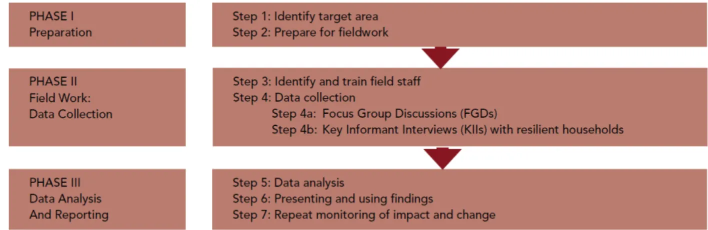
3.3 Resulting Assessment Methodology ... 46
iii
3.3.2 Phase 1: Needs Assessment and Preliminary Research ... 48
3.3.3 Phase 2: Design and Training ... 48
3.3.4 Phase 3: Group Assessments ... 50
3.3.5 Phase 4: Key Households Evaluation ... 51
3.3.6 Phase 5: Analysis and Distribution ... 53
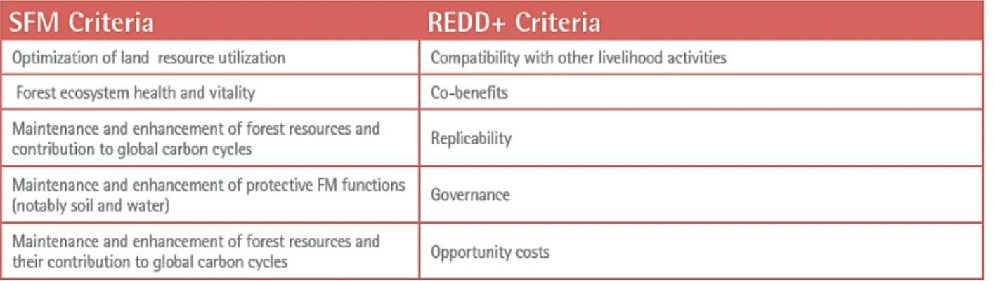
3.4 Indicators of Potential for REDD+ ... 53
3.5 Limits to the Analysis ... 57
4. RESULTS AND DISCUSSION ... 60
4.1 Santana’s State of Resilience... 60
4.1.1 Details on the Assessment Process ... 60
4.1.2 Community Definition ... 61
4.1.3 Vulnerabilities, Priorities and Achievements ... 63
4.1.4 Appreciation of Existing Services and Interventions... 66
4.1.5 Characteristics and Strategies of the more Resilient Households ... 67
4.1.6 Resilience Pathways ... 70 4.1.7 Overall Resilience ... 72 4.2 REDD+ Potential ... 72 4.2.1 Participation ... 72 4.2.2 Interest ... 73 4.2.3 Natural Capital ... 75
4.2.4 Similarity of Ongoing Activities to those Accepted by REDD+ ... 75
4.2.5 Overall REDD+ Potential ... 76
5. RECOMMANDATIONS ... 77
5.1 For Santana’s Resilience ... 77
5.1.1 Overcoming Vulnerability ... 77
iv
5.1.3 The End of the FASD ... 78
5.2 For a Successful Registration to REDD+ ... 79
5.2.1 Overcoming the Main Difficulties ... 79
5.2.2 Transitioning with the FASD ... 81
5.3 For Participative Conservation in General ... 82
5.3.1 Supporting Sustainable Environmental Responsibility... 82
5.3.2 Between Private and Public Management and Funding ... 82
5.4 For Corruption ... 83
CONCLUSION ... 85
REFERENCES ... 90
BIBLIOGRAPHY... 95
ANNEX 1: LAND USAGE AND COVER TYPES IN THE NIZAO WATERSHED ... 97
ANNEX 2: MAPS OF THE MAHOMITA SUBBASIN (Retrieved from MORN, 2018) ... 101
ANNEX 3: REDD+ POLICIES AND MEASURES (Retrieved from UNEP, 2017) ... 104
ANNEX 4: NATIONAL CRITERIA FOR SELECTING AN AREA TO BE REFORESTED (Retrieved from MARN, 2013) ... 105
ANNEX 5: FOCUS GROUP DISCUSSION FORM ... 107
ANNEX 6: KEY INFORMANT INTERVIEW FORM ... 112
ANNEX 7: CURRENT RESILIENCE CHARACTERISTICS EFFICIENCY ... 117
ANNEX 8: CURRENT RESILIENCE STRATEGIES EFFICIENCY ... 118
ANNEX 9: CURRENT RESILIENCE PATHWAYS MATRIX ... 119
ANNEX 10: ENGLISH EXECUTIVE SUMMARY ... 120
v LIST OF FIGURES AND TABLES
Figure 1.1 First implementation of FASD in three watersheds 15
Figure 2.1 Phases of REDD+ National Preparation 23
Figure 2.2 REDD+ Areas of Interventions 29
Figure 2.3 Key Attributes of Agroforestry Projects for REDD+ 32
Figure 3.1 Phases of a Social-ecological System 37
Figure 3.2 Phases and Steps in Undertaking a CoBRA Assessment 44
Figure 3.3 Phases of the Resulting Resilience Assessment 47
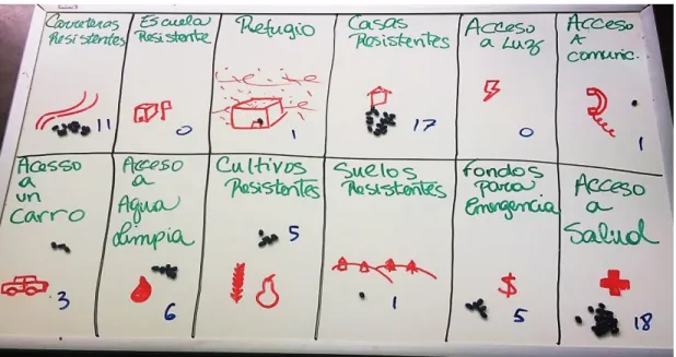
Figure 3.4 Votes on Local Climate Resilience Building Priorities during the Second
FGD 51
Figure 4.1 Santana’s Boundaries and Content as Described during the Second FGD 62
Figure A1.1 Life Zones in the Watershed 101
Figure A1.2 Land Cover Types in the Watershed 102
Figure A1.3 Protected Areas in the Watershed 103
Figure A1.4 Usage Conflict of the Soil in the Watershed 104
Figure A2.1 Location of the Mahomita Subbasin in the Country, with Relative
Position to San Cristobal and Santo Domingo 105
Figure A2.2 Hydrology, Villages and Roads in the Mahomita Subbasin 106
Figure A2.3 Land Cover Types in the Mahomita Subbasin 107
Table 1.1 Statistics on Los Cacaos and Santana 9
Table 2.1 Strategic Options and Related Actions for the National REDD+ Strategy 26
Table 3.1 Objectives of the Interviews and Related Questions 52
Table 3.2 Source of Data for REDD+ Potential Indicators 55
Table 4.1 Vulnerabilities of Capitals after the Passage of Hurricane Noel as
vi
Table 4.2 Prioritized Resilience Characteristics and Level of Achievement in the
Last 5 Years 65
Table 4.3 Example of Calculation of Characteristic Efficiency for Good House 68 Table 4.4 Example of Efficiency Calculation for the Resilience Strategy of
Secondary Studies 69
Table 4.5 Mentioned Resilience Preventing Factors and Underlying Resilience
vii LIST OF ACRONYMS, SYMBOLS AND INITIALS
AM Adaptive Management
ASOCAES Asocición de Caficultores la Esperanza
CAASD Corporacion de Acueductos Y Alcantarillado de Santo Domingo (Water Supply
Corporation and Aqueduct and Sewer Corporation of Santo Domingo)
CAS Complex adaptive system
CEDAF Centro para el Desarrollo Agropecuario y Forestal (Centre for the development
of agriculture and forestry)
CC Climate change
CoBRA Community-Based Resilience Analysis DFD Deforestation and forest degradation
DR Dominican Republic
DOP Dominican pesos (in 2018, 1 Canadian dollar was worth 38.5 DOP)
ECORED Red Nacional de Apoyo Empresarial a la Proteccién Ambiental (The National
Network of Business Support for Environmental Protection)
FASD Fondo Agua Santo Domingo
FCPF Fondo Cooperativo para el Carbono de los Bosques
FGD Focus Group Discussion
gha Global hectare
GHG Greenhouse gas
ha Hectare (10,000 m2)
HDI Human Development Index
KII Key informant interview
LAC Latin American and the Caribbean
LAWFP Latin American Water Funds Partnership
MMARN Ministerio de Medio Ambiente y Recursos Naturales (Ministry of Environment
viii
NDS National Development Strategy
ONE Oficina Nacional de Estadísticas (National Office of Statistics of the Dominican
Republic)
$PPP Purchasing power parity constant of 2011
RA Resilience Alliance
REDD+ Reducing emissions from deforestation and forest degradation and the role of conservation, sustainable management of forests and enhancement of forest carbon stocks in developing countries (United Nations Framework Convention on Climate Change [UNFCCC], 2008)
SRC Stockholm Resilience Centre
SES Social-ecological system
SLF Sustainable Livelihoods Framework
TNC The Nature Conservancy
UN United Nations
UNDP United Nations Development Programme
UNEP United Nations Environment Programme
ix LEXICON
Absorptive capacity How a community reacts to a direct shock.
Adaptive capacity “Systems with high adaptive capacity are more able to re-configure without significant changes in crucial functions or declines in ecosystem services. A consequence of a loss of adaptive capacity, is loss of opportunity and constrained options during periods of reorganization and renewal.” (Resilience Alliance, n.d.)
Adaptive management “Adaptive management identifies uncertainties, and then establishes methodologies to test hypotheses concerning those uncertainties. It uses management as a tool not only to change the system, but as a tool to learn about the system.” (Resilience Alliance, n.d.)
Bioregion “Bioregions are relatively large land areas characterized by broad, landscape-scale natural features and environmental processes that influence the functions of entire ecosystems.” (Office of Environment & Heritage, 2016)
Complex adaptive systems “A complex adaptive systems approach means stepping away from reductionist thinking and accepting that within a social-ecological system, several connections are occurring at the same time on different levels. Furthermore, complexity thinking means accepting unpredictability and uncertainty, and acknowledging a multitude of perspectives.” (Biggs et al., 2014)
Fiscal policies and incentives “The ways in which governments use taxes and government revenue to incentivize or penalize certain actions or behaviours.” (United Nations Environment Programme, 2017)
Geologic time scale A time scale relative to Earth’s history since its formation. Mental model “Cognitive structures upon which reasoning, decision-making and
behaviour are based.” (Biggs et al., 2014)
Nepotism The unfair use of power in order to get jobs or other benefits for your family or friends (Collins Dictionary, 2018).
Parnarchy “All systems […] exist and function at multiple scales of space, time and social organization, and the interactions across scales are fundamentally important in determining the dynamics of the system at any particular focal scale. This interacting set of hierarchically structured scales has been termed a panarchy.” (Resilience Alliance, n.d.)
Social-ecological system “Social-ecological systems are complex, integrated systems in which humans are part of nature.” (Resilience Alliance, n.d.) Transformative capacity The capacity of a system to change at system scale
x
Weatherable That can be degraded by weather.
Life zone Similar to the concept of biome, an area with similar plant and animal communities, specified by its latitude, altitude and humidity (McColl, 2005).
1 INTRODUCTION
The increasing concentration of greenhouse gases (GHG) in the atmosphere is capturing more and more solar radiation on the planet, and this increased global energy balance causes climate change. The effects associated to changes in climate patterns may be slow in some locations. They may not be felt, and the need to adapt or to fight these changes may not feel urgent or even be considered. In Dominican Republic (DR), climate change adaptation is implemented in the most important national development strategy. The effects are particularly felt by the damages caused by hurricanes. Hurricanes and tropical storms are natural local phenomenon, but both have increased in wind speed and duration over the last 30 years (Emanuel, 2006). Mitigating the mechanisms responsible for their formation, namely a warm ocean surface temperature and a moist layer in the troposphere (National Oceanic & Atmospheric Administration, 2014), demands a lot of theoretical and practical knowledge, and requires the capacities to act on the global scale and to coordinate with other mitigating actions. Simply put, to reduce the energy absorbed by the atmosphere, the concentration of GHG needs to diminish. The reduction of GHG emissions is widely discussed as a solution to stabilize the concentration, but gases also need to be sequestrated to be able to return to a less disturbed climate state.
Reduction and sequestration prove to be particularly difficult for countries with fewer resources, especially if they are vulnerable to increasingly destructive phenomenon. The geographic position and the socio-economic condition of DR put it in a state of high vulnerability. Every year, hurricanes strike the country and cause infrastructural and human losses, and the scale is unpredictable. Because climate change (CC) can’t be reversed in the short term, resisting such events is part of adapting to their acknowledged presence. An enlarged approach to sustainable development based on the management of disruptive events at the scale of a social-ecological system is called resilience. Climate resilience incorporates the capacity to absorb a disturbance linked to CC to the capacity to evolve and transform to be able to cope with or even avoid these disturbances on the long term.
To reduce greenhouse gas emissions, to stock atmospheric carbon, and to empower poorer countries to act, a global solution has been elaborated by the United Nations Framework Convention on Climate Change eleven years ago: a program called Reducing Emissions from Deforestation and forest Degradation and the role of conservation, sustainable management of forests and enhancement of forest carbon stocks in developing countries, or REDD+. Studies have identified deforestation and forest degradation (DFD) as one of the main sources of GHG emissions. In fact, around 10% of net global GHG emissions have been identified to come from DFD. This takes into account the sequestration of carbon due to forest growth and
2
recovery. This highlights that restoration acts as a very important sink of atmospheric carbon. (UNEP, 2017) Since the REDD+ program provides the necessary resources to participate in its activities and because of the possibility to make profits in emerging carbon markets, the government of DR has decided to start developing its own national strategy.
Four years ago, the Ministerio de Medio Ambiente y Recursos Naturales (MMARN), the Ministry of Environment of DR, started procedures to concretize its participation to REDD+. One key aspect of nationally enabling the program is the establishment of a functional benefit sharing mechanism, from the donors to the implementers, with all the necessary management. This leads to the formulation of three primary objectives for this essay.
I. An ongoing conservation project managed by the Fondo Agua Santo Domingo (FASD) has the reputation to have excellent, fast, and cost-effective results. The MMARN is interested to know how a public-private partnership like the FASD is managed to create more efficient national natural resources management solutions. (P. Garcia Brito, pers. comm., May 21, 2018; C. Ortiz Rojas, pers. comm., November 3, 2017)
II. Since the FASD involves agroforestry, an activity compatible with the REDD+ program, the MMARN also wants to know what potential it holds to participate in REDD+. However, since the strategy is in its preparation phase, a methodology to evaluate the potential would need to be developed. (C. Ortiz Rojas, pers. comm., November 3, 2017)
III. Since the community involved in the conservation project, Santana, is very vulnerable to climate change, since the community has the responsibility to maintain the provision of an essential ecosystem service, namely access to water in the national capital, and since the FASD is a prototype that could be replicated, it seemed necessary to assess its climate resilience and inform the stakeholders of the results. A participatory assessment process would seize the opportunity to empower the community with new knowledge and engage discussions on how to develop sustainably.
This participatory assessment is necessary to reach those three objectives, but also serves an important secondary purpose. Concerns are expressed as if the current FASD project only has self-serving, donor-based ecological objectives, or if it also aims to improve Santana’s resilience. The essay also tries to answer this question and analyze how exactly the FASD takes part in the resilience of the community. The results should encourage stakeholders to add clear community development or well-being objectives to their activities. A vulnerable community hit by a sufficiently disturbing event can cause the loss of all previously done work (in this case water replenishment and reforestation), and it is in the interest of the durability of
3
the attainment of the objectives of the donors to build local resilience. Both the primary and secondary objectives should serve to design future projects, to help the orientation of the national REDD+ strategy, to protect the community from unfair treatment, to improve the quality of life of the participants, to develop CC adaptation strategies, and to help the long-term protection of the environment.
The essay is composed of five chapters. The presentation of the context surrounding the assessment serves to understand where the three primary objectives come from, and to answer to the first one. The context allows to understand what the social-ecological situation of the country is, as well as its governmental objectives. Then the mechanism of the FASD is explored in both its history and its implications for the community. The specific context of the community is also presented and serves as a base on which the assessment methodology will source its focus.
The complete mechanism of REDD+ follows and is explored in its international objectives, and strategy development processes. It serves to understand the national goals and challenges, the possible funding opportunities and the possible ways to evaluate the potential of a hypothetical registration. This also helps to reach the second primary objective.
The third chapter is the participatory assessment methodology. It presents the global theoretical framework of resilience, and an inspirational practical framework from the United Nations Development Programme. It is called Community Based Resilience Analysis, and it is specifically designed to empowerment the participants to react to natural disaster threats in a very vulnerable community. Based on the two frameworks and on REDD+ criteria, the resulting participatory resilience assessment’s methodology and its five phases are explained, along with how the results will be treated.
The results of the assessment are in two parts given they have to answer to two different objectives. The resilience results explain what the community’s own perception is of its composition as a social-ecological system, and what it is vulnerable to. It also led the participants to establish community resilience priorities, which are compared to permanent necessities. The characteristics of the households identified by focus groups as more resilient is then discussed to understand which capital can be attained and which resilience principles are the most needed to build local community resilience. The efficiency of the strategies responsible for those characteristics is then analyzed to confirm what is most needed in the community to build resilience. The last part of these results is a proposition on how each characteristic can be attained and, inversely, what would be the outcomes of each strategy. The resilience pathways are presented in a matrix along with the factors preventing local resilience building. The REDD+ potential results evaluate the interest
4
of the community for the program and its activities, the capacity of the community to participate in the program, and the current perception of the quality of the natural capital and its usages. The potential is also compared to criteria from other countries to assess the current activities’ compatibility to REDD+.
The last chapter is composed of four sets of recommendations coming from the literature, from the assessment’s participants, and from contributors to this essay. The first set is about resilience building in the community based on identified vulnerabilities, chosen priorities and found necessities. The second set concerns what is needed for a successful REDD+ registration based on the local potential. Questions about the end of the activities of the FASD are asked to discuss if a possible transition to REDD+ would be possible. The third set concerns general concerns on participative conservation project design, as on how to do fair and efficient decision-making to avoid resource loss and corruption. Since corruption has been mentioned throughout the assessment as one resilience preventing factor, the last set of recommendations proposes solutions on how to fight it in a systemic manner.
5 1. CONTEXT PRESENTATION
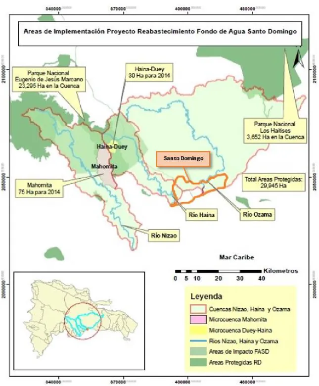
The chosen community for this assessment is called Santana de Benito, or simply Santana, and is situated in the subbasin of the river Mahomita, located in the northeastern part of the Nizao river watershed. Five years ago, The Latin American Water Funds Partnership (LAWFP) started the Fondo Agua Santo Domingo (FASD) to protect the bodies of water surrounding the capital, which have been degrading rapidly. Santana got involved with the FASD as a pilot for an upscalable recovery of the water resource, and a process to change the local practices related to agriculture, forest use and water management started.
1.1 Community Characteristics
Santana is part of the municipal district of Los Cacaos, in the province of San Cristóbal. Around 80 households, among which 39 participate in the Mahomita subbasin project, live there, most of them farmers, just south of the Loma Humeadora National Park. The community, though isolated and fairly unknown, is in ad equation with its national context and the following section covers how. The scale of the entire Nizao watershed has been chosen to represent its social-ecological characteristics as described below, as well as the pressures that influence it. Different maps of the watershed found in annex 1 are used throughout the following sections to illustrate land usage and cover types.
1.1.1 National Context and Strategies
The sovereign insular state of Dominican Republic (DR) has approximately 10.3 million inhabitants living on a 48,315 km2 territory, on the eastern side of the island of Hispaniola in the Greater Antilles archipelago of the Caribbean Sea (Oficina Nacional de Estadísticas [ONE], 2018). The only neighbouring country is Haiti, on the western side of the island. Its Human Development Index of 0.722 indicates that the country is in the high human development category, with a context comparable to the ones of El Salvador and Jamaica. In 2015, the life expectancy at birth was 73.7 years, the expected years of schooling were 13.2, and the Gross National Income per capita was 12,756 US$PPP. (United Nations Development Programme [UNDP], 2016)
The country has had one of the fastest economic growth in the Latin America and Caribbean (LAC) region for the last two decades, mainly driven by the construction, manufacturing, tourism, and mining sectors (The World Bank, 2018). As 80.6% of the population lives in cities, secondary and tertiary sectors make up for most of the economic activity. Actually, only 5.5% of the economic activity is related to the agricultural
6
sector. (Central Intelligence Agency, n.d.) The biocapacity and ecological footprint of the country have been stable since 1998, with a slight deficit of -1.0 gha per person, meaning that the domestic exploitation of resources expanded at the same rate as the population growth (Global Footprint Network, 2018). Even though 79.5% of the forest land cover changed usage since 1990 (UNDP, 2016), the rapid development is due to a dominant value of importations. It has been twice as much as the one of exports for the last eight years. Population growth increased urban sprawl and construction, which means more need for construction materials and land for food production. Even through this growth, 28.9% of the population still lives under the national general poverty line, meaning that inequities between the poorest and the richest citizens are growing as well. (ONE, 2018)
DR has been one of the first countries to finish a National Development Strategy (NDS) that integrates an economic development compatible with CC. In this regard, the government has ambitious visions for its forestry and agriculture sectors. It estimates that the forestry sector could be transformed into a net carbon sink because its current emissions are decreasing. At an estimated average cost of 4 USD/tCO2eq, sufficient efforts in afforestation, in reforestation, and in slowing down deforestation could lead to create 15,000 new jobs and to capture USD 35 million worth of carbon per year in 2030, mainly through international funds in the REDD+ program and the Clean Development Mechanism. (Consejo Nacional para el Cambio Climático y el Mecanismo de Desarrollo Limpio [CNCCMDL], 2011) The agriculture sector should be developed accordingly, but has not been identified as a priority. It has simply been acknowledged as one of the main sources of greenhouse gases (GHG) emissions and pollution in the country, with a will to act on it. Efforts are more concentrated in stopping agricultural sprawl and displacing small farmers for reforestation than democratizing the transition to sustainable practices. (CNCCMDL, 2011) Therefore, any project with a potential for those programs, like the one in Santana, may be of high interest for the state. The only problem with the national REDD+ strategy is that it may not be operational until 2020 (P. Garcia Brito, pers. comm., May 21, 2018).
1.1.2 Biogeophysical Characteristics of the Nizao and Mahomita Watersheds
The Nizao watershed consists of nine tributary subbasins in the mountainous area of the Cordillera Central and covers 1,039.84 km2. It is distributed over 10 municipalities in the southern part of the centre of the country, in the provinces of La Vega, Peravia, San Cristóbal and San José de Ocoa. It crosses seven life zones and two transition zones. These zones are illustrated in figure A1.1 of annex 1. 42% of the area is covered by super-humid tropical forest and humid subtropical forest, in climates varying between monsoon and oceanic. Precipitations are therefore abundant, ranging from 900 mm to 2000 mm annually, at altitudes
7
varying from 400 m to 2200 m. In the super-humid forest, the percentage of evapotranspired water is equal to the amount of rain that falls, which results in the channels of the streams carrying water only in the months of maximum precipitation. In the humid forest, potential evapotranspiration is estimated at 20% less than the total annual average precipitation. (Ministerio de Medio Ambiente y Recursos Naturales [MMARN], 2017a)
Agricultural use covers 31.87% of the land. This includes areas with intensively implemented annual crops, intensive crops, and subsistence agriculture, all mainly located in the lower areas. Perennial crops occupy 16.95% of the area, almost entirely composed of coffee, grown mostly in the middle part of the basin, in higher areas. The pasture area represents 15.84%, including intensive and natural pasture. Other coverings in the basin include savannah vegetation, urban areas, dams and lakes. Land cover types can be found in figure A1.2 of annex 1. The northeastern part of the basin is considered to contain a high level of vegetal endemism, and generally a high ecological value. In terms of protected areas which are shown in figure A1.3, 42.22% of the watershed is under the National System of Protected Area as national parks, scientific reserve and ecological corridor. The ministry of environment and natural resources considers that 47.28% of the area is not adequately used regarding productive capacity and actual usage, most of it being overutilized around the Mahomita River. (MMARN, 2017a) These considerations are shown in figure A1.4. The Mahomita subbasin has an area of 11,460.13 ha. The soils are suitable for forests, distinct by their stoniness, depth, and steep topography. (Segura, 2014; MMARN, 2017a) Still, conditions are perfect to grow coffee, which happens to be a great culture to hold soil. Indeed, coffee is a bush that needs the cover of taller trees which have deep roots. Ideally, coffee requires good drainage, an altitude between 550 m and 1,100 m (the Mahomita subbasin is between 300 m and 1300 m), and a temperature is between 15oC and 24oC (the subbasin has a mean annual one between 21oC and 24oC). (Centro para el Desarrollo Agropecuario y Forestal [CEDAF], 2014b; Diby, L., Kahia, J., Kouamé, C., and Aynekulu, E., 2017; MMARN, 2017a) The abundant rainfall also causes almost continuous flowering in coffee, which results in two harvesting seasons per year. (Coffee Research Institute, 2006)
1.1.3 Specific Social-ecological Context of Santana
For the following section, two maps of the Mahomita subbasin can be found in annex 2. They show the latest data gathered by the MMARN in 2012 regarding rivers, villages, roads and land cover type.
8
The village of Santana is part of the municipality of Los Cacaos. However, it is at least 25 km further down the meandering road. One needs to continue north of Los Cacaos where the paved road ends, through Calderon and other very small villages, before reaching Santana further in the mountains. It is also located at the very end of the dirt road, just after the village of Arroyo Grande, and both are in the Mahomita subbasin. The geographical conditions are very similar to the ones of the Nizao watershed presented earlier. Evapotranspiration is a bit different, which is about 60% less than the average precipitation, leading to the formation of streams all year long. The soils of this subbasin are mostly sandy loam, a condition that facilitates the erosive processes, with low content in organic matter and nitrogen, and with high content in potassium. (Segura, 2014)
The biggest difference is related to biodiversity, because few forest species constitute the natural arboreal vegetation locally. However, the Loma Humeadora National Park just north of Santana, has been declared a key point for the conservation of biodiversity by the Cooperation Fund of Critical Ecosystems, because it houses endemic species under various threat categories on the Red List of Endangered Species of the International Union for Conservation of Nature. In this regard, the potential usage of land for agroforestry is 4,286 ha. As for the rest, 5,148 ha are classified as a protected zone, and 565 ha for forest use. (Segura, 2014) In terms of biological threats, no snake, spider or big mammals threaten agricultural activities. The only two issues mentioned by the locals were the sometimes abundant mosquitoes and two easily identified plants that cause very short skin rashes.
Agriculture is the basis of the economic activities, especially coffee and livestock. The agriculture is not organic, but given the lack of resources and poverty, people have very little access to fertilizers and pesticides. (Segura, 2014; G. Morales, pers. comm., May 11, 2018) The extraction of wood in the area is not very popular, as only 4% of the inhabitants of Santana carried out this activity to expand the agricultural land (CEDAF, 2014a). According to the 2002 census, 49.9% of the homes of the Province of San Cristóbal are considered poor, and, of these, 1,422 are in the municipality of Los Cacaos. The Mahomita Basin has the highest percentage of poverty of the municipality, at 81.8%. (Segura, 2014) During a workshop given by the CEDAF, all attendees mentioned that their favourite activity was agriculture, and that they all loved very much the environment they lived in. All skills related to agriculture are taught by parents to their children through work and rarely come from outside or from specific studies. (R. B. Geronimo, pers. comm., June 26, 2018)
9
As multiple social studies have been conducted on varying scales in the area, the statistics on Santana are presented in the following table 1.1, sometimes as a part of Los Cacaos and other times joined with Arroyo Grande.
Table 1.1 Statistics on Santana (Retrieved from: CEDAF, 2014a; ONE, 2016) Living Conditions
Households made of precarious, mostly organic materials
74%
Households with electricity supply All those surveyed have electric power from the power line
Households with access to means of transport 59%
Population using wood for cooking 88%
Population receiving drinking water as a service 60%
(18% of this water comes from wells or aqueducts, and 57% comes from streams or ponds) Technology and Communication
Households with a mobile phone or landline 46.6%
Households with a computer 4.2%
Households with an internet connection 0.9%
Households with radio and/or television 58%
Education
Population that completed primary education 65%
Illiteracy rate 27.9%
“It is rare to encounter people that can read or write” (G. Morales, pers. comm., May 11, 2018) Economic Activity
Economically active population 63%, of which 73% is engaged in agricultural work, 12% to trade and 15% to other activities
10
Economic Activity
Average Monthly Income 5,000 DOP
Population considered able to work 79.2%
Spending priorities Food, health and education
Health
Population reporting a permanent limitation 6%
Population reporting diseases 35%
Political Activity & Gender Average population participating to municipal
and national elections
75.1%
Women elected officials 42.9%
Community members who think that women have had the same opportunities
86%
Community members who consider women are at a disadvantage
65%
Violence Number of reported suicide, traffic accident,
drowning or electrocution in 2014
0
Number of reported homicides in 2014 1
Land & Natural Resources
Population with owned lands or entitlement 50%
Population that manages natural resources on their lands
9%
Population with crops affected by plague 54%
(31% use pest control methods) Population that received agricultural technical
assistance
34%
11
In terms of participation to the activities of the FASD, most people in Santana are motivated and are used to visits from stakeholders of the project (G. Morales, pers. comm., May 11, 2018). As an example, 57% of them have participated in the reforestation campaigns from 2013, and 53% of agricultural producers carry out conservation work within their farms. Also, 85% of them understand that the productive capacity of their soils has decreased in recent years and that conservation actions are needed. (CEDAF, 2014a)
The most important local institution is the Asociación de Caficultores la Esperanza (ASOCAES). Its creation was triggered by the need to unify in the face of massive culture loss after the passage of hurricane David in 1979. It now regroups more than 600 members across many communities close to Los Cacaos. In Santana, 16 households are members. The coffee is all processed in Los cacaos, from where it is mostly shipped across the region of San Cristobal, but also in Santo Domingo and to a few international buyers. Since coffee production is so important in Santana, the ASOCAES acts as the entry point of external initiatives and key facilitator of development for the community. A few other social groups exist: common monetary savings, the church, and school committees. (R. B. Geronimo, pers. comm., June 26, 2018) As for future planning, the need to create a local entity responsible for the representation of Santana in Los Cacaos independent from the ASOCAES has been mentioned by many and may happen in the following years. However, the aging population and constant poverty worry the leaders about what the future holds for Santana as many families now try to send their children away from the village in hope of giving them more successful opportunities. (R. B. Geronimo, pers. comm., June 26, 2018)
1.1.4 Pressures
The global and national population growth, expected to peak domestically around 2050, will increase the pressure on forests and agricultural lands with a bigger demand for food, infrastructure, and energy (Department of Economic and Social Affairs of the United Nations [DESA], 2015). Increased productivity on existing cropland will account for some of the supply, but the expansion of agriculture will continue to be a major driver of forest loss. The global demand for wood products, mainly for furniture and construction, is likely to come from tropical developing countries. It is thought that illegal domestic wood trade will increase, unless concerned countries on both sides of the trade improve their law enforcement capacities. (United Nations Environment Programme [UNEP], 2017) Since the energy produced in the country is not available everywhere, is expensive, is only sourced at 13.2% from renewables, and the government identified the energy sector has the most emitting of GHG, the demand for biofuels is likely to increase
12
(CNCCMDL, 2011; UNDP, 2016). In the Nizao watershed, the main pressures on forest loss are also for wood trade, agricultural expansion, and charcoal production (G. Morales, pers. comm., May 11, 2018). The geographical localization of Hispaniola puts the DR in a particularly vulnerable situation regarding CC. While Haiti has been among the three most affected countries in the world since 1996, DR is in the eleventh place according to Global Climate Risk Index (Kreft, Eckstein and Melchior, 2017). By 2050, the average annual temperature is expected to increase by 1oC to 2oC, resulting in intensified hydrological cycling. Extreme weather events are also more likely to happen by 30% between May and October. After 2050, the drought season (December to April) may intensify, as the total annual rainfall should decrease by 15%, especially in the provinces of the South and West, where Santana is situated. Moreover, the existence and increase of several vector-borne diseases, such as Zika, chikungunya and dengue, are to be expected due to the change in temperature and precipitation. Therefore, adaptation measures have become a priority for the government since 2011 in their latest NDS. Even if the number of actions is multiplying, concrete results may not be expected soon since the NDS and National Climate Change Adaptation Plan aim to finish the related studies, plans, policies and laws by 2030. (MMARN, 2017c) Since much of the funding to put this in place is international and goes to government-related organizations, the numerous political intentions lack the necessary resources and embodiment means for large-scale implementation.
Concerning the Mahomita subbasin, it presents serious conditions of deterioration. The main factors that cause degradation in this area are the steep slopes, the erosion caused by rain, weatherable rocks highly productive of sands, actions of deforestation, construction of roads without adequate requirements and bad agricultural practices (CEDAF, 2014b). The community is also at risk of natural hazards. Luckily, landslide, volcano eruption and extreme heat are at no to low risk according to the Global Facility for Disaster Reduction and Recovery. River flood, coastal flood, earthquake and water scarcity are at medium risk, which means that any project planning, design, and construction should take into account the risk in the upcoming 10 years. (Global Facility for Disaster Reduction and Recovery [GFDRR], 2017) Regarding access to water, however, there is an inherent water stress all over the country, particularly related to human consumption. In the subbasin it is due to increasingly persistent droughts (rise in temperature), difficult access to a potable supply (lack of infrastructure), loss of water bodies (sedimentation), and unsustainable agricultural practices (sedimentation and pollution). (MMARN, 2017c) Urban flood, cyclone, and wildfire are at high levels, meaning there is a greater than 50% chance of encountering a hazard likely to result in both life and property loss in any given year (GFDRR, 2017).
13
The last pressure has been recurrently mentioned by FASD stakeholders and by the participants and collaborators of this research. The issue is present everywhere in the country: corruption. According to surveys conducted by Transparency International, Dominican Republic is the second most corrupted country in the LAC region, just after Mexico. Actually, the survey asked if, in the last year, they had to provide a bribe, gift or favour to a school representative, health worker, police officer, court official or government official in order to get a document or to receive basic services, and 46% of the respondents said yes. (Transparency International, 2017) The state of corruption in the country is hard to quantify or even to discuss, as “weak enforcement mechanisms and a lack of political will to prosecute criminals, particularly high-level public officials, are the primary barriers to effective investigations” (International Trade Administration [ITA], 2017). Corruption is also hard to fight as it grows where power and money are. While these may not concern the people of Santana, the stakeholders of the FASD and, with certainty, the results of the assessment in the following chapters, here are some of the negative impacts mentioned throughout the research:
Slowed political processes;
Expansion of social divide;
Inefficient funding allocation;
Lack of consistency with objectives and decisions, and possibility of evaded obligations through bribes;
Lack of serious in work and unnecessary efforts spent on appearances;
Favoritism, missed opportunities and instability of employment;
Violence, intimidation, fear or obligation to act;
And fear to denounce.
(K. Rodriguez, pers. comm., May 16, 2018; G. Morales, pers. comm., May 11, 2018; C. Ortiz, pers. comm., May 21, 2018; M. Rodriguez, pers. comm., May 19, 2018; L. Solano, pers. comm., May 11, 2018; L. Rojas, pers. comm., May 27, 2018)
1.2 Microcuenca Mahomita Project History
The main problem driving the project in the Mahomita subbasin is the degradation of soils by erosion, which has been made evident by the sedimentation state of the Aguacate reservoir and the output of the Aguacate hydroelectric power plant, and by the decreasing availability of water in all human settlement dependent on the Nizao watershed, including the capital Santo Domingo. It has been decided to implement targeted actions for the restoration of ecosystems, so that erosion levels and the consequent sedimentation of hydraulic infrastructures can be reduced. (CEDAF, 2014b)
14 1.2.1 Project Initiation
The demand for water has greatly increased in the last 20 years in Santo Domingo, and the city is home to almost the third of the national population. The infrastructures necessary to treat residual waters didn’t follow the city’s expansion, leading to the contamination of its underground potable water sources. The demand in energy also inevitably increased, but the sedimentation coming from forest loss, soil loss, and from excessive aggregate extraction for construction or granules has been reducing the capacity of reservoirs and clogging the intake grid by up to 40% on four neighbouring hydroelectric dams, therefore decreasing their productivity. Frequent failures to comply with current legislation has also contributed to the elimination of wetlands and some aquatic and terrestrial fauna. The bodies of water around the city present alarming levels of degradation, to the point that they have been classified as priorities for the ordering of natural resources, as they are essential to boost the socio-economic and cultural development of the country. (Díaz González and Florián, 2011; G. Morales, pers. comm., May 11, 2018; Segura, 2014) In view of this complex situation, the international environmental nonprofit The Nature Conservancy (TNC) decided to find a way to implement a sustainable solution. Through the Latin American Water Funds Partnership initiative, the Fondo Agua Santo Domingo (FASD) was created to initiate the work, naming the Centro para
el Desarrollo Agropecuario y Forestal (CEDAF), an important Dominican research institute, the
organization responsible for the implementation. (G. Morales, pers. comm., May 11, 2018) The governance of the FASD and the management of its operations will be covered in section 1.3.
As seen in figure 1.1, three rivers provide hydroelectricity and clean water to Santo Domingo: Ozama, Haina, and Nizao. The later one supplies more than 30% of Santo Domingo’s water consumption, represents a hydroelectric generation potential of around 200 MW, and a source of more than 50% of the national aggregate production for construction (Díaz González and Florián, 2011). Therefore, since its launch in 2013, the main objective of the partners of the FASD has been:
“to improve the health of ecosystems and water producers, as well as to reduce the inputs of sediment to the reservoirs to ensure the availability of water in sufficient quantity and quality to users, taking into account the potential impacts climate change, while increasing forest cover by restoring the ecosystems with the consequent benefit to preserve the country’s biological diversity.”
(Latin American Water Funds Partnership [LAWFP], 2017a)
The Mahomita subbasin has been prioritized among three sites after two comparative socio-economic and hydrological studies. Its good short term potential for reforestation was reinforced because many local farmers were already engaged in agriculture under forest cover, and because the river is one of the highest and biggest tributaries to the Nizao River. The subbasin would be a pilot, used as a model for areas where the FASD or another initiative could act in the future. (Segura, 2014; D. R. Brito, pers. comm., May 16,
15
2018; C. Garcia, pers. comm., June 19, 2018) Since the very beginning, the strategy and activities of the project have been planned by the CEDAF and the FASD alone as direct propositions to the community. The community received all offers positively as the project was following local values held by many: give care to nature and fight poverty. (R. B. Geronimo, pers. comm., June 26, 2018)
16 1.2.2 Current State
Between 2013 and 2014, the activities of the FASD have been to gather the partners and to determine a site to start a project. This included various social, economic, biological and geophysical studies throughout the whole Nizao watershed, and the creation of various monitoring protocols. Once the Mahomita subbasin was identified as the most pertinent starting point in 2014, other studies were conducted locally, a partnership was established with the ASOCAES, a local association of coffee producers from the Mahomita subbasin, and the participative conservation project started. Two communities were chosen in this subbasin for the implementation: Arroyo Grande, and Santana. (CEDAF, 2018; G. Morales, pers. comm., May 11, 2018; Segura, 2014)
Up until November 2015, conservation actions included reforestation with coffee and native plants systems. Plot owners have also been encouraged to plant banana along with coffee plantations to prevent soil deterioration while coffee is growing. These activities prevented the continuation of the common practice of burning and planting, Quema, in higher and more isolated regions. In February 2016, an evaluation concluded that more than half seedlings had died. This triggered TNC, Coca-Cola and Bepensa to make bigger efforts to insure a replenishment of the aquifers in the subbasin, as well as improve the local socio-economic state of the participating communities. This gave birth to the current ongoing project, named Replenishment of water in the Mahomita subbasin, with a new strategy for the maintenance of plots and replacement of seedlings. It should guarantee the permanence of the forest cover and the commitment of the farmers to maintain practices that support productivity, better income and sustainability. Up until now, the project involved 39 community farmer plots throughout the subbasin, provided assistance for the maintenance of their lands and the replacement of the dead seedlings, and helped with soil conservation, reforestation, and riparian ecological restoration. (CEDAF, 2018; G. Morales, pers. comm., May 11, 2018) The first phase of the project is to carry out the pilot hydrological and forest recovery activities. With the agreement of the FASD, the CEDAF decided on four. The first is the conservation of native forest, which is intended to protect still intact wooded as the local economic stress tends to change the use of land with subsistence cultivation. The second is the assisted reforestation with native and endemic species of coniferous and hardwood in areas suitable. The third activity is the rehabilitation of coffee plantations, as the main activity in the area is growing coffee. It incentivizes the participation of the communities because, in recent years, the plant has been attacked by pests (Roya “coffee rust” Hemileia vastatrix, and Broca “coffee borer beetle” Hypothenemus hampei), which have led the owners to replace coffee plantations with crops of short cycles that don’t have the same soil stabilization capacities, namely because they don’t require
17
forest cover. Therefore, the CEDAF introduced two varieties of coffee resistant to the mentioned pests and that could grow in high altitude under shade: Costa Rican Catimor and Colombian Lempira. These varieties also yield results from a first harvest only 1.5 years after it has been planted, instead of three years like its predecessor. The last activity is the restoration of riparian corridors. Its purpose is to protect and strengthen the banks of the rivers, with an average strip width of 30 m around the bodies of water. (CEDAF, 2014b; G. Morales, pers. comm., May 11, 2018) To ensure the long-term quality of the results, the CEDAF has also been capacitating the inhabitants of the Mahomita subbasin, which is concretized in continuous accompaniment, and training and workshops related to good practices in soil and water conservation, management of environmental issues related to local economic and conservation activities, the importance of protected areas, CC, ecosystem-based adaptation, good agricultural practices, solid waste management, and the management of pests. (CEDAF, 2018; V. A. Matias, email, May 15, 2018)
This second phase started in 2017 after the pilot was confirmed successful. It is about the maintenance of the plots of the subbasin, and the expansion of the activities. The two phases are more complimentary than subsequent. This one also serves to monitor and adapt in order to conduct relevant activities. The aim for September 2018 is to have involved 769 people directly and indirectly, through conservation actions and workshops, and to have had an impact on 171.47 ha of land. As of now, there is no planned end to the project. In fact, the current commitment of Bepensa and Coca-Cola is to finance the activities until the replenishment of the groundwater will be as big as their yearly use. This commitment is estimated to end in 2020 but may be renewed indefinitely. There is no planned major upscaling or reproducing the project elsewhere. The Mahomita site along with the two others from the FASD will continue to grow slowly in cycles of participant recruitments, land acquisition, technical assistance and replenishment monitoring until Bepensa and Coca-Cola reach their goal and decide to stop the financing. (CEDAF, 2018; G. Morales, pers. comm., May 11, 2018; C. Garcia, pers. comm., June 19, 2018)
1.3 Governance
The Microcuanca Mahomita project has stakeholders on four different scales: international and national for funding; and national, regional, and local for planning, managing and implementing. All partners in the FASD have different roles and consequently need to report their activities to the others. The efforts needed to implement effectively this project are big, and require a close collaboration, from the international organization that monitors CC to the farmer who will be planting new trees.
18 1.3.1 Responsibilities of Project Initiators and Managers
The LAWFP is managed by TNC, as a means of gathering funds for the specific goal of preserving lands above watersheds through conservation actions in Latin America. The LAWFP creates localized partnerships, like the FASD, to gather local stakeholders from the public, private and NGO sectors, and provide them with technical and financial support to implement conservation projects. The funding of the LAWFP is done by TNC, The Inter-American Development Bank, the Global Environmental Facility, and the Femsa Foundation, which is mainly related to The Coca-Cola Company, fuel distributors and car manufacturers.
The funding of the FASD comes from the private sector: Coca-Cola and its bottling company in Dominican Republic, Bepensa, the vice-president of the partnership. These two partners decided to commit to a financial participation until a specific groundwater replenishment is reached in total for the three sites: 561,555 m3 of water per year. This volume is equivalent to what Coca-Cola will use in 2020 for its activities in Dominican Republic. Other partners of the assembly include:
TNC, the representative of the partnership and link with the LAWFP;
The National Network of Business Support for Environmental Protection (ECORED), president or the assembly;
The Water Supply Corporation and Aqueduct and Sewer Corporation of Santo Domingo (CAASD), secretary of the assembly and public sector representative;
The Fundación Universitaria Dominicana Pedro Henríquez Ureña, an academic NGO;
The PROPAGAS group, a private distributor of hydrocarbons who helps with the financing and the visibility of the partnership;
The CEDAF;
The Pro Nature Fund PRONATURA, an NGO responsible for the implementation in the two other sites (Haina and Duey);
Agroforsa, a sustainable development project implementation private firm;
The Ministry of Environment and Natural Resources (MMARN);
And the ASOCAES. (C. Garcia, pers. comm., June 19, 2018; LAWFP, 2017b)
Decisions regarding vision, politics and strategies are taken yearly in assemblies. An external audit is done to certify financial accountability. A yearly report is also discussed. As of now, it is believed that results are better than expected in terms of the replenished volume of water. (C. Garcia, pers. comm., June 19, 2018)
19
As previously mentioned, the CEDAF is the main responsible for planning and managing the implementation, in close collaboration with the ASOCAES. The CEDAF receives its resources through TNC and reports to them. TNC then reports to the other involved partners of the FASD through the Latin American Water Funds Partnership portal. (J. Segura, email, May 14, 2018) The CEDAF is responsible for land acquisition for conservation, making contracts of 5 years of conservation with farmers agreeing to share a part of their land, provide technical assistance to participating farmers as part of the contract, and coordinate all the field activities. The CEDAF also does the monitoring of the progress for the FASD: the impacted area by type of activity, the participation (directly and indirectly impacted people, number of beneficiaries, and number of workshops provided), and the volume of replenished water (through soil infiltration, forest cover and climate monitoring). (C. Garcia, pers. comm., June 19, 2018)
The MMARN has also been involved in the project as a partner, but has not been assigned a specific role to make the project happen like the others. Since 2000, the national Law 64-00 recognizes environmental services and the need to create mechanisms, norms, methodologies and procedures to manage them. It empowered the MMARN to create mechanisms to finance operations related to the environment, to distribute the benefits, and to sell and charge environmental services to direct beneficiaries or users, therefore facilitating the involvement of the private sector in the management of natural resources. (Díaz González and Florián, 2011; P. Garcia Brito, pers. comm., May 21, 2018) Since some of the stakeholders related to the FASD, namely Coca-Cola, use water as an important resource for their activities, the MMARN influenced their financial participation, and provided technical assistance in the first years. (D. R. Brito, pers. comm., May 16, 2018)
The public sector is not very much involved in the FASD. Currently it is only being represented by the CAASD because the MMARN has stopped its participation two years ago with the change of government. It has been confirmed it is not a choice to avoid inefficient resource allocation because of the well-known problem of corruption, but because the public water management sector in Dominican Republic is very small. Water management is both the responsibility of the private and public sectors, and the FASD is seen has a space to proceed for the harmonization of objectives. (C. Garcia, pers. comm., June 19, 2018) 1.3.2 Responsibilities in the Community
Certain activities are conducted only by the CEDAF, others only by the community, and some others are done together. Land acquisition and native forest conservation are done by the CEDAF alone. However, the human resources needed are hired locally and only one or two technical specialists are sent to overview the
20
progress. The maintenance and establishment of coffee plantations are done only by the community members. Assisted restoration of forest and riparian corridors is done together, as well as the conduction of workshops. Both are organized with the ASOCAES. (CEDAF, 2018)
To facilitate the autonomous involvement of the community, the CEDAF gives the farmers everything they need to produce coffee: plants, soil, and fertilizers. Since reforestation is done on each participating parcel, the management of a portion of the parcel is given to the CEDAF in exchange for the necessary resources to plant coffee. Since the land belongs to community members, the CEDAF plans the allocation with the beneficiary. Additionally, the new coffee plantations must be planted under shade to guarantee an increase in vegetation cover. (G. Morales, pers. comm., May 11, 2018)
21 2. THE NATIONAL REDD+ STRATEGY
The MMARN is interested in many aspects of the FASD regarding the upcoming national REDD+ strategy. It first wants to understand its mechanism to establish results—based payments, which is one of the biggest challenges with for REDD+ program. It would also like to determine how to link the REDD+ mechanism to the FASD, as it would facilitate the implementation process, which is another big challenge for the REDD+ program. Since the activities in Santana are related to reforestation and agroforestry production, it is also a potential model that could be reproduced in other communities as a profitable carbon sequestration model for REDD+ solutions around the country. As an entire other analysis of a much bigger scale would be required to come to these conclusions, this essay only partially answers those questions. While the context does respond to how FASD works (it is not result-based), the assessment verifies the potential for the project in Santana to register to the national REDD+ strategy.
The REDD+ program and registration process will therefore be presented from the international to the local scale, along with models from Zambia and Peru before discussing the probable challenges. The REDD+ potential assessment will be presented in chapter 3, the methodology.
2.1 Presentation of the REDD+ Program
The UNFCCC launched a program called Reducing Emissions from Deforestation and forest Degradation and the role of conservation, sustainable management of forests and enhancement of forest carbon stocks in developing countries (REDD+) with the objective to reduce GHG emissions, to fight CC, and to offer to developing countries the opportunity to review the management of their forest ecosystems. Simply put, REDD+ creates a system to finance initiatives and rewards projects according to their results. These may be related to:
Reducing emissions from deforestation and forest degradation;
Sustainable forest management;
Conservation, sustainable management and enhancement of forest carbon stocks.
Each country participating in the program develops a personalized strategy and creates action plans for priority areas. “The design of support distribution and project implementation are influenced by a country’s forest cover, governance scenario, stakeholder relations, and funding contexts” (Enrici and Hubacek, 2018). Projects are created with local implementers and various assessments are done to calculate potential benefits. The projects put in place also have the side opportunity to register in voluntary carbon markets to increase the benefits of their efforts.
22
In theory, it may look like a panacea for developing countries. REDD+ is a holistic solution that ensures intertwined sustainable resource management and economic development, which are consistently in conflict across the globalized world. REDD+ is not limited to the ecological aspects of fighting CC, it also addresses the economic and social development of participating countries and communities involved in projects. However, skepticism about REDD+ has developed since the beginning because of the numerous challenges related to the implementation of such a complex and integrated initiative (Enrici and Hubacek, 2018). The REDD+ program is tremendously complex, particularly because it must be integrated in almost all ministries of a country, because the benefit sharing mechanism is complicated to adapt fairly to all projects, and because the number of stakeholders and steps to reach an actual result-based payment are numerous. While these can be determined in the strategy through years of discussions and negotiations, the actual implementation is still to be done and may also present numerous challenges. The commercialization of forest ecosystems through carbon markets actually presents challenges along the whole chain of operations, starting from the pollutants that want to offset their emissions, all the way to the project implementers, passing by international organizations like the World Bank, a national committee and a subregional entity. Therefore REDD+ may not be the best solution to all the problems it is trying to tackle because, even after 11 years of activity, the results are hard to grasp for the participants and the process is still slow. On the CC point of view, the program proves to be relatively efficient, as it has materialized in 29 countries and, to date, has been the largest international conservation effort ever made. (Enrici and Hubacek, 2018; Mwangi, 2015)
At the MMARN, the development of the REDD+ National Strategy is the project with the most employees in the climate change department. As it has been mentioned in chapter 1, there may be a lot of potential benefits to be made with carbon sequestrations through international financing programs and it is why the MMARN is so interested in having its strategy done and active as soon as possible.
The adoption of a national strategy takes place in three phases: preparation (readiness), implementation and actions. The description of these phases can be found in the figure 2.1. The process is adaptively managed in cyclical steps. The first is the identification of drivers of deforestation and forest degradation (DFD). The second is to develop the drafts of the founding documents, namely the national strategy, the national forest monitoring system, the safeguards approach and information reporting systems, and the reference levels of forests and emissions. These documents are sent to the UNFCCC for technical evaluation. Then, the country implements the policies and measures of the national strategy. Summaries of safeguards information are joined to the National Communication, as well as the technical annexes of the updated biennial reports. The