Past landslides in the Verviers (E Belgium) area:
climate- or earthquake-induced features?
Alain Demoulin, Albert Pissart
Dept of Physical Geography and Quaternary University of Liège
Sart Tilman, BU, B-4000 Liège
KEYWORDS: Belgium, Hockai fault zone, landslide.
ABSTRACT
A number of great past landslides are described in the Battice area, to the north of Verviers (E Belgium).
With the exception of two minor forms, all these landslides concentrate around the northern extension of the Hockai fault zone, corresponding to the eastern limit of the La Minerie graben.
They mostly displace the predominantly clayey Vaals formation (upper Cretaceous).
Geophysical exploration as well as the excavation of several trenches revealed the complex character of the landslides, comprised of multiple slumped masses.
C14 dating showed that a first sliding event was recorded in both analyzed sites at ~100 AD. Three later reactivations are also locally evidenced at ~400, 700 and 1250 AD.
Moreover, some sites are still very sensitive to present-day heavy rainfall periods. As the geophysics demonstrated that the slip surface of several rotated masses extended down to the underlying Aachen sands, it is probable that liquefaction of the latter was the main cause of the slides. Provided the first obtained C14 date corresponds to the slide initiation time, it cannot be clearly related to any known landslide-prone period in NW Europe.
Therefore, in spite of lacking definite evidence, the particular location of the Battice landslides suggests one should also give consideration to a possible seismic triggering.
1. Location and description of the landslides
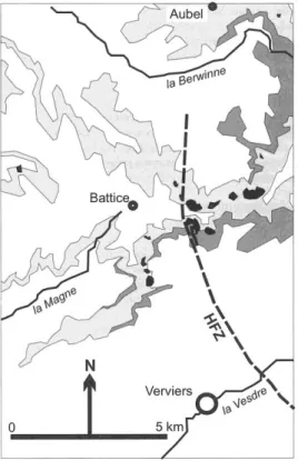
About 10 large landslides are observed in the Battice area, to the north of Verviers (E Belgium). They are located on the slopes of the main ~E-W trending ridge of Battice – Henri-Chapelle and of a secondary ridge extending southward in the direction of Verviers (Fig. 1). Slope angle is generally comprised between 10 and 15°.
Figure 1. Location of the Battice landslides. The light grey area corresponds to the outcropping Vaals
formation, the dark grey area to the Aachen formation. Landslides appear in black. The solid line denotes a topographic scarplet. HFZ: Hockai fault zone.
These ridges expose subhorizontal upper Cretaceous deposits unconformably resting on the upper Carboniferous shales of the basement. The sandy layers of the basal Aachen formation are 0–10 meters thick in this area, where they rapidly die out westward.
They are overlain by the 20–30 m thick Vaals formation here displaying its typical clayey facies of the “smectites de Herve” (which however may also contain occasional sand units), and by some meters of chalk of the Gulpen formation, in some places weathered to clay-with-flints.
The landslides mainly disturb the clays of the Vaals formation.
Although many other sites in the Pays de Herve show a similar combination of superposed Aachen sands and Vaals clays outcropping along slopes of more than 10°, no slide is encountered outside the Battice area, with the exception of two minor features respectively located at Bolland and Aubel.
However, it should be noted that to the east, the Aachen sands rapidly thicken and the overlying Vaals deposits become coarser. Moreover, the area where the major landslides concentrate corresponds to the eastern border of the La Minerie graben, namely to the Ostende fault (i.e. the northernmost recognized segment of the Hockai fault zone).
Each landslide is between 200 and 600 m across and extends 100–400 m downslope. They all show fresh arcuate 5–20 m-high main scarps leading down to several backward-rotated masses in the upper part of the slide. The lower part systematically displays a very hummocky topography terminating in a ~2m high toe.
2. Geophysical exploration and trenching
Two landslides have been studied in more detail at Sérezé and Croix Polinard, respectively to the south and the north of the Battice – Henri-Chapelle ridge.
Several trenches have been cut in their toes.
They showed the imbrication of a number of slumped masses comprised of either Vaals smectites or a mixture of reworked Quaternary loess, clay-with-flints and Vaals clays and sands.
At Croix Polinard, a mass of tilted but otherwise undisturbed Aachen sands was also exposed. The different masses are separated by clear-cut undulating shear surfaces. The slipped material of the toes buries undisturbed podzolic soils mainly developed in a silty colluvium, in places where the Aachen sands, whatever their thickness, are very close to the ground surface.
The trenches being all cut in the distal part of the landslides did not give any insight into the depth of the main failure surfaces. This is the reason why a geophysical survey has been conducted on the Sérezé landslide.
A 300 m-long electrical tomography has been carried out by the LGIH (University of Liège) from above the scarp through the slumped masses toward the main trench dug in this site. Additional seismic refraction and electrical profiles confirmed the results: in its upper part, the Sérezé landslide is composed of several rotated masses of smectites whose basal shear planes reach down to depths of 20–25 m, approximately corresponding to the level of the Aachen sands.
The latter cannot however be evidenced by the electrical tomography, and additional cone penetration tests are needed to precise their exact position.
A further observation may be of interest for discussing the origin of the landslides. About 200 m to the west of the Sérezé landslide (Fig. 1), a ~1 m-high NNW-trending scarplet appears to cut the topography on a distance of 800 m. We excavated two trenches across this scarplet. The first one, located on a small watershed, revealed the spatial coincidence of the topographic scarp with a NNW-striking reverse fault displacing the outcropping upper Carboniferous shales and coalbeds.
Following the axis of a small valley, the second trench showed that no surface rupture had occurred on the fault since the time of valley infilling (which is thought to date back to the medieval landclearings, as suggested by the presence of sawn trunks). It therefore remains open whether this scarplet is the surface expression of a fault-dependent lithological contrast or of a prehistoric (anyway pre-Middle Age) strong earthquake.
3. C
14dating
8 charcoal and wood samples have been collected in the Sérezé and Croix Polinard landslides in order to date the time of burial of the undisturbed soil as well as humic layers within some slumped masses.
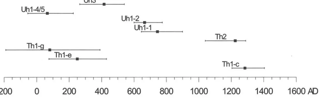
The C14 dates show that both sites underwent a first sliding event at ~100 AD (Fig. 2).
Figure 2. Calibrated C14 ages in the Serézé and Croix Polinard landslides with 95% confidence
intervals.
Three periods of reactivation are also recorded at about 400, 700 and 1250 AD, corresponding to a limited downward displacement of the toe of the Croix Polinard landslide and to the accumulation of secondary slumped material. Moreover, one should note that several of the landslides are currently active (namely with significant movements occurring in the Manaihan landslide during heavy rainfall periods in the last two years).
Note also that the first event that we record corresponds to the soil buried by the distal part of the toe: therefore, in order to associate it with the time of initiation of the slides, we must assume a catastrophic character for the first motion in both sites.
4. Discussion
When we consider potential triggering mechanisms for the Battice landslides, two main facts have to be taken into account. First, they all occurred within the same landslide-prone material composed of the Vaals smectites resting on the easily liquefiable Aachen sands. Secondly, despite the great extension of these formations in similar slope conditions in the eastern part of the Pays de Herve, landsliding was restricted to the Battice area, centred on the northern end of the Hockai fault zone.
Considering the first fact, we want to emphasize that the rapid facies or thickness variations of the involved formations could explain the particular location of the landslides. Indeed, if the liquefaction of the Aachen sands is the driving factor for a landslide to start, their thickness certainly is a critical parameter, this all the more as the Vaals formation concomitantly becomes coarser eastward.
On the other hand, in case the slide occurrences would be primarily material-dependent, the relationship to rainfall amount would be determining for the temporal pattern of landsliding. For instance, the present-day displacements recorded at Manaihan are unequivocally linked to periods of intense (September 1998) and especially prolonged (winter 1998–1999) rainfall. In NW Europe, several such more humid periods are identified in the 2500–2000 BR 1000– 1300 AD and 1550–1850 AD (little Ice Age) time intervals (Brunsden & Ibsen, 1994; Delmonaco et al., 1999).
The reactivation event of ~1250 AD at Sérezé could namely be related to one of these humid phases.
However, the first recorded event (~100 AD), possibly initiating the landslides in the Battice area, does not fall within these periods.
Combined to the spatial distribution of the landslides, this inclines us to consider a seismic triggering as another possible cause of landsliding, for which the following arguments maybe proposed:
1. occurrence of the landslides in close vicinity to the Hockai fault zone and absence in similarly favourable sites more distant from the fault (although facies variations may also partly explain this distribution).
2. synchronism of first recorded event in both dated sites.
3. sliding possibly linked to the liquefaction of the underlying Aachen sands. Dynamic liquefaction due to seismic shaking admittedly is the cause of many earthquake-triggered landslides (Seed, 1968).
While it is evidenced by the geophysics that the slip surfaces go down to the sands, the CPT and the static and dynamic slope stability analyses currently in progress should precise the exact role of this layer in the sliding process.
4. occurrence of the landslides on relatively gentle slopes with scarp development in the upper part of the slope.
Moreover, though needing more detailed investigation, the scarplet observed at Sérezé could be a further hint of a possible prehistoric earthquake.
On the contrary, one should note that the C14 dates revealed no sliding activity in relation with
the Verviers earthquake of 1692 (minimum estimated MSK intensity = VIII). In conclusion, even if a seismic triggering may appear possible, no definite origin can as yet be assigned to the Battice landslides. However, future paleoseismological studies of the Hockai fault zone should bear in mind the ~100 AD date.
References
BRUNSDEN D. & IBSEN M.L., 1994 – The temporal causes of landslides on the south coast of Great Britain. In European Community Programme EPOCH, Contract 90 0025, Temporal occurrence and forecasting of landslides in the European Community. Final report, Part 2, Case studies of the temporal occurrence of landslides in the European Community: 339–423.
DELMONACO G., MARGOTTINI C. & SERAFINI S., 1999 – Climate Change Impact on Frequency and Distribution of Natural Extreme Events: an Overview. In Floods and landslides: integrated Risk Assessment, R. Casale & C. Margottini Eds, Springer Verlag: 45–66.
SEED, H., 1968 – Landslides during earthquakes due to soil liquefaction. J. Soil Mech. Found. Div., Am. Soc. Civ. Eng., 94: 1055–1122.