POSTGLACIAL PALEOCEANOGRAPHY OF CENTRAL BAFFIN BAY
FROM PALYNOLOGICAL TRACERS
THE SIS
PRESENTED
IN PARTIAL REQUIREMENT
OF THE MASTERS IN EARTH SCIENCES
OF
SARAH STEINHAUER
.
.
.
UNIVERSITÉ DU QUÉBEC À MONTRÉAL Service des bibliothèques ·
Avertissement
La
diffusion de ce mémoire se fait dans le' respect des droits de son auteur, qui a signé le formulaire Autorisation de reproduire. et de diffuser un travail de recherche de_ cycles supérieurs (SDU-522 - Rév.01-2006). Cette autorisation stipule que «conformémentà
!_'article 11 du Règlement no 8 des études de cycles supérieurs, {l'auteur] concèdeà
l'Université du Québecà
Montréal une licence non exclusive d'utilisation et de . publication oe la totalité ou d'une partie importante de [son] travail d~ recherche pour 'des fins pédagogiques et non commerciales. Plus précisément, [l'auteur] autorise l'Université du Québec à Montréal à reproduire, diffuser, prêter, distribuer ou vendre des .· copies de. [son] travail de rechercheà
des fins non commerciales sur quelque support que ce soit, y compris l'Internet. Cette licence et cette autorisation n'entraînent pas une renonciation de (la] part [de l'auteur] à [ses] droits moraux nià
[ses] droits de propriété intellectuelle. Sauf entente contraire, [l'auteur] conserve la liberté de diffuser et de commercialiser ou non ce travail dont [il] possède un exemplaire.»UNIVERSITÉ DU QUÉBEC À MONTRÉAL
PALÉOCÉANOGRAPHIE POSTGLACIAIRE DU CENTRE DE LA BAIE DE
BAFFIN À PARTIR DE TRACEURS PALYNOLOGIQUES
MÉMOIRE
PRÉSENTÉ
COMME EXIGENCE PARTIELLE
DE LA MAÎTRISE EN SCIENCES DE LA TERRE
PAR
SARAH STEINHAUER
---
-AVANT-PROPOS
Ce mémoire de maîtrise est présenté sous la forme d'un article scientifique qui sera soumis à la revue Marine Micropaleontology. Par conséquent, la mise en forme ainsi que l'utilisation de la langue anglaise respectent les exigences de Marine Micropaleontology et non celles de l'Université du Québec à Montréal.
merci également à tout le personnel du GEOTOP et surtout à l'équipe du laboratoire de micropaléontologie pour leur aide ainsi qu'à mon co-directeur M. Claude Hillaire-Marcel. Un énorme merci à Lisa, Carolyne, Nouba et Sophie pour leur soutien sans faille. Et enfin, un
merci particulier à mes parents et ma soeur pour leurs encouragements et soutien à distance,
TABLE DES MATIÈRES
AVANT-PROPOS ... .ii
REMERCIEMENTS ... ~ ... iii
LISTE DES FIGURES ...
v
LISTE DES TABLEAUX ... vii
RÉSUMÉ ... , ... viii
INTRODUCTION GÉNÉRALE ... : ... l CHAPITRE 1 POSTGLACIAL PALEOCEANOGRAPHY OF CENTRAL BAFFIN BAY: PALYNOLOGICAL EVIDENCE ... 3
Abstract. ... 4
1. Introduction ... 5
2. Oceanic settings ... 6
3. Material and methods ... 7
3.1. Onboard measurements and core sampling ... 7
3 .2. Chronology ... 7
3.3. Geochemical analyses ... ~ ... 8
3.4. Microfaunal and palynological preparations and analyses ... 8
4. Results and discussion ... 9
4.1. Chronology and stratigraphy ... 9
4.2. Palynological content. ... Il 4.3. Reconstructions of sea-surface conditions ... 12
5. Discussion ... l3 6. Conclusion ... 14
7. AknowJedgements ... 14
APPENDICE A
TABLEAUX DE COMPTAGES ET CONCENTRATIONS DES PALYNOMORPHES
T
E
RRESTRES
E
T MARINS DE LA CAROTTE HU2008-0
2
9-014BC .
.
.
.
.
.
....
.
.
...
..
.
. 31
APPENDICEB
TABLEAUX DE COMPTAGES ET CONCENTRATIONS DES PALYNOMORP
HE
S
TERRESTRES ET MARINS DE LA CAROTTE HU2008-029-016TWC ...
..
...
.
... 33
--- --- - -- - -
-LISTE DES FIGURES
Figure Page
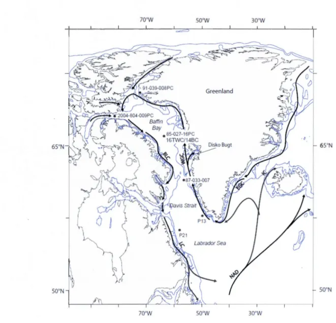
1.1. Location of cores HU2008-029-014BC (14BC) and HU2008-029-016TWC (16TWC)
(70.46°N, 64.66°W, water depth: 2060 rn and 2063 rn) and trajectories of main ocean surface
currents. Arrows illustrate the path of main currents. The location of cores referred in the text
is also illustrated. Isobaths correspond to 200 and 500 m. WGC: West Greenland Current,
EGC: East Greenland Current, BLC: Baffin Land Current, LC: Labrador Current, IC: Iceland Current, NAD: North Atlantic Drift ... .20
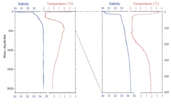
1.2. Temperature and salinity profiles at core site location (70.46°N, 64.66°W, water depth:
2060 rn). The CTD (Conductivity, Temperature, Depth) cast was made in late August during
expedition HU2008-029 (Campbell et al., 2008). The left diagram shows the profiles
throughout the entire water column and the right diagram is a blow up of the upper 600
meters ... 21
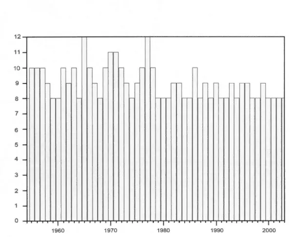
1.3. Sea-ice caver extent in months/year (>50%) at the coring site from 1953 to 2003. The
data were provided by the National Snow and lee Data Center
(NSIDC) ... 22
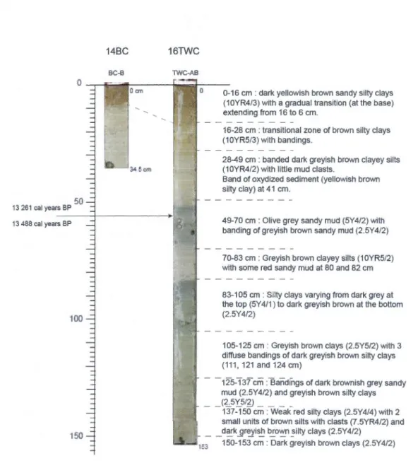
1.4. Photographs and summarised sediment core description of cores 14BC and 16TWC
taken immediately after the opening of the cores on board. See Table 1 for information on 14C
ages. The analysed section corresponds to the upper 64 cm. The code in parenthesis refers to colors from the Munsell chart ... 23
1.5. Lead-210 (in dpm/g) as a function of depth in cores 14BC and 16TWC. The !ines
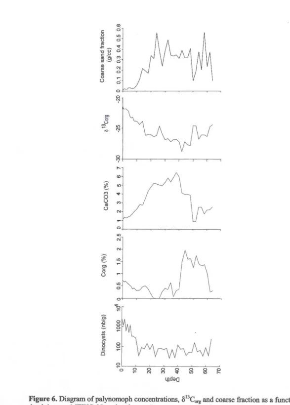
correspond to the logarithmic equation that could have been used to evaluate sedimentation
rates ... 24
1.6. Diagram of dinocysts concentrations, Corg, CaC03, ù
13
Corg and coarse fraction as a function of depth in core 16TWC. Note that the results are expressed with a logarithmic
scale ... 25
1.7. Diagram of dinocyst taxa percentages and dinoflagellate cyst assemblage zones as a
function of depth in core 16TWC ... : ... , ... 26
1.8. Maps of the surface distribution of the dinocyst taxa L pallidum (IPAL), O.
centrocarpum (OCEN), L minutum (IMIN).and S. elongatus (SEL0) ... : ... 27
1.9. Reconstructions of sea-surface temperature, salinity and sea-ice cover from dinocyst assemblages as a function of depth, based on the Modern Analogue Technique (MAT). The . modern values are represented by an arrow and their standard deviations by the grey areas ... 28
1.1. Radiocarbon ages from core 16TWC. The software Calib 6 for marine samples was used for calibration (Stuiver et al., 2005). No additional age correction for regional air-sea difference (delta R) was made ... 29
RÉSUMÉ.
Deux carottes sédimentaires de la partie centrale de la baie de Baffin (HU2008029-14B et -16TWC; 70.46°N 64.66°W; ~ 2060 rn) ont été échantillonnées afm de reconstituer les conditions hydroclimatiques holocènes à partir de l'analyse des assemblages de dinokystes. Des mesures 14C sur des carbonates biogéniques et des analyses de 210Pb sur le sédiment révèlent de très faibles vitesses de sédimentation, inférieures à 4,5 cm/ka. Un changement dans les assemblages de dinokystes est enregistré à 16 cm dans la carotte 16TWC, ce qui correspondrait à la fin de l'Holocène moyen, i.e. vers 4000 ans BP, si on postule des vitesses de sédimentation uniformes au cours de l'Holocène. La transition est marquée par une diminution de pourcentage du taxon polaire Impagidinium pallidum et par l'augmentation des proportions du taxon ubiquiste Operculodinium centrocarpum. Elle correspondrait à un réchauffement des eaux de surface que l'on associe à une pénétration plus importante des eaux nord-atlantiques via le courant ouest groenlandais. Les reconstitutions quantitatives des conditions de surface avec la technique des meilleurs analogues indiquent des conditions optimales, plus chaudes que l'actuel avec un couvert de glace moins étendu pendant la plus grande partie de l'Holocène supérieur. De tels résultats sont compatibles avec l'hypothèse d'une opposition des changements océanographiques dans le nord-ouest de l'Atlantique Nord par rapport à ceux du secteur nord-est. Les données suggèrent également des changements récents dans la baie de Baffin qui semble être extrêmement sensible vis-à-vis des variations hydroclimatiques liées aux courants de la Terre de Baffin et ouest groenlandais.
INTRODUCTION GÉNÉRALE
L'objectif des travaux de recherche entrepris dans le cadre de ma maîtrise était
d'améliorer la résolution des enregistrements des variations hydroclimatiq~es au cours de
l'Holocène par rapport aux études antérieures menées dans cette région. Pour ce faire, ont été
étudiés les sédiments de carottes prélevées lors de la mission du NGCC-Hudson en 2008
(Campbell et aL, 2008). Il s'agit des carottes-boîtes HU2008-029-014BC (14BC dans le texte;
70.46°N 64.66°W, profondeur d'eau: 2060 rn) et par gravité HU2008-029-016TWC (16TWC
dans le texte ; 70.46°N 64.66°W, profondeur d'eau : 2063 rn).
Située entre le Groenland et les Territoires du Nord canadien, la baie de Baffm est
une zone de convergence entre les masses d'eau issues de l'Arctique et de l'Atlantique (Fig.l ).
Il est donc important de retracer les variations hydrographiques de la baie de Baffin car cela
donne des informations sur l'historique des échanges entre ces deux océans. Des études ont
été menées sur la paléocéanographie de cette région dans les années 1970 et 1980,
notamment dans le cadre de la thèse de Aksu (1981) et suite à une expédition de l'Ocean
Drilling Program (ODP; Arthur et aL, 1985; Hillaire-Marcel et aL, 1989). Toutefois, ces
études n'ont pas livré de résultats probants en ce qui concerne les variations
paléocéanographiques à l'Holocène. D'une part, le sous-échantillonnage des carottes étudiées
a été fait selon un intervalle très large (tous les 10 à 20 cm dans la carotte HU85-027-0l6PC
située à proximité du site d'étude; Figure 1) ce qui se traduit par une faible résolution
chronologique des séries holocènes. D'autre part, les assemblages microfossiles dans cette
partie de la baie de Baffm sont pauvres, notamment en raison d'une dissolution du carbonate
de calcium et de la silice biogéniques (e g., Aksu, 1983). Par conséquent, l'amélioration des
techniques d'analyse depuis les années 1980, et surtout une maille d'échantillonnage plus
serrée, permettent d'espérer de meilleurs résultats.
Concrètement, la baie de Baffin est caractérisée par la rencontre des eaux froides et
peu salées de l'Arctique entrant par le Nord (détroits de Smith, Jones et Lancaster) et longeant
l'est de l'Ile de Baffin avec des eaux plus chaudes et salées provenant de l'Atlantique Nord.
Celles-ci sont véhiculées du Sud vers le Nord de la baie par le courant ouest groenlandais. Ces deux masses d'eau forment une gyre cyclonique. La baie de Baffin est formée de trois
masses d'eau distinctes sous une mince couche de surface d'environ 20 mètres qui enregistre d'importantes variations saisonnières. La couche supérieure s'étend de 20 à environ 200 mètres de profondeur, est très froide (-l,7°C) et serait originaire de l'Arctique. La couche intermédiaire est formée d'eau provenant de l'Atlantique et sa température atteint près de 2°C.
Enfm, la couche profonde se caractérise par une température décroissante avec la profondeur
qui peut atteindre un minimum de -0,4°C. Le couvert de glace de la baie de Baffin est à son maximum en mars et minimum en septembre. Au cours des 50 dernières années, le couvert de
glace annuel moyen (concentration >50%) a été de 9 mois/an (NSIDC).
Les reconstitutions hydrographiques de surface (température, salinité, couvert de glace, productivité) sont effectuées à partir des assemblages de kystes de dinoflagellés ou dinokystes. Les dinokystes qui sont constitués de matière organique réfractaire se fossilisent dans les sédiments marins. Ils forment des assemblages caractérisés par une diversité taxonomique élevée dans les milieux de hautes latitudes (de Vernal et al., 1994, 2001). Les reconstitutions ont été effectuées à partir de la technique des meilleurs analogues modernes (MAT) (de Vernal et al., 2005). On aurait souhaité utiliser d'autres traceurs que les dinokystes. Toutefois, dans le contexte interglaciaire des milieux profonds de la baie de Baffm, une dissolution totale de la silice et des carbonates biogéniques limite la portée de la plupart des autres approches micropaléontologiques.
CHAPITRE 1
POSTGLACIAL PALEOCEANOGRAPHY . OF CENTRAL BAFFIN BAY:
PALYNOLOGICAL EVIDEN.CE
Sarah STEINHAUER'*, Anne de VERNAL', Claude HILLAIRE-MARCEL'
Centre de recherche en géochimie isotopique et en géochronologie (GEOTOP),
Université du Québec à Montréal, Case postale 8888, Succursale Centre-Ville,
Montréal, Québec, Canada, H3C 3P8. Tel: +1-514-987-4080; Fax: +1-514-987-3635
*
Corresponding author: E-mail: [email protected]4
Abstract
Two sediment cores from central Baffin Bay (HU2008029-014BC and -Ol6TWC;
70.46°N 64.66°W, ~ 2060 rn) were analysed in order to reconstruct variations in hydroclimatic conditions during the Holocene based on dinocyst assemblages. Measurements of 14C in biogenic carbonate and 210Pb data from the top 12 cm of sediment suggest very low sedimentation rates during the Holocene (< 4.5 cm/ky). An important change in dinocyst assemblages is recorded at 16 cm in core 16TWC, which corresponds to about 4000 cal years BP assuming constant sedimentation rates throughout the Holocene. The change is marked by a decrease in the relative abundances of the polar taxa lmpagidinium pallidum relative to an
increase of the ubiquitous taxa Operculodinium centrocarpum. This suggests warming of
surface waters in response to enhanced contribution of the Atlantic waters flowing northward through the West Greenland Current. The quantitative reconstruction of sea-surface conditions from the modem analogue technique (MAT) indicates optimal conditions during
the late Holocene, with summer sea-surface temperatures higher than today. The overall
results are compatible with the hypothesis of opposite pattern of changes in the northwest vs.
northeast North Atlantic. These data suggest that Baffin Bay sea-surface conditions are extremely sensitive to hydroclimatic variations linked to the Baffin Land Current and the West Greenland Current.
1 Introduction
Baffin Bay is a large transitional basin that extends from the Arctic to the North Atlantic Ocean. It is also a discharge basin for ice, meltwater and sediment from the lnnuitian and Greenland ice sheets. Freshwater, meltwater, and sea-ice flowing from the Arctic through Baffin Bay and Davis Strait control sea-surface salinity and temperature in the Labrador Sea, thus playing a determinant role on water mass stratification and intennediate to deep water formation ( e.g., Rudels, 1986).
Severa! studies conducted in Baffin Bay have documented environmental changes that occurred during the Holocene. These studies include using proxies such as diatoms, benthic foraminifera and dinocysts (Levac et al., 2001; Hamel et al., 2002; Knudsen et al.,
2008; Seidenkrantz et al., 2008; de Vernal, 1986; de Verna\ and Hillaire-Marcel, 1987). However, most of these studies were performed in northernmost Baffin Bay or in the nearshore Disko Bugt area along the western Greenland coast, which are sites above the lysoclineand characterized by relatively high sedimentation rates. At these sites, the records mainly relate to local changes in environmental conditions. Hence, they cannat provide an integrated picture of the oceanographical conditions in Baffin Bay and do not permit assessments on freshwater export towards Labrador Sea. Central Baffin Bay would be a more suitable location for obtaining a regional picture of past oceanic changes in a major transitional basin. However calcium carbonate dissolution characterizes surface and Holocene sediments (Aksu, 1983; de Vernal et al., 1992), which makes it difficult to establish a chronostratigraphy. Moreover, the absence of calcareous and siliceous microfossils due to both carbonate and silica dissolution (Aksu, 1983) prevent the use of diatoms and foraminifers. By using dinocyst that are composed of highly resistant organic matter and usually very weil preserved in marine sediments including those of Baffin Bay (de Vernal et al., 1987; de Vernal and Mudie, 1989), we aim to reconstruct the sea-surface conditions (temperature, salinity, sea-ice caver and productivity) during the Holocene. Here we report on palynological assemblages analysed in core HU2008029-016TWC, which were collected during the expedition HU2008029 of the CCGS Hudson near the Ocean Drilling Program
(ODP) Site 645 (Arthur et al., 1985) and the site survey core-HU85-027-016PC (70.27°N
64.39°W; Hillaire-Marcel et al., 1989; de Vernal et al., 1989; de Vernal, 1986; de Vernal and Hillaire-Marcel, 1987).
6
2 Oceanic settings
The surface circulation in Baffin Bay forms a counter-clockwise gyre consisting of
two main components (Figure 1): (1) the West Greenland Current (WGC) which flows northwest along the west coast of Greenland to Nares Strait in summer but is diverted westward into Davis Strait in winter, (2) the Baffin Land Current (BLC) which is fed by water masses from the Arctic Ocean through Smith, Jones and Lancaster Sounds and flows ·
southward along the east coast of Baffin Island (Rudels, 1986).
Baffin Bay is composed of three different water masses below a thin (approx. 20 meters) and low salinity (<33) layer that records large seasonal variations from 5°C in summer to freezing in winter (Figure 2). The upper layer extends down to 200 meters and originates from the Arctic. It is cold with a temperature close to freezing point and salinity of approximately 33-33.7 (Zweng and Münchow, 2006). The intermediate layer is of North Atlantic origin. It records maximum temperature of 2°C at 500 meters. Below the intermediate layer is the deep intermediate layer which records decreasing temperatures down to -0.4°C in bottom waters, where the salinity reaches 34.44.
Modern summer sea-surface temperature and salinity at the coring site are 3.23 ±
l.32°C and 29.6 ± 0.49 respectively (World Ocean Atlas, 2001). An increase in primary productivity generally occurs from May to September and is estimated at 70 gC/year from
MODIS (http://daac.g fc.nasa.gov).
The low salinity in the surface water layer is due to the freshwater fluxes from the Canadian Arctic Archipelago. The flow is weaker in winter and stronger in summer (Dickson
et al., 2007). Prinsenberg and Hamilton (2004, 2005) have calculated a freshwater flux of 48 mSv (liquid) plus 1.3 mSv (solid) through Lancaster Sound. Münchow et al. (2006) have estimated the freshwater flux through Nares Strait to be 25 ± 12 mSv. The Greenland ice
sheet represents a large freshwater reservoir in the Northern Hemisphere. Its annual
freshwater flux is estimated at 18 mSv, which is divided between Baffm Bay and the
Green! and Sea. ln Davis Strait, at the outlet of Baffin Bay, mean annual values of 72 to 130
mSv have been reported (Dickson and al., 2007). These values take into account large
variations recorded since the 1980s. They may be underestimated in a perspective of climate
Sea ice extent reaches its maximum in Marchand minimum in September. ln Baffm Bay, the sea-ice extent from 1972 to 1995 is 1.13x10⁶ km2 (Tang et al., 2004). Between 1953 and 2003, the seasonal extent of sea-ice cover at our study site averaged 9 months/year with a standard deviation of 1.1 (Figure 3; data compiled from the National Snow and lee Data Center in Boulder).
3 Materia1 and methods
3.1 Onboard measurements and core sampling
The trigger weight core HU2008029-0l6TWC (hereafter 16TWC; 70.46°N 64.66°W, 2063 rn) and the companion Box core HU2008029-014BC (hereafter l4BC; 70.46°N 64.66°W, 2060 rn) were collected during the HU2008029 expedition of the CCGS Hudson.
The core 14BC was collected with a box-corer of 50 x 50 cm. Five push-cores were collected from the box using the vacuum backpressure technique to prevent compression (Campbell et al., 2008). The 34 cm long push-core selected for our study was subsampled by extrusion at 1 cm intervals. Here we report on 210Pb analyses performed on the upper 12 cm of core 14BC. Palynological and geochemical results are reported by Steinhauer (20 12).
The trigger weight core HU2008029-016TWC (hereafter 16TWC; 70.46°N 64.66°W, 2063 rn) was split onboard and described visually. A working half was sampled for paleomagnetism (u-channel). lt was subsampled every centimeter and we analysed the upper 64 cm of this 155 cm-long core (Figure 4).
3.2 Chrono/ogy
Analyses of 210Pb were made in the upper 12 cm of cores 14BC and J6TWC to determine the sedimentation rate at the coring site. Analyses of 137Cs were also conducted in the upper 5 cm to identify the 1967 peak (Ritchie and McHenry, 1990). All analyses were carried out at the GEOTOP research center.
8
and crushed in an agate mortar. The 210Pb activities were obtained by measuring the decay rate of its daughter isotope 210Po (t112=138.4 days; a=5.30 MeV) with an a-spectrometer and
by adding 209Po as a spike to determine the extraction and to count the efficiency. Chemical treatments with HCI, HN03, HF and H202 were done to extract and purify the polonium
before making electro-depositions on silver disks (Flynn, 1968).
As for the 137Cs, sediments were analyzed by gamma-spectrometry after preparation, which consisted of drying and crushing similarly to the 210Pb analyses.
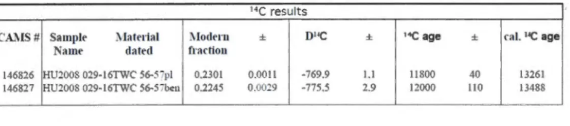
No calcareous microfossils was found in core l4BC and the uppermost occurrence of calcareous fauna in core 16TWC is at 52 cm. Foraminifer shells of both benthic and planktic taxa were sufficiently abundant at 56 cm to be hand-picked for radiocarbon dating. The conventional 14C ages were calibrated using the Calib 6 software (Stuiver et al., 2005), which includes a correction of 400 years for the air vs. marine reservoir. No additional correction for regional air-sea reservoir effect (delta R) was applied.
3. 3 Geochemical analyses
Samples have been dried out and crushed in an agate mortar before being analyzed with a Carlo Erba Elemental Analyser to determine total weight percent carbon and nitrogen contents.
The inorganic carbon content was measured with a coulometer on 20-40 mg of sediment. The organic carbon content was calculated by subtracting the inorganic carbon content from the total carbon content. Sorne tests which consisted of fumigating the sam pies
with HCI allowed us to verify the accuracy of the method. According to Hélie (2009),
coulometry is the most accurate method to determine inorganic carbon. The
o
13Corg has been measured using the Carlo Erba and reported vs. VPDB. Reproducibility tests indicate an accuracy of± 0.1 %o.3. 4 Microfaunal and palynological preparations and analyses
For each sample, about 5 cm3 were processed following the protocol described in de
clays and coarse particles. During sieving, one tablet of Lycopodium spores was added in order to determine concentrations following the marker-grains method (Matthews, 1968). After the first sieving, the fraction between 106 !lill and 10 J..Lm was treated successively with HCl (10%) and HF (49%) in order to eliminate carbonate and silica particles, respectively.
The residue was mounted with glycerine gel between a slide and cover slide for examination by optical microscopy with transmitted light at 400X magnification. Ali palynomorphs were counted (Steinhauer, 2012). They include dinocysts, pollen grains,
spores, reworked palynomorphs and organic linings from benthic foraminifera. The
nomenclature of dinocysts was conformed to Roch on et al. (1999) and Head et al. (200 1 ).
Here we are only reporting the dinocysts. The occurence of other palynomorphs is very low. The fraction greater than 106 !lill was dried and examined with a binocular microscope in order to handpick foraminifera for radiocarbon dating. This fraction was then
weighed since it pro vides an indication of the coarse sand content.
The past sea-surface conditions were reconstructed from dinocyst assemblages by using the modem analogue technique (MAT), which estimates past environmental conditions from the modem ones at sites containing similar modern assemblages (Guiot, 1990; Guiot
and de Vernal 2007). We used the software R to perform MAT and an update of the Northern Hemisphere reference database of dinocyst assemblages (de Vernal et al., 2005; Radi and de Vernal, 2008; Bonnet et al, 2010) that comprises 1408 surface sediment sample sites and
includes 64 from Baffin Bay.
4 Results
4.1 Chrono/ogy and stratigraphy
Previous work from central Baffin Bay at ODP Site 645 and in nearby cores
suggested mean sedimentation rate of about 8-13 cm/ky during the Pleistocene (e.g., de
Vernal et al., 1987; de Vernal and Mudie, 1989; Hillaire-Marcel et al., 1989). The two
radiocarbon dates obtained from benthic and planktic foraminifera hand-picked at 56-57 cm
in core 16TWC yielded ages of respectively 13 488 cal. years BP and 13 261 cal. years BP
(Table 1). These ages indicate an average sedimentation rate of about 5 cm/ky during the
10
sedimentation rates of 4 to 8 cm/ky (Simon et al., 201 0). Thus, th ose data suggest lower
sediment accumulation rate during the present interglacial than during glacial stages. This is compatible with reduced detrital input from surrounding lands after the glacial retreat along the northeastern coasts of Canada (e.g., Dyke, 2002) and northwest Greenland (e.g., Long, 1994).
The 210Pb analyses in cores 14BC and 16TWC provide complementary data about
sedimentation rates, but the results show profiles that cannot be interpreted easily (see Figure
5). None of the profiles show an upper mixing zone. The asymptotic trend of 210Pb activities downcore suggests supported 210Pb of about 1 dpm/g, with excesses starting to increase above 7 cm in box core 14BC and close to 12 cm in gravity core 16TWC. Maximum values of 10.68 dpm/g and 7.32 dpm/g are obtained within the surface of cores 14BC and 16TWC, respectively. The 210Pb profiles could be used to calculate sedimentation rates of 14 cm/ky
and 12 cm/ky respectively. However, the profiles can also be related to biological mixing and
diffusion in the sediment. This is 1ike1y the case in view of the 14C ages and paleomagnetism data. Moreover, the samples do not contain detectable 137Cs, which also confirms low
sedimentation rates and biological mixing. Whereas the 210Pb data are not conclusive in terms of sedimentation rate, they demonstrate compaction in the box core 14BC as compared to the
. gravity core 16TWC. Compaction may have occurred while sampling the push core in spite
of the use of a vacuum pump. More likely, it occurred when sampling the push core by extrusion.
From available data, jt seems clear that sedimentation rates are lower during postglacial than glacial stages or transitional periods. However one cannot assume constant sedimentation rates during the entire postglacial period. More abondant ice rafted debris (IRD) in the lower part of the core, below 10 cm (Figure 6), suggests higher detrital input and th us higher sedimentation rate during the earl y part of the postglacial. This wou Id imply a decrease in sedimentation rate towards the top of the core.
The geochemical profiles (CaC03, Corg• ô 13
C0rg) of the sediment records exhibit large
amplitude variations (Figure 6). The Corg ranges from 0 to 1.95% ( 44-45 cm) with an average of 0.65%. The CaC03 content is variable reaching up to 6.44%. Considering the rarity of
calcium carbonate microfossils in the section above 52 cm in core 16TWC, the CaC03 content Iikely relate to detrital inputs (Aksu, 1983). Abondant detrital CaC03 below 20 cm is
thus compatible with abundant coarse sand debris (Figure 6). The ô13Corg averages -25.23%o.
However, the ô13Corg in the upper 10 cm of the core increases to -21.67%o (Figure 6). Such
values are similar to those reported by Hillaire-Marcel et al. (1989) from nearby ODP site
645. The ô13Corg suggest variations in the input of terrestrial vs. marine organic matter with a
predominance of terrestrial organic matter in the lower part of the record. The higher ô 13Corg
values in the upper part of the core suggest a slight increase in marine fluxes relative to terrestrial inputs.
4.2 Palynological content
The palynological content of core 16TWC is characterized by low concentrations of
pollen grains, spores, reworked palynomorphs, organic linings of forarninifera (<100/g) and
by moderately high concentrations of dinocysts (up to 1200 cysts/g). Dinocyst concentrations
are higher in the upper 10 cm of the core (Figure 6) which indicates higher productivity.
These results are consistent with the ô13Corg· The . low concentration of terrestrial
palynomorphs is due both to low pollen production in the Arctic tundra of adjacent lands and
distance from land (cf. Rochon and de Vernal, 1994). The concentration of marine
palynomorphs notably dinocysts is rdatively low, yielding fluxes lower than 5 cysts.cm.2.y"1•
This suggests low productivity in central Baffm Bay, which is consistent with the low
chlorophyll content measured in the upper water column (Herman, 1983).
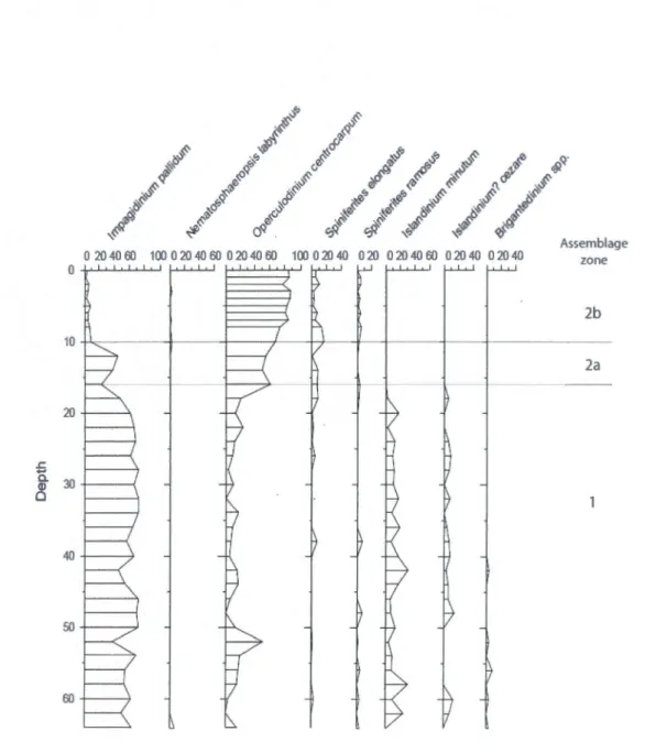
The dinocyst assemblages are dominated by Impagidinium pallidum from the base of
the core to 18 cm and by Operculodinium centrocarpum above 18 cm (Figure 7). Thus, two
main assemblage zones can be defined:
(1) The lower zone (base of the core to 18 cm), defined by the dominance of Impagidinium
pallidum, also contains Islandinium minutum and Islandinium? cezare. This assemblage corresponds to cold polar conditions (e.g. de Vernal et al., 2001). Impagidinium pallidum is
an oligotrophic taxon occurring in the open ocean settings of polar and subpolar seas
(Matthiessen et al., 2005), High percentages of this taxon characterize the surface sediment of
the Greenland Sea area where summer sea-surface temperature and salinity are 6°C and 34 respectively (de Vernal et al., 2005; Radi and de Vernal, 2008; Bonnet et al, 2010) (Figure 8). (2) The upper zone (18 cm to surface) is characterized by the dominance of Operculodinium centrocarpum, the disappearance of Islandinium spp. and the presence of Nematosphaeropsis
12
labyrinthus, Spiniferites elongatus and S. ramosus. This assemblage is exclusively composed of Gonyaulacales, which suggests subpolar conditions and may reflect the influence of Atlantic waters. A transition zone between 18 and 10 cm is marked by an assemblage
characterized by both I pallidum and O. centrocarpum. This led to distinguish subzones 2a
(18-10 cm) and 2b (10-0 cm).
In the upper part of the core, the absence of Protoperidiniales such as Islandinium
might reflect poor preservation due to oxidation processes (e.g., Zonneveld 1997). However,
there is no indication of alteration or poor preservation of other dinocysts. Moreover, when
we consider Gonyaulacale taxa exclusively because they are Jess susceptible to degradation
by oxidation (Zonneveld, 1997), the assemblages remain very different. In the Disko Bugt
area, P dalei is dominant (Andresen et al., 2010; Ribeiro et al., 2012) whereas it is rarely recorded in the central Baffin Bay. Similarly, in the northem Baffin Bay, Protoperidiniales
dominate but I pallidum occurs in much lesser percen~ages than P dalei. Therefore, even
when taking into account possible biases due to oxidation, assemblages from central Baffin
Bay significantly differ from those of the western Greenland margin off Disko Bugt (cf.
Andresen et al., 2010; Ribeiro et al., 2012) and northem Baffin Bay (cf. Levac et al., 2001;
Ledu et al., 2008).
Dinocyst assemblages from central Baffin Bay thus appear specifie to the area and correlations with the postglacial dinocyst stratigraphy ofDisko Bugt and northem Baffm Bay
carmot be made easily.
4. 3 Reconstructions of sea-surface conditions
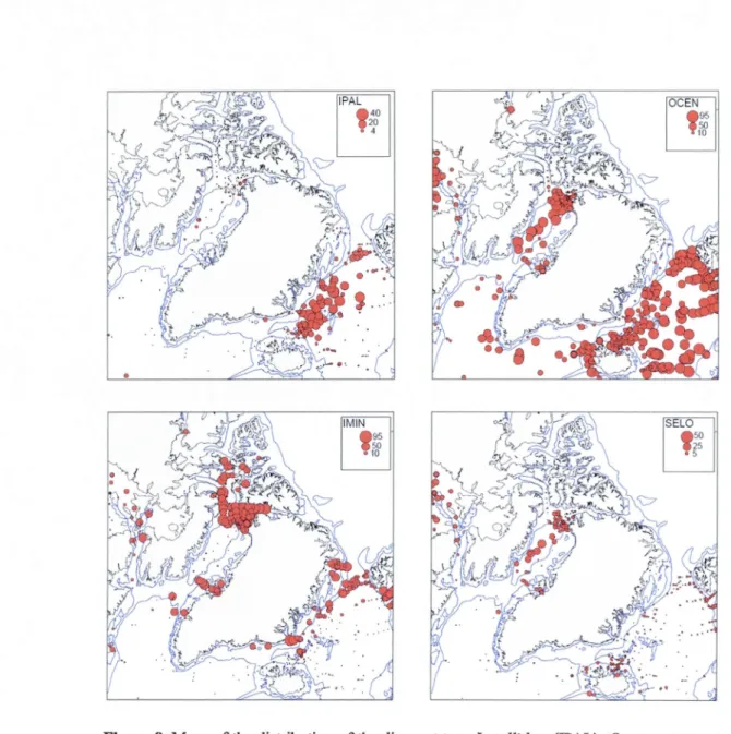
In arder to reconstruct sea-surface conditions, we used the modem analogue
technique (MAT) applied to dinocyst assemblages. In most of the samples, close analogues
are identified. In the lower part of the record, which is characterized by high percentages of I
pallidum, the best analogues are mostly from offshore sites of the Greenland Sea, where cold water and Iow productivity are presently recorded. In the upper part of the record, the analogues are mostly found in the Baffin Bay area.
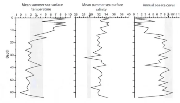
Results from core 16TWC show làrge amplitude variations in surnmer sea-surface temperature (SST) and salinity (SSS) as weil as seasonal duration of the sea-ice cover (Figure 9). In the lower part of the sequence (below 18 cm), results indicate cold conditions and sea
-ice cover up to 9 months/year, which is close to modem values. From 18 to 8 cm, data suggest a trend towards increased temperatures accompanied by a decrease of sea-ice cover towards values close to sea-ice free conditions. The upper 8 cm present maximum SSTs (4
-90C) and minimum sea-ice cover (<6 months/year). Oscillations are also recorded. However, due to poor time resolution. of analyses, the data do not permit to identify a structure in the changes.
The coarse sand content of the core is high (> 0.10 g/cm3) below 10 cm. This
indicates abundant ice-rafted input which is compatible with dense sea-ice cover. Reconstructions at the top of the core yield conditions different than the modem. This can be due to the fact that the surface sediment sample integrates severa! hundred years, whereas the modem represent the last few decades only. ln any case, overall the record indicates that optimal conditions in surface water established only during the second half of the Holocene ..
They also suggest that the modem conditions obsenied at the scale of the last decades are not representative ofthose recorded during the last millennia.
5 Disçussion
The Jack of precise chronology and the overall low sedimentation rates makes it di:fficult to interpret the record of core 16TWC in a regional to hemispheric perspective. Assuming constant sedimentation rates over the studied sequence, the main transition from cold to cool conditions that is recorded at 18 cm occurred after approximately 4000 years BP. However, this transition could have been earlier in the hypothesis of decreasing sedimentation rate towards the top of the core. Des pite uncertainties with the exact age of the transition, the results suggest a late establishment of optimal interglacial conditions in central Baffin Bay. The data also point to dinocyst assemblages that were very different from those of the Labrador Sea during the earl y and rnid-Holocene. lndeed, in the Holocene cores of the Labrador Sea, none of the dinocyst assemblages are dominated by I pallidum, which never represents more than 5% ofthe assemblages. Holocene dinocyst assemblages of the Labrador Sea are rather dominated by P. dalei and N labyrinthus (cores P13 and P21 in Figure 1; de Vernal et al., 2001; Solignac, 2004). The differences between Labrador Sea and Baffin Bay assemblages during the early rnid-Holocene suggest isolation of the Ba:ffm Bay basin and
14
therefore a weak northward penetration of Atlantic water masses, at !east in surface waters.
The dinocyst assemblages, geochemical and sedimentological content of core 16TWC also
suggest very harsh conditions in surface waters with low temperatures, dense sea-ice cover,
ice calving and icebergs and low productivity during the early Holocene and probably until
the late Holocene. High calving activity and melwater supply in northem Baffin Bay along
the Canadian and Greenland ice sheet margins during the frrst part of the Holocene is
compatible with the ice core record of the Agassiz ice cap that shows important melt layers
until about 4000 years BP, (Fisher et al., 1995). lee calving and meltwater discharges could
weil ex plain particularly strong stratification of surface water masses and dense sea-ice co ver
in the Baffm Bay during an interval also marked by high surnmer insolation in the Northem
Hemisphere (Berger, 1978). The regional response of Baffin Bay we reconstruct here is
compatible with sorne terrestrial records of northeastem Canada where a delayed
establishment of the Holocene thermal optimum is observed (e.g. Kaufman et al., 2004;
CAPE project members, 2001).
6 Conclusion
The record of core 16TWC provides unique data to document climate and ocean
changes in central Baffm Bay during the Holocene. Despite uncertainties with respect to the
chrono! ogy, the results show an important transition during the mid-Holocene, with a change
from assemblages dominated by I pallidum to assemblages dominated by O. centrocarpum.
During the early part of the Holocene, the overall data point to the existence of harsh
conditions in baffin Bay and the composition of dinocyst assemblages suggest very limited
influence of the West Greenland Current and North Atlantic waters, at !east in the surface
water layer. This does not exclude the possibility of the penetration of subducting North
Atlantic water below a low density surface layer, Actually, the data also indicate terrigenous
and ice rafted inputs during the early Holocene, which seems to have been marked by intense
ice calving activity and strong meltwater discharges along the Greenland and Canadian ice
sheet margins in the Baffm Bay, possibly as a response to high summer insolation in the
Northem Hemisphere. Therefore, the delayed establishment of Holocene thermal optimum in Baffin Bay would be a regional response forced by the presence of ice on surrounding lands.
During the mid-Holocene and possibly as late as 4000 years BP, reduced melting rates along
. the ice margins would have favoured higher surface salinity, the inflow of Atlantic water at
the surface and the establishment of relatively warm conditions. The record from Baffin Bay
thus illustrates the critical role of freshwater budget in the basin and point to complex
regional response of epi continental environments to global forcing.
7 Aknowledgments
This study was conducted using the material collected during the expedition
HU2008-029 funded by the Canadian Foundation for Climate and Atmospheric Science
(CFCAS) through the Polar Climate Stability Network (PCSN), the Geological Survey of Canada and the Natural Science and Engineering Research Council (NSERC) of Canada.
This is a contribution to the project Past4Future.
8 References
Aksu, A. E., 1981. Late Quaternary stratigraphy, paleoenvironments and sedimentation
history of Baffin Bay and Davis Strait (Ph.D. Dissert.). Dalhousie University, Nova
Scotia.
Aksu, A.E., 1983. Holocene and Pleistocene dissolution cycles in deep-sea cores of Baffin
Bay and Davis Strait: Palaeoceanographic implications. Marine Geology 53( 4), 331-348.
Andresen, C. S., McCarthy, O. J., Dylmer, C. V., Seidenkrantz, M.-S., Kuijpers, A. and Lloyd, J. M., 20 l O. Interaction between subsurface ocean waters and calving of the Jakobshavn lsbrae during the late Holocene. The Holocene 21 (2), 211-224.
16
Labrador Sea-Baffin Bay. Ocean Drilling Program.
Berger, A. L., 1978. Long-terrn variations of daily insolation and quatemary climatic
changes. Journal of Atmospheric Sciences 35(12), 2362-2367.
Bonnet, S., de Vernal, A., Hillaire-Marcel, C., Radi, T. and Husum, K., 2010. Variability of
sea-surface temperature and sea-ice cover in the Fram Strait over the last two
millennia. Marine Micropaleontology 74(3-4), 59-74.
Campbell, D. C., de Vernal, A. and shipboard scientific participants, 2008. CCGS Hudson
Expedition 2008029: Marine geology and paleoceanography of Baffin Bay and
adjacent areas, Nain, NL to Halifax, NS, August 28- September 23, 2008. Geological Survey of Canada, open file 5989.
CAPE project members, 2001. Holocene paleoclirnate data from the Arctic: testing models of global climate change. Quaternary Science Reviews 20, 1275-1287.
de Vernal, A. and Marret, F., 2007. Organic-walled dinotlagellate cysts: tracers of sea-surface
conditions. In: Hillaire-Marcel, C. and de Vernal, A. (Eds), Proxies in Late Cenozoic
paleoceanography. Developments in Marine Geology, Elsevier, pp. 735-764.
de Vernal, A., Eynaud, F., Henry, M., Hillaire-Marcel, C., Londeix, L., Mangin, S.,
Matthiessen, J., Marret, F., Radi, T., Rochon, A., Solignac, S. and Turon, J.-L., 2005. Reconstruction of sea-surface conditions at middle to high latitudes of the Northern
Hemisphere during the Last Glacial Maximum (LGM) based on dinoflagellate cyst
assemblages. Quaternary Science Reviews 24(7-9), 897-924.
de Vernal, A., Henry, M., Matthiessen, J., Mudie, P. J., Rochon, A., Boessenkool, K. P., Eynaud, F., Gresfjeld, K., Guiot, J., Hamel, D., Hartland, R., Head, M. J., Kunz-Pirrung, M., Levac, E., Loucheur, V., Peyron, 0., Pospelova, V., Radi, T., Turon, J.-L. and Voronina, E., 2001. Dinoflagellate cyst assemblages as tracers of sea-surface conditions in the northern North Atlantic, Arctic and sub-Arctic seas: the new 'n=677' database and its application for quantitative palaeoceanographic reconstruction.
Journal ofQuaternary Science 16(7), 681-698.
de Vernal, A., Henry, M. and Bilodeau, G., 1996. Technique de préparation et d'analyse en
Micropaléontologie, Les cahiers du GEOTOP 3, unpublished report, Université du
Québec à Montréal, Québec, Canada.
de Vernal, A., Turon, J.-L. and Matthiessen, J., 1994. Dinoflagellate cyst distribution in high latitude marine environments and quantitative reconstruction of sea-surface salinity,
temperature, and seasonality. Canadian Journal ofEarth Sciences 31(1), 48-62.
de Vernal, A., Bilodeau, G., Hillaire-Marcel, C. and Kassou, N., 1992. Quantitative
assessment of carbonate dissolution in marine sediments from foraminifer linings
de Vernal, A. and Mudie, P.J., 1989. Late Pliocene to Ho1ocene palynostratigraphy at ODP 645, Baffin Bay. Proceedings of the Ocean Drilling Program, Scientific Results Leg 105,387-399.
de Vernal, A., Hillaire-Marcel, C., Aksu, A. E. and Mudie, P.J., 1987. Palynostratigraphy and chronography of Baffin Bay deep sea cores: climatostratigraphic implications. Palaeogeography, Palaeoclimatology, Palaeoecology 61, 97-105.
de Vernal, A. and Hillaire-Marcel, C., 1987. Marginal paleoenvironments of the eastern Laurentide lce-Sheet and timing of the last ice maximum and retreat. Géographie physique et Quaternaire 41,265-277.
de Vernal, A., Larouche, A. and Richard, P.J.H., 1987. Evaluation of palynomorph concentrations: do the aliquot and the marker-grain methods yield comparable results? Pollen et spores 29(2-3), 291-303.
de Vernal, A., 1986. Analyses palynologiques et isotopiques de sédiments de la Mer du Labrador et de la Baie de Baffin. Éléments d'une climatostratigraphie du Pléistocène
supérieur dans l'est du Canada (Ph.D. Dissert.). Université de Montréal, Canada.
Dickson, R., Rudels, B., Dye, S., Karcher, M., Meincke, J. and Yashayaev, 1., 2007. Current estimates of freshwater flux through Arctic and subarctic seas. Progress in
Oceanography 73, 210-230.
Dunlap, E., DeTracey, B. M. and Tang, C. C. L., 2007. Short-wave radiation and sea ice in
Bafftn Bay. Atmosphere-Ocean 45 (4), 195-210.
Dyke, A. S., Andrews, J. T., Clark, P. U., Miller, G. H., Shaw, J. and Veillette, J. J., 2002. The Laurentide and Innuitian ice sheets during the Last Glacial Maximum. Quaternary Science Reviews 21 (1-3), 9-31.
Fisher, D. A., Koerner, R.M. and N. Reeh, N., 1995. Holocene climatic records from Agassiz
lee Cap, Ellesmere Island, NWT, Canada, Holocene, 5, 19-24.
F1ynri, W. W., 1968. The determination of low levels of polonium-210 in environmental
materials. Analytica ChiqlicaActa 43,221-227.
Guiot, J. and de Vernal, A., 2007. Transfer functions: methods for quantitative
paleoceanography based on microfossils. In: Hillaire-Marcel, C., de Vernal, A. (Eds.),
Proxies in Late Cenozoic paleoceanography. Developments in Marine Geology,
Elsevier, 523-563.
Guiot, J., 1990. Methodology of palaeoclimatic reconstruction from pollen in France.
- - - --- -- - - -- - --- ---- - --- - - - -- -- --- --- --- -- - · --- - -- - ---- --- -- - ---- - -
-18
Hamel, 0., de Vernal, A., Gosselin, M. and Hillaire-Marcel, C., 2002. Organic-walled microfossils and geochernical tracers: sedimentory indicators of productivity changes in the North Water and northern Baffin Bay during the last ~enturies. Deep-sea Research II 49, 5277-5295.
Head, M. J., Harland, R. and Matthiessen, J., 2001. Cold marine indicators of the Iate Quaternary: the new dinoflagellate cyst genus Islandinium and related morphotypes. Journal of Quaternary Science 16(7), 621-636.
Hélie, J. F., 2009. Elemental and stable isotopie approaches for studying the organic and inorganic carbon components in natural samples. IOP Conference Series: Earth and Environmental Science 5.
Herman, A. W., 1983. Vertical distribution patterns of copepods, chlorophyll, and production in northeastern Baffin Bay. Limnology and oceanography 28( 4), 709-719.
Hillaire-Marcel, C., de Vernal, A., Aksu, A. and Macko, S., 1989. High-resolution isotopie and micropaleontological studies of upper Pleistocene sediments at ODP site 645, Baffm Bay. Proceedings of the Ocean Drilling Program, Scientific Results 105, 599-616.
Kau:fman, D. S., Ager, T. A., Anderson, N. J., Andrews, J. T., Bartlein, P.J., Brubaker, L. B., Coasts, L. L., Cwynar, L. C., Duval!, M. L., Dyke, A. S., Edwards, M. E., Eisner, W. R., Gajewski, K., Geirsdottir, A., Hu, F. S., Jennings, A. E., Kaplan, M. R., Kerwin, M. W., Lozhkin, A. V., MacDonald, G. M., Miller, G. H., Mock, C. 1., Oswald, W. W., Otto-Bliesner, B. L., Porinchu, D. F., Rühland, K., Smol, J. P., Steig, E. J. and Wolfe, B. B., 2004. Holocene thermal maximum in the western Arctic (0-180°W). Quaternary Science Reviews 23(5-6), 529-560.
Knudsen, K. L., Stabell, B., Seidenkrantz, M.-S., Eiriksson, J. and Blake, W., Jr., 2008. Deglacial and Holocene conditions in northernmost Baffin Bay: sediments,
foraminifera, diatoms and stable isotopes. Boreas 37, 346-376.
Ledu, 0., . Roc hon, A., de Vernal, A. and St-Onge, G., 2008. Palynological evidence of
Holocene climate change in the eastern Arctic: a possible shift in the Arctic oscillation at the millennial time scale. Canadian Journal of Earth Sciences 45(11),
1363-1375.
Levac, E., de Vernal, A. and Blake, W., Jr., 2001. Sea-surface conditions in the northernmost
Baffin Bay during the Holocene: palynological evidence. Journal of Quaternary
Science 16(4), 353-363.
·Long, O. G and Drinkwater, M. R., 1994. Greenland ice-sheet surface properties observed by
the Seasat-A scatterometer at enhanced resolution. Journal ofGlaciology 40(135).
frequencies. New Phytologist 68(1), 161-166.
Münchow, A., Melling, H. and Falkner, K. K., 2006. An observational estimate of volume
and freshwater flux leaving the Arctic Ocean through Nares Strait. Journal of
Physical Oceanography Ill, C07016.
NOAA (National Oceanic and Atmospheric Administration), 201 O. http://www.noaa.gov/.
NSIDC (National Snow and lee Data .Center), 2003. Brightness temperature and ice
concentrations grids for the polar regions. User's guide. NSIDC Distributed Active
Archive Center, University of Colorado, Boulder.
Prinsenberg, S. J. and Hamilton, J., 2004: Oceanic fluxes through Lancaster Sound of the
Canadian Archipelago. ASOF Newsletter 2, 8-11.
Prinsenberg, S. J. and Hamilton, J., 2005. Monitoring the volume, freshwater and heat fluxes
passing through Lancaster Sound in the Canadian Archipelago. Atmosphere-Ocean 43, 1-22.
Radi, T. and de Vernal, A., 2008. Last glacial maximum (LGM) primary productivity in the
northern North Atlantic Ocean. Canadian Journal ofEarth Science 45, 1299-1316.
Ribeiro, S., Moros, M., Ellegaard, M. and Kuijpers, A., 2012. Climate variability in West
Greenland during the past 1500 years: evidence from a high-resolution marine
palynological record from Disko Bay. Boreas 43,68-83.
Ritchie, J. C. and McHenry, J. R., 1990. Application of radioactive fallout cesium-137 for
measuring soi! erosion and sediment accumulation rates and patterns: a review.
Journal of environmental quality 19(2), 0047-2425.
Rochon, A., de Vernal, A., Turon, J.-L., Matthiessen, J. and Head, M. J., 1999. Distribution of
recent dinoflagellate cysts in surface sediments from the North Atlantic Ocean and
adjacent seas in relation to sea-surface parameters. American Association of Stratigraphie Palynologists Foundation, Contribution series 35.
Rudels, B., 1986. The outflow of polar water through the Arctic Archipelago and the oceanographie conditions in Baffin Bay. Polar Research 4, 161-180.
Seidenkrantz, M.-S., Roncaglia, L., Fischel, A., Heilmann-Ciausen, C., Kuijpers, A. and
Moros, M., 2008. Variable North Atlantic clirnate seesaw patterns documented by a
tate Holocene marine record from Disko Bugt, West Greenland. Marine
Micropaleontology 68, 66-83.
Simon, Q., Hillaire-Marcel, C. and Saint-Onge, G, 2010. High-resolution
magnetostratigraphy from central Baffin Bay for the last climatic cycle: initial results.
20
Solignac, S., de Vernal, A. and Hillaire-Marcel, C., 2004. Holocene sea-surface conditions in the North Atlantic-contrasted trends and regimes in the western and eastern sectors (Labrador Sea vs. lee land Basin). Quaternary Science Reviews 23, 319-334.
Steinhauer, S., 2012. Paléocéanographie postglaciaire du centre de la Baie de Baffin à partir de traceurs palyno1ogiques. M. Sc. Thesis, Université du Québec à Montréal, Montréal, Canada.
Stuiver, M., Reimer, P. J. and Reimer, R. W., 2005. CALIB radiocarbon calibration HTML version 6.0.1 and marine correction database, http://calib.qub.ac.uk/calib/.
Tang, C. C. L., Ross, C. K., Yao, T., Petrie, B., DeTracey, B. M. and Dunlap, E., 2004. The circulation, water masses and sea-ice of Baffin Bay. Progress in Oceanography 63, 183-228.
Zonneve1d, K. A. F., 1997. Dinoflagellate cyst distribution in surface sediments from the Arabian Sea (northwestem Indian Ocean) in relation to temperature and salinity gradients in the upper water column. Deep Sea Research Part II: Topical Studies in Oceanography 44(6-7), 1411-1443.
Zweng, M. M. and Münchow, A., 2006. Warming and freshening ofBaffm Bay, 1916-2003. Journal ofGeophysical Research vol. 111, C07016.
SO"W 30"W
70"W SO"W 30"W
Figure 1. Location of cores HU2008-029-014BC (14BC) and HU2008-029-016TWC
(16TWC) (70.46°N, 64.66°W, water depth: 2060 rn and 2063 rn) and trajectories of main ocean surface currents. Arrows illustrate the path of main currents. The location of cores referred to in the text is also illustrated (P21: see de Vernal et al., 2001; P13: see Solignac et al., 2004). lsobaths correspond to 200 and 500 m. WGC: West Greenland Current, EGC: East Greenland Current, BLC: Baffm Land Current, LC: Labrador Current, IC: Iceland Current, NAD: North Atlantic Drift.
22
Salinity Temperature (0 C) Salinity Temperature (0 C) 30 31 32 33 -2 -1 0 1 2 3 4 30 31 32 33 -2 -1 0 1 2 3 4 0 t-===="""=~~ ~~~~~=!;...-"t - ---- ---- -_._ ... _._... L...C...-1...-..L...L....- ' t T - f. 0 500 1500 2000 30 31 32 33 34 35 0 1 2 3 4 ' ' ' ' ' ' ' ' ' ' 100 200 300 400 30 31 32 33 34 35 0 1 2 3 4Figure 2. Temperature and salinity profiles at core site location (70.46°N, 64.66°W, water
depth: 2060 rn). The CTD (Conductivity, Temperature, Depth) cast was made in late August
during expedition HU2008-029 (Campbell et al., 2008). The left diagram shows the profiles
throughout the entire water column and the right diagram is a blow up of the upper 600 meters.
12 11
-10 -9-
r -8 -7 -6 -5 -4-3 -2 -0 1 1 1 1 1 1960 1970 1980 1990 2000
Figure 3. Sea-ice cover extent in months/year (>50%) at the coring site from 1953 to 2003.
50 13 261 cal years BP 13 488 cal years BP 100 150 14BC BC-8 16TWC TWC-AB
0 0-16 cm: dark yellowish brown sandy silty clays
(10YR4/3) with a graduai transition (at the base)
extending from 16 to 6 cm.
16-28 cm : transitional zone of brown silly clays
(10YR5/3) with bandings.
24
28-49 cm : banded dark greyish brown clayey silts
(10YR4/2) with little mud clasts.
Band of oxydized sediment (yellowish brown
silly clay) at 41 cm.
49-70 cm: Olive grey sandy mud (5Y4/2) with
banding of greyish brown sandy mud (2.5Y4/2)
70-83 cm: Greyish brown clayey silts (10YR5/2) with some red sandy mud at 80 and 82 cm
83-105 cm : Silly clays varying from dark grey at
the top (5Y4/1) to dark greyish brown at the bottom
(2.5Y4/2)
105-125 cm : Greyish brown clays (2.5Y5/2) with 3
diffuse bandings of dark greyish brown silty clays
(111, 121 and 124 cm)
- -125-137 cm : 8andlngs of dark brownish grey sandy
mud (2.5Y4/2) and greyish brown silty clays
- _('?c_5Y._5!?J - - -
-137-150 cm: Weak red silty clays (2.5Y4/4) with 2
small units of brown silts with clasts (7.5YR4/2) and
_ _ d~k Jlr~i~ ~o~n _:;illy cl a ys (2.5Y 4/2) 150-153 cm: Dark greyish brown clays (2.5Y4/2)
Figure 4. Photographs and summarised sediment core description of cores 14BC and 16TWC taken immediately after the opening of the cores on board. See Table 1 for information on 14C
ages. The analysed section corresponds to the upper 64 cm. The code in parenthesis refers to
210-Lead in 14BC 210-Lead in 16TWC 0 2 4 6 8 10 12 0 2 4 6 8 10 12 o~---L----L---~~~----~--~ 2 4 4 -6 6 J 8 8 -10 10 -f(x)= -4.02 ln(x)+9.82 f(x)=-9.421n{x)+ 17.53 12 12
-Figure 5. Lead-210 (in dpm/g) as a function of depth in cores 14BC and 16TWC. The lines
<q c: 0 0
"'
·
n
0 ~ .... -~ 0 -o <J ~.a, ~ (/)~ 0 (!) ~ ro 0 u e> 0 u ~ ~ ~ ('") 0 u ro u ~ ~ Ol 0 u~
.s
(/) (ii >-() 0 c: i5 "! 0 "": 0 0 0 ~"'
~ 0 '? ,._ (!)"'
.... (") N 0"'
N N"'
"'
026
~
Figure 6. Diagram ofpalynomoph concentrations, S13Corg and coarse fraction as a function of
~~ &oiS
l
·
,l
.
if
~ ~~ ,~ 0 204060 100 0204060 0204060 100 02040 020 0204060 02040 02040 AssemblageFigure 7. Diagram of dinocyst taxa percentages and assemblage zones as a function of depth
28
lM IN
'
•10~
Figure 8. Maps of the distribution of the dinocyst taxa 1. pallidum (IPAL), O. centrocarpum
(OCEN), !. minutum (IMIN) and S. e/ongatus (SELO) in surface sediment samples (cf. data
Mean summer sea-surface Mean summer sea-surface An nuai sea-ice cover temperature salinity -1 o 1 2 ,1 4 s 6 1 8 9 10 26 28 ~o 32 34 36 38 40 o 1 2 3 4 s 6 7 8 SI 101112 0 ':'t' +-.1-....J..._..:.L..._J...J.~!::'-'-.L....I..._ ... ,, 1 10 20 ..c ë_ 30 ~ 40 50 60
Figure 9. Reconstruction of sea-surface temperature, salinity and sea-ice co ver from dinocyst assemblages as a function of depth, based on the Modern Analogue Technique (MAT). The
30
14C results
CA!\IS # Samplr :\Iatrrial Iodrrn ± D"C ± ••c age ± cal. "Cage
Na mt dattd fraction
146826 HU2008 029-l6TWC 56-57pl 0.2301 0.0011 -769.9 1.1 11800 40 13261 146827 HU2008 029-!6TWC" 56-57ben 0.2245 0.0029 -ïï5.5 2.9 12000 110 13~88
1) The quoted age is in radiocarbon years ttSing the Libby ha1f li fe of 5568 years and follo,\ing the com·entions ofSmi,·er and Po1ach (ibid.). 1) The mtc<I1ainty on CAMS# 146827 is 1arger due to the small size of tlte samp1e ( -1 OOfogC).
Table 1. Radiocarbon ages from core 16TWC. The software Calib 6 for marine samples was
used for calibration (Stuiver et al., 2005). No additional age correction for regional air-sea
CONCLUSION GÉNÉRALE
La Baie de Baffm est une zone géographique importante à étudier de part sa
localisation entre l'Océan Arctique et l'Océan Atlantique Nord. Par contre, peu d'enregistrements sont disponibles et ceux-ci ont une faible résolution qui ne permet pas une interprétation optimale. Grâce à cette étude et à des méthodes analytiques plus performantes, il a été possible de reconstituer des changements dans les conditions d'eau de surface de la Baie de Baffin.
Malgré une forte dissolution des carbonates et silice biogéniques, les assemblages de
dinokystes illustrent des changements importants dans les masses d'eau.
L'absence de chronologie précise et les t31-ux de sédimentation relativement faibles rendent l'interprétation de la carotte 16TWC difficile. Si l'on suppose des taux de sédimentation constants pour la séquence étudiée, la transition majeure entre des conditions froides et fraîches (18 cm) prendrait place vers 4000 ans BP si ce n'est plus tôt selon l'hypothèse d'un
ralentissement du taux de sédimentation dans la partie supérieure de la carotte. Cela
suggèrerait une mise en place tardive des conditions interglaciaires optimales au centre de la baie de Baffin. Jusqu'à environ 4000 ans BP ou plus tôt, les assemblages de dinokystes
dominés par l pallidum sont différents de ceux de la mer du Labrador ce qui impliquerait un
isolement du bassin et une faible pénétration des eaux de surface dans la baie de Baffin. Les
dinokystes et les données géochimiques et sédimentologiques de la carotte indiquent des
conditions très rudes avec des températures basses, un couvert de glace dense incluant la présence d'icebergs, et une faible productivité jusqu'à la fm de l'Holocène.
Après 4000 ans BP, la dominance de O. centrocarpum dans les assemblages de dinokystes indique une pénétration des eaux de l'Atlantique et la mise en place de conditions plus clémentes avec une productivité plus élevée.
APPENDICE A
TABLEAUX DE COMPTAGES ET CONCENTRATIONS DES PALYNOMORPHES
TERRESTRES ET MARINS DE LA CAROTTE HU2008-029-014BC
Profondeur {c•n) 0 1 2 3 4 5 6 7 8 9 10 11 12 13 14 15
lmpagklinir.Jm pallidum 21 7 27 27 40 3ll 6 8 4 3 2 8 4 3 2 1
lmpa9idinir.Jm sphaericum 0 0 0 0 0 7 0 0 0 0 0 0 0 0 0 0
LingJJJoŒnium rnachaerophorum 0 0 0 0 0 0 0 0 0 a 0 0 0 0 0 0
Nemalosphaeropsis labyrintlu.•s 24 13 Hl 8 4' 3 0 1 0 1 0 1 0 0 4 2
OpeJrulodinium oenlrocarpum 273 93 212 121 213 175 37 43 13 17 4 6 9 3 7 10
OpelCIIIodinium œntrocarpum short proœsses 4 4 2 0 0 0 0 0 0 0 0 0 0 0 0 0
Spiniferites elongatus 31 6 7 12 27 24 7 4 1 0 1 1 0 2 0 2
Spinïfefieo JaiJIOSU.S a 7 1 7 8 1 4 1 0 0 Il 1 0 0 0
Spiniferites spp. 11 1 10 4 1 4 0 0 0 0 0 1 0 0 0 0
Cyst • Penlaphar=d.'v>ium daJei 2 0 2 0 2 0 0 0 0 2 1 2 1 0 1 0
/sian ·um rninurum 7 a 0 0 0 0 2 0 0 1 0 1 0 0, 0
&ig:anled'nium spp. 0 0 0 0 0 0 0 0 0 1 0 0 0 0 1 1
8/igantedillÎI.Jm cariacoenoe 0 0 0 0 0 0 0 0 0 0 D 0 0 .0 0 1
Bliga~~tedinium ••mpfex 0 0 0 0 0 0 0 0 0 0 0 0 0 0 0 0
Cyst • P<lfyl<ril«)s schwaJtzii 3 0 1 11 3 15 1 0 1 0 0 0 0 0 0 0
Total 384 125 295 184 2ll7 275 52 62 20 24 9 Ill 16 8 15. 17
Concentration {dinocyslslcm') 532 275 454 358 379 798 208 137 44 87 29 46 30 15 20 24
Profond Pur {an) 0 2 3 4 5 6 7 8 g 10 11 12 13 14 15
Total pollen grains 7 g 12 14 9 3 11 2 8 0 0 0 1 0 2 1
Concentration {pol i!n grains/cm') 10 20 18 25 11 9 44 26 18 0 0 0 2 0 3 1
Toblspores 19 16 6 5 2 1 0 0 0 0 0 0 0 0 0 0
Concentraticm {spores/cm? 26 35 g 10 3 3 0 0 0 0 0 0 0 0 0 0
Tobl rewoltœd palynomorphs 0 2 g 12 29 21 7 10 5 6 7 6 8 4 4 24
Concentration {reworlœd palynomorpbsicm>) 0 4 14 23 37 61 28 22 9 22 23 15 15 8 5 34
Total organic linings 15 a 7 0 6 0 3 3 4 0 2 0 0 0 0 0
Conœntration {organic linings/cm') 21 18 11' 0 8 0 2 7 g 0 6 0 0 0 0 0 32 16 1 0 0 2 7 0 0 0 0 1 0 a 0 0 0 11 21 16 0 0 0 a 11 21 1 2
APPENDICE A
TABLEAUX DE COMPTAGES ET CONCENTRATIONS DES PALYNOMORPHES TERRESTRES ET MARINS DE LA CAROTTE HU2008-029-014BC
Profondeur (cm) 7 18 g 20 21 22 23 24 25 2e 27 28 20 30 3 32 33
fmpagidinirml pa. id4Jm 3 6 15 16 a 7 14 2 14 7 18 13 g 14 a 8 7
fmpagidinium sphaericwn 0 0 0 0 0 0 0 0 0 0 0 0 0 0 0 0 0
l.ii!guiodinium maolla<>rophorum 0 0 0 0 0 0 0 0 0 0 0 0 0 0 1 0 0
Nemalosphae~ làbyrinthiJIS 2 1 0 2 0 0 0 0 2 0 2 0 1 0 0 0 0
Opemu!odiniwn œnlroœrpum 2 2 3 2 2 3 3 3 3 3 7 5 3 3 4 1 3
Operwlodiniwn œntrocarpum short process. 0 0 0 0 0 0 0 0 0 0 0 0 0 0 0 0 0
Spinife · e.s elong:o!us 0 0 0 0 0 0 0 0 0 0 0 0 0 0 0 0 0
Sp.'nifelie$ ramosus 0 0 0 0 0 0 0 0 0 0 0 0 0 0 0 0 0
Spiniferiies spp. 0 0 0 0 0 0 0 0 0 0 0 0 0 0 0 0 0
Cyst • Pentapha=>dinium daJei 0 0 0 0 1 0 0 0 0 0 0 0 0 1 2 2 0
lslàndiniwn minufum 0 0 0 0 0 2 1 0 0 0 0 0 0 0 0 0 0
Ekiganiedin.'um spp. 0 0 0 0 1 0 0 1 1 3 0 0 1 0 0 1 1
Briganled.'nium cariacoeme 0 0 0 0 0 0 0 0 0 0 0 0 0 0 0 0 0
Briganfed.'nium simp/ex 0 0 0 0 0 1 0 0 0 0 0 0 0 0 0 0 0
Cyst · Polykril= schw:artzii 0 0 0 0 0 0 0 0 0 0 0 0 0 0 0 0 0
Total 7 g 8 20 12 3 18 6 20 13 27 8 14 8 5 12 11
Conœnlration (dinoe>ystslcm'} 4 37 42 45 3 46 7 6 38 41l 47 20 35 31 27
Profondeur (cm) 17 18 IQ 21 22 23 24 25 2e 27 28 20 30 31 32 33
Total pollen g~ ·ns 0 0 0 0 0 0 0 1 0 1 0 0 0 1 0 0 0
Conœnlration (poDen grainslœ>') 0 0 0 0 0 0 0 1 0 1 0 0 0 2 0 0 0
To spores 0 0 0 0 0 0 0 1 0 1 0 0 0 0 0 0 0
Conœnlralion (spoœslcm') 0 0 0 0 0 0 0 1 0 1 0 0 0 0 0 0 0
Total reworlled p&ynomorphs 3 3 4 2 2 2 4 6 3 7 6 5 4 2 2 2 2 Concentration (reworl!oed palynomorphs/c 6 12 14 4 8
-
10 6 6 a 8 14 13 3 5 5Total organic linings 0 1 0 1 0 1 1 0 0 0 1 1 0 3 2 2 1
34
APPENDICEB
TABLEAUX DE COMPTAGES ET CONCENTRATIONS DES PALYNOMORPHES
TERRESTRES ET MARINS DE LA CAROTTE HU2008-029-016TWC
ProlondBUr (cm) 0 1 2 .3
•
s 6 7 8 10 12 14 16 18 20 22 24 26 23 ~pà~ll!ml 13 4 13 6 8 12 16 4•
4 5 9 6 21 18 23 11 13 19 ~llmspl"'"""'""' 5 1 3 1 0 5 0 2 0 0 0 0 0 0 0 0 0 0 0 lk1gt.llo<ll>IA'nm3CI>~ 0 0 0 0 0 0 0 0 0 0 0 O. 1 2 2 0 0 0 1 o\?>N~~&>bytlliftm 1 1 D J 1 1 2 1 0 1 0 0 0 0 0 0 0 0 0 : œJ!tnlCarptlll 2f3 168 1!36 106 2!37 IJ7 268 78 4J 32 6 t2 16 9 4 8 2 2 1 ~l\mœJ!In>Cirpt11161'01tproœ .... 0 0 0 0 0 0 0 0 0 0 0 0 0 2 0 1 0 0 0 Spn;$ti2·~- 20 11 26 3 12 4 25 4 8 8 0 2 2 4 0 1 0 1 0 ~/2.nosiJO 2 9 11 0 t2 2 14 1 3 1 0 0 1 1 0 0 0 0 0 pn;ar..s •PP· 6 3 4 1 7 3 4 1 1 2 0 1 0 0 0 0 0 1 0 ISiôllclDlftmlmt.<Rim 0 0 0 0 0 0 0 0 0 0 0 0 0 1 5 1 2 2 3 !SlU<IIllftml?C.zon 0 0 0 0 0 0 0 0 0 0 0 0 0 3 0 0 1 2 2 ~'Edl>t.m$JI!' 0 0 D 0 0 0 0 0 0 0 0 0 0 0 0 0 0 0 0 SEIEr.o;>..,.,..qœll!• 1 0 0 0 0 0 0 0 0 0 0 0 0 D D 0 0 0 0 Cy&l or R:l)\t/11<"" >CIIW.artz.ll 0 0 0 0 0 0 0 D 0 0 0 D 0 1 0 0 0 0 0 Tot.JJ 336 217 2.."5 120 l27 164 329 91 59 43 11 24 2ô 44 ?l 34 16 21 26COOCOIItrolloo (d1oocyablrc:m) 1WJ 5llB 1000 Z79 819 Jal 790 214 159 113 47 !l5 96 170 911 164 47 121 59
Protonc,a<Jr (cm) 0 1 2 3 4 5 6 7 8 10 12 16 18 20 22 24 2o z..
Tot.JI poiiBfliJ'OII>I 0 0 0 1 0 2 0 1 2 2 0 4 3 4 6 5 2 1 J
COOCOIItral!on (pollen g'*>IICml 0 0 0 2 0
•
0 2 5 5 () 16 11 15 20 24 6 6 11 n>bl&poroa .o 1 0 1 0 0 0 1 0 0 0 1 0 1 0 1 1 1 0Conco<llrllban (opor&a~CnJI 0 2 D 2 0 0 0 2 0 D 0 4 0 4 0 5 J ô 0
Tolal r8W!l<ll<&d plllynom<lfjlhl s 7 5 8 0 9 2 7 4 6 4 4 5 8 5 11 5 1
•
conœ :ration r r -palynoctQpl13kml JO 16 20 19 0 16 5 16 11 14 17 16 19 31 17 53 15 6 15
Tolal crgnc t.ung& 0 2 1 1 0 0 0 0 0 0 0 2 1 4 0 2 0 0 0
COllc81l!nllon (crgaruc 1llllngalcm) 0 5 4 2 0 0 0 0 0 0 0 6 4 15 0 10 0 0 0
l