This article has been accepted for publication and undergone full peer review but has not been through the copyediting, typesetting, pagination and proofreading process which may lead to differences between this version and the Version of Record. Please cite this article as doi: 10.1002/eco.1959
Effect of discharge and habitat type on the occurrence and
severity of Didymosphenia geminata mats in the Restigouche
River, eastern Canada
CAROLE-ANNE GILLIS1*, STEPHEN J. DUGDALE2 & NORMAND E. BERGERON1
1
Institut National de la Recherche Scientifique, Centre Eau Terre Environnement, 490 de la Couronne, G1K 9A9, Québec
2
School of Geography, Earth & Environmental Sciences, University of Birmingham, B15 2TT, United Kingdom
*Corresponding author: [email protected]
Keywords (5-8): Didymosphenia geminata, nuisance alga, severity, monitoring network,
discharge, habitat type.
Short title: Effect of discharge and habitat type on the occurrence and severity of D. geminata mats
Abstract
Since 2006, the Restigouche River watershed, eastern Canada, has been affected by nuisance growths of the mat-forming diatom, Didymosphenia geminata. In 2010, in view of the potential impacts of this alga on the local Atlantic salmon fishery, we created a volunteer monitoring network to assess D. geminata mat severity within the watershed. Over the course of six monitoring summers, more than 1200 observations of D. geminata mat severity were reported in 20 sub-watersheds of the Restigouche River basin. Observations were mapped to illustrate the yearly severity of D. geminata mats throughout the watershed. Metrics were then extracted from this dataset to assess the spatial and temporal variability of mat severity. At the reach scale, D. geminata occurrence was predominantly found in riffles compared to any other river habitat type. At the watershed scale, a two-sample KS-test highlighted a significant effect of maximum spring discharge on mean annual D. geminata mat severity, indicating that when maximum spring discharge is high, severity of D.
geminata mats in the following months is significantly lower. Additionally, maximum spring
discharge explained 71% of the variability in annual mat severity. This study contributes to the understanding of mat severity dynamics and illustrates the value of volunteer monitoring networks for studying complex ecosystem dynamics.
Introduction
In July 2006, unprecedented algal growths were reported in the Matapedia River, a major tributary of Restigouche River, one of the most important Atlantic salmon rivers of the Gaspe Peninsula in eastern Canada. The growths were identified as Didymosphenia geminata (Lyngbye) M. Schmidt, a mat-forming diatom frequently associated with the clear and cold waters of pristine rivers. This was the first incidence of this species reported at nuisance levels in eastern North America. D. geminata can produce thick growths of dense fibrous stalk material covering the entire streambed surface and persist for several months (Biggs, 1996; Larned et al. 2007, Spaulding & Elwell 2007) (Figure 1). It is therefore not surprising that it has been reported to modify the aquatic food base, alter ecosystem structure and function (Larned et al. 2007, Gillis & Chalifour, 2010) and decrease the aesthetic value of affected rivers (Spaulding & Elwell 2007, Beville 2012). Soon after its appearance in 2006,
D. geminata became conspicuous in many other rivers of the Gaspe Peninsula and New
Brunswick, Canada. However, several rivers remained unaffected, raising questions as to why mat formation would occur in some rivers and not others. In their conceptual model for the blooming behavior and persistence of D. geminata, Cullis et al. (2012) emphasized the role of water chemistry, river morphology and flow thresholds in defining the habitat window of this alga. According to this model, cold, clear and shallow water are required to provide the amount of light necessary for the growth of D. geminata, while high flow events generate the critical shear stress and bed material transport causing the removal of the algae. Although the conceptual model is based on numerous field observations, the authors concluded that the validation of its components would require field data offering both good spatial coverage and longer time series observations. In fact, most of the existing studies on the variability of D.
In eastern Canada, although some regional scale observations provided insights on the distributional range of D. geminata, presence-absence data were scarce and too infrequent to allow a comprehensive analysis of the factors determining its distribution. In addition, observation methods were not standardized across stakeholders and agencies, therefore limiting comparability of mat severity between watersheds. Thus, a more systematic monitoring program was required. To achieve the collection of a long-term dataset while constrained by limited financial resources, there was therefore a need to create a D. geminata monitoring network following a citizen science approach. Several examples have shown the ability of citizen science to gather valuable scientific data while involving citizens in a true collaborative partnership with academia (Chopyak & Levesque 2002, Crall et al. 2010). Such an approach has, for example, contributed to the early detection and monitoring of emerging nuisance species across local and regional scales (Lodge et al. 2006, Crall et al. 2010).
In the case of the Restigouche River, the first objective was therefore to identify habitat types most favorable to the D. geminata mat formation and persistence. This was accomplished by collecting a comprehensive dataset describing the longitudinal distribution of river habitat types and D. geminata mat occurrence along a 65 km-long section of the Matapedia River in 2007. The second objective was to involve volunteers from several key organizations to generate a long-term dataset from standardized visual monitoring of D. geminata describing this alga’s spatial and temporal variation throughout the watershed for at least six years, beginning in 2010. Lastly, the final objective was to analyze the dataset generated from the monitoring network to determine the effect of discharge on the inter-annual variability of D.
Methods
Study Area
Located in eastern Canada, the Restigouche River drains an interprovincial watershed (Quebec and New Brunswick) of more than 12 000 km2 and has five major tributaries: the Matapedia River, Patapedia River, Kedgwick River, Little Main River and Upsalquitch River. The study area is unregulated and has a snow-melt dominated hydrological regime. These rivers have had occasional to persistent growth episodes of D. geminata since 2006 (Gillis and Chalifour 2010).
Reach scale mapping of habitat type and D. geminata mat occurrence
along the Matapedia River
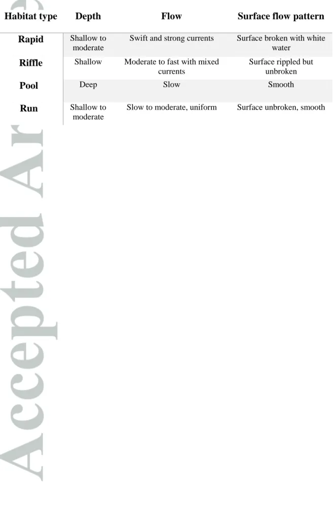
Between August 5th and 28th 2007, during stable low flow conditions, the Matapedia River was surveyed to assess presence-absence of D. geminata mats along a 65 km-long section of the river. Along the longitudinal transect, each channel unit was classified into homogeneous mesohabitat types according to bed topography and low water surface flow facies as defined in Frissell et al. (1986). Habitat types were categorized in terms of depth, substrate and velocity, as either rapids, runs, pools or riffles (Table 2). Within each unit, we assessed substrate composition, channel width and depth as well the occurrence of D. geminata mats. Visual surveys of D. geminata mat presence-absence were conducted with a viewfinder from a canoe.
Didymo Monitoring Network (DoMiNo) development and quality control
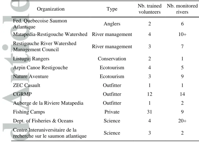
To develop an effective monitoring network, we approached key organizations involved in Atlantic salmon fisheries that were keen to understand how this nuisance alga affected fish habitat and potentially the local economy. Recruitment of these partners (e.g. fishing/hunting
technicians, see Table 1) helped define monitoring site locations. While aiming for a well distributed sampling effort, care was taken to make it possible for volunteers to include data collection in their daily routine. This approach yielded a high participation rate amongst targeted groups and promoted volunteer retention through the duration of the study. Within the Restigouche River watershed, the network currently involves 70 volunteers from 22 different key organizations with an interest in Atlantic salmon conservation.
DoMiNo Volunteer Booklet
To assist volunteers in the proper collection of data, an English and French educational booklet was developed. First, the text addressed the importance of the monitoring network and reminded volunteers of the importance of this effort towards the advancement of D.
geminata research. It also provided information on the general biology and ecology of the
diatom and described how their efforts would be integrated in research questions and objectives. The data collection protocol was presented into detail to remind participants how observations should be collected. The protocol involved a visual classification of D. geminata presence into five different categories of percentage of bed coverage by D. geminata in increments of 20%. To limit biased estimates of mat coverage, photographs, representative of each category, were provided in the photo-guide section of the booklet. One representative measurement of mat thickness was then determined with a ruler. Pre-formatted waterproof data sheets (figure 2) were provided to ensure that all relevant information was collected (i.e. name of the observer, date, location, percent cover category, thickness and type of coverage (mats or tufts) and allowed for consistency in data collection among volunteers.
Training
At the beginning of each monitoring summer, participants of each organization took part in an interactive training session where they were taught how to identify D. geminata
adequately, how to use the monitoring network booklet and collect data. When possible, volunteers were also accompanied in the field by the authors to conduct live search and identification of D. geminata. As recommended by Bonter & Cooper (2012), frequent follow-ups (i.e. communication and field visits) were conducted throughout the sampling period to ensure proper monitoring, data quality and limit inter-operator variability (Kilroy et al. 2013).
Data collection
Between 2010 and 2015, volunteers gathered weekly observations of D. geminata mat coverage and thickness data with their DoMiNo booklet in their assigned sites between mid-May and late October of each year. Each organization then forwarded the information on a fortnight basis for data quality control and compilation. Thus, data reported by volunteers was frequently validated by field visits and/or by corroborating estimations with supplemental photos. Moreover, all newly reported affected reaches (first positive report for a given watercourse) were visited by the authors. Per year, we visited, on average, 25% of the monitored sites for in-field validation of D. geminata percent cover and thickness. All validated observations were geo-referenced. Over the course of six monitoring periods (2010-2015), volunteers gathered 1228 validated observations of D. geminata mat severity throughout the Restigouche River.
Data analysis
Reach scale occurrence of D. geminata mats
A contingency table of the frequency of occurrence of D. geminata mats within each habitat type was developed for the 2007 survey data. Pearson’s chi-square test was applied to the frequency data of D. geminata mats in relation to habitat type and substrate and used to highlight habitat preferences for mat formation.
Mat severity: Standing Crop Index
When each visual observational data was compiled into the regional database, a Standing Crop Index (SCI) value was calculated by multiplying the thickness of the D. geminata mat by its percent areal coverage. This method was initially developed by Kilroy (2006) and enables the production of a standardized metric that can be compared across local, regional, national and international scales (Kilroy and Bothwell 2012). In this manuscript, we use the Standing Crop Index as a proxy defining D. geminata mat severity.
Mapping
Standing Crop Index (SCI) observations spanning six monitoring periods (2010-2015) were used to map D. geminata inter-annual variability throughout the watershed. For each year, maps were created by interpolating the SCI values, constrained to areas for which observations existed, along the river network. Sites comprising multiple values per monitoring period were averaged to provide mean SCI throughout the monitoring period. Inverse distance weighting (IDW) was applied in a stream-wise direction using a kernel of radius 2.5 km to ensure that interpolated values did not substantially stray outside the limits of the observed data points. Interpolated SCI values were classified according to nuisance periphyton criteria (Kilroy & Wech, 2012), where green denotes ‘good’ status (SCI below 200), amber denotes ‘alert’ status (SCI between 200 and 600) and red (SCI above 600) denotes that a management response is required. This method was used as an effective management tool on the Lower Waiau River in New Zealand by characterizing occurrence and severity of D. geminata mats (Kilroy & Wech, 2012). Inter-annual variation and spatial distribution of D. geminata mat severity was subsequently quantified by calculating the percentage composition of mat coverage in terms of these three severity classes as well as by computing the mean SCI across the entire watershed for each summer monitoring period.
Analysis-of-variance (ANOVA) was used to determine whether SCI values varied significantly between streams of different Strahler order.
Hydrological data
Annual discharge conditions within the Restigouche watershed were examined to identify potential mechanisms responsible for inter-annual variability in D. geminata mat coverage falling into each of the three severity classes (green-yellow-red). Daily discharge data were assembled by combining records from two gauging stations located towards the confluences of the Matapedia and Restigouche sub-basins (Environment Canada ID 01BD009 and 01BJ007 respectively). A series of simple regression analyses (linear, exponential, power) was used to explore correlations between D. geminata mat severity and a range of hydrological metrics. These metrics comprised mean, minimum and maximum annual discharge, peak spring discharge (defined as maximum daily discharge between February 1st and May 31st), number of high discharge events (defined as the number of days where discharge exceeded a predefined threshold of 65 m3s-1) and number of days since flood. If regression analysis indicated the existence of a correlation between D. geminata severity and a given hydrological metrics, a two sample Kolmogorov-Smirnov test was used to compare distributions of hydrological parameters and SCI.
Results
Reach scale variability of D. geminata mat occurrence
Frequency of D. geminata mat occurrence was determined visually for each habitat type (Figure 5) in 2007. Visual presence-absence data showed that the occurrence of mats was dependent on the various habitat types (i.e. rapids, runs, pools and riffles) indicating a strong habitat preference for riffles (χ2 (3, N= 276), p < 0.05). Conversely, D. geminata presence was not dependent on substrate type within riffles (χ2 (3, N= 123), p > 0.05).
Inter-annual variability of D. geminata mat severity
Data collated between 2010 and 2015 was analyzed and severity maps were created to highlight the yearly spatial variability of D. geminata mat severity throughout the Restigouche River watershed (Fig. 3). Table 3 presents the yearly proportion of D. geminata mat severity per class. D. geminata mat severity was highly spatially variable between monitoring periods. D. geminata mats were most severe in 2013 (14.7% of sites under red status). Conversely, D. geminata mats were less severe in 2010, 2011, 2014 and 2015, where the percentage of sites under green status was the highest throughout the time series. This trend was observed throughout the watershed across all monitored reaches (Strahler’s stream order varying from 4 to 8). One-way analysis of variance (ANOVA) showed that mean SCI values did not vary significantly between stream order.
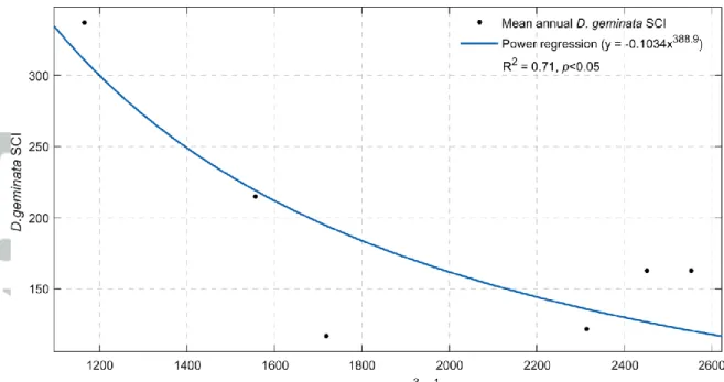
Of the various hydrological metrics, maximum spring discharge was the only one that exhibited a significant correlation (p < 0.05) with SCI (i.e. D. geminata mat severity) under any of our regression analyses (linear, exponential, power). Using a power regression model (fig 4), maximum spring discharge (Qmax) explained 71% of the observed variability in SCI
(R2 = 0.71, p < 0.05). Furthermore, the distributions of mean SCI and maximum spring discharge differed significantly (two-sample KS test: p < 0.05) indicating that when maximum spring discharge is high, severity of D. geminata mats in the following months will be significantly lower.
Data quality
Over the course of six monitoring periods, less than 2% of the data needed to be corrected due to over or underestimation of D. geminata mat severity following field visits and/or
photo validation. Furthermore, D. geminata was misidentified on only three occasions where another stalk-forming diatom, i.e., Cymbella sp. was mistaken for D. geminata.
Discussion
In this study, the creation of a didymo monitoring network allowed for the development of a comprehensive dataset describing the spatial and temporal distribution of D. geminata in the Restigouche River watershed between 2010 and 2015. The time and effort spent training volunteers resulted in an extensive dataset of reliable observations that could not have been obtained otherwise through a conventional monitoring program, which clearly demonstrates that citizen science can help further the understanding of this nuisance species.
Factors driving D. geminata mat occurrence and severity
At the reach scale, our results indicate that the spatial variability in D. geminata mat coverage was explained by habitat characteristics. D. geminata mats were occasionally found in runs and pools, but were most prevalent in riffles. They were however almost completely absent from rapids. Rapids may render unsuitable conditions due to high shear stress and higher frequency of bed load transport causing mat scouring whereas light availability is limited in deeper pools. This result supports previous observations that geomorphological units define physical habitat suitability for mat colonization and growth (Cullis et al. 2015; Miller et al. 2009). Runs and riffles offer optimal conditions for D. geminata colonization, mat development and persistence due to their shallow depths, high light availability and stable substrate between high discharge events.
At the watershed scale, analysis of the correlation between the mean annual SCI against multiple hydrological metrics showed that maximum spring discharge best explained inter-annual variability in SCI. As a corollary, high maximum spring discharge was associated
with a lower proportion of “red” or “orange” status for 2011, 2014 and 2015. For example, 2011 was characterized as a “wet” year and D. geminata was found to be limited within the basin. In comparison, 2010, 2012 and 2013 were dryer years in eastern Canada with fewer high-flow events that may have limited D. geminata growth and mat establishment. Our findings are in accordance with Richardson et al. (2014) who found that inter-annual variability of the hydrological regime and higher peak flows limited D. geminata density. In our study, maximum spring discharge was the only hydrological factor to have a significant effect on D. geminata mat severity. Conversely, in New Zealand, Kilroy & Wech (2012) found that the number and duration of floods above 65 m3s-1 were significantly correlated with the percentage of time that surveys yielded a green status due to reach-scale scouring. They also showed that the number of days since a flood occurred best explained the amount of time under red status. Recent work by George & Baldigo (2015) found that the frequency of high-flow events significantly decreased stalk biomass.
Data reliability and limitations
The quality of data collected by citizen science initiatives is often criticized. However, good quality data can be ensured by proper sampling design, standardized methods and appropriate training (Yoccoz et al., 2003, Delaney et al., 2007, Schmeller et al., 2009). Kilroy et al. (2013) found that assessments of visual periphyton surveys by multiple participants was not a challenging issue if given proper training. A review by Crall et al., (2010) also highlighted that appropriate training can provide ample scientific skills for neophyte volunteers to collect required data. As in Dickinson et al. (2012), the availability of an educational tool (here the monitoring network booklet) promoted and facilitated the collection of appropriate data while maintaining awareness and reminding users of the importance and relevance of their efforts.
Quality control of citizen science data is however a necessary step to validate data consistency and reliability (Bonter & Cooper 2012).
Citizen science datasets are defined by sampling efforts and by the spatial distribution of monitored sites. Thus, resulting distribution patterns are substantiated by the fact that “absence of evidence is not evidence of absence” (Altman & Bland 1995), and suggest a probable underestimation of the documented phenomenon. It is therefore considered that the visual monitoring efforts carried out by volunteers do not discount watercourses of absolute
D. geminata presence. Nevertheless, this effort offers good insights on the broad scale
occurrence of D. geminata across landscapes and the authors are confident that the data obtained ensured an efficient monitoring of D. geminata mats. In parallel, this type of extensive monitoring data can help define regional trends in occurrence and severity by comparing existing ancillary physical and chemical data of affected and non-affected reaches.
Conclusion
The Didymo Monitoring Network was the first network to be developed to monitor the occurrence and severity of D. geminata mats. Following this initiative, other organizations are now effectively monitoring D. geminata by training and involving volunteers (e.g. The New Hampshire Rivers Council’s River Runners; the Three Rivers Community College’s
Citizen’s River Monitoring Program; the Trout Unlimited Discovering Didymo Distribution
using the iNaturalist app piloted by the University of Calgary and the University of North Carolina). These project schemes offer potential for partnership and future collaborative efforts will be pursued to enhance our current liked-minded projects across landscapes, state and international boundaries. Yielding a higher standardized sampling effort at greater
geographical scales will contribute to the production of a robust dataset enabling ecological modelling of D. geminata. Cell vouchers may also be useful in monitoring programs towards increasing quality control and validation of recorded observation data by microscopic identification of cells.
Mapping the severity and distribution of nuisance growths throughout the Restigouche River watershed helped managers and local stakeholders comprehend factors explaining the observed yearly variability. Although hydrological metrics alone cannot define D. geminata’s habitat window (Cullis et al., 2012) nor entirely account for observed seasonality and yearly variability (Kilroy & Wech, 2012; Kirkwood et al., 2007), this study highlights trends in inter-annual SCI variability driven by the hydrological regime. A more comprehensive look at D. geminata seasonality is needed to highlight the importance of hydrological metrics driving site-specific changes in SCI values. Furthermore, an assessment of the relative importance of other intrinsically related variables to discharge such as temperature and light availability is needed to better define yearly and seasonal trends as well as defining D.
geminata’s habitat window for colonization, growth and persistence of nuisance growths in
eastern Canada. Future research efforts should focus on developing tools for assessing the severity of D. geminata nuisance growths by incorporating the timing, duration and proportion of affected vs. non-affected habitats. This biomass assessment may then be incorporated in D. geminata ecosystem impact studies.
Acknowledgements
This project would not have been a success without the participation of many volunteers and stakeholders wary of Atlantic salmon conservation and local economy. Thank you for being curious and devoted. This effort has been aided by financial support provided by Mr Gaston Lepage through his donation to the Fondation de l’Université du Québec (FUQ). Additional
funding was provided by the Atlantic Salmon Conservation Foundation (ASCF) and the New-Brunswick Wildlife Trust Fund (NBWTF). Carole-Anne Gillis was funded by NSERC-FRQNT BMP-Innovation grant through collaboration and support by the Matapedia-Restigouche Watershed Organization. Thanks to the Conseil de l’eau Gaspésie-Sud and the Restigouche River Watershed Management Council for supplemental support. Many thanks to Anne Provencher St-Pierre for her support during the creation of this monitoring network, to Daniel Caissie for commenting an earlier version of the manuscript and to Jordane Clermont and Danielle Frechette for their support with the dataset and analysis.
References
Altman DG & Bland JM (1995) Absence of evidence is not evidence of absence. British
Medical Journal 311(7003):485.
Beville ST, Kerr GN & Hughey KFD (2012) Valuing impacts of the invasive alga
Didymosphenia geminata on recreational angling. Ecological Economics 82(0):1-10. Biggs BJF (1996) Patterns in benthic algae of streams. Stevenson RJ, Bothwell ML & Lowe
RL (Eds.) Algal Ecology, Academic Press, San Diego, CA.
Bonter DN & Cooper CB (2012) Data validation in citizen science: a case study from Project FeederWatch. Frontiers in Ecology and the Environment 10(6): 305-307.
Chopyak J & Levesque PN (2002) Community-Based Research and Changes in the Research Landscape. Bulletin of Science, Technology & Society 22(3): 203-209.
Crall A, Newman G, Jarnevich C, Stohlgren TJ, Waller DM & Graham J (2010) Improving and integrating data on invasive species collected by citizen scientists. Biological
Invasions 12(10): 3419-3428.
Cullis JDS, Gillis C-A, Bothwell ML, Kilroy C, Packman A & Hassan M (2012) A conceptual model for the blooming behavior and persistence of the benthic mat-forming diatom Didymosphenia geminata in oligotrophic streams. Journal of
Geophysical Research. 117(G2):G00N03.
Cullis JDS, Spaulding SA & McKnight DM (2015) Hydrodynamic Control of Benthic mats of Didymosphenia Geminata at the Reach Scale. Canadian Journal of Fisheries and
Aquatic Sciences 72(6):902-914.
Delaney D, Sperling CD, Adams CS & Leung B (2008) Marine invasive species: validation of citizen science and implications for national monitoring networks. Biological
Invasions 10(1): 117-128.
Dickinson JL, Shirk J, Bonter D, Bonney R, Crain RL, Martin J, Phillips T & Purcell K (2012) The current state of citizen science as a tool for ecological research and public engagement. Frontiers in Ecology and the Environment 10(6): 291-297.
Frissell CA, Liss WJ, Warren CE & Hurley MD (1986) A Hierarchical Framework for Stream Habitat Classification: Viewing Streams in a Watershed Context.
Environmental Management 10(2):199-214.
George SD & Baldigo BP (2015) Didymosphenia geminata in the Upper Esopus Creek: Current Status, Variability, and Controlling Factors. PLoS ONE 10(7):e0130558. Gillis C-A & Chalifour M (2010) Changes in the macrobenthic community structure
following the introduction of the invasive algae Didymosphenia geminata in the Matapedia River (Quebec, Canada). Hydrobiologia 647(1):63-70.
Harding JS, Clapcott JE, Quinn JM, Hayes JW, Joy MK, Storey RG, Greig HS, Hay J, James T, Beech MA, Ozane R, Meredith AS & Boothroyd IKD (2009) Stream habitat assessment protocols for wadeable rivers and streams of New Zealand. University of Canterbury Press, Christchurch.
Kilroy C (2006) Ecological studies on Didymosphenia geminata. NIWA Client Report CHC2005-123, 79 p.
Kilroy C & Wech J (2012) Managing nuisance periphyton in the Lower Waiau River: update for 2011-2012. NIWA Client Report CHC2012-064.
Kilroy C & Bothwell ML (2012) Didymosphenia geminata growth rates and bloom formation in relation to ambient dissolved phosphorus concentration. Freshwater Biology
57(4):641–653.
Kilroy C, Booker D, Drummond L, Wech JA & Snelder TH (2013) Estimating periphyton standing crop in streams: a comparison of chlorophyll a sampling and visual
assessments. New Zealand Journal of Marine and Freshwater Research 47(2): 208-224.
Kirkwood AE, Shea T, Jackson L & McCcauley E (2007) Didymosphenia geminata in two Alberta headwater rivers: an emerging invasive species that challenges conventional views on algal bloom development. Canadian Journal of Fisheries and Aquatic
Sciences 64(12):1703-1709.
Larned ST, Arscott D, Blair N, Jarvie B, Jellyman D, Lister K, Schallenberg M, Sutherland S, Vopel K & Wilcock B (2007) Ecological studies of Didymosphenia geminata in New
Zealand, 2006-2007. NIWA Client Report CHC2007-070, 127 p.
Lodge DM, Williams S, MacIsaac HJ, Hayes KR, Leung B, Reichard S, Mack RN, Moyle PB, Smith M, Andow DA, Carlton JT & McMichael A (2006) Biological invasions: recommendations for US policy and management. Ecological Applications
16(6):2035–2054
Miller MP, McKnight DM, Cullis JDS, Greene A, Vietti K & Liptzin D (2009) Factors controlling streambed coverage of Didymosphenia geminata in two regulated streams in the Colorado Front Range. Hydrobiologia 630(1):207-218.
Richardson D, Oleksy I, Hoellein T, Arscott D, Gibson C & Roots S (2014) Habitat
characteristics, temporal variability, and macroinvertebrate communities associated with a mat-forming nuisance diatom (Didymosphenia geminata) in Catskill mountain streams, New York. Aquatic Sciences 76(4):553-564. doi: 10.1007/s00027-014-0354-7
Schmeller DS, Henry P-Y, Julliard R, Gruber B, Clobert J, Ziock F, Lengyel S, Nowicki P, Déri E, Budrys E, Kull T, Tali K, Bauch B, Settele J, Van Swaay C, Kobler A, Babij V, Papastergiadou EVA & Henle K (2009) Advantages of Volunteer-Based
Biodiversity Monitoring in Europe Ventajas del Monitoreo de Biodiversidad Basado en Voluntarios en Europa. Conservation Biology 23(2): 307-316.
Spaulding SA & Elwell L (2007) Increase in nuisance blooms and geographic expansion of the freshwater diatom Didymosphenia geminata. Open-file report 2007-1425 (U.S. Geological Survey,, Reston, Va.), p iv, 38 p.
Yoccoz NG, Nichols JD & Boulinier T (2003) Monitoring of biological diversity - a response to Danielsen et al. Oryx 37(4):410.
Table 1. Overview of organizations monitoring the occurrence and severity of D. geminata
mats throughout the Restigouche River watershed
Organization Type Nb. trained
volunteers
Nb. monitored rivers Fed. Quebecoise Saumon
Atlantique Anglers 2 6
Matapedia-Restigouche Watershed River management 4 10+ Restigouche River Watershed
Management Council River management 3 7
Listuguj Rangers Conservation 2 1
Arpin Canoe Restigouche Ecotourism 4 5
Nature Aventure Ecotourism 3 9
ZEC Casault Outfitter 1 1
CGRMP Outfitter 12 14
Auberge de la Riviere Matapedia Outfitter 1 2
Fishing Camps Private 31 9
Dept. of Fisheries & Oceans Science 4 20+
Centre Interuniversitaire de la
Table 2. Definitions and features of categorized habitat types. Adapted from
Harding et al. (2009)
Habitat type Depth Flow Surface flow pattern
Rapid Shallow to
moderate
Swift and strong currents Surface broken with white water
Riffle Shallow Moderate to fast with mixed
currents
Surface rippled but unbroken
Pool Deep Slow Smooth
Run Shallow to
moderate
Table 3. Proportion of D. geminata mat severity comprising each class per monitoring
period in relation to maximum spring discharge
Percent proportion of SCI levels
2010 2011 2012 2013 2014 2015 Low (<200) 80,1 81,9 65,6 66,0 84,3 89,8
Medium (200 - 600) 15,5 9,9 25,9 19,3 8,8 4,1
High (>600) 4,4 8,2 8,5 14,7 7,0 6,0
Figure 1. Large growths of D. geminata mats in the Duval River, a tributary of the
Figure 2. Data collection sheet used by the volunteers to monitor D. geminata percent
Figure 3. Maps of interpolated D. geminata mat severity throughout six monitoring periods
between 2010 (A) and 2015 (F). Severity scale is presented in map A and color classification is based on Kilroy & Wech (2012); Table 3.
Figure 4. Power regression model of mean annual D. geminata SCI in relation to
Figure 5. Frequency of D. geminata mat presence (dark grey) and absence (light grey) in