HAL Id: hal-01025668
https://hal-brgm.archives-ouvertes.fr/hal-01025668
Submitted on 18 Jul 2014HAL is a multi-disciplinary open access
archive for the deposit and dissemination of sci-entific research documents, whether they are pub-lished or not. The documents may come from teaching and research institutions in France or abroad, or from public or private research centers.
L’archive ouverte pluridisciplinaire HAL, est destinée au dépôt et à la diffusion de documents scientifiques de niveau recherche, publiés ou non, émanant des établissements d’enseignement et de recherche français ou étrangers, des laboratoires publics ou privés.
Numerical model for assessment of subsidence due to
dissolution of salt, application to Nancy Basin (East of
France)
Sébastien Gourdier, Behrooz Bazargan-Sabet
To cite this version:
Sébastien Gourdier, Behrooz Bazargan-Sabet. Numerical model for assessment of subsidence due to dissolution of salt, application to Nancy Basin (East of France). IMWA 2014 Interdisciplinary Responses to Mine Water Challenges, Aug 2014, Xuzhou, China. �hal-01025668�
Numerical model for assessment of subsidence due to dissolution
of salt, application to Nancy Basin (East of France)
Sébastien Gourdier1, Behrooz Bazargan Sabet2
1 BRGM, France, s.gourdier@brgm.fr
2 BRGM and Université de Lorraine, France, b.bazargan-sabet@brgm.fr
Abstract
Long term evolution of salt mine depends on elasto-viscoplastic behavior of the material but also on specific conditions like the intrusion of water into working areas. Such phenomenon has been observed in the Nancy Basin where brine percolates through access shafts accompanied by significant subsidence at the surface level.
In order to understand the mechanism that governs groundwater movement and to analyze the kinetics of dissolution of salt inducing the phenomenon of subsidence, a numerical model is implemented. The circulation of water between different layers is simulated allowing the assessment of evolution of salt mass dissolution with time.
Key words: Salt mine, Subsidence, Dissolution, Model
Introduction and context
Nancy Basin is heavily constrained in terms of urban development because of past salt mining activities on its territory which are responsible for subsidence and structure damages.
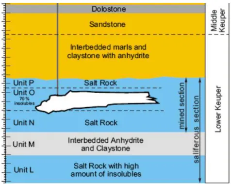
Lorraine subsurface consists in an important Lower Keuper saliferous deposit which is 100 to 150 meters thick with a dip of a few degrees (Saunier and Courrioux 2008). Under river beds, the saliferous formation roof is 50 meters deep. The lithostratigraphic section of the Lower Keuper formation is presented on fig. 1.
The saliferous part of the Lower Keuper formation is divided into five layers with similar thicknesses (25 to 30 meters) but very different concentration in salt. The salt deposit has been industrially mined for 150 years in Nancy Basin, at the confluence of Meurthe and Sânon rivers, 12 km South-East of Nancy City.
The mechanism of dissolution is likely related to rainwater percolation through the overburden towards the salt deposit roof. The latter is impervious to water, therefore groundwater flows towards its outlets (springs or rivers) while leaching the saliferous layers top. It is estimated that 30,000 tons of salt are rejected in the surface water system each year (Lebon 1987).
Salt dissolution creates voids which lead to subsidence at the surface. Due to social constraints, the region is the object of regular and diverse monitoring. This allows gathering essential in situ measurements in order to improve knowledge on the mechanical and dynamic behavior of the area and its evolution. Vertical displacements have been measured regularly for 40 years and subsidence is estimated between 30 and 60 mm/year
Dissolved salt thickness can be locally very important. The intensity of dissolution occurring at the contact between salt deposit and overburden varies according to the location: dissolution is very active where a rich layer is in contact with groundwater. 1st and 3rd layers present a high concentration in salt, whereas 2nd and 5th are quite poor (40 to 50 %) and 4th one is sterile.
This mechanism existed prior to mining operations and explains the presence of Dombasle saline aquifer which is not an aquifer stricto sensu. It is actually a network of anastomotic dissolution channels, separated by contact zones between the saliferous deposit and its overburden (Nguyen-Thé 2009).
During mining activities, the equilibrium of the system has been probably disturbed, allowing the reactivation of the dissolution processes.
Several boreholes have been drilled to observe the structure of these channels which do not exceed 20 cm in thickness. Channels mechanical behavior has been investigated through modeling. The calculations show that open channels must be less than one meter wide, otherwise they would collapse. The results of these investigations are consistent with the measurements, notably with the estimation of the subsidence rate. In active dissolution zones, this network constantly evolves: new channels appear with new dissolution zones while others collapse because of their too important dimensions.
In situ experimentations show that this groundwater system presents a high transmissivity. Isotopic
dating of groundwater shows that these saline waters are “young”: 1 to 4 years old. They come from natural infiltration of rainwater which percolates later through mineshafts.
Figure 1 Nancy Basin lithostratigraphic section.
Model
Due to its geometric complexity (evolving channel network) and historical context (several periods and methods of mining), the whole hydrogeological system of the Nancy Basin cannot be investigated by a unique model, which would be impossible to handle and calibrate. Thereby in a first approach we focus on modeling one dissolution channel as an elementary part of a more complex system.
Dissolution channel modeling has been realized using COMSOL Multiphysics® with Darcy’s Law and Solute Transport interfaces. COMSOL Multiphysics® is a general-purpose software platform, based on advanced numerical methods, for modeling and simulating various physics and engineering problems, especially coupled phenomena (Comsol Manual 2011).
From a geometrical point of view, the model consists in a 200 m long and 10 cm thick area which reproduces a typical dissolution channel. The mesh is “extremely fine” according to COMSOL terminology and counts a little more than 6,000 elements.
Hydraulic conductivity (K) of the dissolution channel is between 10-3 and 10-4 m/s, its porosity is 100 % and the applied hydraulic gradient (h) is between 0.4 and 0.5 %.
Boundaries conditions consist in:
hydraulic heads imposed at the upstream (left) and downstream (right) boundaries, to obtain the desired hydraulic gradient;
a no flow condition at the upper boundary; a concentration in salt of 316 kg/m3
The simulations are carried out considering a steady state hydrodynamic regime and a transient state solute transport regime during four years.
Results
In steady state with homogenous hydrodynamic properties, the Darcy’s velocity field is constant and equals to the hydraulic conductivity multiplied by the hydraulic gradient.
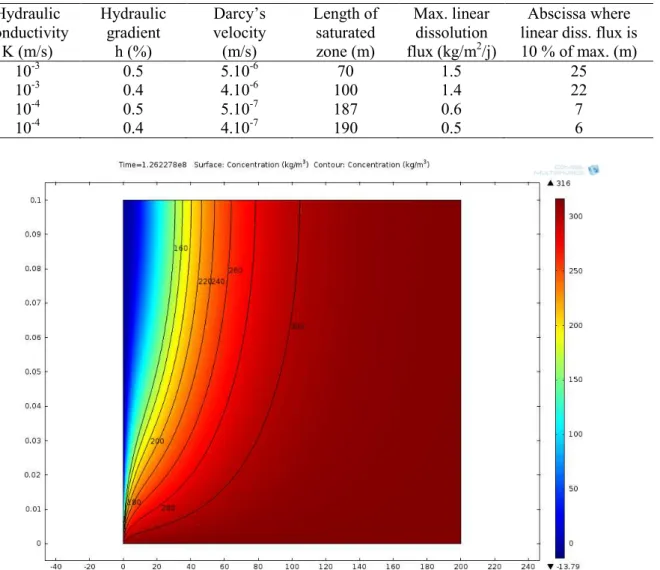
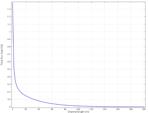
Calculations show that in every case, the transient period does not exceed two years. Solute transport steady state, after two years, allows reaching a total mass of 5,500 kg of salt transported by dissolution. Concentration field (fig. 2) and dissolution flux at the contact surface (fig. 3) depend on Darcy’s velocity in the dissolution channel. Results for different configurations (i.e. combinations of K and h) are given in tab. 1.
Table 1 Results of simulations.
Hydraulic conductivity K (m/s) Hydraulic gradient h (%) Darcy’s velocity (m/s) Length of saturated zone (m) Max. linear dissolution flux (kg/m2/j) Abscissa where linear diss. flux is 10 % of max. (m)
10-3 0.5 5.10-6 70 1.5 25
10-3 0.4 4.10-6 100 1.4 22
10-4 0.5 5.10-7 187 0.6 7
10-4 0.4 4.10-7 190 0.5 6
Figure 2 Calculated concentration field (hyd. cond. = 10-3 m/s, hyd. gradient = 0.4 %). Discussion – Conclusion
The results presented in this paper are relative to the preliminary modeling of the dissolution mechanism observed in Nancy Basin region.
Despite the simplicity of this model, realistic parameters used as input data gave raise to output results consistent with the expected range of values.
An important result obtained with this modeling work is the numerical assessment of the transient period that cannot exceed two years in the case of the Nancy Basin. This means that further predictions of solute transport targeting long term behavior can be made assuming a steady state, which dramatically simplifies the constitutive model.
It must be noted that by integrating the curve obtained in fig. 3 over the model length, it would be possible to adjust the calculation parameters to obtain observed mass flux (i.e. 30,000 tons / year). However, due to the geometric complexity of the system, we do not think that this adjustment can be representative of the real situation.
Further works will intend to represent the whole system by combining elementary models based on dimensions and positions of channels deduced from the geometry of surface subsidence.
Figure 3 Calculated dissolution flux at lower boundary (hyd. cond. = 10-3 m/s, hyd. gradient = 0.4 %). Acknowledgements
This study was entirely funded by BRGM under its missions of research and public services.
References
Introduction to Comsol Multiphysics® (2011)
Lebon P (1987) Etude des risques de mouvements de terrain, secteur de St-Nicolas de Port – Dombasle. Phase 1: Etude d’environnement des phénomènes de dissolution des formations salifères, rapport BRGM 87 SGN 218 LOR
Nguyen-Thé D (2009) Synthèse hydrogéologique du bassin salifère de Dombasle, Rapport final BRGM/RP-57615-FR
Saunier M, Courrioux G (2008) Synthèse géologique du bassin salifère de Dombasle (Meurthe-et-Moselle). Rapport final. BRGM/RP-56501-FR