"14-17 October 2008, Antalya-TURKTYE"
1f1h Internatlona! Congress on Mechanizatlon and Energy ln Agriculture
CRA-W's Committee of Intervention: Analyse of Catchments Polluted
with Pesticide
the publlc body ln charge of water protection (SPGE) put the Agricultural Research Center of Wallonla (CRA-W) ln charge of developlng a pollution of pesticide diagnosls method and proposlng protection measures, site by site. A committee of intervention has been created to Invest/gate and to propose solution to resolve the problem of pesticide pollution at the catchments used for drinking water production. This committee ls composed by pedologlsts (FUSAGX), hydrogeologlsts (FUNDP), agrometerologlsts, geomatic1an (BGDA) and agricultural englneer ln charge of coordination (CRA-W).
This paper presents the pUot study carrled on ln October 2006 and that leads thls committee to develop and improve a specifie methodology. Stéphanie NOEL', Boubacar Bilia BAH', Gilles COLLINE"', Dominique BUFFET", Bruno
HUYGHEBAERr, Aurélie SOREL4,Vincent HALLET'
1Engineering Dept., Agrlcultural Research Centre of Wallonla (CRA-W), 5030 Gembloux, Belglum
2Laboratory of geopedology, Ç.1embloux agrlcultural UnIversity, 5030 Gembloux, Belglum
JBiometry, data processlng and agrometeorology Unit, Agrlcultural Research Centre of Wallonia (CRA-W), 5030 Gembloux, Belglum
4Geology Department, University of Namur, 5000 Namur, Belgium E-mail: noel@cra.wallonle.be
Abstract: In the Walloon Region of Belgium, a commlttee of Intervention has been created to Investigate problems of pesticide contamination of various catchments use for drinking water production. This commlttee Involves the Agricultural Research centre - Wallonla (CRA-W, project coordinator) and sorne University experts.It ls funded by the Société Publique de Gestion des Eaux (SPGE). The diagnosis method, base on the AQUAPlAlNE method (Arvalis - France), conslsts of 4 steps. The first step Is the preparation of diagnosls (at the office) that takes into account the paper r1sk of active ingredients. and thelr uses, the identification of the agrtcultural parcels, the collection of cartographie and numeric data, the description of the hydrogeological and pedological contexts and the study of the meteorologlcal data ln relation with the period of pollution. The second step conslsts of maklng a plot diagnosls (on the field) ta Identify the way of transfer inside the plot and collecting data. At the thlrd step, the people who can apply ppp treatment close to the catchment are met (farmers and city services). Information are coJ!ected on treatments applied and on the state of parcels. Based on the hypathesls of pollution cause, the committee proposes solution to solve the problem. One of the catchment that has been investigated by the commlttee is located at Biesmerée, (Namur province, ln Belglum). A temporally contamination was caused by 4 pesticides: chlortoluron, isoproturon, trifluralln and diflufenlcan. After Investigations, it seems that the pollution was probably due ta the hydrogeologlcal context .Asthe river Is locally perched over the aqulfer, the presence of Poly-aromatic hydrocarbons (PAHs) couldbedue ta the Infiltration of surface water Inside the catchment or/and to the presence of a sinkhole temparaHy activated durlng river flood period. Infiltration rate has ta be assessed and river bank Impermeabilization Is recommended
Key ward: pesticide, catchment, Commlttee of intervention. INTRODUCTION
In the south part of Belgium, 80%of the drinklng water production comes from the ground water. The pollution caused by pesticide increases each year (EEW, 2007).50between 2000 and 2007, 16% of the catchments have been contamlnated by pesticide, once upper than the drlnklng water standard of O.ljJg/1. Catchments pollution Increase the cost of production, due to the remedlation treatment.
To protect the catchment, protection area must be located around them. Into these areas, special legislations are taken Into consideration ta Iimlt the risk of poHutlon by pesticide. Nevertheless, the situations are very variable and global measures seem ta he Ineffldent. 50 specifie measures should be consldered and adapted case by case. In thls context,
lrF'
International Congress on Mechanlzatlon and Energy in Agriculture~14-17Odober 200llj Antalya-TURKIYE"
MATE RIALS AND METHDDS
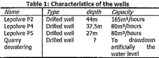
The catchment studied is located ln Biesmerée area (Mettet) ln the Namur Province. The groundwater Is pumped from 3 wells called: lepoivre P2, lepoivre P4 and Lepoivre PS (Tablel), located ln an abandoned Iimestone quarry.
Due to the quarry floor altitude that Is located below the plezometer level, constant dewatering is necessary. This creates a drawdown cone of more than 600 meters wide, extended below the rIVer Stave (Figure 2). Due to the pumplng and ta the dewatering, the Stave River is perched. 5eepage could occur according the alluvial deposit permeabllity and risks of groundwater contamfnation are hlgh.
Table 1: Characteristlcs orthe wells Figure 1: Concentrations of pesticides Inside the weil "Lepoivre P4"
! _ j / +
-j
~+---~\\~
+---tA,\-'-\\
...
'=.""~ respectively, 1.682JJ9/1, 0.4676JJ9/1, 0.145J.l9/1and 0.816 1J9/1 of chlortoluron, Isoproturon (IP), diflufénican (OFF) and trifluraHne (Figure 1).The committee studied the cause of this pollution usfng a method based on the AQUAPLAINE diagnosis method developed by Arvalis (Institut du végétal, France) consfstlng of 4 steps (Arvalis, 2003):
Preparing the diagnosis usfng existing Information.
- Plot d!agnosls uslng data bank completed by field observations.
- Meeting and discussion with pesticide users. - Anal diagnosis and remediatlon proposaI.
71 deth
ca
dDriUed weil 44m 16Sm3/hours
Drilled weil 37.5m SOm3jhours
Drilled weil 27m SOm3jhours
Driiled wen ? To drawdown artificially the water level Name lepolvre Pl lepolvre P4 lepolvre PS Quarry dewaterlng
Figure 2: Site location and means observations carry on the fist step of the dlagnosls
lf1h Internat/onal Congress on Mechanlzatlon and Energy ln Agriculture
~14-17October 200/tAntalya-rURKlYe
RESEARCH RESULTS
First step:
Preparing
the
diagnosis
using
existing data
The first step consists of gatherlng the avallable data, to prepare a useful and efficient field visit, information regardfng:
~ Pesticide general Information (use, application period, paper riskl analysis results, ...).
Landscape and the fields envlronment (agrîcultural parcelsl coverage, key elements of the
landscape, cartographie data on the site, on the geology, hydrogeology and pedology context, ...)
Meteorological data (precipitation, evapotransplration and field capacity).
the four active Ingredients (a.i.) implicated ln the pollutron are used spe<:ially as cereal herbicide. Their application could be carried out ln pre-emergency (in spring) of in post-emergency (in autumn) depending on the type crop and the active Ingredients. Isoproturon and chlortoluron presenting the same action spectrum are not usually applied together. These a,i, could be applled apart, in association \Vith diflufenican of trmuraline to broaden the spectrum.
Based on paper rlskl the chlortoluron and
lsoproturon present an Important rîsk of. ground water contamination according to Groundwater Ublquity
Score (GUS) (IUPAC,1995). In fact these a.i. are usually detected in Wallonla, whlch is not the case of dlflufenican and trifluraUne, accordlng to their low GUS value.
At Biesmerée, protection areas have been defined according to the Walloon legislation. These areas conslst of 3 zones:
~Catchment area or zone 1: c10sed area owned by the water producerl its extension is 10 meter around
the catchment site.
~ Nearby orotection area or zone lIa: Inside this zone, a pollution of groùndwater takes 24 hours ta reach the catchment.
v Distant protection area or zone lIb: Inside this
zone, a pollution of groundwater takes between 1 day and 50 days to reach the catchment.
Zone lIa and lIb are lDcated taking into account the geology, the hydrogeology and using tracer tests and groundwater modelHng.
The zone Ilb has an extension of 2kmin an West· East direction and about 800 m ln a north-south direction. The wide extension Is due to geological (karstic limestone affected by slnkholesl collapse
dolline,...) and the hydrogeolog1cal contexts (Important drawdown due to dewatering).
At a first approach, the ·zone lIb has been defined as the studied zone by the commlttee.
Based on the study of topographical contour Iines, the way of the waters runs off in each field was Identified inslde the parcels. Specification as annual crops or permanent meadows has been ldentified, supplying by the Land Parcel Identification Systems
606
(LPIS). In total 12 agricultural parcels covered by annual crop have been spotted on whlch the a,l, could be appHed (Figure 2). The tenants of these parcels, 5 in total, were met ln step 3.
In this context, we consldered that the cause events is dose to the detection of pollution.
Solls are malnly developed ln Paleozolc Iimestonesl
Pleistocene aeollan silt (loess), Holocene colluvial or alluvial materîals, or even ln Cenozoic (Ollgoeene or Eocene) dayey-sandy materials.
Meteorologlcal data are used ta evaluate the hydrie state of the parcels, based on the Florenne weather statIon data, from 1988 to 2006. The daily precipitation and evapotranspiratlon, accordlng to wheat crop wlth 1.20 meter of maximum rooting depth, are taken Into account to calculate the different parameters of soli moisture affecting the Relative Soil Moisture Index (RSi'-lI) (Buffet and al., 2005):
RSMf
=
Bt-fAvpxlOO
(Jjè -
fAvpIn which Bt is the actual soil molsture content [cm3/cm3], Bwp Is soli moisture content at willing point [cm3/cm3] andBfc Is soil moisture content at field capacity [cm3/an3],
The figure 3 represents the RSMI variations ln the studied area based on the last 18 years data. At the field capacity, the RSMI 15 equal ta 100% and the Infiltration rlsk ls important. At the wilting point, the R5MI ls 0%. Sa, based on these data, the field capacity ls reached ln thls area, 8 years on 10, at the date of the pollution.
The daily precipitation of 2006 showed just before the first peak of pollution, a rainy episode of 13mm the 7thof October.
·
r
.
'--:
/"""
·
\·
/ 1 ~\ ",7:L\,
/ v·
,-~.
lrJi' InternatIonal Congress on Mechanization and Energy ln Agriculture
"14-17 Odober 2008, Antalya-TVRJaYE'"
Second step: Plot diagnasis usIng data bank completed by field observations.
The land use on the12parcels branded at the flrst step has been deflned. Wlnter cereal were sown on 7 parcels; winter barley on 3 (Agure 4) and winter wheat on 4 parcels. The winter wheat herbldde application was carried out ln post-emergency treatment, in spring. So, we focussed observations on winter barley parcels.
lnto the wlnter barley parcels, soli profile has been investigated. There are very heterogeneous according to the augering observations. The soil water storage capacity is between 92 and 172.5m, broad ranklng
due to soil profile variabllity (clayey or sandy). The soil profile affects the water flow Inslde the parcels. Actually, the risk of Infiltration is very important in sandy soli profile and decreases with the part of clay, impermeable layer.
An other source of the catchments contamination by pesticide could be surface water trough the Stave River, which is a perched river or trough the active sinkhole observed ln the alluvial plain. Due ta the Important drawdown dewaterlng cane, surface water Infiltration could easily reach the catchments.
Figure 4: Parcels ofwlnter barley
PaFCels Date Application rate il./.
22/09/06 960 9 of a.l./ha trifluraline
22/09/06 15009 of a.l./ha chfortoluron 22/09/06 960 9 of a.l./ha trifluraline 22/09/06 1500 9 de sa/ha chlortoluron 26/09/06 62, 5 of· a.l./ha Diflufénlcan 500 9 of a.1./ha lsoproturon
26/09/06 9609 of a,l./ha trîfluraline
26/09/06 10009 of a.1./ha chlortofuron Table 2: Winter barley's herbldde treatment
3LE
2GA IGA
into the time: herbiclde application (the 22th of September), precipitation (13 mm the 7thof October)1
and detection of pollution (first detection, the 9thof
Odober). Third step: Meeting and discussion with the
pesticide users
The main pesticide users in this area are the farmers and the city service in charge of road maintenance. The treatments applied by city service, contalning glyphosate, ftazasulfuron and dlchlobénll, \Vere not lmpficated ln thls pollution and had never been detected into the wells.
The 5 fanners identified at the first step, are met and information on pesticide treatment gathered. As we thought, no treatment was applied ln pre-emergency on viinter wheat, unlike the wlnter barley. Supposing the pollution ls due ta a pre-emergency application of pesticlde on winter œreal, the treatments of winter barley are lnteresting (table 2). The farmers concerned are21we called them GA and LE.
The winter barley herbicide treatments were applied before the first peak of pollutionl the 9
th
of October. One farmer (LE) applied the 4 a.i. on the same parcel, whlch ls unusua1. The herbicide treatments of winter barley were applfed before the first peak of pollution. The events are weil correlated
".14·17 October200~Antalya·TURKIYE'"
.1fPInternational Congress on Mechanlzation and Energy ln Agriculture
~
-DISCUSSION AND CONCLUSIONS
Fourth step: Final diagnosls and remediation proposai
The risk of Infiltration inslde the parcels ls support by the sandy sail profile, the presence of karstic constraints and slnkhole in the nearby protected area and the succession of the events.
Nevertheless, the rapidity of infiltration(13days to reach the groundwater and arrive at the catchment) and the high concentration of pesticide detected don't support hypothesls of Infiltration Inside the agrlculturel parcels. In fact, according these Important a.1. concentrations and the vulnerable hydrogeology context, the pollution could bedùeto an infiltration of surface water into the catchment.
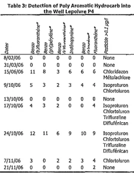
Ta support the hypothesis of surface water Infiltration, molecule usually present in surface water, as Poly Aromatic Hydrocarb (PAH) has been studied (table 3).
The pollution caused by pesticide is closely connected ta the presence ofPAH.This observation Is one other element that proves the surface water Infiltration into the catchment. Now, the origin of the surface water must he find: perched stream infiltration or Infiltration by the sinkhole.
Ta get a c1ear answer, river gauging and tracer tests shoud be performed to answer.
In the case of the origln of thls pollution is the stream infiltration, lt's important ta point out that the LE's farm is located closed to the stream upstream the catch ment. The rinslng of the sprayer into the farmyard couldhethe cause of pollution.
Table 3: Detection of PolV Aromatic Hydrocarb Inta the Weil Lepoivre P4
~
,
•
~l
,
•
~
~ <l i;~l
•
.\),
~
~
.!
i; ~ ~o!
0 ~~
J'
N..:; 'cS"
~~
§
d~
~"
,,~ ~~'"
8/02/06 0 0 0 0 0 0 None 31/03/06 0 0 0 0 0 0 None 15/06/06 11 8 3 6 6 6 Chlorldazon Métolachlore 9/10/06 5 3 2 3 4 4 Isoproturon chtortoturon 13/10/06 0 0 0 0 0 0 None 17/10/06 4 3 2 0 0 4 Isoproturon Chlortoluron Trlfiurallne DifTufénlcan 24/10/06 12 11 6 9 10 9 Isoproturon Chlortoluron Trifluratine Diflufénlcan 7/11/06 3 0 2 2 3 4 Chfortoluron 21/11/06 0 0 0 0 0 2 None*
PAH express as ng/tCorrective measures will be analysed for surface water Infiltration but at first the hypothesis must be proved, This point is not developed Into thls paper. If these hypothesis are confirmed, the river f100r and banks will have to he leak proofed. In any case, surface water infiltration by sinkhole has to be stopped, as abnormal turbidity has been found in sorne wells during heavy ralny events.
ACKNOWLEDGEMENT
We want to thank the drinking water producer, SWDE to his efficient collaboration for this study.
REFERENCES
Arvalis. 2003. Theoretical basls for diagnosing non-pant source pollution by pesticides. Footprint project. 16p.
Bourguignon p.1959.Texte explicatif de la planchette demettet-16se. Carte des sols de la belgique. Irsia, bruxelles,B3p.
Buffet d, oger r, delongueville v, tychon b. 2005. Workshop on climatic analysls and mapping for agriculture bofogna, italy. 14-17 june 2005. Meeting report sept.2005,
Eew. 2007. Rapport analytique sur l'état de l'environnement wallon. \'>1inistère de la région wallonne. Dgrne.
Iupac.1995.Offslte transport of pesticides ln water : mathematical models of pesticide leachlng and runoff (technlcal report). Pure and appl. Chem. Vol67,12. 2109-214Bpp.

![[PDF] Formation PowerPoint 2010 enjeux et pratique | Cours informatique](data:image/gif;base64,R0lGODlhAQABAIAAAP///wAAACH5BAEAAAAALAAAAAABAAEAAAICRAEAOw==)