Submitted to the 1
stInternational Conference on Energy, Environment And Climate Changes
Trends in extreme rainfall events in Benin (West Africa), 1960-2000
Yvon-Carmen HOUNTONDJI
Faculty of Agronomy, University of Parakou BP 123, Parakou, Benin
e-mail: [email protected] Florence DE LONGUEVILLE
Department of Geography, FUNDP-University of Namur Rue de Bruxelles 61, 5000 Namur, Belgium
e-mail: [email protected] Pierre OZER
Department of Environmental Sciences and Management, University of Liège Avenue de Longwy 185, B-6700 Arlon, Belgium
e-mail: [email protected]
Abstract—Global dataset of derived indicators has been compiled to clarify whether the frequency and / or the severity of rainfall extremes changed during the 1960 – 2000 period in the Republic of Benin in West Africa. This period provides the best spatial coverage of homogenous daily series, which can be used for calculating the proportion of global land area exhibiting a significant change in extreme or severe rainfall. We selected 12 indicators of extreme climatic events that are based on daily totals of precipitation. The six first indicators are the annual total precipitation (RTOT); the annual total of wet days (with daily rainfall >= 1mm, Rd); the simple day intensity index (SDII) calculated as the average rainfall from wet days; the annual maximum rainfall recorded during 1, 5, and 30 days (Rx1d, Rx5d, and Rx30d). The other six indices are based on the 95th and 99th percentiles calculated from the daily rainfall data over the 1961-1990 period, that is the 30-year period required by the World Meteorological Organization (WMO) for the calculation of normals. The 95th percentile defines a very wet day. The 99th percentile corresponds to an extreme rainfall event. Based on these percentiles, three extreme precipitation indices were chosen. Very wet day and extreme rainfall frequency are based on the annual count of days with rainfall >= 95th and 99th percentiles of 1961-1990 (R95p and R99p). Very wet day and extreme rainfall intensity corresponds to the annual total precipitation recorded from days with rainfall >= 95th and 99th percentiles of 1961-1990 (R95pSUM and R99pSUM). Very wet day and extreme rainfall proportion is the percentage of the annual total precipitation recorded from days with rainfall >= 95th and 99th percentiles of 1961-1990 (R95pTOT and R99pTOT) and measures how much of the total rain comes from very wet or extreme events. Only time series which had complete records from 1960 to 2000 were used. A total of 21 stations time series were extracted from national climate archives and collated into the unique dataset described here. National maps showing trends during the 1960-2000 period were produced. Results show that only the annual total precipitation, the annual total of wet days and the annual maximum rainfall recorded during 30 days present a significant decreasing trend while the other nine rainfall indicators appear to remain stable. These results are important findings for Benin since scarce works realized in neighbouring regions of West Africa describe a situation more prone to increases in extreme rainfall (in Nigeria) or the opposite (in Guinea Conakry and in Niger) in a similar context of a clear reduction in the yearly precipitation
amount. We call for further research on this topic in West Africa since water management is a major tool for sustainable development and poverty alleviation.
Keywords: Rainfall, precipitation indices, drought, Benin, West Africa
I. INTRODUCTION
Extreme weather and climate events have received increased attention in the last few years. Extreme events can be defined by the impact one event has on society. This impact may involve excessive loss of life, excessive economic or monetary losses, or both. Since population and infrastructure continues to increase in, sometimes, areas that are vulnerable to extremes such as flooding, storm damage, and extreme heat waves, it is not that clear whether such impacts are due to increasing frequency of extreme events or to growing vulnerability. Yet, several landscape use and societal infrastructure changes can often further increase vulnerability by, for example, creating more potential for catastrophic impacts from climate extremes. Although there are different ways to define extreme climate events, the latest Intergovernmental Panel on Climate Change (IPCC) report predicts, by the mid- to late 21st century, a very likely (that is a probability of occurrence of over 90%) increase in warm spells, heat waves and heavy precipitation, and a likely (that is a probability of occurrence of over 66%) increase in intense tropical cyclone activity and in areas affected by droughts [1]. Without taking into account any changes or developments in adaptive capacity, the major projected impacts of a very likely increase in heavy precipitation are:
• Agriculture, forestry and ecosystems: damage to crops; soil erosion, inability to cultivate land due to waterlogging of soils;
• Water resources: adverse effects on quality of surface and groundwater; contamination of water supply; water scarcity may be relieved;
• Human health: increased risk of deaths, injuries and infectious, respiratory and skin diseases;
• Industry, settlement and society: disruption of settlements, commerce, transport and societies due to flooding: pressures on urban and rural infrastructures; loss of property [1].
In recent decades, studies found out that increases in extreme rainfall events are apparent in some areas of the world, while in others there appears to be a decline [2]. While some regions of the world are well covered by such studies, there is a paucity of information on trends in daily extreme rainfall events regarding the African continent, especially in West Africa [3]. The lack of long-term climate data suitable for analysis of extremes is the biggest obstacle to quantifying whether extreme events have changed over the last decades, either continental or on a more regional basis [4]. This gap is linked to the lack of easily available daily data for the region. The present study has been conducted in the intent to fill a bit in this gap, by a case study in this region focused on Benin. In this paper, evidence for changes in the intensity of extreme daily rainfall events over Benin during the last decades of the twentieth is assessed. Our database is briefly described; then, results of the tendency analysis of extreme climate indices based on daily precipitation are discussed.
II. DATA AND METHODS A. Data
In order to evaluate recent trends in extremes rainfall, data were made available for Benin from “Agence pour la Sécurité de la Navigation Aérienne en Afrique et à Madagascar (ASECNA)” of Cotonou. The database includes meteorological stations throughout the country. Originally, data series from 74 meteorological stations from ASECNA have been tested for including to our database. Based on the station history, and on the ratio of missing data, the number of stations had to be reduced to 21 according to the following general criteria [5]: [i] from the entire 1960–2000 period, data must be available for at least 40 years, [ii] missing data cannot be more than 10%, [iii] missing data from each year cannot exceed 20%, and [iv] more than 3 months consecutive missing values are not allowed.
Yet, the stations were selected on the basis of completeness of records and were chosen only if the complete daily records were available during the 1960-2000 period. Stations that involved site relocations were not included. The selected stations were gathered into three bioclimatic zones described hereafter [6]:
• The Sudanian zone, located between 9°45’ and 12°25’N: the mean annual rainfall is often less than 1000 mm and the relative humidity varies from 18– 99%. The temperature varies from 24 to 31°C. The vegetation of this zone is mainly composed of savannas with trees of small size (7 stations selected).
• The Sudan-Guinean zone, located between 7°30’ and 9°45’N: the rainfall zone is unimodal, from May to October, and lasts for about 113 days with an annual total rainfall varying between 900–1110 mm. The annual temperature ranges from 25 to 29°C, and
the relative humidity from 31 to 98 %. The vegetation of the Sudan- Guinean transition zone is characterized by a mosaic of woodland, dry dense forests, tree and shrub savannas and gallery forests (4 stations selected).
• The sub-humid Guinean zone, located between 6°25’ and 7°30’N: in this zone the rainfall is bimodal with a mean annual rainfall of 1200 mm. The mean annual temperature varies between 25° and 29°C and the relative humidity between 69 and 97 %. The primal vegetation consists of dense semi-deciduous forests and Guinean savannas (10 stations selected). The characteristics of the selected stations are presented in Table I and their spatial location according the bioclimatic zones is shown on Fig. 1.
TABLE I. STATIONS INCLUDED IN THE STUDY
Bioclimatic zones
Station ID
Station Name Lat. (N) Long. (E) Elev. (m) 1 Grand Popo 6.283 1.817 5 2 Cotonou 6.350 2.383 4 3 Ouidah 6.367 2.083 10 4 Porto Novo 6.483 2.617 20 5 Adjohoun 6.700 2.483 60 6 Sakete 6.717 2.667 69 7 Aplahoue 6.917 1.667 153 8 Lonkly 7.150 1.690 110 9 Bohicon 7.167 2.067 166 Sub –humid Guin ean 10 Zangnanado 7.250 2.333 102 11 Dassa Zoume 7.750 2.167 155 12 Save 7.983 2.433 199 13 Parakou 9.350 2.600 392 Sudan- Guinea n 14 Okpara 9.467 2.733 295 15 Bembereke 10.200 2.667 491 16 Kalale 10.300 3.383 410 17 Natitingou 10.317 1.383 460 18 Tanguieta 10.617 1.267 225 19 Kandi 11.133 2.933 290 20 Banikoara 11.300 2.433 310 Sudanian 21 Malanville 11.867 3.400 160 B. Extreme rainfall indices
In this study, 12 extreme rainfall indices were calculated over the January to December period and are listed in Table II [*]. In addition to classic indices such as the annual total precipitation (RTOT) and the annual total of wet days (with daily rainfall >= 1mm, Rd), the simple day intensity index (SDII) was calculated as the average rainfall from wet days. Three indices consider annual maximum rainfall recorded during 1, 5, and 30 days (Rx1d, Rx5d, and Rx30d). Other six indices are based on the 95th and 99th percentiles. Such analysis method is commonly used now and is likely to be the most adequate when a study covers a broad region [7-9].
These percentile values are calculated from the daily rainfall data over the 1961-1990 period. The 95th percentile,
defined as a very wet day, corresponds to the 547th highest value recorded over the 30-year reference period. The 99th percentile corresponds to the 110th highest value of the 1961-1990 period and is qualified as an extreme rainfall event. In average, the thresholds (for all the studied stations) calculated from percentiles are 49.7 mm and 79.6 mm to define a very wet day and an extreme rainfall event, respectively [*]. Based on percentiles, three extreme precipitation indices were chosen. Very wet day and extreme rainfall frequency are based on the annual count of days with rainfall >= 95th and 99th percentiles of 1961-1990 (R95p and R99p). Very wet day and extreme rainfall intensity corresponds to the annual total precipitation recorded from days with rainfall >= 95th and 99th percentiles of 1961-1990 (R95pSUM and R99pSUM) and gives an indication on the rain received from very wet or extreme rainfall. Very wet day and extreme rainfall proportion is the percentage of the annual total precipitation recorded from days with rainfall >= 95th and 99th percentiles of 1961-1990 (R95pTOT and R99pTOT) and measures how much of the total rain comes from very wet or extreme events.
C. Trend analisys
Hereafter, trend coefficient and tendency are used as equivalent terms. Extreme events (e.g., local floods) often occur on local scale, but on the other hand, they are all important part of large scale climate patterns. However, local extremes could disappear in case of a spatial data interpolation. Therefore, maps presented in this paper use station data instead of gridded database. In the analysis, trend coefficients are determined (using linear regression modelling), which represent the increasing or decreasing rate of the given index during the 1960-2000 period. The regression slopes were recorded for each station as parameters characterising the global trends for the rainfall indices. Moreover, each slope (positive or negative) was mapped in six classes indicating significant, moderate or non-significant trends. The regression procedure supplies a
Student-t test and its resulting significance p-level to analyse the hypothesis that the slope is equal to 0. This p-level was used as a criterion to define the class boundaries. The trends, for each index, were labelled as "significant" if the p-level exceeds 0.05 for the one-tailed t-test, "moderate" if the p-level ranges between 0.05 and 0.1 and otherwise “non significant” if the p-level is up to 0.1.
Figure 1. Geographical distribution of meteorological stations in Benin. TABLE II. RAINFALL INDICES WITH THEIR DEFINITIONS AND UNITS (ALL INDICES ARE CALCULATED ANNUALLY FROM 1JANUARY TO 31DECEMBER).
ID INDICATORNAME DEFINITION UNIT
RTOT Precipitation total Annual total precipitation [mm]
Rd Rainfall days Annual total of wet days (A wet day has rainfall >= 1mm) [days] SDII Simple day intensity index Average rainfall from wet days [mm/day]
Rx1d Maximum 1-day rainfall Annual maximum 1-day rainfall [mm]
Rx5d Maximum 5-day rainfall Annual maximum 5-day rainfall [mm]
Rx30d Maximum 30-day rainfall Annual maximum 30-day rainfall [mm] R95p Very wet day frequency Annual count of days with rainfall >= 95th percentile of 1961-1990 [days] R99p Extreme rainfall frequency Annual count of days with rainfall >= 99th percentile of 1961-1990 [days] R95pSUM Very wet day intensity Annual precipitation from days with rainfall >= 95th percentile of 1961-1990 [mm] R99pSUM Extreme rainfall intensity Annual precipitation from days with rainfall >= 99th percentile of 1961-1990 [mm] R95pTOT Very wet day proportion Percentage of annual total rainfall from days with rainfall >= 95th percentile of 1961-1990 [%] R99pTOT Extreme rainfall proportion Percentage of annual total rainfall from days with rainfall >= 99th percentile of 1961-1990 [%]
III. RESULTS
All precipitation-based maps show a mixed pattern of positive and negative changes. Overall, most precipitation indices exhibit a statistically nonsignificant trend throughout Benin. Thus, a small fraction of stations exhibited statistically significant increasing or declining trends, but any consistency was highlighted through the spatial pattern of the selected indices (Table III).
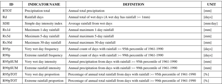
A. Precipitation total, rainfall days and simple day intensity index
RTOT indicates a global pattern of yearly rainfall decline all over the country during the 1960-2000 period (Fig. 2a) since 95.3% of the stations present a decreasing trend. A significant decline is observed in 14.3% of the stations while
no moderate or significant increasing trend is observed. Although the global mean decline of yearly rainfall is -3.7% per decade, a slight difference is highlighted when considering the three ecological zones of the country. Yet, a gradual decline of RTOT appears from North to South, with a mean trend of -2.5%, -3.3% and -4.7% per decade (respectively for the Sudanian, Sudan-Guinean and sub-humid Guinean zones). A similar spatial pattern is observed for Rd with an average decrease of -3% per decade during the same period. The decreasing trend is significant for 28.6% of the stations while no moderate or significant increasing trend is observed (Fig. 2b).
For what regards SDII, 85.5% of the stations present no significant trends. Other stations show moderate or significant declining trend (Fig. 2c).
TABLE III. RELATIVE PROPORTION OF THE EXTREMES RAINFALL INDICES TRENDS IN BENIN (1960-2000)
Trend significance* INDICES SD % MD % NSD % NSI % MI % SI % RTOT 3 14.3 3 14.3 14 66.7 1 4.8 - - - - Rd 6 28.6 2 9.5 11 52.4 2 9.5 - - - - SDII 2 9.5 1 4.8 7 33.3 11 52.4 - - - - R95p 1 4.8 2 9.5 11 52.4 7 33.3 - - - - R95pSUM 1 4.8 1 4.8 12 57.1 7 33.3 - - - - R95pTOT - - 1 4.8 10 47.6 9 42.9 - - 1 4.8 R99p 1 4.8 1 4.8 9 42.9 8 38.1 - - 2 9.5 R99pSUM 1 4.8 1 4.8 10 47.6 6 28.6 1 4.8 2 9.5 R99pTOT 1 4.8 - - 9 42.9 8 38.1 1 4.8 2 9.5 Rx1d 1 4.8 - - 13 61.9 5 23.8 - - 2 9.5 Rx5d 2 9.5 2 9.5 12 57.1 5 23.8 - - - - Rx30d 6 28.6 - - 12 57.1 3 14.3 - - - -
* SD: significant decrease; MD: moderate decrease; NSD: non significant decrease; NSI: non significant increase; MI: moderate increase; SI: significant increase
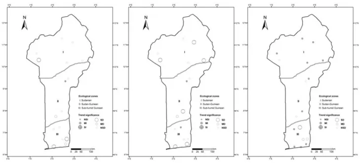
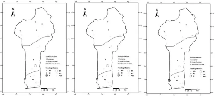
B. Very wet and extreme day frequency, intensity and proportion
A very wet day corresponds to days with rainfall >= 95th percentile of 1961-1990. Trends in R95p, R95pSUM and R95pTOT (Fig. 3) are rarely significant although about two-third of the stations present decreasing tendencies in a fuzzy and unclear geographical distribution. A similar geographical pattern is obtained from the analysis of trends in extreme rainfall (R99p, R99pSUM and R99pTOT) although 9.5% of the stations present a significant increase of these indices (Fig. 4). Even though this remains anecdotic, it is worth to mention it since extreme rainfall indices are the only ones presenting more significant increases than those indicating a decrease.
C. Maximum 1-, 5- and 30-day rainfall
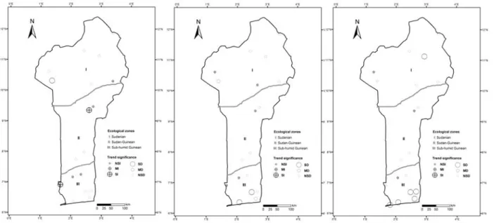
The maximum 1- and 5-day rainfalls were of 73 mm and 122 mm in average during the 1960-2000 periods [*]. These two indices (Rx1d and Rx5d, Fig. 5a-b) do not present pronounce trends for a majority of stations. A significant increase is observed in 9.5% of the stations for Rx1d while other 9.5% stations show a significant decline for Rx5d.
The maximum 30-day rainfall was 328 mm in average during the 1960-2000 period [*]. The trend of this index (Rx30d, Fig. 5c) is different from the two preceding indices. Yet, 85.7% of the stations present a decreasing trend of the Rx30d index and a significant decreasing trend is calculated in a majority of stations (5 out of 6) located in the coastal area of the sub-humid Guinean zone.
Figure 3. Same as Fig. 2 for trends in R95p (left), R95pSUM (centre) and R95pTOT (right) in Benin for the period 1960–2000.
Figure 5. Same as Fig. 2 for trends in Rx1d (left), Rx5d (centre) and Rx30d (right) in Benin for the period 1960–2000. IV. DISCUSSION AND CONCLUSION
As mentioned previously, lack of long-term climate data suitable for analysis of extremes is the biggest obstacle to quantifying whether extreme events have changed over the last decades in Africa. In Benin, we face the same difficulty since only 21 stations out of 74 of the complete meteorological network can be used since 1960. From the calculation of twelve different indices of precipitation and extreme precipitation events, it appears that total precipitation, annual count of wet days and annual maximum 30-day total rainfall were the indices most affected by a decrease over the 1960-2000 period since over 85% of the stations showed a decline. On the opposite, only the extreme precipitation indices present a relative stability with half of the stations presenting an increase in extreme rainfall. These findings are in accordance with the fourth the latest IPCC report which states that precipitation extremes are projected to increase more than the average rainfall are projected to increase [1]. However, because of the scarcity of similar studies in West Africa, it is difficult to confirm or to discuss our results on a regional basis. Still, these are important findings for Benin since scarce works realized in neighbouring countries describe a situation more prone to increases in extreme rainfall in Nigeria [3] or Western Niger [10] or the opposite in Nigeria [2], Guinea Conakry [11] or in Eastern Niger [12] in a similar context of a clear reduction in the yearly precipitation amount.
Given the weak global policy response to climate change and the increasing vulnerability in developing countries, we have to prepare for an uncertain climate future [13-14]. Yet, recent devastating floods in Benin showed the total unpreparedness of local and national authorities in risk and catastrophe management [15]. We therefore call for further research on this topic in West Africa since water management is a major tool for sustainable development and poverty alleviation.
REFERENCES
[1] Core Writing Team, R. K. Pachauri, and A. Reisinger, Climate Change 2007: Synthesis Report. Contribution of Working Groups I, II and III to the Fourth Assessment Report of the Intergovernmental Panel on Climate Change. IPCC, Geneva, Switzerland, 2007.
[2] D. R. Easterling, J. L. Evans, P. Ya. Groisman, T. R. Karl, K. E. Kunkel, et al., “Observed variability and trends in extreme climate events: a brief review,” Bull. Am. Meteorol. Soc., vol. 81, pp. 417-425, 2000.
[3] M. New, B. Hewitson, D. B. Stephenson, A. Tsiga, A. Kruger, et al., “Evidence of trends in daily climate extremes over southern and West Africa,” J. Geophys. Res., vol. 111, 2006, D14102, doi:10.1029/2005JD006289.
[4] D. R. Easterling, H. F. Diaz, A. V. Douglas, W. D. Hogg, K. E. Kunkel, et al., “Long-term observations for monitoring extremes in the Americas,” Climatic Change, vol. 42, pp. 285-308, 1999.
[5] A. M. G. Klein Tank, J. B. Wijngaard, and A. van Engelen, Climate of Europe; Assessment of observed daily temperature and precipitation extremes. KNMI, De Bilt, Netherlands, 2002.
[6] Y.C. Hountondji, “Dynamique environnementale en zones sahélienne et soudanienne de l’Afrique de l’Ouest : Analyse de l’évolution et évaluation de la dégradation du couvert végétal,” Thèse de Doctorat en Sciences, Université de Liège, Arlon, Belgium, 2008. http://bictel.ulg.ac.be/ETD-db/collection/available/ULgetd-09102008-111402/
[7] M. J. Manton, P. M. Della-Marta, M. R. Haylock, K. J. Hennessy, N. Nicholls, et al., “Trends in extreme daily rainfall and temperature in Southeast Asia and the South Pacific: 1961-1998,” Int. J. Climatol., vol. 21, pp. 269-284, 2001.
[8] G. M. Griffiths, M. J. Salinger, and I. Leleu, “Trends in extreme daily rainfall across the South Pacific and relationship to the South Pacific Convergence Zone,” Int. J. Climatol., vol. 23, pp. 847-869, 2003.
[9] M. R. Haylock, T. Peterson, J. R. Abreu de Sousa, L. M. Alves, T. Ambrizzi, et al., “Trends in total and extreme South American rainfall in 1960-2000 and links with sea surface temperature,” J. Climate, vol. 19, pp. 1490-1512, 2006. [10] A. Ozer and P. Ozer, ‘Désertification au Sahel : Crise
climatique ou anthropique?,’ Bulletin des Séances de l’Académie royale des Sciences d’Outre-Mer, vol. 51, pp. 395-423, 2005. http://hdl.handle.net/2268/16053
[11] E. Aguilar, A. Aziz Barry, M. Brunet, L. Ekang, A. Fernandes, et al., “Changes in temperature and precipitation extremes in western central Africa, Guinea Conakry, and Zimbabwe, 1955–2006,” J. Geophys. Res., vol. 114, 2009, D02115, doi: 10.1029/2008JD011010.
[12] P. Ozer, Y.C. Hountondji, and O. Laminou Manzo, “Evolution des caractéristiques pluviométriques dans l’est du Niger de 1940 à 2007,” GEO-ECO-TROP, Vol. 33, pp. 11-30, 2009. http://hdl.handle.net/2268/78267
[13] M. De Dapper, D. Swinne, and P. Ozer, Developing countries facing global warming: a post-Kyoto assessment. Académie
royale des Sciences d’Outre-Mer, Brussels, Belgium, 2010.
http://hdl.handle.net/2268/96015
[14] P. Ozer, “Social and environmental impacts of climate change: In the absence of mitigation, will we be able to adapt?,” paper presented at the 1st International Conference on Energy, Environment and Climate Changes, Ho Chi Minh City, Vietnam, 27th and 28th August, 2011.
http://hdl.handle.net/2268/96763
[15] P. Ozer, A. Afouda, Y.C. Hountondji, E. Ahlonsou, A. Houanye, et al., “Effets du réchauffement global sur les variables climatiques et hydrologiques au Bénin: Analyse de l’année 2010 par rapport aux données historiques,” 2010.
http://hdl.handle.net/2268/80202
[*] Location, elevation and rainfall characteristics averaged over the 1960-2000 period for the 21 stations, as well as Fig. 2-5 in larger format are available from: