HAL Id: hal-01241161
https://hal.univ-reunion.fr/hal-01241161
Submitted on 7 Jun 2017
HAL is a multi-disciplinary open access
archive for the deposit and dissemination of
sci-entific research documents, whether they are
pub-lished or not. The documents may come from
teaching and research institutions in France or
abroad, or from public or private research centers.
L’archive ouverte pluridisciplinaire HAL, est
destinée au dépôt et à la diffusion de documents
scientifiques de niveau recherche, publiés ou non,
émanant des établissements d’enseignement et de
recherche français ou étrangers, des laboratoires
publics ou privés.
Characteristics of the summit lakes of Ambae volcano
and their potential for generating lahars
Philipson Bani, Jean-Lambert Join, S. J. Cronin, Michel Lardy, Isabelle
Rouet, E. Garaebiti
To cite this version:
Philipson Bani, Jean-Lambert Join, S. J. Cronin, Michel Lardy, Isabelle Rouet, et al.. Characteristics
of the summit lakes of Ambae volcano and their potential for generating lahars. Natural Hazards and
Earth System Sciences, European Geosciences Union, 2009, 9 (4), pp.1471-1478.
�10.5194/nhess-9-1471-2009�. �hal-01241161�
Characteristics of the summit lakes of Ambae volcano and their
potential for generating lahars
P. Bani1,2, J.-L. Join1, S. J. Cronin3, M. Lardy1, I. Rouet1,2, and E. Garaebiti4
1Institut de Recherche pour le D´eveloppement, BP A5 98848, Noum´ea Cedex, New Caledonia
2Pˆole Pluridisciplinaire de la Mati`ere et de l’Environnement, Universit´e de la Nouvelle Cal´edonie, BP R4, Noum´ea,
New Caledonia
3Volcanic Risk Solutions, Institute of Natural Resources, Massey University, Private Bag 11 222, Palmerston North,
New Zealand
4Geohazards, Department of Geology Mines and Water Resources, Port Vila, Vanuatu
Received: 24 February 2009 – Revised: 9 August 2009 – Accepted: 14 August 2009 – Published: 25 August 2009
Abstract. Volcanic eruptions through crater lakes often
gen-erate lahars, causing loss of life and property. On Ambae vol-cano, recent eruptive activities have rather tended to reduce the water volume in the crater lake (Lake Voui), in turn, re-ducing the chances for outburst floods. Lake Voui occupies a central position in the summit caldera and is well enclosed by the caldera relief. Eruptions with significantly higher magni-tude than that of 1995 and 2005 are required for an outburst. A more probable scenario for lahar events is the overflow from Lake Manaro Lakua bounded on the eastern side by the caldera wall. Morphology and bathymetry analysis have been used to identify the weakest point of the caldera rim from which water from Lake Manaro Lakua may overflow to initiate lahars. The 1916 disaster described on south-east Ambae was possibly triggered by such an outburst from Lake Manaro Lakua. Taking into account the current level of Lake Manaro Lakua well below a critical overflow point, and the apparently low potential of Lake Voui eruptions to trigger la-hars, the Ambae summit lakes may not be directly responsi-ble for numerous lahar deposits identified around the Island.
1 Introduction
Ambae Island (also known as Aoba) is the emerged part of the most voluminous volcano of the Vanuatu archipelago (Fig. 1), with 3900 m height from the seabed and a volume of 2500 km3. A pronounced NE-SW trending rift zone dot-ted with scoria cones gives the 16×38 km island an elongadot-ted form. A broad pyroclastic cone containing three lakes is
lo-Correspondence to: P. Bani
(philipson.bani@noumea.ird.nc)
cated at the summit of this shield volcano within the youngest of at least two nested calderas formed less than 2000 years ago (Warden, 1970). Lake Voui is one of the largest acid crater lakes worldwide (2.04 km2)located 1400 m above sea level. Since the phreatic eruption in 1995 (e.g., Robin et al., 1995), after more than 300 years being dormant, Am-bae volcano receives increasing attention – many authors have pointed out that Ambae is the most dangerous volcano in Vanuatu (Cronin et al., 2004; Monzier et Robin, 1995; Garaebiti, 2000; Bani et al., 2004). Robin and Monzier (1995) have pointed out that numerous and thick lahar de-posits, probably not older than 100–320 years, occurred on both coasts in the central part of Ambae. The recent Surt-seyan eruption (Lardy et al., 2005; Garaebiti et al., 2005; Nemeth et al., 2006) – beginning on the 27 November 2005, lasted almost two months. It was a minor event on a world scale, but one of the larger eruptions of the volcano in its short-record of volcanic activity. The eruption built up a tephra/tuff cone within the Lake Voui, which progressively isolated the active vent from the water, enabling the volcanic gas emissions directly into the atmosphere. SO2flux
mea-surements results indicate high emissions during and follow-ing the eruption period with significant impact on vegetation. The scale of explosions during this event never reached the point where water was laterally ejected from the Lake Voui and no lahar was generated. This eruption has focussed at-tention on the island lahar hazard assessment, which has not taken full cognisance of the characteristics of the summit lakes and of potential lahar origins. New contributions of this work are the bathymetry of crater lakes, summit morphology, lake water volumes their potential for generating lahars.
1472 P. Bani et al.: Ambae summit lakes and their potential for lahars
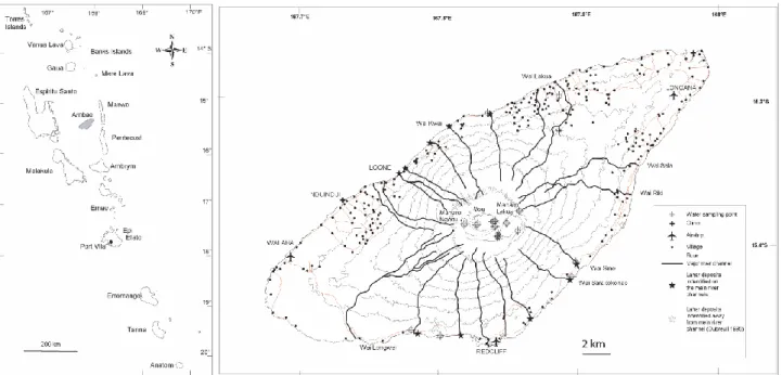
Fig. 1. Left panel, Vanuatu archipelago with Ambae Island in grey. Right panel, Ambae Island showing major river catchments, villages and roads. The summit lakes are labelled. Notice that a water outburst from the eastern part of Manaro Lakua is a threat to villages between Wai Sine and Wai Riki. Note the positions of the water sampling sites at the summit and on the coast.
2 Methods
We used a 40 m digital elevation model (DEM), obtained from 1/50 000 topographic map, to determine the summit morphology, the structural lineaments and delineate the ma-jor flow paths on Ambae Island. Field surveys were carried out to identify lahar-prone flow channels and lahar deposits. SPOT satellite data were use to complement to field survey. We refer to the term lahars as a group of volcanic debris flow (fairly uniform mixtures of water and >50% by volume of solids – e.g., Vallance, 2000). To evaluate the potential of the Ambae summit lakes for generating past lahars, we car-ried out field surveys on lake Voui and lake Manaro Lakua. Hydrographical data were obtained using an inflatable boat with depth sounders and GPS positioning device. Waters from lakes and tributaries, as well as from springs and creeks around the massif volcano were sampled and analysed us-ing ICP-OES for cations and Technicon Auto-Analyzer for SO4and Cl. We refer to the Piper diagram to distinguish
sur-face water from ground water – mineralised crater lake water are also well discriminated with this diagram (e.g., Cruz and Franc¸a, 2006). We use the Shoeller diagram to determine the importance of chemistry changes in water in relation to the volcanic activities. SO2 flux measurements were
car-ried out using miniaturised Differential Optical Absorption Spectroscopy (Platt, 1994) carried alternatively on board a CESSNA 206G and a Britten-Norman Islander.
3 Results
3.1 Lakes Bathymetry and water volume
Bathymetry results obtained in this work (Fig. 2) indicate a generally shallower lake Manaro Lakua contrasting with the deep lake Voui. Two depth points of around 20 m were iden-tified in Manaro Lakua, close to the eastern margin. Its cal-culated water volume is 17×106m3 with a surface area of 2.08 km2. Lake Voui has a similar surface area (2.04 km2) but a volume of 40×106m3of water. The deepest point in Voui was identified as c. 120 m, located in the middle of the lake. Regularly, bubbles are sighted above this point (Fig. 3) – and in 2005, this point was the principal site of the eruptive activity. Manaro Ngoru, to the west of Voui is a periodically dry shallow lake that may contain up to 0.05×10⁶m3of wa-ter.
The summit of Ambae volcano thus hosts more than 57 million cubic meters of water, 70% of which is acidic and is contained within lake Voui.
3.2 Summit morphology
Figure 4 highlights the locations of the 3 lakes at the sum-mit of Ambae volcano. The distance between Manaro Lakua and Voui is 200 m and there is around 450 m between Voui and Manaro Ngoru. Lake Voui occupies the center of Am-bae summit and is located 2.5 km from the caldera margins. The Lake Voui water surface is located 100 m below the Voui crater rim and close to 200 m from the caldera rim. Manaro
Fig. 2. (A) Bathymetry of crater lake Voui with its deepest point (∼120 m) in the center of the lake. Bathymetry data points were obtained in 1996 (Lardy et al., 1997) and recalculated for this paper. (B) Bathymetry of Manaro Lakua. Note the deepest points (∼20 m) to the east of the lake. Data were obtained in 2005.
Fig. 3. Lake Voui in 2000, with a discoloration on top of the deep-est point identified on bathymetry and suggdeep-esting hydrothermal dis-charge into the lake.
Lakua is perched 10–20 m above lake Voui; its eastern side is bounded by the caldera margin. The Manaro Lakua water level is typically around 100 m below the caldera rim, except in its eastern portion where this drops to only 60 m (Fig. 5). The lowest bounding rim occurs over around 400 m of the lake margin, potentially being the most likely location for water outbursts from the summit area. The periodically dry Manaro Ngoru is more than 700 m from the caldera rim and is protected by more than 100 m relief to the west.
Caldera limits on Ambae are relatively well character-ized; isolating the main streams within the caldera from the drainage outside it. The closest distinctive channels from the summit lakes begin 500 m to the east and southeast (Fig. 1) of the lakes.
3.3 Water chemistry
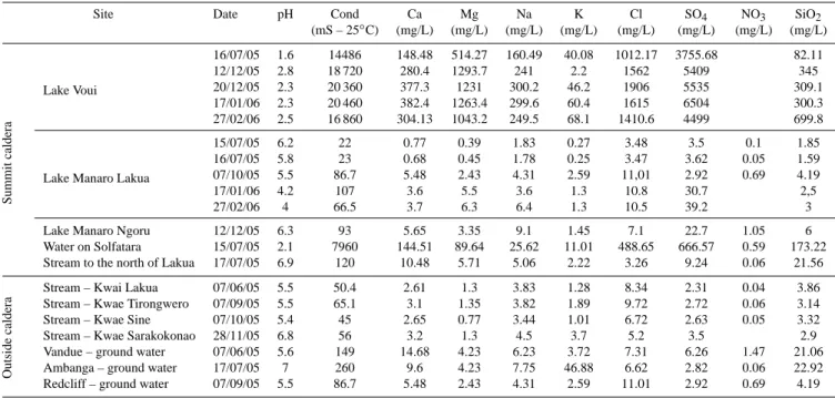
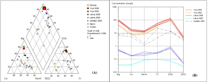
A total of 27 water samples were collected on Ambae (Fig. 1) and analysed in this work. Results are summarised in Ta-ble 1. The Piper diagram (Fig. 6a) indicates differences in water chemistry between summit lakes, springs and creeks of Ambae. Water from springs (ground water) can be dis-tinguished by their relatively high content in SiO2. Water
from creeks (surface water) are enriched in Cl-Na, while Voui and Manaro Lakua appear enriched with MgSO4due to
the magmatic-hydrothermal mechanisms. Close to the east bank of Manaro Lakua, water sampled over an active solfa-tara, presents similar characteristics as lake Voui.
Between 2005 and 2006, Voui and Manaro Lakua have ex-perienced increases in chemical concentrations (Fig. 6b) in accordance with the end-2005 eruption (e.g., Nemeth et al., 2006). SO2flux results obtained during this period exceed
the 1000 t/d and fluctuated in accordance to the volcanic ac-tivity (Bani et al., 2009).
3.4 Volcaniclastic deposits
Along the coast of Ambae volcano, sixteen out of the main flow channels delineated from the DEM were visited along with 10 sites of volcaniclastic deposits along the coast. These sites range from 5 to 12 km from the summit. Channels slopes are very steep, commonly 20–25%. Deposits iden-tified at the stream mouths are poorly sorted, containing par-ticles that range from clay to boulder-size (Fig. 7). The clast lithologies include coarse blocky dense and vesicular debris apparently derived from pyroclastic cones and basaltic flows in the north and from similar undifferentiated volcanics in the south of the island. Deposits are generally preserved in small areas, (less than 100 m wide), except for those at Wai
1474 P. Bani et al.: Ambae summit lakes and their potential for lahars
Fig. 4. Summit topographic WNW-ESE profile. Note the location of Voui in the centre of the summit caldera and Manaro Lakua close to the caldera margin. Manaro Ngoru water volume is negligible in comparison to the two other summit lakes.
Table 1. Water analysis results showing concentration of Ca, Mg, Na, K, Cl, SO4, NO3and SiO2outside caldera and chemistry changes in summit lakes.
Site Date pH Cond Ca Mg Na K Cl SO4 NO3 SiO2
(mS – 25◦C) (mg/L) (mg/L) (mg/L) (mg/L) (mg/L) (mg/L) (mg/L) (mg/L) Summit caldera Lake Voui 16/07/05 1.6 14486 148.48 514.27 160.49 40.08 1012.17 3755.68 82.11 12/12/05 2.8 18 720 280.4 1293.7 241 2.2 1562 5409 345 20/12/05 2.3 20 360 377.3 1231 300.2 46.2 1906 5535 309.1 17/01/06 2.3 20 460 382.4 1263.4 299.6 60.4 1615 6504 300.3 27/02/06 2.5 16 860 304.13 1043.2 249.5 68.1 1410.6 4499 699.8
Lake Manaro Lakua
15/07/05 6.2 22 0.77 0.39 1.83 0.27 3.48 3.5 0.1 1.85 16/07/05 5.8 23 0.68 0.45 1.78 0.25 3.47 3.62 0.05 1.59 07/10/05 5.5 86.7 5.48 2.43 4.31 2.59 11,01 2.92 0.69 4.19 17/01/06 4.2 107 3.6 5.5 3.6 1.3 10.8 30.7 2,5 27/02/06 4 66.5 3.7 6.3 6.4 1.3 10.5 39.2 3 Lake Manaro Ngoru 12/12/05 6.3 93 5.65 3.35 9.1 1.45 7.1 22.7 1.05 6 Water on Solfatara 15/07/05 2.1 7960 144.51 89.64 25.62 11.01 488.65 666.57 0.59 173.22 Stream to the north of Lakua 17/07/05 6.9 120 10.48 5.71 5.06 2.22 3.26 9.24 0.06 21.56
Outside
caldera
Stream – Kwai Lakua 07/06/05 5.5 50.4 2.61 1.3 3.83 1.28 8.34 2.31 0.04 3.86 Stream – Kwae Tirongwero 07/09/05 5.5 65.1 3.1 1.35 3.82 1.89 9.72 2.72 0.06 3.14 Stream – Kwae Sine 07/10/05 5.4 45 2.65 0.77 3.44 1.01 6.72 2.63 0.05 3.32 Stream – Kwae Sarakokonao 28/11/05 6.8 56 3.2 1.3 4.5 3.7 5.2 3.5 2.9 Vandue – ground water 07/06/05 5.6 149 14.68 4.23 6.23 3.72 7.31 6.26 1.47 21.06 Ambanga – ground water 17/07/05 7 260 9.6 4.23 7.75 46.88 6.62 2.82 0.06 22.92 Redcliff – ground water 07/09/05 5.5 86.7 5.48 2.43 4.31 2.59 11.01 2.92 0.69 4.19
Kwai and Wai Sine (Fig. 1) where they extent to a few hun-dred meters wide and are more than 10 m thick. Tree moulds are abundant within the deposits. Volcanoclastic deposits are reported also occur elsewhere on the island flanks (Dubreuil, 1995).
4 Discussion
4.1 Potential caldera outburst point
Base on summit morphology (Fig. 5) and bathymetry (Fig. 2), Manaro Lakua is a dammed-lake, formed after the emplacement of Voui cone. It also bounds the caldera wall and is most likely to generate potential over flow, in contrast to the central positions of Voui and Manaro Ngoru. The east-ern lake shore abuts the lowest point of the caldera rim and the water level is 60 m below it. The edge of the lake is less than 100 m from the caldera margin (Fig. 5), which is formed
pyroclastic deposits (tuff) on top of basaltic lava flows. The two deepest points in Manaro Lakua are also located close to the eastern edge (Fig. 2) contentrating up to 1/3 of the 17 million tons of water and thus pressurising this portion of the caldera wall. Lake Manaro Lakua and lake Voui have no out-lets and the evident controls on the water balance are rain-fall, evaporation and eruption. According to Spiers (2005) the hydrographical balance estimated for both Manaro Lakua and Voui implies an overall surplus of ∼106m3y−1outside volcanic manifestation periods, suggesting a possible sub-surface seepage to maintain equilibrium in lakes under an average annual rainfall of 5000 mm y−1(Wiart et al., 2003). Tree trunks standing in up to 1 m of water, suggest a gradual water level rise in Manaro Lakua, or at least long-term vari-ation in this level over periods of several decades (Fig. 8). With 2.08 km2 of water surface in Manaro Lakua, a mini-mum 125×106m3 of water is necessary to reach the low-est point of the caldera rim and assuming that the surplus
Fig. 5. Morphology of the Ambae summit showing the narrowest and lowest point to the east of Manaro Lakua lake. Note the lowest caldera limit and the reduced volume of the caldera wall to the east of Lakua. DEM generated from existing 1:50 000 topographic map.
calculated for Voui and Manaro Lakua is proportional to the lake surfaces, 2.5 centuries would be necessary to reach the caldera rim. Extraordinary rainfalls during the frequent cy-clones in this area may also have strong influence.
If overflow occurs from Manaro Lakua, it will follow catchments mainly between Wai Riki and Wai Sine to the east and south-east of Ambae Island (Fig. 1). Around 1916, according to De la R¨ue (1945), water from the Ambae sum-mit forced his way through the caldera wall, leading to an avalanche of water that destroyed an entire village on the south-east, killing around one hundred people. The author did not mention any concurrent volcanic activity and referred to the summit as an ancient crater. The direct connection between this event and Manaro Lakua Lakua is extremely difficult to confirm, however the location of the disaster and the absence of volcanic activity supports the potential of a Manaro Lakua overflow. Circumstantially, the time required to fill Manaro Lakua from empty to its critical level, taking into account the hydrographical balance of Spiers (2005) is around 300 years. This is similar to the time lag between the formation of Voui cone in 1575 (Warden, 1970) and the 1916 disaster on south-east Ambae.
4.2 Eruption intensity and lahar events, Lake Voui
With 40×106m3of water, Voui is among the most volumi-nous acid crater lakes worldwide. It is around ten times larger than Ruapehu’s Crater Lake (Christenson and Wood, 1993),
tion of ascending magmatic vapour containing acidic gases (SO2, HCl, HF) produces low-pH solutions (Table 1) that
dis-charge into the lakes (Delmelle and Bernard, 2000). These solutions dissolved silicate rocks and subsequently enriched the lakes with chemical components leached from rocks (Ta-ble 1, Fig. 6). Lake Voui is thus the uppermost manifestation of a hydrothermal reservoir between the surface and an un-derlying magma. Hydrothermal fluids transited through the unique vent highlighted in Fig. 2.
Voui lake with 40 million tons of water above an active volcanic vent, constitutes a serious volcanic hazard to over 30% of the 10 000 inhabitants of Ambae island (Cronin et al., 2004; Monzier et Robin, 1995; Garaebiti, 2000; Bani et al., 2004). An eruption within Voui, water and lake sedi-ments mixed with high-temperature volcanic gases and pyro-clastic materials can be mobilized and jetted onto the slopes at high speed, giving rise to destructive lahars. However re-cent volcanic manifestations, including the phreatic eruption in 1995 (e.g., Robin et al., 1995) and the surseyan eruption in 2005 (Lardy et al., 2005; Garaebiti et al., 2005; Nemeth et al., 2006) were not large enough to trigger any lahar. The lake water level dropped to 7 m in March–April 1995 during the phreatic eruption (Wiart et al., 2003), an equivalent of 14.3×10⁶m3in lost water, corresponding to more than 36% of Voui’s volume. In 2005, the eruption was more intense but occurred during the rainy season (November–March) and in June 2006, 5 months after the eruption, a 6 m drop was indi-cated, indicating a minimum 30% water loss.
Recent volcanic activities on Ambae tend to reduce the water volume, thus reducing the chances for outburst with eruptive activity in the immediately following period. Erup-tions with higher magnitude, such as those that formed the Voui cone in 1575 (Warden, 1970), are probably required to trigger lahars, or those that generate large enough surges to induce volume changes and trigger large seiche-like waves in the neighbouring Manaro Lakua.
4.3 Lake Manaro Ngoru
With only 0.05×10⁶m3of water during rainy season, and its location within a deep portion of the central caldera, Man-aro Ngoru presents minor threat to Ambae population. Water chemistry indicates only minor influences from volcanic dis-charge, suggesting a system relatively isolated from Voui.
4.4 Other potential source for lahar events
Taking into account the relatively long periods required for lake Lakua to reach overflow levels at the caldera rim, the
1476 P. Bani et al.: Ambae summit lakes and their potential for lahars
(A)
(B)
Fig. 6. Piper diagram (A) of water analysis indicates relative abundance of SiO2in underground water. Water from creeks (surface water)
are enriched in Cl-Na , while Voui and Manaro Lakua appear enriched with Mg-SO4due to magmatic-hydrothermal mechanisms. Shoeller
diagram (B) shows the evolution of water composition in both Voui and Manaro Lakua.
low number of large eruptive events to trigger lahars from Lake Voui, it is likely that many other lahar generation mech-anisms occur on Ambae to explain the numerous lahar de-posits identified by Robin and Monzier (1994) and shown in Fig. 7. Among the possible triggering mechanisms in-clude, (1) outbursts from subsurface seepage during heavy rainfall events, explaining the surplus of one million cubic meters of water each year. Although water sampling did not show any link between Voui and spring water (Fig. 6), acidic water from Voui can dissolve rock during seepage leading to alteration which in turn increases the potential of masse failure, as it has been described at Rincon de la Vieja volcano (Kempter and Rowe, 2000). (2) Vegetation cover loss by gas and tephra fall, for example, SO2 release
from the summit crater between November 2005 and Au-gust 2006 have led to 15–20 km2 vegetation damage to the north-west of Ambae, following prevailing wind directions (http://www.ulb.ac.be/sciences/cvl/aoba/Ambae1.html). Re-ducing the vegetation coverage in this sector exposes the high-steepened flank surface to erosion and thus leads to an increase of flank vulnerability, which may subsequently con-tribute to lahar generation. (3) Magma emplacement and dyke intrusion are other trigger factors of cone failure (Be-loussov, 1999; Elsworth and Day, 1999). Voluminous lava flows and thick tephra deposits around Ambae suggest that magmatic events have been more intense in the past and have contributed to some extend to flank destabilization. A simi-larly structured island of the same size, Taveuni, in Fiji has experienced also several flank failure, probably also related to tectonic activity and dyke intrusion along the central rift axis (Cronin and Neall, 2001). Eruptions with higher mag-nitude that generate large enough surges to induce volume changes and trigger large seiche-like waves in the
neighbour-ing Manaro Lakua, rainfall-remobilization and masse failure in relation to numerous structural lineaments of Ambae are other potentials for lahars.
5 Conclusions
Volcanic eruptions through crater lakes are often accompa-nied by lahars, causing loss of life and properties. However on Ambae volcano, historical eruptive activities have signif-icantly reduced the water volume in the crater lake Voui, which in turn reduced the chances for an outburst to trig-ger lahar. Voui central position in the summit means that only eruptions with significantly higher magnitude than that of 1995 and 2005 are required for ejection of water from the lake and onto outer volcano flanks. More probable scenario for lahars is the overflow from Lake Manaro Lakua. Mor-phology and bathymetry analysis have identified the weak-est point of the caldera limits from which water may flow and initiate lahars. The 1916 disaster described on south-east Ambae was possibly triggered by such a flow from Ma-naro Lakua. Taking into account the long period required for lake Lakua to reach the critical water level, the low number of eruptive events and the potential of Voui to trigger lahar, other mechamism were highly likely for generating numer-ous lahar deposits occurring around the volcano.
Fig. 7. Representative lahar deposits identified on Ambae volcano. 1 – Deposit from a debris flow emplaced close to Wai Kwae, north Ambae; 2 – deposit of hyperconcentrated stream flow identified at Loone, nord-west Ambae; 3, 4 – deposits of debris and hypercon-centrated flows with tree-trunks emplacement to the sector between Wai Sine and Wai Riki, South Ambae.
Fig. 8. Progressive water level rise in Manaro Lakua. Note the numerous tree trunk in the water delimiting the ancien water lavel. A photograph of the tree-trunks is provided on the top-left picture.
Acknowledgements. This work was supported by the trilateral disaster relief arrangements in the Pacific (FRANZ) with the help of DGMWR and NDMO. We gratefully acknowledge Agence de D´eveloppement Economique de la Nouvelle Cal´edonie – ADECAL (P.B., J-L.J., M.L) and NZ FRST MAUX0401 (SJC). Many thanks to S. Allen for the constructive comments of the previous version of this manuscript. Also acknowledge the anonymous reviewers. Edited by: J. Marti
Reviewed by: S. Allen and another anonymous referee
References
Bani, P., Oppenheimer C., Varekamp, J. C., Quinou, T., Lardy, M., and Carn, S.: Remarkable geochemical changes and degassing at Voui crater lake, Ambae volcano, Vanuatu, J. Volcanol. Geoth. Res., under review, 2009.
Bani, P., Lardy, M., Rouet, I., and Garaebiti, E.: Les risques des lahars sur l’ˆıle d’Aoba, Vanuatu. Session des posters, Assisses de la Recherche Franc¸aise dans le Pacifique, 24–27 aoˆut, Map, 2004.
Belousov, A., Belousova, M., and Voight, B.: Multiple edifice fail-ures, debris avalanches and associated eruptions in the Holocene history of Shiveluch volcano, Russia, Bull. Volcanol. 61, 324– 342, 1999.
Christenson, B. W. and Wood, C. P.: Evolution of a vent-hosted hy-drothermal system beneath Ruapehu Crater Lake, New Zealand, B. Volcanol., 55, 547–565, 1993.
Cronin, S. J., Neall, V. E., Lecointre, J. A., and Palmer, A. S.: Changes in Whangaehu River lahar characteristics during the 1995 eruption sequence, Ruapehu volcano, New Zealand, J. Vol-canol. Geoth. Res., 76, 47–61, 1997.
Cronin, S. J. and Neall, V. E.: Holocene volcanic geology, volcanic hazard and risk on Taveuni, Fiji, New Zeal. J. Geol. Geop., 44, 417–437, 2001.
Cronin, S. J., Gaylord, D. R., Charley, D., Asalloway, B. V., Wallez, S., and Esau, J. W.: Participatory methods of incorporation scien-tific with traditional knowledge for volcanic hazard management on Ambae Island, Vanuatu. Bul. Volc., 66, 652–668, 2004.
1478 P. Bani et al.: Ambae summit lakes and their potential for lahars Cruz, J. V. and Franc¸a, Z.: Hydrogeochemistry of thermal and
min-eral water springs of the Azores archipelago (Portugal), J. Vol-canol. Geoth. Res., 151, 382–398, 2006.
De la R¨ue, A.: Les Nouvelles Hebrides, ˆIles de Cendres et de Corail, Montr´eal : Les Editions de l’arbre, Collection France Forever, B.411 et 474, 252 pp., 1945.
Delmelle, P. and Bernard, A.: Volcanic Lakes, in: Encyclopedia of volcanoes, edited by: Sigurdsson, H., Houghton, B., McNutt, S. R., Rymer, H., and Stix, J., Academic Press, 877–895, 2000. Dubreuil, N.: Dynamismes eruptifs et p´etro-geochimie de l’ˆıle
d’Aoba (Vanuatu), arc insulaire des Nouvelles H´ebrides, Univer-sit´e de Bretagne Occidentale, Brest, Rapport de D.E.A, 56 pp., 1995.
Elsworth, D. and Day, S. J.: Flank collapse triggered by intrusion: the Canarian and Cape Verde Archipelagos, J. Volcanol. Geoth. Res., 94, 323–340, 1999.
Garaebiti, E.: Analyse morphologique des Risques Volcaniques d’Aoba (Vanuatu). D´epartement de Sciences de la Terre, Univer-sit´e Blaise Pascal – Clermont-Ferrand, France, Travail d’´etude et de Recherche 1999–2000, 30 pp., 2000.
Garaebiti, E., Charley, D., Harrison, D., Wallez, S., Lardy, M., Bani, P., Join, J. L., Robin, C., Scott, B., Sherburn, S., Cronin, S., and Bernard, A.: New eruption begins on 27 November 2005 and builts cone in the crater lake, 11/2005 BGVN 30:11, 2005. Kempter, K. A. and Rowe, G. L.: Leakage of Active Crater lake
brine through the north flank at Rincon de la Vieja volcano, northwest Costa Rica, and implications for crater collapse, J. Vol-canol. Geoth. Res., 97, 143–159, 2000.
Lardy, M., Matera, M., and Charley, D.: Mission sur le Lombenben (AOBA) du 25 au 27 Novembre 1996 et Mesures bathym´etriques du lac Voui, Document de Travail, mai 1997.
Lardy, M., Bani, P., Join, J. L., Robin, C., Scott, B., Sheburn, S., Garaebiti, E., Charley, D., Harrison, M., Wallez, S., and Cronin, S.: Rapport, Volcan Aoba, Vanuatu, Soci´et´e Vocanologique Eu-rop´eenne, 6, 6–8, 2005.
Monzier, M. and Robin, C.: Volcanic hazard for Aoba Island, ORT-SOM, Map, 1995.
Nemeth, K., Cronin, S. J., Charley, D., Harrison, M., and Garae, E.: Exploding lakes in Vanuatu — “Surtseyan-style” eruptions witnessed on Ambae Island, Episodes, 29, 87–92, 2006. Platt, U.: Differential optical absorption spectroscopy (DOAS), in:
Air monitoring by spectroscopic techniques, edited by: Sigrist, M. W., Wiley, New York, 27–84, 1994.
Robin, C., Monzier, M., Lardy, M., Regnier, M., Metexian, J.-P., Decourt, R., Charley, D., Ruiz, M., and Eissen, J.-P.: Increased steam emissions and seismicity in early February; evacuation preparations made, Aoba, Vanuatu, Bull. Global Volcanism Net-work, 20:02, 1995.
Robin, C. and Monzier, M.: Volcanic Hazards in Vanuatu, Septem-ber, ORSTOM and Department of Geology, Mines and Water re-sources of the Vanuatu Gouvernement, Port Vila, Report, 15 pp., 1994.
Spiers, E.: L’eau dans les volcans: approche hydrog´eologique de la zone sommitale du volcan Ambae (Archipel du Vanuatu), Rap-port de stage de fin d’´etude, 22 pp., 2005.
Vallance, J. W.: Lahars, in: Encyclopedia of Volcanoes, edited by: Sigurdsson, H., Academic Press, San Diego, 601–616, 2000. Warden, A. J.: Evolution of Aoba caldera volcano, New Hebrides,
Bulletin Volcanologique, 34, 1, 107–140, 1970.
Wiart, P., Lardy, M., Bani, P., Garaebiti, E., Tabbagh, J., and Halb-wachs, M.: Active crater lake hazard management using on-site monitoring and DEM-based risk evaluation (Aoba island, Vanu-atu), Cities On Volcanoes 3, Hawaii, July 14–18, 2003.