1 Developing a Spatial Planning Framework for Sustainable Land and Natural Resources
Management. A perspective from Battambang Province, Cambodia Reference No: MA08 PN 52
Jean-Christophe DIEPART, German Development Service - Cambodia - 29 July 2008 PO BOX, 628, Phnom Penh, Cambodia - jc_diepart@online.com.kh - H.P. +855 (0)12/59.84.02
1 Introduction
In the last 30 years, the context of development in Cambodian has undergone dramatic changes. A succession of transitions characterized by a complete restructuring of institutional and socio-economic frameworks has resulted in a singular situation. Cambodian society remains largely agrarian, with land being a major safety net for a large majority of the population who depend on natural resources for their livelihood. Nevertheless, in the context of an industrializing economy, land-based resources are under pressure from competing driving forces. Aiming at sustainable development, a balance needs to be found between interests that are sometimes contradictory. In this context, the paper presents a spatial planning initiative that is being undertaken in a province of Cambodia. The paper first reviews the current institutional context underlying the initiative. Then it addresses the objectives and scope of the proposed spatial planning framework. It further details the methodology and key outputs of the planning processes. It concludes with the conditions that need to be met to put the spatial planning framework into action.
2 Institutional background and rationale
The perspective of establishing a provincial spatial planning framework in Cambodia rests on two main institutional pillars.
2.1 Decentralization and Deconcentration reform process
The Decentralization and Deconcentration1 (D&D) strategic framework, which is now embedded in a recently approved organic law2
, sets out the vision and basic principles for deep governance reform in Cambodia.
The D&D reform aims to replace the management structure and systems of public institutions and to develop new management systems that rest on principles such as democratic representation, participation of people (in consultation and/or in decision making), public sector accountability and effectiveness. By promoting these principles, the vision is to achieve broad-based and sustainable development and to strengthen vibrant local economic foundations so every citizen has an equal opportunity to participate in local development, effective natural resources management and delivery of quality public services.
The first commune council election in 2002 has established a new local government structure across the country and has raised new opportunities for people to participate in and play a
1
Decentralization is a politic process whereby an additional level of democratically elected government is formed (commune councils) to give ordinary people greater opportunities to determine their future (Ayers 2001). Deconcentration is an administrative process that aims to improve the performance of national functions by bringing those functions and the appointed national civil services closer to the people that they are designated to be served (Prum Sokha, 2002). Both of these definitions are extracted from Pellini, 2004.
2
Law on Administration and Management of the Capital, Province, Municipality, District and Khan, passed on April 1st 2008
more active role in decision-making processes at local level. This represents the beginning of a fundamental change in governance. New accountability links are established between local authorities and local population. In a society traditionally structured from the top down, it also requires a gradual shift in how people think about governance.
The management system that is being progressively replaced at the sub-national level3 consists of the State departments or agencies, which are vertical lines from the national level. These sectoral departments execute policies and plans of the line ministries at the national level. The departments are supposed to be coordinated, promoted and guided by the sub-national government but, in reality, they perform their duties directly and are responsible to their line ministries (Ayers, 2005).
The D&D reform envisions the creation of a unified administrations management system (at provincial or district level) and empowers these administrations to prepare, adopt, approve and implement three-year development plans. A unified budget is to be transferred from line ministries to the unified administrations to endorse responsibilities and implementation of local development projects. Amongst other things, the development plans shall contain a development framework which describes the basic principles for the use and management of land and natural resources in that area.
2.2 Cambodian Land Law-Policy Framework
The second institutional pillar lies with the Ministry of Land Management, Urban Planning and Construction. Released in 2001, the Cambodian land law has marked a pivotal point in creating a legal platform for improved land management. But a land law is no substitute for a comprehensive land policy to fix the direction and rules needed for implementation. The Cambodia land policy is still in a drafting process4 but the Interim Paper on Strategy of Land Policy Framework already gives some guidelines for land management and land use planning5
. This document highlights quite clearly the need for effective land management planning in Cambodia. It argues that the lack of integrated land use plans and natural resources management result in many problems including the encroachment onto protected areas, the construction of inappropriate sites, illegal logging, confusion about jurisdiction, land grabbing and cancellation of rights to subsistence use of natural resources. It adds that this problem impacts the sustainable exploitation of forests and fisheries and the economical use of water. This affects the livelihoods of the poor, as well as tourism and the growth of cities6.
The interim paper proposes, in accordance with the overall governance policy of promoting de-concentration and decentralization, to redistribute land management and administration tasks to provincial and district (and commune whenever appropriate) [levels]. It foresees that these various sub-government institutions developed an interlocking set of land use plans that defines at different levels (i.e. national, provincial, district and communal) the rules and principles for sound land management. Nevertheless, there is no clear legal foundation at this stage for the development of this interlocking and coherent set of land use plans (i.e. a sub-decree that specifies the roles and responsibilities of each agency involved and the type of planning documents that need to be produced).
3
In Cambodia, territorial administrations are structured downward in province, district, commune and village.
4
Mueller, F.V. (2008). “Land policy development in Cambodia: status, process and challenges,” GTZ land management and allocations projects (internal discussion).
5
Interim Paper on Strategy of Land Policy Framework, Council of Land Policy, 2002
6
3 ⇒ The Cambodian land sector is in transition. Though there are gaps in the legislation to clearly define
how spatial planning needs to be consistently addressed at provincial and district level, the vision is in place. Sub-national unified administrations are being attributed rights and responsibilities in that matter, consistent with the newly passed organic law and the Cambodian land policy framework.
3 Objective and scope of the spatial planning framework
Consistent with the Declaration of the Royal Government of Cambodia on Land Policy7, the purpose of the spatial framework is to provide overall guidelines for efficient, equitable and sustainable land management in Battambang province. The spatial planning framework shall provide provincial authorities with an evidence-based policy for spatially differentiated decision-making as well as a reference document for detailed planning and investments. The spatial planning framework is a strategic policy document. It provides a birds-eye perspective on land-related challenges (i.e. constraints and potentials) that exist in the province. It provides principles on how these challenges should be addressed in order to improve the land sector within a time perspective of 20 years. It is in no way a substitute for detailed land use planning at district and commune level. These need to be addressed at a larger scale and require complementary planning procedures and documents.
Due to the weight of the population living in rural areas, rural development is central in the spatial planning framework. Its content is much influenced by agro-ecology, natural resources management (i.e. forestry, fisheries, water and wetlands) and the overall development of agriculture.
The initiative, the first of its kind in Cambodia, is supported by two German cooperation agencies. The Konrad Adenauer Foundation (KAS) has been a key partner of the Royal Government of Cambodia (RGC) to accompany the Decentralization and Deconcentration process. Amongst other things, it has coordinated three different Asia-Urbs projects to support the D&D reform process in two pilot provinces (Battambang and Siem Reap). Land use planning activities, which are a key component of KAS support to the RGC, have also been supported by the German Development Service (DED). In Battambang province, the particular role of the DED is to provide integrated land use planning support at various levels (province-district and commune)8.
7
The vision of land policy in Cambodia is that land will be administered, managed, used and distributed in ways which contribute to achieving the broad national goals of poverty alleviation, ensuring food security, equitable economic and social development, fair distribution of land and natural resources and environmental protection and good governance in a pluralistic democratic, market-oriented society.
8
4 The planning process in the making
4.1 Consultation and participation as a corner stone
The planning process entails different aspects which mapping sensus stricto is only a part of. A great deal of attention is brought to analyzing the specificity of local contexts, the diversity of rural production systems and the planning instruments already in place. Participation and consultation in the planning process are critical and decisive in order to ensure that a broad level of acceptance and ownership is achieved. Participation and consultation are addressed at three levels.
⇒ Particular attention was given to rural community voices. In depth surveys were conducted at village and household level in order to capture the functioning of rural communities in different agro-ecological contexts. The contribution or responses of households is evaluated in terms of local knowledge and socio-economic rationality. Rural communities are considered as real planning partners and not as target groups. The lessons learned from their consultation are an incremental part in the design of the spatial framework.
⇒ The technical departments are also consulted at provincial and district level. Though D&D reform aims to establish unified administration, it will not wipe out the top-down hierarchical links within ministries. As a matter of fact, strategic response activities assigned to each department to tackle land issues need to be in line with the overall strategy of their line ministry. Vertical integration and coherence is compulsory so that technical departments can be involved institutionally and financially in following up the recommendations of the spatial planning framework. ⇒ Local authorities at district and commune level have a mandate to coordinate the
development efforts made on their territory. They have to negotiate and find the balance between conflicting and/or competing interests. They also have a role in linking the planning process with private actors whose actions are usually decisive. They definitively need to be consulted. Of particular importance is the need to adjust the provincial spatial planning framework with the commune development plans updated every year. This is a two-way process. While there is a need for the provincial sub-working to integrate the planning outputs from the commune level, there are also opportunities for commune councils to consider and address recommendations from the provincial spatial planning framework. This mutual learning process is also an opportunity to consult civil society organizations that are too often not embedded in the existing planning process.
4.2 Methodology and key outputs
5
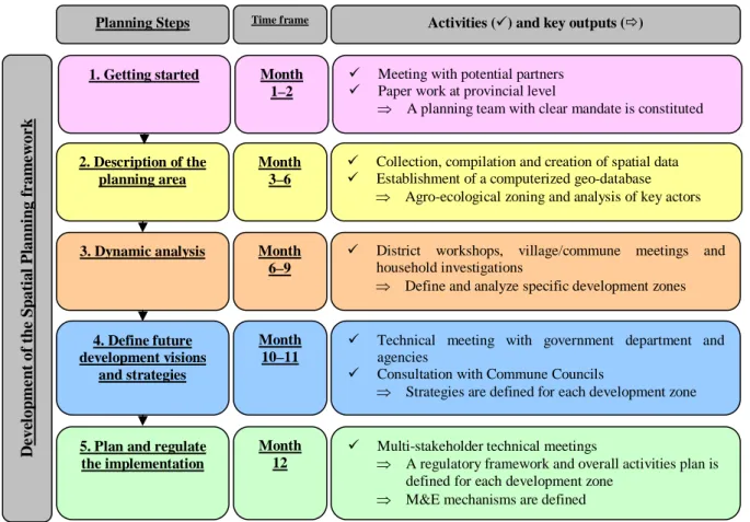
Figure 1. The overall planning process
Step 1. Getting started
After several consultations at the provincial level, in 2003 the governor issued a warrant to officially establish a Regional Development Plan Committee (decision-making committee) whose members consist mainly of the directors of most provincial departments. A sub-working group under the committee has been assigned the responsibility to facilitate the planning process at the working level. It consists of seven part-time staff coming mainly from the Department of Land Management. Their duties are to conduct all the situation and dynamics analysis necessary in a spatial planning exercise. On that basis, they have the mandate to draft the spatial planning framework. Based on a proposal from the sub-working group, the Regional Development Committee will approve the plan before it is submitted to the relevant ministries.
The German Development Service (DED) is advising the regional development planning committee and providing technical support to the sub-working group with two full-time advisors. Their main tasks are to propose capacity development activities that are in line with the planning process. In no way do they have any decision-making responsibility. The latter lies with the director of the department and eventually with the provincial governor and line ministries.
Step 2. Description of the planning area
The actual status of the province is to be considered as a basis for analyzing and planning. A relevant summary of spatial information, figures and facts needs to be addressed. This information, which forms the principal material for the analysis, is either derived from
2. Description of the planning area De v el o pm e n t o f t h e Spa ti a l P la nni ng f r a m e w o r k
5. Plan and regulate the implementation
4. Define future development visions
and strategies 3. Dynamic analysis
9 Collection, compilation and creation of spatial data 9 Establishment of a computerized geo-database
⇒ Agro-ecological zoning and analysis of key actors
9 Technical meeting with government department and agencies
9 Consultation with Commune Councils
⇒ Strategies are defined for each development zone 9 District workshops, village/commune meetings and
household investigations
⇒ Define and analyze specific development zones
9 Multi-stakeholder technical meetings
⇒ A regulatory framework and overall activities plan is defined for each development zone
⇒ M&E mechanisms are defined
Month 3–6 Month 12 Month 10–11 Month 6–9
Planning Steps Time frame Activities (9) and key outputs (Ö)
1. Getting started 9 Meeting with potential partners
9 Paper work at provincial level
⇒ A planning team with clear mandate is constituted
Month 1–2
existing documents (i.e. secondary data from ministries, international organizations, national or local NGOs) or directly generated by the sub-working group. Of particular relevance was the involvement of the team in the demarcation of all major tourism attraction sites (see map 1). The result of these comprehensive field surveys has served as input for the design of a specific "Plan for the Protection and Development of Tourism Sites"9 approved by the provincial governor.
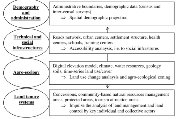
All geo-data are compiled, checked, re-projected if needed (Cambodia uses three different horizontal datum) and assembled in different geo-databases that are regularly updated (figure 2). A meta-database is constituted. Data processing is also instrumental in conducting the preparation of capacity development activities with the sub-working group staff.
Figure 2. Structure of the geo-databases
Map 1 shows the overlay of key land management features. It is based on an exercise of agro-ecological zoning, combined with the overlay of the important land tenure system and the overall space structure of the province. Geo-databases are upgraded with secondary tabular data from various sources (mainly from the Department of Planning and Agriculture). They are analyzed and when appropriate are mapped and then integrated into the geo-databases.
9
Regional Development Plan Committee Battambang (2008). “Plan for the Development and Protection of the Major Tourism Sites in Battambang Province.” With support from the Ministry of Land Management, KAS and DED
Administrative boundaries, demographic data (census and inter-censal surveys)
⇒ Spatial demographic projection
Demography and administration
Roads network, urban centers, settlement structure, health centers, schools, training centers
⇒ Accessibility analaysis, i.e. to social infrastrures
Technical and social infrastructures
Digital elevation model, climate, water resources, geology soils, time-series land use/cover
⇒ Land use change analaysis and agro-ecological zoning
Agro-ecology
Concessions, community-based natural resources management areas, protected areas, tourism attraction areas
⇒ Impulse the analysis of land management and land control by key individual and collective actors
Land tenure systems
7
The overlay of geo-data in a computer is a core element of the geographic information system and is routinely carried out by the sub-working group. But the access to such manipulation is not obvious. There are indeed significant barriers to be overcome before the data can be accessed. In terms of institutions, there is resistance to sharing information, as release of data is usually perceived as a loss of power. There are also financial constraints that the sub-working group faces to acquire updated data, especially recent land use/land cover data10. No GIS unit as such exists at the provincial level to facilitate the access to and distribution of geo-data. A positive side effect of the spatial planning process has been to establish such a provincial GIS unit that acts as a data service provider for various stakeholders, including from the public, private and academic sectors.
Step 3. Dynamic analysis
Dynamic analysis is undertaken in order to determine how the current land situation has been changing over time and is likely to change in the future. The development or non-development of specific areas in the province is dependent upon certain variables that can be influenced by the people or institutions in the province. There are other factors or conditions that can only be influenced at national level. The combination of all these factors has to be considered while undertaking a dynamic analysis11.
The dynamic analysis allows making the bridge between the understanding of land management in the past and the present challenges/conflicts in order to plan for the future. In this sense, it is the core activity in the planning process.
10 It should be mentioned that the GTZ-supported land management program has supported the team to acquire a recent (dry season 2008) LANSDAT 7 scene
11
Nikolaus Schall, Ed. (2006). Sub-provincial Strategic Land Management Development Planning, Planning Manual, GTZ-RGC.
Firstly, district workshops are conducted. Existing data are overlaid on an A0 size map to serve as a basis for discussion. District authorities and technical offices are requested to update the information contained on these maps simply by using tracing paper. Then, a discussion arises on the influential driving forces that have contributed to shaping the land to the situation existing today. The spatial distribution of each of the driving forces is mapped. The different driving forces are discussed and weighted to foresee the likelihood, magnitude and location of their occurrence in the future. Back at the office, the qualitative maps are reproduced, scanned, and geo-referenced. District geo-databases are digitized accordingly (map 2).
Twelve district workshops were organized. The discussions have basically highlighted four main driving forces:
⇒ Demographic growth through internal migration is putting considerable pressure on forest resources. These migratory movements are due to people arriving from all over the country. The relatively low price of land and the low demographic pressure are indeed attractive elements. The migration movement is poorly coordinated. Huge forest areas have been cleared for agricultural purposes. In the last five years, large human settlements and cropping areas have emerged as well. New villages are created with and without clear registration. Appropriation of State forest land is also done for speculative purposes.
⇒ In the context of steady population growth and limited access to additional land due to speculation, the challenge of the rural population has been to increase agricultural production at a pace at least consistent with the population growth rate. The historical logic so far has been to extend the cultivated area in order to increase food supply. In certain areas of the province, this is no longer possible. There, the agrarian systems are at a crossroads. The challenge for the rural population is then to intensify agricultural production by cultivating twice a year on the same plot. This implies improved water
9
control (i.e. drainage and irrigation). Indeed, such technical infrastructures are being built, mainly in the northern part of the rice plain.
⇒ A third chance factor started to occur on the Thai border with the clearance of huge areas of forest land in order to establish cash crop plantations (mainly red corn, cassava, green gram and sugar cane). The dynamic is triggered by traders, both Thai and Cambodian, and is infiltrating all upland areas of the province.
⇒ The fourth major factor of change is the endogenous management of common pool resources by the rural communities. This has been particularly clear in the Tonle Sap flood plain where access to a diversity of resources (i.e. deep water rice, fishing grounds, fuel wood and grazing lands) has been protected through the establishment of large community-based natural resources management land. In the forest area of the south, forest protection has been ensured via the strong involvement of local communities in the protected area (and rangers supported through international organizations).
After district discussions, village and household surveys are conducted to understand problematic land challenges experienced at the grassroots level. Investigation sites were selected in order to capture the agro-ecological and land tenure systems diversity observed at provincial level. Participatory Rural Appraisal exercises were conducted in 14 villages and detailed household investigation was conducted with a sample of 126 households12. The objective is to capture the diversity of farming systems and understand their differing contributions to the management of land. The information collected during the investigations allows the synthesis of the main constraints and challenges ahead for the rural population. A farming system typology is established (map 3) to assess the diversity and weight of different types of farming system in varying agro-ecological contexts. Extrapolated to the province with ad hoc and accurate data from a 2008 population census, this farming system typology provides useful information about the management of land at the household level. This provides first-hand information for the planning process.
12
At this stage, the validity of the sample is questionable. Additional household surveys will be conducted to reach a satisfactory level of representation. To that end, the cooperation with university students will be renewed as it brought very good results.
The qualitative maps, driving forces analysis and results of household surveys serve to determine specific development zones in the province. Defining development zones consists of defining areas where the dynamic, potentials and problems of land are singular. Initially, the definition of the zone relied on the qualitative maps as produced at the district level. But the result of a supervised classification from updated satellite image made it possible to re-adjust the approximate demarcation with accurate geo-data (map 4).
The boundaries of each development zone are discussed within the regional development plan committee and with commune councils.
Step 4. Define future development scenarios, visions and strategies13
Due to their uniqueness, the aim of the development zones is for them to serve as planning units. The zones represent spatial areas where similar development approaches can be implemented since similar situations exist there.
Each development zone is the focus of a discussion with technical department and commune councils. First of all, the diagnostic of the problems and potentials of each zone are refined with all participants before each zone is scrutinized. Planning is based on the preparation of decisions and the future actions. The spatial planning framework should account not only for the current but for future problems as well. Visualizing the future is essential to the planning process14. [Anticipating a] scenario can help make decision-making more robust and can help to identify strategies for pre-empting undesirable future developments.
13
The regional development planning team is in the middle of this step. This section will only present the concepts and general process. Content wise, limited information can be shared at this stage.
14
Schall, N., (Ed.) (2006). Sub-provincial Strategic Land Management Development Planning, Planning Manual, GTZ-RGC.
11
Furthermore, stakeholders try to establish a clear vision for each development zone. The vision represents a future ideal state of affairs that can or should be pursued within the 20-year planning period. Visions define how all stakeholders perceive the future of the district. Visions are bold development statements. They represent something towards which the communities are striving15.
Step 5. Plan and regulate the implementation16
Once the overall provincial development strategies and the different sectoral strategies are defined, the strategic framework is somehow translated into an activity plan to which all relevant technical departments, NGOs, private sector companies as well as local authorities agree to contribute. They do so within the scope of their capacity and will. The exercise doesn't aim to re-invent the wheel but mainly to integrate the existing activities, projects and programs into a framework that has a clear vision and clear mechanisms for monitoring.
5 Towards spatially enabled governments
The implementation of the spatial planning framework remains an open question, asked in a positive tone. Even though the process has until now run quite smoothly, it would be presumptuous to conclude, at this stage, anything about the outputs. All the work is still very much under construction. Some concluding remarks can be made on the conditions that need to be met to put the plan into effective practice.
A cornerstone of the planning process has been participation. The successes of the implementation of the spatial planning framework will intrinsically depend on how the people consulted during the planning process will benefit from it.
⇒ Consultation with rural communities, which the spatial framework is aiming at, will be crucial to assess and measure success. As a result of proper planning and a more transparent basis for decision-making, rural resources are supposed to be more efficiently used and the rural livelihoods are supposed to improve. Only the future will tell…
⇒ The way that technical departments will integrate the decentralisation and deconcentration reform remains largely unknown. This will influence the extent to which they will be willing to join forces in a provincial development council, rather than with their line ministries. In the end, the use of a spatial planning framework as a reference document will very much depend on it. The chances of success can be maximized if the technical department benefits from the plan. Once completed, the involvement of the sub-working group should be reinforced towards a more tailored-made service to the technical department (including mapping and capacity development) to accompany the process.
⇒ On the basis of the spatial planning framework, local authorities at district and commune levels will need to elaborate more detailed land use plans. In that matter, the socio-agro-eco boundaries of the development zones will need to be translated into administrative boundaries.
This implies that efficient mechanisms (quick and cheap to implement) are elaborated for monitoring and evaluation. The provincial development council has a mandate to follow up
15
ibid.
16
on the recommendation and regulations. But given the large area involved, this should be coupled with easy land cover monitoring. Two promising signals are the free-of-charge recourse to spot-vegetation (very weak spatial resolution –1 km, but excellent temporal resolution – 10 days) and free access to the US Landsat image from 2009 onwards.
Bibliographical notes
Ayres, D. (2005). Decentralization and Deconcentration Strategic Framework. Internal RDP discussion paper, Phnom Penh, 34 p.
Council of Land Policy (2002). Interim Paper on Strategy of Land Policy Framework, Phnom Penh, 40 p.
Food and Agricultural Organization of the United Nations (1993). Guideline for Land Use
Planning. Soil Resources, management and conservation service, Rome, 96 p.
Kingdom of Cambodia, (2008). Law on Administration and Management of the Capital,
Province, Municipality, District and Khan.
Mueller, F.V. (2008). Land policy development in Cambodia: Status, process and challenges. GTZ land management and allocations projects, internal discussion paper.
Pellini, A. (2004). Decentralization policy in Cambodia: the main actors. DED Cambodia – PRDR Kampong Thom, Kampong Thom, 16 p.
Prum, S. (2000). In Minutes of workshop on the impacts of decentralization and elected
commune councils on the development programs of NGO.
Regional Development Plan Committee – Battambang (2008). Plan for the Development and
Protection of the Major Tourism Sites in Battambang Province, Battambang Province, 138 p.
Schall, N. (Ed.) (2006). Sub-provincial Strategic Land Management Development Planning,
Planning manual, GTZ-RGC, Phnom Penh, 34 p.
Symann, R. (2008). Capacity Building in der lokalen Verwaltung am Beispiel Battambang,
Kambodscha, DED Newsletter, Bonn
Author Biography
Jean-Christophe DIEPART (Belgian - 32 years old), has been working in Cambodia for the last seven years. He has been successively University Advisor at the Royal University of Agriculture in Phnom Penh, Natural Resources Management advisor in Kampong Thom and Land Use Planning advisor in Battambang province with the German Development Service. He holds an Engineering Degree in Agronomy (Land Management) and an MSc degree in Rural Development Studies. In 2007, he got a PhD in Rural Economics from the Gembloux Agricultural University (Belgium). His professional interests lie with integrated rural development programs and the promotion of peasant initiatives