HAL Id: hal-00207769
https://hal.archives-ouvertes.fr/hal-00207769
Submitted on 18 Jan 2008HAL is a multi-disciplinary open access archive for the deposit and dissemination of sci-entific research documents, whether they are pub-lished or not. The documents may come from teaching and research institutions in France or abroad, or from public or private research centers.
L’archive ouverte pluridisciplinaire HAL, est destinée au dépôt et à la diffusion de documents scientifiques de niveau recherche, publiés ou non, émanant des établissements d’enseignement et de recherche français ou étrangers, des laboratoires publics ou privés.
3D modeling and dielectric characterization of geological
profile. Application to the improvement of the study of
moisture of grounds by radiometry
François Demontoux, Maria-José Escorihuela, Jean-Louis Miane, Gilles Ruffié,
Jean Pierre Wigneron
To cite this version:
François Demontoux, Maria-José Escorihuela, Jean-Louis Miane, Gilles Ruffié, Jean Pierre Wigneron. 3D modeling and dielectric characterization of geological profile. Application to the improvement of the study of moisture of grounds by radiometry. ICMS’05 - interntional conference on Modeling and Simulation - Marrakech - Maroc, Nov 2005, Morocco. pp.50. �hal-00207769�
3D modeling and dielectric characterization of geological
profiles. Application to the improvement of the study of the
moisture of grounds by radiometry.
JL. Miane*, F Demontoux *, G.Ruffié *, J.P. Wigneron ** , Maria - José Escorihuela *** * PIOM-ENSCPB-UMR laboratory 5501- 16 av. Pey-Berland 33607 Pessac - France
** INRA-Unit of Bioclimatologie, LP 81, Villenave d’Ornon Cedex 33883 - France *** CESBIO 18 avenue. Edouard Belin, bpi 2801 31401 Toulouse cedex 9 - France
Abstract : The surface moisture of the ground is an important parameter to describe the exchanges of water and energy between the ground and the atmosphere. Studies have showed that passive microwaves sensors could be used to scan the moisture of surface of the grounds. The solution which has been retained by the team associated with mission SMOS ( Soil Moisture and Ocean Salinity) consists in using a radiometer (1.4 GHz) in order to improve the knowledge of the microwaves emissions of the grounds. Thanks measurements it is possible to know an equivalent permittivity of the measured grounds. However, the effect of the cover of vegetation, the temperature of the ground, the snow cover, the topography or the variations of moisture have a considerable role in the microwave emission of the surface. The objective of this work which we present in this paper is to develop a numerical model to simulate complex geological structures. The goal of this model is to characterize these geological structures by calculating their equivalent permittivity in order to be able to associate each measurement of the radiometer to an equivalent moisture.
1. Introduction
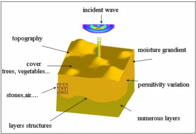
The surface moisture of the ground is an important parameter to describe the exchanges of water and energy between the ground and the atmosphere. In hydrology and meteorology, the quantity of water contained in the upper layers of the ground (0-5cm of surface) makes it possible to evaluate the relationship between real evaporation and potential evaporation on the level of a naked ground. It is also possible to determine the distribution of the rain to surface streaming waters or "stored" water or other variables like hydraulic conductivity. Studies have showed that passive microwaves sensors could be used to scan the moisture of surface of the grounds. The solution which has been retained by the team associated with mission SMOS (Soil Moisture and Ocean Salinity) consists in using a radiometer (1.4 GHz) [ 1 ] in order to understand the microwave emissions of the grounds. Measurements have been made on the site of the CESBIO in Toulouse (France) where a 1.4GHz radiometer is installed permanently. These measurements make it possible to know an equivalent permittivity of the measured grounds. However, the effect of the cover of vegetation, the temperature of the ground, the snow cover, the topography or the variations of moisture have a considerable role in the microwaves emission on the surface. Other parameters like the presence of inclusions in the ground (holes, stones) or textures of the ground can also disturb measurements.
The goal of the work we present in this paper is to develop a numerical model to simulate complex geological structures. This model must take into account the whole of the parameters which can influence the equivalent permittivity measured by the radiometer (surface quality, variation of moisture, inclusions...). The goal of this model is to calculate the equivalent permittivity of these geological structures in order to be able to associate each measurement of the radiometer to an equivalent moisture.
2. Characterization
The first part of our work has consisted in making forward and backward scattering measurements of samples of agricultural grounds placed in a wave guide in order to know their permittivity between 1.3 GHz and 1.5 GHz.
The second stage consisted in developing a process of characterization of ground. In a box of 1m 3 we built a simple geological structure. A back scattering measurement with a horn antenna makes possible to obtain the equivalent permittivity of the material. Once the validated process, we will take in situ measurements.
These results will make it possible to begin the study of the variation of permittivity of these various grounds according to the moisture. They also make it possible to validate the first results obtained using our model
JL. Miane,, F Demontoux, 3D modeling and dielectric characterization of geological profiles.
2
Application to the improvement of the study of the moisture of grounds by radiometry.
3. Development of the model
The finality of this model is to supplement measurements in order to characterize the geological structures [ 2 ]. Thanks this model it is possible to study the equivalent permittivity of grounds by representing the experimental measurement taken into account the horn antenna. It must also take into account many parameters like topology, the presence of heterogeneities (holes, stones....) or the variations of moisture. It will also be possible to study a sufficiently large surface.
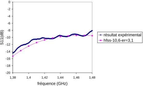
The first studies were carried out with the HFSS-ANSOFT software. It uses the finite element method. It allows a first study by taking into account a homogeneous ground. This first study simulates the experiment we use at the laboratory. It enables us to study the scattering response of various materials (Fig. 1).
Fig. 1 : Simulation of the experiment used at the laboratory
The figures 2 and 3 present the results of the module and the phase of the backscattering coefficient standardized by a measurement on a short circuit. The comparison of the experimental results and those resulting from simulations show a good correlation.
Application to the improvement of the study of the moisture of grounds by radiometry. -20 -18 -16 -14 -12 -10 -8 -6 -4 -2 0 1,38 1,4 1,42 1,44 1,46 1,48 fréquence (GHz) S1 1( d B ) résultat expérimental hfss-10,6-er=3,1
Fig. 3: Back-scattering calculation and results of measurement (module).
Complementary calculations on various materials have permit to evaluate the sensitivity of the variation of the S11 parameter according to the properties of the product (Fig. 4).
-20 -18 -16 -14 -12 -10 -8 -6 -4 -2 0 1,35 1,37 1,39 1,41 1,43 1,45 1,47 1,49 Fréquence (GHz) module S11(dB) er=3,1 er=3,3 er=3,5 er=3,9 er=5
Fig. 4: Simulations of various materials
These first studies give us very significant information on the results which we will obtain when we will make measurements on grounds of very different moisture. Unfortunately this step does not enable us yet to evaluate the influence of parameters like the gradients of moisture, the presence of air or the nature of the studied layers. To introduce all these parameters we planned the development of another model of calculation.
The method of simulation that we chose for this new model is the FDTD method (Finite Time Domain method) [ 3 ]. It is a method which has the advantage of allowing the introduction of the whole of the functions of our model (Fig. 5). This method has however the defect to be very greedy in memory because of the great number of meshes of calculations necessary to simulate our problem correctly. This significant number of mesh comes first of all from the precision with which we wish to represent the forms of the objects and a minimum number of cells to be used by wavelength for a good application of the algorithm of resolution. These problems can be avoided by the use of a grid with variable step and a super calculator SGI Altix 3300 with 12 processors and 16Go of RAM available to the ENSCPB. A study of a surface from 200 to 300 m 2 is then possible.
Another limitation of this method is based on the type of source used. It is possible to represent our horn antenna in order to simulate our experiments. Unfortunately we limit our resources memory to represent the
JL. Miane,, F Demontoux, 3D modeling and dielectric characterization of geological profiles.
4
Application to the improvement of the study of the moisture of grounds by radiometry.
remainder of our problem. Another approach consists in generating a plane wave on our geological structure. In this case we do not cut down our data-processing resources but we simplify the behavior of our horn antenna and we move away our model from reality. We considered a third possibility which consists in generating an electromagnetic source as a plane source without representing the antenna but with a behavior witch is closed to the characteristics of the horn antenna. The problem of meshing the antenna or using a plane wave is then avoided. The numerical approach we have used can be defined as an extension of the Huygens surfaces. We can obtain various radiation diagram of the source.
Fig. 5 :3D FDTD model
4. Example of results
The model must take into account various parameters of the topology. Those parameters are known (topography, layers…). At the end of our study, the model will represent the topology of the geological structure and the variation of the moisture (permittivity, gradient) will permit to find the equivalent permittivity of the structure measured by the radiometer. The surface moisture of the structure will be known.
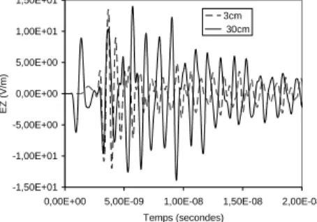
The first step of our work has been to verify that our model takes correctly into account all the parameters. One of the first results we have obtained is the studied of the effect of the surface topography (Fig. 6) on the backscattering (reflection, depolarization). The incident field is polarized according to the Y axe direction. Its amplitude is 1000 V/m. It is a Gaussian pulsed wave modulated at 1.4 GHz (T=0.7 ns).
Fig. 6 : View of the topography calculated
The figure 7 presents the variations of the amplitude of each component of the electric field reflected by the geological structure. Each result is classified by the height between the lowest and the highest point of the topography. For example, 0cm corresponds to a flat structure.
Application to the improvement of the study of the moisture of grounds by radiometry. -1,50E+01 -1,00E+01 -5,00E+00 0,00E+00 5,00E+00 1,00E+01 1,50E+01
0,00E+00 5,00E-09 1,00E-08 1,50E-08 2,00E-08
Temps (secondes) E X ( V /m ) 3cm 30cm
Reflected field along X polarization
-1,50E+01 -1,00E+01 -5,00E+00 0,00E+00 5,00E+00 1,00E+01 1,50E+01
0,00E+00 5,00E-09 1,00E-08 1,50E-08 2,00E-08
Temps (secondes) E Z (V/m) 3cm 30cm
Reflected field along Z polarization
-5,00E+01 -3,00E+01 -1,00E+01 1,00E+01 3,00E+01 5,00E+01 7,00E+01 9,00E+01
2,00E-09 4,00E-09 6,00E-09 8,00E-09 1,00E-08 Time (seconde) EY ( V /m ) entY3 3cm entY1 30cm
Reflected field along Y polarization
Fig. 7: reflected field according to the polarization
The increase of topography causes depolarization of the reflected field. Those results correspond to the results we expected to obtain. Thanks those data it will be possible to obtain the backscattering parameter of the structure according to the frequency using a Fourier transform. It is also possible to evaluate the height of the topography by measuring the time between the departure of the incident wave and the arrival of the first signal backscattered.
5. Conclusion
We will present the experimental results and those resulting from our model to begin the dielectric characterization from various geological structures according to the moisture. Moreover, this geological model will permit, according with experiments, the development of news measurements techniques to analyze low perturbations of the electromagnetic responses of geological structures. It will permit the detection of small dielectrics gradients or little inclusions in complex geological structures.
Reference
[1] J.P. Wigneron J.C. Calvet T. Pellarin A.A. Van de Griend M. Shepherd, P. Ferrazzoli " Retrieving
near-surface soil moisture from microwave radiometric observations: status and future plans ", Remote Sensing
of Environment 85 current (2003) 489-506
[2] E. Heggy ., P. Paillou, F. Suit N. Mangold G. Ruffie F. Demontoux , J. Grandjean J.M. Malezieux " Local geoelectrical models of the Martian subsurface for shallow groundwater detection using sounding
radars "
Journal.Geophys.Research 2003, vol108n°E4,10.1029/2002JE1871
[3] K.S.KUNZ, R.J.LUEBBERS. The finite difference time domain method for electromagnetics.CRC PRESS(1993)