THE REMNANTS OF YOUNGER DRYAS LITHALSAS ON THE
HAUTES FAGNES PLATEAU IN BELGIUM AND
ELSEWHERE IN THE WORLD
Albert PissartUniversity of Liège, 29, rue Lavaux, 4130 Esneux, Belgium
KEYWORDS: Periglacial mounds; Palaeoclimatic reconstructions; Lithalsas; Belgium; Wales;
Ireland. ABSTRACT
This paper summarizes all the available information about the “viviers” of the Hautes Fagnes, i.e., closed and ramparted depressions which are numerous above 500 m a.s.l. on the highest Belgian plateau. These features and cross-sections in the ramparts are described. The ramparts are the result of both mass wasting on the slopes of the mounds and toppling of inside material. 14C
dating of a peat layer preserved under a rampart, Alleröd volcanic ashes and palynological studies have proved that the “viviers” formed their origin during the Younger Dryas. In the first place, the depressions were interpreted as excavations by prehistoric men; from 1956 on, they were interpreted as pingo remnants. The pingo hypothesis is now abandoned. The “viviers” are remnants of mineral palsas (lithalsas), features which nowadays exist in Hudsony (Canada). Present-day lithalsas are solely known in subarctic Quebec and in Lapland. They form in the discontinuous permafrost zone, close to the tree line, i.e., in zones where mean annual temperature (MAT) ranges from − 4 to −6 °C and where the average temperature of the warmest month is between +9 and +11.5 °C. Such climatic conditions are rarely encountered nowadays in periglacial regions. Remnants of lithalsas are very infrequent, too. They appear like ramparted depressions forming clusters. Such traces, dating from the Younger Dryas, have been described only at elevation above 500 m a.s.l. on the Belgian Hautes Fagnes Plateau, around 250 m a.s.l. in Wales and at sea level in Ireland. In these few places, according to R. Isarin’s palaeoclimatic results, climatic conditions during the Younger Dryas were similar to present-day conditions in subarctic Quebec, where lithalsas are numerous.
1. The Hautes Fagnes Plateau “viviers”: description and
localization
The Hautes Fagnes Plateau, in Belgium, is a Cambrian massif consisting of quartzites, phyllites and quartzo-phyllites. These ancient rocks are locally superficially weathered and phyllites have been transformed into clays. Part of this weathering took place before the Cretaceous. The summit line of the Hautes Fagnes fits transgression surfaces, first a Cretaceous one (there are remains of clay with flint), then Tertiary (some Oligocene sands were left over). However, most of the time, Cambrian rocks are only irregularly covered by aeolian silts which are more or less altered and mixed with some Cambrian rock debris.
On the Hautes Fagnes Plateau, and chiefly on its northern slope, a large number of closed and ramparted depressions called “viviers” are observed at elevations over 500 m, over an area of 37.1 km2 (Fig. 1). The simplest forms are found on almost horizontal surfaces; they are circular
or egg-shaped (Fig. 2a).
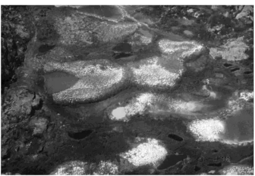
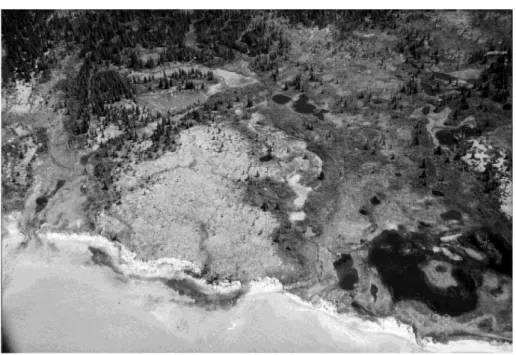
Some diameters can reach 150 m. The major axis of the oval features is up to 250 m. Some depressions have an irregular shape (Fig. 2b), with a rim around them. The rims are commonly less than 1 m high, but some are several meters high (Fig. 3). The ramparts appear very clearly on aerial photographs because, as they are dryer than the surrounding moor, they are colonized by a different vegetation (Fig. 4). On the slanting surfaces, such “viviers” exist only on slopes less than 5%. They often extend along the steepest slope line. Even if the rampart is still very apparent downwards, it fades upwards and even disappears: such ramparts are U-shaped, like horseshoes (Fig. 2d).
On a few slopes, some ramparts are up to 800 m long (Fig. 2c). Locally there are some very complex forms, crisscrosses of rims and hollows from which it is impossible to reconstruct the individual depressions (Fig. 2b and c).
The depth of the hollows is variable. They always contain peat and their maximum depth is 8 m. Identical, but less numerous, features have been observed on the Baraque de Fraiture Plateau, another Ardennes massif located about 30 km southeast of the Hautes Fagnes Plateau (Fig. 2a). Here too the depressions are at elevation higher than 500 m. The bedrock is composed of Cambrian and Devonian weathered rocks lying covered by more or less recasted aeolian silt.
2. Performed diggings
Thanks to research grants from the Fonds National de la Recherche Scientifique (FNRS—Belgian National Fund for Scientific Research), diggings have been realized through about 10 well-developed ramparts and all observed cross-sections have been published (Pissart, 2000). Each rampart is composed of very heterometric material: aeolian silt surrounding debris and blocks coming from the Cambrian bedrock. The most interesting section is shown in Fig. 5. It was cut through the lowest part of an elongated form located in Konnerzvenn, near the German border
(800 m to the east of the Eupen–Monschau road) and its detailed description was published in 1980 (Pissart and Juvigné, 1980). A 30-cm-thick peat layer was found in the rampart.
Fig. 1. Map of the distribution of the “viviers” in the Belgian Hautes Fagnes. The “viviers”, which are lithalsa remnants, are known on the Hautes Fagnes and Baraque de Fraiture plateaux. They are found at elevation above 500 m a.s.l., except some depressions south of Spa, located between 460 and 500 m a.s.l. From Pissart (2000), reproduced with permission.
Fig. 2. Diversity of “viviers” look on aerial photographs: (a) circular or oval “viviers” on the Baraque de Fraiture plateau; (b) crisscrossed ramparts on the Vecquée ridge, south of Spa; (c) complex forms, with very elongated ramparts extending according to the slope, in Steinley (between Konnerzvenn and Konzen); (d) horseshoe shapes, east of Steinley.
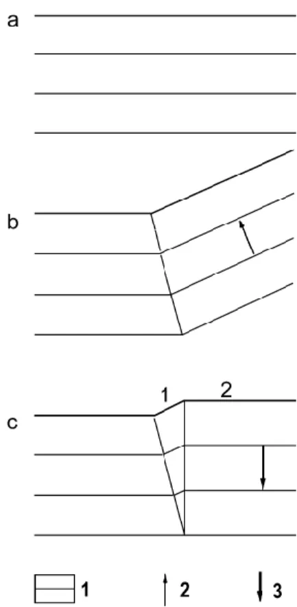
From the drawing of the cross-section, it is possible to reconstruct how the rampart formed (Fig. 6). At the beginning, a wet hollow existed there and peat accumulated in it (Fig. 6a). As ice developed in the ground, a protrusion appeared nearby and fine silts, moved by runoff, covered the peat layer. The maximum thickness of the silt layer at X gives evidence of the position of the concavity (Fig. 6b). As the mound grew further, the concavity moved laterally, as shown by the maximum depth of the silt layer at Y (Fig. 6c). The continuing accumulation of ice led to steeper gradients and silty material slipped down by solifluction, together with blocks and even large quartzite boulders (Fig. 6d,e and f). These mass movements upturned the peat layer and solifluction bulges appeared at the upper part of the slope. Finally, the melting of the ground ice induced a vertical collapse of the mound and the formation of the depression in which peat would later accumulate (Fig. 6g, showing present-time aspect).
Even if this figure clearly shows that the rampart, for the most part, was formed by material that slipped on the slopes of the periglacial mound, a comparison of sections a and g (Fig. 6) indicates an additional process. The base of the peat layer was horizontal before the growth of the mound; the layer was deformed while the mound melted away. In the latest stage, an unmistakable step proves that some heaving occurred under the peat. The most likely explanation is that, during the periglacial mound growth, heaving in the deeper formations was not vertical, but oblique. On the other hand, when the ice melted, its collapsing was vertical. Fig. 7 shows how the thickness of the deep layers increased. As a whole, at the location of this section, 4/ 5 of the rampart results from material slipping on the slope and 1/5 from thickening of deep layers.
Other cross-sections in ramparts, either circular or elongated, are generally like the profile of Fig. 5, but no other one displays a peat layer. Only one section is dramatically different (Pissart, 1983): it is constituted of piled-up solifluction lobes (Fig. 8).
3. Age determination of these periglacial mounds
When did these periglacial features form? The answer to this question clearly derives from the section of Fig. 5. Formerly, the only age determination data available were palynological profiles of the material filling the depressions, and it was impossible to date the depression formation. Some people opined that the Hautes Fagnes “viviers” had appeared during the Younger Dryas, while others assumed that they were older. In order to go back as far as possible in the past, not only the pollen from the peat has been studied, but also the pollen trapped in the clay, at the bottom of the depressions. As soon as 1938, Florschutz and Van Oye (1938), who had found in such a clay some remains of cold climate plants, e.g., Selaginella selaginoides Link, thought the filling had begun during the Late Glacial. One year before, Bouillenne et al. (1937) suggested the filling had begun at the Preboreal. Palynological studies went on until 1975 and defended
conflicting opinions: Florschütz and Van Oye (1939), Van Oye and Florschütz (1946) and Woillard (1975) disagreed with Van der Hammen (1953) and with Slotboom (1963), who thought that the depressions dated back to the end of the Younger Dryas. Bastin et al. (1974), who had found pollen in a silty layer in the first cross-section cut in a rampart, declared the features pleniglacial. To give a complete view of the elements that were available before 1980, let us add that Mullenders and Gullentops (1969), using tephrostratigraphy, said these periglacial forms dated back to the Younger Dryas: volcanic ashes from the Alleröd eruption had been found in the rampart but not in the bottom deposits of a depression of the Baraque de Fraiture plateau (Mullenders and Gullentops, 1969).
Fig. 4. Picture of a group of “viviers” in Brackvenn, near the Eupen–Monschau road, close to the German border. Most “viviers” are circular.
Fig. 5. Section through the down slope end of an elongated rampart in Konnerzvenn. Two peat layers are drawn in black. The upper layer (1) is the Holocene filling. The layer (2), inside the rampart, is an Alleröd peat layer, which formed before the periglacial mound growth began. Three 14C datations are provided: 11030 years BP corresponds with the volcanic ashes from the Laacher See eruption.
Fig. 6. Reconstruction of the formation of Fig. 5 rampart. (a) Profile before the lithalsa appeared; it shows the Alleröd peat layer—(g) present-time profile. The rampart is mainly constituted by materials having slid down the slopes of the periglacial mound. The deformed base of the Alleröd peat layer suggests the intervention of another process, which is explained in Fig. 7. From Pissart (2000), reproduced with permission.
Finding a thick peat layer older than the rampart, in the section shown in Fig. 5, definitely established (Pissart and Juvigné, 1980) that this periglacial mound appeared during the Younger Dryas and that the depression filling occurred only during the Holocene. This peat layer has, indeed, been dated by 14C, tephrostratigraphy and palynology.
Fig. 7. Ground ice accumulation has pushed aside the deep layers, increasing their thickness. From Pissart (2000), reproduced with permission.
Fig. 8. Unique section of a rampart made of piled-up solifluction lobes.
3.1.
14C AGE DETERMINATION
Obtained age determinations are given hereafter (laboratory abbreviations and dating numbers are put into brackets). Base of the peat layer: 12170 ± 90 years BP (GrN9258) and 12710 ± 180 years BP (Lv1012). Level of Alleröd volcanic ash—from Laacher See—in the peat: 11030 ± 160 years BP (GrN8891), 10830 ± 45 years BP (GrN10579) and 10820 ± 150 years BP (Lv1011). Top of the peat layer: 10640 ± 130 years BP (MBN191) and 10320 ± 70 years BP (Beta122423).
3.2. TEPHROSTRATIGRAPHY
E. Juvigné (Pissart and Juvigné, 1980) has found, within this peat layer, a very thin, but clearly visible, bed of volcanic dust that was identified as originated from the Laacher See, a “maar” of Eifel, located 100 km east of the Hautes Fagnes Plateau. According to varve study in the Eifel
“maars” and in Swiss lakes (Hajdas et al., 1995), the volcano erupted some 200 to 300 years before the beginning of the Younger Dryas, thus in 11230 ± 50 years BP, during the Alleröd.
3.3. PALYNOLOGY
The pollen diagram of the peat layer discovered under the Konnerzvenn rampart was only published by Bastin in a Belgian regional journal (Bastin, 1985), 5 years after the section results had been published. Bastin picked up samples as early as 1978, when the trench was cut, and carried out pollen studies from 1979 on (date indicated on the diagram). The results of this study contradicted former papers and were even discordant to previous conclusions of Bastin himself (Bastin et al., 1974) and of Woillard (1975), who was working in the same lab.
The pollen diagram is shown in Fig. 9: 29 samples, collected 1 cm apart through the peat layer, had been examined by Bastin. On this diagram, the easiest approach is the variation in arboreal and non-arboreal pollen content. At the base of the section, the percentage of trees is 85% and it decreases when moving higher up. This part of the diagram was interpreted by Bastin as representing the end of the Bölling. Then probably follows the Middle Dryas, a cold period during which there was less trees and the amount of Selaginella became important. Afterwards, the amount of tree pollen increases a lot (particularly Pinus); this testifies of the higher temperatures during the Alleröd, the period of time during which volcanic ashes from the Laacher See got deposited. In the upper 5 cm of the peat layer, arboreal pollen decreases dramatically, an effect of colder conditions during the Younger Dryas. This cooling is responsible for the ground heaving by expanding ice, and therefore, for the burying and preservation of the peat layer.
Fig. 9. Pollen diagram of the peat buried under the Konnerzvenn rampart shown in Fig. 5. This diagram was drawn by Bastin in 1979 and published in 1985. Samples were collected 1 cm apart through the peat layer. This diagram extends from the end of the Bölling to the beginning of the Younger Dryas. Volcanic ashes from the Laacher See eruption are represented in this figure (Bastin, 1985).
4. Possible origins successively proposed for these closed
depressions
4.1. HUMAN ORIGIN
Very early, the closed depressions attracted the attention of people wandering through the Hautes Fagnes and appealed to their imagination, giving way to varied hypotheses about their origin. Bouillenne et al. (1937, p. 405) wrote (translated): «as fancy ideas about the origin of the Hautes Fagnes “viviers”, people talked about drinking troughs, fish ponds, water tanks, gold jigging, quarries, pile dwellings, terramares, big game traps, depressions linked to volcanic activity». In the same paper, which was the first scientific study dedicated to those features, the conclusion was that the “viviers” (French word meaning “fish ponds”) are the work of prehistoric men: «It is not logical to accept that a natural phenomenon could organize depressions in such a way, carrying off the surface silt from a place and accumulating it in a regular round rampart. An important and organized human community was necessary in order to move so many thousands of cubic meters of soil and stones and, to fashion circular ramparts around primitive wood buildings on piles.» (Bouillenne et al., 1937, p. 413).
We shall not linger over the remnants of wood buildings in the “viviers”. These descriptions are not sufficient to make a decision about the human hypothesis and they do not prove that human beings dug the depressions. These hypothetical buildings might indeed have been erected in pre-existing bowls.
Bouillenne et al. (1937) used the word “viviers” in the title of their paper and, from then on, this term asserted itself for the closed depressions of the Hautes Fagnes, even if it is nowadays certain that this term has nothing to do with the true origin of the forms.
The 1937 paper was, however, very interesting because it included a first palynological analysis of the material lying in the depressions. This analysis showed that the depressions existed already at the very beginning of the Holocene, the same conclusion as Florschütz’s, also published in 1937 and mentioned above.
4.2. PINGO REMNANTS
In 1956, a natural, periglacial, genesis was proposed to explain these features (Pissart, 1956, 1963). The new hypothesis was that the ramparted depressions were traces of pingos, in other words, periglacial mounds moved upwards by the accumulation of ground ice. Such mounds can reach a height of 50 m in the Mackenzie delta. The materials covering them go down their slopes simply by gravity effect, and, after the ice has melted out, ramparted depressions appears, as described by Frazer (1956).
Pingos appear because of injection ice forming in the ground. Two different types exist: closed system ones and open system ones.
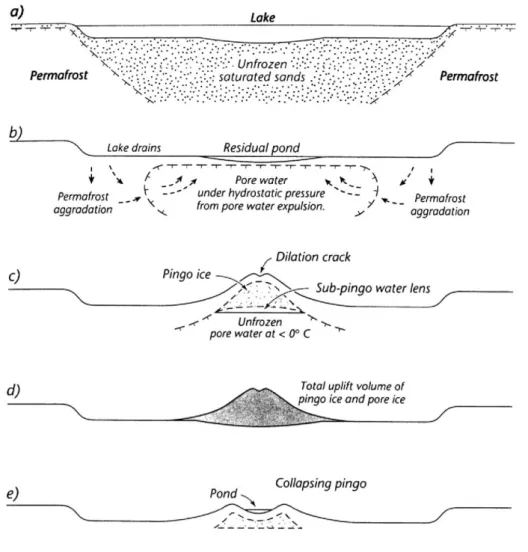
Closed system pingos—or Mackenzie type pingos—have been studied in detail by Mackay (1998) (Fig. 10), who explains their growth by the presence, under the lakes of the Mackenzie delta, of pockets of unfrozen sediments surrounded all around by frozen ones. A gradual freezing
of these unfrozen pockets leads to pressurization of the remaining water and part of it is squeezed out and injected into the superficial layers, which are pushed upwards. The injected water then turns into ice, called injection ice.
Fig. 10. Diagrams of Mackay (1998) explaining the formation of closed system pingos, or Mackenzie Delta pingos. Diagram c shows the position of the injected water lens that will turn into ice. Diagram e describes the partial melting of the pingo ice immediately under a central pound formed on the mound top (copy of Fig. 4 in p. 277 from Mackay, 1998).
In an open system, at the lower part of slopes, water gets pressurized between the superficial permafrost and the impermeable substratum (Holmes et al., 1968; Hughes, 1969) (Fig. 11). Water pressure building is here linked to this hydrostatic system. Like in a closed system, some water is injected into the superficial layers, which are gradually moved upwards and form pingos located at the base of slopes.
Fig. 11. Formation of open system pingos. Water flows between bedrock and permafrost and is injected into the surface layers at the base of the slope (copy of Fig. 9 from Holmes et al., 1968).
Depressions similar to the Belgian “viviers” have been later described in Wales (Pissart, 1963) and stratified layers were observed in a rampart. This stratified structure has proved the natural genesis of the ramparts and has definitely put aside the hypothesis of a human origin.
4.3. FURTHER DOUBTS: 1972–1984
During the following years, after the Canadian Arctic pingos had been studied (Pissart, 1967), it became obvious that the Hautes Fagnes depressions could not be considered any longer as pingo remnants (Pissart et al., 1972, 1975; Pissart, 1965, 1974, 1976). Indeed, on the Hautes Fagnes Plateau, there are no traces of lakes, and we have stressed that lakes are necessary for the formation of closed system pingos. Concerning the open system pingos, they grow only at the base of slopes, but in the Hautes Fagnes region, “viviers” are found on narrow crests surrounded by no higher slope! Furthermore, drillings have revealed that some Hautes Fagnes “viviers” are located in places where no sandy or gravelish formation exists at depth; the occurrence of such formations is necessary for water injection to occur. Last but not least, in the Arctic, there is no site where the density of pingos (their number per km2) is as high as the density of the Belgian
“viviers”, which are contiguous to each other on several square kilometers.
These objections led us, as soon as in 1972, to the idea that the cryogenic mounds which have existed on the Hautes Fagnes Plateau were not remnants of typical pingos resulting from the formation of injection ice. A few years later, we gave some more details (translated): «the “viviers” of the Hautes Fagnes must, from now on, be considered as traces of mounds consisting chiefly of segregation ice. As the aquifer providing water to the growing mounds had to be supplied, permafrost had then to be discontinuous. The mounds were probably islands of permafrost...» (Pissart, 1976, p. 134).
4.4. REMANTS OF LITHALSAS (MINERAL PALSAS)
At the end of the 1960s, the only periglacial mounds that were known, besides the pingos, were the palsas. They are lower than the pingos (around 10 m high as a maximum) and they had been
found and described in peat bogs only. The type of ice that accumulates in such mounds is segregation ice, whose origin will be first briefly accounted.
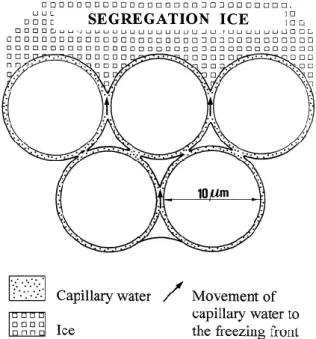
Segregation ice is made of lenses that grow in fine granulometry soils. The word “segregation” recalls the separation, in the soil, of water from mineral material, in the same way as sexual segregation means separation of men and women. Ice lenses form within the soil because of water migrating in the capillaries, like it happens in a drying soil. When a soil is exposed to the sunrays, its water content decreases not only near the surface, but also in its whole upper part. Water, in these circumstances, migrates upwards through the capillary film. When a soil freezes, a similar process takes place: the thickness of the capillary film round the soil particles decreases where water turns into ice, that is next to the growing ice lenses; the tendency to reconstitute capillary films induces migration of water towards the freezing front (Fig. 12). The only difference with the evaporation process is that freezing water remains in the soil in a solid state; on the contrary, evaporating water disappears in the atmosphere. Let us emphasize here the surfusion phenomena. Very often, the ability of liquid water to migrate through the capillaries at temperatures lower than 0 °C implies that migration can go on. Water migration towards the freezing front is called cryosuction.
Fig. 12. Schematic representation of how segregation ice lenses are fed by water migrating through the soil capillaries.
Cryosuction, and thus segregation ice formation, are possible under the following indispensable conditions:
(1) Presence of water in the soil.
(2) Soil granulometry allowing existence of capillary water. Silt is the best sediment. In coarse sands, there is no capillary film and no segregation ice can form. In clays, poor permeability induces a very slow water migration and is not favourable to ice lenses formation.
(3) Slow freezing. If freezing is too quick, capillary water has no time to move and it turns into ice on the spot, without leading to any lenses growth. If capillary water migration is very slow (because of poor soil permeability), a very slow cooling is then needed for cryosuction to develop.
Washburn was the first scientist to suggest that palsas might be the explanation of the Hautes Fagnes “viviers”. At the end of a field trip in the Hautes Fagnes, on July 3, 1971, he asked this question: Is there any possibility that the features could be palsas? (Pissart et al., 1972). I answered then that palsas had been only described in peat layers and that they generated insignificant depressions in peat bogs. I added that mineral ramparts had never been observed around remnants of palsas.
In the early research, palsas, i.e., periglacial mounds with a peat cover, described in Lapland, were indeed thought to be formed by ice accumulation in peat only. However, already in 1953, Lundqvist (1953) mentioned palsas containing a frozen mineral core. Ruuhijärvi (1960) described other ones in Finland and Svensson (1964) published a paper about the frozen mineral core of a palsa. The examples of minerogenic palsas—palsas with a core made of mineral materials— have multiplied during the last sixties (Wramner, 1967; Forsgren, 1968). But the existence of larger ice lenses in frozen silt than in peat was an idea which had to wait several years before prevailing, in the seventies (Zoltaï and Tarnocaï, 1971; Brown, 1973; Evseev, 1973; Ahman, 1977).
“Palsa like formation in mineral soil” appeared for the first time in the scientific literature in Wramner’s (1972) thesis. A long time elapsed before this work, published in Swedish, was internationally known. In 1973, independently of Wramner’s research, Lagarec (1973) reported similar features in subarctic Quebec and, in 1976, he made it clear that it is often impossible to define the limit between a minerotrophic palsa (containing a frozen mineral core) and another mound composed of mineral material only and resulting from frost swelling (Lagarec, 1976). He added that they are resulted from the same phenomena. Numerous papers got written on this topic, using various terminology: buttes cryogènes/cryogenic mounds (Payette et al., 1976), purely minerogenic palsas with no peat cover (Ahman, 1977), palse minérale/mineral palsa (Dionne, 1978, an expression we used later in Pissart and Gangloff, 1984), cryogenic mounds (Lagarec, 1982), mineral permafrost mounds (Allard et al., 1986) and palsas-like mounds (Harris, 1993).
After the study of such features in Quebec, not far from Kuujjuaq (formerly called Fort Chimo) (Pissart and Gangloff, 1984), we came to the conclusion that the “viviers” of the Hautes Fagnes were really remnants of mineral palsas. Thus, we definitively abandoned the comparison between the Hautes Fagnes “viviers” and pingo remants. From then on, we have used the expression palse minérale/mineral palsa created by Dionne (1978), because it seemed the most suitable for indicating the genetic relationship and appearance likeness of these forms with the palsas. These were stressed by the authors who studied these cryogenic mounds in Hudsony and in Lapland (Wramner, 1972; Lagarec, 1973; Ahman, 1977; Dionne, 1978; Matthews et al., 1997).
4.5. “LITHALSA” SHOULD REPLACE “MINERAL PALSA”
The expression “mineral palsa”, which we chose to use, has not been accepted by all the scientists. Seppälä (1986) stated that the Lappish word “pals” always refers to a peat-covered mound and should not be used for purely mineral mounds. However, other Scandinavians authors have used expressions such as “palsa-like formation in mineral soil” (Wramner, 1972) and “pure mineral soil palsa with no peat; purely minerogenic palsa with no peat” (Ahman, 1977).
On the other hand, a few authors have used “palse minérale” or “mineral palsa” to refer as well to periglacial mounds without any peat cover than to mounds with a thin peat cover (Hirakawa, 1986; Worsley et al., 1995). “Mineral palsa” and “minerogenic palsa” were then considered as synonyms to refer to a peaty mound with a partly mineral frozen core, but not to a purely mineral mound.
Finally, let us remind that Washburn (1983) proposed to call “mineral palsa” features containing, in volume, more mineral material than peat; this is quite a different approach.
All those difficulties led us (Pissart et al., 1998) to suggest replacing the expression “mineral palsa” by the term “lithalsa” created by Harris (1993) to describe mineral mounds from the Yukon. Consequently, after having proposed to interpret the Hautes Fagnes “viviers” as pingo remnants, and later on as remnants of mineral palsas, we are now defending the opinion that the “viviers” are lithalsa remnants. It should be made clear here that replacing “pingos” by “mineral palsas” corresponds to a basically different explanation of the mounds genesis; but substituting “lithalsa” to “mineral palsa” is mere a change in terminology aimed at clarifying our geomorphological vocabulary. We are aware that using the word “lithalsas” for mounds that look like palsas but have formed without any peat layer is no solution to all problems. What word shall be used for palsas whose peat layer has been removed by subsequent erosion, like the one described by Matthews et al. (1997)? Are we going to say “palsas changed to lithalsas”? Or, as we personally prefer, shall the word “lithalsas” be reserved for mounds that have grown without any peat cover?
5. The Hautes Fagnes “viviers” are indeed lithalsa remnants
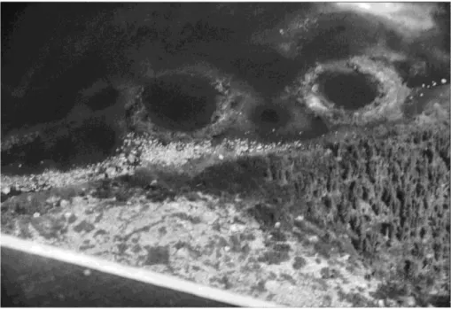
As soon as 1984 (Pissart and Gangloff, 1984), we were convinced that the Hautes Fagnes “viviers” were remnants of mineral palsas, but we had not observed closed and ramparted depressions similar to the fossil forms of Belgium. In 1998, however, during a trip in Hudsony, directed by M. Allard (Laval University) after the IPA Congress of Yellowknife, we were lucky enough as to observe, along a lakeshore, several ramparted and circular depressions, absolutely identical to the fossil features we described in Belgium (Figs. 13, 14 and 15). As these depressions were under the lake level, the ice that formerly constituted the mounds had completely melted out. We have been since then firmly convinced that we then finally observed the present-day equivalent of the fossil forms of the Hautes Fagnes.
Fig. 13. Aerial photograph of lithalsa remnants at a lakeshore, close to Professor Serge Payette’s camp, near the Boniface River, subarctic Quebec.
Fig. 14. Surface profile of lithalsa remnant at the same site in Fig. 13.
None of the objections linked to the pingo hypothesis remains if the Hautes Fagnes depressions are considered as lithalsa remnants. The conditions linked to the peculiar mechanisms of injection ice formation are not required for segregation ice formation: the only required condition is the presence of silty material. On the Hautes Fagnes Plateau, the favourable formations are met in the loess layer. Such an extraordinary density of mounds would have never been observed as far as pingos were concerned, but is common in lithalsa fields, where the mounds are numerous and close to one another (Fig. 16). And finally, we will demonstrate below
that the climatic conditions on the Hautes Fagnes Plateau during the Younger Dryas were similar to the conditions prevailing in the areas where lithalsas are located nowadays.
Fig. 15. Aerial view of a lithalsa remnant and of a melting lithalsa at a lakeshore, between Kuujjuaraapik and the Boniface River, subarctic Quebec.
Fig. 16. Aerial view of part of a lithalsa field between Kuujjuaraapik and the Boniface River, subarctic Quebec. In the centre, a melting form leaves behind a pronounced rampart.
6. Present-day lithalsas: characteristic aspects and climatic
conditions needed
Lithalsas and palsas have exactly the same appearance, but lithalsas have no peat cover. They seldom appear alone; generally they form mound fields where they are close to each other (Fig. 16). Their limits are often irregular, especially on lithalsic plateaux. Such plateaux are similar to palsic plateaux, i.e., areas of various extent whose surface has been uniformly heaved by segregation ice (Fig. 17).
Fig. 17. Aerial view of the lithalsic plateau located along the sea and studied by Allard et al. (1996).
Many descriptions of the external look of lithalsas are available, but observations of their internal composition are rather rare. Allard et al. (1996) have realized many diggings on the 5.6-m-thick lithalsic plateau (Fig. 17) developed along the Hudson Bay in silts which have recently emerged because of isostatic rebound.
Fig. 18 presents a section through this lithalsic plateau. When the sequence is complete and not altered by the melting of the upper part, four horizons can be distinguished: Layer 1, superficial, corresponds to the active layer, freezing and melting every year. Its thickness is 0.80 m. Layer 2, immediately under the active layer, is 1 m thick and its ice content is very high (50% to 80% in volume). This ice is aggradational ice, accumulating over the permafrost table, as it will be explained below. Layer 3 has a poor ice content (10% to 30% in volume) and progressively evolves into layer 4, where the ice content is as important as in layer 2 (50% to 80% in volume). The segregation ice, which is responsible for most of the upheaval of the lithalsic plateau, is found in this layer. The thickness of the ice lenses, and the distance between them, increases with depth. The thickest ice layer (20 cm) has been observed near the permafrost base, at a depth of 15 m.
Fig. 18. Ice distribution in the lithalsic plateau shown in Fig. 17, after Allard et al. (1996). Four parts are distinguished within the permafrost, i.e., from the mound top: (I) active layer, freezing and thawing every year; (II) aggradation ice layer, containing a large quantity of ice (50 to 80% in volume); (III) an ice-poor layer (10 to 30% in volume); (IV) a deeper zone where the ice content in volume is between 50% and 80% and where the ice lense thickness increases with depth. Contrary to the interpretation from Allard, we do not think that such ice lenses extend through the whole mound, but rather that these lenses are discontinuous.
This description by Allard et al. (1996) is the first to identify as aggradational ice the ice of the ice-rich layer lying immediately under the active layer. Such an enrichment of ice had already been observed at the top of palsas (Ahman, 1976; Dever et al., 1984; Seppälä, 1988; Fortier et al., 1991; Harris, 1993) but its formation process and its contribution to palsas upheaval had never been underlined. In the peculiar example we invoke, this kind of ice is responsible for 15% of the upheaval of the lithalsic plateau. In the eventuality of permafrost warming, the very first ice to melt would of course be this ice-rich layer lying right under the active layer. This ice layer is locally missing on the right part of Fig. 18, where thermokarstic phenomena have already occurred.
Aggradational ice forms essentially at the beginning of the winter, when the active layer gets frozen. Two freezing fronts appear at this moment. The first one, following the atmospheric cooling, quickly goes down from the surface. The second one moves upwards from the permafrost table, by conduction from the permafrost.
In this part of the active layer, which is always very wet, the freezing front advances very slowly. In the case of a suitable granulometry, it induces a segregation ice lens heaving all the active layer, without changing its thickness. It will last as long as the active layer does not get any
thicker. This process increasing the ice content in the upper part of the permafrost has been observed not only in palsas and lithalsas, and discussed by several authors, among whom is Burn (1988). Besides the process described before, Burn stresses that, under 0 °C, water migrates towards colder places; this process is more efficient than gravity in less permeable parts (because partly frozen) of the permafrost.
As in palsas, the thickness of the snow cover is a fundamental factor in lithalsa development. As soon as the mounds appear, deflation probably blows the snow off their tops, and, doing so, helps the frost penetration, as it was described by Seppälä (1994) for palsas.
Lithalsas have only been reported from Canada (subarctic Quebec) and Lapland, but from nowhere else in the world. The map of Fig. 19 locates areas where lithalsas have been observed, according to a letter from Lagarec, University of Ottawa, in 1986. There are especially many lithalsas along Hudson Bay, where the continental isostatic rebound has exposed marine silts. Everywhere lithalsas are found, palsas are found, too. Four meteorological stations are located in the lithalsa zone and two are just out of it, one to the north and one to the south (Fig. 19). Table 1 presents published climatic data for these six stations. According to these data, lithalsas are localized in areas where the mean annual air temperature is −4.3 to −5.8 °C and the average temperature of the warmest month between +9.5 and +10.7 °C. No lithalsa is found where the mean annual air temperature reaches −6.7 °C (Inukjuak) or −4 °C (Schefferville).
Fig. 19. Location of the Quebec subarctic zone where lithalsas exist, according to the indications provided by Lagarec, from the University of Ottawa, in a personal letter (1986). Distribution of plant associations is from Lavoie and Payette (1994). The meteorological stations mentioned in the text are plotted on this figure, with the research station of S. Payette on the Boniface River, close to where Figs. 13 and 14 pictures were taken. From Pissart (2000), reproduced with permission.
The best summary about the climatic conditions required for lithalsa formation has been published by Allard et al. (1986). They point out that lithalsas exist only in environments where the mean temperature of the warmest month is less than +10 °C and the mean temperature of
the coldest month less than −5 °C. Unfortunately, they did not present a map of the areas that would be prone to lithalsa formation.
Table 1. Temperature in the lithalsa zone of Northern Québec and in bordering regions without lithalsas.
Mean temperature of the warmest month (°C)
Mean annual temperature (°C) Mean temperature of the coldest month (°C)
Inukjuak (Allard and Seguin, 1987) (outside the lithalsa zone, in the continuous permafrost area)
+8.5 −6.7 −25.2
Kangiqsualujjuaq (An and Allard, 1995)
+9.5 −5.8 −22.0
Kuujjuaq (Worsley et al., 1995)
+11.5 −6.0 −24.0
Poste de la Baleine, Kuujjuaraapk (Allard and Seguin, 1987)
+10.7 −4.3 −23.0
Schefferville (Payette and Filion, 1993) (outside the lithalsa zone)
−4.0
In Lapland, the climatic conditions favourable to lithalsa formation are more difficult to define (Table 2). The few described lithalsas are found at higher altitudes and meteorological stations are not very close to each other. Therefore, climatic conditions are only estimated there, but not measured. These data indicate that the area prone to lithalsa formation would be characterized by a mean annual air temperature of about −3 to −4.5 °C and a mean temperature of the warmest month of less than +9 °C. These conditions are thus very close to the ones observed in Quebec.
At last, a group of similar cryogenic mounds has been described by Matthews et al. (1997) in southern Norway, at a latitude of 62°21′N and a longitude of 9°18′E. The features seem to have appeared under a thin peat layer (less than 20 cm thick), which was later eroded, and to have evolved as mineral mounds, looking like lithalsas. The presence of peat at the early stages of the formation process impedes us to put those forms in the same category as typical lithalsas. According to data from meteorological stations located several tens of kilometers away and at 450 m lower elevation, this area would have been characterized by a mean annual air temperature of −2.7 °C and a mean temperature of +7 °C in July.
As a conclusion, the climatic conditions required for the formation and development of lithalsa are quite precise, as indicated by the data collected in the areas of Hudsony and Lapland where such mounds exist. Lithalsas, like palsas, form only in the discontinuous permafrost zone. Ice accumulation in depth is required for their formation; if permafrost is already developed at the spot, their formation will be inhibited because of the lack of water supply in depth. On the other hand, when the mound grows, deformation of the frozen soil is much more difficult than the upheaval of a permafrost island; the capillary force that feeds the lithalsas segregation ice is perhaps insufficient to cause an upheaval that would deform the frozen layers. However,
lithalsas formation requires the coldest conditions of discontinuous permafrost, as shown by one of Seppälä’s (1988) diagram. This diagram indicates that a mean annual AIR temperature of −6 °C is necessary for the formation of palsas without any peat cover (i.e., lithalsas). Lithalsas can thus only form in the coldest discontinuous permafrost areas, i.e., along the border of the continuous permafrost zone.
Table 2. Temperature in Lappish regions where cryogenic mounds are likely to be lithalsas.
Mean temperature of the warmest month (°C)
Mean annual temperature (°C) Mean temperature of the coldest month (°C)
Corgossjokka, Norway, 70°00′N, 26°00′E, altitude 580 m (Meier, 1987) No precise temperature data available, only extreme data
+9 to +12 −1 to −3 −13 to −17
Taavavuoma, Sweden, 68°30′N, 20°45′E, altitude 600 m (Wramner, 1973)
−3 to −4
Sweden, 69°00′N, 21°30′E, altitude 700–800 m (Lagerbach and Rohde, 1985)
−3.5 (1951–1980)
Rakaslako, Sweden, 68°25′N, 18°30′E, altitude 850–1000 m (Åkerman and Malmström, 1986)
850 m: +8.3 −3.9 −14.6
950 m: +7.2 −4.4 −15.1
A second climatic condition governs the existence of lithalsas: the mean temperature of the warmest month. As already stated, this parameter cannot get higher than +10 °C, otherwise lithalsas would begin melting, because, unlike palsas, they are not protected by an insulating peat cover. Lithalsas are therefore only found in regions where summers are cool.
Taking into account the information we have gathered, the permafrost map of Brown et al. (1997) can be used to determine where lithalsas can exist in the world (Pissart, in press). This map indeed provides indirectly the two climatic elements required for pointing out the favourable areas: (1) the limit between continuous and discontinuous permafrost areas, and (2) the tree line, considered as similar to the 10 °C isotherm of the warmest month. The regions where lithalsas can appear are the areas where the tree line is close to the limit of continuous permafrost. From east to west, these areas are: subarctic Quebec, an area north of the Great Slave Lake (Canada), the westernmost part of Alaska, Sakhalin, the part of Siberia close to the Okhotsk Sea, areas on both sides of the Ural Range and, at last, Lapland. A very continental climate is not suitable, like for example the climate prevailing in most of Siberia, where the tree line winds in the middle of the continuous permafrost area.
7. Climatic conditions in western Europe, during the
Younger Dryas
Isarin’s palaeoclimatological reconstructions (Isarin, 1997a,b; Isarin and Bohncke, 1999) have defined the climatic conditions in western Europe during the Younger Dryas, and in particular two useful parameters: the mean annual temperature and the mean temperature of the warmest month.
Summer temperatures have been derived from the relationship that exists between plants distribution and temperatures of the warmest month, as shown in Iversen’s (1944) thesis. While growing, plants need indeed a specific minimum temperature to bloom and breed. Thereby, they are indicators of summer temperature. This principle explains why the tree line follows, more or less, the +10 °C isotherm of the warmest month. Pollen or macrofossils of a definite species found in a peat bog can be used as a summer temperature indicator at a specific time and a specific place.
Isarin’s results (Isarin, 1997a; Isarin and Bohncke, 1999) are highly reliable, as he gathered 140 pollen diagrams and macrofossil observations from whole western Europe, for reconstructing summer temperatures. Fig. 20 gives the assessed distribution of the minimum mean temperature in July during the first part of the Younger Dryas. Temperatures are calibrated to sea-level equivalents, using a uniform temperature gradient of 0.6 °C per 100 m of elevation. As the highest areas of Belgium reach about 700 m, the temperature there should be 4.2 °C colder than plotted on this map.
Fig. 20. Map of July isotherms during the first part of the Younger Dryas, from Isarin (1997a, p. 69). From Isarin and Bohncke (1999), reproduced with permission from the Academic Press.
In the second part of his study, Isarin (1997a,b) reconstructed the mean annual temperature. The criterion used here is the distribution of periglacial features: frost cracks, ice wedges,
cryoturbations and periglacial mounds. The observations taken into account came from all around in western Europe and allowed Isarin to come up with a map showing the limits of discontinuous permafrost and of continuous permafrost at sea-level. These data have then been converted into mean annual temperatures, still at sea-level and according to the same temperature gradient of 0.6 °C per 100 m (Fig. 21).
Fig. 21. Isotherms of the mean annual temperatures and of the mean temperatures of the coldest month (in italic) at sea level during the Younger Dryas. From Isarin (1997b), reproduced with permission.
The climatic data obtained by Isarin for the Hautes Fagnes Plateau during the first part of the Younger Dryas are remarkably similar to those prevailing nowadays in the area of subarctic Quebec where lithalsas are found.
By applying the correcting factor promoted by Isarin (1997b) (0.6 °C per 100 m), to the area of the Hautes Fagnes Plateau where lithalsas remnants were found (i.e., at elevations ranging from 500 to 700 m a.s.l.), the mean temperature of the warmest month would have been there between + 9.3 and +10.5 °C. In the lithalsa zone of Quebec, this temperature values range between +9.5 and +10.7 °C. Mean annual temperatures are very similar, too: between −5.0 and −6.2 °C in the same Belgian region, and between −4.3 and −5.8 °C in the Canadian region. Although such climatic reconstructions have always to be considered with greatest caution, these values similarity is outstanding.
The temperature of the coldest month can be inferred from the former data. As the mean monthly temperatures over a year period follow a sine curve, the values of the mean annual temperature and the mean summer temperature enable the calculation of the mean temperature for the coldest month. On the summit of the Hautes Fagnes Plateau, at 700 m a.s.l., this value would have been around −21.7 °C when the lithalsas formed. Nowadays (over the period 1960– 1990), according to Van Diepenbeek (Royal Institute of Meteorology, Brussels), mean temperature values at Baraque Michel are: January −1.7 °C, July +14 °C, year +6.2 °C. During the Younger Dryas, the temperature for the coldest month was 20 °C lower than now, July was 4.7 °C colder and the entire year had an average temperature 12.4 °C lower than nowadays.
8. Lithalsa remnants known in the world
8.1. INTRODUCTION
After Maarleveld and Van den Toorn (1955) had for the first time described pingo traces in the Netherlands, many papers have been dedicated to depressions regarded as remnants of cryogenic mounds. At the beginning, all of them were interpreted as traces of pingos, since lithalsas have only been known since 1972 (Wramner, 1972). We are quoting below most of the papers that have interpreted enclosed depressions by the melting of cryogenic mounds. We however want to distinguish the depressions surrounded by a rampart and the depressions without any rampart, as the periglacial origin of the second ones is not clearly established. In other words, the presence of more or less pronounced ramparts is the main criterion that allows asserting some likeness between these features and the Hautes Fagnes “viviers”. Besides, only grouped features will be considered as identical to the “viviers”. Finally, only the features that appeared during the Younger Dryas will be taken into consideration for a palaeoclimatological reconstruction.
8.2. IN THE BRITISH ISLES: DEPRESSIONS SURROUNDED BY A RAMPART;
PROBABLY TRACES OF LITHALSAS
Traces of cryogenic mounds have aroused much interest after I described traces of depressions surrounded by a rampart in Wales in 1963, for the first time in the British Isles (Pissart, 1963). These were quite similar to the Hautes Fagnes “viviers”, which I interpreted at that time as remnants of pingos. The depressions observed in Wales were identical to the “viviers” in all respects: by their dimensions, by their rampart and also by their age, since their filling had begun during the Preboreal (Trotman, 1963). Similar features have been described later in other parts of Wales by Watson (1971, 1972, 1977) and by Watson and Watson (1972, 1974), then in Ireland by Mitchell (1971, 1973), Coxon (1986) and Coxon and O’Callaghan (1987). Fig. 22 (from Coxon and O’Callaghan, 1987) shows the Irish sites where these features, considered as pingo traces, had been observed. All these depressions may be identical to the “viviers”, but this is certain only for the features that have been described in detail, i.e., the ones numbered in Fig. 22.
In southeastern Ireland, near Camaross, 9 km west–north–west of Wexford, the morphology described by Mitchell (1971, 1973) is absolutely similar to the Belgian one. The features density, as shown on Mitchell’s (1973) maps and photographs, is the same as in the Hautes Fagnes. The fillings of all the features known in Ireland are immediately posterior to the Younger Dryas (Mitchell, 1973; P. Coxon, personal communication, August, 1 998). These depressions surrounded by a rampart form groups at altitudes ranging from 20 to 150 m a.s.l. No relationship with substratum has been observed, but some diamicton (often solifluction deposits), 1–1.5 m thick, is present on every site.
Fig. 22. Location of “pingo remnants” in Ireland, after Coxon and O’Callaghan (1987). Identifying lithalsa remnants is possible thanks to the descriptions of the numbered sites, especially for the zone 2 detailed by Mitchell (1973). In dots, the limit of the last glaciation. From Coxon and O’Callaghan (1987, Fig. 18.1, p. 196), reproduced with permission from the Cambridge University Press.
Bryant and Carpenter (1987) have also summarized what was known about the ramparted thermokarstic depressions observed in the British Isles. The map of Fig. 23 (Ballantyne and Harris, 1994) presents their results, plus the locations of the possible pingo remnants described by Hutchinson. The sites where the features look like the Hautes Fagnes “viviers” are: Llangurig (Wales, elevation: 330 m a.s.l., described by Pissart, 1963), Cledlyn Valley (Wales, elevation: 330 m a.s.l., Watson and Watson, 1972, Fig. 24), and Cletwr Valley (Wales, elevation: 200–330 m a.s.l., Watson and Watson, 1972, Fig. 25). The age of those depressions is uncertain, according to Ballantyne and Harris (1993). However, 14C age determinations and pollen analyses indicate
that they appeared during the Younger Dryas, as concluded by Handa and Moore (1976). They specifically state that pollen analysis and 14C age determination of the fillings of 3 pingos studied
in the Cledlyn and Cletwr valleys reveal that they were formed during the cold post-interstage Goldwin’s zone III phase. This precision fits the conclusion of Trotman (1963) about a feature in Llangurig.
Fig. 23. Location of the depressions induced by ground ice melting in Great Britain, after Ballantyne and Harris (1994) with modifications. (1) Limit of the last glaciation maximum extent; (2) Limit of the Pleistocene glaciation maximum extent; (3) Open system pingo remnants and cryogenic mound remnants, as identified by the surface topography; (4) Possible open system pingo remnants and cryogenic mound remnants; (5) Possible sites of closed system pingos; (6) Lithalsa remnants. Only the star-marked sites, added to the original figure of Ballantyne and Harris, are undoubtedly lithalsa scars similar to the Hautes Fagnes “viviers” formed during the Younger Dryas (Pissart, 1963; Watson and Watson, 1972, 1974). The star in East Anglia indicates a similar feature dating back to the end of the Pleniglacial (Sparks et al., 1972). We do not put under scrutiny the other sites, but the description brought back from the Isle of Man
by Watson (1971) does not correspond to lithalsa scars. From Ballantyne and Harris (1994, Fig. 5.14, p. 75), reproduced with permission from the Cambridge University Press.
Ballantyne and Harris (1994) also mention depressions surrounded by a ramp art near Brent Tor (Dartmoor). These were reported by Miller in an unpublished thesis, but we do not have enough information about them for establishing whether these are similar to the features previously described.
The depressions described by Watson (1971) on the Isle of Man as pingo remnants, are reported by Ballantyne and Harris (1994) as “ramparted”, although Watson mentioned a “complete absence of ramparts”. Those forms are thus not similar to the “viviers”.
The numerous forms of Cardiganshire (Watson, 1972) have not been described at all and are not mentioned in other publications; it prompts us to be prudent, particularly because Watson described at that same period the features of the Isle of Man, which are different. The same lack of detailed description impedes us to accept the likeness of “viviers” and features developed in the London clay and reported by Hutchinson (1980, 1991) as pingo remnants. We do not intend here to judge the origin of the described morphologies, but just to indicate whether they are identical or not with the Hautes Fagnes “viviers”.
Fig. 24. Lithalsa remnants of the Cledlyn valley (Wales) studied by Watson (1971) and interpreted as pingo remnants dating back to the Younger Dryas.
On the other hand, we must stress the likeness of the features described by Sparks et al. (1972) in Eastern England (at elevations lower than 30 m a.s.l.), with the ones from the Hautes Fagnes and from Wales. The authors prudently avoided calling them pingo remnants, emphasising that there are too many depressions per unit of area for the pingo hypothesis to be acceptable. They explained their formation by ground ice melting without proposing any present-day analogue from the Arctic. The differences with the Hautes Fagnes “viviers” are that these English ramparted depressions are constituted of chalk fragments and sand, and that this feature developed at the base of a chalk outcrop, in an area where springs and water risings are found. Two periods have been reckoned for the development of these depressions. The first and main one might have occurred at the end of the Pleniglacial, thus clearly before the Younger Dryas. The second one, less important, might have taken place at the end of the Younger Dryas. We thus understand that the peculiar morphology that catches our attention in that paper appeared a
long time before the Younger Dryas and cannot be considered as similar to the “viviers” for a palaeoclimatological reconstruction. However, this question would be worth getting confirmed.
Fig. 25. Lithalsa remnants of Cletwr valley (Wales) interpreted as pingo remnants dating back to the Younger Dryas (Watson and Watson, 1974).
In Surrey, south of London, Carpenter and Woodcock (1981) have described an isolated depression surrounded by a low rampart (maximum 1 m). It developed in sands and its filling (according to pollen analysis) dates back at least to the Younger Dryas, but the authors are not able to say when the depression actually formed. That isolated feature developed in sands is not comparable with the “viviers” and might be, according to these authors, the remnant of an open system pingo.
An excellent summary is presented in the book of Ballantyne and Harris (1994, pp. 65–83) (Fig. 23). They review the whole range of morphologies that are believed to form because of ground ice melting, but they do not classify them according to their age. However, they group the features that are identical with the Hautes Fagnes “viviers” on two figures (Fig. 5-17 and 5-18 in Ballantyne and Harris, 1994). In that chapter conclusion, the authors support the pingo hypothesis and do not take into consideration the fossil features density in the field. This parameter is a major objection to that hypothesis.
Gurney (1995) presented a reassesssment of the relict pleistocene pingos of West Wales and proposed to consider these features as the remnants of mineral palsas.
8.3. IN LAPLAND
As far as we know, Rapp and Rudberg (1960) have been the first ones to report the existence of ramparted lakes. These features near Abisko, in Sweden, looked “like the remains of small pingos.” This site was later studied by Åkerman and Malmström (1986), who could prove that some of these features still contained ice.
Svensson (1964), after a description of depressions observed in the northernmost part of Norway, writes: “In the morphological details, there is great conformity between the form examined in this paper and the viviers of Hautes Fagnes.” This morphology of depressions surrounded by 7 m high ramparts, but also of crisscrossed ridges, is located south of the Laksefjord, whose outlet lies 50 km southeast of the North Cape. Four sites between this fjord and the Tana River are described; they are situated beyond tree line on the swiftly undulating surface (250–600 m a.s.l.) of Finmark. The author could not get into digging profiles, and thus restricts himself to a morphological description. The aerial photograph provided in this paper displays a topography which is identical with the complex forms of the Hautes Fagnes. Svensson realizes how difficult it would be to interpret these features as pingo remnants but, as there is no other likely solution, he ends up supporting this hypothesis. This morphology is assumed to be fossil, as no formation or degradation processes have been noticed.
Svensson (1969) describes ramparted lakes in the same Norwegian region (70°N, 26°E), at elevations ranging from 400 to 600 m a.s.l. One of these features is subsiding because of ground ice melting. The author reports fossil features at lower altitudes, too. According to him, these prove the occurrence of a colder episode during the Holocene. Because of the lack of climatic data, we did not take this research into account when discussing the conditions of lithalsas formation.
Seppälä (1972) describes a morphology quite similar to the Hautes Fagnes “viviers” in northern Finland (69°05′N, 26°37′E), in an area currently free of permafrost (Fig. 26). The ramparts, very close to one another and muddled up the way they appear in the Hautes Fagnes, are 0.5–4.5 m high. These features were interpreted as pingos remnants; this conclusion was normal at a time when lithalsas were still unknown. This morphology developed in a sand-rich till containing debris and blocks. The author stresses their likeness with the Hautes Fagnes “viviers” and the depressions of Llangurig in Wales, and writes: “Morphologically very similar ridge forms have been described from western Europe (Pissart, 1963)”. The age of these features is not precisely known, but 14C age determinations indicated that deglaciation in that area came to an end about
9800 years ago. Like Svensson (1969), Seppälä concludes that the existence of these forms proves that deglaciation was followed by a period with colder climatic conditions than today.
Fig. 26. In Lapland (69°05′N, 26°37′E), morphology identical to the Hautes Fagnes “viviers”. These features were described as pingo remnants, but are certainly lithalsa remnants (Seppälä, 1972). (1) Till deposits ridge; (2) pond; (3) peat bog; (4) flow direction; (5) limit of a Tardiglacial drainage channel.
These papers show that fossil and current features do exist, close by, in a same area of Lapland. The fossil features and the present-day lithalsas, mentioned before in Table 2, are located within a distance of 120 km. As stressed by the quoted authors, it is not necessary to refer to major climatic changes in order to explain the presence of lithalsa remnants 100 or 200 m lower than the altitude at which current lithalsas are observed (580–1000 m).
8.4. IN THE NETHERLANDS: PROBABLY SOME TRUE PINGO REMNANTS, BUT
ALSO POSSIBLY A FEW LITHALSA REMNANTS
8.4.1. PROBABLE PINGO
Maarleveld and Van der Toorn (1955) published the first paper describing pingo remnants in Europe. It was followed by many other publications: Nossin, 1961; De Gans, 1976, 1981, 1988; Cleveringa et al., 1977; De Gans et al., 1984; Paris et al., 1979; Van der Meulen, 1988.
The published studies of these depressions all agree: ramparts existed in the past, but have been degraded by subsequent processes, chiefly aeolian. The features have larger dimensions than in the Hautes Fagnes, and they are regularly shaped (oval or circular). Age determinations indicate that these cryogenic mounds might have appeared during the Pleniglacial (except for Maarleveld and van der Toorn, 1955, and Nossin, 1961, who point out depressions of the Younger Dryas, but this age has not been confirmed later). These features are clearly not similar to the Hautes Fagnes “viviers”. The Dutch authors suggest that these are remnants of closed system pingos, that perhaps developed when deep permafrost was settling in, and this hypothesis seems quite
convincing. These pingos would not have been related to lakes, but could have appeared at the same time as permafrost, just like some pingos from Prince Patrick Island that we described (Pissart, 1967).
8.4.2. PROBABLE LITHALSAS REMNANTS
Kasse and Bohncke (1992) described very numerous depressions in the “Groote Peel” Natural Area, in the southern Netherlands; their length is up to 90 m and their depth up to 3 m. A low rampart (0.5–1 m) surrounds some of them. Joosten and Bakker (1987), Van den Munckhof (1988) and Joosten (1988) have considered them as possible pingo remnants. The aerial photograph published by Kasse and Bohncke (1992) displays as many forms per unit of area as observed in the Hautes Fagnes. Investigating the filling of two carefully selected basins enabled to distinguish a shallow basin (1 m) induced by wind deflation and a deeper one (3 m) which could be the remnant of some cryogenic mound formed by segregation ice. Pollen analyses indicate that the filling of the latter depression began during the Older Dryas. The authors estimate that the melting of the ice core ended early in the Bölling. In the field, this morphology is hardly visible. The aerial view shows a feature density such that they could not be pingo remnants. These features are the only ones that look like the “viviers” in the Netherlands. However, these are older than the Younger Dryas, since ground ice is thought to have formed during the Pleniglacial.
8.5. IN FRANCE AND GERMANY: FEATURES WITHOUT ANY RAMPART,
DIFFERENT FROM THE “VIVIERS”
Cailleux (1956, 1960a,b) suggested that some closed depressions from the Paris area should be considered as pingo remnants. We studied these forms (Pissart, 1958), but found no likeness to the Hautes Fagnes “viviers”. Boyé (1957, 1958) referred to the same hypothesis about some depressions from the Landes, but no rampart was ever discovered there and these features still remain enigmatic. Let us also mention that Rousset (1964) and Bout (1986) have interpreted as “periglacial” small lakes formed over basalt in the Massif Central, but these closed depressions have no rampart neither.
In Germany, several studies have proposed to interpret some depressions as pingo remnants. The first one of these studies (Mückenhausen, 1960) was dedicated to elongated “viviers”, lying right next to the Belgian border and identical the Belgian “viviers”. This paper—which acknowledged my 1956 pingo hypothesis—stated that the elongated features of the Hautes Fagnes were formed by a gradual alimentation at the top of the ice core.
Picard (1961) described four isolated depressions, 60 m in diameter, near Husum, on the west coast of Schleswig–Holstein, about 45 km away from the Danish border. He interpreted them as pingo remnants, too.
A voluminous publication by Wiegand (1965) describes numerous depressions interpreted one again as pingo remnants. Although some ramparts are locally reported, no picture and no cross-section display a morphology identical to the one of the Hautes Fagnes “viviers”. Mückenhausen et al. (1976) described closed depressions on Rhine terraces, but their descriptions do not mention ramparts, and they thus do not look like the Belgian “viviers”.
8.6. IN POLAND AND NORTH AMERICA: DIFFERENT DEPRESSIONS
In Poland, Dylik (1964) observed closed depressions near Łódź. The structure of one of these was assessed by numerous borings. This basin developed in sands and fluvioglacial gravels dates back to the penultimate glaciation, since Eemian peat was present in its filling. No rampart was seen, nor any structure that would result from material slipping down a mound side. This feature, interpreted as a pingo remnant, is different from the Hautes Fagnes “viviers”.
Very recently, a depression located in the furthest northeast part of Poland has been interpreted as a former pingo (Rutkowski et al., 1998). It is an impressive depression: its diameter is 140 m and its sand and gravel rampart is 10–18 m high! The authors consider it as the largest and best-preserved pingo remnant in Europe. Although it is not comparable at all with the “viviers”, its complete study is waited for with the greatest interest.
In America, very few depressions have been interpreted as possible pingo remnants. The best-known forms are the pingo remnants described by Flemal in Illinois (Flemal et al., 1973; Flemal, 1976). These features are more than 500 over an area of about 300 km2. They are distributed on
a low till plain characterized by thick glacial deposits. Their shape is round or elliptical. Some are ramparted. Their average diameter is several tens of meters, although several are as large as 400 m in diameter. The minimum height of the ramparts is less than 1 m, the maximum more than 5 m. These features are often grouped and sometimes overlap other ones. They are filled with lacustrine sediments up to 7 m thick. The study of this filling indicated a Wisconsinian age. Ring-shaped depressions around these features have been explained as the result of permafrost ice melting around former pingos. Such ringshaped depressions are not found around lithalsa remnants; and could actually not form around lithalsas, which constitute permafrost islands. We therefore believe we are dealing here with a different morphology, which has nothing to do with the Hautes Fagnes “viviers”.
We also have to mention that Bik (1969) proposed to consider some prairie mounds in Alberta, Canada, as possible remnants of pingos. These features are very well depicted in this paper, but present no common point with the Belgian “viviers”.
Besides, Professor P. Gangloff and me saw in 1993 in Pennsylvania some depressions which had been described as “Pleistocene pingo scars” (Marsh, 1987). They were not similar to the “viviers” and Marsh later changed his mind and reinterpreted them as formed by wind action (Marsh, 1992, 1998).
9. Distribution of Younger Dryas lithalsa remnants and
Isarin’s palaeoclimatological data
All these publications we have quoted indicate that lithalsa remnants identical to the Hautes Fagnes “viviers” are rare. To be similar to the Belgian features, depressions must be surrounded by a rampart and gathered in close groups. They must also be of the same age, i.e., date back to the Younger Dryas.
The following features would thus be identical: the Hautes Fagnes “viviers” between 500 and 700 m a.s.l., the Welsh depressions between 200 and 330 m a.s.l. (Pissart, 1963; Watson, 1971; Watson and Watson, 1972, 1974) and southern Ireland features between 20 and 150 m a.s.l. (Mitchell, 1971, 1973; Coxon, 1986; Coxon and O’Callaghan, 1987; Warren, 1987). In Norfolk (Sparks et al., 1972) and in the Netherlands (Kasse and Bohncke, 1992), some features have the same look, but a different age, as they are older.
As previously mentioned, the subarctic Quebec lithalsas form in the discontinuous permafrost zone, where the mean annual air temperature varies between −4.3 and −6 °C, and where summers are cool, as mean temperature in July varies between +9.5 and +11.5 °C. Such precise data are unfortunately not available for the Lapland features: in the area where lithalsas exist, estimated temperatures are −3.9 °C (as an annual average) and +8.3 °C (for the warmest month). Therefore, we will assume from now on that lithalsas can form in areas where the mean annual air temperature ranges from −4 to −6 °C, and the temperature of the warmest month from +9 to +11.5 °C.
Figs. 27, 28 and 29 show, according to Isarin’s data (Isarin, 1997a,b; Isarin and Bohncke, 1999), where such conditions were met during the Younger Dryas, at different elevation levels: at sea-level, at 250 m a.s.l. and at 500 m a.s.l. On each of these figures, for each of these three elevation levels, we indicate the zone where the mean annual temperature (MAT) value is between −4 and −6 °C and the zone where the temperature of the warmest month is between +9 and +11.5 °C. Only where these two zones overlap, i.e., where these two conditions are met, can lithalsas appear and grow. At sea-level (Fig. 27), the only favourable region is southern Ireland, where Younger Dryas lithalsa remnants have indeed been observed.
At 250 m a.s.l. (Fig. 28), the area prone to lithalsa formation covers southern Wales, England, the northern part of Belgium, the southern part of Netherlands, and extends into Germany. But, lithalsa remnants have actually been found exclusively in Wales, which is, among all the regions quoted above, the only one where elevation exceeds 250 m a.s.l.
Fig. 27. According to Isarin’s (1997b) data, location at sea level of the Western European areas that were prone to lithalsa formation during the Younger Dryas. Only southern Ireland fulfilled the conditions, with a mean annual temperature (MAT) between −4.0 and −6.0 °C and a mean July temperature (MJT) lower than +11.5 °C. From Pissart (2000), reproduced with permission.