HAL Id: pastel-00766986
https://pastel.archives-ouvertes.fr/pastel-00766986
Submitted on 19 Dec 2012HAL is a multi-disciplinary open access archive for the deposit and dissemination of sci-entific research documents, whether they are pub-lished or not. The documents may come from teaching and research institutions in France or abroad, or from public or private research centers.
L’archive ouverte pluridisciplinaire HAL, est destinée au dépôt et à la diffusion de documents scientifiques de niveau recherche, publiés ou non, émanant des établissements d’enseignement et de recherche français ou étrangers, des laboratoires publics ou privés.
Cooperative perception : Application in the context of
outdoor intelligent vehicle systems
Hao Li
To cite this version:
Hao Li. Cooperative perception : Application in the context of outdoor intelligent vehicle systems. Other. Ecole Nationale Supérieure des Mines de Paris, 2012. English. �NNT : 2012ENMP0034�. �pastel-00766986�
N°: 2009 ENAM XXXX
École doctorale n° 432 : Sciences des Métiers de l’Ingénieur
présentée et soutenue publiquement par
Hao LI
le 21 septembre 2012Cooperative Perception:
Application in the Context of Outdoor Intelligent Vehicle Systems
(Perception Coopérative : Application au Contexte des Systèmes de Véhicules Intelligents à l’Extérieur)
Doctorat ParisTech
T H È S E
pour obtenir le grade de docteur délivré par
l’École Nationale Supérieure des Mines de Paris
Spécialité “Informatique temps réel, Robotique, Automatique”
Directeur de thèse : Fawzi NASHASHIBI
T
H
È
S
E
JuryM. Roland CHAPUIS, Professeur Polytech Clermont-Ferrand Rapporteur
M. Philippe BONNIFAIT Professeur UTC Compiegne Rapporteur
M. Christian LAUGIER DR1/Thèse d’Etat INRIA Rhône-Alpes Président
M. Bruno STEUX Docteur Mines Paristech Examinateur
M. Michel PARENT Docteur INRIA Paris-Rocquencourt Examinateur
ABSTRACT
The research theme of this dissertation is the multiple-vehicles cooperative perception (or cooperative perception) applied in the context of intelligent vehicle systems. The general methodology of the presented works in this dissertation is to realize multiple-intelligent vehicles cooperative perception, which aims at providing better vehicle perception result compared with single vehicle perception (or non-cooperative
perception). Instead of focusing our research works on the absolute performance of
cooperative perception, we focus on the general mechanisms which enable the realization of cooperative localization and cooperative mapping (and moving objects detection), considering that localization and mapping are two underlying tasks for an intelligent vehicle system. We also exploit the possibility to realize certain augmented reality effect with the help of basic cooperative perception functionalities; we name this kind of practice as cooperative augmented reality. Naturally, the contributions of the presented works consist in three aspects: cooperative localization, cooperative local mapping and moving objects detection, and cooperative augmented reality.
Description
We have used in this work several sorts of sensors, namely GPS-based GNSS, a laser scanner, a camera, and a motion sensor, which have been commonly used for single intelligent vehicle operation. With these sensors, an intelligent vehicle can possess fairly complete perception abilities towards itself and the environment. We have reviewed the Bayesian filter framework that has been commonly used for recursive state estimation; we have also reviewed several recursive estimation methods that are derived from the Bayesian filter framework based on different kinds of approximations. We have discussed in detail the fundamental problems and the state-of-the-art methods concerning the cooperative localization, cooperative local mapping and moving objects detection. Based on these discussions, we propose a general architecture of cooperative localization using split covariance intersection filter (SCIF), an indirect vehicle-to-vehicle relative pose estimation method, and a new method for occupancy grid maps merging to handle the fundamental problems in cooperative localization, and cooperative local mapping and moving objects detection. We finally propose a brand
new idea of cooperative augmented reality which utilizes cooperative perception results to realize a special augmented effect.
We have provided a solution of multi-vehicles cooperative localization. We have reviewed the concept of estimate consistency and the SCIF. We have presented several forms of this filter together with their derivations and an original proof for the fusion consistency of this filter. We have introduced several basic functionalities as the condition for realizing cooperative localization; these functionalities are abstracted from field practice based on their feasibility in reality. We have described a general architecture of cooperative localization using the SCIF; as the architecture is decentralized, we have described from the perspective of an intelligent vehicle how it can evolve its state estimate using its motion measurements, how it can update its state estimate using its own absolute positioning measurements, and how it can update its state estimate with the data shared by neighbouring vehicles. We have presented the indirect vehicle-to-vehicle relative pose estimation strategy.
We have provided a solution of cooperative local mapping and moving objects detection for laser scanner based intelligent vehicles. We have reviewed the method of occupancy grid based single vehicle local SLAM, including how to use laser scanner based range measurements to incrementally update the occupancy grid map estimate according to the inverse measurement model and how to estimate current vehicle local state (pose) with the last estimate of the vehicle local state and occupancy grid map. We have explained the different roles of vehicle local state and vehicle global state; we have described how vehicle local state estimate in SLAM can be used to assist vehicle global state estimation. We have presented the framework for occupancy grid maps fusion and merging by generalizing and formalizing its essential part into an optimization problem. We have proposed a new objective function that measures the consistency degree of maps alignment based on occupancy likelihood. We have adopted the spirit of genetic algorithms and designed a set of concrete procedures to search the optimal maps alignment. We have introduced the scheme of multi-vehicles cooperative moving objects detection based on occupancy grid maps merging; for a complete implementation, we have reviewed two basic moving objects detection methods, namely the consistency-based detection and the moving object map based detection. We have extended the spirit of augmented reality to cooperative perception, forming the concept of cooperative augmented reality in the context of intelligent vehicle systems. We have specified the front-following vehicles scenario to which the proposed idea of cooperative augmented reality is applied. We have reviewed the pinhole camera model and described how to establish spatial relationship between two views (easily
extendable to multi-views case) according to perspective geometry. We have described several coordinates systems i.e. the camera coordinates system, the laser scanner coordinates system, the ground coordinates system, and the vehicle coordinates system that are concerned in an intelligent vehicle; we have introduced a technique of utilizing a 2D laser scanner to assist a mono-camera in estimating the visual perception depth approximately. We have presented how to map the visual perception of a vehicle onto that of another vehicle, abiding by the multi-views perspective geometry described. We have also introduced a new extrinsic calibration method for a camera and a 2D laser scanner, which can reveal all the spatial relationships among the camera’s coordinates system, the laser scanner coordinates system, the ground coordinates system, and the vehicle coordinates system, based only on the popular chessboard calibration practice with few extra measurements.
We have presented the experimental conditions and experimental results concerning cooperative localization, cooperative local mapping and moving objects detection, and cooperative augmented reality. We have presented the results of a simulation based comparative study which demonstrates the advantage of the proposed cooperative localization architecture using the split covariance intersection filter (the SCIFCL approach), especially for intelligent vehicles with heterogeneous absolute positioning ability. A prominent advantage of the SCIFCL method is that it enables good localization results to be naturally spread within a vehicle network in connection while always keeping a reasonable confidence for the state estimate of each vehicle. We have also presented the results of field tests (real-data) on cooperative localization, which lead to similar conclusions as in the simulation based comparative study. We have demonstrated the performance of the proposed occupancy grid maps merging method based on real-data tests. In spite of an intentionally exaggerated initial error range, local occupancy grid maps built by different vehicles can always be merged correctly using the proposed method; besides, the proposed occupancy grid maps merging method has the potential to recover the merging result from a kidnapping situation. We have demonstrated the performance of a proposed method coined as cooperative augmented reality, which realizes a vivid and lifelike effect of ‘seeing’ through the front vehicle for the following vehicle in a front-following vehicles scenario.
RÉSUMÉ
Le thème de recherche de cette thèse est la perception coopérative multi-véhicules appliquée au contexte des systèmes de véhicules intelligents. L’objectif général des travaux présentés dans cette thèse est de réaliser la perception coopérative de plusieurs véhicules (dite « perception coopérative »), visant ainsi à fournir des résultats de perception améliorés par rapport à la perception d’un seul véhicule (ou « perception
non-coopérative »). Au lieu de concentrer nos recherches sur la performance absolue de
la perception coopérative, nous nous concentrons sur les mécanismes généraux qui permettent la réalisation de la localisation coopérative et de la cartographie de l’environnement routier (y compris la détection des objets), considérant que la localisation et la cartographie sont les deux tâches les plus fondamentales pour un système de véhicule intelligent. Nous avons également exploité la possibilité d’explorer les techniques de la réalité augmentée, combinées aux fonctionnalités de perception coopérative. Nous baptisons alors cette approche « réalité augmentée coopérative ». Par conséquent, nous pouvons d’ores et déjà annoncer trois contributions des travaux présentés: la localisation coopérative, la cartographie locale coopérative, et la réalité augmentée coopérative.
Description
Dans nos travaux, nous avons exploité plusieurs sortes de capteurs, à savoir un GNSS à base de GPS, un télémètre laser, une caméra, et des capteurs odométriques. Ces capteurs sont souvent employés pour le fonctionnement d’un véhicule intelligent et, grâce à ceux-ci, un véhicule intelligent est doté d’une capacité de perception assez complète lui permettant d’assurer sa propre localisation et la perception proprement dite de l’environnement.
Afin d’assurer la localisation du véhicule, une architecture à base de filtre Bayésien a été examinée ; celui-ci est couramment utilisé pour l'estimation d'état récursive. Ainsi, un rappel des diverses méthodes d'estimation récursives dérivées de l’architecture de filtre Bayésien est fait. Dans la suite, sont discutés en détail les problèmes fondamentaux et les méthodes existantes dans l'état-of-the-art concernant la localisation et la cartographie locale coopératives. D’après ces réflexions, nous proposons une architecture générale de localisation coopérative en utilisant le « split covariance
intersection filter » (ou SCIF), une méthode de l’estimation indirecte de la localisation relative Véhicule-à-Véhicule. De même, une nouvelle méthode de fusion de grilles d’occupation est présentée et ce, afin de traiter les problèmes fondamentaux en matière de la localisation coopérative et de cartographie locale coopérative.
Nous avons fourni une solution pour la localisation coopérative multi-véhicules. Nous avons rappelé le concept de consistance de l’estimation ainsi que le SCIF. Nous avons présenté plusieurs formes de ce filtre avec leurs dérivations et une preuve originale pour la consistance de la fusion de ce filtre. Nous avons introduit plusieurs fonctionnalités de base comme la condition pour réaliser la localisation coopérative. Nous avons introduit une architecture générale de localisation coopérative en utilisant un SCIF. Puisque l'architecture est décentralisée, nous avons décliné l’approche dans le cadre de la localisation d'un véhicule intelligent en s’appuyant sur ses capteurs de mouvement. Nous explicitons ainsi la manière dont il peut mettre à jour son estimation d'état en utilisant ses propres mesures de positionnement absolu, ainsi que la mise à jour de son estimation d'état avec les données partagées avec les véhicules voisins. Nous avons présenté la stratégie d’estimation indirecte de du positionnement relatif Véhicule-à-Véhicule.
Nous avons fourni une solution de cartographie locale coopérative pour les véhicules intelligents fondée sur la télémétrie laser. Nous avons décrit la méthode de SLAM local fondée sur la grille d’occupation. Nous faisons la distinction entre état local et état global puis nous décrivons comment les estimations de l'état local du véhicule obtenues par le SLAM peuvent être utilisées pour obtenir les estimations de l'état global de celui-ci. Nous avons présenté l’architecture de fusion des grilles d’occupation en formalisant le problème dans un cadre généralisé de problème d'optimisation. Nous avons proposé une nouvelle fonction objective qui mesure le degré cohérence de l'alignement des cartes fondé sur la probabilité d'occupation. Ensuite, nous avons proposé une approche fondée sur un algorithme génétique dans le but de rechercher l'alignement optimal des grilles. Nous avons enfin introduit l’architecture de la détection coopérative des objets en mouvement, fondé sur la fusion des grilles occupations. Pour une mise en œuvre complète, nous avons adopté deux méthodes de base pour la détection des objets en mouvement.
Nous avons exploité la notion de réalité augmentée à la perception coopérative, formalisant ainsi le concept de « réalité augmentée coopérative » appliquée au contexte des systèmes de véhicules intelligents. Nous nous sommes intéressés particulièrement au scénario de véhicules « leader-suiveur » auquel l’approche de réalité augmentée est appliquée. Pour cela, nous utilisons deux capteurs : un télémètre laser et une caméra.
Nous avons décrit comment établir une relation spatiale entre deux vues selon la géométrie perspective. Nous avons introduit une technique permettant à un télémètre laser 2D de fournir à une caméra des données lui permettant d’estimer la profondeur de perception visuelle. Nous avons présenté la façon de projeter la perception d'un véhicule sur celle d'un autre véhicule, en respectant la géométrie perspective décrite. Nous avons également introduit une nouvelle méthode de calibration extrinsèque pour une caméra et un télémètre laser 2D.
Nous avons présenté les conditions expérimentales et les résultats expérimentaux concernant la localisation coopérative, la cartographie locale coopérative et la réalité augmentée coopérative. Nous avons présenté les résultats d'une étude comparative fondée sur la simulation qui démontre l'avantage de l'architecture de localisation coopérative proposée utilisant le filtre SCIF (l’approche SCIFCL), notamment pour les véhicules intelligents avec des capacités de positionnement absolu hétérogènes. Un avantage important de la méthode SCIFCL est qu'elle assure une localisation améliorée naturellement répartie au sein du réseau de véhicules, tout en gardant une consistance raisonnable pour l'estimation de l'état de chaque véhicule. Nous avons également présenté les résultats de tests réels sur la localisation coopérative, qui conduisent à des conclusions similaires à l’étude comparative fondée sur la simulation. Nous avons démontré les performances de la méthode de fusion de grilles occupations, fondés sur des tests effectués avec des données réelles. En dépit d'une erreur initiale intentionnellement exagérée, les cartes locales construites par différents véhicules peuvent toujours être agrégées correctement en utilisant la méthode proposée. D'ailleurs, la méthode de fusion des grilles d’occupation a le potentiel de trouver une solution pour le problème dit de « kidnapping ». Nous avons démontré les performances de la méthode baptisée comme « réalité augmentée coopérative », qui réalise un effet vif de ‘voir’ à travers le véhicule leader pour le véhicule suiveur dans le scénario de véhicules « leader-suiveur ».
TABLE OF CONTENTS
ABSTRACT ... i
RÉSUMÉ ... v
TABLE OF CONTENTS ... ix
LIST OF FIGURES ...xiii
CHAPTER 1 Introduction... 1
1.1 Context: Intelligent Vehicle Systems ... 3
1.2 Vehicles Cooperation... 4 1.3 Cooperative Perception... 8 1.3.1 Motivation... 10 1.3.2 Problem statement ... 14 1.4 Contributions ... 16 1.4.1 Cooperative Localization... 16
1.4.2 Cooperative Local Mapping and Moving Objects Detection ... 16
1.4.3 Cooperative Augmented Reality... 16
1.5 Thesis Outline... 17
CHAPTER 2 Cooperative Perception – State-of-the-Art ... 19
2.1 Introduction... 21
2.2 Intelligent Vehicle Sensor Configurations... 21
2.2.1 Global Positioning System (GPS) ... 21
2.2.2 Laser Scanner... 23
2.2.3 Camera... 24
2.2.4 Motion Sensor... 25
2.2.5 Integration... 25
2.3 Recursive State Estimation ... 26
2.3.1 State, State Estimation, and Perception ... 26
2.3.2 Vehicle-Environment Interaction ... 27
2.3.3 Recursive Estimation: Bayesian Filter Framework ... 30
2.3.4 Kalman Filter ... 32
2.3.5 Incremental Maximum Likelihood Estimation... 34
2.3.6 Sampling-based Method: Particle Filter ... 35
2.4.1 Operation Architecture ... 35
2.4.2 How to Handle Inter-Estimates Correlation? ... 37
2.4.3 Vehicle-to-Vehicle Relative Pose Estimation ... 41
2.5 Cooperative Local Mapping and Moving Objects Detection ... 43
2.5.1 Perception Representation ... 43
2.5.2 Perceptions Association... 47
2.5.3 Vehicle Pose Estimation based Methods... 49
2.5.4 Perceptions Consistency based Methods ... 50
2.5.5 Local Occupancy Grid Maps Merging ... 53
2.5.6 Moving Objects Detection... 54
2.6 Cooperative Augmented Reality... 55
2.6.1 Augmented Reality Effect of ‘Seeing’ Through Front Vehicle... 55
2.7 Summary... 56
CHAPTER 3 Cooperative Localization... 57
3.1 Introduction... 59
3.2 Consistent Fusion: Split Covariance Intersection Filter ... 59
3.2.1 Estimate Consistency... 59
3.2.2 Inconsistent Fusion of the Kalman Filter... 59
3.2.3 Split Covariance Intersection Filter (Split CIF)... 60
3.2.4 Split CIF for Partial Observation Case ... 63
3.3 Basic Functionalities for Cooperative Localization ... 66
3.4 Cooperative Localization Using Split Covariance Intersection Filter... 67
3.4.1 Decomposed Group State ... 67
3.4.2 State Evolution... 68
3.4.3 State Update with Absolute Positioning Measurements... 71
3.4.4 State Update with Relative Positioning Measurements and the States of Other Vehicles ... 72
3.4.5 Cooperative Localization Architecture... 75
3.5 Indirect Vehicle-to-Vehicle Relative Pose Estimation ... 77
3.6 Summary... 79
CHAPTER 4 Cooperative Local Mapping and Moving Objects Detection ... 81
4.1 Introduction... 83
4.2 Occupancy Grid based Local SLAM... 83
4.2.1 Occupancy Grid based Mapping with Known Vehicle States... 83
4.2.2 Inverse Measurement Model ... 86
4.2.4 Vehicle Local State vs. Vehicle Global State... 91
4.3 Occupancy Grid Maps Merging ... 94
4.3.1 Merging Framework ... 94
4.3.2 The Objective Function based on Occupancy Likelihood... 95
4.3.3 Optimization using Genetic Algorithm ... 98
4.4 Cooperative Moving Objects Detection ... 103
4.5 Summary... 104
CHAPTER 5 Cooperative Augmented Reality... 107
5.1 Introduction... 109
5.2 Front-Following Vehicles Scenario... 109
5.3 Camera Model and Multi-Views Perspective Geometry... 110
5.3.1 Pinhole Camera Model ... 110
5.3.2 Multi-Views Perspective Geometry ... 113
5.4 Approximate Estimation of the Visual Perception Depth using a 2D Laser Scanner ... 117
5.4.1 Coordinates Systems in an Intelligent Vehicle... 118
5.4.2 Approximate Estimation of the Visual Perception Depth ... 119
5.5 Perspective Transformation between the Visual Perceptions of Two Intelligent Vehicles... 121
5.6 Extrinsic Co-Calibration of a Camera and a 2D Laser Scanner ... 122
5.6.1 Mathematical Fundaments and Denotations... 123
5.6.2 Comprehensive Extrinsic Calibration Method: Basic Version... 124
5.6.3 Comprehensive Extrinsic Calibration Method: Improved Versions .... 130
5.7 Summary... 131
CHAPTER 6 Implementation and Experimentation... 133
6.1 Introduction... 135
6.2 Cooperative Localization using Split Covariance Intersection Filter... 135
6.2.1 Simulation Based Comparative Study ... 135
6.2.2 Simulation Scenario... 136
6.2.3 Homogeneous Systems: All Vehicles with the Same Absolute Positioning Ability... 137
6.2.4 Heterogeneous Systems: One Vehicle with High-Accuracy Absolute Positioning Ability... 140
6.2.5 Discussion... 144
6.3 Field Tests on Cooperative Localization ... 144
6.3.2 Homogeneous Systems: All Vehicles with the Same Absolute
Positioning Ability... 145
6.3.3 Heterogeneous Systems: One Vehicle with High-Accuracy Absolute Positioning Ability... 148
6.3.4 Discussion... 150
6.4 Cooperative Local Mapping and Moving Objects Detection ... 151
6.4.1 Experimental Conditions ... 151
6.4.2 Occupancy Grid Maps Merging: Ground-Truth... 152
6.4.3 Occupancy Grid Maps Merging: Experiment I ... 153
6.4.4 Occupancy Grid Maps Merging: Experiment II... 160
6.4.5 Occupancy Grid Maps Merging: Experiment III... 163
6.4.6 Cooperative Moving Objects Detection ... 166
6.5 Cooperative Augmented Reality... 167
6.6 Summary... 172
CHAPTER 7 Conclusion ... 175
7.1 Dissertation Summary ... 175
7.2 Perspectives ... 178
7.2.1 Thorough Fusion of Environment State Estimates... 178
7.2.2 General Architecture of C-SLAMMOT (Cooperative Simultaneous Localization and Mapping with Moving Objects Tracking) ... 179
APPENDIX... 180
I. Coordinate Transformation: Compounding Operation ... 180
LIST OF FIGURES
Figure 1.1 Vehicle navigation guidance with a digital map (modification on pictures
from Google maps) ... 4
Figure 1.2 Vehicles platooning: (top) non-cooperative platooning; (bottom) cooperative platooning ... 6
Figure 1.3 Cooperative collision warning-avoiding at an intersection... 7
Figure 1.4 Intelligent vehicle operation paradigm... 8
Figure 1.5 Vehicles cooperation paradigm... 9
Figure 1.6 Hierarchy of research areas ... 9
Figure 1.7 Overtaking scenario: potentially dangerous... 11
Figure 1.8 Multi-vehicles cooperative localization ... 13
Figure 2.1 Satellites-based global positioning systems (modification on pictures from Huan Qiu Shi Bao i.e. Global Times)... 23
Figure 2.2 Range measurements provided by a laser scanner ... 24
Figure 2.3 Intelligent vehicle sensor configurations (CyCab vehicle platform) ... 26
Figure 2.4 General perception process: State estimation... 29
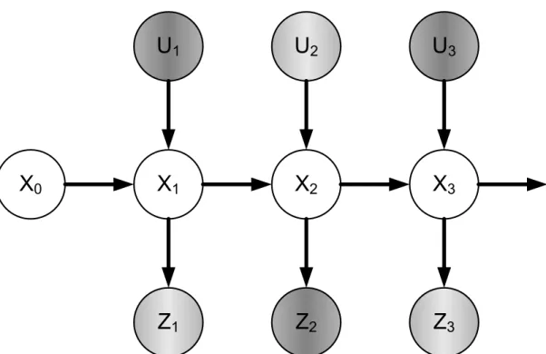
Figure 2.5 Dynamic Bayesian network: a framework for recursive state estimation... 32
Figure 2.6 Centralized operation architecture ... 36
Figure 2.7 Decentralized (or distributed) operation architecture... 37
Figure 2.8 Circular reasoning and over-convergence problem ... 39
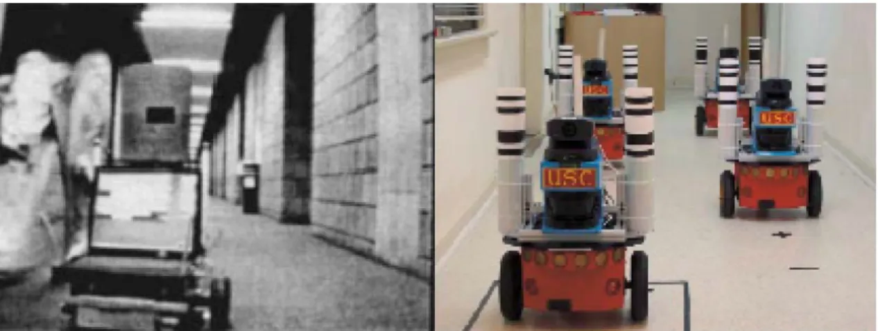
Figure 2.9 Intelligent vehicles (robots) with special patterns (Left picture from [Fox et al. 2000]; right picture from [Howard et al. 2006]) ... 42
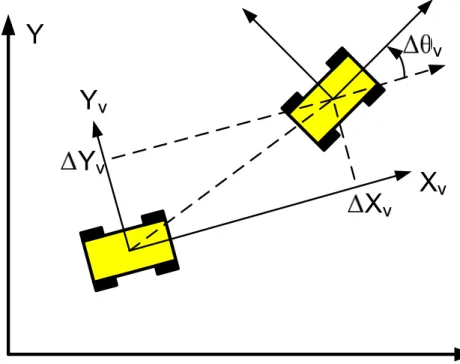
Figure 2.10 The relative pose of one vehicle with respect to another vehicle... 43
Figure 2.11 Direct representation (from [Lu & Milios 1997b]) ... 45
Figure 2.12 Features based representation (from [Guivant et al. 2000])... 46
Figure 2.13 Occupancy grid based representation... 47
Figure 2.14 Perceptions association: the object you see corresponds to what (or where) I see? ... 48
Figure 2.15 Augmented reality: ‘see’ through the front vehicle ... 55
Figure 3.1 Kinematic bicycle model... 68
Figure 3.2 Distributed cooperative localization procedures at one vehicle... 76
Figure 3.3 Indirect vehicle-to-vehicle relative pose estimation strategy... 78
Figure 4.2 The inverse measurement model p(m|St,zt)... 88
Figure 4.3 Dynamic Bayesian Network of incremental SLAM ... 89
Figure 4.4 Slide the local occupancy grid map with vehicle motion... 92
Figure 4.5 Crossover operation: (top) crossover I; (bottom) crossover II... 101
Figure 4.6 (top) local SLAM results; (bottom-left) maps alignment according to low-accuracy GPS based localization results; (bottom-right) maps merging result... 102
Figure 4.7 Cooperative moving objects detection (Cooperative MOD)... 103
Figure 5.1 Front-following vehicles scenario: (left) the view of the front vehicle; (right) the view of the following vehicle (occluded by the front vehicle) ... 110
Figure 5.2 Pinhole camera model ... 111
Figure 5.3 Multi-views perspective geometry ... 114
Figure 5.4 Coordinates systems in an intelligent vehicle ... 119
Figure 5.5 Approximate estimate of the visual perception depth... 121
Figure 5.6 Coordinates systems concerned in the calibration ... 123
Figure 6.1 Simulation scenario: a chain of vehicles ... 136
Figure 6.2 Performance of the SL method, the NCL method, the SECL method and the SCIFCL method (homogeneous absolute positioning ability) ... 138
Figure 6.3 RMS of the localization error associated with the SL method, the SECL method and the SCIFCL method (homogeneous absolute positioning ability)... 139
Figure 6.4 Performance of the SL method, the NCL method, the SECL method and the SCIFCL method (heterogeneous absolute positioning ability) ... 142
Figure 6.5 RMS of the localization error associated with the SL method, the SECL method and the SCIFCL method (heterogeneous absolute positioning ability)... 143
Figure 6.6 Experimentation field and the ground-truth of one vehicle trajectory ... 145
Figure 6.7 Performance of the SL method, the NCL method, the SECL method and the SCIFCL method (homogeneous absolute positioning ability) ... 146
Figure 6.8 RMS of the localization error associated with the SL method, the SECL method and the SCIFCL method (homogeneous absolute positioning ability)... 147
Figure 6.9 Localization results at the existence of counteracting GPS bias errors... 148
Figure 6.10 Performance of the SL method, the NCL method, the SECL method and the SCIFCL method (heterogeneous absolute positioning ability) ... 149
Figure 6.11 RMS of the localization error associated with the SL method, the SECL method and the SCIFCL method (heterogeneous absolute positioning ability)... 149 Figure 6.12 Estimated vehicle trajectories using the CL method and the SCIFCL method at the existence of GPS bias errors: (top) the first vehicle, with better absolute
positioning ability; (bottom) the second vehicle, with low-accuracy absolute positioning
accuracy ... 150
Figure 6.13 Ground-truth of local maps alignment: (Left) the two local occupancy grid maps; (Top-Right) the ground-truth; (Bottom-Right) Slight inconsistency ... 153
Figure 6.14 Occupancy grid maps merging effect... 154
Figure 6.15 Occupancy grid maps merging effect... 154
Figure 6.16 Occupancy grid maps merging effect... 155
Figure 6.17 Occupancy grid maps merging effect... 155
Figure 6.18 Occupancy grid maps merging effect... 156
Figure 6.19 Occupancy grid maps merging effect... 156
Figure 6.20 Occupancy grid maps merging effect... 157
Figure 6.21 Occupancy grid maps merging effect... 157
Figure 6.22 Occupancy grid maps merging effect... 158
Figure 6.23 Occupancy grid maps merging effect... 158
Figure 6.24 Histogram of the convergence evolution number ... 160
Figure 6.25 The pair of local occupancy grid maps to-be-merged... 161
Figure 6.26 Process of genetic evolution... 162
Figure 6.27 Re-convergence (or recovering) from kidnapping ... 163
Figure 6.28 Maps inherent inconsistency: synthetic data (top) two local maps; (bottom-left) correct maps alignment; (bottom-right) the wrong alignment ... 165
Figure 6.29 Maps inherent inconsistency: real-data (top) two local maps; (bottom-left) correct maps alignment; (bottom-right) the wrong alignment... 166
Figure 6.30 Cooperative moving objects detection: (left) local maps and single vehicle moving objects detection; (top-right) local maps merging; (bottom-right) merged moving objects... 167
Figure 6.31 Cooperative augmented reality effect: ‘see’ through front vehicle... 169
Figure 6.32 Cooperative augmented reality effect: ‘see’ through front vehicle... 170
Figure 6.33 Cooperative augmented reality effect: ‘see’ through front vehicle... 171
CHAPTER 1 Introduction
1.1 Context: Intelligent Vehicle Systems ... 3
1.2 Vehicles Cooperation... 4
1.3 Cooperative Perception... Error! Bookmark not defined. 1.3.1 Motivation... 10
1.3.2 Problem statement ... 14
1.4 Contributions ... 16
1.4.1 Cooperative Localization... 16
1.4.2 Cooperative Local Mapping and Moving Objects Detection ... 16
1.4.3 Cooperative Augmented Reality... 16
Résumé
Le thème de recherche de cette thèse est la perception coopérative multi-véhicules appliquée au contexte des systèmes de véhicules intelligents. L’objectif général des travaux présentés dans cette thèse est de réaliser la perception coopérative de plusieurs véhicules (dite « perception coopérative »), visant ainsi à fournir des résultats de perception améliorés par rapport à la perception d’un seul véhicule (ou « perception
1.1 Context: Intelligent Vehicle Systems
Vehicles (automobiles, ground vehicles) have been praised as one of the greatest inventions in modern history, as they have revolutionized our living mode and have contributed enormously to the development of modern society. Thanks to them, the living range and the working range of human beings have been largely enhanced. For example, we can take an exciting job in one town while enjoying a desirable habitation in another town.
Since several decades ago, researchers have been making efforts on incorporating various intelligent functions into traditional vehicles, with a goal of realizing intelligent
vehicle systems that make driving experience more convenient, more efficient, and safer.
Take some scenarios as examples, as follows:
Imagine that you are driving to Paris for the first time and you intend to go to a given destination whose location you do not know yet. In this case, an intelligent vehicle localization system [Skog & Handel 2009] can estimate current location of the vehicle, match the location onto a pre-stored digital map, and computes an itinerary to guide you from your current location to your destination. The localization system will update the estimate of vehicle location in real-time and always keep you on the correct itinerary. During your trip, you are a bit distracted by the exotic architectures on road sides and have not paid attention to gradual deviation of your vehicle; then an intelligent vision system that performs automatic lane detection [Li & Nashashibi 2011b] can monitor the vehicle-lane relative position and signal a lane departure warning message in time. You might have not paid attention to traffic lights or traffic speed signs either, then the vision system that performs traffic light detection [Charrette & Nashashibi 2009] and traffic speed sign detection [Moutarde et al. 2007] can also signal relevant message in time and display the traffic information.
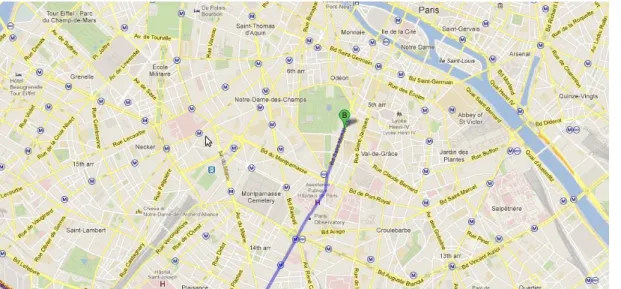
Figure 1.1 Vehicle navigation guidance with a digital map (modification on pictures from Google maps)
You might get tired of adjusting the vehicle speed; then an Adaptive Cruise Control (ACC) system [Vahidi & Eskandarian 2003] will liberate your foot from oil-pedal control and adjust the vehicle speed automatically. Suddenly, a pedestrian comes out from no where and rush across the road; for this sudden event, a system of pedestrian detection [Gate et al. 2009] will have rapid detection and recognition of the pedestrian and send proper commands to the vehicle controllers to avoid collision with the pedestrian.
After a long driving, you finally arrive at your destination, yet with a fatigued body. At this moment, an automatic vehicle parking system [Xu et al. 2000] will take charge of vehicle parking and save you from all these last steps of vehicle maneuvering.
Besides the examples listed above, an ocean of research works on intelligent vehicle systems can be found in literature. The research context of this dissertation is also the field of intelligent vehicle systems. In next sub-sections, we will specify our research focus in the context of intelligent vehicle systems (IVS).
1.2 Vehicles Cooperation
Most research works in the field of intelligent vehicle systems focus on SINGLE
vehicle operation, i.e. the intelligent vehicle performs environment perception,
decision making, and action execution, based only on its own sensor information and its own planning, without interacting with other intelligent vehicles.
A typical example is vision based autonomous navigation [Thorpe et al. 1988] [Pomerleau 1989], where the on-vehicle vision processing module (based on either
mono-camera or stereo-camera) process digital image data to generate vehicle control law directly or generate useful spatial information of the environment that can be used to guide the behavior of the vehicle. Another typical example is laser scanner based
simultaneous localization and mapping (SLAM) [Wang et al. 2003], the vehicle
establishes spatially consistent relationship among its sequence of observations, generates a consistent environment representation (the process of mapping), and localizes itself with respect to this environment representation (the process of
localization). Moreover, other examples of single intelligent vehicle operation can be
found in the applications of GPS-based vehicle localization and navigation [Kao 1991] [Abuhadrous et al. 2003], pedestrian detection [Enzweiler & Gavrila 2009], vehicle detection [Sun et al. 2006], general objects detection [Bertozzi & Broggi 1998] [Labayrade et al. 2005], and vehicle lateral control and vehicle longitudinal control [Rajamani 2005] etc.
The application background of intelligent vehicle systems is the outdoor traffic environment; a noticeable feature of outdoor traffic environment is that thousands of vehicles operate in the same environment. We can make a fair analogy between the outdoor traffic environment and our society, where an intelligent vehicle can be compared to an individual human being.
Each of us possesses the ability of sensing the environment and the ability of reacting to the environment; one has the potential to survive by one’s own ability, as how Robinson Crusoe did on a remote tropical island. In a society, however, we always cooperate with each other, instead of being totally independent. For example, when we arrive at a new place and want to search a certain street, we tend to consult some local passers-by for a quick access to our destination; without this cooperation, we might spend hours on searching the destination and suddenly find ourselves back again to a place we have passed by. When we want to enter into a cinema, we form a queue based on certain rule and pass the entrance orderly; without this cooperation, we would bump into the entrance randomly and might get stuck into a stalemate at the entrance.
In short, the cooperation among people in our society makes our lives more convenient and more efficient. Similarly, the cooperation among intelligent vehicle systems in traffic environment would also bring convenience and efficiency to traffic users.
Early motivation for performing vehicles cooperation lies in the idea of increasing infrastructure capacity via cooperative platooning (or cooperative adaptive cruise control) [Raza & Ioannou 1996] [Tsugawa et al. 2000] [Tsugawa et al. 2001] [Bruin et
al. 2004]. For a highway segment, its capacity is limited by the safety interval distance
capacity is. In cooperative platooning, down-stream vehicle can share its motion state and motion intention with upstream vehicles which can then take anticipatory actions and avoid jerk movements; as a result, the gap between neighboring vehicles can be reduced while string stable behaviors can be maintained, as illustrated in Figure 1.2. In other words, compared with non-cooperative platooning, cooperative platooning requires smaller safety distance, which can enhance highway capacity because vehicles can pass the highway segment more tightly.
Inter-vehicle communication
Vehicle sensing
Smaller safety interval
Figure 1.2 Vehicles platooning: (top) non-cooperative platooning; (bottom) cooperative platooning
Another motivation for performing vehicles cooperation stems from the need to guarantee navigation safety, which stimulates the development of cooperative collision warning-avoiding systems (CCWAS) [Li & Wang 2006] [Farahmand & Mili 2009] [Tan & Huang 2006]. Take an intersection scenario as an example, as illustrated in Figure 1.3. Vehicle A and Vehicle B move toward an intersection; they have several possible motion modes at the intersection. Some motion mode might result in a collision
accident if the drivers of the two vehicles misjudge the situation. With inter-vehicle communication, they can share the information of their position, motion state, and motion intention etc; then they can evaluate the possibility of collision. If a risk of collision exists, they can take proper actions in time to prevent collision from happening. Besides intersection scenarios [Chan & Bougler 2005] [Li & Wang 2006], cooperative collision warning-avoiding systems are also valuable for guaranteeing navigation safety at lane changing scenarios [Ammoun et al. 2007] [Li et al. 2005].
B A
Inter-vehicle communication
Moreover, the philosophy of vehicles cooperation has been applied to diverse kinds of scenarios, providing possible solutions for special demands of the society. For example, a new type of elderly driver assistance systems [Tsugawa et al. 2007] enables a host vehicle (driven by an assisting driver) to assist or escort the guest vehicle (driven by an elderly driver) through inter-vehicle communication. Europe has supported several large projects such as I-WAY [Rusconi et al. 2007], CVIS [Koenders & Vreeswijk 2008], and COOPERS [Piao & McDonald 2008], which attempt to integrate state-of-the-art V2V and V2I communication technologies and cooperative philosophy into comprehensive traffic scenarios.
1.3 Cooperative Perception
Generally speaking, single vehicle operation concerns two functionalities: perception and control. The vehicle perceives the environment and its own state, and then determines how to react to the environment; the vehicle repeatedly executes the procedures of perception and control, as illustrated in Figure 1.4.
Figure 1.4 Intelligent vehicle operation paradigm
Vehicles cooperation also concerns the functionalities of perception and control by each individual vehicle. Moreover, the vehicles in cooperation can share and fuse their perceptions, which results in the functionality of cooperative perception; they can also share their motion intentions and coordinate their actions, which results in the functionality of cooperative control. Besides cooperative perception and cooperative control, vehicles cooperation also concerns the functionality of vehicular
communication which plays a fundamental role for vehicles cooperation, as illustrated
Figure 1.5 Vehicles cooperation paradigm
This dissertation will focus on the functionality of cooperative perception; see the hierarchy of research areas in Figure 1.6. In the next sub-section, we will explain the value of cooperative perception in the context of intelligent vehicle systems and specify the problems and applications of cooperative perception concerned in this dissertation.
1.3.1 Motivation
As mentioned above, most research works in the field of intelligent vehicle systems focus on single vehicle operation; naturally, most research works on vehicle perception focus on the perception performed independently by a single vehicle.
Compared with single vehicle perception (or non-cooperative perception), the motivation for developing cooperative perception can be illustrated by a typical traffic scenario, i.e. an overtaking scenario as shown in Figure 1.7. A vehicle is overtaking another vehicle while the overtaken vehicle (the first vehicle) occludes the view of the overtaking vehicle (the second vehicle). This scenario is potentially dangerous; for example, in the case where a careless pedestrian is rushing across the road in front of the first vehicle, then what might happen?
First
Second
Figure 1.7 Overtaking scenario: potentially dangerous
For reasons of safety and efficiency, the second vehicle always wants to know: what objects are there occluded by the front vehicle? If there are some objects with risky trajectories, the second vehicle can make certain anticipatory actions such as deceleration or even braking-down. On the other hand, if there is no object, the second
vehicle can just keep going with high speed, this will be more efficient for the second vehicle and possibly other vehicles following the second vehicle.
Unfortunately, the second vehicle can never answer this question by itself, simply because it cannot perceive the occluded environment. No matter how good sensors and how good algorithms the second vehicle is using, it can not have any inference about the occluded environment. Then, a simple motivation for developing cooperative perception is to help the second vehicle answer this question. More specifically, the basic idea of cooperative perception is to let the first vehicle share its perception with the second vehicle, in order that the second vehicle can “perceive” the occluded environment.
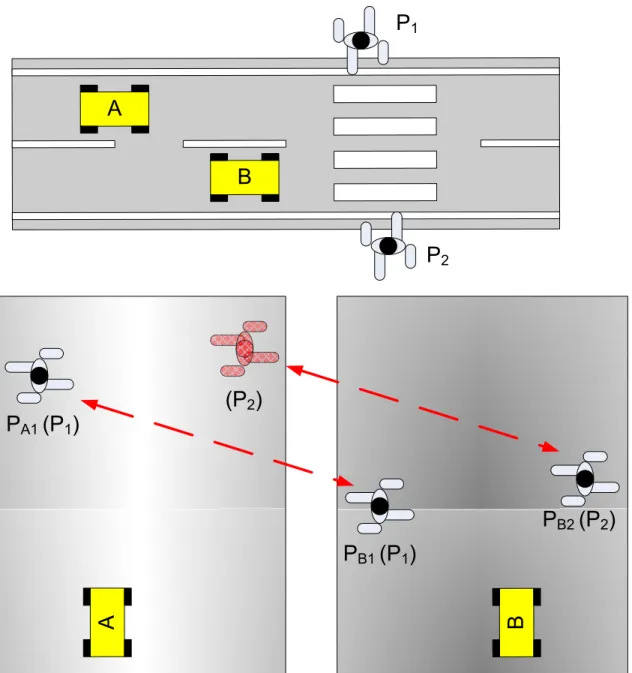
Another traffic scenario that demonstrates the value of cooperative perception is illustrated in Figure 1.8(top). Two vehicles A and B navigate in the same area; each of them has self-localization ability; they can also estimate the relative pose between them using their perception components.
Concerning the localization for vehicle B (similar reasoning can be carried out for vehicle A), the position of vehicle B can be estimated by vehicle B itself (shown in Figure 1.8(middle)). Besides, the position of vehicle B can be estimated indirectly from the perspective of vehicle A, as vehicle A can compound the estimate of relative pose between the two vehicles and the estimate of its own position (shown in Figure 1.8(bottom)).
A
Vehicle sensing B Vehicle sensing
Self-localization of A Self-localization of B
A
The location of vehicle B from its own perspective
B
Self-localization of B
A
Vehicle sensing B Self-localization of A
The location of vehicle B from the
perspective of vehicle A FUSION
Figure 1.8 Multi-vehicles cooperative localization
In other words, vehicle B can be localized based on two sources of data: one is of its own; the other one is of vehicle A. Better localization results might be achieved for vehicle B, if we fuse the two sources of data. The advantage of this fusion is especially noticeable for heterogeneous systems: imagine that vehicle A has high-quality positioning configuration whereas vehicle B has low-quality positioning configuration, then the high-quality positioning result of vehicle A can significantly improve the positioning results of vehicle B.
1.3.2 Problem statement
The general methodology of the presented works in this dissertation is to realize
multi-intelligent vehicles cooperative perception, which aims at providing better vehicle perception result compared with single vehicle perception (or non-cooperative perception).
Before further explanations for this methodology, we would like to review several underlying tasks of single vehicle perception. The essential purpose of vehicle perception is to provide relevant information, based on which the vehicle can decide how to react to the environment. For this purpose, first, the vehicle has to know its spatial state (position and orientation) with respect to a global reference, or to a local reference, or to both; the process of estimating this spatial state of the vehicle is usually referred to as vehicle localization (or localization for short). Second, the vehicle also has to establish spatial representation for the environment objects. Some environment objects are stationary, for example, buildings, road infrastructures etc; the process of establishing spatial representation for the stationary objects is usually referred to as
mapping. Some environment objects are moving (or dynamic), for example, moving
vulnerable road users; the process of establishing spatial representation for the moving objects is usually referred to as moving objects detection. The process of establishing spatial representation for both stationary objects and moving objects in the environment is referred to as mapping and moving objects detection. All these underlying tasks are important for successful and safe navigation of the vehicle.
When we extend single vehicle perception to multi-vehicles cooperative perception, we will naturally focus on the underlying issues of cooperative localization and
cooperative mapping and moving objects detection for cooperative perception.
Simply speaking, cooperative localization is a process where multiple vehicles perform localization cooperative, i.e. a vehicle can utilize the data of other vehicles to assist the localization of the vehicle itself. Similarly, cooperative mapping and moving objects detection is a process where multiple vehicles perform mapping and moving objects detection cooperatively, i.e. a vehicle can utilize the data of other vehicles to assist its tasks of mapping and moving objects detection.
It is worthy noting that the role of these cooperative perception functionalities is
optional instead of being mandatory. A vehicle can choose to cooperate with other
vehicles or not, depending on its judgement whether it can benefit from others or whether it can help others. For example, a vehicle with high quality GPS (Global Positioning System) and high quality IMU (Inertial Measurement Unit) might trust largely in its own positioning results and chooses not to fuse the positioning information
of other vehicles. It is like when we visit a new country, we tend to consult local people about our destinations (as we think local people are likely to be familiar with the local environment); if we find ourselves only with other foreigners nearby, we might choose to rely on ourselves to find our destinations (as we think these foreigners are unlikely to be familiar with the local environment).
Since the role of cooperative localization and cooperative mapping and moving objects detection is optional, then a question arises naturally: how to determine whether to perform these cooperative functions or not? However, we will not discuss about this issue in this dissertation, as this issue will deviate the research focus of cooperative perception. What we will tackle is: how to realize cooperative localization and how to
realize cooperative mapping and moving objects detection?
It is also worthy noting that cooperation is NOT omnipotent and we had better NOT expect that cooperative perception can unlimitedly make improvements over single vehicle perception. For example, we can not expect that two vehicles both with ten-meter level positioning accuracy can achieve centiten-meter-level accuracy through cooperative localization. The performance of cooperative perception largely depends on the perception ability of each individual vehicle in cooperation. The better the single vehicle perception is, the better the cooperative perception tends to be.
Therefore, instead of focusing our research works on the absolute performance of cooperative perception, we would rather focus on the general mechanisms which
enable the realization of above mentioned cooperative perception functionalities based on commonly used sensor configurations; we would rather examine the advantages of these cooperative perception functionalities relative to single vehicle perception.
The final goal for developing intelligent vehicle systems in the long run is that all the vehicles in our society can reliably operate in full automated mode (or with only few human interventions such as designating the destination of the vehicle users). However, there is still considerable gap between current technical ability and the ability to achieve above goal. Before this final goal becomes true, it would be desirable that current techniques can be adapted for driver assistance. Better visualization of vehicle perception results would better assist the driver to judge the environment. Augmented
reality techniques can make the perception visualization more direct and more vivid,
which are commonly used in driver assistance oriented applications. Concerning cooperative perception, we will study the possibility of taking advantage of
cooperative perception to generate augmented reality effects that would be valuable for drivers, which we name as cooperative augmented reality.
1.4 Contributions
The contributions of the presented works in this dissertation consist in three aspects: cooperative localization, cooperative local mapping and moving objects detection, and cooperative augmented reality.
1.4.1 Cooperative Localization
We provide a solution of multi-vehicles cooperative localization (CL). First, we make an abstraction of the basic functionalities that are commonly available in the context of intelligent vehicle systems. Based on these abstracted functionalities, we propose a general architecture of cooperative localization using split covariance intersection filter. Second, concerning the functionality of vehicle-to-vehicle relative pose estimation that is fundamental for realizing cooperative localization, we propose a new method i.e. the
indirect vehicle-to-vehicle relative pose estimation method to perform this functionality.
We carry out a simulation based comparative study among the proposed cooperative localization architecture and several reference methods. Besides simulation, we also carry out cooperative localization in reality and present the results of real-data tests.
1.4.2 Cooperative Local Mapping and Moving Objects Detection
We provide a solution of cooperative local mapping and moving objects detection for laser scanner based intelligent vehicles. The method architecture is as follows: each vehicle establishes in real-time a local occupancy grid map and performs moving objects detection based on the established occupancy grid map. During vehicles cooperation, the local occupancy grid maps of different vehicles are merged, so that these different vehicles can be spatially related to each other; then the moving objects detection results of these vehicles can also be merged. As part of this method architecture, a new method for occupancy grid maps merging is proposed, which consists in a new objective function that measures the consistency degree of maps alignment and a genetic algorithm that searches for the optimal maps alignment.
We carry out real-data tests on the proposed method and demonstrate its performance.
1.4.3 Cooperative Augmented Reality
We will extend the spirit of augmented reality to cooperative perception, forming the concept of cooperative augmented reality (CAR) in the context of intelligent vehicle systems. We provide a solution of cooperative augmented reality, which integrates the techniques of cooperative local mapping and augmented reality to generate an
augmented reality effect of ‘seeing through’ front vehicle. As part of the provided solution, a new method is proposed for extrinsic co-calibration of a camera and a 2D laser scanner.
We will demonstrate the ‘seeing through’ effect of the introduced cooperative augmented reality method, based on real-data tests.
1.5 Thesis Outline
This dissertation is organized as follows: In chapter 2, we review in details the problems and the state-of-the-art methods concerned in the cooperative perception issues discussed in this dissertation. From chapter 3 to chapter 5, we respectively introduce our solutions of cooperative localization, cooperative local mapping and moving objects detection, and cooperative augmented reality. In chapter 6, we describe concrete implementation and integration of the proposed methods on our experimental vehicle platforms and demonstrate experimental results. In chapter 7, we summarize the works presented in this dissertation and discuss about their future extensions.
CHAPTER 2 Cooperative Perception –
State-of-the-Art
2.1 Introduction... 21 2.2 Intelligent Vehicle Sensor Configurations... 21
2.2.1 Global Positioning System (GPS) ... 21 2.2.2 Laser Scanner... 23 2.2.3 Camera... 24 2.2.4 Motion Sensor... 25 2.2.5 Integration... 25 2.3 Recursive State Estimation ... 26
2.3.1 State, State Estimation, and Perception ... 26 2.3.2 Vehicle-Environment Interaction ... 27 2.3.3 Recursive Estimation: Bayesian Filter Framework ... 30 2.3.4 Kalman Filter ... 32 2.3.5 Incremental Maximum Likelihood Estimation... 34 2.3.6 Sampling-based Method: Particle Filter ... 35 2.4 Cooperative Localization... 35
2.4.1 Operation Architecture ... 35 2.4.2 How to Handle Inter-Estimates Correlation? ... 37 2.4.3 Vehicle-to-Vehicle Relative Pose Estimation ... 41 2.5 Cooperative Local Mapping and Moving Objects Detection ... 43
2.5.1 Perception Representation ... 43 2.5.2 Perceptions Association... 47 2.5.3 Vehicle Pose Estimation based Methods... 49 2.5.4 Perceptions Consistency based Methods ... 50 2.5.5 Local Occupancy Grid Maps Merging ... 53 2.5.6 Moving Objects Detection... 54 2.6 Cooperative Augmented Reality... 55 2.6.1 Augmented Reality Effect of ‘Seeing’ Through Front Vehicle... 55 2.7 Summary... 56
Résumé
Dans nos travaux, nous avons exploité plusieurs sortes de capteurs, à savoir un GNSS à base de GPS, un télémètre laser, une caméra, et des capteurs odométriques. Ces capteurs sont souvent employés pour le fonctionnement d’un véhicule intelligent et, grâce à ceux-ci, un véhicule intelligent est doté d’une capacité de perception assez complète lui permettant d’assurer sa propre localisation et la perception proprement dite de l’environnement. Afin d’assurer la localisation du véhicule, une architecture à base de filtre Bayésien a été examinée ; celui-ci est couramment utilisé pour l'estimation d'état récursive. Ainsi, un rappel des diverses méthodes d'estimation récursives dérivées de l’architecture de filtre Bayésien est fait. Dans la suite, sont discutés en détail les problèmes fondamentaux et les méthodes existantes dans l'état-of-the-art concernant la localisation et la cartographie locale coopératives. D’après ces réflexions, nous proposons une architecture générale de localisation coopérative en utilisant le « split covariance intersection filter » (ou SCIF), une méthode de l’estimation indirecte de la localisation relative Véhicule-à-Véhicule. De même, une nouvelle méthode de fusion de grilles d’occupation est présentée et ce, afin de traiter les problèmes fondamentaux en matière de la localisation coopérative et de cartographie locale coopérative.
2.1 Introduction
As we have stated in previous chapter: the performance of cooperative perception largely depends on the perception ability of each individual vehicle in cooperation; instead of focusing our research works on the absolute performance of cooperative perception, we would rather focus on the general mechanisms which enable the
realization of previously mentioned cooperative perception functionalities based on common used sensor configurations; we would rather examine the advantages of these cooperative perception functionalities relative to single vehicle perception.
Therefore, before going into detailed discussion on the cooperative perception issues, we had better first give an introduction of the state-of-the-art sensor configurations that are common for single intelligent vehicle operation. This can provide a baseline for our research works: First, concerning methodology, we can judge whether the proposed methods are generally applicable to vehicles with common sensor configurations? Second, concerning performance, we can examine what benefits can cooperative perception bring to vehicles with common sensor configurations?
The execution of a perception task can be basically treated as a process of estimating certain state of interest (vehicle pose, environment map etc) based on the measurements of certain vehicle sensors. Following the introduction of intelligent vehicle sensor configurations, we would like to introduce some general mathematical foundations of estimation theory, which have been widely applied in real-time vehicle perception tasks. Then, we study in details the problems and the state-of-the-art methods concerned respectively in the issues of cooperative localization, cooperative local mapping and moving objects detection, and cooperative augmented reality, which have been briefly introduced in previous chapter.
2.2 Intelligent Vehicle Sensor Configurations
We review several kinds of sensors that are commonly used in nowadays intelligent vehicles.
2.2.1 Global Positioning System (GPS)
The Global Positioning System (GPS) is part of a satellite-based navigation system developed by the United States Department of Defense under its NAVSTAR satellite program. More detailed description of the history and technologies of the GPS can be found in an ocean of literature on this topic; refer to [Grewal et al. 2001] [Farrell &
Barth 1998] for examples. Briefly speaking, a GPS receiver (with related processing units) can provide information of its location and the GPS universal time, via analysis of the signals transmitted by the GPS satellites whose orbital information is known. Several factors account for the popularity of the GPS in the applications of intelligent vehicle systems: First, it can provide positioning measurement with respect to a global reference (a reference fixed with the environment where the intelligent vehicles operate). Second, it can provide the global positioning measurement directly, without the need for certain extra conditions such as pre-registration works about the operation environment. Third, it can provide error-bounded positioning measurement, without suffering from accumulated positioning errors.
Although the U.S. America was the first to develop satellites-based global positioning system, yet nowadays it is not the only provider of satellites-based global positioning services. Some other entities such as Russia, Europe, and China have also been developing global positioning systems (in different names); for example, the GLObal Navigation Satellite System (GLONASS) by Russia, the GALILEO positioning system by European Union, and the COMPASS (or Bei Dou in Chinese) navigation system by China. Therefore, in this dissertation, the referring of the terms global positioning
system (GPS) does not necessarily indicate that specific system developed by U.S.A,
but generally indicates any possible system which performs the functionality of global positioning based on satellites.
Figure 2.1 Satellites-based global positioning systems (modification on pictures from Huan Qiu Shi Bao i.e. Global Times)
2.2.2 Laser Scanner
Laser scanner, or in other names such as laser rangefinder, laser telemeter, is a kind of device that can measure its distance to environment objects by emitting laser beams, receiving the reflection of the laser beams, and computing the distance traversed by the laser beams.
A laser scanner can rapidly provide reliable range measurements with fairly small range errors (centimeter level errors). In other words, a laser scanner enables a vehicle to
efficiently monitor the spatial relationship between the vehicle and the surrounding objects. As a result, laser scanner plays an important role in guaranteeing vehicle navigation safety, especially for the purpose of environment objects collision avoidance (avoiding collision onto vulnerable road users, other vehicles, environment infrastructure etc).
Figure 2.2 Range measurements provided by a laser scanner
2.2.3 Camera
Cameras can provide a kind of sensing data that is related to the most important perception system of human beings, i.e. our vision. As our vision provides the most part of information for our reasoning about the environment, cameras can also provide a large amount of information for intelligent vehicle systems to make inference about the environment. For example, based on vision data, on-vehicle vision systems can perform tasks of lane marks detection and traffic signs detection that are almost impossible for other kinds of perceptive sensors such as laser scanners. Vision data provide plenty of
clues for automatic recognition of environment objects (pedestrians, vehicles etc). Besides, camera data (original or with certain visualization effects) can be easily comprehended by human beings, which makes cameras valuable for the purpose of driver assistance, human-machine interaction etc.
2.2.4 Motion Sensor
Motion sensors are a kind of proprioceptive sensors (in contrast with exteroceptive sensors such as cameras and laser scanners) that are usually equipped on an intelligent vehicle to monitor vehicle motion state (longitudinal motion and lateral motion). Motion sensors used for intelligent vehicles include odometers (including steering encoders), accelerometers, gyroscopes etc.
Normally, motion sensors can output motion measurements at comparatively high frequency (for example, 100 Hz). Therefore, motion measurements can be used to predict vehicle state when other sorts of measurements are temporarily unavailable. Besides, motion measurements can be fused with other sorts of measurements to enhance the accuracy of vehicle state estimates.
2.2.5 Integration
We have briefly introduced several sorts of sensors, namely GPS, laser scanner, camera, and motion sensor. For certain specific application, we might be able to resort to only one sort of these sensors. For example, for lane detection and lane following, we only need a vision system.
On the other hand, it has been a tendency to incorporate all these sensors into an intelligent vehicle, in order that the vehicle possesses fairly complete perception ability towards itself and the environment. The reasons are two-folds:
First, the functionality of each sort of these sensors is irreplaceable by the others. Without GPS, the vehicle has no error-bounded inference about its global position. Without camera, the vehicle has no visual data for computer-based image processing or for human-oriented visualization. Without laser scanner, the vehicle can not have range data of high reliability and accuracy. Without motion sensor, the vehicle can not have direct monitoring of its motion state.
Second, the availability of all these sensors can complement each other and facilitate the functioning of each other. In other words, they are mutually beneficial. For example, motion data can be used to facilitate processing of range data and vision data; they can be fused with global positioning measurements. Range data based processing results can be used to correct motion data.
An example of intelligent vehicle equipped with GPS, laser scanner, camera, and motion sensors is illustrated in Figure 2.3.
Figure 2.3 Intelligent vehicle sensor configurations (CyCab vehicle platform)
2.3 Recursive State Estimation
2.3.1 State, State Estimation, and Perception
The term state is frequently adopted in a wide range of domains; the definition of state depends on concrete research and application areas. In the context of intelligent vehicle systems, we could generally think state as the collection of all properties of the vehicles and the environment. In reality, however, we can not really deal with all the properties, because they are infinite. In fact, we do not need to deal with all the properties; for example, we do not need to care about that an intelligent vehicle consists of how many molecules. In other words, we need to selectively deal with partial properties of the vehicles and the environment that are important in certain sense; then we treat these
partial properties as state. As in this dissertation, we deal with the spatial properties of the vehicles and the environment and treat them as state.
State estimation addresses the problem of estimating the state of interest (the properties
we care about) via analysis of sensor data. The need for state estimation lies in two aspects of reasons: First, certain state elements might not be directly observable from sensor data; they can only be inferred from sensor data. For example, GPS only outputs position measurement for the vehicle, whereas vehicle orientation can only be inferred from the process of vehicle pose estimation i.e. vehicle localization. Second, for those state elements directly observable from sensor data, techniques such as filtering and data fusion in state estimation can reduce the uncertainty of the raw sensor data of these state elements.
After a brief introduction of state and state estimation, now we could further specify the meaning of perception. Literally, perception means 1) the ability of perceiving (sensing, recognizing etc), 2) the process of perceiving, and 3) the result of perceiving. In this dissertation, the perception, when used in general manner, still conveys all these senses of meaning. For example, cooperative perception implies the ability of perceiving cooperatively, the process of perceiving cooperatively, and the results of perceiving cooperatively.
Concerning the third sense of meaning i.e. the result of perceiving, the perception only implies current result of perceiving, as we focus on real-time vehicle perception. In other words, the perception means current state estimate that might be obtained based (directly and indirectly) on analysis and fusion of a temporal sequence of sensor measurements. For example, when we express “a vehicle shares its perception with another vehicle” or “associate the perceptions of two vehicles”, here, the perception has such sense of meaning i.e. the current state estimate maintained by a vehicle.
2.3.2 Vehicle-Environment Interaction
During the operation of an intelligent vehicle, it gets sensor measurements about itself and the environment. We can assign its sensor measurements into two categories: vehicle proprioceptive measurements and vehicle exteroceptive measurements. The terms proprioceptive and exteroceptive have been briefly mentioned in the introduction of motion sensors; here we would like to explain their difference.
Vehicle proprioceptive measurements: the proprio means “of one’s own”; vehicle
proprioceptive measurements are measurements that only concern the vehicle itself. Vehicle motion measurements belong to such kind of measurements.
![Figure 2.11 Direct representation (from [Lu & Milios 1997b])](https://thumb-eu.123doks.com/thumbv2/123doknet/11338813.283978/63.918.149.520.148.485/figure-direct-representation-from-lu-amp-milios-b.webp)
![Figure 2.12 Features based representation (from [Guivant et al. 2000])](https://thumb-eu.123doks.com/thumbv2/123doknet/11338813.283978/64.918.141.517.136.434/figure-features-based-representation-guivant-et-al.webp)