L’Université de Montréal
Densification & Affordability: Comparative Real Estate Projects across Montreal
par Enoch Tim Ho
Institut d’Urbanisme Faculté d’Aménagement
Mémoire présenté à la Faculté d’Aménagement en vue de l’obtention du grade de Enoch Tim Ho en Maîtrise d’Urbanisme
Octobre 2014
RÉSUMÉ
Mots Clés : densification, abordabilité, Smart Growth, tendances démographiques, condos
Montréal, Québec se construit vers une forme urbaine compacte, mais il en relève des questionnements quant aux effets sur l’abordabilité et l’accession à la propriété. En tenant compte du processus de la densification urbaine, une enquête sur une série de projets de condominiums immobiliers à travers la ville est menée afin de divulguer les prix des projets nouveaux ou en construction. Au préalable, ceci survole la littérature et les études actuelles portant sur la planification urbaine, notamment celles qui sont reliées au Smart Growth, études dans lesquelles le contexte de densification et de tendances consuméristes à préférer les formes urbaines étalées est mis en évidence. Essentiellement, Moroni (2010) souligne l’approche dichotomique en planification urbaine entre les perspectives «teleocratic» et «nomocratic». La densification montréalaise actuelle contemporaine s’exprime par une multitude de modèles de condos conformes aux nouvelles tendances démographiques et des modes de vie. En s’appuyant sur les critères du programme Accès Condos, sur les critères du SCHL (32% du revenu) et sur le revenu médian des ménages, le niveau d’accessibilité à la propriété d’un condominium peut être mesuré. Les résultats indiquent que selon ces critères, les logements de style condominium, neufs et en construction, sont abordables.
L’analyse contribue empiriquement à la littérature en exposant les liens entre les stratégies actuelles de densification urbaine avec l’abordabilité des logements condos. La recherche porte un regard nouveau sur le phénomène condo à Montréal et ses tendances démographiques. La ville est divisée selon le modèle Burgess et la recherche mène un sondage comparatif des prix pour déterminer l’abordabilité. Les résultats suggèrent que les projets condos actuels sont relativement abordables pour les ménages avec un revenu médian et plus, selon Accès Condos.
A
BSTRACT
Key Words: densification, affordability, Smart Growth, demographic trends, condos
Montreal, Quebec is building towards a more compact urban form and there is a fundamental questioning of its effect on home-ownership affordability. Using the process of densification, a survey on a range of real estate condominium projects across the city is conducted to divulge the prices of new or in-construction projects. Beginning with a literature review of the most up to date planning stratagems, notably Smart Growth initiatives, the context for densification and consumerist tendencies to prefer sprawled urban forms is highlighted. Fundamentally, there is a teleocratic versus nomocratic planning approach that must be decided upon. Contemporary densification in Montreal is expressed in a myriad of condominium designs conforming to new demographic trends and lifestyles. Using existing criteria by Accès Condos, the projects are compared and validated as to whether or not condominium unit prices are affordable. As a result, new or in-construction condominium units are found to be affordable with respect to the Accès Condos programme and to median income households.
The analysis contributes empirically to the literature by relating the impetus of densification strategies with levels of affordability. The research takes a fresh look into Montreal's own condominium phenomenon alongside trending demographic studies. Using Burgess' spatial segregation of the city, a cross comparison survey tests for affordability across Montreal. The findings suggest that current projects are relatively affordable for median income earning households as per AccèsCondos.
T
ABLES OF CONTENTS
P
REFACE
–
C
ROSSROADS
21
C
HAPTER
1
–
D
IRECTING
I
NSATIABLE
B
UILDING
24
C
HAPTER
2
–
H
OUSE OF
C
ARDS
:
A
FFORDABILITY
52
C
HAPTER
3
–
J
OURNEY TO THE CENTRE OF
H
OUSING
70
C
HAPTER
4
–
B
RIGHT
L
IGHTS
B
IG
C
ITY
86
C
HAPTER
5
–
T
HE
B
EGINNING AND
E
ND
121
LIST OF T
ABLES
Table 1-1. Attributes of Sprawl and corresponding academic reference (Compiled by Ho 2014).
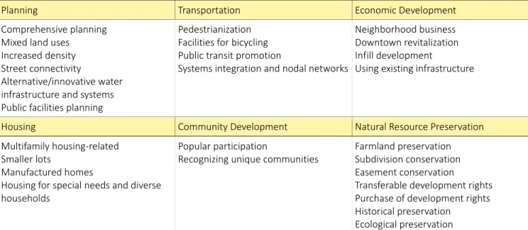
Table 1-2. The Main Elements of Smart Growth Policies including planning, transportation, economic development, housing, community development, and natural resource preservation.
(Source: Ye et al 2005)
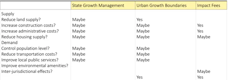
Table 1-3. Theoretical Impacts of Growth management on Housing Supply and Demand. (Source: Addison et al 2013)
Table 1-4. Theoretical Impacts of Growth management on Housing Supply and Demand. (Source: Addison et al 2013).
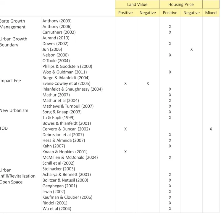
Table 1-5. Empirical Results of Growth Management Practices on Land Value, Housing Price, and Affordability
(Source: Addison et al 2013)
Table 1-6. Empirical Results of Growth Management Practices on Land Value, Housing Price, and Affordability
(Source: Addison et al 2013)
Table 2-1. Housing Affordability Stress in Canadian Metropolitan Areas using economic change, social/demographic change, and policy change as factors accounting for housing affordability stress and homelessness.
(Source: Bunting et al 2004)
Table-3-1. Excel headers for organizing and calculating data (Source: Enoch Ho 2014)
Table-3-2. Example of median, Mean, and range of various condominium factors (Source: Enoch Ho 2014)
Table-3-3. Example of demographic revenue brackets used and frequency (Source: Enoch Ho 2014)
Table-3-4. Example of table used for separating # of rooms, revenue brackets, and frequency (Source: Enoch Ho 2014)
Table 3-5. Example of table used for summary table (Source: Enoch Ho 2014)
Table-3-6. Example of table used for revenue market brackets and frequency (Source: Enoch Ho 2014)
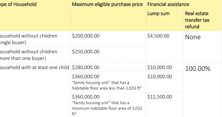
Table 4-1. Accès Condos table indicating maximum eligible purchase prices for various household types. (Source Accès Condos 2014).
Table 4-2. Annual Revenue per household.
(Source: Statistics Canada customized table from the Census in 2001 and 2006) Table 4-3. Median Revenue per household composition and type of tenure. (Source: Statistics Canada customized table from the Census in 2001 and 2006)
Table 4-4. Griffintown: Demographic Profile broken down into proportion of various household compositions.
(Source: Statistics Canada customized table from the Census in 2001 and 2006) Table 4-5. Griffintown Projects 2014: Under construction or newly finished. (Source: Enoch Ho 2014)
Table 4-6. Griffintown Projects 2014: Under construction or newly finished. (Source: Enoch Ho 2014
Table 4-7. Annual revenue (2005) by household and tenure type for the city of Montreal, the South-West borough and the CDN-NDG borough.
(Source: Statistics Canada customized table from the Census in 2001 and 2006) Table 4-8. Annual revenue (2005) by household for the city of Laval.
(Source: Statistics Canada customized table from the Census in 2001 and 2006)
Table 4-9. Median Revenue (2005) according to household composition and type of tenure for the CMM, the city of Montreal, the South West borough, and the CDN-NDG borough.
(Source: Statistics Canada customized table from the Census in 2001 and 2006) Table 4-10. Median Revenue (2005) according to household composition (Source: Statistics Canada customized table from the Census in 2001 and 2006)
Table 4-11. Sample Size, # floors, and # units across Griffintown, Le Triangle, and Laval projects. (Source: Enoch Ho 2014)
Table 4-12. Griffintown projects 2014: under construction or newly finished. Statistical summary of condo prices, income required for 80% & 90% mortgage for 32% affordability, floor area, total annual expenditure for 80% & 90% mortgage, and #rooms.
Table 4-13. Le Triangle projects 2014: under construction or newly finished. Statistical summary of condo prices, income required for 80% & 90% mortgage for 32% affordability, floor area, total annual expenditure for 80% & 90% mortgage, and #rooms.
(Source: Enoch Ho 2014)
Table 4-14. Laval projects 2014: under construction or newly finished. Statistical summary of condo prices, income required for 80% & 90% mortgage for 32% affordability, floor area, total annual expenditure for 80% & 90% mortgage, and #rooms.
(Source: Enoch Ho 2014)
Table 5-1. Housing continuum from emergency shelters to market home-ownership housing. (Source: CMHC 2014)
Table 5-2. Proportion of Condominium Units deemed affordable as per Accès Condos (Source: Enoch Ho 2014)
Table 5-3. Median multiple of the CMM is illustrated and compared with project median multiples or the ratio of new median housing price (per area of interest) to the median revenue of the CMM (per area of interest).
(Sources: Enoch Ho 2014; Statistics Canada customized table from the Census in 2001 and 2006; the Gazette 2013)
Table 5-4. Median multiple of the CMM is illustrated and compared with project median multiples or the ratio of new median housing price (per area of interest) to the median revenue of all home-owners in the CMM (per area of interest).
(Sources: Enoch Ho 2014; Statistics Canada customized table from the Census in 2001 and 2006; the Gazette 2013)
Table 5-5. Revenue required for 32% of housing costs to be allocated to median housing price across Griffintown, Le Triangle, and Laval
(Source: Enoch Ho 2014)
Table 5-6. Median multiple of area using median housing price per project area and required revenue for 32% affordability
(Sources: Enoch Ho 2014)
Table 5-7. Difference in housing stresses measured with median multiple – ideal versus current (Sources: Enoch Ho 2014)
Table 5-8. The real cost of an affordable condominium unit for CMM’s median income earners and for home-owners’ median income earners.
LIST OF FIGURES
Figure 3-1. The thought process for choosing a topic. (Souce: Enoch Ho 2014)
Figure 4-1. Housing Affordability Stress and low-rent neighborhoods across different Canadian metropolitan areas.
(Source: Bunting et al 2004)
Figure 4-2. Condo starts in Quebec from 1985 to 2011. (Source: CMHC & Desjardins Economic Studies 2013)
Figure 4-3. Condo resale market from 1991 to 2011 comparing the Montreal CMA to the Quebec CMA. (Source: CMHC & Desjardins Economic Studies 2013)
Figure 4-4. The Number of condos under construction from 2002 to 2012 comparing the CMA, the Island, and the downtown.
(Source: CMHC & Desjardins Economic Studies 2013)
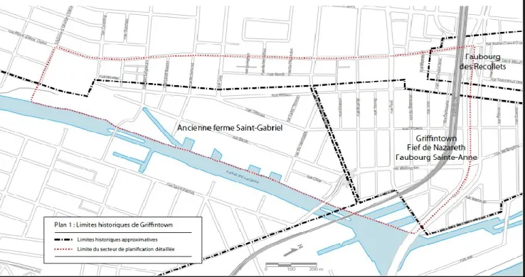
Figure 4-5. Historic (black) versus planned (red) borders of Griffintown. (Source PPU Griffintown 2013)
Figure 4-6. PPU’s planned demolition (reflected in the brownish-orange color) (Source PPU Griffintown 2013)
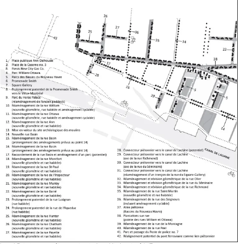
Figure 4-7. An Inventory of interventions in the public domain of Griffintown. (Source: PPU Griffintown 2013)
Figure 4-8. An inventory of interventions in the public domain of Griffintown continued. (Source: PPU Griffintown 2013)
Figure 4-9. Sample of units divided into revenue market of buyers at 32% affordability and 90% mortgaged.
(Source: Enoch Ho 2014)
Figure 4-10. Sample of units divided into revenue market of buyers at 32% affordability and 80% mortgaged.
(Source: Enoch Ho 2014)
Figure 4-11. The number of rooms & corresponding revenue required at 32% affordability using a 90% mortgage.
Figure 4-12. The number of rooms & corresponding revenue required at 32% affordability using an 80% mortgage.
(Source: Enoch Ho 2014)
Figure 4-13. The division of Montreal according to the Burgess Model: 1) Griffintown as the city center, 2) Le Triangle as the inner-city, and 3) Laval as the commuter zone.
(Source: Enoch Ho 2014)
Figure 4-14. Polycentric Bid-Rent Curve reflecting a new reality of traditional land prices due to changes in the urban configuration of housing and transportation.
(Source: Enoch Ho 2014)
Figure 4-15. Sample of units divided into revenue market of buyers at 32% affordability and 90% mortgaged in Griffintown.
(Source: Enoch Ho 2014)
Figure 4-16. Sample of units divided into revenue market of buyers at 32% affordability and 90% mortgaged in Le Triangle.
(Source: Enoch Ho 2014)
Figure 4-17. Sample of units divided into revenue market of buyers at 32% affordability and 90% mortgaged in Laval.
(Source: Enoch Ho 2014)
Figure 4-18. The number of rooms & corresponding revenue required at 32% affordability using a 90% mortgage in Griffintown.
(Source: Enoch Ho 2014)
Figure 4-19. The number of rooms & corresponding revenue required at 32% affordability using a 90% mortgage in Le Triangle.
(Source: Enoch Ho 2014)
Figure 4-20. The number of rooms & corresponding revenue required at 32% affordability using a 90% mortgage in Laval.
(Source: Enoch Ho 2014)
Figure 4-21. Summary of Actual revenue segments versus project segments to compare the current demographic market with the market being created.
LIST OF ACRONYMS AND ABBREVIATIONS
BIDs Business Improvement Districts BMO Bank of Montreal
CDN-NDG Côte-des-Neiges-Nôtre-Dame-de-Grâce
CMA Census Metropolitan Area
CMHC Canadian Mortgage Housing Corporation CMM Communauté Métropolitain de Montréal CTV Canadian Television
GST Goods and Services Tax
HUD Department of Housing and Urban Development
IMF International Monetary Fund LICO Low Income Cutoff
LIHTC Low Income Tax Credit
LIM Low Income Measures LMI Low to Moderate Income MBM Market Basket Measure NHA National Housing Act
PPU Programme Particulier Urbain PST Provincial Sales Tax
RBC Royal Bank of Canada
SAHT South Australian Housing Trust SHDM Société d'Habitation et de Développement de Montréal TOD Transit Oriented Development TD Toronto Dominion
A
CKNOWLEDGMENTS
This work is the result of many thoughts, discussions, and interesting reads, such that I cannot possibly acknowledge all sources of aid.
Thank you God for providing me with wisdom, faith, courage, and humility
Pillars of support, patience, and reflection: my loving family and wonderful girlfriend My fantastic, helpful guidance, and teacher: Daniel Gill
To those who helped me with technical support,
who kindly and graciously used their time: Timothy Chen, Timothy Tsang, and Liz Collin. All my friends and co-workers who wished me the best of luck.
And to my TNT brothers and sisters, for their love, prayers, and support.
“Health is wealth, money is poker chips. Everything else is bullshit and gun smoke except God, Family and friends” - Harry Platis
MEMBRES DU JURY
Président-Rapporteur : Jean-Philippe Meloche Ph.D. Géo (M.sc. écon., B. écon.), Professeur adjoint
Directeur de recherche : Daniel Gill, M. ATDR (B.Sc. en géographie), Professeur agrégé
P
REFACE
C
ROSSROADS
“The only source of knowledge is experience” – Albert Einstein
Shelter is a fundamental human need. From the beginning of time, the concept of a physical dwelling and home as a space tending to our most primitive physiological and emotional needs – including resting, eating, and reproducing – has always been highly vested as a basic component to life and communal gathering. From the Indus Valley civilization to the Aegean civilization, shelter has proven itself significant. Because land has always been a limited benefaction, society has always sought to house people in the most efficient and effective ways. In other words, people have been innovating dense living configurations from early periods to the contemporary skyscraper behemoth. At the juncture, there is a questioning of society’s functionality and values, in which productivity and compassion are embroiled into a debate on the level of housing accessibility and the rights to housing.
Simply put, this research attempts to understand society’s provision of denser shelter-types and its process for housing people. Using the unique cityscape of Montreal, Quebec, it seeks to understand its current state of housing affordability and how its density factors into the costs of housing in the broader context. With an interesting Anglo-French influence dating back to the 17th Century, Montreal’s
housing stock is comprised of a myriad of architectural typologies. In the following research, Montreal’s new condominium development, as part of the city’s Master plan expansion of the downtown and other sectors, is uncovered as a story of densification and its effect on housing affordability.
Because there are many aspects to city planning, there is a focus on the city’s densification effect on housing affordability. Planners often address transportation, open spaces, public services and amenities, land-uses, and new development patterns, but focusing purely on the densification process will also allow some of these issues to be addressed tangentially. That said, the narrow lens of studying housing affordability through the densification process proves insufficient as a holistic explanation in understanding the urban condition. The city of Montreal is currently modifying its Master Plan to densify and revitalize specific areas. The general orientation remains to optimize housing density and typologies in the right areas, and prescribe modifications where needed such that levels of affordability can remain acceptable.
Residential density is an extremely valuable concept to understand from a design perspective as it embodies the physical image of a city and because there are practical implications and relations to issues like housing affordability. Density can be a visual representation of a city’s economic capacity, diversity, and power. As a result of both scarcity and desirability of select lands, the laws of supply and demand optimize residential development by building both vertically and more densely. This concept is explicative in the strategy to densify residential development, but there are questions as to its effect on access to housing.
The control of building densities plays an important role in the provision of affordable housing, but it is also the point of contact between economic, political, social, and environmental forces. These larger issues play an indirect, but fundamental role in the formation of urban densities and housing affordability. While the density of a city may seem like a rather unimportant indicator, there are some fundamental questions as to its effect on elements like housing affordability. For example, why is it that super dense cities like Hong Kong and Vancouver also have the highest levels of unaffordable housing?
This research focuses on a Canadian context and how the compact city is increasingly becoming favored over sprawled development. In an effort to curb the inefficiencies and unsustainability of sprawl, contemporary planners look to new urban paradigms like Smart Growth, which at the core, seek to densify using a myriad of design strategies. Having been popularized in the late twentieth century by the State of Maryland, the discourse on Smart Growth also looks to provide affordable housing through the provision of mixed-uses, various housing typologies, and higher density. Because of its lack of maturity as a planning mechanism, the effect of its policies are still under investigation and up for debate. Even so, it has not stopped the Smart Growth movement from gaining in popularity as a response to creating more sustainable and efficient neighborhoods.
In order to gain deeper insight into Montreal’s urban condition and to address its future strategy, this research entails an examination into its densification strategy, and as a result, its housing affordability. Chapter one introduces the issue of sprawl, the re-emergence of the city centre, densification and Smart Growth, and current implications of Smart Growth strategies. In other words, it contextualizes the need for densification and the most contemporary outlook on curbing sprawl. Chapter two touches on the topic of affordability, the role of diversity, barriers to affordable housing, and the importance of providing affordable housing. Chapter three proceeds to the methodology of the research including the use of academic sources, the gathering of empirical data, and the rationale behind it. Chapter four investigates the city of Montreal in terms of the condominium market, the inclusionary program, the Accès Condos program, and current research on housing trends and affordability. It continues to depict the city centre densification (Griffintown) as a part of the downtown expansion, its demographic market, comparative case studies across Montreal (Le Triangle and Laval), and the results of empirical data gathering. Chapter five discusses the results and concludes the findings of condominium development on housing affordability. The entirety of the research provides a case study analysis to the planning literature linking residential densification to housing affordability in its current state of affairs.
C
HAPTER
1
D
IRECTING
I
NSATIABLE
B
UILDING
“How often have I lain beneath rain on a strange roof, thinking of home?” - William Faulkner
I
NTRODUCTION TOC
ITYP
LANNINGThe intricacies of city development demand planning strategies for optimal efficiency of resources in an ever economically dependent society. Planners are required to mediate the intersection of economic, social, political, and environmental spheres through the manifestation of the built environment. For the most part, contemporary cities employ some form of centralized planning and regulation, but such control is tenable given current economic theory – case and point, Adam Smith's notion of the invisible hand and the self-regulating behavior of the market. Historically, cities have in fact not always been planned – a form planners call organic development, but that was before the aggregation of millions in a concentrated area. Beginning in the nineteenth and the twentieth centuries, the coordination of land use controls and regulations were widely accepted and influential in the development of cities. These regulatory frameworks for city planning were the result of eighteenth and nineteenth century thinking that humans could understand and manage their circumstances with reason and science. In a broad sense, urban plans designed from top-down authority to control and to direct an array of private and public activities under the guise of a master plan. In this sense, the results
of unified visions gave permanence to cities. Ultimately, planners could regulate directly or indirectly the costs of living, including housing, rent, and comfort (Moroni 2010). According to Beckley (1992), land use regulations have since proliferated as a liberal reformation and as a quiet revolution from the 1960s. Land use controls are supposed to be correctional policies to alleviate market failures, altering, but not changing fundamental private property rights. Central planning advocates argue the importance of planning regulations as means to serving the interests of the public, but critics have been quick to dissolve the existence of such an interest, instead vindicating regulation as means to protecting private interests based on fundamental class divisions – of social, political, and economic differences – a representation of politics and the existence of the relative powers of specific interest groups. Beckley (1992) refers to Heiman's (1988) neoweberian and neomarxist assertion that central land use regulations employ a 'conservation-and-development' approach represented on a map as areas to protect and as areas to develop for economic purposes. According to Moroni (2010), there are two theories of regulation: 1) a teleocratic approach embodying planning as a series of deliberate, rational interventions on the part of the state to direct and to coordinate private urban activities, such that there is order in the arrangement of a given sociospatial system; and 2) a nomocratic approach in which planning ought to be counter-intuitively based on spontaneity and actions emerging non-intentionally in a self-organizing manner. Furthermore, he believes in the rediscovery of the ideal rules of law where individual freedom can be subject to impersonal and impartial law. Moroni (2010) argues that there are three main arguments to dispense of the teleocratic approach and of Beckley's (1992) quiet revolution. First of all, there is an epistemological issue in planning for a complex system for which we cannot concentrate a dispersion of social knowledge – it is impossible as Moroni (2010) quotes Friedrich von Hayek saying this:
There is . . . a body of very important but unorganized knowledge which cannot possibly be called scientific . . .: the knowledge of the particular circumstances of time and place. It is with respect to this that practically every individual has some advantage over all others because he possesses unique information of which beneficial use might be made, but of which use can be made only if the decisions depending on it are left to him or are made with his active cooperation . . . Central planning based on statistical information by its nature cannot take direct account of these circumstances of time and place . . . Decisions depending on them can be left to the man on the spot.
Ensuing the point that:
...the market is the only known method of providing information [through the price system] enabling individuals to judge comparative advantages of different uses of resources of which they have immediate knowledge and through whose use, whether they so intend or not, they serve the needs of distant unknown individuals. This dispersed knowledge is essentially dispersed, and cannot possibly be gathered together and conveyed to an authority charged with the task of deliberately creating order.
And making it ultimately impossible to create an integrated plan because planners do not possess sufficient relevant information. Secondly, there is a praxeological issue in that centralized planning leads to a drop in productivity, efficiency, and creativity by reducing opportunities of experimentation and forcing upon a community regulations based on limited knowledge. Finally, there is an axiological issue because centralized planning infringes on individual liberty in its disregard for the ideal rule of law or simple and stable rules that apply equally and predictably. Moroni (2010) criticizes centralized planning as arbitrarily connecting supplies of land and buildings, as being highly inefficient, and as involving a strong difference and unequal treatment of lands and individuals through a priori zoning, quoting Richard Epstein (2005, pp.11-12):
The modern administrative state has enormously expanded the scope of government activity Imagine someone with a plot of land in a prime neighborhood. . . An administrative committee has the power to alter the wealth of the property owner substantially by its decision, up or down. That committee does not ask whether the owner has committed some wrongful act . . . What it is doing is making a judgment about the contribution, loosely defined, that this development will make toward the well-being of the community at large. The background standards – shared benefit, public interest, convenience, necessity and so on – are so nebulous that even where there is a system of judicial review it is difficult to work out the grounds on which decisions have been made and whether they are right or wrong. The amount of discretion built into the system is simply inconsistent with the rule of law.
The issue is therefore not with private action, but with the state's ability to use discretionary decisions. As such, Moroni (2010) contends that cities ought to utilize a system of urban codes versus urban plans because they are impersonal and impartial, and do not represent the coordination of content, but rather the pattern of coordination – the goal of which is not to have a flexible system of land use
regulations, but a set of rules for society to be highly flexible. Taking from Moroni (2010), he recognizes the importance of regulations and discretionary decision-making based on limited knowledge for centralized planning. However, there is an equally disconcerting effect of nomocratic planning that has resulted in inefficient and unjust urban forms as we will see.
R
ESEARCHT
OPIC:
D
ENSIFICATION ANDA
FFORDABILITY INM
ONTREALOn the topic of this research, cities today recognize the value of compact city centres in conjunction with the provision of affordable housing. Having employed nomocratic planning, the free market, bolstered by private interests, has led to an insatiable demand for suburban type markets, adhered to by unsustainable characteristics. This type of development is devoid of efficient planning and relies heavily on automobile usage. Almost intuitively, planners have been suggesting more compact urban forms particularly located in more central areas. The addition of residential developments, either through conversion or new construction, reinforces the economic pulse of the city by contributing both supply and demand to the downtown market. Society being ever dependent on feasibility, it must collaborate in multidisciplinary fashion to negotiate the manifestation of its spaces. The generation of revenues for both private and public sectors is mutually synergistic and beneficial for the greater good of society.
Across Montreal, there has been a condominium boom that has also sparked a myriad of popular news broadcasts in a number of articles. On January 14, 2014, CTV Montreal reported “Buyer's market: Why condos are on the cheap in Montreal.” In this article, it points out that real estate agents and sellers conceive of '...a glut of condos on the market in Montreal; 'Montreal's housing market is the weakest among Canada's four largest cities with a condominium vacancy rate of 2.7 percent as per Remax (Toronto and Vancouver respectively have vacancy rates of 1.2 percent and 1 percent); CMHC predicts that condo prices will drop by five percent at the end of the year; and, George Gaucher, a real estate manager for Royal LePage, claims it is a buyer's market everywhere with the exception of downtown. On February 3rd, 2014, the Financial Post reported “IMF, TD both conclude Canada's
housing market overvalued by 10%.” In essence, it wrote that both TD and the IMF contend that Canadian home prices are overvalued by 10%. On February 4th, 2014, the Montreal Gazette reported
wider range of buyers, developers are looking at micro-condos to draw investors and young professionals, although risk-averse banks will not finance them (more wear and tear with living in one small room). In Montreal, Samcon and Devimco, large development companies, have been reported to feature micro-condos. However, banks will only finance the construction of micro-units, but not the actual sale of the units. Historically, banks are noted to not finance 600 square foot units or less. On March 13th, 2014, The Montreal Gazette reported the following facts “Sales of new downtown Montreal
condos slowed in 2013 but report points out positive trend.” Despite market fears, buyers have purchased more than sixty percent of the 8,083 new condo units marketed, under construction, or completed in the past year in downtown. The article also quotes the Altus report tracking new condominium projects built with at least five stories from the business district to Papineau, Old Montreal, and Griffintown. In “Consequences of a construction boom,” The Gazette reported details of such on October 16th, 2013. Referring to the Institute de la Statistique du Québec, roughly 22,000
people moved to suburban areas in 2013 for more affordable housing since the median price of a Montreal Island home has more than doubled in the past decade. From 2006 to 2011, the city of Montreal added a mere 900 families while the suburbs added 38,000 families. According to Paul Cardinal, manager of market analysis for the Quebec Federation of Real Estate Boards, the Montreal market can only absorb a limited number of three-bedroom condos and single family houses. In addition, Dominic St-Pierre, Royal Lepage's director for Quebec, states that there is a high inventory of housing in Montreal: “Where we are right now, with the condo market now favoring buyers and the single-family home market now balanced, I don't see why we would need to build more units. What we need are more buyers.” In August, the city presented a three-year, $136 million plan offering families financial aid for the purchase of new homes worth up to $350,000 in certain neighborhoods. Critics say $350,000 is too low in reality – the median selling price of a single family home was at $362,500. Denis Coderre, elected mayor, proposes to increase the maximum purchase price for homes eligible for the financial assistance program to reflect market realities and to render existing single-family homes eligible for home-ownership financial assistance, since plexes and condos are already eligible by expanding the welcome-tax refund. Coderre is targeting the resale market as high land prices are preventing developers from building new single family homes. CMHC announced that condos made up 82% of new residential construction in 2012 in Montreal (The Gazette 2013). Despite the lack of credibility by academics given to popular news, relevant issues are being discussed.
Given the widely covered condominium phenomenon, this research takes on the narrow lens of studying the relationship between city centre densification and affordable housing through comparative real estate condominium projects across Montreal. The field of planning has already developed multiple strategies like Transit Oriented Developments (TODs), New Urbanism, and Smart Growth (SG) to correct sprawl. Beginning in 1997, the State of Maryland implemented the Smart Growth program which instantly gained attention and recognition. At the forefront, Smart Growth leads the way with policies directing more efficient coordination relegating flexible regulations and instead creating smarter development. For practical purposes, the focus is taken from the perspective of Smart Growth policies pertaining to the promotion of urban compactness and housing affordability. By the same token, comparative real estate projects across Montreal, all of which have been identified as the condominium typology are evidence of levels of affordability and compared with the city of Montreal's Accès Condos program’s criteria for what is defined as affordable housing. Ultimately, the goal is to find the levels of affordability resulting of densification strategies.
A
K
EYI
SSUE:
S
PRAWLIn the modern context of city growth, North America has experienced vast consumptions of space for residential purposes in a relatively short period of time. The popularity of suburbia has sprawled its way into the world of planning and has led to the creation of new urban paradigms like Smart Growth, New Urbanism, and other innovative solutions. Holistically speaking, the issue of suburbia is not just rooted in its physical appearance, but in a myriad of North American cultures, ways of thinking, philosophies, and etc... It relates back to an entire spectrum of beliefs and values rooted in the histories of America. That said, the issue on the surface is nonetheless sprawl. So what is sprawl? Sprawl is a categorical terminology to which researchers associate the vices of suburbia, generally relating to the vast land consumption and inefficiencies of suburbanization – from a financial perspective, the fiscal inequalities of public funds required to build and maintain public infrastructures like roads. Because sprawl is a contemporary issue, it is becoming increasingly prominent in political discourse and media marketing (Anthony 2004). With rising support for sustainability and the high costs associated with automobile dependency, the goal of densifying city centres has progressively become a fundamental strategy to combat sprawl. I therefore take on the assumption that sprawl is a generally
accepted major planning issue. In order to properly assess and solve sprawl, it would be in our best interest to break down how suburbia came about. Fundamental root causes are often founded in historical popular behaviors and movements. In this case, we can assess why people decided to embrace suburban development. With numerous perspectives on America's suburbanization, I present the story based on Macionis and Parrillo's Cities and Urban Life (2010). In this text book, the authors reveal an insightful historical development of the North American city. The following section gives a brief evolutionary account of sprawl and is followed by a descriptive analysis of its associated ills by urban researchers.
The root causes of sprawl can be founded back to the evolutionary stages of industrialization in America. Beginning in 1792, Macionis and Parillo (2010) recount how Alexander Hamilton founded the first industrial city in Paterson, New Jersey – a pattern that would soon be replicated over again and which saw the rise of the industrial era. In the beginning, the American people were weary of migrating to city centres where industrial factories were located. Urban-rural tensions stemmed from the perceptions of prominent Americans like Thomas Jefferson, born of rural aristocracy, who saw the city as “…ulcers on the body politic” and as “…an evil” (p.60). Industrial society witnessed a shift from Ferdinand Tonnis' Gemeinschaft to Gesellshaft, two contrasting communities, respectively from “community” to “association” (p.121) or from rural to urban. In Gemeinshaft society, the rural village was communally worked by the villagers who shared common goods, evils, beliefs, and values. On the other hand, Gesellshaft society presented a more individualistic society based on rationality, calculation, and self-interest. Historians share the belief that the Civil War happened as a fundamental confrontation of urban versus rural values. Thus, urban-rural relations clashed and endured important transformations throughout this era. In the end, Gesellshaft society won the war and individualism prevailed in America.
All the while, technological advances were made and millions of rural migrants and immigrants saw the rise of metropolises. Buildings were being built taller – facilitated by steel structures and the invention of the elevator; mass public transit was becoming a more frequent reality with the electric trolley and train; and, a mass exodus of rural villages and immigration to cities brought about cultural diversity.
During the industrial era, quality of life was astoundingly horrendous for those with lesser means – many of whom were immigrants, ethnics, and minority groups. For the common dweller, it was
an era marked by overcrowding of people and families into filthy, unhygienic, and unsanitary places. Landowners essentially responded to increasing populations with tenement living. Renowned author Charles Dickens describes these places as being airless, congested slum dwellings in his books like The Adventures of Oliver Twist. The smell and unsanitary situation was reinforced by the inadequacy of sewerage systems to deal with high density buildings at the time. It was an unpleasant time for the average urban dweller without additional means (Macionis & Parrillo 2010).
In 1931, James Truslow Adams popularized the term “American Dream” in his Epic of America. In the book, he states the American Dream as such:
“...that dream of a land in which life should be better and richer and fuller for everyone, with opportunity for each according to ability or achievement. It is a difficult dream for the European upper classes to interpret adequately, and too many of us ourselves have grown weary and mistrustful of it. It is not a dream of motor cars and high wages merely, but a dream of social order in which each man and each woman shall be able to attain to the fullest stature of which they are innately capable, and be recognized by others for what they are, regardless of the fortuitous circumstances of birth or position” (p.214-215).
Based on the United States' Declaration of Independence in 1776, it is stated that “all Men are created equal, that they are endowed by their Creator with certain unalienable Rights, that among these are life, liberty and the pursuit of happiness.” This dream would be propagated with the media and literature such as Arthur Miller's Death of a Salesman (1949), offering compelling tales of success and failure. This dream gave people something better, something to hope for.
At about the same time, Ford introduced the moving assembly line, standardization, and the ability to mass produce vehicles in 1913. It was the beginning of Fordism and America's eventual embrace of the automobile. This mass production of vehicles permitted unprecedented production efficiency and saved on costs, which also meant the ability to sell at a lower price to meet a larger demand (Jessop 2007).
After World War II, many soldiers returned home to begin what is currently known as the baby boom, a period marked by a great increase of birth rates from the end of the war to about the 1960s. At the time, housing shortages plagued city centers and people continued to dream a suburban fantasy without congestion like in the tenements, no crime because of poverty, and none of the urban vices associated with the industrial era (Macionis & Parrillo 2010).
By 1956, President Eisenhower signed a bill authorizing the Interstate Highway System, justifying the Federal Aid Highway Act of 1956 as an essential means of security and protection to the American people during the Cold War. Freeways acted as transportation mediums for military maneuvering and evacuation routes – the decision of which was highly influenced by the German autobahns. These freeways would also facilitate automobile travel and development across the nation (U.S. Department of Transportation 2013).
By the 1960s, minority groups visibly began revolting to their impoverished state and to white domination. Many whites and affluent people flocked city centers to settle in peripheral areas – or suburbia. This was the beginning of the post-industrial city where old factories also began relocating outside city centers because of high rents in city centers. There was an expanding growth of white-collar businesses and a shift in the way industries did business – high tech businesses began taking over old urban neighborhoods, while large corporations began outsourcing production in other nations with considerably cheaper labor. While cities continued to grow, city centre growth would decline with the growth of suburban development until the 1980s when there was a central-city retreat (Macionis & Parrillo 2010).
Suburban developments and sprawl were therefore facilitated as the result of several key factors: 1) rising incomes, 2) growth of populations, 3) advances in transportation, and 4) decentralization of employment areas (Behan et al 2008; Hoel and Miller 2002). According to Goetz (2013), a whole spectrum of different terminologies have been employed to depict the process of suburbanization – while they may not be synonymous, they are descriptive of its developmental paradigm:
Fordist suburbs (Knox and McCarthy 2005); Urban realms (Vance 1977);
The outer city (Muller 1981);
The galactic metropolis (Lewis 1983);
Suburban downtowns (Hartshorn and Muller 1989); Edge cities (Garreau 1991);
The peripheral city (Harris 1997);
Multiple nuclei cities (Harris and Ullman 1945); Edgeless cities (Lang 2003)
While suburban development was widely accepted and embraced, there remained skeptics of the development. Knaap and Talen (2005) refer to an article in 1958 by William Whyte - “Urban Sprawl” which Fortune published to warn America about its ¨bad economics... [and] bad esthetics.” Referring back to Macionis and Parrillo (2010), there must be a distinction between growth and sprawl – the difference lying in that sprawl is the result of inefficient land-use management from a lack of regional planning, thereby leading to negative impacts on the environment and other unnecessary increases in costs for everyone. Again, what is sprawl then? Sprawl can be defined as low-density development that is spatially expansive, yet inefficient, and highly dependent on the automobile for travel. Generally speaking, people live in single detached houses segregated from work, retail, leisure, education and everything else. Macionis and Parrillo (2010) explain that laissez-faire government policies, massive road building, political fragmentation, and lack of regional growth controls facilitated this American Dream of owning a house for everyone. According to research experts, here is a cross-referenced list of generally acclaimed ills of sprawl:
Sprawl Attribute(s) Academic Souce(s)
Spatially Expansive Carruthers 2002; Carruthers & Ulfarsson 2008; Cruz 2009;
Downs 1999; Galster et al 2001; Goetz 2013; Macionis & Parrillo 2010
Spatially Discontinuous Bier 2001; Carruthers 2002; Galster et al 2001; Garde 2004
Low Density Development Bier 2001; Carruthers 2002; Carruthers & Ulfarsson 2008;
Cruz 2009; Downs 1999; Galster et al 2001; Macionis & Parrillo 2010
Single-use and Exclusionary Zoning Carruthers 2002; Downs 1999; Macionis & Parrillo 2010
Strip and Leapfrog development Bier 2001; Carruthers 2002; Downs 1999; Galster et al 2001;
Macionis & Parrillo 2010
Automobile Dependence & Excessive Commuting Anthony 2004; Bier 2001; Carruthers 2002; Carruthers &
Ulfarsson 2008; Downs 1999; Gainsborough 2002; Goetz 2013; Macionis & Parrillo 2010
Increased Transportation Costs Carruthers 2002; Carruthers & Ulfarsson 2008
Increased costs for the provision of Public Infrastructure Carruthers 2002; Garde 2004; Goetz 2013
Increased costs for the provision of Public Services Carruthers 2002; Macionis & Parrillo 2010
Greater socioeconomic segregation by means of inequitable land and housing markets and greater fiscal disparities
Carruthers 2002; Downs 1999; Galster et al 2001; Garde 2004
Consumption of natural open spaces Addison et al 2013; Carruthers 2002; Cruz 2009;
Gainsborough 2002; Garde 2004; Macionis & Parrillo 2010 Consumption of resource landscapes and prime agricultural
lands
Addison et al 2013; Anthony 2004; Carruthers 2002; Cruz 2009; Garde 2004; Macionis & Parrillo 2010
Destruction of wildlife habitats Addison et al 2013; Carruthers 2002; Cruz 2009; Garde
Relatively worse personal health Addison et al 2013
Deterioration of central cities Anthony 2004; Garde 2004; Macionis & Parrillo 2010
Higher levels of social inequality Anthony 2004; Galster et al 2001; Garde 2004
Fragmentation of powers of land use among many localities Downs 1999
Lack of centralized planning and control Downs 1999
Reliance of trickle-down or filtering process for the provision of housing to low-income households
Downs 1999 Fewer resources to deal with city center decay and
concentrated urban problems
Gainsborough 2002
Increased pollution and poor air quality Gainsborough 2002; Macionis & Parrillo 2010
Lacks a sense of place Garde 2004
Deteriorating housing stock Garde 2004
Table 1-1. Attributes of Sprawl and corresponding academic reference (Compiled by Ho 2014).
T
HER
E-E
MERGENCE OF THEC
ITYC
ENTREGiven suburban development, the new city centre is not what it once represented – the single dominant hub of economic activity. With mixed reviews from researchers, the city centre has been weakened by the fragmentation of economic activity into multiple nodes, alongside scattering residents and political power. However, there remains questions as to the relevance and significance of the city centre. Under the monocentric form prior to the advent of the carchitectural world, Kloosterman and Musterd (2001) depict the existence of a single dominant central business district. Birch (2009) describes the downtown as offering and representing a place of visual identity, high land values, and a node of high employment. With a bit of an ironic history, city leaders attempted to revitalize a faltering city centre with funding from the Federal-Aid Highway Act (1956) to encircle downtowns with freeways, demolish old buildings for surface parking, and re-engineer two-way streets into one way networks. Instead of attracting people, they drained the downtowns of their compact, contiguous, densely built community by facilitating and accelerating suburbanization (Birch 2009). As such, the monocentric city evolved towards a polycentric city as witnessed in North America, Europe, and Japan – polycentrism's theoretical pluralism offering more scope to the economic geography of the city, the decentralization of economic activities has changed notions of commuting and the traditional rent gradient that were characteristic of the monocentric city (Kloosterman & Musterd 2001). In other words, Bromley and Thomas (2000) recount the past thirty years with a dominant city centre as being challenged by
decentralization, exacerbated by spatial fragmentation of functions and loss of substantial residential populations that are accentuated by safety issues for evening and night-time activities, marked by a '5pm flight' from the centre. While there is a tendency for economic activities to cluster in multiple nodes, the central city location is still a place of importance and value (Kloosterman & Musterd 2001).
In recent history, there has been a decentralization of economic activities into multiple nodes. Bingham and Kimble (1995) study the new urban reality of edge cities and city centres. Using Joel Garreau's Edge city defined as cores with all the functions of a city, but located away from the old city centre, edge cities are becoming more economically diverse and more highly specialized than ever before, replacing segments of the city centre. The researchers find that edge city growth is increasing which suggests the support of suburban employment while city centres are losing employment or stabilizing at best. In today's metropolis, edge cities have redefined themselves with their proper specializations, while city centres concentrate on governance, financial services, and utilities. The newly specialized city centres are the result of losses to edge cities, not gains (Bingham & Kimble 1995). Similarly in Canada, Bunting et al (2002) find that most metropolitan areas gradually decentralized from 1971 to 1996. Relatively high densities observed in central areas are reflective of residual buildings rather than growth, with the exception of Vancouver, Toronto, and Victoria. Nevertheless, there is evidence of new recentralization and CMA-wide demographic growth suggesting a causal relationship between economic performance and the status of its central area. The fastest growing metropolitan areas – Vancouver, Toronto, and Calgary – are actually evolving towards a hybrid pattern where there is growth in both central and peripheral areas (Bunting et al 2002).
In the past ten to fifteen years, Beauregard (2005) finds that American cities are reliving the experience of middle-income housing in city centres, not seen since the Second Great War. In the 1990s, many city centres turned to middle-income earners for the revival of its livelihood. Birch (2009) notes that from 2000 to 2007, the city centre population rose twelve percent in forty four American cities with a new paradigm for dense, walkable, mixed-use zoning and lots of housing in the city centre. Similarly, Heath (2001) finds that new patterns of housing demand and an influx of new residents have seen a rise in housing return to central locations, citing examples in Boston, Chicago, New York, Toronto, Vancouver, London, Manchester, Sydney, Melbourne, and many more. While Birch (2009) defines central areas as the downtown plus neighboring areas, Marquardt and Füller (2012) examine the role of Business Improvement Districts (BIDs) in the restructuring of inner-cities and downtown areas in Los
Angeles. Beginning in 1999, Los Angeles has revitalized itself into a living and entertainment district for more affluent classes. BIDs have facilitated the revitalization of the downtown by emphasizing the provision of a safe, clean, and friendly place. According to Porter (1997), inner-city economic development is also advantageous and based on recognizing its strategic location, its integration with regional clusters, its unmet local demand, and its human capital. In order for the city centre housing initiatives to succeed, Beauregard (2005) believes that residents need access to jobs, essential amenities, public services, public safety, and etc... All to say that the success of revitalizing the city centre is dependent on public-private collaboration. Beauregard (2005) bases this collaboration on its 'functional interdependence' where the synergistic potential for mixed-uses encourages governments to propose revitalization schemes, while the private sector supplies investors. As a result of these housing initiatives, gentrification, and a prosperous mid-1990s, the downtown regenerated its livelihood across the United States with New York, Chicago, and San Francisco respectively leading the way with the highest number of new housing units from 1970 to 2000. City centre housing supports the downtown economy providing both workers and customers (Beauregard 2005). Birch (2009) expands on the fact that central locations offer more diverse employment opportunities and employment in anchor institutions (universities, hospitals, entertainment, arts, cultures, and sports), and that the city centre is a unitary location connected by mass transit like light rails, bus rapid transit, and trolleys to other areas. According to Chatman and Noland (2014), public transit improvements facilitate clusters of high density employment, high urban growth, agglomeration of economies through increasing labor market accessibility, information exchange, and industrial specialization. The researchers trace links of transit service to central city employment densities, urbanized area employment densities, and population, and find a significant, indirect productivity effect of transit service on wage increases. In essence, businesses and residents alike receive agglomeration benefit from the intensification of transit-use (Chatman & Noland 2014). Because the government recognizes its importance, public and private investments are being made to improve open space amenities to render the downtown more attractive and appealing (Birch 2009). In a case study on Porto, Portugal, Balsas (2004) depicts the city centre's regeneration through urban propaganda projects designed for public investment to market the city internationally. While the government hoped for a trickle-down effect that would see an improvement in liveability, Balsas (2004) warns of an exaggeration on its marketability by investing in public spaces, replacing infrastructure, and modernizing cultural facilities at the expense of institutional
capacity building and civic creativity. Nevertheless, Beckman et al (2013) also claim that place branding is an integral new marketing strategy emphasizing the unique characteristics of a place relating to its culture, heritage, and values to stimulate growth.
In the twenty-first century, Heath (2001) recounts the issue of how to accommodate a growing number of households, how to revitalize cities, and how to create more sustainable urban areas. Policy makers suggest increasing the number of homes within city centres. The Urban Economic Development Group (1998) argues that policies
to attract people back to cities have the potential to kill three birds with one stone. They could reduce the loss of countryside and promote more sustainable patterns of development, while at the same time addressing the root cause of urban decline by making the inner city into somewhere which people no longer wish to escape
Thus, the increase of residential units in the city centre can achieve a number of social, economic, and environmental goals. One way of doing this involves modifying traditional zoning and implementing mixed-use neighborhoods. With a trend towards fewer children, postponed marriages, a rising divorce rate, younger home-buyers and renters, the suburban dream is fast becoming an urban dream. The renaissance of city centre housing is being supported by single persons, students, young professionals, childless couples, empty nesters, active retirees, and those who choose an alternative lifestyle. As such, the revitalization of city centres necessitates the housing component, despite its marginal existence in public debate. These new residential communities can improve streetscapes, boost civic pride, and increase the tax base. City centre development also alleviates development on green fields and peripheral areas. As more people benefit from existing infrastructure with minimal impact on existing environments, there are four key elements to cover:
address the physical capacity of urban areas to accommodate household growth; ensure the economic viability of providing such accommodation;
create an appropriate quality of environment for residents; and
In Vancouver, Rosol (2013) refers to its EcoDensity initiative as a way of increasing the city's sustainability through the densification of existing neighborhoods. EcoDensity was meant to reduce housing costs, increase housing choice, reduce urban sprawl, alleviate traffic congestion, reduce fossil fuel emissions, preserve industrial and agricultural land, render transit and community amenities more viable, keep taxes low with a vibrant and healthy local economy, and ultimately set Vancouver to exemplary status as being healthy, clean and green. Similarly in Britain, Bromley et al (2005) explore the city centre of Britain and the contribution of residential development to sustainability. They find that sustainability goals are accomplished through residential development in central areas where a larger proportion of residents can walk to city centre attractions and to their place of employment, thereby reducing automobile use. City centre sustainability benefits mostly young adults, and increasingly older adults, although there is an absence of households with children. Finally, Tretter (2013) refers to Austin's smart growth initiative, or 'sustainable urbanism,' coinciding with the growth machine theory and intensification of land use in city centres with taller buildings, justified by more rent and tax revenue. Austin also demonstrates the ability of Smart Growth to deviate development pressures away from suburban areas. On the other hand, Rosol (2013) cites critics associating EcoDensity and the likes of it to the 'greenwashing' agenda of developers, where protestors claim that EcoDensity masks profit seeking motives behind densification as livelihood, sustainable, and affordable. Critiques note that density does not necessarily improve affordability, and that it has not rendered Vancouver more affordable. Hence, there is an inherent issue of affordability that should be unsurprising given that city centres are densifying on prime real estate, which leads to the next big question: for whom are we densifying and why should affordability be taken into account?
C
ASES
TUDY OFR
EALI
MPEDIMENTS TOC
ITYC
ENTRED
EVELOPMENT INR
EGINAWith various impediments to affordability, city center development is expensive for several reasons. In “The Future of Housing in Regina – Laying the Groundwork,” the Mayor's Advisory Committee on Housing in Regina discusses issues and barriers to affordable housing in the downtown of Regina. As such, the main issues circumventing central residential development can broadly be summarized as the costs of conversion, obstacles to new construction, parking issues, financial barriers, and a lack of incentives programming by the city.
In the city center, there are many vacant buildings available for the conversion to residential usage. Some are heritage buildings that hold unique architectural features that enhance the appearance of the downtown, while others are vacant office buildings. There are many opportunities to convert the upper floors of mixed-use buildings into residential units. However, major upgrades can sometimes surpass the costs of new construction, and there are heavy costs associated with the conversion of commercial buildings into residential use with new building regulations under the National Building Code pertaining especially to fire safety. That said, CMHC offers the Conversion Residential Rehabilitation Assistance Program (Conversion RRAP) to alleviate landlords of the financial stresses on conversions, with a forgivable loan of up to $18,000 per unit and up to 100% of eligible costs of conversion up to the maximum loan are eligible for assistance.
In terms of new construction, there are several major obstacles to developers. To begin, it is costly to purchase downtown property and to start new construction. In Regina, the costs of building a multi-unit building with less than five stories ranges from $65 per square feet to $100 per square feet, and the costs of building a high-rise multi-unit building hovers above $100 per square feet. The costs of construction demand home-buyers or very high rental rates. In addition, developers are required to locate the right lots for development as many vacant lots are used for parking – the income generated and the demand for parking continually act as impediments to new construction.
Because the personal vehicle is the preferred method of transportation, parking is a key factor for people choosing their homes. Prospective consumers will often require at least one parking stall for both home-buyers and renters. Furthermore, the distance between the housing unit and the parking stall must be minimal as one or two blocks away poses a major inconvenience for consumers. As a result, new construction will often build underground or above grade parking, costing between $16,000 to $20,000 per stall, while surface parking costs a mere $3,000 per stall in comparison. The provision of below or above grade parking therefore significantly increases the total costs for construction and increases the assessment value of the project which increases the annual tax rate per unit. Ultimately, the cost per unit rises with each added amenity. After a certain threshold, consumers will look elsewhere for more affordable homes. Shared parking has been proposed in areas with government parking, with employees parking in the daytime and residents parking at night. The issue lies in the overlap at the beginning and end of work days when both residents and employees require a stall, and in the fact that consumers prefer to private parking stalls.
Conservative lenders mean difficulty in obtaining financing for projects. Many of them require a minimum percentage of units sold prior to committing themselves to financing, and they believe a strong demand will offer assurance that the project can generate the necessary cash flow to service the debt. Developers find it difficult to sell a home that has yet to be built. As for mixed-use buildings, mortgage insurance does not cover buildings with a certain percentage of commercial uses.
In Regina, the City Council in 1997 established the Downtown Residential Incentives program which exempts taxation on new residential buildings or buildings converted to residential uses for up to five years, that are either home-ownership or rental projects. Commercial or other uses are not exempt from taxation. Nonetheless, developers suggest that the support of the DRIP is currently inadequate and that further aid be established for the construction of new projects or the conversion of a building into residential uses.
Residential development of the city center is clearly full of obstacles to achieving affordable housing goals. In addition to the above stated impediments, poor housing conditions and housing stock reaching the end of its life-cycle are also issues that need to be addressed. The city of Regina proposes a committee to find a list of buildings that can be converted to residential use and to establish a target amount of residential units to be built. New housing or converted units will compensate for lost housing. Residential housing is considered to be essential for the livelihood and economic vitality of the downtown, as residents both create and expand the downtown market. Existing infrastructures are optimized and reused which is more efficient, and the economic activity and property taxes generated help to propel the entire city.
E
SSENTIALS
OLUTIONS:
D
ENSIFICATION&
S
MARTG
ROWTHGiven the re-emergence of city centre living, cities are planning against inefficient growth through densification strategies. Amongst these strategies, Smart Growth quickly gained attention since its formation and has acted as a national rallying term to counter sprawling developments. Maryland and Portland make for the leading examples in the United States. Maryland's position remains that the private sector can build wherever it wishes to, but that the state has no obligations to use its own resources (i.e. roads), therefore promoting development near existing developments and redevelopment of existing sites (Bier 2001; Daniels & Lapping 2005). For most public officials, smart