HAL Id: hal-02829495
https://hal.inrae.fr/hal-02829495
Submitted on 7 Jun 2020
HAL is a multi-disciplinary open access
archive for the deposit and dissemination of sci-entific research documents, whether they are pub-lished or not. The documents may come from teaching and research institutions in France or abroad, or from public or private research centers.
L’archive ouverte pluridisciplinaire HAL, est destinée au dépôt et à la diffusion de documents scientifiques de niveau recherche, publiés ou non, émanant des établissements d’enseignement et de recherche français ou étrangers, des laboratoires publics ou privés.
Francois Bonnieux, Douadia Bougherara, Yann Desjeux, Pierre Dupraz,
Karine Latouche, Jean-Christophe Paoli, Caroline Tafani
To cite this version:
Francois Bonnieux, Douadia Bougherara, Yann Desjeux, Pierre Dupraz, Karine Latouche, et al.. Consolidated report on case studies. [Contract] ITAES WP3 D10 P1, 2005. �hal-02829495�
SIXTH FRAMEWORK PROGRAMME
PRIORITY 8
Policy-Oriented Research
SPECIFIC TARGETED RESEARCH PROJECT n°SSPE-CT-2003-502070
Integrated Tools to design and implement Agro Environmental Schemes
Document number: ITAES WP3 D10 P1
Dissemination level : public
Consolidated report on case studies
Authors: Bonnieux F
1., Bougherara D
1., Desjeux Y
1.,
Dupraz P
1., Latouche K
1., Paoli J-C
2., Tafani C
2.
Authors’ Institution:
1INRA-ESR, Rennes,
2INRA-SAD, Corte
Date: June 2005
Abstract
This consolidated report provides an overview of the ten individual reports that present the case studies. It does not give a comprehensive coverage of all materials but emphasises a series of issues of interest for the ITAES project. Although the information contained in the paper mostly comes from the individual reports, additional data from Eurostat are also given in order to compare the various case studies on a homogeneous ground.
The consolidated report is a companion of the flat cross country comparison (ITAES WP3 D3 P1-3) and is organised into four sections. The first section outlines background information on the case studies with insights on the general characteristics of agriculture. The second section addresses the supply of Agri Environmental Schemes (AESs), while the third one is concerned with farmers’ uptake and scheme monitoring. Final section is devoted to the institutional perspective but with a specific interest to the attributes of AES transaction.
1 Case-study profiles... 3
1.1 Case study selection ... 3
1.2 General features ... 3
1.3 Territorial importance of farming ... 6
1.4 Main features of agricultural holdings ... 7
1.5 Overview of the selection... 10
2 Supply of AESs... 13
2.1 Historical perspective... 13
2.2 Environmental assets... 14
2.3 Pressure on the environment ... 16
2.3.1 Overview ... 16
2.3.2 Main pressures ... 17
2.3.3 Environmental pressures and policy objectives... 19
2.4 Menu of AESs... 20
2.4.1 Hierarchical systems ... 20
2.4.2 Environmental and topographical targeting ... 21
2.4.3 Towards more complexity... 22
2.5 Organisational specificities ... 23
2.5.1 Involvement of local actors ... 23
2.5.2 Institution and implementation... 25
3 Assessment of AESs ... 27
3.1 Choice made... 27
3.1.1 Up-take in case studies:... 27
3.1.2 Technical support and training ... 30
3.1.3 Controls and compliance rate:... 31
3.2 Environmental Monitoring... 33
3.2.1 Large scale environmental monitoring... 33
3.2.2 Targeted environmental monitoring ... 34
3.2.3 Limited environmental monitoring ... 34
3.2.4 Main common characteristics... 35
4 Institutional perspective ... 36
4.1 Transaction characteristics ... 36
4.1.1 Who are the parties and what is exchanged?... 36
4.1.2 Asset specificity ... 39
4.1.3 Uncertainty... 41
4.1.4 Frequency of transactions and duration of agreement... 42
4.1.5 Output measurability ... 44
4.2 Organisational factors affecting transaction costs ... 46
4.2.1 Collective organisation... 46
4.2.2 Involvement of all relevant parties ... 48
4.2.3 Involved parties at the different stages of AESs implementation... 49
4.2.4 Territorial level of payments and enforcement... 51
4.2.5 Organisation of controls ... 52
4.3 Institutional parameters ... 54
4.3.1 Eligibility rules... 54
4.3.2 Effect of other policies ... 55
1 Case-study profiles
This consolidated report is a companion document of the ‘Flat cross country comparison report’ which is derived from the individual reports the Partners completed. In addition, consistent regional data processed by the EU statistical services are also used. They may marginally differ from figures given in individual reports. This is due from differences either in concepts or periods of reference. The so-called Eurostat source is:
http://europa.eu.int/comm/eurostat/newcronos/reference
1.1 Case study selection
Agri-environmental schemes (AESs) are part of a single policy package, but are applied in very different contexts all over the EU. The case study approach has been considered in order to illustrate the variety of situations with respect to the general economy, the environmental situation and the institutional setting, and therefore to identify the steering factors of scheme efficiency.
Case study areas were chosen at the regional level at which AESs are planned, provided with a budget, organised and controlled, leading to the selection of the whole country for the Czech Republic, Finland and Ireland, of regions who are empowered to scheme design in Belgium (Flanders), Germany (Brandenburg) and Italy (Emilia Romagna and Veneto). In the other countries, the policy framework for the elaboration and the administration of AESs is strongly controlled by the national level, therefore the selected regions, North East England in the UK, Basse Normandie in France and Friesland in the Netherlands, benefit a limited legal power. Additional reasons were also considered in the case study selection. They include the variety of landscapes, the richness of wildlife, the existence of specific habitats, and last but not least existing connections between partners and local stakeholders.
Each selected region shows diversity of environmental assets and of land uses. Otherwise it corresponds to an administrative level (National, NUTS 1 or NUTS 2) at which there is a good availability of statistical data. However case studies extend over quite large areas, then for practical reasons farm surveys will be conducted at a lower level e.g. Uusimaa (NUTS 3) in Finland, or Belluno (NUTS 3) in Italy.
1.2 General features
The sample of case studies shows a diversity of characteristics in terms of total area, population and GDP (Table 1). Total area ranges from one (Friesland) to hundred (Finland), while population ranges from one (Friesland) to sixteen (Czech Republic). This results into major differences in population density (Table 2).
The lowest densities of population are observed in Finland and Ireland where an increase in total population has to be mentioned. Brandenburg and Basse Normandie have similar densities but experienced contrasted recent evolution with respectively a diminution and a slight augmentation of total population. In contrast, all the other regions are over the EU-15 average density but exhibit different trends. Indeed, there is an increase in Emilia Romagna, Friesland as well as Flanders where the density is the highest, while there is a decrease in
North East England. It should be noted that two-third of population growth is due to non-western immigrants in Friesland.
Table 1: Total area and population in 2002
Area (km2) Population (1000) Flanders 13 512 5984 Czech Republic 78 866 10 203 Brandenburg 29 477 2586 Basse Normandie 17 589 1434 Ireland 70 273 3917 Veneto 18 391 4554 Emilia Romagna 22 123 4007 Friesland 3358 638 Finland 304 529 5201
North East England 8612 2538 Source: Eurostat.
The distribution of population within the different regions exhibits different patterns. In Finland more than 80% of the land area is very thinly populated with fewer than five inhabitants per km2, while in Uusimaa there are 210 inhabitants per km2. In North East England, 75% of the population is living in the major urban areas along the east cost, whereas in Brandenburg the density of population is decreasing from the central part around Berlin to the outer periphery. The distribution of population and its evolution are mainly influenced by the location of urban areas. Otherwise rural areas close to metropolitan centres are under the threat of an increasing demand for recreation facilities.
Table 2: Population density and average GDP
Population density (#/km2) GDP per capita (ppp) 1990 2000 Trend (%) # Towns > 100 000 1995 2000 Flanders 425.8 440.1 3.3 3 117.8 115.6 Czech republic 131.4 130.3 -0.9 5 70.0 67.6 Brandenburg 88.3 88.2 -0.2 2 78.1 73.4 Basse Normandie 79.2 81.3 2.0 1 98.5 94.0 Ireland 49.9 53.9 8.0 2 99.1 132.6 Veneto 237.2 246.1 3.7 4 135.9 123.3 Emilia Romagna 176.3 180.6 2.4 8 147.9 136.3 Friesland 178.6 186.9 4.6 0 100.3 100.1 Finland 16.4 17.0 3.6 6 105.9 113.3
North East England 300.0 292.9 -2.4 7 90.7 90.9
EU-15 116.1 119.3 2.7 110.7 109.4
EU-25 100.0 100.0
Source: Eurostat (1990, 1995, 2000. na: non-available. ppp: power purchase parity.
The three leading regions in the ranking of GDP per capita in 2000 were Emilia Romagna, Ireland and Veneto; among this group only Ireland experienced a relative increase during the period 1995-2000. Two other regions are over the average, Flanders and Finland. All regions in this topgroup had an increase in population during the 1990 decade.
The two lowest regions in the ranking were Brandenburg and Central Moravia, while the remaining three (Friesland, Basse Normandie and North East England) can be categorised in a central group, around or below the average.
It should be noted that in some region, the GDP per capita could be significantly influenced by commuter flows. GDP per capita can be underestimated in the regions where commuters live and overestimated where they are working. Such mechanisms are likely to apply in regions located near large cities. There is some evidence of commuter arrivals from Brandenburg to Berlin area, from Flanders to Brussels. Otherwise, within regional disparities should be noted, for example between Antwerpen province and the rest of Flanders, Southern and Eastern part of Ireland and the rest of the country, and between the Northern and Eastern parts of Finland and the rest of the country. This involves that the average GDP is likely to overestimate the income level of rural areas in these cases.
Although there is no simple relationship between population characteristics and economic welfare, some points can be made. Primarily, a high proportion of pensioners as well as a high rate of unemployment can lead to lower regional GDP per capita as shown by Brandenburg (Table 3). Secondarily, a high proportion of young people associated with a low unemployment rate favour an increase in GDP as illustrated by Ireland.
Table 3: Composition of total population (%)
Unemployment rate < 30 years 30-60 years > 60 years
2000 2003 Flanders 35.5 42.3 22.2 4.3 5.7 Czech Republic 39.8 41.8 18.4 8.8 7.8 Brandenburg 32.4 44.9 22.7 15.8 18.0 Basse Normandie 38.6 39.2 22.2 8.2 7.8 Ireland 47.1 37.8 15.1 4.4 4.8 Veneto 31.9 44.2 23.9 3.7 3.4 Emilia Romagna 28.1 43.2 28.7 4.0 3.0 Friesland 38.1 42.7 19.2 4.0 4.2 Finland 36.8 43.3 19.9 9.8 9.0
North East England 37.4 40.9 21.7 8.7 6.4
EU-15 8.1
EU-25 9.1
Source: Eurostat (2000)
But obviously a number of other elements should be considered including the composition of active population. Other things being equal, a relatively large primary sector is likely to lower GDP per capita as illustrated by Basse Normandie where 7.5% of active population is employed in the farm sector. With respect to this criterion, a group of region including Flanders, Emilia Romagna, Veneto and Friesland are between 4.3% and 4.9%. So the relative modest performance of Friesland deserves some attention, because the GDP per capita remained stable around the average, despite a high proportion of young people and a low rate of unemployment. From this standpoint the change in the activity mix, with the growth of the high-tech industry, favoured an increase in Finland despite adverse impact of the labour market. A similar change in the composition of the labour force benefited Ireland where the share of agriculture still remains important with 6.1% of active population.
The picture is specific in Veneto and Emilia Romagna with an aged population and a low rate of unemployment. Both regions experienced a relative decrease in GDP per capita but maintained it at a high level. In Emilia Romagna, there is a strong agri-food system, which is concentrated in the so-called industrial districts. In Veneto, the high share of tourism must be emphasised, this sector amounts for about 16% of active population. With a similar trend in GDP per capita, Flanders is favoured by an increase in population. It is important to be aware that the Belgian countryside has an urban character in the European context and offers a combination of amenities for housing people.
Finally, the GDP per capita remained stable but under the average in North East England that suffers handicaps with respect to the age distribution and labour market. This region generally experiences a net outward migration of people, particularly younger age groups who seek education or employment outside the region. Over the last three decades, the region has been undergoing a transition from a production-dominated economy based on manufacturing, steel, coal and chemical production, to a consumer-oriented economy based on retail, services, culture and leisure.
1.3 Territorial importance of farming
Table 4: description of land use (%)
Arable
land Grassland UAA Forest
UAA & forest Flanders 32.3 13.3 47.1 8.0 55.1 Czech Republic 39.2 12.2 54.2 33.4 87.6 Brandenburg 35.4 10.1 45.7 34.9* 80.6 Basse Normandie 36.6 41.5 78.6 10.2 88.8 Ireland 12.2 47.4 63.2 na na Veneto 33.2 8.9 48.5 14.8 63.3 Emilia Romagna 44.4 6.0 57.4 18.3 75.7 Friesland 13.5 54.4 68.0 3.5 71.5 Finland 6.4 0.1 7.3 76.1 83.4
North East England 24.0 27.2 63.9 na na
EU-15 23.6 14.2 42.0* 42.0** 84.0
Source: Eurostat (2000, * 2001, ** 1998).
With 84.0% of the area of the EU-15, agriculture and forestry are of major importance for the environment and landscapes (Table 4). The two lowest regions in the ranking are Flanders where urbanised areas extend over one-fourth of the total surface, and Veneto, which also includes major built areas. Land used by farming and forestry amounts to more than 80% in four cases (Central Moravia, Brandenburg, Basse Normandie and Finland).
The distribution between farming and forestry varies in the sample. The area devoted to farming ranges from 7.3% in Finland to 78.6% in Basse Normandie, while the extreme values for forestry are 3.5% in Friesland and 76.1% in Finland. Otherwise the distribution of farmland shows the leading share of arable land except in Ireland and Friesland where
grassland dominates, and in Basse Normandie and North East England where there is a balance between arable land and grassland. In the Czech Republic, the area of arable land declined slightly but the share of permanent grasslands is relatively low with respect to soil and climatic conditions.
The other agricultural uses are more or less marginal in terms of area. However family gardens are significant in Central Moravia with 2.4% of the total, vineyards in Veneto (4.2%) and Emilia Romagna (2.9%). However, data on fallow are questionable and not comparable.
1.4 Main features of agricultural holdings
Table 5: Agricultural holdings by surface
Distribution of holdings(%) Average (ha) < 5 ha 5-50 ha > 50 ha Flanders 15.5 37.1 58.2 4.7 Czech Republic* 66.6 61.1 28.5 10.4 Brandenburg 192.2 24.8 38.2 37.0 Basse Normandie 35.3 33.1 38.8 28.1 Ireland 31.4 8.2 74.8 17.0 Veneto 4.8 80.2 18.8 1.0 Emilia Romagna 10.7 53.8 43.1 3.1 Friesland 31.9 14.5 71.0 14.5 Finland 27.3 10.5 76.0 13.5
North East England 104.3 21.2 30.1 48.7
EU-15 18.7 57.6 33.5 8.9
Source. Eurostat (2000), * WP3 P9 DR 01.
An analysis of the surface of holdings shows significant differences among regions (Table 5). With respect to the average, the two lowest regions are Veneto and Emilia Romagna where there are many small farms, while the leading regions are Brandenburg where holdings over 1000 ha cover 52.1% of farmland, and to a lesser extend North East England. Otherwise, the distribution in Brandenburg and the Czech Republic is a mixture of two distributions, those of individual farms and those of co-operative farms. Smallholdings characterise the former distribution, while very large holdings symbolise the latter one.
Among the other regions, the average size ranges from 15.5 ha in Flanders to 35.3 ha in Basse Normandie. However the distribution of farms differ since it exhibits a fat left tail (relative high proportion of small holdings) in Flanders, a fat right one (relative high proportion of large holdings) in Ireland, and is more or less symmetric in Basse Normandie, Friesland and Finland.
Table 6: Distribution of UAA by tenure type (%)
Area owned Area rented Other
Flanders 33.2 65.7 1.1 Czech Republic* 10.7 89.3 0.0 Brandenburg 9.2 89.3 1.5 Basse Normandie 29.9 68.7 1.3 Ireland 81.4 18.6 0.0 Veneto 75.1 24.9 0.0 Emilia Romagna 68.3 31.5 0.1 Friesland 72.7 26.9 0.4 Finland 69.0 30.9 0.0
North East England 49.8 50.2 0.0
EU-15 57.4 40.6 1.9
Source. Eurostat (2000), *: Search zem 2003 (www.czso.cz)
The tenure regime should be explicitly considered as a possible limiting factor to enter an agreement which involves specific investment or change in farming practices.
Sharecropping operates marginally tenanted land being mostly rented land (Table 6). An analysis of tenure shows that the owners in Ireland, Veneto, Emilia Romagna, Friesland and Finland typically run holdings, while most land is rented in Flanders, Brandenburg and Basse Normandie. In North East England land is equally distributed between both categories.
Table 7: Agricultural holdings by economic size
Distribution of holdings(%) Average
(ESU) < 2 ESU 2-40 ESU 40-100 ESU > 100 ESU
Flanders 53.3 10.2 45.3 27.9 16.6 Czech Republic* 30.2 63.4 30.2 2.2 4.1 Brandenburg 124.1 14.1 50.8 12.7 22.4 Basse Normandie 30.5 31.0 38.5 24.0 6.5 Ireland 20.7 12.9 72.6 12.6 1.9 Veneto 10.2 47.1 47.5 4.0 1.4 Emilia Romagna 21.8 28.1 59.1 8.8 4.0 Friesland 90.3 0.0 34.8 25.5 39.7 Finland 23.2 11.0 71.0 16.3 1.7
North East England 53.7 24.0 36.1 23.9 16.0
EU-15 18.7 33.5 54.8 8.0 3.7
Source. Eurostat (2000), *: FADN CZ (Agrocenzus, 2000/2003)
The distribution of holdings by economic size in ESU1 leads to a contrasted statement (Table
7). Although Veneto is the lowest region and Brandenburg the highest, there are several
1 The economic size of an agricultural holding is defined as its potential gross value added (total standard gross
margin) which is established at the level of the different regions for the different lines of production. It is expressed in ESU (European Size Unit). Initially one ESU corresponded to 1000 ECU, for the 2000-data the ESU coefficient was 1200 €.
differences in the rest of the ranking. Friesland is the second highest region, while Flanders and North East England are the third highest with a similar distribution of farms by economic size. A similar distribution of farms with a fat left tail is observed in Ireland and Finland. With a comparable distribution of holdings by surface, Basse Normandie and Friesland obtain a very different economic outcome, respectively 30.5 ESU and 90.3 ESU. This is partially due to the difference in labour input, respectively 1.2 and 2.3 units per farm, and likely to livestock density also.
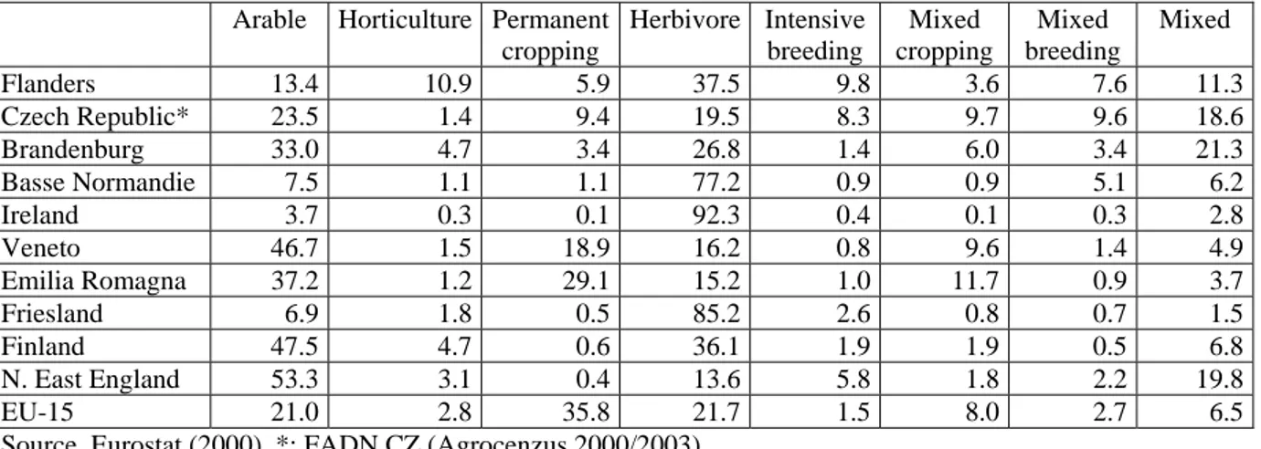
Table 8: Agricultural holdings by farm type (% of the total number)
Arable Horticulture Permanent cropping Herbivore Intensive breeding Mixed cropping Mixed breeding Mixed Flanders 13.4 10.9 5.9 37.5 9.8 3.6 7.6 11.3 Czech Republic* 23.5 1.4 9.4 19.5 8.3 9.7 9.6 18.6 Brandenburg 33.0 4.7 3.4 26.8 1.4 6.0 3.4 21.3 Basse Normandie 7.5 1.1 1.1 77.2 0.9 0.9 5.1 6.2 Ireland 3.7 0.3 0.1 92.3 0.4 0.1 0.3 2.8 Veneto 46.7 1.5 18.9 16.2 0.8 9.6 1.4 4.9 Emilia Romagna 37.2 1.2 29.1 15.2 1.0 11.7 0.9 3.7 Friesland 6.9 1.8 0.5 85.2 2.6 0.8 0.7 1.5 Finland 47.5 4.7 0.6 36.1 1.9 1.9 0.5 6.8 N. East England 53.3 3.1 0.4 13.6 5.8 1.8 2.2 19.8 EU-15 21.0 2.8 35.8 21.7 1.5 8.0 2.7 6.5
Source. Eurostat (2000), *: FADN CZ (Agrocenzus 2000/2003)
The predominance of cattle and sheep farming in Basse Normandie, Ireland and Friesland is illustrated by the proportion of herbivore farms (Table 8), which reflects land use (Table 4). There is similar distribution between arable, herbivore and mixed farms in Brandenburg and North East England, while there is more or less a balance between arable and herbivore farms in Finland. The distribution by farm types in Veneto and Emilia Romagna is dependent on their location, with a predominance of cattle and sheep farming in hilly part, and mainly arable and permanent crops on lowlands. The diversity of Flanders is illustrated by the distribution of holdings by farm type. Nevertheless there is a predominance of livestock farms (pigs, milk, cattle and poultry) as shown by the total of herbivore, intensive breeding, mixed breeding and mixed farms (66.2% of holdings). Otherwise, the proportion of horticultural farms (10.9%) partially reflects the crucial role of horticulture in Flanders.
Table 9: Main trend in farming
Flanders Conversion from arable farming into intensive horticulture Czech Republic Shift from commodities to non-market goods (multifunctionality) Brandenburg Shift from grain to forage and oilseed production
Basse Normandie Intensification and consolidation of farms towards arable crops Ireland Specialisation towards beef production
Veneto Quality products (wine, fruit, vegetable, cheese…) Emilia Romagna Quality products (wine, fruit, ham…)
Friesland Dairy and cattle farming on grassland Finland Shift from livestock farming to crop farming North East England Swing towards arable systems
Does foreseen trend in farming should strengthen current orientation (Table 9)? Given a limited availability of land, Flanders, Veneto and Emilia Romagna are likely to value their know how and good integration in the agri-food complex, and therefore to favour horticulture crops and the production of quality products. According to natural conditions, farm support and the structure of holdings the shift towards arable systems should continue in Basse Normandie and North East England, while the output mix should favour forage and oilseed production in Brandenburg. Nevertheless past trend could be dampened by the recent reform of the Common Agricultural Policy which did not favour grain production. Current specialisation towards beef production in Ireland and dairy farming in Friesland is likely to be reinforced. There is evidence of a new trade-off between the various agricultural outputs with a shift favouring amenities and green tourism in The Czech Republic. Finally, the trend in Finland should strengthen the current state with very large regional differences. The specialisation towards crop farming should continue in the most suitable areas of the country.
1.5 Overview of the selection
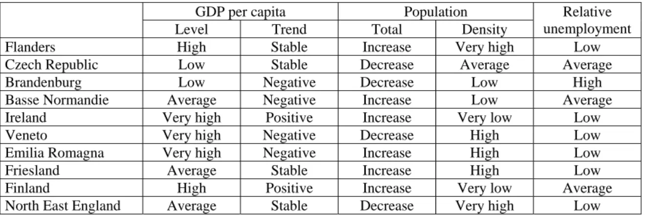
Sustainable development requires a firm economic and demographic basis. From this viewpoint, rural policy addresses a series of challenges including lower than average incomes, ageing population with risk of depopulation and great dependency on the primary sector. But there is evidence that these problems are not met throughout the selected case studies. Ireland is on the path of prosperity, while the group of prosperous regions including Veneto, Emilia Romagna and Finland, suffer either the detrimental effect of an ageing population or disequilibrium in the labour market (Table 10). In contrast Brandenburg concentrates a number of handicaps with a decreasing and ageing population, a low-income level, and a shortage of jobs. The other regions can be ranked along this scale; Flanders is close to the leading group, while Basse Normandie, Friesland and North East England define an average group. The Czech Republic is in between Brandenburg and this average group.
Table 10: Main economic and social indicators
GDP per capita Population
Level Trend Total Density Relative unemployment
Flanders High Stable Increase Very high Low
Czech Republic Low Stable Decrease Average Average
Brandenburg Low Negative Decrease Low High
Basse Normandie Average Negative Increase Low Average
Ireland Very high Positive Increase Very low Low
Veneto Very high Negative Decrease High Low
Emilia Romagna Very high Negative Increase High Low
Friesland Average Stable Increase High Low
Finland High Positive Increase Very low Average North East England Average Stable Decrease Very high Low
Note. Table 10 is based on Tables 2 and 3. GDP per capita categories are defined as follows: low is under 90, average is 90-110, high is 110-120 and very high is over 120 in 2000. Population density categories are as follows: very low is under 70, low is 70-100, average is 100-150, high is 150-250 and very high is over 250 in 2000. Relative unemployment categories are as follows: low is under 6.5, average is 6.5-10 and high is over 10 in 2003.
The appeal of rural areas for recreation and tourism is directly linked to the increase in income and the urbanisation process. Higher incomes encourage the demand for environmental quality, since they are accompanied by higher education, increasing the awareness of pollution and its harmful effects. For urban dwellers, a rural environment appears to support various opportunities to experience compensatory alternative surroundings and cultural or recreational activities. However, there is often tension between on the one hand rural and farming interests, and on the other hand tourists and visitors concerns. This is likely to result into conflicts between local stakeholders who benefit presumptive rights on the countryside and urban people who claim their own rights for recreational uses.
Table 11: Main agricultural indicators
Holding size Land use
Surface Economic
Trend in farming
Flanders Arable, urban Small Medium Horticulture Czech Republic Arable, forest Medium/large Small Non-market
goods Brandenburg Arable, forest Large Large Forage & oil
seeds Basse Normandie Grassland, arable Medium Small Arable
Ireland Grassland Medium Small Beef
Veneto Arable, forest Very small Very small Quality products Emilia Romagna Arable, forest Small Small Quality
products
Friesland Grassland Medium Large Dairy
Finland Forest Medium Small Arable
North East England Grassland, arable Large Medium Arable
Note. Table 11 is based on Tables 4, 5, 7 and 9. Holding surface categories are defined as follows: very small is under 10 ha, small is 10-25 ha, medium is 25-75 ha and large is over 75. Holding economic size categories are as follows: very small under 10 ESU, small is 10-30 ESU, medium is 30-75 ESU and large is over.
The diversity of land use, farm structure and economic size between regions must be emphasised (Table 11), while five main combinations of land use categories can been defined: mainly grassland (Ireland, Friesland),
grassland and arable (Basse Normandie, North East England), mainly forest (Finland),
arable and forest (Czech Republic, Brandenburg, Veneto, Emilia Romagna), arable and urban (Flanders),
there is evidence that within diversity is also significant, as shown by the following cases. Finland is the most forested country in Europe. In the whole country the arable areas are very scattered, and there are large uniform arable areas only in southern Finland as well as along certain rivers. Originally the Finnish farming land was cleared from forest, and almost all forest areas suited for farming have been turned into arable land. However, farming areas are very small and often located far away from each other, and thus it has been very difficult to establish efficient conditions for farming activities.
Most of Ireland is covered by agricultural land and pasture is the dominant agricultural land use. Livestock rearing for meat production and dairying are the predominant agricultural
activities. Agriculture in the western and northern parts of the country is generally less productive than in the eastern and southern parts.
In North East England, the proportion of land in arable cropping or set-aside has increased over the last ten years with a corresponding reduction in the area of temporary grassland and rough grazing reflecting a swing towards arable systems in lowland areas. However, there are significant intra-regional variations in dominant land cover. For example, the western areas of the region are dominated by poorer quality soils supporting upland and hill grassland, moorland and coniferous forestry. In some parts of the region, forestry is a particularly significant land use, for example approximately 20% of Tynedale district is afforested. The south, the eastern coastal plain and the far north of the region are mainly arable areas.
There are also important intra-regional differences in Emilia Romagna. Most of the plain along the Po River benefits a very good soil suitable for arable farming. Lowland was dried through long land reclamation and is likely to being converted back to wetlands. The hilly and mountain area provides outdoor recreational opportunities, while the coastal zone is oriented towards summer tourism. A similar diversity characterises Veneto, which extends from a coastal zone with very large wetlands up to high alpine range.
As summarised in Table 11, the trend towards a more specialised farming should continue in the next future. This should favour livestock farming in Ireland and Friesland, arable crops in Brandenburg, Basse Normandie, North East England, and horticultural crops in Flanders where the availability of land is lower. Established experience by selling traditional quality products is likely to influence the future evolution of farming in Veneto and Emilia Romagna, while there is evidence of a trend towards a more multifunctional agriculture in the Czech republic. However, the conversion of grassland into arable land should continue at a lower speed than in the past, and in addition could be stopped if strict requirements on the maintenance of grassland would be introduced in the next future.
2 Supply of AESs
2.1 Historical perspective
EU agri-environmental policy results from ideas and practices taken from different countries and has gradually expanded to an extent that is unique. Although, European legislation provides a precise and comprehensive framework, past experience with agriculture and the environment, environmental concerns, institutional arrangements and lobby strategies are very different over Europe.
In 1974 the Dutch Government made a significant entry into the field when it was decided to develop a regulation whose overall purpose was to improve the interface between agriculture and wildlife, and landscape. Reserve areas and management areas, in which agri-environmental schemes were proposed, have been designated. The policy instrument that emerged was the management agreement in which farmers make a six-year contract with the Government for maintaining and improving wildlife and landscape in designated areas. The British Government promoted the concept of Environmentally Sensitive Areas (ESA). ESAs are areas of landscape, conservation or archaeological interest where farmers are offered financial incentives to comply with a set of management practices designed to secure conservation objectives. In contrast to Belgium, France or Italy, the implementation in the UK has been very fast and farmers, which may be partly explained by the comparatively slight constraint they impose on the practices of many participants, have taken up agreements enthusiastically. Founder EU-members, such as Belgium, France, Italy, were not instrumental in securing the inclusion of agri-environmental provisions within EU legislation up to the 1992-CAP reform. Nevertheless, transposing European agri-environmental policy into national law and nominating national competent authorities was relatively straightforward. However, a number of differences emerged between countries resulting from significant differences related to the role of agriculture and concerns about the environment. Compared to some länder of the former West Germany, France was a late participant in agri-environmental programmes.
When new Members joined the EU in 1995, they had to put the acquis communautaire into effect at the national level. This has created a shift in agri-environmental policy as illustrated by the Finnish case. Indeed, Finland experienced an original way to deal with the interface between farming and the environment. Before entering the EU, agricultural administration and farmers’ union jointly designed agricultural policy, farmers being acknowledged as the best guardians of the countryside, the philosophy was to entrust them with the protection of the environment.
Despite the implementation of pre-accession schemes, a dramatic change in public policy should result from the last enlargement of the EU to Central and Eastern European countries. Related to agri-environmental programmes, this point is illustrated with the Czech Republic case. In 1994, the first agri-environmental programme offered subsidies for applying a series of specific measures, but unfortunately, this programme suffered a number of drawbacks. The installation of the Czech Republic agrarian policy for the 1999-2003 pre-accession period put emphasis on agri-environmental issues. It defined the first fully compatible measures with EU legislation.
2.2 Environmental assets
Because farming and forestry occupy so much of the rural territory, their role in managing rural space and shaping the rural landscape is fundamental. The potential contribution of tourism to rural economics development is acknowledged and encouraged by the AESs. But such tourism needs a provision of environmental goods, which are supported by the maintenance of environmental assets including water body networks, a mosaic of landscapes and habitats.
Land use patterns have gradually settled into a few major categories: urbanised areas, farmland where areas of intensive farming are juxtaposed with marginal areas and forests. Farming is important for the upkeep of land in a number of areas with natural and physical handicaps such as less favoured areas and mountain areas, as well as areas of particular environmental relevance such as Natura 2000 sites. Indeed, agriculture maintains a significant share of the diversity of plant and animal species. It has created diversified environments, which provide suitable habitats for a wide range of species. Plants and animals that favour these semi-natural habitats constitute a considerable share of species in most rural areas. Mountain areas are objectively defined by altitude or steep slopes, and extend over an important portion of Veneto, Emilia Romagna and Finland (Table 12). Otherwise, mountain areas are also under the less favoured area heading. Less favoured areas are designated by a mix of economic, social and environmental conditions, among which a poor economic situation and a danger of depopulation are required to define a large zone. Small areas affected by specific handicaps can be also designated. However, there has been some uncertainty about the precise nature of specific handicaps. All regions, except Flanders and Friesland, include less favoured areas.
As expected, regarding the general context, less favoured areas extend over a large part of Brandenburg (Table 12). They sum to more than half of agricultural land in Ireland and North East England, one-fourth in Basse Normandie, and one-fifth of non-mountainous agricultural land in Finland. This is a clear indication of the persistence of internal disparities that are only partly due to adverse natural conditions.
Table 12: Areas under specific designations
Natura 2000 on farmland
Mountain areas
% of UAA
LFA
% of UAA % of all sites % of UAA
Flanders 0.0 0.0 2.4 0.1 Czech Republic* 12.5 59.4 na 2.6 Brandenburg 0.0 74.8 29.0 6.5 Basse Normandie 0.0 23.6 22.5 1.0 Ireland 0.0 52.4 27.9 3.2 Veneto 15.5 31.1 28.2 11.3 Emilia Romagna 22.1 26.7 4.4 0.7 Friesland 0.0 0.0 9.4 1.2 Finland 51.9 72.6 15.2 29.9
North East England 0.0 56.9 51.4 7.2
EU-15 17.9 54.8 na na
Sources. Eurostat (2000), European Environment agency, June 2003 *: Green report of the state of Czech agriculture 2000, MoA
Most Natura 2000 sites require active management to maintain their conservation value, especially on farmland. The proportion of sites located on agricultural land ranges from 2.4% in Flanders to 51.4% in North East England (Table 12). These areas still account for a significant proportion of agricultural land in Brandenburg (6.5%) and North East England (7.2%), and are about 30% in Finland. Despite a series of delays in the designation of Natura 2000 sites in many places, the network is likely to grow in the next future. The location of sites on farmland will give farmers an opportunity to attract an additional financial support whose total amount could be significant. Up to now, this strategy has been successfully applied in several case studies.
For many rural communities new employment opportunities in recreation and tourism are offsetting the loss of employment in agriculture and forestry. Finland provides a relevant case of rural development based on the environment considered as a rural resource. Rural tourism started in Finland in the beginning of the 20th century, when boarding houses were established in connection with farms. Farm holidays were rediscovered a little more than thirty years ago, when efforts started to be made to obtain additional income to farms from farm holidays and renting of cottages. At present there are about 2100 enterprises offering rural holiday services and the number of bed places totals 45,000. Most of the rural tourism enterprises are relatively young, and the average age of the enterprises is only twelve years. In general forecasts indicate that the demand for rural and wildlife tourism services produced in small family companies should grow in the future.
The fact that the countryside is more and more popular is observable all over the EU. This evolution favours a diversification of rural economies and should provide new job opportunities to rural people. The existence of outstanding environmental assets such as wetlands, landscapes, shorelines offer good prospects for tourism (Table 13). Indeed, traditional countryside has been moulded by farmers’ activities over the years and is considered to be beautiful and attractive. Otherwise, the duty of sustainability is to bequeath to posterity unique assets such as the Wadden zee in Friesland, the Spreewald region in Brandenburg, Ramsar sites in Basse Normandie or forest and water resources in Finland. However, the combination of more common natural assets having substitutes, with the
proximity of urban areas is also a positive factor for both marketing regional products and expanding tourism. Each case study provides such examples of success stories based on one-day visits or short stays, during which visitors may experience outdoor activities (hiking, hunting, angling) the local food or enjoy a quiet environment.
Table 13: Outstanding environmental assets
Flanders Bocage Wetlands
Coastal zone (66 km) Czech Republic Wetlands
Meadows with a diversity of species Valuable landscape in mountainous areas Wildlife & habitats
Brandenburg Moors (36 000 ha) Wetlands (12 300 ha)
Beautiful & attractive landscape Basse Normandie Bocage (95 000 ha)
Wetlands (25 000 ha) Coastal zone (470 km) Ireland High water quality
Countryside of high biodiversity Beautiful & attractive landscape Veneto Wetlands (25 850 ha)
Forestland (211 603-351 000 ha) Coastal zone (170 km)
Emilia Romagna Bocage Wetlands
Coastal zone (120 km) Friesland Wetlands
Wildlife & agricultural landscape Network of canals, small rivers & lakes Wadden zee
Finland Very large water resource Forestland
North East England Two National Parks
Two areas of Outstanding National Beauty Two heritage coastlines
Two UNESCO World Heritage Sites
2.3 Pressure on the environment
2.3.1 OverviewRegarding cropping patterns, the most significant aspect for the environment is the shift from permanent grassland to arable land associated with the development of monoculture. This has created a monotonous landscape which most people do not find attractive, and high land-use intensity with its consequences: threat of erosion, water damage, destruction of biotopes and loss of biodiversity. Intensification and specialisation have come about through major structural changes involving a rapid increase in the average holding and the substitution of machines for labour. The ever-increasing size and power of machines used on arable land led
to soil compaction and erosion. It called for wider plots, which were obtained through land amalgamation or plot consolidation.
Comparable developments have taken place in the livestock sector characterised by a dramatic increase in intensive animal husbandry, notably pigs and poultry. Local effects of this intensive farming concern visual amenity since high-quality rural landscapes are damaged by the erection of grain silos and modern agricultural buildings for animals. Moreover the quantity of manure, combined with the other sources of nutrients, caused large quantities of nitrates and phosphorous to run off into rivers or aquifers.
Some available indicators give an overview of farming pressure on the environment. They estimate intensification either through total output per hectare2 or through the quantity of
nitrogen applied per hectare (Table 14). The surplus of nitrogen, because it takes into account the crop mix, is a better indicator of pollution than the application.
Table 14 :Agricultural intensification
Nitrogen (kg/ha) ESU/ha
Mineral Organic Surplus
Green forage on arable land (%) Flanders 3.4 108 322 233 40.4 Czech Republic na 59* na na 23.4 Brandenburg 0.6 91 37 85 14.6 Basse Normandie 0.9 76 78 33 43.1 Ireland 0.7 81 99 16 1.6 Veneto 0.7 57 60 15 13.0 Emilia Romagna 2.0 201 180 195 36.6 Friesland 2.8 81 39 56 45.9 Finland 0.8 77 82 24 32.1
North East England 0.5 91 37 85 16.3
EU-15 1.0 na na na 19.5
Source. Eurostat, * WP3 P9 DR 01
2.3.2 Main pressures
Regarding these simplified indicators, regions have contrasted average profiles. The most serious environmental stress should concern Flanders that faces a critical soil and water pollution, which are exacerbated by a big manure problem and urbanisation. There is a similar picture in lowlands of Veneto and Emilia Romagna, while highlands are threatened by land abandonment. It is interesting to compare these two regions with Friesland where output per hectare is similar but average nitrogen surplus is significantly lower.
Intensification is relatively moderate in the other areas. Nevertheless, Ireland, Finland and Basse Normandie should be distinguished from Brandenburg and North East England with respect to fertiliser use. Despite significant differences in average levels of intensification, there are high spots of water pollution everywhere. Thus the overload of nutrients is the most reported threat to water resources (Table 15).
The agricultural landscape has a high degree of variety, even if the trend is towards more grain production on bigger fields with fewer interruptions. Otherwise, the development of consolidation of holdings has changed the character of grassland and led to a reduction in the area suitable for breeding birds. This trend affects both scenic and biological variety and is ranked as the second major threat.
Table 15: Most significant pressures
(ranked by decreasing order)
Flanders
1. Water pollution (nitrates & pesticides) 2. Intensive energy use (horticulture) 3. Acidification
4. Air pollution (greenhouse gasses)
Czech Republic
1. Biodiversity & landscape loss (land abandonment in mountainous areas with a valuable environment)
1. Water pollution
1. Soil erosion (mountainous areas) 1. Flood (mountainous areas) Brandenburg
1. Biodiversity loss 2. Water pollution 3. Soil erosion
Basse Normandie
1. Biodiversity & landscape loss (conversion of grassland, drainage & abandonment of wetlands, destruction of hedgerows)
2. Water pollution (nitrates) 3. Soil erosion
4. Flood (sea tides, urbanisation) Ireland
1. Water pollution (nitrates & sediments) 2. Biodiversity loss
3. Air pollution (greenhouse gasses & ammonia concentration) 4. Soil erosion (overgrazing on hillsides)
Veneto
1. Water pollution (nitrates in lowlands)
2. Biodiversity & landscape loss (conversion of grassland, drainage of wetlands, destruction of hedgerows)
3. Soil erosion (mountainous areas) 4. Flood (mountainous areas)
Emilia Romagna
1. Water pollution (nitrates)
2. Food & environmental contamination (pesticides)
3. Biodiversity & landscape loss (destruction of hedgerows & tree rows)
4. Flood
5. Soil erosion (uplands and hills) 6. Air pollution (greenhouse gasses) Friesland 1. Water pollution (nitrates)
1. Biodiversity & landscape loss Finland
1. Water pollution (nitrates & phosphorus)
1. Biodiversity & landscape loss (land abandonment in the north & intensification in the east & south)
North East England
1. Water pollution
1. Biodiversity & landscape loss 1 Threat to historic features 1. Soil erosion
The destruction of hedgerows, the conversion of grassland to arable land combined with the drainage of wetlands led to adverse effects on the landscape and biodiversity loss in several case studies, among which Basse Normandie, Veneto and Emilia Romagna. Cultural
landscapes are the result of centuries-old human use and are very much appreciated by tourists and countryside lovers because of diversity of the habitats and scenery. They are associated with traditional agriculture based on pastures and low-input farming. Land abandonment in mountainous areas (e.g. in the Czech Republic) or in remote areas (e.g. in Finland) results into the conversion of low productivity land into forest leading to habitat destruction. There is also some concern about the cultural and historical inheritance attached to traditional countryside (e.g. North East England and Basse Normandie).
Land degradation may result from several sources including soil compaction, wind and water erosion. Due to the sandy composition of soils, all arable land in Brandenburg is potentially prone to wind erosion. There is evidence of erosion of arable land due to unsuitable practices in the Czech Republic and Basse Normandie, while erosion is associated with overgrazing on hillsides in Ireland. Erosion creates a number of offside detrimental effects including a load of sediments in rivers, canals and water pipes. Otherwise, the risk of flood is reported in mountainous areas in the Czech Republic, Veneto and Emilia Romagna. It may result either from land abandonment or from a poor maintenance of farmland and forestland as well as urbanisation. It is also mentioned in Basse Normandie where it is due either to urbanisation or to the combination of high tides and wind. However in Basse Normandie, this latter source of risk is under control for decades thanks to civil engineering.
Air pollution from the emission of greenhouse gases especially ammonia, is only mentioned in Flanders, Ireland and Emilia Romagna. It leads to negative externalities through acid deposition but off-farm sites. Finally pesticide contamination (Emilia Romagna) and intensive use of energy (Flanders) are also reported.
The ranking of environmental priorities may vary according to the evaluator as shown by the Basse Normandie case. According to the agricultural administration, water quality is the most challenging issue, whereas scientific experts, who rely on a comparison with other French regions, consider that the protection of biodiversity should have the highest rank.
2.3.3 Environmental pressures and policy objectives
Policies target environmental objectives, which are consistent with the most significant pressures. However landscape and biodiversity protection are often viewed as a secondary objective, which should be achieved either through the maintenance of farming or the protection of water resources.
In the Czech Republic the 1990’s transition has been associated with a diminution of the environmental pressure because of an extensification process, and problems occurring because of land abandonment. In Central Moravia land abandonment is a crucial issue to deal with in mountainous areas, which benefit a valuable environment whose richness is, threaten by a risk of loss in biodiversity and landscapes. A global deterioration of soils also occurred from water and wind erosion, thanks to the destruction of hedgerows and small woodlands, as well as soil compaction because of improper mechanisation. Northern and Eastern Finland face a similar challenge, a dramatic land abandonment increase leading to a degradation of biodiversity and landscape. In other places, located in the south and west of the country water eutrophication because of an increasing use of nitrogen and phosphorus is the most challenging objective. Policies applied in Emilia Romagna primarily address water pollution due to an over-use of nitrates and pesticides, and land abandonment.
Otherwise the protection of water resources is the leading policy objective. For instance, the Irish Environmental Protection Agency held agriculture responsible for the majority of fresh water eutrophication. However, in addition the decline of the species and habitat diversity has also been attributed to agriculture. In Veneto, the water issue is particularly challenging because of pollution of highly valuable tourist spots such as the Venice Lagoon where there are catchment basin specific problems. Being a rather close lagoon with a limited water recharge, pollutants (nitrates, phosphates, heavy metals) accumulate on the sea bottom. This leads to very severe pollution and eutrophication problems. Hence this area is specifically monitored. Water pollution is also a main priority for Brandenburg, North East England and Flanders.
The protection of historical landscapes such as hedgerows in Basse Normandie, Emilia Romagna and Veneto, and walls in North East England is also targeted. The protection of meadow birds may be also a first policy objective as illustrated by Friesland.
2.4 Menu of AESs
2.4.1 Hierarchical systemsIreland and Finland combine a compulsory menu of prescriptions and voluntary schemes. Obligatory measures are a means to give farmers an additional income support and are close to a cross compliance approach.
In Ireland, basic measures have to be applied by farmers in order to be eligible to supplementary measures. The menu of measures proposed to farmers was initiated in 1994 with the Rural Environment Protection Scheme (REPS). In 2000, modifications were proposed to shift from REPS1-contracts to REPS2-contracts. In 2004, REPS3 was implemented in order to enhance measure uptake. This scheme is proposed to all farmers whose holding is over three hectares. REPS-prescriptions apply to the whole farm. It includes twelve basic measures, which are compulsory and supplementary measures, which are optional. Most measures were already proposed in previous REPS. Some basic measures target specific national issues such as water pollution, or species and habitat maintenance. Some specific measures are restricted to particular areas.
There is a similar situation in Finland where the agri-environmental programme combines a General Protection Scheme targeting all farmers and a Supplementary Protection Scheme, which includes more specialised and effective measures targeting voluntary farmers. The former scheme proposes basic and additional measures. Basic measures are designed to secure the implementation of AESs in the whole country (as basic fertilisation levels of arable crops or maintaining biodiversity and landscape), while additional measures take into account special conditions of different types of farms. Farmers have to apply basic measures but select additional ones according to farm types. Thus accurate fertilisation measure is offered to crop farms whereas promoting animal welfare is for livestock farms. Once the General Protection Scheme is implemented, farmers can also choose measures in the Supplementary Protection Scheme. Basic measures are applied on the whole farm, whereas additional and special measures are applied only on specific parcels.
2.4.2 Environmental and topographical targeting
Zoning is used in most other regions. According to holding location, farmers can apply to one or several schemes or measures. This situation concerns all schemes in the region or a mix is available with measures proposed to all farmers and specific one reserved to farmers in specific areas. For example, environmental characteristics are used to target sensitive areas where farmers are eligible to specific schemes, other schemes being proposed to farmers who have no parcel in these areas.
In North East England, as in the whole England, the Countryside Stewardship Scheme and the Environmental Sensitive Area Scheme are offered. In North East England the Pennine Dales is the only Environmental Sensitive Area. Contracts are related to the management of a variety of landscape (including reversion to grassland, managing meadows and pastures, managing all other grasslands, managing moorland and around, establishing and maintaining grass margins) in specific areas. All farmers who are not eligible to the Environmental Sensitive Area scheme can benefit the Countryside Stewardship Scheme, which concerns similar practices regarding the management of a variety of landscape types. This scheme also includes measure dealing with planting and restoring hedgerows, fencing, restoring dry stones walls. The evaluation of these schemes in 2002 led England to propose an unified national scheme ‘Environmental Stewardship Scheme’ combining existing schemes. According to farmer choice and motivation, different levels are available. This scheme will be available from 2005.
In Friesland, many different types of wildlife and landscape management are available to farmers. The province of Friesland has developed ten regional plans. These plans deal with sub-plans among which there are: landscape area, management area and problem area. Each area is meant for AES focusing respectively on landscape, wildlife management, and less favoured areas. Schemes are offered to farmers who wish to contract according to the belonging of his land and to the regional plan. In total about thirty AESs are available. Protection of meadow birds has an important place in AES design, because interest for these birds has been part of the Frisian culture for a long time. In 1993 a new policy instrument was proposed. Contracts not attached to a specific designated area were available to farmers. Initially, the objective of combination of agriculture and protection of birds, botanical objectives and landscape elements was formulated. After different steps, free contracts were accepted and can be used for about 8000 ha all over the province. Free contracts are not free in their design but with respect to their location. A better term would be location free contracts. Compared to the traditional policy in the Netherlands, these contracts aim at increasing the number of farmers seeing results of meadow bird’s protection in Friesland. In Emilia-Romagna, there is a strong commitment to environmental issues and environmental norms were implemented very fast. The Rural Development Programme comprises eleven measures which have been designed to fulfil with the objectives of the European RDP. They especially focus the abatement of polluting substances and the provision of positive environmental services (landscape, biodiversity..). Eligibility rules are based on a topographical zoning that distinguishes land in plains, hills or mountains. In addition, there are ‘agri-environmental agreements’ targeting areas where relevant environmental problems exist. In selection of applicants, priorities are given to such farmers whose parcels belong to areas involved in agri-environmental agreements.
In the Czech Republic, the SAPARD environmental schemes were based on a zoning approach. Indeed, five pilot areas with specific priorities were selected to implement agri-environmental measures. Proposed measures had quantified objectives adapted to the environmental priorities of each pilot area. In the HRDP, three main measures have been maintained: organic farming, grassland maintenance, and conversion of arable land to grassland. In 2004 new measures were introduced.
In Veneto the RDP was implemented through a series of calls in which agri-environmental measures were proposed to farmers. The first call, including all measures, was launched in 2000, while the two followings were restricted to a limited number of measures because of budget cut. The likely positive landscape and environmental impact has been considered to select the two following measures: ‘Conservation and restoration of meadows and pastures in hills and mountains’ and ‘Buffer strips’. The 2003 call was reduced to a single measure: ‘Conservation of threatened vegetal breeds’, while the 2004-call is based on a new measure: ‘Animal welfare and energy from renewable sources’. Designation of the targeted areas is the most important point related to eligibility. For example, measures favouring wildlife and the conservation of permanent meadows are allowed only in flatland, while those for establishing buffer strips and hedgerows are allowed in hilly or flat area. Regarding applicants, preference is given to farmers belonging for some actions to groups of farmers having contiguous land and applying for the same action together in aggregated participation. This interesting point is specific to the Veneto region. Preferences also favour farmers who combine several actions. The idea here is to enhance effects of the single action to obtain positive synergies.
2.4.3 Towards more complexity
The combination of measures offered to most farmers with different types of zoning can lead to more complex situation as illustrated by Flanders and Brandenburg. The attempt to integrate a number of different objectives may finally result into a disorderly implementation as shown by the French case.
In Flanders, there is a combination of measures offered to a large population of farmers with some measures targeting a geographical area. For instance, zoning is used for the management of meadow birds and the management of field edges. It is also considered in the context of water management to define vulnerable areas where specific measures for reducing fertiliser application are applied.
In Brandenburg, there are four schemes of interest. First of all, the Cultural Landscape Programme (KULAP) includes sixteen measures targeting grassland management, arable land with plant protection, preservation of genetic diversity and extensive pond management. This programme is rooted in a set of extensification measures applied since 1992. The KULAP programme originated in 1994 and has been slightly modified to shift to the current KULAP-2000, which will cover the period 2000-2006. While all farmers are eligible, the KULAP does not offer a free menu since some measure are not compatible. A second programme includes a set of seven measures related to restrictions on farming in designated area for flora, fauna and habitat protection. This programme, based on Article 16 of 1257/99, is applied since 2000. The third programme is run under Article 20 since 2000 in the Spreewald area. It continues previous measures aiming at maintaining cultivation on the small fields and pastures in order to support traditional agricultural practices and therefore to ensure the economic basis of the
Spreewald area which is tourism oriented. Since Brandenburg is an Objective 1 region, these three programmes are co-financed up to 75% by the EU, while the fourth programme is supported by Brandenburg only. This is the contractual nature conservation programme, which originated in 1991 under the Brandenburg nature protection law and is offered mainly in designated areas. It has been refocused to avoid overlapping with the KULAP and it now predominantly targets landscape maintenance.
In France the situation is much more complex under Regulation 1257/99. Specific agri-environmental actions could be included in the territorial and agri-environmental part of the CTE (Farming Territorial Contract). In Basse Normandie, a hundred measures were initially proposed to farmers. To apply for CTE farmers had to draw up a farm diagnosis and to design a global farming project. According to the CTE approach, farmers could opt either for an individual strategy integrating the economic and environmental farming, or a territorial strategy aiming at common objectives. CTEs suffered a number of drawbacks including the complexity of procedures, the questionable environmental efficiency of many measures and the multiplicity of eligibility conditions. In addition, uptake remained lower than expected by the Government, while public administrative costs were uncontrolled. Despite the introduction of CTEs, some former agri-environmental actions were still offered to farmers, but with compensation down compared to the CTE scheme. Practical difficulties, as well as political change led to a shift towards the CAD (Sustainable Farm Contract) in 2003. This new contract is based on a more territorially focused approach and proposed a limited number of measures. Otherwise, the grassland premium scheme was renewed into the grazing agro-environmental scheme in 2003, which benefited a 70% increase of the premium. Eligibility rules and premiums vary across NUTS3 levels in Basse Normandie.
2.5 Organisational specificities
2.5.1 Involvement of local actorsA first element of organisational specificities is related to the involvement of regional and local people. Their active participation in AESs design and implementation may lead to a better fit to local conditions. While in Ireland REPS have been defined by the Ministry of Agriculture, REPS1 was designed after consultation with stakeholders interested in environmental protection and with farming organisations. In Finland, the involvement of lots of actors at the design step must be emphasised. Nearly one hundred actors from regional to local level administrations, interest groups, and professional organisation commented the draft version of the agri-environmental programme.
In Italy, rural development programmes have been set up at the regional level. Regarding Emilia Romagna, several aspects have to be specified. Farmers’ organisations are strongly connected to the territory and deeply influence the policy process. Different organisations, including associations and particularly numerous cooperatives play a significant role in agricultural policy and programming. Formal and informal links were important in the design of AESs in Emilia Romagna. But, provinces are free to organise the implementation and selection for payments. Payments are attributed to measures per province authorities. In the whole region, regional guidelines apply to identify priorities in order to allocate economic support. Until 2003 priorities were ranked as following: participation to ‘agri-environmental agreement’ (i.e. agreement with the objective of targeting applications in the areas where relevant environmental problems exist), localisation of the surface interested in the scheme,
typology of action subscribed, age of farmer applying, continuity with previous contracts. This classification leads to a score system. The territorial level can establish additional scores (based on range of coefficients established by regional authorities) in order to guarantee that AES have the highest expected environmental effectiveness through radical change in farm management practices. For instance priorities can be: crop change, destination of farmland, localisation of the surface in more areas with higher potential environmental impact. Since 2003, two actions, ‘conservation of set-aside’ and ‘recreation and maintenance of natural and semi-natural spaces and landscapes’ are now on the top of the agenda. AESs favouring ‘agri-environmental agreements’ and giving an additional support to farm priority areas integrate territorial and environmental specificities.
Veneto region has a good and efficient administrative structure in the agriculture and forestry sector and benefits since the early 1970s a specific structure in its mountainous part. There are mountain communities in charge of physical planning, including land use. They are therefore the main actors of the conservation of landscape patterns of those areas. Farmer communities and environmental organisations are the second major players in the agricultural, forestry and environmental policy game.
The new established regional development agency in North East England thanks to the process of decentralisation of administrative structures has to be mentioned. But various environmental NGOs are among the most important lobby group shaping rural policy and therefore are involved the AESs process. As in whole England, there are steering and working groups for the implementation, evaluation and review of AESs. All these groups help to ensure some strategic overview of the AESs included in the England Rural Development Programme (ERDP) at national and regional levels. Especially, regional programming groups brought a new approach and provided a useful forum, giving organisations a chance to meet and network with other agencies. However, many stakeholders were not convinced by the real power of this group to influence strategy. Another group called regional consultation group was implemented. For the Department for Environment Food and Rural Affairs, this group was a way to enable networking and to test out ideas. For stakeholders, this group was greatly criticised because it was seen more as a ‘talking shop’, less practical than a real workshop. In North East England the regional branch of the rural development service worked on the ERDP, with the help of the Regional Programming Group.
The complex institutional setting of Flanders results from the long transformation of Belgium into a federal state. Regarding AES responsibilities, the initial national Belgian plan contained two measures: organic farming and integrated fruit production, which were divided between the Walloon region and Flanders in 2003. Regional administrations have a key role in the initiation and implementation of AESs. The Flemish RDP was initiated through an agricultural conference. Pressure groups such as farmer organisations, local policy makers, and environmental groups were invited and could make suggestions on the plan priorities. AESs were initially presented by administrations and then proposals of the pressure groups were integrated. Study groups were initiated in order to work out prescriptions for new AESs. EU funding is allocated by the Belgium state to the Walloon and Flemish regions through a political decision-making.
In Friesland, most local actors take part to the implementation of AESs, however the leading role of environmental co-operatives in tailoring measures to the local context has to be emphasised. Many groups of volunteers are also active in protecting wildlife and landscapes influencing agricultural wildlife and landscape management. For instance they take care of
birds, they count birds for research aims. Before 2004, environmental cooperatives could receive the financial compensation directly. Farmers were paid by co-operatives on the base of their wildlife and landscape management and results of the management. Since 2004, in order to comply with EU legislation, farmers receive compensation directly. But as a contracting partner in a collective contract, farmers pay a part of their subsidies to co-operatives and they can get their money back depending on their management and results. The role of the EU as restrictive factors in AES implementation possibilities is to notice. The change occurred in the role of environmental cooperative is a good example of this point. However, the Dutch ministry launched experiments on wildlife and landscape management in order to gain experience with the design of AESs. These experiments were used within the policy design. Environmental co-operatives made the same initiatives, as the geese protection in Friesland.
2.5.2 Institution and implementation
In Germany, the rural development plan is proposed at the land level (NUTS1). Brandenburg is one of the new German länder and has therefore a particular situation since it was submitted to frequent and substantial reforms in its administrative structures. In 2004, a reform of the agricultural and environmental administration took place.
The Czech Republic has only recently implemented agri-environmental measures. However it gained some experience with schemes designed and implemented in rather centralised way under the Government Decree 505 issued in 2000. The process differed with the agri-environmental component of SAPARD that was applied to five pilot areas. Meanwhile there was non-governmental initiative with international support involving several environmental NGOs in a consortium, to prepare schemes. Quite pragmatically, the SAPARD Agency adopted the proposal of schemes in the full extent as prepared by the non-governmental initiative. Some experts from the consortium were asked to participate during official negotiations with the EU and defend the proposal. The consultation process of SAPARD was delayed, and particularly the approval of AESs came quite late, thus there was not sufficient time to undertake a massive information campaign among farmers. But short time available to the implementation led to failures explaining a low uptake in several pilot areas. But SAPARD introduced a specific cooperation of the Ministry of Agriculture with other authorities. The process of decentralisation of the state administration started in 2001, when regions (NUTS3) and regional self-governments were introduced. However, the rural development programme for the period 2004-2006 (HRDP) including all previous schemes, has been developed, designed and implemented at the national level. The convincing success of SAPARD, led the Ministry of Agriculture and the Ministry of the Environment to have cooperative meetings to elaborate AESs of HRDP even if they had different aims. The Ministry of Agriculture wants less targeted measures with significant income effect, while the Ministry of the Environment wants to maximise environmental benefits. But they globally understand the potential importance of these measures regarding environmental impacts and European subventions possibilities. Farmers unions were involved in the consultations with the Ministry of Agriculture. But these associations, as other professional ones, did not recognise the same importance to AES than ministries.
In France the situation is rather complex and some specificities are important to note. The shift from Regulation 2078/92 to Regulation 1275/99 involved a stronger input of farmers’ organisations. Otherwise, the participation of environmental and other non-agricultural