Métallogénie du gîte d’or orogénique La Pointe au
contact entre les sous-provinces de La Grande et
d’Opinaca, Eeyou Istchee Baie-James, Québec
Mémoire
Jean-Philippe Fleury
Maîtrise interuniversitaire en sciences de la Terre - avec mémoire
Maître ès sciences (M. Sc.)
Québec, Canada
Métallogénie du gîte d’or orogénique La
Pointe au contact entre les sous-provinces
de La Grande et d’Opinaca, Eeyou Istchee
Baie-James, Québec
Mémoire
Jean-Philippe Fleury
Sous la direction de :
Georges Beaudoin, directeur recherche
Carl Guilmette, codirecteur de recherche
ii
Résumé
Le gîte
d’or orogénique La Pointe est encaissé dans des roches archéennes au contact
entre les sous-provinces de La Grande et d’Opinaca, dans le territoire municipale d’Eeyou
Istchee Baie-James, Québec. L’assemblage lithologique, intensément déformé et
métamorphisé au faciès des amphibolites, comprend une tonalite du Complexe de Langelier
(3326 ± 4 Ma), une arénite quartzitique de la Formation d’Apple, des amphibolites et une
formation de fer appartenant au Groupe de Yasinski, et des paragneiss du Complexe de
Laguiche. Cet assemblage est coupé par des dykes felsiques (2747 ± 2 Ma), des
filons-couches ultramafiques et des dykes granitiques à tourmaline. La Zone 25 est encaissée
dans des paragneiss et comprend de l’or disséminé associé avec de l’arsénopyrite, de la
pyrrhotite et de la chalcopyrite. La zone minéralisée est orientée ONO-ESE (S
1) et est
déformée et plissé par une schistosité régionale principale (S
2). La minéralisation est
accompagnée de zones d’altérations recristallisées formées de quartz, de phlogopite, de
dravite ± titanite, de microcline et de muscovite, ainsi que des veines calco-silicatée. L’or
natif forme des inclusions dans l’assemblage recuit durant le métamorphisme ou forme des
grains en bordure des sulfures.
La faible teneur en or de l’arsénopyrite suggère qu’une
rééquilibration à plus haute température a libéré
l’or de l’arsénopyrite. La Zone 26,
encaissée dans une formation de fer, est caractérisée par un remplacement par des sulfures
comprenant de la pyrrhotite, de l’arsénopyrite, de la löllingite et de la chalcopyrite. Le
remplacement est accompagné par des zones à amphibole
calcique-biotite-grenat-tourmaline±chlorite. L’or natif est en inclusions dans les minéraux métamorphiques, ou bien
à l’interface entre des cœurs de löllingite dans l’arsénopyrite, suggérant qu’une partie de l’or
a été libéré lors d’un métamorphisme rétrograde. Le gîte La Pointe est interprété comme
étant une gîte d’or orogénique de type disséminé, d’origine pré-métamorphique, ayant été
subséquemment affecté par un métamorphisme régional au faciès des amphibolites et un
métamorphisme rétrograde postérieur.
iii
Abstract
The La Pointe gold deposit is hosted in Archean rocks metamorphosed to amphibolite facies
straddling the boundary between the La Grande and Opinaca subprovinces, in Eeyou
Istchee Baie-James, Québec. The lithological assemblage comprises a tonalite of the
Langelier Complex (3326 ± 4 Ma), quartz arenite from the Apple Formation, amphibolite and
iron formation from the Yasinski Group, and paragneiss from the Laguiche Complex. These
rocks are cut by felsic dykes (2747 ± 2 Ma), ultramafic sills and pegmatitic granite dykes.
The La Pointe deposit is defined in two zones, Zone 25 and Zone 26. Zone 25 is hosted in
biotite-rich paragneiss and the mineralization consists of disseminated native gold along
with arsenopyrite, pyrrhotite, chalcopyrite and minor pyrite. The deposit is oriented
WNW-ESE (S
1) and has been deformed and folded by the main regional deformation (S
2). The
mineralization is associated with recrystallized alterations consisting of quartz, phlogopite,
dravite ± titanite, microcline, muscovite and calco-silicates veins. Native gold occurs as
inclusions in the annealed metamorphic assemblages and at the margin of arsenopyrite.
The low content of gold in arsenopyrite suggests re-equilibration at peak condition during
arsenopyrite recrystallization which caused gold exsolution. Zone 26 is hosted in an iron
formation characterized by replacement by sulfides, consisting of
pyrrhotite-arsenopyrite-löllingite-chalcopyrite. The replacement is accompanied by calcic
amphibole-biotite-garnet-tourmaline ± chlorite. Native gold occurs as inclusions in peak metamorphic minerals, or at
the interface between löllingite core and arsenopyrite. The La Pointe deposit is interpreted
as a disseminated, pre-peak metamorphism orogenic gold deposit, subsequently
overprinted by later higher, amphibolite-grade, and late retrograde metamorphism. This
study provide new hints on understanding hypozonal lode gold deposits with regard to the
timing of mineralization in relation to their complex tectonometamorphic history.
iv
Table des matières
Résumé ... ii
Abstract ... iii
Table des matières ... iv
Liste des figures ... vi
Liste des tableaux ... vi
Liste des abréviations ... vii
Avant-propos ... viii
Introduction ... 1
Contexte ... 2
Objectifs ... 2
Géologie régionale ... 4
Présentation de l’article ... 6
Chapitre 1. The La Pointe gold deposit, a disseminated orogenic gold deposit at the
contact between the La Grande and Opinaca subprovinces, Eeyou Istchee Baie-James,
Québec ... 8
1.1 Résumé ... 8
1.2 Abstract ... 9
1.3 Introduction ... 10
1.4 Regional geology ... 12
1.5 Deposit geology ... 14
1.5.1 Supracrustal rocks ... 17
1.5.2 Intrusive rocks ... 19
1.6 Analytical methods ... 20
1.6.1 Lithogeochemistry ... 20
1.6.2 Electronic Probe Micro-Analysis ... 20
1.6.3 LA-ICP-MS ... 21
1.6.4 MicroXRF ... 21
1.6.5 U-Pb geochronology ... 21
1.7 Mineralization ... 22
1.7.1 Zone 25 ... 22
1.7.2 Alteration assemblage ... 25
1.7.3 Zone 26 ... 27
1.8 Analytical results ... 30
1.8.1 Lithogeochemistry ... 30
1.8.2 Alteration chemistry ... 35
v
1.8.3 Mineral chemistry ... 37
1.8.4 Trace elements in arsenopyrite (LA-ICP-MS) ... 41
1.8.5 Geochronology ... 44
1.9 Discussion ... 49
1.9.1 Geological setting of rocks hosting the La Pointe deposit ... 49
1.9.2 Timing of mineralization ... 50
1.9.3 Gold in arsenopyrite ... 50
1.9.4 Hydrothermal alteration ... 52
1.9.5 Comparison with other amphibolite facies orogenic gold deposits and regional
implication ... 54
1.10 Conclusion ... 56
Conclusion ... 58
Bibliographie ... 60
Annexe 1 – Tableau des échantillons choisis ... 71
Annexe 2 – Résultats d’analyses lithogéochimiques des roches du secteur du gîte d’or La
Pointe ... 74
Annexe 3 – Résultats d’analyses à la microsonde des silicates des roches du secteur du
gîte d’or La Pointe ... 106
Annexe 4 – Résultats d’analyses à la microsonde des sulfures du secteur du gîte d’or La
Pointe ... 161
Annexe 5 – Résultats d’analyses LA-ICP-MS de minéraux du secteur du gîte d’or La
Pointe ... 184
Annexe 6 – Diagrammes de classification des minéraux du secteur du gîte d’or La Pointe
... 197
Annexe 7 – Planches d’image des zircons polis utilisés pour les datations isotopiques
U-Pb ... 201
Annexe 8 – Cartes élémentaires à partir d’analyses LA-ICP-MS et µXRF du secteur du
gîte d’or La Pointe ... 205
vi
Liste des figures
Figure 1.1. Géologie régionale de la région d’Eeyou Istchee James-Bay, Québec. ... 12
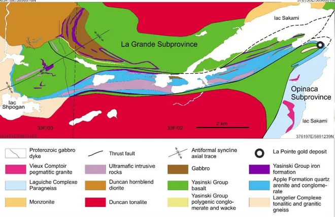
Figure 1.2. Géologie régionale à la proximité du gîte La Pointe au contact entre les
sousprovinces de La Grande d’Opinaca dans le secteur du lac Sakami ... 14
Figure 1.3. Detailed geological map of the La Pointe gold deposit with location of the
zones 25 and 26. ... 15
Figure 1.4. Interpreted geology section looking NNW of the La Pointe deposit ... 16
Figure 1.5. Photographs of structural elements of the La Pointe deposit ... 17
Figure 1.6. Microphotographs and backscattered electron image of Zone 25 mineralization
... 24
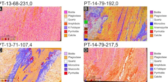
Figure 1.7. µXRF elemental maps of thin section showing the mineralogy and textures. . 25
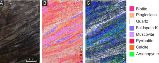
Figure 1.8. Photograph and µXRF elemental maps from a core sample ... 27
Figure 1.9. Microphotographs and backscattered electron image of Zone 26 mineralization
... 29
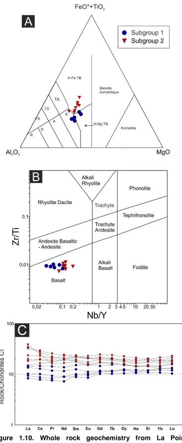
Figure 1.10. Whole rock geochemistry from La Pointe amphibolites ... 31
Figure 1.11. Whole rock geochemistry from Zone 25 paragneiss ... 32
Figure 1.12. Whole rock geochemistry from La Pointe deposit felsic intrusive rocks ... 34
Figure 1.13. Isocon diagrams showing different alterations from Zone 25 ... 36
Figure 1.14. Mineral chemistry of biotite from Zone 25 paragneiss and intrusive rocks .... 38
Figure 1.15. Mineral chemistry of arsenopyrite from the mineralization of zones 25 and 26
... 39
Figure 1.16. Log ƒ(S
2) versus temperature diagram showing stability fields of arsenopyrite
... 40
Figure 1.17. Details of LA-ICP-MS line scan analysis showing element zonations in
arsenopyrite and löllingite ... 42
Figure 1.18. LA-ICP-MS elemental maps of an arsenopyrite-löllingite composite grain from
16-JF-5256A2 sample. ... 43
Figure 1.19. U-Pb geochronology on zircons using LA-ICP-MS method from a sample of a
tonalite and a felsic dyke. ... 48
Liste des tableaux
Table 1.1. U-Pb geochronology on zircons from a tonalite from the La Pointe deposit ... 45
Table 1.2. U-Pb geochronology on zircons from a sheared felsic dyke from the La Pointe
deposit ... 46
vii
Liste des abréviations
MERN : Ministère de l’Énergie et des Ressources naturelles
µXRF : Micro spectrométrie par fluorescence des rayons X
LA-ICP-MS : Spectrométrie de masse à plasma à couplage inductif
INAA : Analyse par activation neutronique
ICP-OES : Spectrométrie par torche à plasma
PGNAA : Analyse par activation neutronique aux gamma prompts
EDS : Analyse dispersive en énergie
BSE : Imagerie en électrons rétrodiffusés
Mg# : Nombre magnésien
SNRC :
Système national de référence cartographique
UTM : Projection transverse universelle de Mercator
NAD83 : Système de référence géodésique nord-américain de 1983
µm : Micromètre (10
-6m)
a.p.f.u. : Atome par unité de formule
ppm : Partie par million
ppb : Partie par milliard
Ab : Albite
Adr : Andradite
Alm : Almandin
An : Anorthite
Apy : Arsénopyrite
AuSb
2: Aurostibite
Bt : Biotite
Chl : Chorite
Cpy : Chalcopyrite
Cpx : Clinopyroxène
Grs : Grossulaire
Grt : Grenat
Gru : Grunérite
Hbl : Hornblende
Kfs : Feldspath potassique
Lo : Löllingite
Mc : Microcline
Ms : Muscovite
Or : Orthose
Pl : Plagioclase
Po : Pyrrhotite
Prp : Pyrope
Qtz : Quartz
Sps : Spessartine
Ttn : Titanite
Tur : Tourmaline
viii
Avant-propos
La réalisation de ce projet de maîtrise a bénéficié du support ainsi que de la collaboration
de plusieurs personnes. Je voudrais tout d’abord remercier François Huot qui a entrepris ce
projet de recherche et qui fut mon premier directeur de recherche. Je remercie grandement
Georges Beaudoin, mon directeur de maîtrise, pour ses conseils, son support et ses
critiques constructives. J’aimerais remercier mon codirecteur, Carl Guilmette, pour ses
discussions constructives qui ont contribué au développement du projet. Merci à Roman
Hanes et Nathan Cleven pour leur encouragement et leur aide. Je remercie Jean Goutier,
superviseur externe et géologue émérite du ministère de l’Énergie et des Ressources
naturelles (MERN), d’avoir également rendu possible ce projet, pour son partage de
connaissances de la géologie de la région d’Eeyou Istchee Baie-James ainsi que ses
conseils. Je voudrais également remercier Don Davis, du Jack Satterly Geochronology Lab
at the University of Toronto, pour avoir réalisé les datations isotopiques; Marc Choquette,
responsable de la microsonde à l’Université Laval; ainsi que Dany Savard et Audrey Lavoie
de l’UQAC du LabMaTer pour leur aide lors des analyses de LA-ICP-MS.
Ce projet a été entièrement financé par le MERN, qui a offert son support logistique et
financier pour la réalisation des travaux sur le terrain, des procédures analytiques, ainsi
qu’une bourse d’études pour l’ensemble de mon parcours. Métaux Précieux du Québec est
également remercié pour avoir donné pour leur support logistique et leur accord pour l’accès
à la propriété.
Ce mémoire de maîtrise contient un manuscrit destiné à une publication dans la revue
scientifique Canadian Journal of Earth Sciences. Le chapitre 1 contenant ce manuscrit est
rédigé selon le style et la langue appropriés en vigueur pour cette revue. Les coauteurs sont
Georges Beaudoin, agissant comme directeur de recherche de ce projet, Carl Guilmette,
codirecteur de recherche, Jean Goutier, cosuperviseur externe et géologue émérite au
MERN, ainsi que Don Davis de l’University of Toronto, responsable des datations
isotopiques U-Pb sur zircons. L’auteur de ce mémoire est l’auteur original du manuscrit tel
que présenté, à l’exception des sections portant sur la géochronologie U-Pb sur zircons
(méthodologie et résultats) qui ont été rédigées par Don Davis. Ce projet a également
contribué à la publication de deux rapports soumis au MERN, le premier publié en 2018 et
le second en 2019.
1
Introduction
La Province du Supérieur est l’hôte de nombreux gisements d’or orogénique en association
avec des structures crustales majeures caractérisées par une histoire tectonique complexe
(McCuaig and Kerrich 1998; Groves et al. 2003; Goldfarb et al. 2005; Robert et al. 2005).
Les zones de faille Cadillac-Larder Lake et Porcupine-Destor, dans la région de l’Abitibi, ont
longtemps été reconnues comme les principales zones pour l’exploration et l’exploitation
minières. Les zones de failles de Larder Lake-Cadillac et de Porcupine-Destor, dans la
région de l’Abitibi, ont longtemps été reconnues comme les principales zones pour
l’exploration et l’exploitation minières. La découverte du gisement Roberto par Mines d’or
Virginia (Robertson 2005; Fontaine et al. 2017), spatialement associée à une discontinuité
régionale qui juxtapose la province volcano-plutonique de La Grande et la
Sous-province métasédimentaire et plutonique d’Opinaca (Card et Ciesielski 1986), a provoqué
une nouvelle vague d’exploration dans la municipalité d’Eeyou Istchee Baie-James. Ces
travaux d’exploration ont permis de mettre au jour de nombreuses minéralisations aurifères
en association avec les ceintures de roches vertes de la région, longtemps considérées
comme étant moins prospectives dû aux styles de minéralisation et au faciès
métamorphique régional plus élevé (Gauthier et al. 2007). Les travaux d’exploration le long
de cette discontinuité ont mené à la découverte et à l’étude détaillée de nouveaux gisements
aux typologies variées, incluant : 1) des veines d’or orogénique déformées localisées surtout
dans la partie nord-ouest du contact (Hanes et al. 2016); 2) de la minéralisation disséminée
associée à une zone de cisaillement comme celle de la zone Marco (Aucoin et al. 2012) ; 3)
des minéralisations disséminées associées à un stockwerk et des zones de remplacement
formées d’altérations potassiques et calco-silicatées comme celles du gîte Roberto
(Ravenelle 2013; Fontaine et al. 2015, 2017) ;
4) de l’or dans des formations de fer rubanées
remplacées par des sulfures accompagnées de veines calco-silicatées et des veines à
quartz-tourmaline comme celles du gîte Orfée (Bogatu 2017) ; ainsi
que 5) d’une
minéralisation précoce en Au-Cu consistant de sulfures disséminés, de veinules de sulfures
et de stockwork, affectée par des zones de cisaillement tardives associées avec des veines
aurifères orogéniques à quartz-tourmaline (Mercier-Langevin et al. 2012). La proximité de
nombreuses minéralisations aurifères avec la discontinuité entre le La Grande et l’Opinaca
suggère que cette structure est un métallotecte favorable au transport et à la concentration
des fluides permettant la formation de gisement d’or orogénique (Gauthier et al. 2007;
Bandyayera et al. 2010; Gigon and Goutier 2017). Ce projet de maîtrise en métallogénie est
2
une partie intégrante d’un groupe de recherche visant à mieux comprendre le contexte
tectono-métamorphique dans les sous-provinces de La Grande et d’Opinaca, ainsi que de
mieux définir ses implications métallogéniques pour la formation de minéralisations
aurifères.
Contexte
Le gîte aurifère La Pointe est situé sur la rive ouest du lac Sakami à ~80 km au sud-sud-est
de Radisson dans le craton archéen du Supérieur, à proximité de la discontinuité régionale
qui juxtapose les sous-provinces de La Grande et d’Opinaca, dans le territoire municipal
d’Eeyou Istchee Baie-James (Figs. 1.1 et 1.2). La zone 26 (connue au début comme l’indice
Lamarche-Lavallée) a été découverte en 1995 par Ressources Dynacor et confirmée par un
échantillon de Géologie Québec (Doucet, 1995; Goutier et al. 2000). Par la suite les
compagnies Matamec et Métaux stratégiques du Canada, maintenant connues sous le nom
de Métaux Précieux du Québec, ont réalisé des travaux en 1998 qui ont permis trouver la
Zone 25. Elle est suivie de la mise au jour d’indices aurifères comme 9.6, JR, EX-43 Simon
et Île. Bien que plusieurs sites minéralisés semblent d’extension limitée, deux zones
aurifères du gîte La Pointe ont fait l’objet de campagnes d’exploration plus extensives. Elles
sont définies comme les zones 25 et 26. Selon les travaux précédents (Lavallée 2014,
2016), la Zone 25 serait située dans la Sous-province d’Opinaca, alors que la Zone 26 ferait
partie de la Sous-province de La Grande (Fig. 1.3). La Zone 25 est définie comme un niveau
aurifère stratoïde contenu dans des roches métasédimentaires et des paragneiss du
Complexe de Laguiche, alors que la Zone 26 est contenue dans un niveau de formation de
fer apparemment non altérée du Groupe de Yasinski. Le gîte La Pointe est encaissé dans
des roches métamorphisées au faciès des amphibolites et est intensément déformé. La
minéralisation des zones 25 et 26 présente des caractéristiques communes au gisement de
type or orogénique hypozonal (Gebre-Mariam et al. 1995), soit par son style de
minéralisation disséminée et en remplacement, et son assemblage d’altération typique des
gisements de plus haute température (Mikucki et Ridley 1993; Ridley et al. 1998; Phillips et
Powell 2009; Kolb et al. 2015).
Objectifs
La proximité du gîte La Pointe à la discontinuité régionale qui juxtapose les sous-provinces
de La Grande et d’Opinaca, son style de minéralisation et le faciès métamorphique élevé
des roches encaissantes en font un cas d’étude significatif pour la compréhension des
3
processus métallogéniques dans le cadre géologique régional de la région d’Eeyou Istchee
Baie James. Cette étude documente un cas de gisement d’or orogénique de type disséminé
dans un environnement de métamorphisme élevé. Les objectifs de cette étude sont les
suivants :
Caractériser les assemblages minéralogiques et métalliques des roches fraîches,
altérées et minéralisées;
Déterminer la nature, l’intensité et la chronologie des altérations associées aux
minéralisations aurifères et leurs relations spatio-temporelles par rapport à la
géologie locale;
Déterminer les affinités géochimiques des différentes lithologies et les corréler avec
les unités géologiques régionales ;
Contraindre la chronologie absolue des évènements géologiques pertinents à la
minéralisation;
Proposer un modèle pour la mise en place de l’or pour le gîte La Pointe, tout en
considérant les aspects tectono-métamorphique de cette partie ouest du contact.
La description détaillée de décapages mécaniques et de forages du gîte La Pointe a été
réalisée afin d’établir le lien entre la minéralisation, les roches encaissantes, la déformation,
ainsi que l’altération hydrothermale. La description minéralogique des zones minéralisées,
l’établissement d’une séquence paragénétique et la caractérisation des altérations ont
permis de définir la typologie de la minéralisation, ainsi que d’établir un lien temporel par
rapport à l’évènement minéralisateur à l’origine de la formation du gisement. Les données
sont complémentées par des analyses à la microsonde électronique et de spectroscopie de
masse couplée à l’ablation laser pour une meilleure caractérisation des assemblages
d’altération, ainsi que l’interprétation de certains processus ayant contribué à la
minéralisation. La comparaison du gîte de La Pointe avec les autres gisements associés au
contact des sous-provinces de La Grande et d’Opinaca contribuera à l’amélioration de la
perspective régionale sur les minéralisations aurifères dans la région d’Eeyou Istchee
Baie-James, ainsi que dans les autres gisements de type or orogénique hypozonal ailleurs dans
le monde.
4
Géologie régionale
Les roches encaissantes du gîte d’or de La Pointe sont situées dans la portion centrale de
la Province géologique du Supérieur (Fig. 1.1), qui comprend, du nord au sud, la
Sous-province plutonique de Minto, la Sous-Sous-province volcano-plutonique de La Grande, les
sous-provinces métasédimentaires d’Opinaca et de Nemiscau, et la Sous-province
volcano-plutonique d’Opatica (Card and Ciesielski 1986; Percival et al. 2012). Les unités
géologiques immédiates du gîte La Pointe appartiennent à deux ensembles archéens
distincts, soit les sous-provinces de La Grande et d’Opinaca telles que décrites par Paquette
et Gauthier (1997) et Goutier et al. (2000, 2001 et 2002).
La Sous-province de La Grande (Fig. 1.1) est un assemblage volcano-plutonique (Card and
Ciesielski 1986; Percival et al. 2012). Elle se compose de gneiss tonalitiques et de tonalites,
paléo à néoarchéenns, constituant un socle à plusieurs endroits, de séquences
volcano-sédimentaires méso à néoarchéennes, de séquences clastiques arénitiques et de
conglomérats, ainsi que de roches intrusives ultramafiques à felsiques. Dans le secteur des
lacs Shpogan et Sakami (Fig. 1.2), les roches les plus anciennes appartiennent au
Complexe de Langelier composé de gneiss tonalitique et granitique et de tonalite à biotite
(Goutier et al., 2000 et 2001). Ces roches ont été datées à 3452 ± 16 Ma et 3326 ± 4 Ma
(Davis et al. 2014; cette étude). Une séquence d’arénite quartzitique et de conglomérat
monogénique à pyrite et uranium de la Formation d’Apple repose en discordance sur ce
socle (Fig. 1.2). Cette séquence sédimentaire est surmontée en concordance, et localement
en contact de faille, par les roches volcano-sédimentaires du Groupe de Yasinski (2751 à
2725 Ma, Goutier et al., 2002). Ce groupe est principalement composé de basaltes
tholéiitiques, de formations de fer au faciès des oxydes et des silicates, de roches
sédimentaires clastiques et de roches pyroclastiques intermédiaires à felsiques. Les
métabasaltes, aux faciès massifs et localement coussinés, forment la lithologie dominante.
Une partie des structures primaires est oblitérée par la déformation à proximité du contact
des sous-provinces de La Grande et d’Opinaca (Goutier et al., 2000). Richer-Laflèche et al.
(2000) et Sappin et al. (2018) suggèrent que l’emplacement des séquences volcaniques est
associé un système de rift continental formé dans le socle tonalitique du Complexe de
Langelier. L’ensemble de ces lithologies est injecté par une tonalite, des diorites et une
monzonite des Intrusions de Duncan (2716 à 2709 Ma) et par des intrusions mafiques et
ultramafiques. Le métamorphisme régional de la Sous-province de La Grande est
principalement au faciès des amphibolites. Il passe du faciès des schistes verts dans la
5
région du lac Yasinski à celui des amphibolites en allant vers les sous-provinces de Minto
et d'Opinaca (Côté-Roberge et al. 2016, 2018; Gigon and Goutier 2017). Il atteint celui des
granulites vers l'est et l'ESE.
La Sous-province d’Opinaca (Fig. 1.1) correspond à un assemblage de roches
métasédimentaires et plutoniques (Card et Ciesielski 1986; Percival et al. 2012). L'unité
dominante est le Complexe de Laguiche. Il est constitué d'une séquence métasédimentaire,
principalement transformée en paragneiss à biotite avec des degrés divers de migmatisation
et de multiples intrusions centimétriques de composition felsique (Card et Ciesielski 1986;
Goutier et al. 2000, 2001, 2002; Morfin et al. 2013; Côté-Roberge et al. 2016; Côté-Roberge
2018). L'âge de ce complexe est contraint par : 1) l’âge du Pluton de la Frégate (2710,4 ±2,4
Ma, Augland et al. 2016) indiquant un âge minimal des paragneiss; 2) l’âge des intrusions
syntectoniques comme celles datées par David (2018) à 2689 Ma et Morfin et al. (2013) à
2660 Ma; et 3) l'âge des granites tardifs coupant les paragneiss et la déformation dominante
(foliation et plissements), de 2640 à 2613 Ma (Goutier et al. 2000; Bogatu, 2017; David,
2019) et
4) les populations de zircon détritiques contraignant un âge dépositionnel maximal
à 2706 ± 2 Ma (Cleven et al. soumis).
L’ensemble de ces roches fortement métamorphisées
et déformées, en plus d'être affecté par un grand nombre d'intrusions granitiques, forme un
large bassin sédimentaire connu comme le Complexe de Laguiche. Dans l’ensemble, les
roches du Complexe de Laguiche sont marquées par un métamorphisme régional élevé, du
faciès des schistes verts (Goutier et al. 2001; Roberge et al. 2016, 2018;
Côté-Roberge 2018) aux granulites (Sawyer 1998; Morfin et al. 2013; Gigon et Goutier, 2017;
Côté-Roberge 2018). Ce métamorphisme est associé avec une migmatisation des
paragneiss avec des pourcentages variables de mobilisat, formant ainsi des métatextites et
des diatextites (Bandyayera et al. 2010; Morfin et al. 2013; Goutier 2018; Côté-Roberge
2018; Roberge et Goutier, 2019). Deux épisodes majeurs ont été définis par
Côté-Roberge (2019), le premier évènement est associé à un métamorphisme de haute
température et de basse pression vers 2670 Ma attribué à l’extension du bassin et le début
de la migmatisation. Vers 2645 Ma, la fermeture et l’épaississement crustal sont associés à
un second épisode métamorphique de haute température et de moyenne pression. Les
travaux de Morfin et al. (2013) suggèrent qu’il s’agit d’un complexe d’injections, où un grand
volume de leucogranite provenant d’anatexie d’une source crustale plus profonde s’est
injecté au travers de la séquence de roches métasédimentaires et qu’un degré variable de
mobilisat proviendrait de la fusion partielle des roches métasédimentaires.
6
Plusieurs intrusions appartenant à la Suite granitique du Vieux Comptoir (2683 Ma à 2613
Ma, Goutier 2018) sont injectées à la fois dans la séquence métasédimentaire de l’Opinaca
et dans les séquences volcano-plutoniques de La Grande. Ces granites présentent
fréquemment des faciès pegmatitiques. La région est également coupée par plusieurs
générations de dykes de gabbro d’âges néoarchéen et paléoprotérozoïque (Goutier et al.
2000, 2001).
Présentation de l’article
Le premier chapitre de ce mémoire contient le manuscrit de l’article intitulé « The La Pointe
gold deposit, a disseminated orogenic gold deposit at the contact between the La Grande
and Opinaca subprovinces, Eeyou Istchee Baie-James, Québec ». Il sera soumis à la revue
scientifique Canadian Journal of Earth Sciences pour publication. Les coauteurs sont
Georges Beaudoin, Jean Goutier, Carl Guilmette et Don Davis. Georges Beaudoin est le
directeur de recherche de ce projet, Carl Guilmette est le codirecteur, Jean Goutier est
cosuperviseur externe et géologue émérite au MERN, et Don Davis a mené la réalisation
des datations isotopiques U-Pb sur zircons.
L’auteur de ce mémoire a réalisé les
manipulations en laboratoire et est l’auteur original du manuscrit tel que présenté, à
l’exception des sections portant sur la géochronologie U-Pb sur zircons (méthodologie et
résultats) qui ont été rédigées par Don Davis. Outre le rôle mentionné précédemment, les
coauteurs ont participé en contribuant intellectuellement à l’interprétation des résultats et à
la discussion.
L’article fait d’abord un survol des modèles de formation de gisement d’or orogénique dans
les contextes de métamorphisme élevé, suivi d’une présentation de la problématique et des
objectifs de l’étude en lien avec le contact entre les sous-provinces de La Grande et
d’Opinaca. Il décrit ensuite la géologie régionale en abordant les principales formations
géologiques constituant les deux sous-provinces. Cette partie est suivie d’une description
de la géologie locale, des éléments structuraux, ainsi que des lithologies principales
présentes sur la propriété. L’article aborde les différentes méthodes analytiques utilisées
suivies par la présentation des résultats. Les zones 25 et 26 sont d’abord décrites en détail
en termes d’assemblages minéralogiques, de séquences paragénétiques, des altérations
hydrothermales et des textures de l’or. Les résultats analytiques incluent des cartes
élémentaires faites au µXRF, la lithogéochimie des unités encaissantes, les données de la
7
chimie minérale obtenues par microsonde électronique, des analyses d’éléments en traces
par LA-ICP-MS de l’arsénopyrite, et des datations isotopiques U-Pb de roches felsiques.
Finalement, la discussion aborde l’environnement géologique du gîte, le lien temporel de
l’évènement minéralisateur par rapport au pic métamorphique, le contenu en or de
l’arsénopyrite, l’altération hydrothermale et les processus de sulfuration, ainsi qu’une
comparaison avec les autres gîtes d’or associés au contact et d’une perspective régionale.
8
Chapitre 1. The La Pointe gold deposit, a
disseminated orogenic gold deposit at the contact
between the La Grande and Opinaca subprovinces,
Eeyou Istchee Baie-James, Québec
1.1 Résumé
Le gîte aurifère de La Pointe est encaissé dans des roches archéennes au contact entre les
sous-provinces de La Grande et d’Opinaca. L’assemblage lithologique, métamorphisé au
faciès des amphibolites et intensément déformé, comprend des roches
volcano-sédimentaires, métasédimentaires et intrusives (de 3326 ± 4 Ma à 2747 ± 2 Ma). La Zone 25
est encaissée dans des paragneiss et comprend de l’or disséminé associé avec des sulfures
et des zones d’altérations. La zone minéralisée est orientée ONO-ESE (S
1) et est déformée
par la schistosité régionale principale (S
2). La Zone 26 est encaissée dans une charnière de
pli d’une formation de fer. C’est une minéralisation de type remplacement. L’or natif est en
inclusions dans les minéraux métamorphiques ou bien dans l’assemblage recuit montrant
que la minéralisation est d’origine pré-métamorphique. Le gîte La Pointe est interprété
comme un gîte d’or orogénique disséminé ayant été affecté par un métamorphisme régional
au faciès des amphibolites.
9
1.2 Abstract
The La Pointe gold deposit is hosted in Archean rocks metamorphosed to amphibolite facies
straddling the boundary between the La Grande and Opinaca subprovinces, in Eeyou
Istchee Baie-James, Québec. The lithological assemblage comprises a tonalite of the
Langelier Complex (3326 ± 4 Ma), quartz arenite from the Apple Formation, amphibolite and
iron formation from the Yasinski Group, and paragneiss from the Laguiche Complex. These
rocks are cut by felsic dykes (2747 ± 2 Ma/2660 ± 9 Ma), ultramafic sills and pegmatitic
granite dykes. The La Pointe deposit is defined in two zones, Zone 25 and Zone 26. Zone
25 is hosted in biotite-rich paragneiss and the mineralization consists of disseminated native
gold along with arsenopyrite, pyrrhotite, chalcopyrite and minor pyrite. The deposit is
oriented WNW-ESE (S
1) and has been deformed and folded by the main regional
deformation (S
2). The mineralization is associated with recrystallized alterations consisting
of quartz, phlogopite, dravite ± titanite, microcline, muscovite and calco-silicates veins.
Native gold occurs as inclusions in the annealed metamorphic assemblages and at the
margin of arsenopyrite. The low content of gold in arsenopyrite suggests re-equilibration at
peak condition during arsenopyrite recrystallization which promotes gold exsolution. Zone
26 is hosted in an iron formation characterized by replacement by sulfides, consisting of
pyrrhotite-arsenopyrite-löllingite-chalcopyrite. The replacement is accompanied by calcic
amphibole-biotite-garnet-tourmaline ± chlorite. Native gold occurs as inclusions in peak
metamorphic minerals, or at the interface between löllingite core and arsenopyrite. The La
Pointe deposit is interpreted as a disseminated, pre-peak metamorphism orogenic gold
deposit, subsequently overprinted by later higher, amphibolite-grade, and late retrograde
metamorphism. This study provide new hints on understanding hypozonal lode gold
deposits with regard to the timing of mineralization in relation to their complex
tectonometamorphic history.
Keywords: Archean
– Orogenic gold – Disseminated – La Grande – Opinaca – Amphibolite
10
1.3 Introduction
Orogenic lode gold deposits are typically distributed in metamorphic terranes in association
with major crustal structures characterized by complex histories of deformation and marking
the boundary between different lithotectonic domains (McCuaig and Kerrich 1998; Colvine
1989; Hagemann and Cassidy 2000,Groves et al. 2003; Goldfarb et al. 2005; Robert et al.
2005). These major structures have been recognized as the main fluid flow pathways to
produce the hydrothermal system allowing the formation of gold mineralization (McCuaig
and Kerrich 1998; Groves et al. 2003; Goldfarb et al. 2005). A vast majority of gold deposits
formed in rocks metamorphosed from greenschist through lower amphibolite facies (Groves
et al. 2003; Goldfarb et al. 2005), although some deposits are hosted in higher-grade
metamorphic rocks (Neumayr et al. 1993; Muir 2002; Kolb et al. 2005; Otto et al. 2007;
Tomkins and Grundy 2009). The timing of mineralization relative to metamorphism is often
constrained from syn- to post- metamorphic peak. However, for deposits in higher
metamorphic grade rocks, relative timing has been a subject of debate. (Moritz 2000; Groves
et al. 2003)
The continuum model (Colvine 1989; Groves 1993) is widely accepted for the formation of
gold deposits in metamorphic terranes. This model proposes that orogenic gold deposits
formed across a widespread range of PT conditions, through an extensive hydrothermal
system from the prehnite-pumpelleyite to the granulite facies. It suggests that gold was
introduced syn- to post- metamorphic peak through the upward migration of gold-bearing
fluids from deep-seated sources along major crustal structures. The formation of hypozonal
gold deposits, particularly those in amphibolite to granulite facies, has been reviewed by
Phillips and Powell (2009, 2010), whom argued that they represent mesozonal deposits
overprinted by later higher-grade metamorphism. Phillips and Powell (2009) argued that the
continuum is unlikely, as extensive hydrothermal systems in those PT condition do not take
partial melting into account. Anatectic melts are typically volatile undersaturated and their
presence would thus prevent the circulation of a free fluid phase. Kolb et al. (2015) reviewed
evidence for syn- to post- peak metamorphism in several hypozonal gold deposits. The
study emphasizes the importance for the timing of mineralization along with complex PT
history concurrently with tectonometamorphic and magmatic evolution of the host terrane.
Kolb et al. (2015) suggested that high metamorphic facies gold deposits formed in evolved
accretionary or collisional orogens, where nappe thrusting with different metamorphic
history, or extensional unroofing, generated inverted PT gradients allowing gold-rich fluid to
11
migrate thought syn- to post- peak shear zone in high grade metamorphic rocks. The
relationship between timing of mineralization and metamorphism remains equivocal, and
thus more studies of orogenic gold deposits in high grade terranes are required to improve
exploration model in these geological setting.
In Eeyou Istchee Baie-James area, Québec (Canada) gold occurrences in the La Grande
Subprovince in the Superior Province have been known for eighty years. However, owing to
their higher metamorphic grade and disseminated style of mineralization, the narrow
amphibolite facies greenstone belts were considered unfavorable to prospect for gold
deposits (Gauthier et al. 2007). Since the discovery and definition of the Roberto deposit
[Éléonore gold mine] (Robertson 2005; Fontaine et al. 2017), the La Grande and Opinaca
subprovinces boundary has been recognized as a favorable metallotect for exploration for
orogenic gold. Gold deposits along this boundary (Fig. 1.1) include the Roberto deposit
(Ravenelle et al. 2010; Ravenelle 2013; Fontaine et al. 2015, 2017), Orfée (Bogatu 2017),
Marco zone (Aucoin et al. 2012) and zone 32 (Mercier-Langevin et al. 2012) in addition to a
number of smaller gold occurrences. Among those, the La Pointe deposit is defined in two
zones, Zone 25 and Zone 26, which shares common characteristics with other amphibolite
facies deposits, such as its disseminated and replacement style, and its alteration
assemblage typical of higher-grade deposits (Mikucki and Ridley 1993; Ridley et al. 1998;
Phillips and Powell 2009; Kolb et al. 2015). Because of its proximity to a major regional
discontinuity along with other recently studied deposits, the amphibolite grade rocks, and its
mineralization style, the La Pointe deposit provides an interesting opportunity for studying
the timing of mineralization and metallogenic processes in deposits hosted in high-grade
terranes.
This study documents the geology along with textural and mineralogical characteristics, the
paragenetic sequence, the geochemistry of host rocks and hydrothermal alteration, the
mineral chemistry and geochronology of the La Pointe deposit in order to constrained the
condition of the gold mineralization events. Better constraining the typology of the deposit
and the relationships between auriferous mineralization and metamorphism will contribute
to a better understanding of “hypozonal” orogenic gold deposits, and provide regional
perspective for gold exploration in amphibolite facies Archean greenstone belts.
12
1.4 Regional geology
The La Pointe deposit is hosted in Archean rocks of the eastern central part of the Superior
Province (Fig. 1.1), in Eeyou Istechee Baie-James region. The lithological units are part of
two Archean lithotectonic assemblages, the La Grande volcano-plutonic Subprovince, and
the Opinaca metasedimentary and plutonic Subprovince (Card and Ciesielski 1986). The
contact between these subprovinces is either locally concordant, or corresponds to highly
deformed areas with shear zones inclined towards the north or north-west, locally intruded
by late, undeformed to sheared intrusions (Goutier et al. 2000, 2001, 2002; Bandyayera et
al. 2010; Gigon and Goutier 2017). The La Grande Subprovince (Fig. 1.1), in the north and
western part, is composed of an ancient tonalitic basement, meso to Neoarchean
volcano-Figure 1.1. Regional geology of Eeyou Istchee James-Bay region, Quebec. Modified from Houlé et al. (2015). 1) Marco zone, 2) Orfée deposit, 3) zone 32 deposit, 4) Roberto deposit (Éléonore gold mine) and 5) La Pointe deposit.
13
sedimentary sequences and felsic to ultramafic intrusive rocks (Paquette and Gauthier,
1997; Goutier et al. 1999, 2000, 2001). It is bounded to the north by the Minto, to the south
by the Nemiscau and the Opinaca, and to the east by the Ashuanipi subprovinces (Fig. 1.1).
In the immediate area of the deposit (Fig. 1.2), the La Grande Subprovince is composed of
the Paleoarchean Langelier Complex (3452 ± 16 Ma and 3326 ± Ma; Davis et al. 2014; this
study), which is comprised of tonalitic to granitic gneiss and biotite tonalite (Goutier et al.
1999, 2000). The basement rocks are unconformably overlain by a sequence of quartz
arenite and monomictic quartz pebble conglomerate of the Apple Formation. The overlying
volcano-sedimentary rocks of Yasinski Group (2751 to 2725 Ma; Goutier et al. 1999, 2000)
mainly consist of mafic volcanic rocks, iron formation, clastic sedimentary rocks and
intermediate to felsic pyroclastic rocks. Richer-Laflèche et al. (2000) and Sappin et al. (2018)
suggested that the Yasinski Group volcanic rocks were emplaced in an ensialic continental
rift associated with a mantle plume during Neoarchean extension
.
Tonalitic,dioritic and
monzonitic rocks of the Duncan Intrusions (2716 to 2709 Ma), together with ultramafic
intrusions, intrude the basement and supracrustal sequences of the La Grande Subprovince
(Goutier et al. 1999, 2000). The metamorphic grade in the region varies from amphibolite
facies in the Minto Subprovince to greenschist facies toward the Opinaca Subprovince, and
to granulite facies in the eastern part in the Ashuanipi Subprovince (Côté-Roberge et al.
2016, 2018; Gigon and Goutier 2017).
The Laguiche Complex forms much of the Opinaca Subprovince (Figs. 1.1 and 1.2), it
corresponds to a sedimentary basin with a complex tectonometamorphic history
(Bandyayera et al. 2010; Morfin et al. 2013; Gigon and Goutier 2017; Goutier 2018;
Côté-Roberge 2018; Côté-Côté-Roberge et Goutier, 2019). The depositional age is constrained
between 2710 Ma (Augland et al. 2016) and 2706 Ma (Cleven et al. submitted). The
Laguiche Complex is mainly composed of wacke metamorphosed to a biotite ± garnet ±
hornblende ± orthopyroxene paragneiss with variable degrees of migmatization. It contains
a significant proportion of leucogranite in the form of veins, dykes and sills, forming an
injection complex (Morfin et al. 2013, 2014). The migmatization of the rocks is associated
with metamorphic grade increasing abruptly from greenschist to granulite, from the north to
the south, and from the west to the east (Côté-Roberge 2018 and references therein). Two
episode of regional metamorphism are documented. A first, high-temperature low-pressure
metamorphic event around 2670 Ma is associated with crustal extension and the onset of
migmatization. A second medium-pressure high temperature metamorphic event at ca. 2645
14
Ma is associated to basin closure and crustal thickening (Côté-Roberge 2018), an evolution
similar to that recently proposed for the Pontiac Subprovince bounding the Abitibi
Subprovince to the south (Piette-Lauzière et al. 2019).
Figure 1.2. Regional geology of the La Pointe gold deposit, at the boundary between the La Grande (west) and the Opinaca (east) subprovinces in the Shpogan and Sakami lakes area (33F02 and 33F03). Modified from Goutier et al. (2000) and Goutier and Gigon (2016). Coordinates are in UTM NAD83, zone 18
1.5 Deposit geology
The La Pointe deposit geology shows a regional stratigraphic sequence with an apparent
thickness of ~200 meters (Fig. 1.3). Mineralization is defined in two zones, Zone 25 and
Zone 26, separated by about 50 m vertically, (Fig. 1.4). The main lithological units form an
inverted sequence, from WNW to ESE, comprising, from structural top to base, a sliver of
tonalitic rocks of the Langelier Complex, quartz arenite of the Apple Formation, amphibolite
and iron formations of the Yasinski Group, biotite-rich paragneiss of the Laguiche Complex
and minor felsic to ultramafic intrusive rocks (Fig. 1.4).
Regional bedding (S
0) is locally preserved in the quartz arenite and banded iron formation.
All the units are affected by a penetrative regional foliation (S
2) striking SW-NE with a steep
15
main ductile deformation is associated with amphibolite facies metamorphism. The units
form an synformal anticline where the southeastern limb of the fold correspond to a high
strain zone (Fig. 1.5C). The S
1foliation is preserved in the hinge of this fold, where it strikes
approximately WNW-ESE and appears subparallel to S
0(Fig. 1.5B). It is intensely folded by
the main F2 isoclinal folds, forming “M” and “S” parasitic folds to which the penetrative S
2main
foliation is axial planar. The fold axes (37→224) are subparallel to the stretching
lineation (L
2; 34→231) (Figs. 1.3 and 1.5D). These folds and lineations are indicative of a
compressive regime with stretching of rocks in the direction of the fold axis.
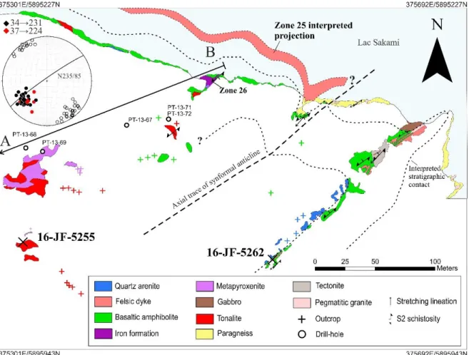
Figure 1.2. Detailed geological map of the La Pointe gold deposit with location of the zones 25 and 26, and the interpreted projection outline of Zone 25. See figure 1.4 for the interpreted geology section (A-B). Stereonet showing poles of S2 foliation (empty black circle), stretching lineation (L2; black diamond)
and fold axis (red diamond). The two dated samples are located on the map (16-JF-5255 and 16-JF-5262). Coordinates are in UTM NAD83, zone 18.
16
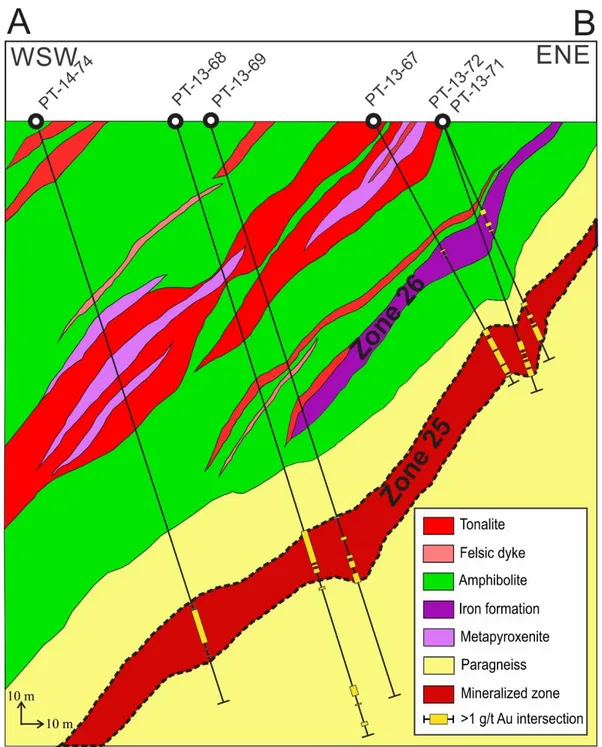
Figure 1.3. Interpreted geology section from field observations and drill hole logs of the La Pointe deposit. Section looking NNW. The section is constructed from PT-14-74, PT-13-68, PT-13-69, PT-13-67, PT-13-71 and PT-13-72 drill holes.
17
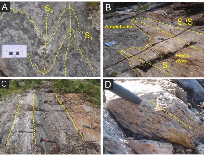
Figure 1.4. Photographs of structural elements. A) Tightly folded amphibolite with axial trace corresponding to the main S2 foliation striking NE-SW (outcrop 16-JF-5282). B) Felsic dyke folded in
strongly deformed amphibolite. The contact defines a composite S0/S1 structure and axial trace are
striking NE-SW along regional foliation (S2) (outcrop 16-JF-5264). The notebook is 23 cm in length. C)
Sheared fold limb of the south-eastern limb of the anticline. From left to right; amphibolite, felsic dyke, amphibolite and pyrite-rich quartz arenite (outcrop 16-JF-5262). The hammer is 40 cm in length. D) Stretching lineation (L2) defines by micas in the tonalite forming an L>S tectonite (outcrop 16-JF-5255).
1.5.1 Supracrustal rocks
1.5.1.1 Quartz arenite
The quartz arenite of the Apple Formation outcrop mostly in the sheared fold limb (Figs. 1.3
and 1.5C). The unit consists of a fine to coarse-grained rocks mostly compose of quartz (up
to 95 %), with 3 % of muscovite, 2 % of plagioclase and, locally, with trace of fuchsite. The
rock contains locally up to 15 % of pyrite stretched along the main S
2foliation.
1.5.1.2 Amphibolites
Amphibolites of the Yasinski Group characterize a major unit that is in normal contact with
the quartz arenite (Figs. 1.3 and 1.4). The amphibolites is medium grained and dark green
18
in color. It contains 60 to 80 % of hornblende, plagioclase, and minor biotite, cummingtonite,
chlorite, epidote, quartz, apatite, carbonate, and ilmenite and/or titanite. Sulfides consist
mostly of pyrrhotite and chalcopyrite, with trace amounts of arsenopyrite, pyrite and
exsolutions of pentlandite flames in pyrrhotite. The rock has a coarse texture due to
metamorphic recrystallization. The rock is strongly foliated and stretched in the southeastern
limb, toward the fold hinge and near the contact with the paragneiss (Fig. 1.5C). The foliation
is defined by subhedral hornblende and alignment of lenticular clusters of granoblastic
plagioclase and ilmenite. The rock is locally altered with pervasive biotite, garnet
porphyroblasts, calc-silicate alteration with plagioclase-amphibole veins, intergranular
microcline and quartz-pyroxene veins. No significant gold contents is associated with this
unit.
1.5.1.3 Iron formation
The iron formation hosts Zone 26 mineralization. It forms a metric, discontinuous, layer in
the amphibolite, which crops out on the shore of lac Sakami (Figs. 1.3 and 1.4). The iron
formation comprises oxide and silicate facies, and contains zones of sulfide replacement
associated with gold mineralization. The unit defines a synform with a thickened hinge and
is thinned considerably toward the fold limbs. The S
0/S
1banding is preserved in the fold limb
and disrupted in the fold hinge. The banding varies in thickness from 0.5 to 5 cm. When
unmineralized, the rock is composed of alternating banding of 25 % quartz, 40 %
quartz-grunerite and 35 % quartz-grunerite-magnetite and trace of ferroactinolite. It can contains
accessory apatite, chlorite and carbonate, and trace amount of sulfides such as pyrrhotite ±
arsenopyrite. Grunerite is euhedral to subheudral and is randomly oriented, suggesting
post-deformation growth.
1.5.1.4 Paragneiss
Paragneiss hosts Zone 25 mineralization and is structurally overlain by the amphibolite
(Figs. 1.3 and 1.4). The rock is fine- to medium grained, foliated, and is characterized by a
granoblastic and lepidoblastic textures. The unit consists of a recrystallized matrix of 40-60
% of plagioclase, 10-30 % of quartz, and locally up to 5-8 % of K-feldspar and subhedral
actinolite. It contain 20-35 % of biotite, which forms a well-developed foliation (S
2), with
accessory titanite, apatite, clinozoisite, calcite and tourmaline, and trace pyrrhotite, pyrite,
minor chalcopyrite and, locally, arsenopyrite. . It locally contains up to 5 % of felsic veins
interpreted as leucosome segregations, composed of feldspar-quartz-biotite, which are
subparallel to S
2.
19
1.5.2 Intrusive rocks
1.5.2.1 Tonalite
The rock is tonalitic to granodioritic in composition, fine- to medium-grained, showing a
strong lineation (L
2) and foliation (S
2) defined by micas (Fig. 1.5D). The rock is composed of
35 % of granoblastic plagioclase and 5 % seriticized plagioclase porphyroblast, 25 % coarse
quartz, locally up to 10 % of K-feldspar in bands, 15 % preferentially aligned biotite and 8 %
muscovite in ribbon. Accessory minerals are apatite, ilmenite, clinozoisite and sericite. The
rock contains traces of pyrrhotite, chalcopyrite and pyrite that is locally replaced by
pyrrhotite.
1.5.2.2 Felsic dykes
Felsic dykes crosscut the amphibolite in the eastern part of the deposit (Fig. 1.3). It is tightly
folded (F
2) in the hinge zone (Fig. 1.5B), where the contact represents a composite S
0/S
1surface indicating dyke emplacement prior or syn- S
1, or is highly foliated and transposed in
the S
2fabric (Fig. 1.5C) in the sheared fold limb. The rock is fine to very fine grained and
shows microporphyric texture defined by quartz porphyroclast. The granoblastic matrix is
composed of 60 % quartz, 20 % plagioclase, and 12 % preferentially oriented biotite and 8
% muscovite defining a lepidoblastic texture.
1.5.2.3 Metapyroxenite
Sills of metapyroxenite crosscut the tonalite and locally the amphibolite (Fig. 1.4). The
pyroxenite is medium grained, massive to weakly foliated, and medium to dark green in
color. The unit is mostly composed of random to weakly foliated euhedral to subhedral
tremolite±actinolite locally showing a radial structure, interstitial chlorite, minor disseminated
phlogopite and magnetite. Pyrite, pyrrhotite, sphalerite and chalcopyrite are in trace
amounts.
1.5.2.4 Pegmatitic granite
Undeformed granitic dykes cut the paragneiss and Zone 25 (Fig. 1.3). The rock is massive
and underformed, coarse grained to pegmatitic, and is composed of
K-feldspar-plagioclase-quartz-tourmaline along with accessory garnet and apatite. The rock contains trace amounts
of idiomorphic arsenopyrite associated with local anomalous gold contents.
20
1.6 Analytical methods
A total of 82 samples were selected from drill cores, trenches and outcrops which are
representative from different host rock lithologies and of the mineralization from zones 25
and 26. All samples for this study are reported in the Appendix 1. Field observations were
completed along with petrographic observations and whole rock geochemistry to establish
the links between mineralization, the host rocks, deformation and hydrothermal alteration.
Detailed petrographic observations were complemented with µXRF elemental maps to
characterize the mineralogical assemblage of alterations and the ore mineralogy, to
establish a paragenetic sequence and to constrain the condition of the gold mineralization
events concurrently to the metamorphic events. The whole-rock geochemistry helped
understanding the magmatic affinity of intrusive rocks, differentiated subunits among
lithologies and defined the chemical changes owing to alteration and mineralization.
Relevant samples were further investigated for mineral chemistry for major and trace
elements by microprobe analysis and La-ICP-MS, to characterized silicates and sulfides
compositions, and to constrained mineralizing process. Lastly, U-Pb geochronology was
carried out for determining the age bracket of the host rocks of La Pointe gold deposit.
1.6.1 Lithogeochemistry
The samples selected include 34 mineralized and least altered paragneiss, 9 iron
formations, 16 amphibolites, 6 felsic intrusions, 6 metapyroxenites and 2 quartz arenites.
Whole rocks analysis were performed at Activation Laboratories Ltd. in Ancaster, Ontario,
Canada. Major and minor elements such as Ag, Ba, Be, Co, Cs, Ga, Ge, Hf, In, Pb, Sn, Ta,
Te, Th, Tl, V, U, W and rare earth elements (REEs) were analyzed ICP-MS method; and As,
Au, Br, Cr, Fe, Ir, Na, Sb and Sc with the INAA method described by Hoffman (1992). Cd,
Cu, Mo, Ni, S and Zn were obtained using ICP-OES and B was analyzed with PGNAA
method. Refer to the laboratory website for the detection limits of different methods
(Activation Laboratories Ltd, 2019).
1.6.2 Electronic Probe Micro-Analysis
The composition of biotite, feldspar, amphibole, tourmaline, pyroxene, garnet, arsenopyrite,
pyrrhotite and löllingite was determined using a five WDS CAMECA SX-100 at Université
Laval. The analytical condition were set at 15 kV and 20 nA electron beam, counting 15 to
21
1.6.3 LA-ICP-MS
LA-ICP-MS analyses were conducted on arsenopyrite and löllingite at the LabMaTer at
Université du Québec à Chicoutimi, Saguenay, Canada, using a Resonetics Resolution
M-50 Excimer 193 nm laser coupled with an Agilent 7700x ICP-MS. Analytical conditions were
set with beam size of 20 to 33 μm, a stage speed of 5 μm/s and a laser frequency of 10 Hz
at a power of 2 mJ/pulse. Quantitative and qualitative results were obtain performing laser
ablation (n = 90) on polished thin section (n = 9) for 15 to 60 s depending on grain size after
measuring the gas blank for 30 s. The analyzed elements and their isotopes are the
chalcophile elements (
33S,
34S,
56Fe,
57Fe,
59Co,
60Ni,
63Cu,
65Cu,
66Zn,
75As,
77Se,
78Se,
82Se,
95Mo,
107Ag,
109Ag,
121Sb,
125Te,
128Te,
130Te,
185Re,
189Os,
197Au,
208Pb and
3S
209Bi), and
28Si
and
29Si to monitor silicate inclusions
.GES-1g (Guillong et al. 2005) was used as the primary
standard for all elements and Fe was used as an internal standard. Other in-house standards
such as JB-MSS-5 and Laflamme were analysed to verify reproduction of results. The data
reduction was conducted using the Iolite software (Woodhead et al. 2007; Woodhead et al.
2008; Paton et al. 2011).
1.6.4 MicroXRF
Elemental mapping was conducted with a Bruker M4 TORNADO µXRF spectrometer at
Université Laval, Québec, Canada. One drill core sample and 42 thin sections and were
selected to map the chemical distribution of Si, Ca, K, Fe, Ti, S, As, Al, P and Mn, in order
to highlight mineral assemblages and textures at the thin section scale. Analytical conditions
were set to a voltage of 50 kV and a current of 300 µA, with a beam size of 20 µm, an
acquisition time of two milliseconds per pixel and a step size of 20 µm.
1.6.5 U-Pb geochronology
Two samples of intrusive rocks were selected for U-Pb radiometric dating to constrain their
ages of crystallization and for determining the age bracket of the host rocks of La Pointe
gold deposit. The first sample is from a tonalite with a strong lineation fabric (16-JF-5255A)
whereas the second is from a foliated microporphyric felsic dyke crosscutting amphibolite
(16-JF-5262D). The analysis were performed on zircons using LA-ICP-MS method at the
Jack Satterly Geochronology Laboratory of University of Toronto, Canada. The samples
were crushed using a jaw crusher followed by a disk mill. Heavy mineral separation was
carried out with a Wilfley table followed by paramagnetic separation with Frantz isodynamic
22
separator and density separations using bromoform and methylene iodide. Least cracked
zircon grains were hand picked under microscope.
The zircons were analysed by LA-ICP-MS using a 213 nm New Wave laser that pulsed at 5
Hz and operated at an energy flux of 5 J/cm
2.
207Pb (70 ms),
232Th (10 ms) and
238U (20 ms)
data were collected.
No corrections were made for common Pb, since the
204Pb peak is
too small to be measured precisely
Analysis was performed on mount and polish grains
by spot analysis. The spots were pre-ablated with larger beam for 1 sec before laser
sampling. The data were collected after a periode of 10 s for baseline before starting data
collection for 25 s followed by 40 s of washout period. About 140 measurement cycles per
sample were produced with ablation pit of 15 µm in diameter. Th/U ratio is used as a
petrogenetic indicator and was also measured. Two zircon standards were used : a quartz
diorite (DD85-17) from Marmion batholith in northwest Ontario previously dated at 3002 ± 2
Ma by ID-TIMS (Tomlinson et al. 2003) and a monzodiorite (DD81-29) from the Pontiac
Subprovince of Québec dated at 2682 ± 1 Ma (Davis 2002). Data were edited and reduced
using custom VBA software (UtilLAZ program). he U-Pb isotopic data are plotted and using
Isoplot program (Ludwig 1998, 2003) in a “concordia” diagram.
1.7 Mineralization
1.7.1 Zone 25
Zone 25 is characterized by finely disseminated sulfides and native gold hosted in foliated
biotite-rich paragneiss (Fig. 1.7A). Gold grades vary from 1 to 14.7 ppm (this study) within a
WNW-ESE and SSW dipping ore body along the S
1foliation, in the hinge zone of the
anticline (F
2), at the contact between the La Grande and Opinaca subprovinces (Fig. 1.3).
The deposit is 800 m long by 550 m wide, and is followed to a depth of 400 m below surface
(Corporation Métaux Précieux du Québec, 2019). The sulfide assemblage consists of
arsenopyrite, pyrrhotite, with minor chalcopyrite (Figs. 1.6A and 1.6B) and pyrite, and traces
of sphalerite and galena, transposed along the main foliation (S
2). Rare poikiloblastic
arsenopyrite grains (Fig. 1.6C) containing inclusions of biotite, plagioclase, rutile, apatite and
zircon, form an early generation of arsenopyrite (Apy1). This early generation is always
rimmed by arsenopyrite overgrowth (Apy2). Apy2 is the most widespread variety, is
fine-grained (<50 µm) and forms euhedral to subhedral porphyroblasts. Gold contents correlate
with arsenic contents in samples. Pyrrhotite is generally coarser grained (Fig. 1.6A) and in
textural equilibrium with Apy2 and the silicate matrix. Native gold is disseminated with grain
sizes ranging between <5 to 40 µm in the paragneiss. It occurs interstitial to silicates or
23
forms inclusions within the metamorphic assemblage, usually in association with
plagioclase, biotite, microcline and clinozoisite, and locally scheelite, or in dravite
(magnesian tourmaline) ± titanite veins (Fig. 1.6B). Gold grains also occur in inclusions in
sulfides, commonly within arsenopyrite and locally in pyrrhotite (Fig. 1.6A), or forms grains
between sulfides
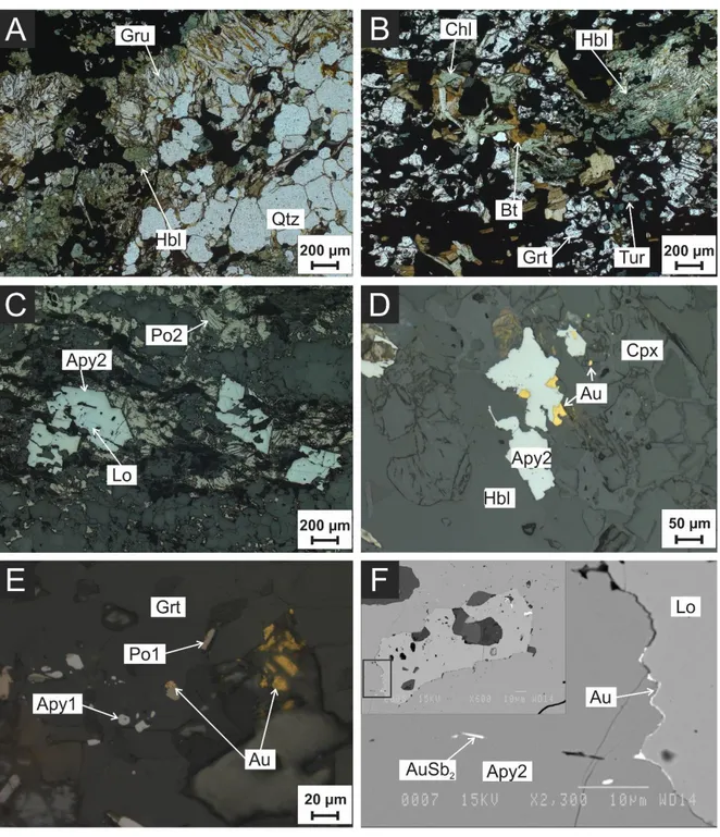
24
Figure 1.5. Microphotographs from Zone 25 mineralization and backscattered electron image. A) Idioblastic arsenopyrite (Apy2) along with pyrrhotite (Po) and chalcopyrite (Cpy). Native gold (Au) is presents as inclusions in dravite. Reflected light from sample PT-15-87-223,0. B) Free native gold in inclusions within the silicate matrix near by subhedral arsenopyrite (Apy2). Reflected light from sample PT-14-79-194,0. C) BSE image from an older poeciloblastic arsenopyrite core (Apy1) rimmed by idioblastic arsenopyrite (Apy2). The crystal does not shows compositional zoning. Sample PT-14-79-194,0. D) Light brown to honey brown euhedral dravite (Tur) cutting biotite (Bt) zone. Cluster of titanite (Ttn) is associated with tourmaline. Transmitted light from sample PT-15-87-223. E) Recrystallized potassic alteration showing granoblastic microcline (Mc) along with minor muscovite. Cross-polarized transmitted light from sample PT-15-87-225,0. F) Idioblastic muscovite (Ms) with granoblastic quartz-feldspar matrix and minor dravite (Tur). Transmitted light from sample PT-13-71-115,3.