HAL Id: sic_00827031
https://archivesic.ccsd.cnrs.fr/sic_00827031
Submitted on 28 May 2013
HAL is a multi-disciplinary open access
archive for the deposit and dissemination of
sci-entific research documents, whether they are
pub-lished or not. The documents may come from
teaching and research institutions in France or
abroad, or from public or private research centers.
L’archive ouverte pluridisciplinaire HAL, est
destinée au dépôt et à la diffusion de documents
scientifiques de niveau recherche, publiés ou non,
émanant des établissements d’enseignement et de
recherche français ou étrangers, des laboratoires
publics ou privés.
POLITICAL ADMINISTRATIONS ON THE
INTERNET: WHAT KIND OF TERRITORIAL
NETWORK REPRESENTATION? AN
EXPLORATION INTO THE FRENCH DISTRICT OF
”PROVENCE ALPES COTE D’AZUR”
Guillaume Perrin, Eric Boutin
To cite this version:
Guillaume Perrin, Eric Boutin. POLITICAL ADMINISTRATIONS ON THE INTERNET: WHAT
KIND OF TERRITORIAL NETWORK REPRESENTATION? AN EXPLORATION INTO THE
FRENCH DISTRICT OF ”PROVENCE ALPES COTE D’AZUR”. IADIS International Conference
2006, Jul 2006, Ireland. pp.1-12. �sic_00827031�
POLITICAL ADMINISTRATIONS ON THE INTERNET:
WHAT KIND OF TERRITORIAL NETWORK
REPRESENTATION?
AN EXPLORATION INTO THE FRENCH DISTRICT OF “PROVENCE ALPES COTE D’AZUR”
Guillaume Perrin
Research associate (Doctorant - ATER) laboratoire I3M - Université du Sud (France)
guillaumeperrin@yahoo.com + 33 4 94 14 23 56
Eric Boutin
Lecturer (Maître de conferences), laboratoire I3M – Université du Sud (France)
boutin@univ-tln.fr + 33 4 94 14 23 56
Laboratoire I3M Université du Sud Toulon - Var BP 20132 FRANCE-83957 La Garde Cedex
ABSTRACT
The administration includes various actors at various degrees, each one with its own structure, level, and mission. This representation is first of all, the result of a historical process which was built progressively through the society evolution, with its coincidences and whose assembly produced a whole of structures which are superimposed and intermingle. Therefore, we will focus on the representation of the mutual relations of the political administrations that are offering on line contents. Through that, we will consider a macroscopic vision of these interrelationships, and in the same move, we will try to represent an embryo of the administration network pattern. We start by considering the point of view that a system can be partly defined by the means of the interconnections that maintain connected the elements which constitute it.
KEYWORDS
Political administration, hypertext, internet, network, link, webometry
1. INTRODUCTION
One of the characteristics of the administrations is its capacity to preserve institutions which were established at a given time, corresponding then, to a situation well defined and to specific circumstances. Even if the historical contribution and the addition of the experience are undeniable, the result does not remain less faded. One of the reasons is due the frictions of the sequences and their succession. In spite of official representations schemes and stricto senso definitions of these administrations such as we know them today, this aggregation generally remains obscure from the point of view of the user, for whom it is not obvious to distinguish all their specific missions.
With that, several explanations can be considered, particularly including one which proves to be relevant, and which is the influence of a territory. Indeed, so far administrative cuttings have all been defined in close connection with the territory, from the necessity to define its physical limits, to the nature and the range of the administration which was going to be established. In an obvious way, it is thus natural to describe the close connection of a territory with its geographical representation.
However, on line and new possibilities of public information broadcast, particularly with the development of Internet, allow today to free itself from these physical bounds and potentially from these psychological barriers.
Consequently, several questions can be asked and investigated:
How the logic of a bureaucratic system, in which each level is organized according to its own reasoning system and makes separation between each one of them, is reflected on the Internet? Will the reticular nature of the internet and the hypertext link which is freed from the hierarchical contingencies and sets of themes, deteriorate this identity logic? Can we consider a model of relations for the public institutions which would be generated by the Web sites and being based on the hypertextual relations?
All these questions can be summed up in one: What kind of territorial network representation for the Political administrations on the internet?
In order to answer it, we will focus, on an experimental basis, on the existing hypertexts interactions between the actors of the public internet, in the District of “Provence Alpes Côte d’Azur” (South of France).
After reporting a state of the art based on former work in this field, we will describe the data processing sequence which we implemented. It consisted, starting from the most complete census of the regional public Web sites, to collect the outgoing hypertexts links emanating from each one of them. The cartographies and indicators of the relational webometry are then deployed in order to highlight the existing interactions between the objects of study and to reconstitute the territorial network established from the regional public Web sites.
It is essential to notice that before considering the nature, context, and environment of the hypertext link (which can be the subject of a new article), we only took into account if there was or not an hypertext link between the observed websites. Then, this allowed us to build and describe several representations using network mapping.
2. STATE OF THE ART
2.1 Context: the concern for the regional public internet
Before going further on in our study, it seems necessary to define in a few words the administrative French divisions.
France is divided into several “regions” that we will call here “administrative district”. Then, those “regions” are divided into “départements”, which will be called for the purpose of our paper “Counties”. The last administrative level concerns the municipalities (cities, town etc.). We will also later on, talk about intercommunal structures which are the result of various municipalities put together.
France counts more than 7000 public Web sites, including the whole of the levels of a territory scale (from national to communal). From now on, the public Internet has been affirmed as a new support of the relation with the users and the citizens, at the sides of the existing channels.
Several years after the first achievements, the overall report remains a system of reasoning using the “supply logic”, while in fact, few projects fit truly in the “demand logic”.
In a growing process of regionalization, the administrative district illustrates the delicate position to make reconcile national and European public information with the one with its inherent to its own region territory. On the basis of this report, many French administrative districts became interested in the census and in the evaluation of the regional public Internet. It is most of the time only a question of carrying out an inventory of the regional public Internet, while allowing interregional comparisons.
We were associated, along with the Cabinet “Proposition”, to a mission which purpose was to study, make a census and evaluate the Paca administrative district public Internet. This study falls under the strategy of a creation and development of an “information society” in the Provence Alpes Côte d’Azur area. It was carried out in partnership between the district government and the State, and supported financially by the European Commission.
2.2 Positioning compared to what exists
A review of the literature enabled us to reach the reports produced within the framework of similar missions ordered by other French districts.
Inter-district reports: the reports eRégions carried out from the end 2002 to the end 2003 (French regions : Limousin, Midi Pyrénées, Pays de la Loire, Poitou Charentes), Sensitic 2004 (sensitic.org, associating the Bretagne, Poitou Charentes, Aquitaine, Rioja/Espagne, Algarve/Portugal, South East Ireland/Irlande, Carmarthenshire/Grande Bretagne), “Statement on the development of the Municipality Public internet, end 2004» (Ile-de-France, Pays de la Loire, Midi Pyrenees)
Districts reports: Municipality public internet 2004 (Ile de France), Information society diagnostic 2004 (Aquitaine).
National reports: Odea 2004 (France), Webmunicipal2004 (Québec), Internet City 2004 (100 biggest French cities)
Thematic report: Touristic internet census (report made by the Midi Pyrénées District over all the touristic sites in the area, end 2003), report ADCF 2004 (intercommunal structures on the internet)
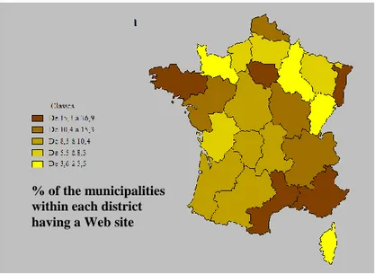
An analysis of existing shows that the former studies are almost always based on indicators resulting from “descriptive statistics”: percentage of municipalities having a Web site, percentage of the population covered by the Web. Figure 1 which expresses the percentage of the municipalities of each districts of France equipped with a Web site, is given to illustrate this type of indicators family.
Figure 1: percentage of the municipalities within each district having a Web site
Figure 1 shows that the Paca district, with 28% of the communes on line, is in a good position in term of % of municipalities having a Web site.
It appears in second position right after the “Ile de France” district in term of the web cover.
Limiting itself to this type of indicators, imply depriving itself of a characteristic of the Web to be an inter-connected network. Then, on what we are going to focus here, is not the fact so much that such municipality or such intercommunal structure has a Web site but rather the way in which these Web sites are inter-connected together.
The regional public Web is a network in which interact various independent territorial actors with separate sets of themes in their own jurisdiction. It is then interesting to reconstitute the territorial network.
% of the municipalities within each district having a Web site
For that, we identified the hypertexts links between these Web sites. The hypertexts links can have different meanings. Thus, we know that links can be created in a negative context or with goal of denigration. In opposition to that, there are other contexts which give them a value much more positive, and which, most of the time, generates a mark of recognition (Egghe, 2000).
Within this study, the context in which the link appears has not been taken into account because we have considered that the main reason of having a hypertext link was legitimization. Indeed, the hypertext link in a non-commercial public sphere has the significance rather near to the recommendation or the legitimization, which was valid at the beginning of the Web and which is now decreasing alongside with the development of the commercial Web.
3. THE DATA PROCESSING SEQUENCE
We built a chain of collection and data processing which consisted, starting from the most complete possible statement of the regional public Web sites, in collecting the outgoing hypertexts links from each one of them. The cartographies and indicators of the relational analysis are then deployed to give an account of the existing interactions between the objects of the study.
3.1 Facts of the case:
The district administrative panorama is composed of various types of actors and these Web sites emanate from various levels:
From the National government services From the district (région)
From the county (département) From the municipalities (communes)
From the intercommunal structures (Intercommunalités)
Our approach consists in gathering the addresses of the Web sites which are the subject of our study in the PACA perimeter. At the time of this stage, approximately 444 Web sites have been identified, establishing thus our corpus.
3.2 Construction of the interactions:
In order to make visible the interactions between the websites from the corpus, we thus used a crawler called Xenu. This tool makes it possible to recover, by exploration, all the outgoing links of a Web site, for a given depth, starting from a Web address.
It is then a question of carrying out a filtering of the internal pages in order to obtain no more than the links that the website has towards the external pages. To be able to finally analyze the interactions between the websites of a given territory (in our case PACA), we retained only the pages pointing towards a website belonging to our corpus previously defined.
During the research, we saw ourselves opposed to several elements which oblige us with prudence as for the exhaustiveness of the data. It is thus essential to take into account these limits to judge value of the results and to adapt interpretations.
3.2.1 Inescapable technical characteristics
The first restrictions to which we had to face were of a technical nature. Indeed, the methods which enable us to collect the data in a massive way, (although diverted from their principal functions), have reliable results
on Web pages coded in HTML. Therefore, some technologies of dynamic pages, Flash buttons, video or sound, cannot be deciphered by the evoked automated means of collection.
In response to these encountered difficulties, we supplemented the collection of massive data by an attention with manual decoding when that was necessary. Although it was manual and thus perfectible, that enabled us to go beyond the majority of the technical difficulties and to get the most relevant and exhaustive result possible.
3.2.2 Selected depth
We explored each site with a depth of 4 starting from the Home page. This choice is justified by the existence of websites sometimes very rich, comprising for example bulky forums, which it would be very heavy to explore completely. The choice of 4 for depth was given from statistics according to which, the average Net surfer carries out on average 3 clicks of mouse on a site.
4. STATISTICAL
AND
CARTOGRAPHIC
ANALYSIS
OF
THE
NETWORKS
4.1 Interactions Analysis of the various territorial levels
4.1.1 Specific problems and stakes
We identified for each 444 analyzed Web sites its own territorial competence or domain. 4 territorial competences were identified:
- The Municipality domain: example of a city or town web site.
- The Intercommunal structures domain: example of an intercommunal website - The County domain (départemental): example of the county government web site - The District (régional): example of the district government web site
We were interested in the relations which existed between these Web sites and more precisely in the way in which the territorial levels were related the ones to the others by hypertexts link. Such an analysis makes it possible to answer several questions:
- Does this cutting in four territorial levels make possible to account for the interactions between the Web sites?
- Do the Web sites give preference to the relations within the same territorial level?
- Are the relations between Web sites of different territorial level symmetrical: Are there as many Web sites of a territorial level "A" which have outgoing links toward Web sites of a territorial level "B", that the reverse?
4.1.2 Comparison of each territorial level orientations
The starting point of the analysis is the table 1 which translates the interactions between territorial levels.
Table 1: Interactions between territorial levels. Matrix representation To: Municipality County (départemental) Intercommunal structures District (Régional) Total From: Municipality 107 184 47 130 468 County (départemental) 86 108 26 96 316 Intercommunal structures 62 45 15 23 145 District (Régional) 56 144 23 114 337 Total 311 481 111 363 1266
To answer to the questions which the introduction raised, it is necessary to carry out statistical tests. We compared these observed results with the theoretical results which would arise from a proportional distribution to the number of Web sites of each territorial level.
For that, it is necessary to know the quantity of each category. Those are specified in table 2.
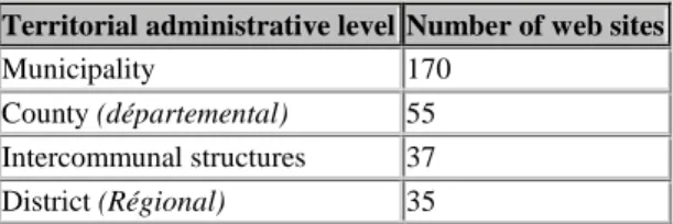
Table 2: Number of web sites for each territorial level Territorial administrative level Number of web sites
Municipality 170
County (départemental) 55 Intercommunal structures 37 District (Régional) 35
It is necessary to specify that the sum of the values of table 2 does not make 444. Indeed, we introduced into the table 2 only the Web sites which had at least one link towards one of the 443 other sites.
Several elements can be extracted from the tables of calculation of the chi two:
- The municipalities’ web sites have much less relations between them than they could have taking into account the number of their class. Conversely, the Web sites depending on the District level on the one hand, or county level of the other, have much stronger relations between them. That means maybe that the Web sites from the district level for example, have similar referents, and that this similarity is reproduced with the hypertexts links.
- It is observed that the Web sites of municipalities or intercommunal structures level are more numerous to point to the County or District Web sites that the reverse. If one agrees on the fact that the hypertext relation means recognition, it is in this case a system in which there is recognition by the local level Web sites of the County and District level Web sites legitimacy. That means also a contrario that the Web sites of District and County level do not play as a whole, their role of directing towards local resources.
4.2 Analyze of the counties scale (Départements)
4.2.1 Inter-counties interactions analysis: The municipalities Web sites focus
In this part, we suggest to focus on the municipalities Web sites within each county, by emphasizing the interactions which exist between them. The final objective is to represent the interactions between municipalities Web sites on a georeference system in order to reveal a superposition between physical geography and virtual geography.
Let us put our attention from now on in the relations between the municipalities Web sites, and let us present these interactions on a geographical chart. We obtain then the graph presented in the figure 2.
Figure 2: Georeference representation of the interactions between Municipalities Web sites.
This graph illustrates a strong connection to the physical territory. We also observed that the hypertextual interactions between Municipalities Web sites are related to Municipalities that are located in the coast. But this is to be put in parallel with the statistics of the municipalities having a Web site and which are particularly numerous in the same fringe littoral.
The geographical representation of the Web sites located in the PACA District makes it possible to emphasize the existence of three large poles of interconnections. The first is in the Rhone valley, the second is around Marseille and the third is in the South of the Alps Maritimes around Nice.
Firstly, what we can deduce from it is that the links within these three large poles are very brought closer between them. We can thus once again note a physical reality on the ground.
However, we can observe different realities within these poles: As regards to the Rhone valley, the large cities of Avignon, Aix en Provence and Marseille, seem to play a decisive role directing towards other contiguous Cities and Towns.
Regarding to the pole of the neighbourhoods of Nice, the situation is quite different. It acts rather of a reciprocal exchange between several cities which return links in turn, without showing any other general tendency. Then, it would be interesting by examining the nature of these links, to consider the factors which explain these differences in behaviour.
The case of the pole of Avignon is interesting because this pole is located at the limit of other Districts and Counties areas, and we can notice that the emergent links are rather numerous to turn to the PACA Municipalities.
Adjoining to the statement operated before about physical reality that the links shows, it would be advisable to analyze the whole of the links starting from the Web site of the town of Avignon to observe if the extent of
these links relates to the Municipalities as much for the bordering cities outside Paca than inside. That will add a response to another observation which is that of the political or administrative relevance of the Web presence. It will confirm or cancel the reports that we can already bring on the inside counties interactions Web sites behaviours.
The valley of the Rhone connected to the agglomeration of Aix en Provence and Marseille:
Other interesting elements are the two Avignon and Marseille poles which are rather clearly connected between themselves. The connections are sometimes based on cities acting as transitional passages. We can call the cities as “bridge cities”. Hence, it is relevant to superpose that on its physical context. This zone corresponds to a major axis of road and railway infrastructures. Moreover theses zones also represent considerable economic poles.
The question that we would consequently be brought to ask would be: how was the emergence of these virtual links structured? Were there grafted naturally on a certain number of real and physical existing factors, or is the emergence of an independent and strategic determination that facilitated the new means of communication?
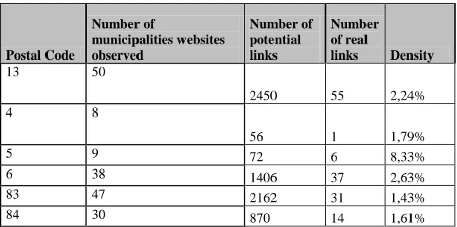
To appreciate the importance of the network we applied in table 3 the indicator of density, well-known in the social networks analysis field (Wasserman and Faust, 1994), (Degenne and Forsé, 1994). In the level of a territory, this indicator is defined as the existing relationship between the number of hypertexts links observed and the maximum number of observable hypertexts links. For example, for the department of the Bouches du Rhône, we can observe 55 real hypertexts links between the 50 existing Web sites on a total of 50*49 hypertexts links. By reporting these two figures we obtain a density of 2,24%.
The result is for each County a relative weak density.
We notice that the counties which have the most numerous equipped Web sites Municipalities are not inevitably the counties which have the strongest density. This density is rather similar for the counties most equipped (13, 83, 06, 84), while it is disparate for the counties less equipped (04 with low density, and 05 with strong density).
Table 3: hypertexts link density between counties
Postal Code Number of municipalities websites observed Number of potential links Number of real links Density 13 50 2450 55 2,24% 4 8 56 1 1,79% 5 9 72 6 8,33% 6 38 1406 37 2,63% 83 47 2162 31 1,43% 84 30 870 14 1,61%
4.2.2 Intra-counties interaction analysis: The creation of the networks inside the counties
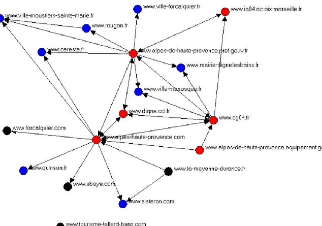
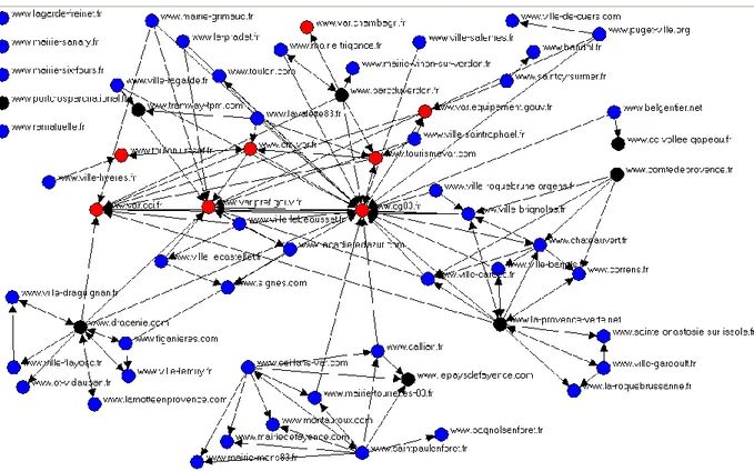
We were interested then, to refine the analysis, with the interactions between web sites of a given County. We initially considered the existing interactions between the Web sites of the County of the Alpes de Hautes Provence. We made a focus on the interactions of all the Municipalities and intercommunal structures Web sites of this county. We then represented the network of the interactions between all these sites. This network makes it possible to understand the relative position of the actors. We thus obtain the graph of figure 3 which can be the object of various interpretations.The blue tops indicate the Web sites of Municipalities, the blacks the sites of intercommunal structures, and the reds the Web sites of county level.
This graph shows us the central part played by some institutional Web sites like those of the County Prefecture, the General Council or the Chamber of Commerce. These few Web sites are located in the heart of the network and allow all the other Web site to be connected thought them.
Figure 3: Interactions between Web sites within the Alpes de Hautes Provence County
We then reproduced the same analysis on the level of the other counties as with the Var County for example. The network obtained is this time much denser, but the heart of the network is composed of the same institutional Web sites as it is showed in figure 4. Moreover, if these institutional Web sites are removed, we observe a much more readable graph presented figure 5, and cut out in several disjoined zones. These Web sites which appear federator are however misleading, because they almost all belong to the "authorities" type. That means that these Web sites do nothing but receive hypertext links on behalf of other sites, without emitting to other Web sites.
That confirms a former opinion in which we said that these institutional Web sites did not direct towards the resources of the territory, but that they appear as wells towards which one arrives quickly when a research is made, without always being able to evolve to other Web sites thereafter.
There is an organization of independent networks around the Web sites of Intercommunal Structures. Not only the Web sites of Intercommunal Structures form part of these independent networks, but there is a network dynamism around the Municipalities which make it up. The network becomes denser, when two Intercommunal Structures superimpose themselves partly, and shares certain entities within their composition.
Figure 5: Interactions between web sites within the Var County (after filtering)
5. CONCLUSION
On the networks devices of a territory informational structures (like the cover of the broad band internet for example), a whole of networks is superimposed, generated by the correlation of the resources placed at the disposal, but this time on the Internet. Our study made it possible to highlight these sets of networks on a defined territory, in order to represent them in a tangible way.
One of the purposes of this study was to observe how the network is organized for the political organizations on the internet through hypertext links. The entire web is characterized both by a wilful attitude and disorganized information that affect also the constituted network. We voluntary did not distinguish both aspects in order to focus on the results and consequences more than the intentions that influenced or not the creation of these links.
After having taken into account the limits that such an analysis can imply (which is in a complex environment, mixing at the same time physical and virtual dimension), we could defined some tendencies and took part in an outline of the evaluation of their consequences.
The more modest the entity is (from the Municipality level to the District level), more it finds itself cut from the entities of the same size and reveal themselves insulated.
Information as for it, may be qualified unanimously, of "ascending" information, i.e. the links are generally generated by small structures which point towards higher territorial levels. It would be advisable from now on to determine which are the elements that generate such “ascending" information, and thus direct the visitors towards specific institutions more than others of the same level or even lower.
On the opposite, the institutions which have a regional radiation on the scale of the whole of the PACA District, benefit from some footbridges, but do not play their role directing towards structures of more modest scale and with a public more geographically targeted.
It arises from the charts, that Web sites hinges are proven, around of which revolve a certain number of Web sites, most frequently sharing a common identity or a physical reality. It is often the case of the
Municipalities Web sites which are born from an authentic project emphasized by parallel actions on the ground.
The Web sites contribute to promote and facilitate the coordination of these projects. There is thus interdependence between the installation of concrete projects and the sharing of on line resources.
We finally can consider that the induced and not yet exploited potentialities by the actors network strategies in the field of the public administrations, can maturate and improve in the years to come. That can be around projects which are based on real coherency and desire of information homogeneity that would need long term perspective whatever the territorial domain is and in a transparent way for the end user.
REFERENCES
BookDegenne A., Forse M., (1994), Les réseaux sociaux, Editions Armand Colin, 1994.
Gervais B (2002), Naviguer entre le texte et l'écran. Penser la lecture à l'ère de l'hypertextualité, Communication, colloque "Les défis de la publication sur le web", Quinzièmes entretiens du Centre Jacques Cartier, decembre 2002, Lyon. 03.
Le Grand Robert de la langue française, second edition, 1986, Tome V. Longman Dictionary of Contemporary English, third edition, 1995.
Grivel L, (2000), L’hypertexte comme mode d’exploitation des résultats d’outils et méthodes d’analyse de l’information scientifique et technique., Thèse de doctorat, Université de droit, d’économie et des sciences d’Aix Marseille. UQAM, (1996), Dictionnaire des arts médiatiques, Groupe de recherche en art médiatique.
Wasserman S., Faust K. (1994), Social Network Analysis: Methods and Applications. Cambridge, England, and New York: Cambridge University Press.
Journal
Egghe L. (2000), New informetrics aspects of the internet: some reflections, many problems, journal of information Science, 26(5): 329-335.
Ertzscheid O, (2005), Article paru dans le supplément spécial « Perspectives 2005 », Le Monde, January 5, 2005
Rostaing H, Boutin E., Mannina B. (1999), Evaluation of internet resources: bibliometric techniques applications. In cybermetrics 99, Colima.
Conference paper or contributed volume
Bertacchini, Y., (2002), Redéfinition des territoires de la communication, Bucarest, 2001. June 24, 2002.
Belisle C. (1998), Navigation et hypermédia. Séminaire DAFCO, " L’apprentissage médiatisé ". Lyon : Institut des sciences de l'homme.
Boutin Eric, Mannina Bruno, Rostaing Hervé, Quoniam Luc, " Construction automatique de réseaux : un outil pour mieux appréhender l'information provenant de l'internet " 4èmes journées internationales d'analyse Statistiques des données textuelles, JADT 1998, Nice, 1998
Clément J., in: Encyclopedia Universalis : Paris : Encyclopedia Universalis 2005.
Ding C., Zha H, He X., Husbands S P., Simon H. ( 2001) “Link Analysis : hubs and authorities on the world wide web”, LBNL.