A preliminary study of cross correlation between lithology and K airborne
radiometry in the Belgian Ardennes
Jean-Christophe Maréchal*, Enrico Bonino**, Yves Vanbrabant*, Hervé Teerlynck*,
Eric Pirard** and Denis Jongmans*
*Laboratories of Engineering Geology, Hydrogeology and Geophysical Prospecting, Liège University, Bât. B19, Sart-Tilman, B-4000 Liège, Belgium
**MICA Laboratory, Geomaterials Characterisation, Liège University, Bât. D2, Avenue des Tilleuls 45, B-4000 Liège, Belgium
[email protected], [email protected], [email protected] , [email protected], [email protected], [email protected]
ABSTRACT
The K-radiometric data measured by airborne survey in Belgium were kriged on a part of the Belgian Ardennes. The experimental semivariograms show the anisotropy of these data in accordance with the geological orientation. The comparison of the gridded data and the geological map of the region shows a very good agreement which indicates the control of rock lithology on the radiometric measurements. The K-radiometric signatures for each lithological unit were computed and compared. The K-Feldspar and mica content is the key factor influencing the data. Radiometric data, which are continuous and relatively easy to obtain on a large scale by airborne survey, have been successfully used as an image for improving the geological knowledge of a region.
KEYWORDS
Radiometric data, Potassium, Ardennes, Lithology.
INTRODUCTION
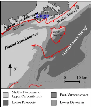
Large scale and continuous geophysical data are unfortunately rare. Consequently, it is important to exploit their potential when they are available. In 1984, an airborne survey covered Belgium to measure the K, U and Th radiometric data, with a final gridding resolution map of 200 m (Service Géologique de Belgique, 1994). A first overview of the data at the country scale shows a good correspondence between these data and the geology. While this is true both in the northern part and in the southern part of Belgium, the latter is characterised by a more contrasted geology with rock outcrops. The object of this paper is to illustrate the interest of radiometric data in Paleozoic rocks on an area of the Belgian Ardenne. Owing to the difficulty to manage a too large number of data, the study was limited to an area of about 2000 km2, to the South of Liege (Fig. 1). This zone clearly illustrates the large diversity of the Ardenne geology.
GEOLOGY
The studied area is localised along the northern frontal zone of the Variscan orogenic belt. At the end of Westfalian times, the deformation affected Lower Palaeozoic clastic sediments which essentially crop out within the Stavelot-Venn Massif (Fig. 1), and Devono-Carboniferous clastic and carbonate sediments that can be found in the Dinant Synclinorium and Namur Synclinorium. The other tectonic units are the Theux window and the Vesdre Massif situated on the Northern border of the Stavelot-Venn Massif. All these tectonic units constitute the northern border of the Ardenne allochton which has been overthrusted on a parautochtonous unit formed by the Namur Synclinorium and the Caledonian Brabant Massif. The limit between theses two major tectonic structures is the Midi-Eifel-Aachen thrust complex. In the central part of the studied area, the Xhoris thrust affects both the Stavelot-Venn Lower Palaeozoic sediments and the Devonian sediments of the Dinant Synclinorium.
Dinan t Sync linorium Stav elot -Ven n M assi f Vesd re M assif Theux Window Eifel T hrust
Liege
0 10 km NLower Paleozoic Lower Devonian
Post-Variscan cover Middle Devonian to Upper Carboniferous Namu r Sync linori um
Figure 1: Simplified geological map of the zone
The stratigraphic column used in this paper is due to de Bethune (1961) who draw up a synthetical geological map of Belgium. The author distinguishes two stratigraphical groups for the Stavelot-Venn Massif : the Devillian-Revinian group (Cambrian) which are constituted by mixed quartzite-slate layers, and the quartzite-slates of the Salmian group (Lower Ordovician). In the south of the Xhoris thrust, Lower Devonian clastic sediments are classified in the so-called Gedinnian (Lochkovian), Siegenian (Praguian) and Emsian stages, while to the north of this fault the three stages are grouped in a common Lower Devonian unit.
Table 1 - Stratigraphical separation for the Middle and Upper Devonian sediments used in this paper (de Bethune, 1961).
Dinant Synclinorium Theux window –
Vesdre Massif – Namur Synclinorium Upper Famennian sandstones Frasnian-Famennian shales Middle to Upper Devonian units Mixed clastic and
carbonate sediments Of the Middle Devonian and Lower
Frasnien
As shown in Table 1, de Bethune (1961) also distinguished, on the one hand, three formations for the Middle and Upper Devonian sediments of the Dinant Synclinorium, and, on the other hand, one Middle to Upper Devonian unit for the Theux Window, the Vesdre Massif and the Namur Synclinorium. The Dinantian limestones are not differentiated between the different tectonic units. Upper Carboniferous rocks, which mainly crop out in the Namur
Synclinorium, are composed of sandstone, shale and coal layers.
Undeformed Post-variscan sediments crop out here and there on the Palaeozoic rocks. A supposed Permian age carbonated conglomerat crops out in the centre of the Stavelot-Venn Massif. This one and the Dinant Synclinorium are locally covered by some remains of Cretaceous and Tertiary deposits preserved from erosion and by Quartenary alluvial sediments. In the northern part of the map (Fig. 1), thick Mesozoic and Cainozoic sediments cover the variscan rocks except along the Meuse valley which is filled by alluvial deposits.
RADIOMETRIC DATA ANALYSIS
The acquisition of the spectrometric data was carried out by means of an airborne survey. The spectrum, whose energy is from 0 to 3 MeV, is recorded on 256 channels over an integrated time of 1 second at a plane speed equal to 250 km/h (approx. 70 m sampling). The conventional method of acquisition and processing of spectrometric data is to focus the interest on four relatively broad spectral windows centred on the peaks of energy of potassium (K), uranium (U), thorium (Th) and total counting (TC). In this work, the accent is laid on the potassium window (1,35 to 1,57 MeV) for which the correspondence with geology is most spectacular. The investigation depth is a few centimetres. The shape and the intensity of the gamma radiation recorded in airborne surveys are influenced by many external causes. The role of processing is to correct the data for these disturbances independent of geology (Ulaby et al., 1981). The characteristics of the corrections are the following ones : cosmic and aircraft background removed, live time corrected, temperature corrected, Compton effect corrected and height attenuated to 120 m. The approximate equivalence coefficient is : 1 cps = 0,0085 %K = 2,673 Bq/kg.
A GPS positioning system was used to locate the data points in the Belgian Lambert projection. The lines of flight are directed roughly North-South with a spacing of 1 km. Perpendicular lines (roughly West-East) cross the principal lines every 10 km. In the studied area, for about 2000 km2 the number of data points is 34822, corresponding to 17 points per km2.
STRUCTURAL ANALYSIS
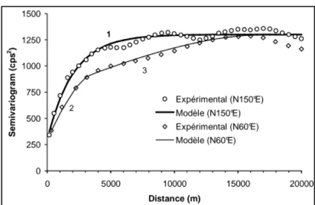
The spectrometric data are characterised by an anisotropy due to the preferential orientation N 60°E of geological structures. Two perpendicular experimental semivariograms (N 60°E and N 150°E) have been computed in order to take into account anisotropy (Fig. 2).
0 250 500 750 1000 1250 1500 0 5000 10000 15000 20000 Distance (m) S e m iv a ri o g ra m ( c p s 2) Expérimental (N150°E) Modèle (N150°E) Expérimental (N60°E) Modèle (N60°E) 1 2 3
Figure 2: Experimental and model semivariograms.
The semivariogram oriented along the geological structures (N 60°E) can be adjusted by the combination of two spherical models while the second semivariogram (along the direction N 150°E) needs only one exponential model. The anisotropy clearly appears on the second semivariogram across geological structures which is characterised by a periodic structure. Their characteristics are summarised in Table 2.
Table 2 - Characteristics of the directional experimental semivariograms.
Parameters Semivariogram 1 Semivariogram 2
Direction N 60°E N 150°E
Tolerance ± 10° ± 10° Variance 1171 1171 Mean 97 97 Nugget C0 = 300 C0 = 300 Model 1 Spherical (C1 = 460; R1 = 3400 m) Exponential (C1 = 1000; r1 = 2050) Model 2 Spherical (C2 = 540; r2 = 17430 m)
LITHOLOGICAL ANALYSIS
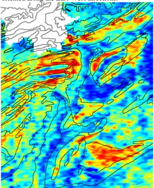
The relationship between radiometric data and geology is obvious, as shown in Fig. 3. The different structural units of the area can be easily distinguished. The Theux Window, the Southern part of the Stavelot Massif, the succession of formations in the Dinant Synclinorium are as many structures appearing on the radiometric map.
A systematic statistical analysis has been applied to determine the radiometric signature of each geological unit. The principle of this method is to extract the radiometric data in each geological unit and compute the mean and standard deviation values of these data (Table 3). The dominant lithology is associated to an age (lithochrono-stratigraphic), although a lithostratigraphic approach should be more suitable.
Most geological units are characterised by K mean values ranging between 83 and 92 cps. These values stay close to the mean of the entire zone (97 cps). Four higher mean value zones appear in the Middle, Upper Devonian and Salmian rocks of the Ardenne. The highest value of the Upper Famennian sandstone (129 cps) can be explained by a rich K-feldspar content. Thorez and Dreesen (1986) observed that this sandstone has an arkosic composition with a feldspar content between 5 to 50% depending on the formations. The high-K value inside this unit can also be partially explained by the presence of a high amount of detrital white mica. The shales of the Frasnian-Famennian limit and the Salmian slates contain a lot of phyllitous minerals rich in potassium: they have consequently a high value (respectively 125 and 121 cps). In the Theux Window, the Vesdre Massif and the Namur Synclinorium, the Middle and Upper Devonian unit has a higher potassium content (120 cps) due to the presence of the Upper Famennian arkosic sandstone and to the shale of the Frasnian-Famennian limit, but the presence of the Frasnian limestone and the detrital Givetian rocks reduce the mean value of this unit. The latter observation may be constrained by higher K-content zones near the contact with the Dinantian terrains which are stratigraphically close to the Upper Famennian sandstones. In the Dinant Synclinorium and the Vesdre Massif, the carbonated Dinantian rocks have a relatively weaker value than their neighbour rocks. The carbonated digitations appear like negative anomalies among the Middle and Upper Devonian units in the Dinant Synclinorium. However, the relatively high mean value of Dinantian carbonated rocks (106 cps) in comparison with all the geological units is surprising. Middle Devonian (Couvinian-Givetian) and Lower Frasnian (Upper Devonian) units have a behaviour similar to the Dinantian rocks. Their content in carbonated rocks contributes to decrease the K-value in the Southern part of the Dinant Synclinorium. All Lower Devonian and post-Variscan units show a relatively low K-content. The Quaternary river sediments are close to the general mean value of the studied area.
Table 3- Statistical characteristics (cps) of the kriged K radiometric data in the different geological units.
Geological unit : lithology, « age », (location) Mean Std.Dev.
Sandstone of the Upper Famennian (Dinant Synclinorium) 128.7 25.7
Shale of the Frasnian-Famennian limit (Dinant Synclinorium) 125.4 23.4 Slate of the Salmian : Ordovician (Stav. Msf, Sambre and Meuse zone, Brabant Msf) 120.9 29.7 Clastic and limestone of the Mid. and Upper Dev. (Th. Wind., Vesd. Msf and N. Syncl.) 119.8 28.1 Clastic and limestone of the Mid. Dev. + Limestone of the Low. Frasnian (D. Syncl.) 107.6 22.6
Limestone of the Dinantian 106.5 30.3
Clastic sediments of the Emsian (South of the Xhoris Thrust) 91.8 16.6
Shale-Sandstone-Coal of the Silesian 91.6 15.0
River sediments of the Quaternary 90.7 22.4
Conglomerate of the Permian (Stavelot Massif) 88.7 15.4
Slate and quartzite of the Devillian-Revinian : Cambrian (Stav. Msf and Th. Wind.) 88.1 28.0
Chalk and flint of the Upper Cretaceous 87.4 16.9
Clastic sediments of the Siegenian ≈ Praguian (south of the Xhoris Thrust) 85.7 20.6 Clastic sediments of the Gedinnian ≈Lochkovian (south of the Xhoris Thrust) 85.5 24.3 Clastic sediments (shale and sandstone) of the Lower Dev. (north of Xhoris Thrust) 83.6 20.0
Sand of the Tertiary 72.3 23.4
Entire zone 97.3 34.2
GRIDDING
Kriging as an interpolation method is particularly suited for irregular data sets such a the ones resulting from a geochemical survey. In the present case, kriging was applied on potassium values to get a regular map (figure 3) illustrating the correlation between lithology and radiometric data. Simple kriging has been performed with a maximum of 100 nearest points taken into account, a search radius equal to 7000 meters and an anisotropy of 0.25 (with the major axis oriented along the East-West direction).
Figure 3. K-radiometric kriged map overlaid on lithological boundaries in the Belgian Ardenne.
CONCLUSIONS
The geostatistical methodology applied in this preliminary study has allowed to quantify and compare the K-radiometric signature of each geological unit of the studied zone. It confirms the strong influence of the geological setting on radiometric data. In countries where geological data are rare, this method can be useful to obtain a rapid and cheap geological overview. In Belgium, such an approach is most suited to irregular data such as geochemical ones in order to study their structure and properties.
REFERENCES
de BETHUNE, P. 1961. Géologie - commentaire de la planche 8 de l’atlas de Belgique. Académie royale de Belgique, Comité national de Géographie, 47 p.
THOREZ, J. & DREESEN, R. 1986. A model of a regressive depositional system around the Old Red Continent as exemplified by a field trip in the Upper Famennian « Psammites du Condroz » in Belgium. Ann. Soc. Géol. Belg. 109, 285-323.
SERVICE GÉOLOGIQUE DE BELGIQUE, 1994. Spectrometry. Potassium Count Image Map. 1:500 000.
ULABY, F.T., MOORE, R.K. & FUNG, A.K., 1981. Fundamentals of radiometry. Dedham: Artech house, 456 p.