HAL Id: hal-00831895
https://hal-mines-paristech.archives-ouvertes.fr/hal-00831895
Submitted on 8 Jun 2013
HAL is a multi-disciplinary open access
archive for the deposit and dissemination of sci-entific research documents, whether they are pub-lished or not. The documents may come from teaching and research institutions in France or abroad, or from public or private research centers.
L’archive ouverte pluridisciplinaire HAL, est destinée au dépôt et à la diffusion de documents scientifiques de niveau recherche, publiés ou non, émanant des établissements d’enseignement et de recherche français ou étrangers, des laboratoires publics ou privés.
Coregistration of DSM and 3D Point Clouds Acquired
by a Mobile Mapping System
Taha Ridene, François Goulette
To cite this version:
Taha Ridene, François Goulette. Coregistration of DSM and 3D Point Clouds Acquired by a Mobile Mapping System. Boletim de Ciências Geodésicas, Universidade Federal do Paraná, 2009, 15 (5), pp.824-838. �hal-00831895�
COREGISTRATION OF DSM AND 3D POINT CLOUDS
ACQUIRED BY A MOBILE MAPPING SYSTEM
Corregistro do DSM e nuvem de pontos 3D adquiridos através de um sistema de mapeamento móvel.
TAHA RIDENE FRANÇOIS GOULETTE
Mines Paristech, Caor- Centre De Robotique Mathematiques Et Systemes
60 Bd Saint Michel 75272 Paris Cedex 06, France Emails: [email protected]
[email protected] Tel: 01 40 51 93 27 (92 35) - Fax: 01 43 26 10 51
ABSTRACT
The development of 3D mapping databases is a matter of increasing interest. Databases have recently been developed at different scales (national, European, international) and to meet different needs. Such development has been made possible by the implementation of efficient 3D mapping technologies. 3D mapping strategies are based on multi-sensor data fusion usually performed after a preprocessing step that includes registration and filtering. In this paper, we present our work on registration methods applied to solve problems in 3D urban environment representations issued from a Mobile Mapping System. We improve the stability of convergence, the computation time and handle heterogeneous data sets in various scenarios.
Keywords: 3D Registration; ICP; Mobile Mapping System; Point Clouds; DSM. 1. INTRODUCTION
The production of realistic 3D map databases is a matter of increasing interest. Databases have recently been produced on different levels (national, European, international) for different applications. Different methods have been used to develop such Databases. The expansion of this development has been made possible by the implementation of efficient 3D mapping technologies and rapid progress in various fields such as remote sensing, image processing and sensor technologies (camera, laser, GPS, INS, etc.). A variety of efficient Mobile Mapping Systems
(MMS) has been produced to create 3D models of cities. MMS are special vehicles which integrate two kinds of sensors: “positioning sensors” (GPS, INS, Compass, etc.) and “imaging sensors” (camera, laser, radar, etc.). Acquisition with MMS can be carried out using two methods: “driving” and “stop and go.” In our approach, after the data acquisition step we processe the resulting datasets using algorithms of multi-sensor data fusion to obtain 3D representations. These phases of the work (acquisition, processing) require the use of specific software such as RT-Maps (Nashashibi et al., 2000) which generates timestamped data bases.
Most land MMS use “direct geo-referencing,” a category which can be divided into two sub classes: (1) laser-based (Goulette et al., 2006, Zhao and Shibasaki, 2003); (2) photogrammetry-based (Bentrah et al., 2004, Pollefeys et al., 2008).There are, however, also MMS using “indirect geo-referencing” (Früh and Zakhor, 2004). The results produced by MMS depend on the sensors used. A comparative study between MMS can be found in (Ellum and El-Sheimy, 2002, Schwarz and El-Sheimy, 2004).
1.1 Context
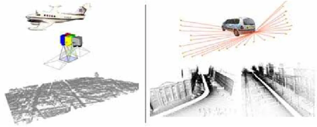
The overall project goal is to generate realistic and geo-referenced 3D maps of urban areas around Paris. We use mainly our Mobile Mapping System (MMS) Lara3D (Goulette et al., 2006) presented in Figure 1.
Figure 1 – (Left) Digital Surface Model (DSM) obtained by correlation between aerial images with 20x20 cm horizontal resolution. (Right) Lara3D, a Mobile Mapping System using a coupled laser scanner/fish eye camera vision system. The
resolution of 3D point clouds obtained is 20 cm between profiles and 10 cm between points in the same profile.
In the present work we made acquisitions using Lara3D in the 5th district of Paris. These acquisitions were made in “driving mode” and planned by road
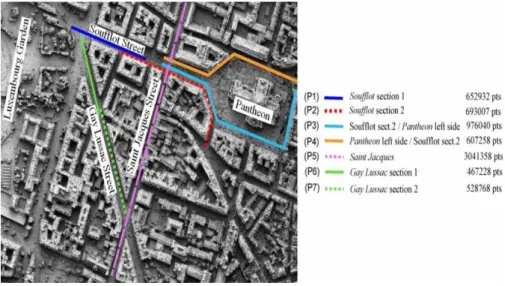
sections. In fact, in a dynamic urban environment with obstacles (cars, streetlights, etc.), it is impossible to treat all sections of the area at once. A series of acquisitions must thus be made. The resulting set of separate acquisitions generates incoherence in the data produced (i.e Figure 2) due to problems that can affect sensors (GPS multi path error, GPS masking, INS drift, etc.). Despite geo-referencing, we observe offsets and deformations between datasets. To obtain a correct model at the end of processing, we have to apply registration of the datasets before carrying out the fusion step. Making a correct registration requires 3D reference data. We have two possibilities: (1) register overlapped road sections in pairs; (2) carry out registration by using external 3D representations as references. In our case we used a Digital Surface Model (DSM) (i.e Figure 1). In fact, DSM is the most extensive for this area and provide the best geo-referencing in absolute terms: resolution (20x20x50 cm) in (X,Y,Z). This combination between DSM and MMS point clouds is useful for the final model. The main contribution of the fusion between these two 3D representations lies in the fact that they complement each other. For example, roof information that not accessible by MMS acquisitions can be recovered from aerial data (DSM) just as the ground track of buildings hidden by edges of roofs in a DSM will be accessible by the MMS data set.
Figure 2 – Overlapping of all road sections produced by Lara3D around the
Pantheon monument (each road section with a specific color). Three different
viewing angles are presented. We observe problems of coherence between road sections due to the localization problem of MMS in the urban environment: GPS
multi path error, GPS masking, INS drift.
1.2. Contributions
In order to realize registration, several 3D registration methods have been proposed in the state of the art, however, the motivation of our work is to propose automatic 3D registration method for processing of heteregeneous datasets and to
resolve instability problems that can influence registration processing. The large amount of data processed need a huge computation time, which can represent a limitation in practical cases. Our implementation has to be fast.
The main contributions of this paper can be stated as follows. First, we present a variant of rigid registration based on ICP with preprocessing and dynamic threshold updating. This variant is adapted to our heterogeneous datasets that have different amounts of geometric features along with different resolutions and levels of precision captured using two different techniques (Mobile laser scanner and DSM). Our method uses two different adjustment techniques appropriate to the cases studied. Second, a classification of cases of registration related to the kind of overlap which makes it possible to improve the performance of the algorithm and to set the input variables. Third, we show how the registration with an external 3D representation such as DSM can correct the incoherence for 3D models produced by a Mobile Mapping System.
This paper is organized as follows. In section 2 we present a state of the art of rigid registration and our implementation is described. In section 3 the experimentation relating to identified scenarios and results are shown. We then present our conclusions and perspectives for future works.
2. REGISTRATION 2.1 State of the Art
Rigid registration consists in estimating a rigid transformation between two datasets which provide a representation in the same referential. To register three-dimensional representations, the most widely-used approach is the Iterative Closest Point (ICP) introduced by (Besl and McKay, 1992, Chen and Medioni, 1992, Zhang, 1994). In the ICP algorithm described in (Besl and McKay, 1992), two main steps are provided: generation of a set of matching pairs and estimation of rigid transformation. In the former each point in one point cloud is matched with the closest point in the other point cloud to form correspondence pairs. In the latter a point-to-point (P-to-P) error metric is used, in which the sum of the squared distances between points in each correspondence pair is minimized by rigidly moving one of the point clouds. These two steps are iterated until stabilization (the error becomes smaller than a threshold level or it stops changing). It has been demonstrated that ICP converges to a local minimum, but this convergence is determined by the initialization at the beginning of processing. In the case of urban 3D representations, if all processed datasets are geo-referenced in the same referential, this referencing will be considered as initialization of the ICP.
Different variants of ICP were proposed in previous works related to rigid registration used in different fields of application (computer vision, photogrammetry, artificial intelligence, etc.). Comparative studies of ICP variants were provided in (Rusinkiewicz and Levoy, 2001, Gruen and Akca, 2005, Akca,
2007). However, there is no guarantee that the registration of two 3D point clouds using the ICP will be successful. Registration can fail due to several causes: if the overlap between the two 3D point clouds is small and not determinist, if data input measurement errors are too big or when there is insufficient geometric constraint on the 3D transformation between the two 3D point clouds (for example, when a plane is being registered to a second plane).
2.2. Proposed Registration Method
Preprocessing operators were applied to input datasets:
• 2D Morphological filtering was performed on the DSM to reduce noise, an Alternate Sequential Leveling (Soille, 2003).
• Sub-sampling was performed on MMS point clouds to reduce search space and to focus the registration on the area of interest.
To determinate points of interest we use all points resulting from a preprocessing step as in (Besl and McKay, 1992).
We find the homogeneous coordinate transformation matrix T = [R|t] which has six free motion parameters (3 angles and 3 translation components) that minimizes a registration error between two point clouds using linear equation 2 based on: Euclidian distance and determination of the nearest neighbour according equation 1. The (Horn et al., 1988) method is used to minimize and to determine T.
} { ⎥⎦⎤ ⎢⎣ ⎡ − < = p p j i Dy i p p Thr p i j ' min arg 1 ε (1)
We use point-to-surface (P-to-S) distance (Chen and Medioni, 1992) (i.e Figure 3.b) for registration between MMS point clouds. In fact, the quality of data shows a regular density in 3D and this kind of adjustment can be used. Still, for MMS/DSM registration we use P-to-P distance (i.e Figure 3.a). In fact, the DSM geometry is 2.5D and we have irregularity in the Z axis on the 3D representation. It is thus not possible to use the previous adjustment technique.
∑
=−
+
=
1
11
(
2
i n i iRP
p
N
ε
t
(2) We have established an approach of rigid registration ICP using a dynamic threshold as in (Masuda and Yokoya, 1994, Fitzgibbon, 2003) with duplicate pairs of correspondence removed as in (Almhdie et al., 2007).Initialization was provided on the dynamic threshold according to equation 3 in which “Res” means the resolution of input data and “ ” is a constant.
))
2
(
Re
);
1
(
max(Re
.
s
P
s
P
Thr
Dy=
κ
(3) The large amount of data processed (6 million points in our case) results in huge computation time which can represent a limitation in practical cases. To accelerate our implantation we optimized the search process of nearest neighbors by using a K-D Tree according to (Mount and Sunil, 2006). The computational complexity has thus been reduced from with ( and ) representing the number of points in input point clouds.)) ( . . ( ) . ( 2 1 2 2 2 1nb toO nb nb Log nb nb O 1
nb
nb
2 2.3. Scenarios of RegistrationOur aim was to register MMS point clouds which display problems of coherence. We performed the registration in two steps. Let us denote T1 and T2 two 3D transformation matrices. Firstly, we did a rigid registration between 3D point clouds issued from MMS using the T1 provided by two sections each time. We then did the registration for the final result with DSM using the T2. Equation 4 shows the steps of registration in terms of the transformations used with Presult and referring respectively to the result point cloud after registration and the initial point cloud before registration.
Pinit
i i i i T T Pinit esult ( 1 2) Pr = ° (4) We planned two scenarios of registration:• Registration between MMS datasets: we classified that on three groups according to the kind of overlap (extremity, intersection and partial part). Figure 5 shows all cases of the registration in this scenario.
• Registration of the MMS datasets on DSM: for each registered case of the previous scenario, a reference road section was selected and we performed
registration on the corresponding area on the DSM. The T2 transformation result was then applied for the second road section for each case.
3. RESULTS AND DISCUSSION
We apply registration with a dynamic threshold on 3D datasets of outdoor urban representation. In our processing we distinguish two steps (i.e Figure 4): registration by pairs between MMS point clouds and registration for the reference road section of each registered pair in the previous step with the corresponding area on the DSM. For registration by pairs, the set of registration includes four cases corresponding to different kinds of overlap. The case of P5-P2 with the intersection was not processed due to problems in P5 point cloud quality. In registration for the reference road section the set of registration includes 2 cases. An initial transformation is needed when the input data are too far than each other. We evaluated our results in a comparative study in terms of convergence speed, complexity and average registration error. Initial values for variables required for the processing are presented in Table 1. Table 2 shows the computing time for each case of registration processed. Testing of the algorithm was performed on a PC
Intel(R) Xeon (R) CPU 5130 at 2.00 GHZ with 2 Go of RAM.
Figure 4 – 5th district of Paris, DSM with overlapping of different road sections acquired by Lara3D. Three overlap cases are identified: (a) extremity (1-2; 6-7); (b)
Table 1– Initialization of values for different variables of ICP. Three different initializations were performed according to the use of the case treated.
Variable Error min Kmax
Lara3D/DSM 30 cm 50 100 Overlap on extremity 15 cm 30 100
Partial overlap 15 m 20 100
3.1. Registration Between MMS Point Clouds
For each road section produced by Lara3D it was necessary to carry out registration to correct the geo-referencing. Five cases of registration were processed according to the kind of overlap (i.e Figure 4).
Figure 5 shows an example of registration when we have an overlap on the extremity: the case of Soufflot Street between P1 and P2. The geo-referencing problem is visible and the road sections are not consistent. After registration we obtained coherence between P1 and P2.
Figure 6 displays the algorithm behavior with P-to-P adjustment and P-to-S adjustment. P-to-S adjustment produces a little better result than P-to-P in terms of convergence. In fact in P-to-S the result was established on average error 0.13 m after 25 iterations compared to 0.15 m for P-to-P. Figure 7 gives an example of registration when we have partial overlap: the case of Soufflot Street between P3 and P4. The georeferencing problems can be observed and the road sections show some incoherence. The result after registration is coherente and we obtain a consistence between P3 and P4. Figure 8 displays the algorithm behavior with P-to-P adjustment and P-to-P-to-S adjustment. P-to-P-to-S adjustment produces better and more accurate results than P-to-P in terms of convergence. In fact, in P-to-S the convergence was obtained on average error 0.14 m after 37 iterations compared to 0.32 m after 35 iterations in P-to-P where convergence was not obtained.
We note that the adjustment methods do not influence the results of registration in the case of overlap on the extremity, unlike in the case of partial recovery in which the P-to-S method produces a better and more accurate result than the P-to-P method.
Figure 5 – Soufflot Street registration between P1 (green) and P2 (black). (a) Overlapping of P1 and P2 before registration with extremity overlap. A shift
can be seen (arrows on selected zone). (b) Result of registration: correspondence between P1 and P2.
Figure 6 – Soufflot Street registration between P1 and P2. Progression of the RMS relative to iterations with P-to-P adjustment and P-to-S adjustment.
Figure 7– Pantheon registration between P3 (black) and P4 (green). (a) Overlapping of P3 and P4 before registration with partial overlap. A shift can be seen (arrows on
selected zone). (b) Result of registration: consistence between P3 and P4.
Figure 8 – Pantheon registration between P3 and P4. Progression of the RMS relative to iterations with P-to-P adjustment and P-to-S adjustment.
3.2. Registration Between MMS Point Clouds and DSM
For each registered pair in the previous step we chose a reference road section and then registered it with the corresponding area in the DSM. Two cases of registration were handled: P2-DSM and P6-DSM. Figure 9 shows an example of registration on Soufflot Street P2.
Figure 9 – Soufflot Street P2 in the 5th district of Paris. Result of registration of MMS point clouds on the corresponding DSM area. (Gray) DSM. (Red) MMS
Point clouds before registration. (Green) MMS Point clouds after registration.
We did a filtering on the DSM to reduce noise. We used an initial Tinit transformation to help the algorithm to converge. The result was correct, and thanks to the initialization made according to the method described in (Ridene and Goulette, 09) the result was established on average error 0.32 m after 31 iterations. Figure 10 displays the algorithm behavior with and without initialization.
Figure 10 – Registration between MMS point clouds and DSM on the Soufflot Street P2 area. Progression of the RMS relative to iterations. We use an initial
transformation to help the algorithm to converge.
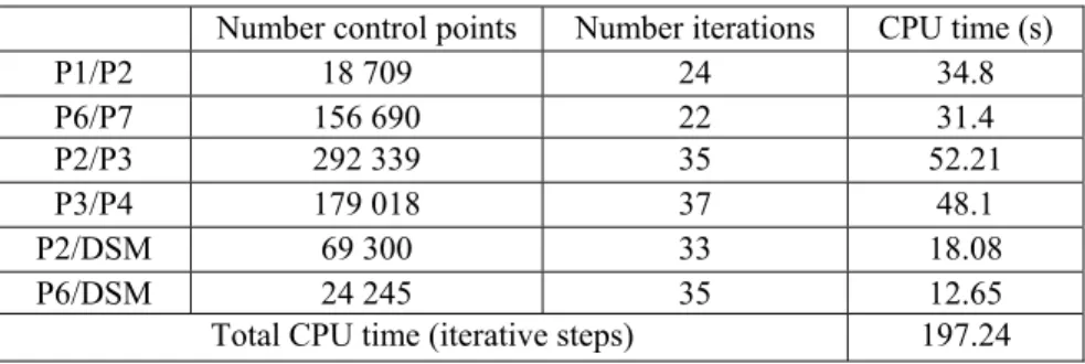
Table 2 – CPU time for optimized implementation of ICP using a K-D Tree. We obtained improvement factor in CPU time of 32 times.
Number control points Number iterations CPU time (s)
P1/P2 18 709 24 34.8 P6/P7 156 690 22 31.4 P2/P3 292 339 35 52.21 P3/P4 179 018 37 48.1 P2/DSM 69 300 33 18.08 P6/DSM 24 245 35 12.65
Total CPU time (iterative steps) 197.24
4. CONCLUSIONS AND FUTURE WORK
In this paper, we have proposed an alternative solution for MMS problems when direct geo-referencing fails. It is based on rigid registration applied between only two point clouds at the same time. The registration is decisive in solving problems which appear when we perform MMS acquisitions in an urban environment. We performed the registration in two steps for 2 scenarios. Firstly, we did a registration between pairs of MMS road sections. Secondly, we performed a registration for reference road sections of each pair registered in the previous step,
with external DSM (3D reference representation). The global result is shown in Figure 11. In our application we processed very large datasets of points (more than 6 million points). To improve the processing time of our implementation we used a K-D Tree. By doing so we obtained acceleration by a factor of 32. A quantitative study based on evaluation of convergence was run to improve the quality of results.
Qualitative registration evaluation is useful as it facilitates comparison between registered trajectories and reference PPK-GPS paths. In the case of accumulation of errors in data issued from positioning sensors (GPS, INS), 3D point clouds resulting from MMS acquisition are affected by local geometric deformations. In such cases, rigid registration fails and cannot give a good result. In such situations, a non rigid registration method must be used to correct geometry of input datasets during the registration process. Figure 12 shows a registration case requiring non rigid registration.
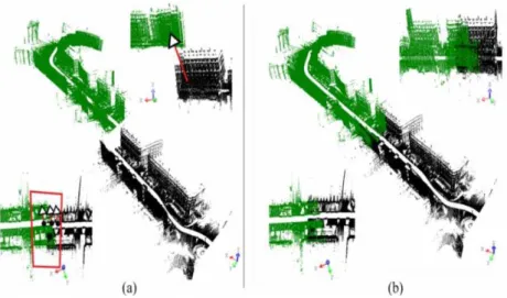
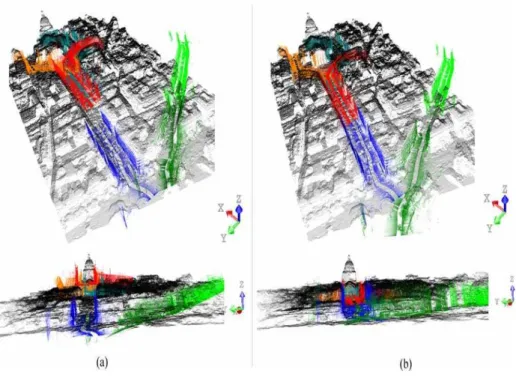
Figure 11 – The area around the Pantheon in the 5th district of Paris. (a) All geo-referenced datasets; we see different offsets between heterogeneous representations.
(b) Final result of coregistration between DSM and 3D point clouds issued from MMS.
Figure 12 – Rigid registration between a point cloud and an aerial photo on Gay Lussac Street in the 5th district of Paris. At the end of the section (part encircled) the result is incoherent and the deformation of the 3D model is clear. One solution
is the correction of the 3D model based on techniques of non-rigid registration.
ACKNOWLEDGEMENTS
The work reported in this paper was partially performed and
sponsored as part of the Cap Digital Business Cluster Terra Numerica
project.
REFERENCES
BRETAR, F. Couplage de Données Laser Aéroporté et Photogrammétriques pour
l'Analyse de Scènes Tridimensionnelles. PhD thesis, MATIS, Ecole National
Supérieure de Télécommunication de Paris, 2006.
BESL P., MCKAY H. A method for registration of 3-D shapes, Pattern Analysis and Machine Intelligence, IEEE Transactions on, vol. 14, no 2, pp. 239-256, 1992.
CHEN, Y., MEDIONI, G. Object modelling by registration of multiple range
images, Image and Vision Computing 10 (3), pp. 145–155, 1992.
ELLUM, C. AND EL-SHEIMY, N. Land-based mobile mapping systems. Photogrammetric Engineering and Remote Sensing pp. 13–17, 2002.
FITZGIBBON, A.W. Robust registration of 2D and 3D point sets. Image and Vision Computing 21, pp. 1145–1153. 2003.
FRÜH, C. AND ZAKHOR, A. An Automated Method for Large-Scale,
Ground-Based City Model Acquisition, IJCV, vol. 60, no 1, pp. 5–24, Springer, 2004.
GOULETTE F., ABUHADROUS I., NASHASHIBI F., AMMOUN S., LAURGEAU C. An Integrated On-Board Laser Range Sensing System for
Photogrammetry, Remote Sensing and Spatial Information Sciences, vol. 34, no Part A, 2006.
GRUEN, A., AND AKCA, D. Least squares 3D surface and curve matching. ISPRS Journal of Photogrammetry and Remote Sensing 59 (3), pp. 151-174, 2005.
HORN, B.K.P., HILDEN, H.M., AND NEGAHDARIPOUR, S. Closed-form
solution of absolute orientation using orthonormal matrices. Journal of the
Optical Society of America A-5 (7), pp. 1128-1135, 1988.
MASUDA, T., AND YOKOYA, N. A robust method for registration and
segmentation of multiple range images. Computer Vision and Image
Understanding 61 (3), pp. 295-307, 1995.
MOUNT, D. AND SUNIL, A. Ann: A library for approximate nearest neighbor
searching. Website. http://www.cs.umd.edu/ mount/ANN/, 2006.
NASHASHIBI, F., STEUX, B., COULOMBEAU, P. AND LAURGEAU, C. RTMAPS a framework for prototyping automotive multi-sensor applications. In: IEEE Intelligent Vehicles Symposium, 2000.
POLLEFEYS, M., NISTER, D., FRAHM, J., AKBARZADEH, A., MORDOHAI, P., CLIPP, B., ENGELS, C., GALLUP, D., KIM, S., MERRELL, P. et al. Detailed real-time urban 3d reconstruction from video. International Journal
of Computer Vision 78(2), pp. 143–167, 2008.
RIDENE, T., GOULETTE, F. Registration of fixed-and-mobile-based terrestrial
laser datasets with DSM. 8th IEEE International Symposium CIRA2009.
Korea, december 2009.
RUSINKIEWICZ, S., LEVOY, M. Efficient variants of the ICP algorithm, Proc. 3DIM, pp. 145-152, 2001.
SCHWARZ, K. AND EL-SHEIMY, N. Mobile mapping systems state of the art and future trends. International Archives of Photogrammetry, Remote Sensing
and Spatial Information Sciences 35(Part B), pp. 10. Soille, P., 2003, 2004.
ZHANG, Z... Iterative point matching for registration of free form curves and
surfaces, International Journal of Computer Vision, pp. 119-152, 1994.
ZHAO, H. AND SHIBASAKI, R. Reconstructing a textured CAD model of an urban environment using vehicle-borne laser range scanners and line cameras.