HAL Id: tel-01717563
https://tel.archives-ouvertes.fr/tel-01717563
Submitted on 26 Feb 2018
HAL is a multi-disciplinary open access
archive for the deposit and dissemination of sci-entific research documents, whether they are pub-lished or not. The documents may come from teaching and research institutions in France or abroad, or from public or private research centers.
L’archive ouverte pluridisciplinaire HAL, est destinée au dépôt et à la diffusion de documents scientifiques de niveau recherche, publiés ou non, émanant des établissements d’enseignement et de recherche français ou étrangers, des laboratoires publics ou privés.
representations : applications to remote sensing data
classification
Yanwei Cui
To cite this version:
Yanwei Cui. Kernel-based learning on hierarchical image representations : applications to remote sensing data classification. Computer Vision and Pattern Recognition [cs.CV]. Université de Bretagne Sud, 2017. English. �NNT : 2017LORIS448�. �tel-01717563�
UNIVERSITE
BRETAGNE
LOIRE
Kernel-based learning on
hierarchical image
representations: applications
to remote sensing data
classification
Soutenance de thèse prévue le 04 Juillet 2017,
devant le jury composé de Luc Brun
Professeur, Ecole Nationale Supérieure d'ingénieurs de Caen (ENSICAEN), France/ Rapporteur
Lorenzo Bruzzone
Professeur, University of Trento, Italie/ Rapporteur Philippe-Henri Gosselin
Professeur, Ecole nationale supérieure de l'électronique et de ses applications (ENSEA), France/ Examinateur
Ewa Kijak
Maître de Conférences, Université de Rennes 1, France / Examinateur Laetitia Chapel
Acknowledgements
I have finished one of the most interesting and challenging experiences during my Ph.D. Here I would like to thank my two wonderful supervisors: Sébastien Lefèvre and Laetitia Chapel, for their companionship. Their guidances and advices helped me to achieve the goals in an efficient way and their critical opinions allow me to think more deeply and more carefully. Thanks also the colleagues in IRISA, especially Nicolas Courty, Bharath Bhushan Damodaran, for the insight discussions and their inspirations. A special thanks for Manoj Joseph Mathew in geology department at UBS for helping me to improve English communication skills and for the joyful moments.
I am very grateful for all the reviewers of this thesis. I appreciate their interests in my work as well as all of their insightful comments and suggestions.
I acknowledge the support of the French Agence Nationale de la Recherche (ANR) under Reference ANR-13-JS02-0005-01 (Asterix project) and the support of Région Bre-tagne and Conseil Général du Morbihan (ARIA doctoral project) for the financial sup-port of the Ph.D. program.
A special thanks for Anne Puissant from LIVE UMR CNRS 7362 (University of bourg) for the warm welcome and discussion during my stay at University of Stras-bourg, also for providing the datasets for evaluating the Ph.D. works.
I also want to express my gratitude to my parents for their unconditional love and support, and my dear friend Zhiying Shen, for the understanding and encouragement that helped me go through the difficult moments.
Abstract:
Hierarchical image representations have been widely used in the image classification context. Such representations are capable of modeling the content of an image through a tree structure, where objects-of-interest (represented by the nodes of the tree) can be revealed at various scales, and where the topological relationship between objects (e.g. A is part of B, or B consists of A) can be easily captured thanks to the edges of the tree. However, for fully benefiting from this key information, dedicated machine learning methods that can directly learn on hierarchical representations and handle the induced structured data need to be developed. In this thesis, we investigate kernel-based strategies that make possible taking input data in tree-structured and capturing the topological patterns inside each structure through designing structured kernels. We apply the designed kernel to remote sensing image classification tasks, allowing the discovery of complex cross-scale patterns in hierarchical image representations.
We develop a structured kernel dedicated to unordered tree and path (sequence of nodes) struc-tures equipped with numerical feastruc-tures, called Bag of Subpaths Kernel (BoSK). BoSK is an instance of a convolution kernel relying on subpath substructures, more precisely a bag of all paths and sin-gle nodes. It is formed by summing up kernels computed on all pairs of subpaths of the same length between two bags. The direct computation of BoSK can be done through an iterative scheme, yield-ing a quadratic complexity w.r.t. both structure size (number of nodes) and amount of data (train-ing size). However, such complexity prevents BoSK to be used on real world large-scale problems, where the tree can have more than hundreds of nodes and the available training data can consist in more than ten thousands samples. Therefore, we propose a fast version of the algorithm, called Scalable BoSK (SBoSK for short), using Random Fourier Features to map the structured data in a randomized finite-dimensional Euclidean space, where inner product of the transformed feature vector approximates BoSK. It brings down the complexity from quadratic to linear w.r.t. structure size and amount of data, making the kernel compliant with the large-scale machine learning context. Thanks to (S)BoSK, we can learn from cross-scale patterns in hierarchical image representations. (S)BoSK operates on paths, thus allowing modeling the context of a pixel (leaf of the hierarchi-cal representation) through its ancestor regions at multiple shierarchi-cales. Such a model is used within pixel-based image classification. (S)BoSK also deals with trees, making the kernel able to capture the composition of an object (top of the hierarchical representation) and the topological relation-ships among its subparts. This strategy allows tile/sub-image classification. Further relying on (S)BoSK, we introduce a novel multi-source classification approach that performs classification di-rectly from a hierarchical image representation built from two images of the same scene taken at different resolutions, possibly with different modalities. Evaluations on several publicly available datasets illustrate the superiority of (S)BoSK compared to state-of-the-art remote sensing classifi-cation methods in terms of classificlassifi-cation accuracy, and experiments on a urban classificlassifi-cation task show the effectiveness of the proposed multi-source classification approach.
Keywords:structured kernel; image classification; hierarchical representations; Random Fourier Features; kernel approximation; large-scale machine learning; remote sensing
La représentation d’image sous une forme hiérarchique a été largement utilisée dans un contexte de classification. Une telle représentation est capable de modéliser le contenu d’une image à travers une structure arborescente, où les objets d’intérêt (représentés par les nœuds de l’arbre) peuvent être appréhendés à différentes échelles et où la relation topologique entre les objets (par exemple “A fait partie de B”, ou “B se compose de A”) peut être facilement décrite grâce aux arêtes de l’arbre. Cepen-dant, pour bénéficier pleinement de ces informations-clés, des méthodes d’apprentissage statis-tiques doivent être développées pour traiter directement les données structurées sous leur forme hiérarchique. Dans cette thèse, nous considérons les méthodes à noyaux qui permettent de prendre en entrée des données sous une forme structurée et de tenir compte des informations topologiques présentes dans chaque structure en concevant des noyaux structurés. Nous appliquons le noyau que nous avons développé aux tâches usuelles de classification des images de télédétection, perme-ttant ainsi de découvrir des modèles complexes dans les représentations hiérarchiques des images. Nous présentons un noyau structuré dédié aux structures telles que des arbres non ordonnés et des chemins (séquences de nœuds) équipés d’attributs numériques. Le noyau proposé, appelé Bag of Subpaths Kernel (BoSK), est une instance du noyau de convolution et s’appuie sur l’extraction de sous-structures de sous-chemins, plus précisement un sac de tous les chemins et des nœuds simples. Il est formé en sommant les noyaux calculés sur toutes les paires de sous-chemins de même longueur entre deux sacs. Le calcul direct de BoSK peut se faire selon un schéma itératif, amenant à une complexité quadratique par rapport à la taille de la structure (nombre de nœuds) et la quantité de données (taille de l’ensemble d’apprentissage). Cependant, une telle complexité ne permet pas d’utiliser BoSK pour résoudre des problèmes à grande échelle, où la structure peut contenir des centaines de nœuds et les données d’apprentissage disponibles peuvent comporter plus de dix milliers d’échantillons. Par conséquent, nous proposons également une version rapide de notre algorithme, appelé Scalable BoSK (SBoSK), qui s’appuie sur les Random Fourier Features pour projeter les données structurées dans un espace euclidien, où le produit scalaire du vecteur transformé est une approximation de BoSK. Cet algorithme bénéficie d’une complexité non plus quadratique mais linéaire par rapport aux tailles de la structure et de l’ensemble d’apprentissage, rendant ainsi le noyau adapté aux situations d’apprentissage à grande échelle.
Grâce à (S)BoSK, nous sommes en mesure d’effectuer un apprentissage à partir d’informations présentes à plusieurs échelles dans les représentations hiérarchiques d’image. (S)BoSK fonctionne sur des chemins, permettant ainsi de tenir compte du contexte d’un pixel (feuille de la représenta-tion hiérarchique) par l’intermédiaire de ses régions ancêtres à plusieurs échelles. Un tel modèle est utilisé dans la classification des images au niveau pixel. (S)BoSK fonctionne également sur les arbres, ce qui le rend capable de modéliser la composition d’un objet (racine de la représentation hiérarchique) et les relations topologiques entre ses sous-parties. Cette stratégie permet la classifica-tion des tuiles ou parties d’image. En poussant plus loin l’utilisaclassifica-tion de (S)BoSK, nous introduisons une nouvelle approche de classification multi-source qui effectue la classification directement à par-tir d’une représentation hiérarchique construite sur deux images de la même scène prises à dif-férentes résolutions, éventuellement selon difdif-férentes capteurs. Les évaluations sur plusieurs jeux de données de télédétection disponibles dans la communauté illustrent la supériorité de (S)BoSK par rapport à l’état de l’art en termes de précision de classification, et les expériences menées sur une
proposée.
Mots clés: Noyau structuré; Classification d’image; Représentations hiérarchiques; Random Fourier Features; Approximation du noyau; Apprentissage à grande échelle; Télédétection
i
Contents
1 Introduction 1
1.1 Context: classification of remotely-sensed images . . . 2
1.1.1 Classification in remote sensing: objectives and challenges . . . 2
1.1.2 Principles of remote sensing classification . . . 3
1.1.3 Main trends for remote sensing image classification . . . 4
1.2 Hierarchical image representations and applications . . . 7
1.2.1 Motivation for hierarchical representations . . . 7
1.2.2 Construction of hierarchical representation . . . 9
1.2.3 Applications in remote sensing . . . 11
1.3 Kernel-based machine learning . . . 13
1.3.1 Kernel definition . . . 13
1.3.2 A kernel method example: Support Vector Machine (SVM) . . . 14
1.3.3 Large-scale learning for kernel methods . . . 17
1.3.4 Structured kernel . . . 18
1.4 Conclusion and organization of the manuscript . . . 19
1.4.1 Motivations and contributions . . . 19
1.4.2 Organization . . . 20
1.4.3 List of publications . . . 21
2 Scalable Bag of Subpaths Kernel (SBoSK) for numerical features 23 2.1 Introduction . . . 24
2.2 Related work . . . 25
2.2.1 Learning on structured data . . . 25
2.2.2 Convolution kernels . . . 27
2.2.3 Large-scale structured kernel . . . 28
2.3 Bag of Subpaths Kernel . . . 29
2.3.1 Basic definitions and notations . . . 29
2.3.3 Kernel weighting and normalization . . . 32
2.3.4 Efficient computation for BoSK . . . 32
2.4 Scalable Bag of Subpaths Kernel . . . 33
2.4.1 Implicit v.s. explicit computation . . . 33
2.4.2 Ensuring scalability using Random Fourier Features . . . 35
2.4.3 Kernel normalization . . . 35
2.4.4 Algorithm and complexity . . . 36
2.5 Conclusion . . . 39
3 Multiscale context-based pixel-wise classification 41 3.1 Introduction . . . 42
3.2 Related work . . . 43
3.3 (S)BoSK on path for multiscale contextual information . . . 45
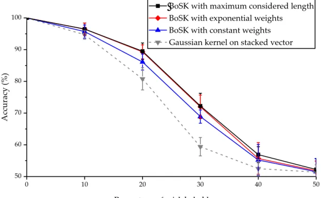
3.4 Experiments on a synthetic dataset . . . 48
3.4.1 Dataset description and experimental setup . . . 48
3.4.2 Overall evaluation of BoSK and Gaussian kernel on stacked vector . . 49
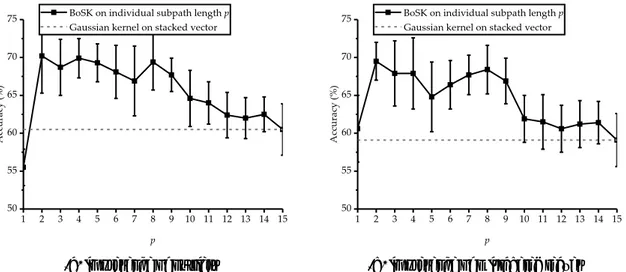
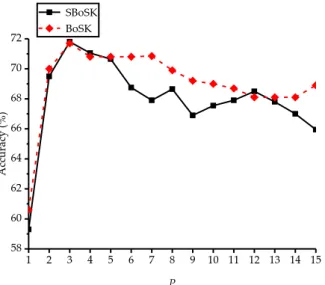
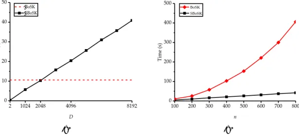
3.4.3 SBoSK analysis . . . 51
3.5 Strasbourg Spot-4 image classification . . . 56
3.5.1 Dataset and design of experiments . . . 56
3.5.2 SBoSK analysis . . . 58
3.5.3 Results and analysis . . . 59
3.6 Hyperspectral images classification . . . 62
3.6.1 Datasets and design of experiments . . . 62
3.6.2 Results and analysis . . . 63
3.7 Large-scale image classification on Zurich summer dataset . . . 66
3.8 Chapter summary . . . 68
4 Spatial decomposition-based sub-image/tile classification 71 4.1 Introduction . . . 72
4.2 Related work . . . 74
4.2.1 Capturing topological information using structured kernel . . . 74
4.2.2 Topological information in hierarchical image representations . . . 75
4.3 (S)BoSK on object spatial decomposition . . . 76
4.4 Experiments on a synthetic dataset . . . 79
4.4.1 Dataset description and experimental setup . . . 79
4.4.2 BoSK analysis . . . 80
4.4.3 SBoSK analysis . . . 82
4.5 Strasbourg Pleiades image classification . . . 85
Contents iii
4.5.2 SBoSK analysis . . . 86
4.5.3 Results and discussion . . . 88
4.6 Large-scale image classification on UC Merced dataset . . . 90
4.7 Chapter summary . . . 94
5 Multi-source and multi-resolution image classification 95 5.1 Introduction . . . 96
5.2 Related work . . . 97
5.2.1 Data fusion in remote sensing . . . 97
5.2.2 Fusion with multiple spatial resolution images . . . 98
5.3 Multi-source images classification . . . 99
5.3.1 Building the hierarchical representation . . . 99
5.3.2 Fusion of (S)BoSK . . . 100
5.4 Evaluation on Strasbourg dataset using both Spot-4 and Pleaides images . . . 100
5.5 Chapter summary . . . 105
6 Conclusions and perspectives 107 6.1 Conclusions . . . 108
6.2 Perspectives . . . 109
6.2.1 Improvements of the proposed methods . . . 109
6.2.2 A step further . . . 111
1
Chapter
1
Introduction
Contents
1.1 Context: classification of remotely-sensed images . . . 2
1.2 Hierarchical image representations and applications . . . 7
1.3 Kernel-based machine learning . . . 13
1.1
Context: classification of remotely-sensed images
1.1.1 Classification in remote sensing: objectives and challenges
Remote sensing is considered as one of the most effective ways for Earth observation. It is generally defined as the technology that measures the surface of Earth from remote, where the acquisition of images can be obtained with some satellite or airborne sensors. Through remote sensing image analysis, we can achieve an accurate identification of materials or even complex objects on the surface of the Earth. Therefore, it provides valuable information for various applications, which include but are not limited to:
• precision agriculture — remote sensing images are used to identify different types of crops and monitor different changes of these crops;
• disaster management — affected areas can be quickly accessed with remote sensing images, providing the possibilities for a rapid damage assessment;
• Urban planning — urban development can be monitored through the remote sensing image archives acquired at different times, with applications like road map updating, or change detection in urban areas.
Although we can acquire a large amount of remote sensing archives every day, images without processing can hardly provide any useful information. One of the most important tasks is image classification, whose goal is to summarize the image into a predefined (ac-cording to some specific applications) list of classes, thus providing fundamental resources that can be easily reused in the next steps of a decision making process. Techniques able to automatically classify images have attracted the attention of researchers for several decades [62, 15, 78]. An example of remote sensing image classification is given in Fig. 1.1.
In the context of remote sensing image classification, several new challenges have emerged because of the recent development of remote sensing sensors:
• High resolution. The challenges raised by high resolution in digital images came from both spectral and spatial domains. In the spectral domain, the hyperspectral image sensors allow the acquisition of the signal in hundreds of spectral wavelengths for each image pixel, which can later provide high discrimination capabilities towards iden-tification of different species or material. However, the resulting images have large correlated dimensions, which induce problems related to the high dimensionality of data especially in the case of limited availability of training samples [15]. Techniques able to effectively exploit the high dimensionality of the images still need to be inves-tigated. Another challenge is related to high spatial resolution. The recent availability
1.1 – Context: classification of remotely-sensed images 3
(a) False color image (b) Ground truth (c) Training samples (d) Classification map
Figure 1.1: An example of pixel-wise remote sensing image classification. The false color compo-sition of hyperspectral image Indian Pines is given in Fig. 1.1a, together with its associated ground truth (mostly unknown for real-world applications) for reference in Fig. 1.1b. After selecting a small number of pixels for training like in Fig. 1.1c, we obtain the classification map given in Fig. 1.1d.
of Very High Spatial Resolution (VHSR) images provides submetric resolution, allow-ing the exploitation of the fine details of the observed scene. Thanks to new sensors, additional information such as texture, shape of complex objects or even structure of the object composition can be better revealed. However, the way to take into account these information remains challenging [62].
• Multi-modal. We face nowadays a large number of sensors with different spatial res-olutions. For instance, we can rely on high resolution sensors such as Quickbird with 0.6 m per pixel, Pleiades with 0.5 m, while low and medium resolution sensors are still in use, e.g. SPOT-4. Multiple remote sensing image sources are available for the same geographical region, and these sources can be fused to improve classification accuracy. In this context, data fusion techniques that can make better use of various source still need to be elaborated [78].
• Large volume. Another challenge is related to the big volume of remote sensing image archives raised by the latest generation of remote sensing sensors. For instance, the average volume of data acquired from a single satellite is about more than 500 GB every day [126]. These data make it possible to monitor Earth at a global scale. However, the efficient processing of such data remains largely unexploited [37, 118].
In this thesis, we address the above mentioned challenges. Readers are referred to [15, 29, 192] for other challenges faced in the field, such as limited availability of training samples, mixed pixels in low spatial resolution images, or domain adaptation. These challenges have not been addressed in this manuscript.
1.1.2 Principles of remote sensing classification
In the context of machine learning, supervised classification aims to find a “rule” based on available data together with their class labels, and use the constructed “rule” to assign new
data to one of the classes. The available data are called training data, which can be repre-sented as(x1, y1),(x2, y2), . . . ,(xn, yn) ∈ X × Y, where xi is the data instance and yi is the associated class label.
The process of remote sensing image classification is composed of data representation, feature extraction, classifier training and prediction. The final quality of the classification depends on the performance of each single step.
The first step is data representation, whose goal is to define what kind of element will be classified and how it will be described (i.e. with which features). In remote sensing, input data can take various forms: image pixels (leading to the so-called pixel-wise classification); regions, commonly used in the object-based image analysis paradigm [36]; or complex struc-tures such as those obtained with hierarchical image representations [17].
Feature extraction step depends highly on data representation. For instance, in pixel-wise classification, a pixel is described by its spectral information encoded in a d-dimensional vector, while region-based classification uses more complex features such as size, shape of the region, or even texture information. In this thesis, we focus on hierarchical representations, where not only the features of regions that are used, but also the hierar-chical relationships among the regions are encoded through complex structured data. We especially focus on tree-based structures i.e. tree and sequence of nodes.
Then we feed the data into a classifier. Various classifiers have been applied for remote sensing classification, which includes K-nearest neighbors [42], Support Vector Machines [139], Random Forests [11, 150], Neural Networks [10] and Deep Neural Networks [94]. SVM is a popular kernel-based method in the remote sensing community and has been in-vestigated for the past 20 years, as its efficiency and capacities to provide high classification accuracies, especially when only limited training samples are available [139]. In addition, it is able to handle complex structured data.
The outputs of classifier (predictions) are generally used directly as the classification map. However, in real world applications, manually editing or automatized post-processing techniques might be applied for generating “smoother” classification maps [13, 183].
Following the standard classification scheme, different research topics are brought into the literature for improving the classification accuracies. The following section gives a brief review of main trends for remote sensing image classification.
1.1.3 Main trends for remote sensing image classification
In this section, we give a brief review of several main trends in remote sensing image classi-fication that are highly related to the problems addressed in this thesis.
1.1 – Context: classification of remotely-sensed images 5
Pixel-wise classification using contextual information
In most of conventional approaches in pixel-wise classification, each pixel is treated inde-pendently. However it is not appropriate, as neighboring pixels are highly correlated and are more likely belong to the same class. This is particular true for very high spatial resolu-tion remote sensing imagery. Due to the recent advances in sensor technology that enable submetric resolution, the spectral variance inside same classes has been highly increased. Conventional techniques that only use spectral information often produce high ratio of clas-sification errors [208]
In the literature, integrating contextual information is considered as one of the key solu-tions to the aforementioned issue. As pointed out in several recent survey papers [62, 76], including spatial contextual information can reduce the labeling uncertainty by exploiting additional discriminant information e.g. the shape and size of different structures formed by neighboring pixels. Moreover, with contextual information, more spatially “smoother” classification maps can be produced.
Contextual information associated with each pixel can be modeled through the neighbor-ing pixels. For instance, in [61], the pixel contextual information is represented as the median of spectral features of the region the pixel belongs to. Another representative example are attribute profiles [76]. They integrate spatial contextual information using morphological filtering around pixels with different attributes, e.g. size, spectral standard deviation, and produce a high dimension feature vector that encodes the changes of each pixel under dif-ferent filterings.
Due to the importance of taking into account contextual information, various pixel-wise classification methods have been adapted in the different steps of the classification scheme: spatial-spectral features extraction [76, 188], classifier that incorporates pixel spatial neigh-borhood [204, 165], and post-processing of the final classification maps [183, 197]. Exploiting efficiently the contextual information is one hot research topic for pixel-wise remote sensing image classification.
Content-based tile classification with spatial decomposition patterns
In the remote sensing community, a large number of applications are related to land-use classification of high resolution images. Current approaches concentrate in splitting the ob-served scene taken from large Earth surface into small tiles, and process each tile indepen-dently [95]. Therefore, the data instances are represented as single images (or tiles), where the objective is to assign each image one of the predefined labels.
In these applications, labels are commonly associated with some semantics e.g. in the land-use classification context, where the observed scene contains various types of complex
objects and the spatial organization of these objects reveals semantic information on the sur-face. For instance, sparse, medium, dense residential areas, mobile home are defined as different classes in one standard land-use remote sensing dataset [213]. All these classes share common objects such as roads, trees and buildings, but the difference in the density and spatial distribution of these objects might serve as discriminative information in dif-ferent classes. Therefore, it is still challenging to model such complex patterns for various land-use classification applications.
One of the key solutions is to exploit the spatial arrangement of objects and structural patterns present within the image. At a local scale, the structural patterns can be interpreted as the textural information within a small patch or region and can be captured by local de-scriptors such as SIFT [123] or Local Pattern Spectra [23]. Structural patterns can also be described at a global scale, revealing spatial relationships among complex objects/regions.
Following this direction, a large number of works rely on patch/region-based local fea-ture extraction and quantification into an orderless organized histogram [95], commonly known as “bag-of-words”, one of the most successful approaches in the computer vision community [33]. Taking into account the spatial relationships among patches/subregions has been proved to be effective in many applications [213, 214]. More recently, some tech-niques relying on hierarchical spatial decomposition of the observed scene into several sub-regions demonstrate promising performances in land-use classification [35].
Multimodal classification of remote sensing images
Multimodal classification is becoming an important topic in the remote sensing community, thanks to the recent technologies that make the multiple and heterogeneous image sources available for the same geographical Earth surface area. The research in remote sensing data fusion becomes very active in the recent years. Indeed, data fusion contest is held annually by IEEE Geoscience and Remote Sensing Society in order to encourage the development of new methods [50, 190].
Facing the challenges brought by the large amount of images coming with different res-olutions (spatial, spectral, temporal) and from heterogeneous sources (SAR, LiDAR), data fusion techniques have demonstrated the interest of exploiting the complementary informa-tion of the observed scene carried by the different modalities. Techniques able to fuse data from multiple sources and multiple resolutions have been proved to be effective for improv-ing classification accuracy [218]. As each sensor provides some unique spatial details from the observed scene, exploring and combining these information becomes crucial. In order to tackle the challenges raised by image classification with multiple sources and multiple resolutions, various methods have been proposed in the literature. They actually occur in different steps of the classification process, which includes feature extraction [51], kernel
1.2 – Hierarchical image representations and applications 7
combination [194, 28] or fusion inside the classifier [174, 135], or even merging the outputs of each classifier [60].
Large-scale remote sensing image classification
Recent technologies make possible the acquisition of massive amounts of remote sensing images. Indeed, it has been reported that the volume of data acquired only in one data center (among many) could sum up to about 2 TB per day [126]. In the near future, the con-tinuously increasing amount of data and variety of applications relying on remote sensing classification will bring new challenges and require more adaptive machine learning meth-ods. From a research point of view, the availability of large-scale remote sensing data will certainly modify the development of remote sensing image classification algorithms. For
ex-ample, the SpaceNet Challenge1includes more than 60 millions of labeled high-resolution
images available for training. Such a publicly available large-scale benchmark requires the majority of current state-of-the-art methods adapting their scalability in order to be assessed in large-scale conditions. Techniques able to scale up machine learning methods have gained increasing attention recently in various domains, including image classification [4]. Recently, an increasing number of research papers concentrate on large-scale remote sensing image classification [127, 130, 134].
1.2
Hierarchical image representations and applications
1.2.1 Motivation for hierarchical representations
Different image representations exist in order to adapt to various applications. As the initial step of remote sensing image classification, data representation has a direct impact on the next steps. For such a reason, we can observe an evolution in the representation adopted, ranging from conventional pixel-based representation [208] to, more recently, hierarchical representation [17].
In the early stage of remote sensing image classification, pixel-based representation has been largely used. As the pixel represents the basic unit in an image, it is natural to represent an image as a set of pixels. However, in such a representation, each pixel is considered as an individual data instance and the dependence between neighboring pixel can not be revealed. Indeed, ignoring spatial relationship often produces higher ratio of classification errors [183, 197, 208].
In order to take into account the spatial information and consider the dependence of neighboring pixels, region-based representation has been proposed. A region is considered
Figure 1.2: An illustration of hierarchy of image objects (left), revealing the spatial context of objects (middle), and objects spatial decomposition (right).
as a group of neighboring pixels that share some similar characteristics. It can be obtained by segmentation algorithms that partition image into different regions upon certain similarity criterion. In many applications, such as the GEOBIA (GEOgraphic Based Image Analysis) framework, image regions are considered as the processing units, called objects, and var-ious characteristic can be extracted, e.g. shape, size, texture. However, the quality of the region might have a significant impact of underlying results. One challenge is related to the scale issue: various objects-of-interest might appear at different scales and segmentation scale parameters are difficult to be determined in advance without prior knowledge about the next analyses. For example, an analysis of individual buildings might require smaller re-gion size than urban residential area. For this reason, common solutions use only empirical parameters, which often result in sub-optimal segmentations and degrade the classification accuracy.
Many researchers have dealt with hierarchical representations of digital images. Such representations highlight objects-of-interest at different scales, where the topological rela-tionship between objects (e.g. A is part of B, or B consists of A) can be easily modeled. How-ever, fully exploiting the key concepts of hierarchical representation, including incorporat-ing contextual information through multiscale analysis, modelincorporat-ing the complex topological information revealed from hierarchical relationships among objects, is still considered as an open challenge [17].
In this work, we rely on hierarchical representations of images. More precisely, we aim at fully exploiting the key advantages of such representations, and especially including them in the conventional classification scheme in order to improve the quality of automated land cover/land use mapping results. More specifically, we concentrate on incorporating the different types of topological information across the scales from a hierarchical representa-tion: contextual information and object spatial decomposition information, as illustrated in Fig. 1.2.
1.2 – Hierarchical image representations and applications 9
1.2.2 Construction of hierarchical representation
In this section, we recall the principles of hierarchical representations and the most popular algorithms to build them from digital images. We give a special attention to Hseg multiscale segmentation algorithm, one successful implementation of open-source segmentation tool for remote sensing image processing [185]2, as it is used as the hierarchical representation generation tool in this thesis.
Hierarchical representations can be categorized into two classes[22]: inclusion trees and partition trees.
• Inclusion trees aim at representing bright and/or dark structures of the image. Leaves in inclusion trees are often image extrema, e.g. the minimum intensity value in the image, and inner nodes are formed by region growing from the leaves until the root which covers the whole image. In general, any cut of an inclusion tree does not form a complete partition of the underlying image. Typical examples are Max- and Min- tree [142], Tree of Shapes [74]. Both have been successfully used in remote sensing [30, 49]. • Partitioning trees, on the other side, are initialized from an image partition. Then they rely on iterative merges of small regions at finer scale into larger regions at coarser levels. Among typical examples, we can cite Binary Partition Trees (BPT) [164], α-tree [148], ω-α-tree [173]. Partitioning α-trees are commonly used in object-based remote sensing image representation, as the nodes in the tree correspond in general to the objects-of-interest.
Hseg can generate partitioning trees of arbitrary form according to some user definitions e.g. number of regions for each level. It relies on a BPT construction and outputs multiscale segmentation maps at various levels through thresholding. It starts with an initial partition to form leaves, e.g. pixels, flat zones, or pre-segmented regions. The algorithm then itera-tively computes the similarity between all pairs of spatially adjacent nodes, and merges the two most similar ones until whole image being a single region. The computation of similar-ity is related to two key concepts: region model and merging criterion. The region model measures the characteristics of each region, while the merging criterion is the value of the difference or dissimilarity between the region models.
In Hseg, various region models based on spectral information have been proposed, al-lowing Hseg to handle multispectral or even hyperspectral images in a native way. One of the most basic region models is based on averaging the spectral information of pixels that compose the region:
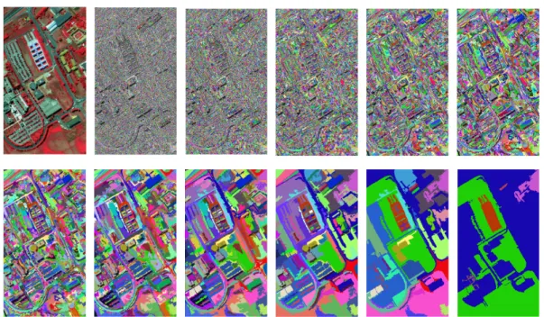
Figure 1.3: An illustration of multiscale segmentation on hyperspectral image captured at Pavia University. Original false color image is shown at beginning (top left), followed by 11 differ-ent segmdiffer-entation maps generated using Hseg with dissimilarity criterion set respectively as α = [0.5, 1, 2, 4, 8, 16, 32, 64, 128, 256, 512].
Rb= 1
Area(R)
∑
Pixeli∈R
Pixelib, (1.1)
where Rbis the spectral band b of region R and its average Rb, Area(R)is the size of the region and Pixeliis one pixel in the region R with its spectral information of band b written as Pixelb
i.
As far as the merging criterion is concerned, “Band Sum Mean Squared Error (MSE)” is used for evaluating the dissimilarity of one region versus another. It is defined as:
MSE(Ri, Rj) = Area(Ri)Area(Rj) Area(Ri) +Area(Rj) B
∑
b=1 (Rb i −Rbj)2. (1.2)Such a dissimilarity measures the distance between two regions, and is used to deter-mine the merging order at each iteration step. Relying on the predefined dissimilarity crite-rion, Hseg can output multiscale segmentation maps, forming a partitioning tree in arbitrary form. Fig. 1.3 shows an example on multiscale segmentation maps using Hseg for hyper-spectral remote sensing image, where the dissimilarity criterion α =qMSE(Ri, Rj)is set as
1.2 – Hierarchical image representations and applications 11
1.2.3 Applications in remote sensing
Spatial-spectral classification
Spatial-spectral classification, which incorporates spatial information to improve the sification results, has became one of the most popular approaches for remote sensing clas-sification [62, 76, 157, 25], especially when the image spatial resolution is high. In these approaches, spatial information is extracted at the image region level rather than at the con-ventional pixel level.
Therefore, one of the key application of hierarchical representation is the modeling of the context of a pixel. Through the hierarchy, the context models the evolution of a pixel and describes it at different scales [55, 25]. One of the most popular examples is attribute profiles, relying on Max- and Min- tree [48], or Tree of Shapes [30].
The Attribute Profile built on the image I can be written as:
AP(I) = {φλL(I), φλL−1(I), . . . , φλ1(I), I, γλ1(I), . . . , γλL−1(I), γλL(I)}, (1.3)
where the φ and γ stands for the thickening and thinning operator respectively, λL is the
scale parameter at the level L. In such a setting, each pixel in the image can be represented as its corresponding values in AP(I), a stacked vector of dimension 2L+1.
In addition to attribute profiles, other techniques have also been proposed to model con-textual information with hierarchical representations. In [25], the authors state that given a hierarchical image representation, it is possible to exploit the relationships between pixels and regions at different levels to extract an effective set of features that describes each pixel and its adaptive context at each level. In [113], a similar multiscale context feature extraction strategy is proposed, but with a different hierarchical image representation called α-tree.
All the previous methods discussed so far share similar strategy when using the multi-scale features. Once extracted, these features are concatenated into a long raw (i.e. flat, un-structured) vector, on which is applied a conventional vector-based machine learning tech-nique (e.g. SVM with the Gaussian kernel). Such stacked vectors are usually sets of highly dimensional features. Consequently, as mentioned in [76], they should be properly handled in order to make full exploitation of the discriminative information, and avoid issues raised by very large dimensionality (Hughes phenomenon) and high redundancy [152].
Spatial pyramid matching model
The Spatial Pyramid Matching (SPM) model [109, 209] is the most common strategy to con-sider the object spatial decomposition based on a hierarchical representation. The idea is to segment the image in 4 regions at successive scales (through a quad-tree representation), and
to concatenate all the region features into a long vector. With such a hierarchical represen-tation, objects and their subparts can be revealed in various scales, and the relative spatial arrangement of the objects and the object decomposition information can be also modeled. These features play a significant role in classification of complex patterns [214].
However, the matching strategy of SPM limits its application to quad-tree representa-tions, preventing it to benefit from advanced multiscale segmentation techniques that lead to meaningful but mostly irregular hierarchical representation. In addition, SPM only al-lows matching image regions at the same spatial position. Therefore, applying SPM to re-mote sensing image classification is not optimal since SPM hardly adapts to images with no predefined location or orientation [221, 35, 213].
GEOBIA
GEOgraphic-Object-Based Image Analysis (GEOBIA) framework has gained increasing in-terest and is today a paradigm for remote sensing image processing [16, 17] beyond conven-tional pixel-based analysis. In this framework, hierarchical image representation is the key concept — meaningful objects are obtained from multiscale image segmentation, and spatial relationships among objects are encoded in a tree structure.
The main trends of GEOBIA have shifted from choosing the correct scale for analyz-ing objects [56], recognizanalyz-ing the different changes occurranalyz-ing at different scale for different type of objects [83], and also understanding the mutual relations between image objects [17]. Within the hierarchical representation, each object is characterized not only by segment-related characteristics, which are its spectral, shape or texture features, but also with the topological information (e.g. A is part of B, or B consists of A). In addition, semantic rela-tionships between objects at different levels revealed from hierarchical representation allow effective multiscales analysis. For instance, building and tree species at finer level can form residential blocks at intermediary level, and groups of residential blocks can form urban area at coarse scale.
The first commercial object-based image analysis software is eCognition and triggered the major trend of object-based remote sensing image analysis. Most applications have em-ployed this software with a rule set based classification framework. In [36], hierarchical rule-sets have been designed to incorporate the expert knowledge, e.g. thresholding the NDVI information is used for distinguish vegetation and non-vegetation, and height information, ratio of width and length of object, are further included to divide the non-vegetation into building, vacant land, and road. A similar rule-set based scheme can be found in [170] for mapping gully extraction using high spatial resolution imagery. In [121], the authors pro-pose to rely on the object features and the spatial relations between objects to extract roads and moving vehicles from remote sensing imagery. Object features such as size, shape can
1.3 – Kernel-based machine learning 13
differentiate road and vehicle, and spatial relations between objects, i.e. moving vehicles are surrounded by a road, help to refine classification results and extract particularly moving vehicles.
The knowledge-based subjective rule-set strategy commonly used in GEOBIA is highly relying on human involvement and interpretation, which makes it difficult to adapt to new locations and datasets, and makes the processing of data in large remote sensing archives practically impossible. Advanced machine learning techniques are thus required for learn-ing automatically properties of the objects and the relationships among them.
1.3
Kernel-based machine learning
1.3.1 Kernel definition
Kernels are popular in machine learning, thanks to their capability of capturing non-linear patterns in the data. They have been introduced to map data in a new feature space, where it becomes possible to separate linearly the transformed data.
Following the kernel definition in [166], let us define a kernel as a function k(·)that for
x, x0 ∈ X satisfies:
k(x, x0) = hφ(x), φ(x0) iH,
φ: x∈ X 7−→φ(x) ∈ F ,
(1.4)
where φ is a mapping from the original input spaceX to a feature spaceF, and the inner
product of two mappinghφ(x), φ(x0)iHcan be directly computed using kernel function on
their original space k(x, x0).
A well known example is the polynomial kernel. Let x= [x1, x2] ∈R2a two dimensional vector, and the mapping function is defined as φ : x 7−→ φ(x) = [x21, x22,
√
2x1x2] ∈ R3. Fig. 1.5 shows an example of such a mapping, non-linearly separable data in original space
R2can become linearly separable in the feature spaceR3.
Further, we can compute the inner product between the projections of data without ex-plicitly evaluating them in the feature space. Following the previous example, we have
k(x, x0) =<φ(x), φ(x0) > = [x21, x22,√2x1x2]T [x021, x0 2 2, √ 2x10x02] = x21x021+x22x022+2x1x2x10x02 = (x1x01+x2x02)2= (xTx0)2 (1.5)
(a) Decision boundary with linear SVM (b) Decision boundary with kernel SVM
Figure 1.4: Illustration of non linear separable case with linear SVM and kernel SVM.
(a) Data in the input spacex∈R2 (b) Data in the feature space φ(x) ∈R3 Figure 1.5: Illustration of data in the original input space and feature space.
where the kernel function k(x, x0) = (xTx0)2 can be computed directly in the original data input space. This is known as the “kernel trick” and it is very helpful since the high dimensional feature space does not need to be projected firstly. In other cases, φ(·)might be unknown, such as with the Gaussian kernel.
1.3.2 A kernel method example: Support Vector Machine (SVM)
We briefly introduce SVM in this section, interested readers are referred to [67] for a detailed description.
Linear SVM
Let us assume a binary classification problem that consists of N pairs
1.3 – Kernel-based machine learning 15
of SVM is defined as f(x) = xTβ+β0such that if f(xi) < 0, yi = −1 , yi = 1 otherwise. In short, we have yif(xi) ≥ 0, where β, β0are the parameters of the model and need to be learned.
In order to learn the parameters β, β0, SVM minimizes the following objective function
kβk2+C
N
∑
i=1max(0, 1−yif(xi)) (1.6)
where kβk2 is the L2 regularization on the parameters of the model, and the function
max(0, 1−yif(xi))is the hinge loss function. C is a hyper-parameter that controls the bal-ance between the loss (how well the model fits on training data) and the regularization (the complexity of the model).
The geometric interpretation of SVM can be seen as the margin maximization problem,
where the decision boundary is defined as a hyperplane xTβ+β
0 = 0, and the distance
from the decision surface to the closest data point is called margin and is defined as k2βk, as shown in Fig. 1.6. While maximizing the margin, SVM can be rephrased into a constrained optimization problem: min β kβk s.t. yi(xTi β+β0) ≥1−ξi ξi ≥0;
∑
ξi ≤Constant (1.7)where ξi is called slack variable that allows the violation of the margin at the non-negative cost of ξi. The sum of all costs ξiis bounded by a constant, which limits the total number of predictions on the wrong side of its margin.
One might notice that the optimization problem of Eq. (1.6) and Eq. (1.7) leads to the same solution, and they can be further rewritten in an equivalent form, often called primal form: min β 1 2 kβk 2+C
∑
N i=1 ξi s.t. yi(xiTβ+β0) ≥1−ξi; ξi ≥0 (1.8)The above constrained optimization problem can be rewritten in its dual form (see [67] for detailed derivation):
max α N
∑
i=1 αi− 1 2 N∑
i=1 N∑
i0=1 αiαi0yiy i0xiTxi0 s.t. 0≤αi ≤ C; N∑
i=1 αiyi =0 (1.9)The decision function derived from dual formulation can be written as:
f(x) =
N
∑
i=1αiyi(xiTx) +β0 (1.10)
Figure 1.6: The geometric interpretation of a linear SVM.
Non-linear SVM with kernel
The SVM described so far allows finding linear boundaries in the input space. However, we can make the procedure more flexible by enlarging the original input space. The
representa-tion in feature space is obtained by the applicarepresenta-tion of an appropriate funcrepresenta-tion φ : x∈ X 7−→
φ(x) ∈ F. Consequently, we work with the samples:(φ(x1), y1),(φ(x2), y2)...,(φ(xN), yN) ∈
F × Y.
We can represent the optimization problem (primal form) as following:
min β 1 2 kβk 2+C
∑
N i=1 ξi s.t. yi(φ(xi)Tβ+β0) ≥1−ξi; ξi ≥0 (1.11)1.3 – Kernel-based machine learning 17 max α N
∑
i=1 αi− 1 2 N∑
i=1 N∑
i0=1 αiαi0yiy i0hφ(xi)Tφ(xi0)iH s.t. 0≤ αi ≤ C; N∑
i=1 αiyi =0 (1.12)The optimization solution α requires the computation ofhφ(xi)Tφ(xi0)iHfor each pair of data in the set. One can use the kernel function k(x, x0) = hφ(x), φ(x0)iH to compute the
inner product in feature space F directly from input spaceX. One example of such “trick” is
given in Eq. (1.5).
By solving the dual optimization problem, one obtains the nonlinear decision function
f(x) =
N
∑
i=1αiyihφ(xi), φ(x)i +β0, (1.13)
and in kernel function form, one obtains
f(x) =
N
∑
i=1yiαik(xi, x) +β0. (1.14)
Using kernel allows avoiding the computation of mapping φ(x)and the inner product
in higher dimension space. In addition, the mapping function φ(x) is not always known
e.g. Gaussian kernel, and the kernel trick allows one to compute implicitly the inner product without knowing the mapping function.
1.3.3 Large-scale learning for kernel methods
The kernel trick can compute implicitly the inner product in the feature space without map-ping the data, which has been successful applied in a large range of problems from different domains. However it shows some limitations in the context of large-scale machine learning: methods operating on kernel matrix can hardly scale up w.r.t. training sample size, because of the calculation of kernel matrix (at least quadratic w.r.t. training sample size as shown in Eq. 1.12). This prevents them to be applied on large-scale learning problems [160].
Recently, techniques for kernel value approximation have been well investigated in the context of accelerating the training time in kernel methods [212], e.g., the Nyström method and the Random Fourier features (RFF) technique. The Nyström method approximates the full kernel matrix by a low rank matrix computed with a subset of training examples, while the RFF technique [160, 161] is a data-independent method which is widely applied due to its efficient computation and approximation quality. The rational is to approximate the kernel by explicitly mapping the data (with basis functions as cosine and sine) into a low
dimensional Euclidean space, in which the inner product of the explicit features vector ap-proximates the kernel value.
The advantages of RFF come with the fact that linear machine learning methods can be directly applied on the resulting vectors. While non-linear SVM using kernel yields a quadratic complexity w.r.t. training samples, linear SVM with efficient solver can reduce the complexity to linear. By adopting such a strategy, the empirical study in [125] shows the capability of training on large-scale image recognition problems.
1.3.4 Structured kernel
Nowadays, data are represented in a structured form in many real-world applications such as natural language processing [219], bioinformatics [128], chemoinformatics [81], XML trees in web mining [39, 41] and image processing [87]. Among the popular solutions to process such data are kernel methods, e.g. Support Vector Machine (SVM) [166]. Applying SVM on structured data requires either to vectorize the input data, or to define structured kernels. The latter option is to be preferred to benefit from the rich structure brought by strings, trees, or graphs.
For learning on structured data, various kernels have been proposed, which includes optimal assignment kernel [68, 105], alignment kernel [47], match kernel [19] and others [71]. However, the most standard way to construct a structured kernel is to follow the convolution kernel framework [88]. According to this framework, a kernel on a complex structure can be formed by tailoring simple kernels computed on its substructures.
Following the definition of the convolution kernel in [88, 169], let us define x ∈ X as a
complex structure and x0as the parts of x by a relation R on the setX0× X, where R(x0, x)is true if and only if x0are the parts of x. Given such a relation, we can define the decomposition R−1 = {x0 : R(x0, x)}. Suppose we have a kernel k onX0that measures the similarity k(x0, y0)
between the part x0and the part y0(note that x0 and y0are often called substructures that can be extracted from complex structures x and y respectively). Then the convolution kernel is defined as:
K(x, y) =
∑
{x0}∈R−1(x){y0}∈
∑
R−1(y)k(x0, y0), (1.15)
where if the kernel k :X0× X0 → R is a positive semidefinite kernel, K :X × X →R is
also positive semidefinite.
Following such a definition, the key idea is to define the appropriate substructures that can decompose the complex structure. However, there is no universal substructure for struc-tured data, and the available options are numerous (see [168] for the case of trees). The se-lection of the appropriate substructure thus depends on the kind of data and application
1.4 – Conclusion and organization of the manuscript 19
that are considered. To drive this selection, one can keep in mind that according to [98], a “good” kernel depends on both its effectiveness and expressiveness power. The former refers to how good a substructure can represent the whole structure, while the later refers to the computational complexity required when calculating such a kernel. Most often the appropriate kernel is the result of a trade-off between expressiveness and effectiveness. If the substructure is too simple, the kernel might not be able to capture the characteristics of the underlying data. Conversely, complicated substructures might lead to intractable kernel computation schemes.
Nevertheless, the capabilities of taking directly into account structured data have mo-tivated various attempts to define new kernels, e.g. in bioinformatics [131], physics [63], language processing [175], or even image analysis. Indeed, many solutions have been intro-duced recently to perform machine learning on graph-based image representations [8, 87, 200, 65, 177, 179, 57]. Such representations are usually based on region-adjacency graphs that are built from a prior segmentation of the input image, where the vertices of the graph encode the regions while the edges encode the relations between neighboring regions [8, 87, 200].
Inspired by the literature in kernel design for various types of structures, especially for graph-based image representation, we explore in this thesis how to design a structured ker-nel that make possible learning from hierarchical image representations.
1.4
Conclusion and organization of the manuscript
1.4.1 Motivations and contributions
In this chapter, we first briefly reviewed the trends in remote sensing image classification in Sec. 1.1, where one may notice that including the spatial information is one of the key con-cepts for improving classification accuracy. It can help increasing smoothness for pixel-wise classification, and providing crucial patterns for tile classification. One way to reveal spatial information relies on hierarchical image representations, where objects-of-interest can be re-vealed at various scales and topological relationships among them are modeled through the hierarchy. Indeed, such representations have been adopted with various applications in the remote sensing community, as reviewed in Sec. 1.2.
This thesis aims to link machine learning techniques and hierarchical image representa-tions. Our goal is to take into account spatial information presented in an image through a hierarchical organization of objects. Such a hierarchy of objects can be represented with a tree structure, where the nodes represent the objects-of-interest and edges model the hierar-chical relationships among them. Our objective is to exploit machine learning techniques to take into account these specific representations of data and discover the meaningful patterns
that can lead to good classification results.
In the literature, one of the most standard ways to learn on structured data is to design a structured kernel. It can directly take the structures as input and benefit from various suc-cessful kernel-based machine learning methods. Such a scheme is especially well-adopted in the domain of bioinformatics, natural language processing and chemistry, where the data to be handled are often coming in a structured form. In addition, the kernel methods, espe-cially SVM, have been well established in remote sensing [27]. These various aspects motive us for exploring kernel-based learning on hierarchical image representations.
In addition, we often face a large amount of data in the remote sensing community. Meanwhile, advanced techniques such as RFF enable us to apply kernel methods in a large-scale context. This motivate us to develop scalable methods to enable the application of proposed kernels to remote sensing image classification.
We introduce in this thesis a structured kernel called (S)BoSK (Bag of Subpath Kernel and its Scalable version) for capturing the hierarchical relationships between nodes of a tree. It can be viewed as an instance of the convolution kernel relying on the extraction of subpath substructures. The main applications focus on remote sensing image classification: (S)BoSK operates on paths, thus allowing modeling the context of a pixel (leaf of the hierarchical representation) through its ancestor regions at multiple scales; (S)BoSK also works on trees, that makes the kernel able to capture the composition of an object (top of the hierarchical representation) and the topological relationships among its subparts; relying on (S)BoSK, we also introduce a novel multi-source classification approach that performs classification directly from a hierarchical image representation built from two images of the same scene taken at different resolutions, possibly with different modalities.
1.4.2 Organization
The rest of the thesis is organized as follows:
• Chapter 2 starts introducing the main contributions of this thesis from a methodologi-cal point of view. We present a structured kernel methodologi-called Bag of Subpaths kernel (BoSK) for data with an unordered tree or path structure, and equipped with numerical fea-tures. Both exact computation based on iterative scheme and approximated computa-tion based on Random Fourier Features are provided in different contexts: while BoSK can be efficiently computed for small structures and small training data size, its scal-able version SBoSK is more suitscal-able to large-scale learning context with a large number of available training samples or/and large structures.
• Chapter 3 presents the first application of (S)BoSK on the path structure for pixel-wise image classification. The path structure represents the spatial context of a pixel in the
1.4 – Conclusion and organization of the manuscript 21
hierarchical representations, where the nodes in each path start from the pixel and continue with its ancestral regions at multiple scales from fine to coarse. Relying on such a structure, (S)BoSK can take into account the contextual information for each pixel by exploiting the regions from different scales and the hierarchical relationships among them. Evaluations on different datasets indicate the superiority of (S)BoSK over other spatial spectral pixel-wise classification techniques.
• Chapter 4 introduces the second application of (S)BoSK on the tree structure for sub-image/tile classification. The root of a tree structure is the tile and rest of the nodes are the subregions at multiple scales organized hierarchically. Assessing inputs as tree structures, (S)BoSK allows considering spatial decomposition of a tile through its sub-regions and relationships among them. Evaluations on different datasets show that (S)BoSK can surpass other state-of-the-art decomposition-based techniques.
• Chapter 5 presents a novel multi-source and multi-resolution image classification method that combines (through a hierarchical representation) two images taken from different resolutions and sensors over the same area. The coarser levels of the hierar-chy built from the lower resolution image can reveal contextual information, while the finer levels are constructed from the higher resolution image and are used to model the spatial decomposition. Two (S)BoSK are then employed to perform machine learn-ing directly on the constructed hierarchical representation, aimlearn-ing at combinlearn-ing both contextual and decomposition information into a unique classification scheme.
• Chapter 6 provides some conclusions from the work presented herein, along with con-sidered improvements closely related to the proposed methods, as well as some per-spectives on future research directions.
1.4.3 List of publications
The following publications are based on the research presented in this thesis:
1. Yanwei Cui, Laetitia Chapel, and Sébastien Lefèvre. “A subpath kernel for learning hierarchical image representations”. In: International Workshop on Graph-Based
Repre-sentations in Pattern Recognition. 2015, pp. 34–43. DOI:10.1007/978-3-319-18224-7_4
2. Yanwei Cui, Laetitia Chapel, and Sébastien Lefèvre. “Combining multiscale features for classification of hyperspectral images: a sequence based kernel approach”. In: In-ternational Workshop on Hyperspectral Image and Signal Processing: Evolution in Remote Sensing. 2016. URL:http://arxiv.org/abs/1606.04985
3. Yanwei Cui, Sébastien Lefèvre, Laetitia Chapel, and Anne Puissant. “Combining mul-tiple resolutions into hierarchical representations for kernel-based image classifica-tion”. In: International Conference on Geographic Object-Based Image Analysis. University
of Twente, Enschede, The Netherlands, 2016. DOI:10.3990/2.372
4. Yanwei Cui, Laetitia Chapel, and Sébastien Lefèvre. “Scalable bag of subpaths kernel for learning on hierarchical image representations and multi-source remote sensing data classification”. In: Remote Sensing, Special Issue Advances in Object-Based Image
Analysis—Linking with Computer Vision and Machine Learning 9.3 (2017). DOI: 10.3390/
23
Chapter
2
Scalable Bag of Subpaths Kernel
(SBoSK) for numerical features
Contents
2.1 Introduction . . . 24 2.2 Related work . . . 25 2.3 Bag of Subpaths Kernel . . . 29 2.4 Scalable Bag of Subpaths Kernel . . . 33 2.5 Conclusion . . . 39
In the previous chapter, we have presented why learning on hierarchical image represen-tations was an open challenge that we address in this thesis.
This chapter describes our main contributions from a methodological point of view. We present a structured kernel dedicated to unordered trees with numerical features. This chap-ter concentrates on presenting the mathematical details of the proposed kernel. Its applica-tions to machine learning on hierarchical image representaapplica-tions are further detailed in the following chapters.
2.1
Introduction
Data are often represented in a structured form in many real-world applications. The struc-ture helps encoding the internal relations among elements. For instance, an XML tree en-codes the hierarchical relationships among different elements presented in a document. A molecule can be analyzed as a graph structure that represents the structural formula of atoms. In image processing, it is popular to describe the content of an image through struc-tured data, where image regions are presented in a set, and are organized through structures linking different regions together. Successful examples of such representations are region adjacency graph [87], or tree structures [17].
In the context of machine learning, conventional techniques often require the data to be in a vector form. In order to learn on structured data, one popular strategy consists in design-ing meandesign-ingful structured kernels (i.e. kernels built on structured data), and feed them into kernel-based machine learning methods such as SVM. Such kernels have been successfully applied in various domains as they are capable to extract discriminative features directly from the structures. Among popular approaches for designing kernels, the most standard way to construct a structured kernel is to follow the convolution kernel framework [88]. Ac-cording to this framework, computing a kernel on a complex structure can be achieved by summing up the kernels built on its substructures. In the literature, various substructures have been used (see [168] for the case of trees) and the selection of the appropriate substruc-ture depends on the kind of data and application that are considered.
In our context i.e. designing a kernel that can learn on hierarchical image representations, several critical aspects have to be taken into account.The importance of these aspects will be illustrated in the following chapters with concrete examples.
• Unordered tree: we concentrate on kernels that can handle unordered trees (through which hierarchical image representations are often modeled). Such kernels should be able to capture the hierarchical relationships (i.e. parent-children relation) among the nodes.
• Numerical features: another important property in hierarchical image representations is that each node represents a region, and that attributes of a region, e.g. color or size, are in general numerical features. This actually differs from many other domains where nodes are labeled by a fixed number of symbols.
• Robustness to structure distortion and noise: hierarchical representations heavily rely on the adopted construction techniques. These techniques build the tree in an unsu-pervised way, which tree structure might vary due to complexity of image contents, presence of the noise, or undesired regions grouped together. Thus the resulting
struc-2.2 – Related work 25
tures are less strict than the one in other domains such as chemoinformatics. This should be taken into account when designing the kernel.
• Complexity: the adopted kernel should be efficient and scalable. Unlike other do-mains, such as chemoinformatics, or nature language processing, where the data struc-tures are relatively small, hierarchical representations often have a large number of nodes, and attribute of each node might be up to thousands of dimension. In addi-tion, some image classification problems in literature might possess a large number of available training samples, complexity issues are then critical.
To address all the aspects mentioned above, we propose a structured kernel based on the concept of subpath. It works on vertical hierarchical relationships among nodes in the structured data, with nodes equipped with numerical features.
For its computation, we propose an iterative approach with a quadratic complexity w.r.t. the size (i.e. number of nodes) of structured data, and a quadratic complexity w.r.t. number of training samples. It is efficient when dealing with small structure size and limited number of training samples, and we call it BoSK (for Bag of Subpaths Kernel).
In addition, when running on large-scale datasets, we propose to compute the kernel ap-proximately by explicit mapping the kernel into randomized low dimensional feature spaces using Random Fourier Features. This approximation yields a linear complexity w.r.t. size of structured data, and a linear complexity w.r.t. number of training samples. Therefore, the resulting approximation scheme makes the kernel applicable for large-scale real world prob-lems. We call it Scalable Bag of Subpaths Kernel (SBoSK).
The chapter is organized as follows: we give a brief review in Sec. 2.2 on learning on structured data, with a particular focus on convolution kernels and large-scale structured kernels. Then we introduce BoSK in Sec. 2.3, with its scalable version SBoSK in Sec. 2.4. In the end, we summarize the chapter in Sec. 2.5.
2.2
Related work
2.2.1 Learning on structured data
Various approaches have been proposed in order to perform machine learning on structured data. In this section, we give a brief review of different directions that can be found in the literature.
Defining distance measures has already existed for a long time for learning on structured data [182, 163, 69, 187]. Among various distances, the edit distance is considered as one of the most well established frameworks in pattern recognition and classification [14, 69]. It
![Figure 3.15: Hierarchical segmentation maps of Strasbourg Spot-4 dataset. All levels of segmentation are illustrated here by using dissimilarity criterion α = [ 2 − 2 , 2 − 1 , 2 0 , 2 1 , 2 2 , 2 3 , 2 4 ] .](https://thumb-eu.123doks.com/thumbv2/123doknet/11573716.297699/70.892.148.760.308.929/figure-hierarchical-segmentation-strasbourg-segmentation-illustrated-dissimilarity-criterion.webp)