VARIABILITÉ SAISONNIÈRE ET INTERANNUELLE DES EAUX DOUCES DANS LES MERS ARCTIQUES: LE CAS DE LA BAIE D'HUDSON
THÈSE PRÉSENTÉE
À
UUNIVERSITÉ DU QUÉBEC À RIMOUSKI comme exigence partielle
du programme de doctorat en océanographie
PAR
PIERRE ST-LAURENT
Avertissement
La diffusion de ce mémoire ou de cette thèse se fait dans le respect des droits de son
auteur, qui a signé le formulaire « Autorisation de reproduire et de diffuser un rapport,
un mémoire ou une thèse ». En signant ce formulaire, l’auteur concède à l’Université du
Québec à Rimouski une licence non exclusive d’utilisation et de publication de la totalité
ou d’une partie importante de son travail de recherche pour des fins pédagogiques et non
commerciales. Plus précisément, l’auteur autorise l’Université du Québec à Rimouski à
reproduire, diffuser, prêter, distribuer ou vendre des copies de son travail de recherche à
des fins non commerciales sur quelque support que ce soit, y compris l’Internet. Cette
licence et cette autorisation n’entraînent pas une renonciation de la part de l’auteur à ses
droits moraux ni à ses droits de propriété intellectuelle. Sauf entente contraire, l’auteur
conserve la liberté de diffuser et de commercialiser ou non ce travail dont il possède un
exemplaire.
l would like to thank the members of my thesis committee and jury, Dr. M. Gosselin (chair, ISMER-UQAR), Dr. SJ. Déry (examiner on jury, UNBC), Dr. K.F. Drinkwater (examiner on committee, IMR) , and my thesis supervisors, Dr. F. Straneo (advisor, WHOI), Dr. J. -F. Dumais (co-advisor, ISMER-UQAR), and Dr. D.G. Barber (co-advisor, Univ. Manitoba). They provided precious insight into the scientific questions examined, and the thesis highly benefited from their constructive and helpful comments. Dr. Straneo in particular was a dedicated and enthusiastic advisor, and it was a joy to work with her over the last two years.
The Dr. F.J. Saucier was the instigator and first advisor of this research project. His contagious passion for science, as weIl as the exuberant spirit he exhibited whenever l came up with novel results and ideas on Hudson Bay, were a constant inspiration and motivation over the first year of the project. l can hardly express how sorry l was to see him leave the institute, and ultimately lose his fight against cancer. The thesis is dedicated to his memory.
Plusieurs personnes m'ont aidé et supporté dans mon travail au fil des dernières années: tout d'abord Simon Senneville, par sa compréhension profonde du modèle de François, son souci pour la réussite des étudiants, et sa bonne humeur contagieuse; James Caveen, qui partage mon goût pour les systèmes d'exploitation dignes de ce nom et les écrans noirs avec de gros caractères blancs; Marcelle Martin et l'équipe de la bibliothèque de l'UQAR, qui ont poussé leurs recherches jusqu'en Australie pour obtenir les livres dont j'avais besoin; le personnel de soutien de l' ISMER, qui ont tout fait pour m'accommoder dans mes requêtes ...
... et tous mes collègues et amis du laboratoire et de l'UQAR en général! « If 1 never meet you in this fife, let me feel the lack », écrivait James Jones. Ça a été un plaisir de vous côtoyer, et je ne vous oublierai pas de sitôt.
1 The Arctic seas are characterized by the presence of a sea ice cover, a large river input and a net precipitation rate that make them fresh relative to the rest of the ocean, and a net export of freshwater via Fram Strait and the Canadian Arctic Archipelago. Recent studies highlight the substantial variability in the freshwater content of these seas and in their freshwater export to the nordic and subarctic seas. The goal of this work is to better understand the controls and impacts of the variability in Arctic sea's freshwaters. The thesis specifically focuses upon Hudson Bay, a large and shallow basin characterized by low salinity waters, a seasonal ice cover, and a large seasonal river input. The body of the thesis has three chapters whose objective, method, and main results, are summarized in the following lines.
The objective of the first chapter is to examine the impacts of the seasonal ice cover upon the ocean ftow. The study specifically focuses on what effect the friction against the sea ice cover has on the barotropic tidal currents. The analysis makes use of new observations collected from eight different moorings successfully deployed over one complete seasonal cycle or longer. The instrument records reveal significant seasonal variations in Foxe Basin, Hudson Strait, and Hudson Bay. Multi-year records confirm the recurrent nature of this variability, and numerical simulations with a 3-D sea ice-ocean coupled model confirm the definite role played by friction in this variability. Regions of the basin where the ftow is most affected are identified. The chapter was published in the Journal of Geophysical Research.
The objective of the second chapter is to investigate the processes controlling the fate of the river waters of Hudson Bay. To circumvent the lack of year-round surveys of these waters, the study makes use of a highly realistic 3-D sea ice-ocean coupled model whose results are consistent with the available observations. Most of the river waters are found to be transported by the general cyclonic circulation although a significant fraction is diverted to the interior of the basin. Ekman dynamics control the seasonal cross-shore exchange of river waters, with a variability that follows the curI of the wind stress over the basin. A tracer experiment confirms that a significant volume of river water is stored in the interior. Thus, this area can act as a reservoir that can substantially modulate the amount of freshwater released downstream to the subarctic seas. The chapter has been submitted to the Journal of Marine Systems.
The objective of the third chapter is to examine what controls the interannual variability in the storage and export of freshwater. A conceptual model of an Arctic sea is designed and applied to the case of Hudson Bay. Following the results from previous chapters and other studies, the model makes use of highly realistic forcing for the rivers and winds. A 1 Notez que les sections Résumé, Introduction Générale, et Conclusion Générale, sont présentées en anglais et en français dans la thèse. Dans toutes ces sections la version anglaise précède celle en français, le passage d'une langue à l'autre étant souligné par le symbôle ...
hindcast simulation is conducted over the past 28 years and it shows substantial interannual variability in both storage and export of freshwater. In agreement with recent observations from the Beaufort Sea, the storage is controlled by Ekman pumping events, and its long-term evolution is related to the large-scale variability of the atmosphere (the Arctic Oscillation). The model results are compared to historical and previously unpublished observations, and the simulation is found consistent with the data. The chapter will soon be submitted to a peer-reviewed journal.
Les mers arctiques sont caractérisées par la présence d'une couverture de glace, un grand apport des rivières et un bilan précipitation-évaporation positif qui les rendent peu salées par rapport au reste des océans, et enfin, un net export d'eau douce via le détroit de Fram et via l'Archipel arctique canadien. Des études récentes mettent en lumière la variabilité substantielle dans le contenu en eau douce de ces mers et dans leur export d'eau douce vers les mers nordiques et subarctiques. Le but de ce travail est de mieux comprendre les impacts de cette variabilité et les processus qui la contrôle. La thèse se concentre sur la baie d'Hudson, un grand bassin peu profond caractérisé par des eaux peu salées, une couverture glacielle saisonnière, et un grand apport saisonnier des rivières. Le corps de la thèse comporte trois chapitres dont les objectifs, méthode, et principaux résultats, sont soulignés dans les lignes suivantes.
L'objectif du premier chapitre est d'examiner les impacts de la couverture glacielle saisonnière sur l'écoulement océanique. L'étude se concentre plus spécifiquement sur l'effet de la friction à l'interface glace-océan sur les courants de marée barotropes. L'analyse fait usage de nouvelles observations provenant de huit différents mouillages déployés avec succès durant un cycle saisonnier complet ou plus. Les relevés des instruments révèlent des varia-tions saisonnières significatives dans le bassin de Foxe, le détroit d'Hudson, et la baie d'Hud-son. Des séries temporelles pluriannuelles confirment la nature récurrente de cette variabilité saisonnière, et les simulations numériques d'un modèle 3-D océail-glace de mer confirment le rôle important joué par la friction océan-glace dans cette variabilité. Les régions du bassin où l'écoulement est le plus affecté sont identifiées. Le chapitre a été publié dans le Journal of Geophysical Research.
L'objectif du second chapitre est d'examiner les processus contrôlant le devenir des eaux des rivières de la baie d'Hudson. Étant donné le peu de mesure disponibles hors de la courte période libre de glace, l'étude fait usage d'un modèle 3-D couplé océan-glace de mer réaliste dont les résultats sont cohérents avec les observations disponibles. Alors que la majeure partie des eaux des rivières est transportée par la circulation générale cyclonique, une proportion significative est détournée vers l'intérieur du bassin. La dynamique d'Ekman contrôle cet échange saisonnier des eaux des rivières entre la zone côtière et l'intérieur, en
suivant la variabilité du rotationnel des contraintes appliquées à la surface de l'eau. Une expérience avec un traceur numérique confirme qu'un volume important d'eau des rivières est stocké dans l'intérieur, cette région pouvant agir tel un réservoir qui peut moduler de façon substantielle l'ex port d'eau douce vers les mers subarctiques situées en aval. Ce chapitre a été soumis au Journal of Marine Systems.
L'objectif du troisième chapitre est d'examiner les processus contrôlant la variabilité interannuelle du stockage et de l'export de l'eau douce. Un modèle conceptuel d'une mer arctique est développé et appliqué au cas de la baie d'Hudson. Le modèle fait notamment usage de forçages hautement réalistes pour les rivières et les vents. Une simulation des 28 dernières années montre une variabilité interannuelle substantielle pour le stockage et l' export de l'eau douce. En accord avec de récentes observations de la mer de Beaufort, le stockage est contrôlé par les événements de pompage d'Ekman, et son évolution à long-terme est mise en relation avec la variabilité atmosphérique de grande-échelle (l'oscillation arctique). Les résultats du modèle sont comparés avec des observations historiques et d'autres présentées pour la première fois. De façon générale la simulation est cohérente avec ces observations. Le chapitre sera bientôt soumis à un journal revu par les pairs.
REMERCIEMENTS RÉSUMÉ ... . TABLE DES MATIÈRES . LISTE DES TABLEAUX . LISTE DES FIGURES . . INTRODUCTION GÉNÉRALE ARTICLEI
ON THE MODIFICATION OF TIDES IN A SEASONALLY ICE-COVERED SEA . 1.1 Abstract. .
1.2 Introduction 1.3 Method ...
1.3.1 Observations
1.3.2 Numerical Simulations 1.4 Results from Observations . .
1.5 Results from Numerical Experiments .
111 v ix xii xiii 1 23 23 24
27
27
30 34 391.5.1 Comparison with Observations. 39
1.5.2 The Role of the lee-Ocean Friction in the Modification of Tides 40 1.5.3 Local and Remote Effects ofthe lee-Ocean Stress upon Tides 41 1.5.4 The Effects of the Tides upon the lee Cover 43 1.6 Discussion.
1.7 Conclusions 1.8 Acknowledgements ARTICLE II
WHAT IS THE FATE OF THE RIVER WATERS OF HUDSON BAY? . 2.1 Abstract. . 2.2 Introduction 2.3 Method .. 45 47 47 49 49 50 54
2.4 Results .. . ... .... .. ... 2.4.1 The Baseline: the Annuai Freshwater Budget 2.4.2 The Role of Sea !ce Growth and Melt 2.4.3 The Fate of the River Waters . . . . .
2.4.4 Exchanges between the Boundary and Interior Regions 2.4.5 What Regulates the Freshwater Stored in the Interior? 2.4.6 The Residence Time of the River Waters.
2.5 Discussion . 2.6 Conclusions 2.7 Acknowledgements ARTICLE III
STORAGE AND EXPORT OF FRESHWATER IN ARC TIC SEAS: THE CASE OF HUDSON BAY 3.1 3.2 3.3 3.4 Abstract .. Introduction Method . .
3.3.1 The Conceptuai Modei
3.3.2 Forcing used in the Simulations Results . ... .. ...
3.4.1 General Features from the Model Simulation and Comparison with Observations . . . . . . . . .
3.4.2 Storage and Export of Freshwater in Hudson Bay 3.4.3 The Formation of the Fresh Bursts . . ... .
3.4.4 Is the Freshwater Balance in Phase with Climatic Indices? 3.5 Discussion . 3.6 Conclusions 3.7 Acknowledgements CONCLUSION GÉNÉRALE . RÉFÉRENCES . . .. ... . 59 59 61 62 66 67 73 77 79 80 81 81 82 84 84 85 91 91 96 101 104 107 110 111 113 130
APPENDICE A
EXPANDED DESCRIPTION OF THE CONCEPTUAL MODEL .... . ... 141 APPENDICEB
1 Location, period and depth of the pressure records used in the first article. .. 28 2 Comparison between observed and modeled values for the amplitude and
phase of the M2 tide. . . . .. . .
33
3
Annual budget for the freshwater and volume of Hudson Bay ..60
4 Parameters and Forcing Used in the Numerical Simulation of Hudson Bay .. 86 5 List of the numerical simulations conducted with the conceptual mode!. ..90
6
Size of gauged and ungauged areas within the drainage basin of Hudson Bay. 1571 Map of Hudson Bay (HB) within the Arctic region. 2 2 Sea surface salinity in the Arctic and subarctic seas. 3 3 Pathway of liquid freshwater from the Arctic seas to the subarctic seas. . 4 4 Spatial distribution of liquid freshwater within the Arctic and subarctic seas. 6 5 Map of the Hudson Bay System. . . . . . . . . . . . . . . . .. 26 6 Amplitude and phase of the M2 tide in September 2003 (ice-free period) in
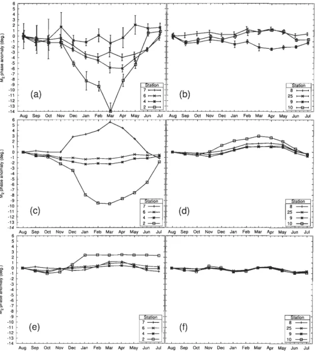
the control simulation. . . .. . .. ... . .. . ... . ... ... . . ... 32 7 Monthly elevation of the M2 tide from observations, the control simulation,
and the ex periment without ice-ocean stress. . . . . . . . . .. 35 8 Monthly phase of the M2 tide from observations, the control simulation, and
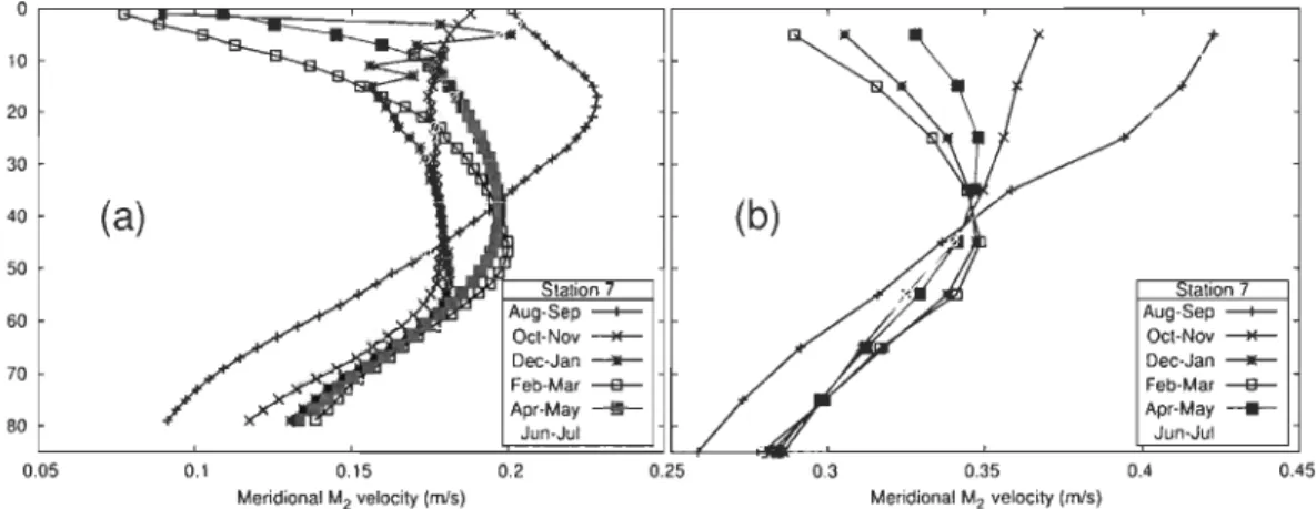
the experiment without ice-ocean stress. . . . . . . . . . . . . . . . . . . 37 9 Multiyear timeseries of amplitude and phase of the M2 tide from observations. 38 10 Meridional M2 velocity profile at station 7 from observations and the control
simulation. . . . . ... . . .. . . .. .. .. . . .. . .... . 38 Il Difference between ice covered and ice free periods for the M2 tide in the
control simulation. ... . . .... .. . ... . ... . . 42 12 Tidal ice drift and under-ice barotropic energy dissipation during maximum
ice cover. .. . . . ... . .... . ... .. .. .. .. .. 44 13 Thiclcness of sea ice and peak-to-peak amplitude of the internaI ice stress
during maximum ice cover. . . . . 46
14 Map of Hudson Bay within the Arctic. 52
15 Salinity at the surface and along 61 ON during the summer according to obser-vations and the simulation. . . . . . . . . . . . 56 16 Volume of freshwater in Hudson Bay over the year. 63 17 Spatial distribution of the river tracer, location and mean discharge of the
18 Freshwater budget for the interior region and seasonal cycle of the wind stress curl. . . . . . . . . . . . . . . . . . . . . . . . . . . . . .. 68 19 Stress at the ocean surface and Ekman transport for two contrasting periods. 72 20 GraduaI release of the river waters of 2004. . .. ... . . . . . 75 21 Schematic for the fluxes of river water after the injection period. 76 22 Top and side views of the conceptual model. . . . . . . . . . 86 23 Climatologie seasonality of the hydrologie, cryospheric, and atmospheric
forcing. . . . . . . . . . . . . . . . . . . . 88
24 Map of Hudson Bay and the sUITounding basins. . 89
25 Mean depth of the interface and mean velocities in the boundary CUITent. . 92 26 Comparison between observed and modeled velocities upstream of the
bound-ary CUITent. ... ... . .. . . .. . . ... . . . ... ... 94 27 Comparison between observations and model results downstream of the
bound-ary CUITent. ... ... . . . . . . . . . . . . . . . . . . . . . .. 95 28 Interannual vari ab ilit y of the river runoff, wind stress curl, export of
freshwa-ter out of the basin, and volume of freshwater within the boundary region and interior. . . . . .... . ... .... . ... . ... . .
29 Vertical profiles of freshwater concentration in the interior region.
30 Comparison between the modeled and observed freshwater flux downstream
97
99 of the boundary CUITent. . . . . . . . . . . . . . . . . . . . . . . . . . 100 31 Sensitivity of the model to changes in hydrologieal and atmospheric forcing. . 103 32 Comparison between climate indices and the storage of freshwater. . . . . . . 106 33 Schematic for the relations between the Arctic Oscillation index, river runoff,and the storage/release of freshwater. . . . . . . . . . . . . . . . 109 34 Comparison between the wind stress curl and observed along-shore velocities. 144 35 Period over which observed daily river runoff data is available for the ten
Background: On Freshwater in the Arctic seas
2The Arctic seas are a series of basins located north of the Arctic Circle (66° N, see Fig. 1 and IHO, 1953). These seas are characterized by waters of relatively low salinity (Fig. 2) and are sometimes collectively described as an estuary of the saltier North Atlantic Ocean (Britannica, 1984) in reference to the brackish zone found downstream of a river and upstream of the salt y ocean.
A number of sources of freshwater contribute to the low salinity of the Arctie seas: wa-ter coming from the Pacifie;. through Bering Strait (Melling et al., 2008, Pacifie waters being generally fresher than their Atlantic counterpart), a positive precipitation minus evaporation rate (Dickson et al., 2007), and a relatively large river runoffboth on the Eurasian and Ameri-can sides (Lammers et al., 2001). The influence ofthe latter is clearly visible in the nearshore areas (Fig. 2).
On long timescales, the budget of Arctic freshwater must be close to a balance where sources of freshwater are cancelled by a net outflow of freshwater. The outflow oceurs on the western and eastern sides of Greenland (white aITOWS, Fig. 3) and crosses the Nordic Seas (Greenland and Norwegian seas) and subarctic seas (Irminger and Icelandie basins, Labrador Sea; see Fig. 1). The signature of this fresh Aretie outftow is noticeable in maps of the surface salinity (Fig. 2), especially on the eastern side of Greenland and on the western side of the Labrador Sea. The latter region holds the Labrador CUITent (Fig. 1), a fresh and cold CUITent extending down to the mid-Atlantic Bight (Chapman and Beardsley, 1989).
The Aretic seas thus appear conceptually as (1) a region holding a large amount of fresh 2Notez que les sections Résumé, Introduction Générale, et Conclusion Générale, sont présentées en anglais et en français dans la thèse. Dans toutes ces sections la version anglaise précède celle en français, le passage d'une langue à l'autre étant souligné par le symbôle :.
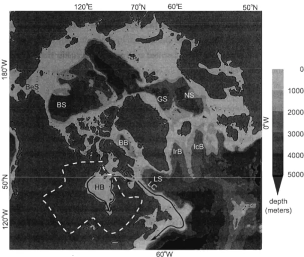
1200 E 700N 600E 500N 5; b co 0 ..-1000 2000 3000 4000 z 5000 b LO 5; b N 600 W
Figure 1: Map of Hudson Bay (HB) within the Arctic region. The drainage basin of HE is delimited by the white dashed line. The circulation of HB 's surface waters and the Labrador CUITent (LC) are schematized by the magenta and black aITOWS, respectively. Also indicated are Bering Strait (BeS), Beaufort Sea (BS), Baffin Bay (BB), Hudson Strait (HS), Green-land Sea (GS), Norwegian Sea (NS), Irrninger Basin (IrB), Icelandic Basin (IcB), and the Labrador Sea (LS).
z
o
L{')s
0 ' N120"E
70
0N
60
0E
50
0N
~ 'b60
0W
+35
34
33
'S' en a. ' - "32
>. :t= c31
CO CI) (J) ü30
-ê
:::J CI)29
co (J) CI)28
27
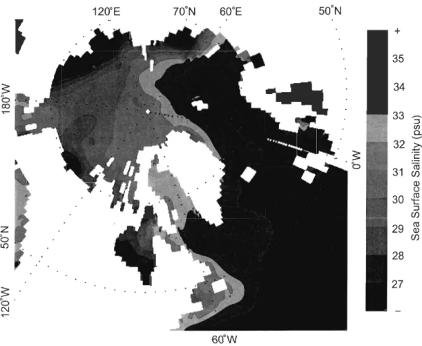
Figure 2: Mean sea surface salinity in the Arctic and subarctic seas, Data taken from the multiannual climatology of Steele et al. (2001, PHC version 2),
Figure 3: Pathway of freshwater from the Arctic seas to the subarctic seas (reproduced from Dickson et al. 2007). Fluxes of freshwater are represented by white arrows and in units of mSv (l mSv
=
103 m3 S-I). The background shows the sea surface deviation from the geoid, with warm (co Id) colors associated with high (low) elevations. Surface geostrophic flow is to the left of gradients in elevation. AlI acronyms are described in Fig. 1 except AR (North American Rivers), RR (Eurasian Rivers), P - E (precipitation minus evaporation), BS (Barrow Strait), WC (Wellington Channel), LS (Landcaster Sound), DS (Davis Strait), GIS (Greenland Ice Sheet), EIC (East Icelandic Current), FS (Fram Strait), and JMC (Jan Mayen Current).waters, and (2) as a faucet that delivers a certain flux of freshwater to the nordic and subarctic seas located downstream (e.g., Fig. 3). The first of these concepts, the freshwater reservoir, is best illustrated by calculating the thickness of liquid freshwater over the Arctic and subarctic seas. This is accomplished by first defining the local concentration in liquid freshwater as:
50 -5 Cfw
=
50 (1)
where 5 0 ~ 5 is a constant salinity reference. With this relation, freshwater is assumed to be mixed within seawater of salinity 50 in a proportion given by Cfw. The freshwater thickness of a water column is obtained by integrating Eq. 1 from the sea surface down to a depth z that could not be reached by river waters, precipitation, or ice melt, so that 5 (z)
=
50 (e.g., McPhee et al., 2009; Proshutinsky et al., 2009, note thatz
varies from one location to another):(2) The resulting freshwater thickness in the Arctic and subarctic areas is shown in Fig. 4. The figure is constructed from climatological salinity data (Steele et al., 2001) and thus represents the locations where freshwater is found on a time-averaged sense. It is seen that freshwater is mainly stored in the Beaufort Sea (see map on Fig. 1), a large basin characterized by a clockwise circulation (the Beaufort Gyre; see Proshutinsky et al., 2009).
Another region of significant freshwater storage is Hudson Bay (see Figs. 4 and 1). Hudson Bay is a shallow inland sea located in northeastem Canada between 50 and 65°N. Even though it is below the Arctic Circle, Hudson Bay is often considered part of the Arc-tic seas because of its anomalous cold climate (Maxwell, 1986) and because of its location upstream of an important subarctic sea (the Labrador Sea).
In summary, the Arctic seas are conceptualized as a reservoir where freshwater is stored, and also as a faucet that maintains a south ward flux of freshwater. The storage is particularly evident in the Beaufort Sea and Hudson Bay areas, while the southward flux
oc-S
b CO T""z
b LO 1200E 700N 600E 500NS
b 600W + 10 (j) ... 9-
Q) Q) E ... 8 ::J en a. ('1') ('1') 7-
0 Q) > 6 +J CIl Q) ... 5 en en Q) c ~ 4 .~ ~ 1-... 3-
Q) CIl ~ ~ 2 en Q) ... LL 1 0Figure 4: Mean thickness of liquid freshwater within the Arctic and subarctic seas (see Eqs. 1 and 2). Data taken from the multiannual c1imatology of Stee1e et al. (2001, PHC version 2).
curs on the eastern side of Greenland and on the western side of Baffin BayjLabrador Sea. These observations summarize the key features of the time-averaged Arctic freshwater bud-get, and the deviations from this mean state will now be introduced in the next section.
Variability of the Freshwaters and its Scientific Implications
The previous section described key features of the mean state in the Arctic seas, in particular its storage of freshwater, and the mean freshwater fluxes toward the nordic and subarctic seas. These parameters are not fixed in time in reality, and constantly fluctuate around their mean value. Such variability is in many cases poody understood (see Melling et al., 2008), first because of the difficulty of adequately sampling these systems, and also because of the inherent complexity of time-varying systems. This leads us to the central question of the thesis:
What are the contrais and impacts of the variability in the Arcticfreshwaters?
The goal of the thesis is thus to better understand the controls and impacts of the sea-sonal and interannual variability of the Arctic freshwaters, or more specifically those of Hud-son Bayas it will be discussed in the next section. This investigation has several scientific implications. First, the variability in the freshwater storage and outflow from the Arctic seas is particularly relevant in the context of the large-scale Meridional ûverturning Circulation (MûC) and its role in the global climate. The pathways of Arctic freshwater cross areas where deep convection normally occurs during the winter (e.g., Dickson et al., 2008), these convec-tive sites being found notably in the Greenland and Labrador seas (Marshall and Schott, 1999). Anomalous high inputs of freshwater can increase the stratification and inhibit the wintertime convection and formation of dense waters (e.g., Lazier, 1980). Depending on the timing and magnitude of the freshwater anomaly over the convective sites, the MûC can be atfected in important ways, with potential impacts for the climate of the N orthern Hemisphere (Rahmstorf et al., 2005; Stouffer et al., 2006; Huisman et al., 2009).
Another issue that involves the whole Arctic region are the changes in climate that are induced by global warming. Although these changes occur on long timescales (30 years and longer), they are clearly visible in observational records, and the Arctic region is amongst the most severely affected regions on the planet (Bernstein et al., 2007). The warming at-mosphere yields a reduced ice cover, so that a larger fraction of the seas is free to exchange freshwater with the atmosphere through evaporation and precipitation. The graduaI release of solid freshwater (snow and ice) through melt/thaw also contributes to enhanced exchanges of freshwater between the atmosphere and the surface. This results in an increasing variability of the air-surface exchanges, i.e. the acceleration of the hydrologic cycle. Although such large-scale shift is difficult to assess with limited observations, there are recent evidences that the increased variability in precipitation is detectable in river runoff records around the Arctic seas (Déry et al., 2009).
Apart from its role in modulating the air-sea fluxes, the ice growth/melt cycle modifies in a profound way the ocean density field and its vertical stratification by brine rejection or melt-induced freshening (e.g., Prinsenberg, 1987). Through this seasonal cycle in stratifica-tion, the sea ice is likely to modulate the turbulent exchanges between the nutrient-rich deep layers and the surface layers where light is available, with consequences upon the primary production (e.g., Sibert et al., 2010). The sea ice cover can also play an important role in the seasonal modulation of the ocean flow within Arctic seas. Where it is thick and strong enough to resist the wind forcing, the ice cover acts as an insulator that inhibits the transfer of momentum from the winds to the ocean. A motionless ice cover can also act as a rough surface against which the ocean currents are damped (e.g., Prinsenberg, 1988a). The advec-tion of the different water masses can be substantially different during the ice-covered period because of these processes.
Perhaps of even greater importance is the variability in the river runoff, the main source of freshwater in the Arctic budget (Dickson et al., 2007). Rivers first have a strong sea-sonal signal caused by the annual melt of snow over the continent. For instance, this freshet
causes the river runoff of Hudson Bay to increase by a factor of four between March and June (Fig. 23, this thesis). River runoff also has a substantial (± 10%) interannual variability
(Shik-lomanov et al., 2000) that is related in sorne cases to the main mode of atmospheric variability north of 200N (the Arctic Oscillation, Déry and Wood, 2004). On top of this natural variabil-ity, hydroelectric developments in sorne of the Arctic seas (e.g., Prinsenberg, 1980) lead to
higher runoff during the winter and lower runoff during the spring and summer seasons.
Understanding the fate of these highly variable river waters within the Arctic seas seems of particular ecological importance. As for the annual ice melt, river runoff is a source of buoyancy that modifies the stability of the water colurnn and the vertical exchanges of prop-erties. Rivers are sometimes also sources of poHutants, notably mercury in the vicinity of hydroelectric developments (e.g., Mailman et al., 2006), and radioactive materials from the Russian rivers to the Kara Sea (Lind et al., 2006). Although the pathway of these substances is often complex, an assessment of their roIe at the ecological level would benefit from the knowledge of the dispersion and residence time of the river waters within the seas.
It was seen in this section that Arctic seas are subject to substantial variability in their freshwater content and inputs. This variability occurs on a continuum of timescales, in partic-ular at the seasonal timescale through the sea ice growth/melt cycle and annual river freshet, and at interannual timescales typical of the large-scale atmospheric variability. This variabil-ity in the freshwaters of the Arctic seas was also seen to have broad implications, both at the global and regional scales. The next section will introduce one particular Arctic basin,
Hudson Bay, where sorne of the issues mentioned will be examined in details.
The Case of Hudson Bay
The previous sections provided a general overview on the freshwaters of the Arctic seas. A comprehensive examination of these issues in aH Arctic seas is obviously beyond the scope of this work, and so the present study focuses upon one Arctic sea in particular, Hudson Bay.
The present section shows that this specific basin includes the necessary components of an Arctic sea, so that its study in particular is useful for the understanding of the Arctic seas in general.
Hudson Bay is a large (~ 900x900km2), shallow (~ 100 m), semi-enclosed sea located in northeastem Canada (Fig. 1; NOAA, 2006). Despite being located below the Arctic Circle, Maxwell (1986) notes that "in comparison with most other lands around the globe at the same latitude in the Northem Hemisphere, those in the vicinity of Hudson Bay and James Bay are abnormally cold". The cold climate over the basin results in the an nuai formation of a com-plete ice cover around December, this ice cover remaining in place until the early summer when it completely disappears (Hochheim and Barber, 2010). The thickness of the ice cover is only known from measurements nearshore and qualitative estimates from satellite images that range between one and two meters during the peak of winter (Markham, 1986; Prin-senberg, 1988b), comparable to the CUITent mean ice thickness in the Arctic Ocean (1.75 m, Kwok and Rothrock, 2009).
Another component of the freshwater balance of the basin is the net precipitation minus evaporation rate. This rate is particularly difficult to estimate from the limited observations but the literature suggests values around 290kgm-2y-l ~ 220km3y-l at 600N (Gill, 1982, his Fig. 2.5). This is much lower than, e.g., the annual freshwater input from the river runoff estimated to be 635 km3 y-Ion average in Hudson and James bays. We note that this value is a substantial (12%) fraction of the total pan-Arctic runoff (Lammers et al., 2001). The river runoff of Hudson Bay is spatially distributed within the basin, the main sources being the Thelon River, Nelson River, and a group of large rivers in James Bay (Fig. 24 of this thesis; see also Déry et al., 2005).
Hudson Bay also exchanges freshwater with its sUITounding basins, but such exchanges are difficult to estimate from the lirnited knowledge of ocean ftow and conditions (see Prin-senberg, 1984, 1986a,b, 1987; Ingram and Prinsenberg, 1998; Granskog et al., 2007, 2009; Lapoussière et al., 2009). Nearly aIl data are collected during the ice-free period
(August-October) and very few instruments were successfully moored over one or more years. Nev-ertheless, the data suggest that Hudson Bay has limited inflows of freshwater. Following . the analysis of Straneo and Saucier (2008a), the flux of freshwater coming from the Arc-tic Archipelago is about 88 km3 y-I relative to 33 psu, which is much smaller than, e.g., the river runoff (635 km3 y-I; see also section 2.3 for a discussion on the appropriate reference salinity for Hudson Bay). Similarly, transects across Hudson Strait (this channel providing the connection with the Atlantic Ocean) suggest that little freshwater enters there since the salinities on the inflowing/northern side of the channel are relatively high (S ~ 33 psu, see Straneo and Saucier, 2008a). This suggests that Hudson Bay imports little freshwater from the surrounding basins, and ex ports its net inputs from river runoff and net precipitation.
From the information gathered in this section, Hudson Bay includes the main compo-nents involved in the freshwater balance of an Arctic sea. First, it has a seasonal ice coyer whose thickness is comparable to that in the Arctic Ocean. Second, Hudson Bay receives a substantial fraction of the pan-Arctic river runoff. Finally, the atmosphere and the surround-ing basins contribute to smaller but significant inputs of freshwater. The next section will present which of these components are investigated within the body of the thesis.
Chapters and Objectives of the Thesis
The goal of this thesis is to better understand the controls and impacts of the variability in Hudson Bay's freshwaters. This central goal is addressed by considering in the first two chapters the seasonal variability of the system, and by examining its interannual variability in the third chapter. More precisely, the objective of the three chapters is to:
C.l Examine the impacts of the seasonal sea ice coyer upon the circulation of the waters. C.2 Investigate the seasonal processes controlling the fate of the river waters.
C.3 Examine the controls behind the interannual variability in storage and export of fresh-water.
The following paragraphs describe in more details these objectives, and the reader is referred to the chapters themselves for further reading.
Chapter I: Impacts of the seasonal sea ice cover upon the circulation of the waters. The circulation of the waters in high latitude seas often shows a significant seasonality. Such sea-sonality may occur through several processes: (1) lower inputs ofbuoyancy (e.g. river runoff) during winter lead to a weaker buoyancy-driven ftow, (2) a motionless ice cover reduces the transfer of momentum from the winds to the ocean, and (3) a motionless ice cover acts as a frictional surface that damps the ocean ftow and spins it down. The objective of the first chapter is to specifically investigate process (3) by examining its effect upon the barotropic tidal currents (that have the advantage of being largely independent of changes in buoyancy inputs and wind forcing). The study builds on the previous work of Godin (1986) and Prin-senberg (1988a) by making use of several new records from year-Iong mooring deployments and a 3-D sea ice-ocean coupled primitive equations model of Hudson Bay.
Chapter 2: Seasonal processes controlling the fate of the river waters. Hudson Bay is characterized by a large annual river input representing the addition of an 80 cm layer of fresh-water if distributed over the whole area of the bay. Moreover, a substantial fraction of this annual runoff is concentrated over a few months during the freshet period. Our understand-ing of the impacts of these river waters at the scale of the bay is however limited as it mostly originates from intantaneous samplings conducted during the ice-free period (Granskog et al., 2007, 2009). The objective of this chapter is to examine the relative importance of the river waters within the annual budget of the bay, and to investigate what processes control their seasonal dispersion and residence time within the basin. To circumvent the difficulty of ob-taining year-Iong measurements, the chapter makes use of the results from a realistic 3-D sea
ice-ocean coupled model.
Chapter 3: Controls behind the interannual variability in storage and export offresh-water. Arctic seas often have significant interannual variability in their atmospheric, cryospheric, and hydrologic forcing. It is a priori not simple to determine how these forcings relate to the
variability in the ocean freshwater storage and export, and through what processes. Follow-ing the results from previous studies (Déry et al., 2005; Proshutinsky et al., 2009; St-Laurent et al., 2010), the objective of this chapter is to specifically examine the role of the variable rivers and variable winds in the storage and export of freshwater. For this purpose, a con-ceptual model of an Arctic sea is designed. The storage of freshwater within the model is controlled by Ekman pumping, and the export of freshwater integrates the etfect of the cryospheric, hydrologic, and atmospheric forcing. The simulated freshwater storage and ex-port are compared to both historical and previously unpublished year-Iong observations from Hudson Bay.
These three chapters address the questions l considered the most important or urgent for the understanding of the freshwater balance of Hudson Bay. Obviously, aU aspects of this freshwater balance could not be covered within the body of the thesis, and a number of open questions remain. Moreover, the results obtained in the study suggest interesting tracks for future research on Hudson Bay in particular and for the Arctic seas in general. These topics (and others) will be discussed together in the General Conclusion section.
À propos des eaux douces des mers arctiques
Les mers arctiques sont un ensemble de bassins situés au nord du Cercle arctique (66°N, voir Fig. 1 et IHO, 1953). Ces mers sont caractérisées par dex eaux relativement peu salées (Fig. 2) et sont parfois décrites collectivement comme un estuaire de l'océan Atlantique (Bri-tannica, 1984) en référence à la zone saumâtre située en aval d'une rivière et en amont des eaux océaniques très salées.
Un certain nombre de sources d'eau douce contribuent à la faible salinité des mers arctiques: les eaux provenant du Pacifique via le détroit de Bering (Melling et al., 2008,
les eaux du Pacifique étant généralement moins salées que celles de l'Atlantique), un bilan précipitation moins évaporation qui est positif (Dickson et a1., 2007), et un apport des rivières relativement grand aussi bien du côté de l'Eurasie que du côté américain (Lam mers et a1., 2001). L'influence des rivières est clairement visible dans les régions côtières (Fig. 2).
Sur de longues échelles temporelles, le bilan des eaux douces arctiques doit être près d'un équilibre où les sources d'eau douces sont compensées par un export net d'eau douce. L'export se produit des côtés ouest et est du Groenland (flèches blanches, Fig. 3) et traverse notamment les mers nordiques (mers du Groenland et de Norvège) et les mers subarctiques (mers d'Irminger, d'Islande et du Labrador; voir Fig. 1). La signature de cet export d'eau douce arctique est visible sur les cartes de salinité de surface (Fig. 2), particulièrement du côté est du Groenland et du côté ouest de la mer du Labrador. Cette dernière mer est l' hôte du courant du Labrador (Fig. 1), un courant froid et peu salé s'étendant jusqu'au sud de la Nouvelle-Angleterre (Chapman and Beardsley, 1989).
Les mers arctiques apparaissent donc conceptuellement comme (1) une région com-prenant une grande quantité d'eaux douces, et (2) un robinet qui produit un flux d'eau douce en direction des mers nordiques et subarctiques situées en aval (e.g., Fig. 3). Le premier de ces concepts, le réservoir d'eau douce, est bien illustré par le calcul de l'épaisseur d'eau douce liquide des mers arctiques et subarctiques. Ce calcul s'effectue en définissant tout d'abord la concentration locale en eau douce liquide (Eq. 1), où S 0 ~ S est une valeur constante de salinité, dite salinité de référence. Dans cette définition, l'eau douce est mélangée avec de l'eau de mer de salinité S 0 en une proportion donnée par Cfw. L'épaisseur d'eau douce d'une colonne d'eau est obtenue en intégrant l'Eq. 1 de la surface de l'eau jusqu'à une profondeur
z
qui n'a pu être atteinte par les eaux des rivières, des précipitations, ou par les eaux de fonte glacielle, de façon à ce que S (z)=
S 0 (Eq. 2, e.g. McPhee et a1., 2009; Proshutinsky et a1., 2009, notez aussi quez
varie d'un endroit à l'autre).L'épaisseur d'eau douce qui en résulte est montrée pour les mers arctiques et subarc-tiques à la Fig. 4. La figure est assemblée à partir de données climatologiques de salinité
(Steele et al., 2001) et représente donc les régions où l'eau douce se trouve en moyenne. Il est apparent que l'eau douce est principalement stockée dans la mer de Beaufort (voir la carte, Fig. 1), un large bassin caractérisé par une circulation dans le sens des aiguilles d'une montre (la gyre de Beaufort; voir Proshutinsky et al., 2009).
Une autre région où le stockage d'eau douce est important est la baie d'Hudson (voir
Figs. 4 et 1). La baie d'Hudson est une mer intérieure peu salée située au nord-est du Canada
entre 50 and 65°N. Bien qu'elle soit située au sud du Cercle arctique, la baie d'Hudson est souvent considérée comme une mer arctique étant donné sont climat anormalement rigoureux
(Maxwell, 1986) et sa position en amont d'un bassin subarctique important (la mer du Labrador). En résumé, les mers arctiques sont représentées conceptuellement comme un réservoir
où l'eau douce est stockée, et comme un robinet maintenant un flux d'eau douce vers le sud.
Le stockage est particulièrement évident dans la mer de Beaufort et dans la baie d'Hudson,
alors que le flux d'eau douce vers le sud est visible du côté est du Groenland et du côté ouest de la baie de Baffin ou de la mer du Labrador. Ces observations résument les éléments clefs du bilan moyen des eaux douces arctiques, et l'existence de déviations par rapport à cet état
moyen sera discutée dans la prochaine section.
Variabilité des eaux douces et ses implications scientifiques
La section précédente a décrit les éléments clefs de l'état moyen des mers arctiques,
en particulier le stockage de l'eau douce, et la présence d'un flux moyen dirigé vers les mers nordiques et subarctiques. Ces paramètres ne sont toutefois pas fixes dans le temps, et
fluctuent constamment autour de leur valeur moyenne. Cette variabilité temporelle est en-core largement inconnue (voir Melling et al., 2008), tout d'abord à cause de la difficulté
d'échantillonner de façon adéquate ces systèmes, et aussi à cause de la complexité inhérente aux systèmes non-stationnaires (variables dans le temps). Cela nous mène à la question
Quels sont les impacts de la variabilité des eaux douces arctiques, et quels processus la contrôlent?
Le but de cette thèse est donc de mieux comprendre ce qui contrôle la variabilité saisonnière et interannuelle des eaux douces arctiques, et quels sont ses impacts. Cette recherche a plusieurs portées scientifiques. Tout d'abord, la variabilité du stockage et de l'export d'eau douce des mers arctiques est particulièrement intéressant dans le contexte de la circulation méridionale atlantique (Meridional ûverturning Circulation, MûC) et son rôle dans le climat global. Le parcours des eaux douces arctiques traverse des régions où une convection pro-fonde se produit normalement durant l'hiver (e.g., Dickson et al., 2008), ces sites convectifs étant notamment présents dans les mers du Groenland et du Labrador (Marshall and Schott, 1999). Des apports anormalement élévés d'eau douce peuvent accroître la stratification de ces régions et inhiber la convection hivernale et la formation d'eau dense (e.g., Lazier, 1980). Dépendant du synchronisme et de l'amplitude de l'anomalie en eau douce au dessus des sites convectifs, la MûC peut être affectée de façon importante, avec des impacts potentiellement importants pour le climat de l'Hémisphère Nord (Rahmstorf et al., 2005; Stouffer et al., 2006; Huisman et al., 2009).
Une autre question qui implique l'ensemble des mers arctiques est le changement cli-matique induit par le réchauffement global. Malgré que ces changements s'effectuent sur de longues échelles temporelles (30 ans et plus), ils sont clairement visibles dans les enreg-istrements expérimentaux, et l'Arctique est appelée à être une des régions les plus touchées par le réchauffement (Bernstein et al., 2007). Un tel réchauffement mène à une couver-ture glacielle réduite, signifiant qu'une proportion plus grande des mers est libre d'effectuer des échanges d'eau douce avec l'atmosphère (via l'évaporation et les précipitations). La libération graduelle des eaux douces autrefois stockées sous phase solide (neige et glace) con-tribue aussi à des échanges accrus entre l'atmosphère et la surface terrestre. Ces changements résultent en une variabilité accrue des échanges air-surface, c'est-à-dire en l'accélération du cycle hydrologique. Bien que ce genre de changement à grande échelle soit difficile à
ob-server avec un nombre limité d'instruments, des observations récentes montrent que la vari-abilité croissante des précipitations est détectable dans les jauges de débit des rivières tout autour de l'Arctique (Déry et al., 2009).
Outre son rôle dans la modulation des échanges air-océan, le cycle de croissance et de fonte glacielle modifie de façon profonde le champ de densité et sa stratification verticale à travers le rejet de sel lors de la croissance ou le rejet d'eau douce lors de la fonte (e.g., Prinsenberg, 1987). De par cette modulation saisonnière de la stratification, la glace de mer est susceptible d'aussi moduler les échanges turbulents entre les couches profondes riches en nutriments et les couches plus superficielles où la lumière est disponible, ceci ayant des conséquences sur la production primaire (e.g., Sibert et al., 2010). La couverture glacielle peut aussi jouer un rôle important dans la modulation saisonnière de la circulation océanique au sein des mers arctiques. Là où elle est épaisse et suffisamment rigide pour résister à la trac-tion du vent, la couverture glacielle agit tel un isolant qui inhibe le transfert de momentum des vents à l'océan. Une couverture glacielle immobile peut aussi agir telle une surface rugueuse contre laquelle les courants océaniques sont amortis (e.g., Prinsenberg, 1988a). L'advection des différentes masses d'eau s'en trouve alors substantiellement modifiée pendant la période hivernale.
Peut-être d'encore plus grande importance est la variabilité de l'apport des rivières, ces rivières représentant la principale source d'eau douce dans l'Arctique (Dickson et al., 2007).
Les rivières comportent tout d'abord un fort signal saisonnier causé par la fonte annuelle de la neige au dessus des continents. Par exemple, cette période de fonte s'accompagne d'un débit des rivières qui quadruple de mars àjuin dans la baie d'Hudson (Fig. 23). Le débit des rivières comporte aussi une variabilité interannuelle substantielle (± 10%) (Shiklomanov et al., 2000) qui est liée dans certains cas au principal mode de variabilité atmosphérique au nord du 20e parallèle (l'oscillation arctique, Déry and Wood, 2004). Outre cette variabilité naturelle, des développements hydroélectriques dans certaines mers arctiques (e.g., Prinsenberg, 1980) mènent à des débits plus élevés pendant l'hiver et des débits moins élevés au printemps et à
l'été.
La compréhension du parcours et du destin des eaux des rivières arctiques semble être d'une importance particulière pour l'écologie de ces systèmes. De façon analogue à la fonte annuelle des glaces, l'apport des rivières représente une source de flottabilité qui modifie la stabilité de la colonne d'eau et l'échange vertical des propriétés. Les rivières sont aussi parfois sources de polluants, notamment du mercure à proximité des développements hy-droélectriques (e.g., Mailman et al., 2006), et aussi de substances radioactives dans le cas des rivières russes se jettant dans la mer de Kara (Lind et al., 2006). Bien que le chemine-ment exact de ces substances soit souvent complexe (notamchemine-ment à cause de leur interaction avec les organismes marins), toute étude de la portée de ces substances au niveau écologique bénéficierait de la connaissance de leur dispersion et de leur temps de résidence dans les mers arctiques.
Il a été vu dans cette section que les mers arctiques sont sujettes à une variabilité tem-porelle substantielle dans leurs apports et leur contenu en eau douce. Cette variabilité apparait sur un continuum d'échelles temporelles, en particulier à l'échelle saisonnière de par le cycle de production/fonte glacielle, et aux échelles interannuelles typiques de la variabilité atmo-sphérique de grande échelle spatiale. Il a aussi été vu que cette variabilité des eaux douces arctiques a plusieurs implications, aussi bien aux échelles régionale que globale. La prochaine section introduiera une mer arctique en particulier, la baie d'Hudson, où certains éléments de la problématique décrite ci-haut seront examinés en détails.
Le cas de la baie d'Hudson
Les sections précédentes ont procuré un aperçu général des eaux douces des mers arc-tiques et des questions scientifiques s'y rapportant. Un examen approfondi de ces questions dans l'ensemble des mers arctiques est bien évidemment au delà des objectifs du présent tra-vail, et c'est pourquoi cette étude se concentre plutôt sur une mer arctique en particulier, la
baie d'Hudson. La section présente montre que ce bassin inclut les composantes nécessaires d'une mer arctique, et donc que l'étude de la baie d'Hudson en particulier représente une avancée pour la compréhension des mers arctiques en général.
La baie d'Hudson est une large (~ 900 x 900 km2
) mer, peu profonde (~ 100 m), par-tiellement refermée, et située au nord-est du Canada (Fig. 1; NOAA, 2006). Bien qu'elle soit située au sud du Cercle arctique, Maxwell (1986) note que
«
in comparison with most other lands around the globe at the same latitude in the Northem Hemisphere, those in the vicinity of Hudson Bay and James Bay are abnormally cold». Le climat froid au dessus du bassin résulte chaque année en la formation d'une couverture glacielle complète en décembre, cette couverture demeurant en place jusqu'à l'été où elle disparait complètement (Hochheim and Barber, 2010). L'épaisseur de la couverture de glace n'est connue que de quelques mesures effectuées près des côtes, et d'estimations qualitatives (e.g. le type/catégorie de la glace) obtenues d'images satellitaires; des épaisseurs variant entre un et deux mètres sont rapportées au plus fort de l'hiver (Markham, 1986; Prinsenberg, 1988b), comparable à l'épaisseur moyenne actuelle dans l'océan arctique (1.75 m, Kwok and Rothrock, 2009).Une autre composante du bilan des eaux douces du basin est celle des précipitations nettes (précipitation moins évaporation). Les précipitations nettes sont difficiles à évaluer avec le peu de mesures disponibles, mais la littérature suggère des valeurs autour de 290 kg m-2 y-l ~ 220 km3 y-l à 600N (Gill, 1982, sa Fig. 2.5). Cette valeur est beaucoup plus faible que, par exemple, l'apport annuel des rivières qui est estimé à 635 km3 y-l en moyenne dans les baies d'Hudson et de James. On note aussi que cet apport des rivières représente une proportion substantielle (12%) de l'apport total des rivières arctiques (Lam mers et al., 2001). Les rivières de la baie d'Hudson sont spatialement distribuées sur le bassin, les principales sources étant les rivières Thelon, Nelson, et un groupe de rivières situées dans la baie James (Fig. 24 de cette thèse; voir aussi Déry et al., 2005).
La baie d'Hudson échange aussi de l'eau douce avec les bassins avoisinants, mais ces échanges sont difficilement quantifiables à partir des connaissances limitées des conditions
océaniques et de leur circulation (voir Prinsenberg, 1984, 1986a,b, 1987; Ingram and Prin-senberg, 1998; Granskog et al., 2007, 2009; Lapoussière et al., 2009). Pratiquement toutes les données sont recueillies pendant la période libre de glace (août à octobre) et très peu d'instruments sont demeurés mouillés et fonctionnels sur des périodes d'une année ou plus. Malgré ces difficultés, les observations suggèrent que la baie d' Hudson reçoit peu d'eau douce des bassins voisins. Suivant l'analyse de Straneo and Saucier (2008a), le flux d'eau douce provenant de l'archipel canadien est environ 88 km3 y-l relatif à 33 psu, ce qui est beaucoup plus faible que, e.g., l'apport dû aux rivières (635 km3 y-l ; voir aussi la section 2.3 pour une discussion sur le choix de la salinité de référence). De façon similaire, des sections latérales dans le détroit d'Hudson (ce détroit permettant le lien avec l'océan Atlantique) suggèrent
que bien peu d'eau douce y entre étant donné que les salinités du côté nord (où l'eau entre) sont relativement élevées (S ~ 33 psu, voir Straneo and Saucier, 2008a). Ces observations suggèrent que la baie d'Hudson importe bien peu d'eau douce des bassins avoisinants, et exporte principalement des eaux douces provenant des rivières et des précipitations.
Des informations rassemblées dans cette section, il est évident que la baie d'Hudson comporte les principales composantes impliquées dans le bilan des eaux douces d'une mer arctique. Tout d'abord, la baie a une couverture glacielle dont l'épaisseur est comparable à celle de l'océan arctique. Puis, la baie d'Hudson reçoit une proportion substantielle de l'apport total des rivières arctiques. Finalement, l'atmosphère et les bassins avoisinants con-tribuent à des apports d'eau douce faibles mais néanmoins significatifs. La section suivante présentera lesquelles de ces composantes feront l' object d'une étude approfondie dans le cadre de cette thèse.
Chapitres et objectifs de la thèse
Le but de cette thèse est de mieux comprendre ce qui contrôle la variabilité des eaux douces de la baie d'Hudson et quels sont les impacts de cette variabilité. Les deux premiers
chapitres de la thèse considèrent la variabilité saisonnière du système, alors que le troisième porte sur la variabilité interannuelle du système. Plus spécifiquement, l'objectif de chacun des trois chapitres est de :
C.1 Examiner les impacts du cycle glaciel saisonnier sur la circulation des eaux.
C.2 Étudier les processus saisonniers déterminant le parcours et le devenir des eaux des rivières.
C.3 Examiner les processus contrôlant la variabilité interannuelle du stockage et de l'export de l'eau douce.
Les paragraphes qui suivent décrivent ces objectifs, et le lecteur est référé aux chapitres eux mêmes pour plus de détails.
Chapitre I : Impacts du cycle glaciel saisonnier sur la circulation des eaux. La circu-lation des eaux aux hautes latitudes montre souvent une certaine saisonnalité. Cette saison-nalité peut être liée à différents processus: (1) une diminution des apports en flottabilité durant l'hiver (e.g. débit des rivières) qui engendre un ralentissement de l'écoulement estuar-ien, (2) une couverture de glace immobile réduit le transfert de momentum des vents jusqu'à l'océan, et (3) une couverture de glace immobile agit comme une surface rugueuse qui amor-tit l'écoulement océanique et la décélère. L'objectif du premier chapitre est spécifiquement d'étudier le processus (3) en examinant son effet sur les courants de marée barotrope (qui ont l'avantage d'être largement indépendants des apports de flottabilité et des vents). Ce chapitre dépasse les études précédentes de Godin (1986) et Prinsenberg (1988a) en faisant l'usage de nombreux enregistrements provenant de mouillages déployés sur plusieurs années, et en utilisant un modèle 3-D couplé océan-glace de mer pour la baie d'Hudson.
Chapitre 2 : Processus saisonniers déterminant le parcours et le devenir des eaux des
rivières. La baie d'Hudson est caractérisée par un important apport des rivières, cet apport représentant l'ajout annuel d'une couche d'eau douce de 80cm lorsque distribué sur la super-ficie du bassin. Plus encore, cet apport est concentré pendant les quelques mois du printemps où a lieu la fonte des neiges sur le continent. Notre compréhension des impacts à l'échelle
de la baie de ces eaux des rivières est toutefois limitée car nos connaissances originent la plupart du temps d'échantillonnages instantanés effectués pendant la période libre de glace (Granskog et al., 2007, 2009). L'objectif de ce chapitre est d'examiner l'importance relative des eaux des rivières dans le bilan annuel des eaux douces de la baie, et de rechercher quels processus contrôlent leur dispersion saisonnière et leur temps de résidence dans le bassin. Afin de coutoumer la difficulté associée à l'obtention de mesures in situ, le chapitre fait us-age des résultats d'un modèle réaliste (3-D couplé océan-glace de mer).
Chapitre 3 : Processus déterminant la variabilité interannuelle du stockage et de ['
ex-port des eaux douces. Les mers arctiques comportent souvent une variabilité interannuelle significative dans leurs forçages atmosphériques, cryosphériques, et hydrologiques. Il est a priori difficile de déterminer comment ces forçages sont liés à la variabilité du stock-age et de l'export des eaux douces, et par quels processus. Suivant les résultats d'études précédentes (Déry et al., 2005; Proshutinsky et al., 2009; St-Laurent et al., 2010), l'objectif de ce chapitre est d'examiner spécifiquement le rôle de la variabilité des rivières et des vents dans le stockage et l'export d'eau douce. À cette fin, un modèle conceptuel d'une mer arc-tique est développé. Le stockage d'eau douce dans ce modèle est contrôlé par le pompage d'Ekman, et l'export d'eau douce intègre les effects du forçage cryosphérique, hydrologique,
et atmosphérique. Le stockage et l'export simulés sont comparés à des données historiques et à d'autres observations présentées pour la première fois.
Ces trois chapitres portent sur les questions que j'ai considérées comme les plus impor-tantes ou pressantes pour la compréhension du bilan des eaux douces dans la baie d'Hudson.
Évidemment, tous les aspects de ce bilan n'ont pu être couverts dans la thèse, et un nom-bre de questions demeurent ouvertes. De plus, les résultats obtenus dans la thèse suggèrent d'intéressantes pistes pour des études subséquentes sur la baie d'Hudson en particulier et sur les mers arctiques en général. Ces éléments (et bien d'autres) seront discutés en commun dans la section Conclusion Générale.
1.1 Abstract
New observations from eight moorings located in Foxe Basin, Hudson Strait, and Hud
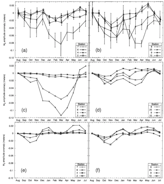
-son Bay, are used to study the sea-sonal variability of the M2 tide. Significant seasonal varia-tions of the M2 surface elevation are found in aIl these regions and at aIl seasons. The largest variations occur during winter while both elevation increase (Hudson Strait) and decrease (Hudson Bay, Foxe Basin) are observed. These variations are found recurrent at the stations
where multiyear observations are available. Observations from a velocity profiler are consis -tent with a seasonal damping of the tides because of friction under ice. Numerical simulations with a sea ice-ocean coupled model and realistic forcing qualitatively reproduce most of the features of the observed variability. The simulations show that the winter M2 variations are essentially caused by the under-ice friction, albeit with strong regional differences. Under-ice friction mostly occurs in a limited region (Foxe Basin) and can account for both increased and decreased M2 elevations during winter.
De nouvelles observations provenant de huit mouillages situés dans le bassin de Foxe,
le détroit d'Hudson, et la baie d'Hudson, sont utilisés pour l'étude de la variabilité saisonnière de la marée M2 . Des variations saisonnières significatives dans l'amplitude de M2 sont
ob-servées dans toutes ces régions et en toutes saisons. Les variations les plus grandes se pro-duisent pendant l'hiver alors que des augmentations (détroit d'Hudson) et des diminutions (baie d'Hudson, bassin de Foxe) de l'amplitude sont observées. Ces variations sont montrées
récurrentes aux stations où sont disponibles des relevés couvrant plusieurs années. Des
ob-servations provenant d'un courantomètre couvrant la colonne d'eau sont cohérents avec un amortissement saisonnier des marées causé par la friction à l'interface glace-océan. Des
sim-ulations numériques avec un modèle couplé océan-glace de mer et des forçages réalistes reproduisent de façon qualitative la plupart des caractéristiques de la variabilité observée. Ces simulations montrent que les variations hivernales de M2 sont principalement causées par la friction contre la glace, avec toutefois de fortes différences spatiales. La friction contre la glace se produit surtout dans une région limitée (basse de Foxe) et elle explique tout aussi bien l'augmentation que la diminution des amplitudes de M2 pendant l'hiver.
1.2 Introduction
Seasonal changes in the characteristics of Arctic tidal waves have been reported as early as 1917 (Zubov, 1943). The changes often consist in a decrease of tidal elevations during winter (Zubov, 1943; Godin and Barber, 1980; Murty, 1985; Johnson and Kowalik, 1986). The lower elevations suggest a damping mechanism that dissipates tidal energy during winter. A potential damping mechanism is the friction produced at the interface between the ice and the ocean. For instance, Sverdrup (1927) described the near-surface shear layer formed by tidal currents underneath the ice.
Under-ice friction is particularly expected in the marginal seas that are characterized
by significant tides and ice cover. The horizontal stress at the ice-ocean interface is often parameterized as the stress over the sea Hoor (a quadratic stress). Sea ice is seldom motionless so the stress is proportional to the relative velocity between ice and water (e.g., Pease et al., 1983). High levels of under-ice friction are expected during high ice concentration periods, i.e. when the ice cover is complete. The ice plates are then confined by shorelines and their mobility is significantly hampered. The relative velocity between the ice and the tidal current increases and the stress exerted over the tidal stream becomes significant.
Recent studies have shown that the interaction between ice and tides may play a sig-nificant role in the c1imate of ice-covered seas. The model study from Polyakov and Martin (2000) showed that tidal mixing helps in transporting heat to the sea surface and is important
in the establishment and maintenance of a recurrent polynya in the Okhotsk Sea (see also observations from Martin et al. 2004). In a similar way, the parameterization of tides in the Arctic Ocean Model Intercomparison Project (AOMIP) led to a more realistic ventilation of ocean heat through atmosphere-ocean exchanges in tidalleads (Holloway and Proshutinsky, 2007). Heil et al. (2008) also studied the drift and deformation of sea ice in the Weddell Sea using an array of drifting ice buoys. The sea ice velocity variance over the continental shelf was found to be dominated at sernidiumal frequencies by tides rather than inertial response. The variability of the sea-ice deformation was dorninated by sub-daily processes (tides and inertial response) and low-frequency atmospheric changes played a secondary role.
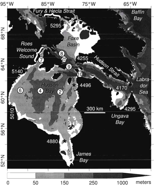
While the importance of tides in the c1imate of ice-covered seas is investigated, the effect of ice upon tides remains elusive. Existing studies either show observed tidal varia-tions alone (e.g., Prinsenberg and Hamilton, 2005) or model results without comparison with seasonal observations (Kagan et al., 2008). The precise role of the ice-ocean stress in the observed tidal variations is thus unc1ear. The Hudson Bay System (HBS), a shallow inland sea located in northem Canada (see Fig. 5), is an appropriate region to examine this process. The sea ice cover in HBS has a concentration c that seasonally fluctuates from c
=
0 (gen-erally ice-free conditions, around September) to 0.95 < c < 1 (complete ice cover, around March). Significant seasonal variability of tides was reported in HBS by Godin (1986) and Prinsenberg (l988a) who both suggested that the changes are related to the ice cover.In this work, we re-examine the seasonal variations of the principal tidal wave (M2) in the HBS using new observations and results from a sea ice-ocean coupled 3-D numerical model. The new observations extend the work from Godin (1986) and Prinsenberg (1988a) by providing year-Iong coverage in Foxe Basin, Hudson Strait, and Hudson Bay. Section 1.3 describes the instruments and the numerical model used throughout the study. Section 1.4 shows the results from the observations. Significant seasonal changes in M2 elevations are found throughout the Hudson Bay System. The numerical model is used in section 1.5 to examine the relationship between the under-ice friction and the seasonal variability of the
95°W
z
oco
CDz
o ~ CDz
oo
CDz
°
CD Lnz
o (\J Lno
85°W
65°W
50
150
250
1000
meters
Figure 5: Map of the Hudson Bay System (HBS: Hudson Bay, Hudson Strait, Foxe Basin, James Bay, and Ungava Bay) with neighboring Labrador Sea and Baffin Bay. The stations
used for the seasonal analyses are indicated by circled numbers. The stations used in Table 2
M2 tide. It is found that the winter variations of the M2 tide are essentially caused by the
under-ice friction, albeit with strong regional differences. Finally, these results are discussed in section 1.6.
1.3 Method
1.3.1 Observations
Observed data (Saucier et al., 2004b) are from CTDs (Conductivity, Temperature and Depth measuring instruments) moored at eight different stations (see Fig. 5). Four stations are located in Hudson Bay, two are in Hudson Strait, and two are in southem Foxe Basin. All stations were occupied with CTDs for at least one year during August 2003-August 2006 (see Table 1 for the duration of the timeseries and the depth of the instruments). Pressure recorded every 30 min is used to study the seasonal modifications in the M2 tide. We restrict our analyses to the M2 wave since it dominates the tidal records and the currents in general
(e.g., Prinsenberg, 1987).
The pressure record from each mooring is segmented into slightly overlapping monthly timeseries (32 days) for sequential harmonie analyses (Foreman, 1978; Mofjeld, 1986; Pawlow-icz et al., 2002). This produces values for M2 Psg" surface pressure and phase. The symbol Ps represents sea surface density and g
=
9.8 m ç2. The symbol" is the sea surface elevation above the mean sea level { The sea surface elevation " and the me an sea level ( include the submerged fraction of sea ice (see Mellor and Kantha, 1989, Fig. 1).From the observations, the M2 Psg" pressures typically deviate by 3 x 10⁻² dbars from the annual mean. Such a large pressure deviation can hardly be related to changes in sea surface density (Ps). From observations at 25 m depth, and the model by Saucier et al. (2004a), monthly-averaged densities change by at most 2 kg m-3 over a year. For a tidal elevation with fixed amplitude "
=
1 m, the resulting surface wave pressure change isTable 1: Location, period and depth of the pressure records used in the studya. Station
2003 2004 2005
Depth H (ru) (ru)2
b X X148 155
4
C X X X35
205
6
X63
108
7
X100 103
8
X440 443
9
X149 152
10
X3
7
4 3
77
25
X363
366
a Ail timeseries begin in August of the indicated year and last one year. H is the depth of the water column. bThe 2004 timeseries is used in Fig. 7.