Publisher’s version / Version de l'éditeur: Technical Report, 2006-02
READ THESE TERMS AND CONDITIONS CAREFULLY BEFORE USING THIS WEBSITE.
https://nrc-publications.canada.ca/eng/copyright
Vous avez des questions? Nous pouvons vous aider. Pour communiquer directement avec un auteur, consultez la première page de la revue dans laquelle son article a été publié afin de trouver ses coordonnées. Si vous n’arrivez pas à les repérer, communiquez avec nous à PublicationsArchive-ArchivesPublications@nrc-cnrc.gc.ca.
Questions? Contact the NRC Publications Archive team at
PublicationsArchive-ArchivesPublications@nrc-cnrc.gc.ca. If you wish to email the authors directly, please see the first page of the publication for their contact information.
Archives des publications du CNRC
For the publisher’s version, please access the DOI link below./ Pour consulter la version de l’éditeur, utilisez le lien DOI ci-dessous.
https://doi.org/10.4224/12340992
Access and use of this website and the material on it are subject to the Terms and Conditions set forth at Impact of climate change on arctic shipping : Vessel damage and regulations
Kubat, Ivana; Collins, Anne; Gorman, Bob; Timco, Garry
https://publications-cnrc.canada.ca/fra/droits
L’accès à ce site Web et l’utilisation de son contenu sont assujettis aux conditions présentées dans le site LISEZ CES CONDITIONS ATTENTIVEMENT AVANT D’UTILISER CE SITE WEB.
NRC Publications Record / Notice d'Archives des publications de CNRC:
https://nrc-publications.canada.ca/eng/view/object/?id=2375617b-cac0-4ea0-b377-da8ca9e909cb https://publications-cnrc.canada.ca/fra/voir/objet/?id=2375617b-cac0-4ea0-b377-da8ca9e909cb
Impact of Climate Change on Arctic Shipping: Vessel
Damage and Regulations
Ivana Kubat, Anne Collins, Bob Gorman and Garry Timco
2 3 2 2 3 2 2 2 2 2 2 2 2 2 3 2 2 2 2 -40 -30 -20 -10 0 10 20 30 40 Ice Numeral ZONE DATE IN
JAN. FEB. MAR. APR. MAY JUN. JUL. AUG. SEP. OCT. NOV. DEC.
RANGE OF ICE NUMERALS
NORTHWEST PASSAGE - ZONE 11 1998 (WARM YEAR) Highest IN Lowest IN Modified Zone-Date window Technical Report CHC-TR-038 February 2006
Impact of Climate Change on Arctic Shipping: Vessel
Damage and Regulations
Ivana Kubat, Anne Collins, Bob Gorman and Garry Timco
Technical Report CHC-TR-038
February 2006
Impact of Climate Change on Arctic Shipping: Vessel
Damage and Regulations
Ivana Kubat1, Anne Collins1, Bob Gorman2 and Garry Timco1 1Canadian Hydraulics Centre
National Research Council of Canada Ottawa, Ont. K1A 0R6
Canada
2
Enfotec
25 Tapiola Cres. Suite 206 Ottawa, Ont. K1P 2J7
Canada
Technical Report CHC-TR-038
The purpose of this project was to assess the impact of climate change on the likelihood and severity of damage to vessels operating in Artic waters, and address the impacts of climate change on the pollution prevention regulations governing ship traffic in the Arctic. Transport Canada has the responsibility for regulating Arctic shipping in Canada as part of the Arctic Shipping Pollution Prevention Regulations. A Zone/Date System (ZDS) is used North of the 60° latitude. The ZDS is based on historical data of ice conditions up to the early 1970’s and on the premise that the ice conditions are consistent from year-to-year. The ZDS consists of sixteen geographic regions (Zones) and an associated Table that indicates the dates that each class of vessel is allowed in each geographical region. The Arctic Ice Regime Shipping System (AIRSS) is used by vessels wishing to access the Arctic Control Zones outside permissible dates for the vessels. The AIRSS, in contrast, allows shipping based on the actual, not historical, ice conditions. In this project a methodology to evaluate Canada’s Arctic shipping Regulations was developed. Length of the shipping season in the Northwest Passage and Hudson Strait for a colder than normal and a warmer than normal year was analyzed by both the ZDS and the AIRSS, and both systems were then compared. The ice conditions in the North West Passage (NWP) shipping lanes and the access routes to the Port of Churchill in Hudson Strait were analyzed and a potential of damage to vessels was assessed. Based on this study advice will be provided to Transport Canada regarding the need for regulatory reform in the Arctic due to climate change.
1. Introduction and Objectives... 1
2. Review of Previous Climate Change Work in the Arctic ... 2
3. Regulatory Shipping Systems... 6
4. CIS Data – Air Temperatures ... 10
4.1 Annual Cumulative Melting Degrees ... 10
4.2 Length of Melting Season... 19
5. Annual Variability in Summer Temperatures across the Canadian Arctic... 25
6. Methodology... 32
6.1 Data processing... 32
6.2 Data Analysis... 33
7. Analysis of the Northwest Passage ... 39
7.1 Zones 4 and 12... 39
7.2 Zone 11 and 7 ... 40
7.3 Zone 6 ... 43
7.4 Zone 13 ... 44
8. Analysis of Access Route to Churchill ... 45
8.1 Zone 15 (Main and Alternate Routes) ... 45
8.2 Zone 14 (Main and Alternate Routes) ... 45
8.3 Zone 16 (Alternate Route)... 47
9. Potential Damage to Vessels... 48
9.1 Ice Conditions in the Northwest Passage ... 52
9.2 Ice Conditions in the Hudson Strait and Hudson Bay ... 52
10. Conclusions and Recommendations ... 53
11. Acknowledgement ... 54
12. References... 55 APPENDIX A. Methodology to Evaluate Canadian Regulations – Data Processing . A-1 APPENDIX B. Range and Count of Ice Numerals ... B-1 APPENDIX B-1. Northwest Passage ... B-3 APPENDIX B-2. Access Routes to Port of Churchill... B-17 APPENDIX B-3. Segment Routes ... B-29 APPENDIX C. Ice Conditions Causing Changes in IN Values ... C-1 APPENDIX D. Ice Coverage in Shipping Routes ... D-1 APPENDIX D-1. Northwest Passage... D-3 APPENDIX D-2. Access Routes to Port of Churchill... D-11
Figure 1: Shipping Safety Control Zones in Canada (as per Zone/Date System) (ASPPR, 1989)... 6 Figure 2: Shipping Safety Control Zones in Canada, Meteorological Stations used for Air Temperature Analysis (from left on NWP route: Inuvik, Tuktoyaktuk, Cambridge Bay, Resolute, Pond Inlet; from left in Hudson Bay: Coral Harbour, Iqaluit), and Shipping Routes in Northwest Passage and in Hudson Bay... 10 Figure 3: Cumulative Melting Degree (CMD, calculated as Cumulative Air Temperature above 0°C) from selected Met Stations (year 1968 – 2004) ... 11 Figure 4: Expected Cumulative Melting Degree trendline at Cambridge Bay projected to year 2020 based on 1968 to 2003 dataset... 11 Figure 5: Expected Cumulative Melting Degree trendline at Coral Harbour projected to year 2020 based on 1968 to 2003 dataset... 12 Figure 6: Expected Cumulative Melting Degree trendline at Inuvik projected to year 2020 based on 1968 to 2003 dataset... 12 Figure 7: Expected Cumulative Melting Degree trendline at Iqaluit projected to year 2020 based on 1968 to 2003 dataset... 13 Figure 8: Expected Cumulative Melting Degree trendline at Pond Inlet projected to year 2020 based on 1968 to 2003 dataset... 13 Figure 9: Expected Cumulative Melting Degree trendline at Resolute projected to year
2020 based on 1968 to 2003 dataset... 14 Figure 10: Expected Cumulative Melting Degree trendline at Tuktoyaktuk projected to
year 2020 based on 1968 to 2003 dataset... 14 Figure 11: Cumulative melting degree trendline per decade at Cambridge Bay (years
1968–1979, 1980-1989, 1990-2000, above 2000) ... 15 Figure 12: Cumulative melting degree trendline per decade at Coral Harbour (years
1968–1979, 1980-1989, 1990-2000, above 2000) ... 15 Figure 13: Cumulative melting degree trendline per decade at Inuvik (years 1968–1979, 1980-1989, 1990-2000, above 2000) ... 16 Figure 14: Cumulative melting degree trendline per decade at Iqaluit (years 1968–1979, 1980-1989, 1990-2000, above 2000) ... 16 Figure 15: Cumulative melting degree trendline per decade at Pond Inlet (years 1972–
1979, 1980-1989, 1990-2000, above 2000) ... 17 Figure 16: Cumulative melting degree trendline per decade at Resolute (years 1968–
1979, 1980-1989, 1990-2000, above 2000) ... 17 Figure 17: Cumulative melting degree trendline per decade at Tuktoyaktuk (years 1968–
1979, 1980-1989, 1990-2000, above 2000) ... 18 Figure 18: Cumulative Melting Degree (CMD, calculated as Cumulative Air Temperature above 0°C) averaged over the Canadian Arctic ... 19 Figure 19: Number of days with air temperature above –1.8°C at Cambridge Bay
throughout period of 1968-2003 ... 20 Figure 20: Number of days with air temperature above –1.8°C at Coral Harbour
throughout period of 1968-2003 ... 20 Figure 21: Number of days with air temperature above –1.8°C at Inuvik throughout
Figure 22: Number of days with air temperature above –1.8°C at Iqaluit throughout
period of 1968-2003 ... 21
Figure 23: Number of days with air temperature above –1.8°C at Pond Inlet throughout period of 1975-2003 ... 22
Figure 24: Number of days with air temperature above –1.8°C at Resolute throughout period of 1968-2003 ... 22
Figure 25: Number of days with air temperature above –1.8°C at Tuktoyaktuk throughout period of 1974-2003 ... 23
Figure 26: Number of Stations Reporting 5 Highest Cumulative Melting Degrees... 26
Figure 27: Number of Stations Reporting 5 Lowest Cumulative Melting Degrees ... 26
Figure 28: AO/NAO pattern since 1950 as calculated by British Met Office ... 28
Figure 29: Temperature Deviation over Canada during the El Niño winter of 1982/83 .. 29
Figure 30: Temperature Deviation over Canada during the El Niño winter of 1991/92 .. 30
Figure 31: Route Segments in the Northwest Passage and in Hudson Strait... 33
Figure 32: Northwest Passage route crossing six different ice regimes within Zone 11.. 34
Figure 33: Range of Ice Numerals calculated from CIS ice charts for NWP shipping route in Zone 11, throughout year 1986 (colder than normal in period 1968-2004).. 35
Figure 34: Range of Ice Numerals Calculated from CIS ice charts for NWP shipping route in Zone 11, throughout year 1998 (warmer than normal in period 1968-2004)... 35
Figure 35: Count of negative and positive Ice Numerals calculated from data plotted in Figure 5 - NWP shipping route in Zone 11, throughout year 1986 (colder than normal in period 1968-2004)... 36
Figure 36: Count of negative and positive Ice Numerals calculated from data plotted in Figure 6 - NWP shipping route in Zone 11, throughout year 1998 (warmer than normal in period 1968-2004)... 36
Figure 37: Corrected Zone/Date window (bold dashed rectangle), modified to reflect the actual ice conditions in the NWP shipping route in Zone 11, throughout year 1986 (colder than normal in period 1968-2004) ... 37
Figure 38: Corrected Zone/Date window (bold dashed rectangle), modified to reflect the actual ice conditions in the NWP shipping route in Zone 11, throughout year 1998 (warmer than normal in period 1968-2004) ... 38
Figure 39: The satellite image from September 28, 2003, showing the incursion of Thick first year ice and Old ice across the eastern section of Zone 12. Note that the route through the Beaufort Sea is limited to narrow sounded tracks through the Pingo field. The Figure shows a sketch of Zones boundaries and Northwest Passage shipping route. ... 40
Figure 40: Satellite image from September 28, 2004, illustrating the accumulation of Thick first year ice and Old ice in central and southern Larsen Sound in the northern extents of Zone 7 and the southern extents of Zone 6. Note that available soundings limit the route a vessel can follow through this area to avoid ice. The Figure shows a sketch of Zones boundaries and Northwest Passage shipping route. ... 42 Figure 41: Satellite image from August 28, 2002, showing the movement of Thick first year ice and Old ice across the northern entrance to Peel Sound into central
Zones boundaries and Northwest Passage shipping route. ... 43 Figure 42: Satellite image from July 28, 1983 showing the persistence of the ice in
eastern Hudson Strait late into July in a cool summer. The Figure shows a sketch of Zones boundaries and approach route to the Port of Churchill. ... 46 Figure 43: Satellite image from July 7, 2000, showing high concentrations of Thick first year ice persisting into July in Zone 14. The Figure shows a sketch of Zones boundaries The Figure shows a sketch of Zones boundaries and approach route to the Port of Churchill... 46 Figure 44: Ice regimes that formed Zone 11 during the week of July 22 to July 28, 1986
... 49 Figure 45: The ice coverage in the Zone 11 throughout the colder than normal year ... 51 Figure 46: The ice coverage in the Zone 11 throughout the warmer than normal year.... 51
Table 1: Table X: Zone/Date Table (ASPPR, 1989) ... 7
Table 2: Table of the Ice Multipliers (IM) for the Ice Regime System ... 9
Table 3: Vessel Class for the Ice Regime System ... 9
Table 4: Number of days with air temperature above –1.8°C at 7 locations in the Canadian Arctic (based on the air temperature data obtained from the met stations at these locations). Start and End are given in Julian Days. ... 24
Table 5: Length and locations of the first set... 32
Table 6: Zone/Date Table for Type B vessel (Entry and Exit dates)... 34
Table 7: Definition of Damage Severity number... 48
Table 8: Multi-year ice coverage in the Northwest Passage shipping lane in Zone 11 during week of July 22 – July 28, 1986 ... 49
Table 9: First-year ice coverage in the Northwest Passage shipping lane in Zone 11 during week of July 22 – July 28, 1986 ... 50
Impact of Climate Change on Arctic Shipping: Vessel
Damage and Regulations
1. Introduction and Objectives
Canada has established the Climate Change Action Fund (CCAF) and Action Plan 2000 (AP 2000) to encourage projects and activities that will contribute to Canada’s ability to meet its climate change obligations. The Climate Change Impacts and Adaptation Directorate (CCIAD), Natural Resources Canada coordinates the climate change impacts and adaptation activities in the CCAF/AP 2000. The Canadian Hydraulics Centre (CHC), of the National Research Council Canada, submitted a proposal to study impact of the climate change on Arctic shipping with respect to vessel damage and Regulations and obtained funding for the study.
The project was a two-year project, funded partially by the Climate Change Impact Adaptation Directorate and partially by Transport Canada. The project team was comprised of members of Transport Canada (TC) that have the authority for setting regulatory standards and for regulating Arctic shipping, the Canadian Hydraulics Centre (CHC) that has been working with Transport Canada for several years to ensure that the regulations have a solid scientific basis (Timco and Frederking 1996; Timco et al. 1997) and Enfotec Ltd. (a subsidiary of Fednav Limited of Montreal) that has been specializing in the provision of ice navigation support services to shipping companies. The CHC also closely worked with Canadian Ice Service (CIS) during the project.
The objectives of the project are to assess the impacts of climate change on the likelihood and severity of damage to vessels operating in Arctic waters, and to address the impacts of climate change on the pollution prevention regulations governing ship traffic in the Arctic. Advice will be provided to Transport Canada on whether the regulations can be adapted to meet climate change while maintaining reasonable access for ships to the Arctic with minimal impact on the environment.
This study will help to identify areas of concern for shipping in the north due to climate change. It will provide information which shipping companies can use to evaluate the length of the shipping season and to evaluate the type of ice-strengthened vessels that they will need to meet the pollution regulations.
2. Review of Previous Climate Change Work in the Arctic
Many studies investigating the climate trend have been done. The majority of them indicate that the perennial sea ice cover in the Arctic is declining. Comiso (2002) points out that the satellite data from 1978 to 2000 indicate a decline in sea ice cover in the Arctic as 9% per decade. The Canadian Centre for Climate Modelling and Analysis coupled global climate model (CGCM) projects the long-term decreasing trend in the annual mean sea-ice extent (Flato and Boer, 2001). Cavalieri et al. (1997) analyzed passive microwave satellite observations from 1978 to 1996 and found that the sea ice cover in the Arctic decreased by 3% per decade. The interannual variations are 2.3% of the annual mean with the 5-year period. The 3% per decade reduction in ice extents has also been reported for the Arctic Ocean with the greatest reduction occurring during the spring and summer period (Parkinson et al., 1999). The Parkinson et al. study found the greatest reduction in ice extent occurring in the Sea of Okhotsk and the Russian Arctic with increases in Baffin Bay, the Labrador Coast and in the Gulf of St. Lawrence. However, the study period of only 18 years coincided with heavier than normal ice conditions in the Canadian Arctic Archipelago (1978) and ended with historically higher than normal ice conditions in the Gulf of St.Lawrence and the Labrador Coast (1990-1995). It is likely that these results would show different patterns had it run over a longer period. There was no trend discernible within the Canadian Archipelago in their analysis. Zhang et al. (2000) show a warming trend for the fall season across the Queen Elizabeth Islands in daily maximum and daily minimum temperatures for the period from 1950-1998. In other seasons the trends are less obvious. Flato and Brown (1996) investigated the sensitivity of land-fast ice to potential climate change and found that warming causes a decrease in maximum ice thickness and an increase in the length of the open water season. Rothrock et al. (1999) analyzed ice draft data obtained from the submarine cruises between 1958 and 1976 and compared it to data obtained from submarine cruises in 1990. They found that ice draft in 1990 was over 1 meter thinner than that measured between 1958 and 1976. The ice draft decreased the most in the central and eastern part of the Arctic Ocean. The authors also compared 1990s data to ice draft obtained from submarine cruises between 1993 and 1997 and found a declining trend at a rate of 0.1 m per year.
On the other hand, the results of Parkinson’s study (Parkinson, 1992) indicate that sea ice extent increases in Hudson Bay, Baffin Bay/ Davis Strait, and in the Arctic Ocean. In this study Parkinson analyzed the Nimbus 7 scanning multichannel microwave radiometer (SMMR) data set covering period from October 24, 1978 to August 20, 1987. It is interesting to note that year 1986 was very cold year on record and that the trend in the Canadian Arctic air temperature between years 1979 and 1986 is decreasing. Parkinson’s analysis shows that there is a trend toward milder conditions in the eastern Arctic and more severe ice conditions in the western Arctic for period 1979-1986. The interannual fluctuations in the length of the sea ice season are high.
discounted as inaccurate (Holloway and Sou, 2001).
A number of studies exist, which indicate that there is apparent trend in first-year (FY) ice melt in the Canadian Arctic Archipelago (Wilson et al. 2004, Howel and Yackel 2004, Melling 2002, Falkingham et al. 2001).
A study by Melling (2002) on the ice of the Svedrup Basin region of Archipelago noted that ice melts more rapidly within the Arctic Islands than over the Arctic Ocean due to the lack of the cold halocline within the Islands and the influence of the Atlantic warm water layer in this area. The study supports the theory that it is the ice plugs of the northern Svedrup that prevent the Arctic Ocean Old Ice from penetrating the Islands and that when these melt out in warm summers more Old Ice from Arctic Ocean invades into Canadian shipping channels. This ice will be thicker and more heavily ridged as a result of being exposed to oceanic heat flux for a shorter time in transit.
The ice plugs in the Nansen Sound and the Svedrup Channel of Queen Elizabeth Islands (QEI) broke only in years 1962 and 1998 (Agnew 2001, Jeffers et al. 2001). Year 1998 was one of the warmest years on record in the Canadian Arctic history. Maslanik et al. (1999) examined the 1998 sea ice glitch considering the preceding year ice conditions and the roles of atmospheric circulation. They analyzed the 1953-1997 data set.
Wilson et al. (2004) point out that after year 1998 the import of MY ice into the NWP increased and by year 2003 the region was covered by MY ice similar to conditions preceding the warm year 1998. The authors also indicate that there is an apparent trend in FY ice melt in the Canadian Arctic Archipelago, which will allow more MY ice to reach the NWP and the Beaufort Sea pack ice to shift south. This scenario will make shipping in the NWP equivalently challenging and hazardous to nowadays even if the climate warms.
Howell and Yackel (2004) assessed ship navigation variability from 1969-2001 for the western part of the NWP. As of now, the NWP is not feasible to uphold intercontinental shipping activities. The major drawback of future navigation in the NWP will be the invasion of MY into the NWP routes as a result of increased FY ice melt. Falkingham et al. (2001, 2002) also support the fact that an increase of MY ice drift into the NWP caused by reduction of FY ice will make shipping through the NWP more difficult and hazardous.
DF Dickins Associates Ltd. (1998) reviewed the historical ice conditions along the deep draft approach routes to the Beaufort/Coronation regions from the East (Parry Channel) and the West (Chukchi Sea) and determined the approximate level of reliability that could be expected for different vessels under extreme conditions that may have affected the completion of a successful sealift.
The most complete work in context of the Canadian north is the analysis of ice conditions by the Canadian Ice Service over the period 1969-2001 (Falkingham et al. 2001, 2002).
Conclusions of their study are that the sea ice cover in the Canadian Arctic decreased by about 15% over the period of 1969-2001, with considerable regional variation. In the Hudson Bay, the sea ice coverage during summer decreased by 40% over period 1971-2001 and 72% in the Labrador Sea over the same period. The average annual temperature measured at Resolute Bay meteorological station located in the centre of the NWP rose 1.3°C since 1969 or 2.5% per decade. Length of the shipping season (season with less than 5% ice cover) in the Hudson Bay has increased by about two weeks since 1971 (Falkingham, 2002). The authors indicate that period of three decades is an extremely short time to make any conclusions in the climatological sense. Their study is based on the Canadian Ice Service Digital database (Crocker and Carrieres 2000a, 2000b). The 32-year dataset (1969-2001) analyzed by Crocker et al. (in press) shows a large variability in sea ice conditions. The authors indicate that the short length of the dataset and the high natural variability make it difficult to extract patterns and trends. In cold years the ice cover can almost double while in warm years it can decrease by 50%. In summary they found a trend in ice cover decrease and increase in the length of the shipping season. Polyakov et al. (2003) analyzed the long-term ice variability in Arctic and support the finding that a definitive conclusion cannot be made due to the lack of long-term observation. Their study was focused on examining the fast ice thickness and ice extent in Kara, Laptev, Siberian, and Chukchi Seas.
Brown and Cote (1992) investigated interannual variability of land-fast ice thickness and snow cover at four sites in the Canadian Arctic Islands, Alert Inlet, Eureka, Mould Bay, and Resolute, for period 1950-1989. The data shows a large fluctuation from one year to the next. The trends in maximum ice thickness and snow depth vary by location. There is no evidence of significant trends for Eureka and Mould Bay. Measurements obtained at Alert show trend of decreasing ice thickness, while at Resolute the trend is an increase of ice thickness. The authors point out that the snow cover, which acts as an insulation, is the most important factor influencing 30-60% of the variance in maximum land-fast ice thickness. The annual variation in air temperature influences less than 4% of the variance in maximum land-fast ice thickness.
Melling and Riedel (2005) summarized findings of continuous observations by sub-sea sonar from a 12-year draft record for seasonal pack ice in the Beaufort Sea. They found that there is a thinning trend, however the trend has low significance because the seasonal and inter-annual variability are large. Much longer time series than those presently available are required for climate change impact definitive evidence. The snow cover, ice circulation and ridging influence the variability and trend in the thickness and extent of seasonal ice.
Dumas et al. (2004) used meteorological data from Tuktoyaktuk station and a one-dimensional thermodynamic sea ice model (Flato and Brown, 1996) for simulating the ice thickness and land-fast ice duration under possible climate change scenarios. They found that the annual temperature increase of 4°C would decrease the ice duration by 3 weeks. They also investigated the influence of the snow cover on the ice duration and
duration.
Comiso (2002) indicates that the Arctic system is a complex system controlled by many variables such as the Arctic Oscillation, the North Atlantic Oscillation (NAO), and the Pacific Decadal Oscillation, the effects which should be also considered. Also Parkinson et al. (1999) explain that the changes in the Arctic ice cover are tied to the large-scale atmospheric patterns of the NAO.
Mysak and Manak (1989) and Barnett (1980) noticed a 4-6 year fluctuation in the ice severity conditions in the western Arctic. They believe that 4-6 year cycle may be related to the natural interannual variability in the North Pacific sea-level pressure. The time-scale of the sea-ice anomaly fluctuations varies from region to region within the High Arctic.
There is much discussion in the literature on the existence of the Arctic Oscillation (AO) and the influence this has on the climate of the Arctic region (Dickson et al. 2000, Mysak and Manak 1989, Mysak 1986).
The existing work suggests that the climate change will influence the ice conditions in the Canadian Arctic shipping lanes. The volume of vessel traffic and vessel speed will increase with the predicted ice cover extent decrease, which will result in higher potential for vessel damage and pollution. The existing work, however, is not of sufficient detail to detect any regional differences across the NWP. It was found that the existing studies lack the detail required for the analysis specific to each of the shipping control zones that cover the Northwest Passage and that there is little use of the historical temperature data from stations in the Canadian Arctic in the analysis. Therefore this project focused on analyzing Melting degree days to determine if there are any differences or similarities among regions and to find if any pattern or relationship exists between number of melting degree days and melt of the Old Ice. Length of the shipping season based on the melting degree-days was analyzed for communities located along the NWP and approaches to Churchill. The two existing Regulatory Shipping Systems were compared. The focus of this study was on the portion of the Canadian Arctic that covers the Northwest Passage as well as the access to the port of Churchill through Hudson Strait.
3. Regulatory
Shipping
Systems
Transport Canada has the responsibility for regulating Arctic shipping in Canada as part of the Arctic Shipping Pollution Prevention Regulations (ASPPR). The Canadian Government drafted the ASPPR in 1972 to regulate navigation in Canadian waters north of 60°N latitude. This is done using a Zone/Date System (ZDS), which is based on the premise that nature is consistent from year-to-year. It consists of sixteen geographic regions (Zones) and an associated Table that indicates the dates that each class of vessel is allowed in each geographical region, Figure 1 and Table 1, respectively. The ship types and classes in the system are:
Arctic Class: 10, 8, 7, 6, 4, 3, 2, 1A, 1 Type Ships: A, B, C, D, E
The Arctic Class was normally but not accurately described as the thickness in feet of level ice that the vessel would have the power and strength to break. The Type ships represent the Classifications Societies’ designation of ice-capable ships that are in turn equivalent to the Baltic Rules. The severity of ice conditions in the Zones is determined by a number assigned to each Zone, having the most severe Zone numbered 1 and the least severe Zone numbered 16 (Figure 1). The Zones and Dates are based on historical data on ice conditions up to early 1970’s. The ZDS is described in detail in ASPPR (1989). Climate change could have a significant influence on the veracity of the Zones and Dates.
Figure 1: Shipping Safety Control Zones in Canada (as per Zone/Date System) (ASPPR, 1989)
Transport Canada, in consultation with Stakeholders, has made extensive revisions to the Regulations through the introduction of the Ice Regime System (ASPPR 1989; Canadian Gazette 1996; Equivalent Standards 1995; AIRSS 1996). The changes are designed to reduce the risk of structural damage to ships which could lead to the release of pollution into the environment, yet provide the necessary flexibility to Shipowners by making use of actual ice conditions, as seen by the Master to determine transit. Arctic Ice Regime Shipping System (AIRSS) is a Regulatory Standard of the ASPPR. It allows shipping based on the actual, not historical, ice conditions. At the present time, it is used exclusively outside the ZDS (i.e. for the access of the Arctic Control Zones outside permissible dates for vessel), with special requirements for its use.
In this new system, an "Ice Regime", which is a region of generally consistent ice conditions, is defined at the time the vessel enters that specific geographic region, or it is defined in advance for planning and design purposes. The Arctic Ice Regime Shipping System (AIRSS) is based on a simple arithmetic calculation that produces an “Ice Numeral” that combines the ice regime and the vessel’s ability to navigate safely in that region. The Ice Numeral (IN) is based on the quantity of hazardous ice with respect to the ASPPR classification of the vessel (see Table 2). The Ice Numeral is calculated from
.... ] [ ] [ + + = CaxIMa CbxIMb IN [1] where IN = Ice Numeral
Ca = Concentration in tenths of ice type “a”
IMa = Ice Multiplier for ice type “a” and Ship Category (from Table 2)
The term on the right hand side of the equation (a, b, c, etc.) is repeated for as many ice types as may be present, including open water. The values of the Ice Multipliers are adjusted to take into account the decay or ridging of the ice by adding or subtracting a correction of 1 to the multiplier, respectively (see Table 2). The Ice Numeral is therefore unique to the particular ice regime and ship operating within its boundaries.
The vessel class is defined in terms of vessels that are designed to operate in severe ice conditions for both transit and icebreaking (Canadian Arctic Class - CAC) as well as vessels designed to operate in more moderate first-year ice conditions (Type ships). The classes were developed based on a “nominal” ice type, which were correlated to the World Meteorological Organization (WMO) classification for sea ice as given in Table 3. (ASPPR 1989).
The Ice Regime System determines whether or not a given vessel should proceed through that particular ice regime. If the Ice Numeral is negative, the ship is not allowed to proceed. However, if the Ice Numeral is zero or positive, the ship is allowed to proceed into the ice regime. Responsibility to plan the route, identify the ice, and carry out this numeric calculation rests with the Ice Navigator who could be the Master or Officer of the Watch. Due care and attention of the mariner, including avoidance of hazards, is vital to the successful application of the Ice Regime System. Authority by the Regulator
unchanged.
At the present time, there is only partial application of the Ice Regime System, exclusively outside of the “Zone/Date” System. That is, vessel traffic is regulated by the Zone/Date System, but is allowed to proceed into a (normally) restricted zone if the ice conditions are such that the Ice Regime System gives a positive Ice Numeral. For this, the vessel must have an Ice Navigator onboard and initially send an Ice Regime Routing Message to the CCG-NORDREG office in Iqaluit indicating a positive ice regime. Following the voyage, an After Action Report must be submitted to Transport Canada. Full details are found in the applicable regulatory standards guidelines.
Table 2: Table of the Ice Multipliers (IM) for the Ice Regime System
Type E Type D Type C Type B Type A CAC 4 CAC 3
Old / Multi-Year Ice……….. (MY) -4 -4 -4 -4 -4 -3 -1
Second Year Ice……….. (SY) -4 -4 -4 -4 -3 -2 1
Thick First Year Ice………. (TFY) > 120 cm -3 -3 -3 -2 -1 1 2 Medium First Year Ice…………. (MFY) 70-120 cm -2 -2 -2 -1 1 2 2 Thin First Year Ice……….
Thin First Year Ice - 2nd Stage (FY)
30-70 cm
50-70 cm -1 -1 -1 1 2 2 2
Thin First Year Ice - 1st Stage 30-50 cm -1 -1 1 1 2 2 2
Grey-White Ice………. (GW) 15-30 cm -1 1 1 1 2 2 2
Grey Ice………. (G) 10-15 cm 1 2 2 2 2 2 2
Nilas, Ice Rind < 10 cm 2 2 2 2 2 2 2
New Ice……….. (N) < 10 cm " " " " " " " Brash (ice fragments < 2 m across) " " " " " " "
Bergy Water " " " " " " "
Open Water " " " " " " "
Ice Decay : If MY, SY, TFY or MFY ice has Thaw Holes or is Rotten, add 1 to the IM for that ice type.
Ice Types Ice Multipliers
Ice Roughness : If the total ice concentration is 6/10s or greater and more than one-third of an ice type is deformed, subtract 1 from the IM for the deformed ice type. Table 3: Vessel Class for the Ice Regime System
CATEGORY OPERATING
ROLE ICE TYPE
CAC 1 Unrestricted Multiyear Ice CAC 2 Transit or controlled icebreaking Multiyear Ice CAC 3 Transit or controlled icebreaking Second Year Ice CAC 4 Transit or controlled icebreaking Thick First Year Ice Type A Transit Medium First Year Ice
Type B Transit Thin First Year Ice - 2nd Stage Type C Transit Thin First Year Ice - 1st Stage Type D Transit Grey-White Ice
4. CIS Data – Air Temperatures
Daily air temperatures measured at the meteorological stations were supplied from the Canadian Ice Service. Seven meteorological stations (Tuktoyaktuk, Inuvik, Cambridge Bay, Resolute, Pond Inlet, Iqaluit, and Coral Harbour) representing the communities that lie along the Northwest Passage and in the approaches to Churchill were selected as locations where historical weather data have been collected. These were used to identify the changes that have occurred in the regions over the past 36 years (1968-2004). The stations are shown in Figure 2.
Figure 2: Shipping Safety Control Zones in Canada, Meteorological Stations used for Air Temperature Analysis (from left on NWP route: Inuvik, Tuktoyaktuk, Cambridge Bay, Resolute, Pond Inlet; from left in Hudson Bay: Coral Harbour, Iqaluit), and Shipping Routes in Northwest Passage and in Hudson Bay
4.1 Annual Cumulative Melting Degrees
The files with daily air temperatures data contain information on daily minimum, maximum and mean (average) temperature. Since the files don’t include sufficiently detailed data that could have been analyzed on an hourly basis, a “melting degree” approach was used as the indicator for ice melt. The melting degree (MD) was calculated as the reported average temperature greater than or equal to 0°C for each day throughout the year. The cumulative melting degree (CMD) was calculated as a sum of melting degrees for each individual year and was plotted over the 36-year range for each station (Figure 3).
0 200 400 600 800 1000 1200 1400 1600 1800 2000 1968 1970 1972 1974 1976 1978 1980 1982 1984 1986 1988 1990 1992 1994 1996 1998 2000 2002 2004 Year
Cumulative Melting Degree (°C)
Cambridge Bay Coral Harbour Inuvik Iqaluit Pond Inlet Resolute Tuktoyaktuk
Figure 3: Cumulative Melting Degree (CMD, calculated as Cumulative Air Temperature above 0°C) from selected Met Stations (year 1968 – 2004)
Each station is showing an increase in cumulative melting degrees (CMD) since the late 1960’s. The objective was to project expected CMD to 2020 and beyond, and assess the likely range of ice conditions that would impact shipping. These plots are shown in Figure 4 to Figure 10. y = 3.8864x - 7111.4 R2 = 0.0932 0 200 400 600 800 1000 1200 1400 1600 1960 1970 1980 1990 2000 2010 2020 Year
Cumulative Melting Degree (°C)
Cambridge Bay
Figure 4: Expected Cumulative Melting Degree trendline at Cambridge Bay projected to year 2020 based on 1968 to 2003 dataset.
y = 4.3607x - 7972.1 R2 = 0.1351 0 200 400 600 800 1000 1200 1400 1600 1960 1970 1980 1990 2000 2010 2020 Year
Cumulative Melting Degree (°C)
Coral Harbour
Figure 5: Expected Cumulative Melting Degree trendline at Coral Harbour projected to year 2020 based on 1968 to 2003 dataset.
y = 6.0555x - 10693 R2 = 0.1611 0 200 400 600 800 1000 1200 1400 1600 1800 2000 1960 1970 1980 1990 2000 2010 2020 Year
Cumulative Melting Degree (°C)
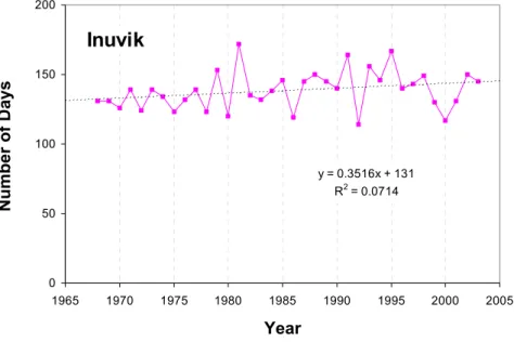
Inuvik
Figure 6: Expected Cumulative Melting Degree trendline at Inuvik projected to year 2020 based on 1968 to 2003 dataset.
y = 3.1665x - 5617.1 R2 = 0.1095 0 200 400 600 800 1000 1200 1400 1960 1970 1980 1990 2000 2010 2020 Year
Cumulative Melting Degree (°C)
Iqaluit
Figure 7: Expected Cumulative Melting Degree trendline at Iqaluit projected to year 2020 based on 1968 to 2003 dataset.
y = 5.3731x - 10263 R2 = 0.2794 0 200 400 600 800 1000 1200 1400 1600 1960 1970 1980 1990 2000 2010 2020 Year
Cumulative Melting Degree (°C)
Pond Inlet
Figure 8: Expected Cumulative Melting Degree trendline at Pond Inlet projected to year 2020 based on 1968 to 2003 dataset.
y = 0.5588x - 870.69 R2 = 0.0096 0 200 400 600 800 1000 1200 1400 1600 1960 1970 1980 1990 2000 2010 2020 Year
Cumulative Melting Degree (°C)
Resolute
Figure 9: Expected Cumulative Melting Degree trendline at Resolute projected to year 2020 based on 1968 to 2003 dataset.
y = 6.4858x - 11943 R2 = 0.1513 0 200 400 600 800 1000 1200 1400 1600 1960 1970 1980 1990 2000 2010 2020 Year
Cumulative Melting Degree (°C)
Tuktoyaktuk
Figure 10: Expected Cumulative Melting Degree trendline at Tuktoyaktuk projected to year 2020 based on 1968 to 2003 dataset.
As can be seen, there is high degree of variance in the data with three standard deviations required to cover all data points within each station. CMDs can vary between 100 to 150% from the lowest to the highest values. R2 values range from 0.0096 to 0.279 and are all very low indicating high scatter in the data. This scatter reduces confidence in carrying the trend line forward.
y = -25.363x + 50592 y = 7.5412x - 14376 y = 18.479x - 36215 y = -41.115x + 82977 0 200 400 600 800 1000 1200 1400 1600 1965 1970 1975 1980 1985 1990 1995 2000 2005 Year
Cumulative Melting Degree (°C)
Cambridge Bay
Figure 11: Cumulative melting degree trendline per decade at Cambridge Bay (years 1968–1979, 1980-1989, 1990-2000, above 2000) y = -7.4733x + 15378 y = -6.7661x + 14107 y = 25.821x - 50790 y = -29.26x + 59356 0 200 400 600 800 1000 1200 1400 1600 1965 1970 1975 1980 1985 1990 1995 2000 2005 Year
Cumulative Melting Degree (°C)
Coral Harbour
Figure 12: Cumulative melting degree trendline per decade at Coral Harbour (years 1968–1979, 1980-1989, 1990-2000, above 2000)
y = 14.501x - 27320 y = 37.883x - 73851 y = 23.228x - 44889 y = 23.655x - 46075 0 200 400 600 800 1000 1200 1400 1600 1800 2000 1965 1970 1975 1980 1985 1990 1995 2000 2005 Year
Cumulative Melting Degree (°C)
Inuvik
Figure 13: Cumulative melting degree trendline per decade at Inuvik (years 1968– 1979, 1980-1989, 1990-2000, above 2000) y = 6.8333x - 12858 y = -2.743x + 6123 y = 7.6261x - 14537 y = 20.91x - 41092 0 200 400 600 800 1000 1200 1400 1600 1965 1970 1975 1980 1985 1990 1995 2000 2005 Year
Cumulative Melting Degree (°C)
Iqaluit
Figure 14: Cumulative melting degree trendline per decade at Iqaluit (years 1968– 1979, 1980-1989, 1990-2000, above 2000)
y = -3.01x + 6270 y = 7.4915x - 14437 y = 4.2815x - 8098.1 y = -23.935x + 48399 0 200 400 600 800 1000 1200 1400 1965 1970 1975 1980 1985 1990 1995 2000 2005 Year
Cumulative Melting Degree (°C)
Pond Inlet
Figure 15: Cumulative melting degree trendline per decade at Pond Inlet (years 1972–1979, 1980-1989, 1990-2000, above 2000) y = -5.3358x + 10751 y = -0.4127x + 1063 y = 8.6479x - 16999 y = -11.39x + 23029 0 200 400 600 800 1000 1200 1400 1600 1965 1970 1975 1980 1985 1990 1995 2000 2005 Year
Cumulative Melting Degree (°C)
Resolute
Figure 16: Cumulative melting degree trendline per decade at Resolute (years 1968– 1979, 1980-1989, 1990-2000, above 2000)
y = 18.957x - 36525 y = 31.024x - 60633 y = 31.302x - 61399 y = 1.26x - 1609.5 0 200 400 600 800 1000 1200 1400 1600 1965 1970 1975 1980 1985 1990 1995 2000 2005 Year
Cumulative Melting Degree (°C)
Tuktoyaktuk
Figure 17: Cumulative melting degree trendline per decade at Tuktoyaktuk (years 1968–1979, 1980-1989, 1990-2000, above 2000)
There is variation within decades with the 1970’s being generally a decade of declining temperatures, and with the 1980’s and particularly the 1990’s being decade of rising temperatures. There is a trend, mainly in the central and high Arctic for declining CMDs during the present decade. This change to cooler temperatures is reflected in the return of the Old Ice in many areas of the high Arctic since its destruction in 1998.
The average annual CMD throughout the period between years 1968 and 2004 was calculated for the whole Arctic (represented by an average CMD of the seven met stations) and plotted in Figure 18. As can be seen, there is high interannual variability in CMD for both the individual stations and the whole Arctic. The high degree of variability from one summer to the next has important implications to marine operations in the Canadian Arctic as ice conditions encountered from one year to the next can also be highly variable. To investigate the effect this interannual variability has on the Zone/Date system for the Northwest Passage, representative “colder than normal” and “warmer than normal” summers across the control zones that compose the Northwest Passage as well as the access routes to the Port of Churchill in Hudson Strait were selected. The warmer than normal summer would also be representative of a warmer Arctic in the future in the case of a warming trend in the climate conditions. Years 1986 (cold year) and 1998 (warm year) were selected for the NWP, and years 1992 (cold year) and 1998 (warm year) for Hudson Strait.
y = 3.0176x - 5398.9 R2 = 0.1714 0.0 100.0 200.0 300.0 400.0 500.0 600.0 700.0 800.0 900.0 1965 1970 1975 1980 1985 1990 1995 2000 2005
Year
Cumulative Melting Degree (°C)
W ithout Tuk and Pond Inlet
W ithout Pond Inlet
Figure 18: Cumulative Melting Degree (CMD, calculated as Cumulative Air Temperature above 0°C) averaged over the Canadian Arctic
4.2 Length of Melting Season
The length of the melting season was calculated as the sum of days when the air temperature, at the 7 met stations, was greater than –1.8 °C. Table 4 lists the beginning, the end, and the length of the melting season for each year throughout the period between years 1968 and 2004. Statistics such as Mean, Median, Minimum and Maximum are also listed for each location in this Table. Number of days with air temperature above –1.8°C for each of the 7 met station locations are plotted in Figure 19 to Figure 25.
y = 0.004x + 110.83 R2 = 1E-05 0 50 100 150 200 1965 1970 1975 1980 1985 1990 1995 2000 2005 Year Number of Days Cambridge Bay
Figure 19: Number of days with air temperature above –1.8°C at Cambridge Bay throughout period of 1968-2003 y = -0.1613x + 120.88 R2 = 0.0191 0 50 100 150 200 1965 1970 1975 1980 1985 1990 1995 2000 2005 Year Number of Days Coral Harbour
Figure 20: Number of days with air temperature above –1.8°C at Coral Harbour throughout period of 1968-2003
y = 0.3516x + 131 R2 = 0.0714 0 50 100 150 1965 1970 1975 1980 1985 1990 1995 2000 2005 Year Number of Days Inuvik
Figure 21: Number of days with air temperature above –1.8°C at Inuvik throughout period of 1968-2003 y = 0.264x + 129.46 R2 = 0.0324 0 50 100 150 200 1965 1970 1975 1980 1985 1990 1995 2000 2005 Year Number of Days Iqaluit
Figure 22: Number of days with air temperature above –1.8°C at Iqaluit throughout period of 1968-2003
y = 0.3941x + 95.217 R2 = 0.0601 0 50 100 150 200 1965 1970 1975 1980 1985 1990 1995 2000 2005 Year Number of Days Pond Inlet
Figure 23: Number of days with air temperature above –1.8°C at Pond Inlet throughout period of 1975-2003 y = 0.1142x + 83.851 R2 = 0.0085 0 50 100 150 200 1965 1970 1975 1980 1985 1990 1995 2000 2005 Year Number of Days Resolute
Figure 24: Number of days with air temperature above –1.8°C at Resolute throughout period of 1968-2003
y = 0.3201x + 120.72 R2 = 0.0576 0 50 100 150 1965 1970 1975 1980 1985 1990 1995 2000 2005 Year Number of Days Tuktoyaktuk
Figure 25: Number of days with air temperature above –1.8°C at Tuktoyaktuk throughout period of 1974-2003
There has been very little change in the number of days with air temperature above -1.8°C calculated from daily air temperature data obtained from the 7 met stations. Some stations show a slight increase (such as in the western Arctic) while others show a slight decrease.
Table 4: Number of days with air temperature above –1.8°C at 7 locations in the Canadian Arctic (based on the air temperature data obtained from the met stations at these locations). Start and End are given in Julian Days.
Canadian Arctic
As can be seen from data of annual melting degree accumulations (Figure 3 and Figure 18) all stations show an increase in the air temperatures since the late 1960’s. However, there is a high degree of variability from one year to the next. The seasonal temperatures indicate variation of three standard deviations from the mean. At virtually every station, the highest annual accumulation of melting degrees is 100% to 150% more than the lowest value in the record. Often a below or above average year will occur in close succession. Marine operations occur during the short summer season in the Canadian Arctic. This high degree of variability from one summer to the next has important implications to marine operations in the Canadian Arctic as ice conditions encountered from one year to the next can also be highly variable. In assessing the implications of a warming climate on Arctic shipping, we must also consider the possible reasons for this interannual variability as they may be greater than the changes that may come from climate change over the next 20 to 50 years.
The length of the summer period when melting degrees are accumulated is short in the Canadian Arctic, spanning from early June to mid-September for most locations. This short time span makes the summer melting period in many areas in the Canadian Arctic very susceptible to persistent or “blocking” weather systems that may bring several weeks of cold northerly winds or warmer southerly flow in a row, contributing to the wide range of melting degree days experienced from one season to the next. A blocking weather pattern occurs when the transition of weather fronts is very slow or highly repetitive such that the same above or below normal temperature and precipitation pattern persists for several weeks or months at a time. Such blocking patterns sometimes look like the Greek letter Omega, with a strong central high pressure cell and two opposing low pressure cells on each side, also known as an “Omega Block”. Another common blocking pattern is a “Rex Block” when two or more strong high and low pressure cells lock in a succession creating an “S” pattern of frontal boundaries.
On the surface these blocking systems appear to be a product of short term “weather” patterns and are not associated with longer term climate change. However, there are elements of the climate of North America that contribute to the creation of these blocking patterns. The juxtaposition of cold ice masses in the Arctic Ocean and Greenland with the warm ocean waters of the North Atlantic and North Pacific create three significant weather systems that affect the climate of North America. These are the “Aleutian Low” pressure cell found in the Bering Sea, the “Polar High” pressure cell found over the Arctic Ocean (and associated “Greenland High”) and the “Icelandic Low” found in the North Atlantic south of Greenland-Iceland. The pattern of weather systems that move around these features in essence create an inverted Omega Block for the North American Arctic and the relative intensity of each of these low and high pressure cells in any given summer will often determine whether cooler or warmer than normal air is able to penetrate into various regions of the North American Arctic over the brief summer melt period.
To investigate whether there are any patterns associated with cooler or normal summers, the melting degree (MD) records for each station and the years when the five lowest and five highest accumulated MDs were recorded for each station were reviewed. The results of this analysis are shown in Figure 26 and Figure 27.
0 1 2 3 4 5 6 7 8 1972 1974 1976 1978 1980 1982 1984 1986 1988 1990 1992 1994 1996 1998 2000 2002 Year Number of Stations
Figure 26: Number of Stations Reporting 5 Highest Cumulative Melting Degrees
0 1 2 3 4 5 6 7 8 1972 1974 1976 1978 1980 1982 1984 1986 1988 1990 1992 1994 1996 1998 2000 2002 Year Number of Stations
be reported by more than one station in any given summer, indicating that such trends are regional across a broad area of the Arctic rather than just in a local area. It can also be seen that cooler summers have tended to occur much more commonly in the 1970’s and 1980’s than in the 90’s or in recent years and, conversely, there is a tendency for warmer summers in the 1990’s. Such a trend is to be expected when a data record such as this is showing a steady increase in average summer temperatures over the period. Since several stations across the Arctic tend to report similar temperature trends over the data record, it is possible that there are larger global climate patterns at work that influence summer Arctic temperatures in any given year, including changes to the interaction between the Aleutian and Icelandic lows compared to the Polar High.
There is much discussion in the literature on the existence of the Arctic Oscillation (AO) and the influence this has on the climate of the Arctic region (Dickson et al 2000). It is generally agreed that the Arctic Oscillation is in fact part of the North Atlantic Oscillation (NAO) (Dickson et al 2000). The AO/NAO essentially refers to the difference in atmospheric pressure between the Polar High, the Icelandic Low and the Azores High, found west of Portugal. When the pressure differences are higher than the historical mean between these systems (i.e. when the gradient between the Polar and Azores high is steep compared to the Icelandic Low) then the AO/NAO is considered to be in a “positive” state and when the gradient is below the historical average the AO/NAO is considered to be in a “negative” state (that is, a weak Icelandic Low). During a strong positive AO/NAO the Icelandic Low is very strong, drawing down cold Arctic air along the Canadian East Coast and bringing warm moist air into Western Europe. Conversely, when the AO/NAO is negative, the Icelandic Low is weak keeping Polar air to the north and allowing warm air into eastern North America but cooler and drier air into Western Europe. The AO/NAO has its greatest influence during the winter months when the pressure gradient between the low and high pressure systems at its greatest. A study of ice conditions in the Gulf of St. Lawrence has found a close association between positive AO/NAO years and heavy winter ice conditions in the Gulf and, conversely, lighter ice conditions during negative AO/NAO conditions (Gorman 2000). This influence on regional weather is so strong that the British Met Office uses the AO/NAO indices as the basis for its long range weather forecast (Rodwell and Folland 2002).
There are no known studies available on the degree to which the AO/NAO influences weather or ice conditions in the Canadian Arctic. Figure 28 presents the AO/NAO pattern since 1950 as calculated by the British Met Office (the blue predicted line in the figure represents the test of skill of the British Met Office prediction system). The AO/NAO went through a long negative period during the 1960’s and has trended towards positive since. Significant points along the observed curve include the trough of the negative cycle reached in 1969 followed by a positive period in the early to mid 1970’s with the decade ending in a negative cycle. During the decade of the 1980’s the AO/NAO generally trended upwards once again with a peak in 1989 and staying positive through most of the 1990’s with the exception of 1996. The OA/NAO has trended near neutral in recent years.
Figure 28: AO/NAO pattern since 1950 as calculated by British Met Office
If the years where three or more stations reported the highest MD accumulations are selected from our database, the years 1975, 1989, 1995 and 1998 stand out from the record. Figure 28 shows that in all four cases the AO/NAO was in a positive phase during these years. With a strong Icelandic Low, more warm air is able to penetrate into the Arctic pushing back the Polar High. If we do the same for years in our database with a least three or more stations reporting the lowest MD accumulations, the following years come to light; 1972, 1976, 1978, 1986, and 1992. The association with the AO/NAO is much less clear in these cases as it was positive for 1972, 1976 and 1992 but negative for 1978, 1979, 1986 and 1996. In recent years the AO/NAO has trended towards neutral and this has corresponded to less variability in summer Arctic temperatures since 2000. It should be noted that the AO/NAO has its strongest influence in the winter months so the dates listed in Figure 28 represent the winter that preceded the summer of that year. An association can be made that positive AO/NAO’s tend to produce warm summers in the Canadian Arctic and negative AO/NAO’s produce cool summers, but this is a very weak association. The British Met Office data that was used to produce the figure above was based primarily on the analysis of the pressure difference between the Icelandic Low and the Azores Low. There may be an influence of the AO/NAO on summer conditions in the Arctic but this requires a much more detailed investigation involving a computation that includes the Polar High gradient. Such an analysis is well outside the scope of this present study.
Oscillation (ENSO). ENSO refers to the cyclic pattern relating to the appearance of warmer than normal equatorial Pacific Ocean surface waters west of South America (the El Niño condition) or cooler than normal waters in the region (the La Niña condition). It is well documented that ENSO cycles have a significant effect on weather conditions experienced over North America.
During El Niño years the Polar Jet Stream that traverses North America splits in two, with a southern branch running across the southern United States and a northern branch running northward along the west coast of North America then plunging southward across the central and eastern portion of the continent. The consequence of this pattern is that western, central and south-eastern North America are placed into the sub-tropical air mass during an El Niño winter, creating much warmer and wetter conditions than usual. This means that Alaska and the Great Lakes should experience favourably warm weather conditions during an El Niño year. The Aleutian Low strengthens to dominate Alaska pushing back the Polar High and bringing warm air into the region. However, north-eastern North America, particularly the Labrador Coast, Hudson Strait and the north-eastern Arctic should experience colder to much colder than normal conditions. Figure 29 and Figure 30 map the temperature deviation over Canada during the previous El Niño winters of 1982/83 (Figure 29) and a strong El Niño in 1991/92 (Figure 30). It is quite clear, particularly from an analysis of Figure 30, that El Niño conditions provide for cold falls and winters to the eastern Canadian Arctic.
Figure 29: Temperature Deviation over Canada during the El Niño winter of 1982/83
Figure 30: Temperature Deviation over Canada during the El Niño winter of 1991/92
However, during La Niña conditions, the situation is somewhat reversed. During La Niña winters, the intensity of the Polar Jet Stream increases and moves south to parallel the Canada/U.S. border. This brings colder, drier air into central North America providing colder winters over most of the continent.
Alaska suffers particularly colder than normal conditions during La Niñas, as does most of central North America and the Great Lakes. The Aleutian Low weakens allowing the Polar High to dominate over Alaska. However, the return air flow from the La Niña pattern actually provides warmer conditions into the eastern Canadian Arctic, although this air flow is rather weak. Therefore, La Niña conditions are more likely to provide milder and more favourable conditions to the Labrador Coast, Hudson Strait and the eastern Canadian Arctic. Alaska and the Beaufort Sea, however, will likely experience much worst than normal conditions in the fall of a La Niña year.
Given this general theory of how the ENSO behaves over North America, it can be looked at when El Niño and La Niña conditions have occurred and compare them to our database of summer Arctic Cumulative Melting Degrees (CMD). The years when El Niño and La Niña occurred concurrent with our data record are as follows:
El Niño years:
1970/71, 1973/74, 1975/76, 1985/86, 1987/88, 1995/96, 1999/2000
If we again look at our database of years where three or more stations reported the highest MD accumulations, we see that 1975, 1989, 1995 and 1998 stand out while our coolest years in the record are 1972, 1976, 1978, 1979, 1986, 1992 and 1996. Attempting to find a correlation of these years to ENSO events is a very complex problem as ENSO events are a gradual shifting phenomenon that can span one or more years. A detailed investigation of the ENSO relationship to Canadian Arctic summer temperatures is well beyond the scope of this present work but there are some observations that can be made. The 1973 to 1976 La Niña was one of the strongest and longest lasting cool ENSO periods on record and contributed to extremely cold summers and heavy ice conditions in Alaska and the Beaufort Sea. In fact, the summer of 1975 was the worst on record for ice condition in the Beaufort Sea with the pack ice not clearing off the North Slope of Alaska all summer. In contrast, the strongest El Niño of 1997/98 contributed to the most extensive clearing in the Beaufort Sea. It is well understood that ice conditions in Alaska and the Beaufort Sea are strongly influenced by ENSO events. However, the relationship with Canadian Arctic ice conditions is less clear and it is possible that the ENSO and AO/NAO interact in a complex relationship that can only be identified with a rigorous analysis. For example, the 1997/98 El Niño led to the warmest year on record for all of Canada, including the Canadian Arctic that experienced the lightest ice conditions on record. This occurred during both a strong El Niño and moderate positive AO/NAO event and may have been related to these concurrent phenomenon.
The conclusion from this brief analysis is that the highly variable conditions seen in the Canadian Arctic temperatures may well be related to AO/NAO and ENSO events and that further research into this is warranted. This is particularly true in light of the fact that the AO/NAO and ENSO are the subject of ongoing investigations as to the role they play in climate change and finding a relationship between these phenomena and the Canadian Arctic would be an important link to understanding the implications of climate change on the region.
6. Methodology
As part of this project a new methodology was developed to analyze the impact of climate change and/or seasonal temperature variation on the veracity of the Zones and Dates used in the ZDS. The study focuses on the portion of the Canadian Arctic that covers the Northwest Passage as well as the access to the port of Churchill through Hudson Strait. The analysis examines the existing and potential changes to ice regimes in the Northwest Passage (NWP) and Hudson Strait shipping lanes due to the climate change. The length of the shipping season for colder than normal and warmer than normal summers is analyzed for each Zone by both the ZDS and the AIRSS. Both systems are then compared.
6.1 Data processing
Two sets of trajectories were defined. The first set of trajectories was defined as line segments approximately 125.5 km (Table 5). The trajectories in Zone 4 and Zone 12, Zone 11 and Zone 7, Zone 6 and Zone 13, and Zone 13 and Zone 9 were defined to assess how much the two neighboring Zones differ. The trajectories were also defined in Zone 14 and Zone 15. The route segments are shown in Figure 31.
Table 5: Length and locations of the first set
LOCATION LENGTH (km) ZONE CAMBIDGE_BAY 125.002 ZONE 11 CAMBIDGE_BAY 125.187 ZONE 7 CORAL_HARBOUR 125.248 ZONE 14 IQALUIT 125.057 ZONE 15 POND_INLET 125.834 ZONE 13 POND_INLET 125.834 ZONE 9 RESOLUTE 125.124 ZONE 13 RESOLUTE 124.826 ZONE 6 TUKTOYAKTUK 125.539 ZONE 12 TUKTOYAKTUK 126.003 ZONE 4
The second set of trajectories consisted of actual navigation routes through the Northwest Passage, and through the approach to and across Hudson Bay (Figure 2). The Hudson Bay trajectory was defined with a Main route and an Alternative Route. These two routes are identical through the approach, but split east of Coats Island. The Alternative route curves northward around Coats Island, and the Main route curves Southward around Coats Island. The routes meet again at Churchill. These lines (trajectories) were buffered into 1 km wide polygons using ArcView GIS software. The trajectories have associated
trajectory (NWP East, NWP West, Hudson Strait, Hudson Bay Main route, Hudson Bay Alternate Route) and the Zone number. Digital Regional weekly ice charts issued by Canadian Ice Service (CIS) were also imported into ArcView and intersected with the trajectory maps (layers). The resulting layers’ data attribute table contains attributes from both maps. Detailed description of data processing can be found in Appendix A.
Figure 31: Route Segments in the Northwest Passage and in Hudson Strait
6.2 Data Analysis
It should be noted that the route remained fixed over all years of the analysis and no attempt was made to adjust the route to avoid ice. Such adjustment would have increased the complexity and difficulty of the analysis. In any case, the use of ice information and appropriate route planning is not a requirement of the Zone/Date component of ASPPR. Figure 32 shows an example of the route crossing six different ice regimes in one Zone (Zone11). The Ice Numerals (IN) for Type B ice class vessel were calculated for each ice regime the shipping route crossed based on the ice information obtained from the egg code.
Figure 32: Northwest Passage route crossing six different ice regimes within Zone 11 The INs calculated throughout the whole year were compared to the Entry and Exit dates of the appropriate Zone. The ASPPR Type B ice class vessel was selected since this is the lowest ice class vessel allowed passage through all Control Zones that compose the Northwest Passage (Zones 12, 11, 7, 6, and 13). Table 6 shows Entry and Exit dates for Type B vessel as per the Zone/Date System. Zones 1, 2 and 5 do not allow access to Type B vessels, but since these Zones may also fall into the route plan of a vessel crossing the Northwest Passage they were analyzed as well. The IN calculations are based on the ice charts, which do not indicate ridging or decay, so neither ridging nor decay is reflected in the IN values. Satellite images were used to analyze and explain the ice movement and any peculiarities in results, for example a sudden drop in the IN value. Table 6: Zone/Date Table for Type B vessel (Entry and Exit dates)
Zone No. 1 2 3 4 5 6 7 8 9 10 11 12 13 14 15 16 Entry Date - - Aug 20 Aug 20 - Aug 25 Aug 10 Aug 10 Aug 10 Aug 1 July 15 July 1 July 15 July 1 July 1 June 20 Exit Date Sept 5 Sept 15 Sept 30 Oct 15 Oct 31 Oct 31 Oct 31 Oct 20 Oct 25 Oct 15 Nov 30 Nov 30 Nov 10
An example of analysis in comparing the two systems is shown in Figure 33 to Figure 36. Figure 33 and Figure 34 show the range of Ice Numerals in Zone 11 for cold and warm years, respectively. The circles represent the Ice Numerals calculated from the CIS ice charts. The Regional ice charts for the Canadian Arctic are issued monthly in the winter/spring season and weekly in the summer/fall season. The lowest values of Ice Numerals and the highest values of Ice Numerals are connected by a line to highlight the range of Ice Numerals throughout the whole year. In some instances the values of Ice Numerals are superimposed; therefore a number indicating a count of Ice Numerals at that particular value was printed on the circle. Circles without numbers represent a single
shipping season for Type B vessel in Zone 11 (July 15 to October 20). 2 2 2 3 2 3 2 4 3 2 2 2 3 2 3 2 2 2 2 2 2 4 2 2 2 2 -40 -30 -20 -10 0 10 20 30 40 Ice Numeral ZONE DATE IN
JAN. FEB. MAR. APR. MAY JUN. JUL. AUG. SEP. OCT. NOV. DEC. RANGE OF ICE NUMERALS
NORTHWEST PASSAGE - ZONE 11 1986 (COLD YEAR)
Highest IN
Lowest IN
Figure 33: Range of Ice Numerals calculated from CIS ice charts for NWP shipping route in Zone 11, throughout year 1986 (colder than normal in period 1968-2004)
2 3 2 2 3 2 2 2 2 2 2 2 2 2 3 2 2 2 2 -40 -30 -20 -10 0 10 20 30 40 Ice Numeral ZONE DATE IN
JAN. FEB. MAR. APR. MAY JUN. JUL. AUG. SEP. OCT. NOV. DEC. RANGE OF ICE NUMERALS
NORTHWEST PASSAGE - ZONE 11 1998 (WARM YEAR)
Highest IN
Lowest IN
Figure 34: Range of Ice Numerals Calculated from CIS ice charts for NWP shipping route in Zone 11, throughout year 1998 (warmer than normal in period 1968-2004) The sudden drop in the value of the IN in Figure 33 (cold year 1986) is due to the high concentrations of Thick First-Year ice in eastern Amundsen Gulf. Coronation Gulf was still fast with Thick First-Year ice.
Data shown in Figure 33 and Figure 34 are further analyzed in Figure 35 and Figure 36, respectively. These Figures (Figure 35 and Figure 36) show a count of negative and positive Ice Numerals for cold and warm years, respectively. The purpose of this plot is


![[PDF] Introduction à la programmation en Visual Basic](data:image/gif;base64,R0lGODlhAQABAIAAAP///wAAACH5BAEAAAAALAAAAAABAAEAAAICRAEAOw==)