Publisher’s version / Version de l'éditeur:
Vous avez des questions? Nous pouvons vous aider. Pour communiquer directement avec un auteur, consultez la première page de la revue dans laquelle son article a été publié afin de trouver ses coordonnées. Si vous n’arrivez pas à les repérer, communiquez avec nous à [email protected].
Questions? Contact the NRC Publications Archive team at
[email protected]. If you wish to email the authors directly, please see the first page of the publication for their contact information.
https://publications-cnrc.canada.ca/fra/droits
L’accès à ce site Web et l’utilisation de son contenu sont assujettis aux conditions présentées dans le site LISEZ CES CONDITIONS ATTENTIVEMENT AVANT D’UTILISER CE SITE WEB.
Laval Virtual: 9th Virtual Reality International Conference (VRIC'2007)
[Proceedings], 2007
READ THESE TERMS AND CONDITIONS CAREFULLY BEFORE USING THIS WEBSITE. https://nrc-publications.canada.ca/eng/copyright
NRC Publications Archive Record / Notice des Archives des publications du CNRC :
https://nrc-publications.canada.ca/eng/view/object/?id=36d9661f-b256-4811-8965-a6c2b0a9e75c https://publications-cnrc.canada.ca/fra/voir/objet/?id=36d9661f-b256-4811-8965-a6c2b0a9e75c
NRC Publications Archive
Archives des publications du CNRC
This publication could be one of several versions: author’s original, accepted manuscript or the publisher’s version. / La version de cette publication peut être l’une des suivantes : la version prépublication de l’auteur, la version acceptée du manuscrit ou la version de l’éditeur.
Access and use of this website and the material on it are subject to the Terms and Conditions set forth at
Virtual urban design
National Research Council Canada Institute for Information Technology Conseil national de recherches Canada Institut de technologie de l'information
Virtual Urban Design *
Ceconello, M, Paquet, E.
April 2007
* published at VRIC’2007 - Laval Virtual - 9th Virtual Reality International Conference. April 18-22, 2007. Laval, France. NRC 49279. ISBN 2-9515730-6-5, 177-183 (2007).
Copyright 2007 by
National Research Council of Canada
Permission is granted to quote short excerpts and to reproduce figures and tables from this report, provided that the source of such material is fully acknowledged.
Virtual Urban Design
M. Ceconelloa and E. Paquetb
a
Dipartimento INDACO – Industrial Design, Art & Communication, Politecnico di Milano, via Durando 10, 20158, Milano, Italy – [email protected]
b
Visual Information Technology, Institute for Information Technology, National Research Council, M-50 Montreal Road, Ottawa, Ontario, K1A 0R6, Canada – [email protected]
Key words: 3-D, content-based, indexing, retrieval, urban design, urban planning, virtual
Abstract:
The application of virtual reality to cultural heritage, environment, and landscape planning is extremely useful to experiment various scenarios which could not be necessarily realised in the real world; both for educational and research purposes. The aim of this paper is to demonstrate how 3D representations can be utilised as a valid support for urban planners and designers in order to verify beforehand a variety of interventions or modifications for a particular area, and to establish the best strategy in order for the later to be reclaimed and re-qualified.
I. Introduction
For years, the application of 3D modelling to territorial representation as well as to the inter-connected field of events simulation has been an active field of investigation. With the introduction of software packages for automatic design, numerical models are increasingly replacing or at the very least complementing physical and studio models.
A numerical model created by extrusion in the information system can be exported in VRML format which, in addition of being a standard for exchanging models over the Internet, can be easily converted to various formats which can be exported into a multitude of connected software packages.
The ultimate modelling phase in such a modelling process is the so-called ‘detail’ phase which aims to reproduce realistically the object both from the shape and appearance point of view. A greater level of detail can be achieved with the digitalisation, in three-dimensions, of whole sections of buildings with a laser scanner or a time of flight system. From the cloud of points generated by the scanner, it is possible to fusion the various views, to extract the original topology and to create a realistic and accurate model of the original. The definition of the digital model can also be improved with the help of photogrammetric techniques and digital photographs. Digital models, apart from their photorealism, are able to act as true virtual prototypes endowed with behavioural
and performance similarities. They allow us to observe, simulate and analyse the design project, as well as its behaviour, in a much better way than physical models, both from the visualization and a database point of view. The further shift from the hyper-realistic model to the virtual reality system enables the planner to appraise the planning decisions in relation to the urban re-organization, including new modes of intervention in the pre-existing urban landscape.
The requirements of the virtual environments are analyzed from a conceptual and technical point of view. Among them are: photorealism, scalability (both from the virtual scene and the virtual theatre size points of view), intellectual property protection (for collaborative work), and content-based information retrieval (for database access). The architecture and the implementation of the mobile virtual environment are described; the later being grid-based.
A content-based approach is adopted for information retrieval and algorithms have been developed for the indexing and retrieval of both 3D objects and 2D images based on their 3D shape and composition respectively. Such a visual approach to information retrieval is intuitive and follows a semantic typical of art and architecture without any invasive interface since the object under consideration acts as its own interface. The present is applied to the evaluation of the impact of the re-design of a square in the historical centre of the city of Milan in Italy.
II.
Visualisation of Virtual Urban
Designs
II.1 Urban Landscape
The correct representation of “land” has turned out to be of fundamental importance when the design aspect of new planning projects has to be divulged and made “visible”, not only to government officials, engineers and administrators, but to city-dwellers alike. The plans that are drawn, not to mention the technical and thematic documentations prevent large sectors of the public, which are not familiar with such an information representation, from fully appreciating the situation. The 1980s saw the introduction of systems that employ a series of instruments representing and illustrating design projects as well as new urban initiatives. Those were required in order to help the general public to better understand the “technical” aspect of the situation with a range of instrumentation ranging from plastic and digital models to geographic information systems equipped with multi-media applications; not to forget the internet, of course [1].
Starting from analytical schemes like the ones proposed by Lynch [2], we have been able to re-create and utilize such concepts for the study, the planning and the modification of urban spaces such that the “best possible form” can be obtained [3]. Such subject matter has been improved and utilised in other research projects by employing virtual technologies. The later have been able to plan and spread the message that the design project intended to create.
Since the city and the land upon which the city lies form a reality that is difficult to describe (and, above all, to represent) an efficient analysis of the whole situation is nonetheless mandatory. This enables us to understand in a fully comprehensible way all the characteristics, features and choices that might arise during any sort of structural intervention.
The city possesses numerous pieces of information that are either descriptive or visual. In the first case, the widespread use of territorial information systems - GIS has made the management of the data related to the various features that make up the area of land considerably easier. In the second case, the use of digital models is a powerful instrument of representation and a valid form of help that enables people to see and appreciate both the current state as well as the hypothetical modifications even before the latter come into reality. Furthermore, it allows for the correct evaluation of outcomes and effects before a real intervention effectively occurs.
This is even clearer in the case of territorial representation for which the level of detail (which is the
fundamental guarantee of the 3D GIS simulations) adds an irreplaceable merit to design projects [4, 5]. Indeed, it is an instrument which is of the utmost efficiency since, a part from representing a particular environment; it enables us to freely navigate as well as to observe features of interest from a variety of viewpoints. For instance, just consider how useful such a representation is for landscape planners and architects when they evaluate the progress of a certain phenomenon or when they evaluate the impact of an urban intervention upon the surrounding environment [6]. Therefore, its indispensability can be best understood when a high level of detail and a total level of adherence to reality are mandatory. Moreover, this hyper-realistic model allows us to reach further and get to the very construction of virtual environments [7, 8]. Of course, these are environments which do not actually exist in reality… II.2 Digital Models for Urban Planning
The use of 3D models has been for years the object of investigation in the field of territorial representation as well as the inter-connected field of event simulation. With the introduction of programmes for automatic design, the usage of numerical models has attempted to replace their physical and studio homologues [9]. Consequently, the use of simulators that are more or less automatic has tried to create the right conditions to generate urban environments. Nevertheless, these programmes, based upon pre-defined libraries, find it hard to adapt to the morphological features of most Italian and European cities. Many Italian cities like Florence, Milan or Rome call for detailed and well-articulated models with particular characteristics that cannot easily be standardized.
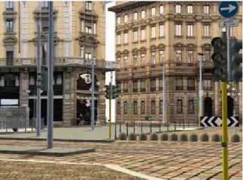
Figure 1. Visualisation of Piazza Cordusio in Milano; model with textures rendered with the virtual theatre.
That means that volume extrusion models must be enriched with details and particular features which make them more similar to their real counterpart. This operation has been made possible by the creation of maps and facades of buildings (as well as photographs) which
have been chosen for such experimental purpose. The photographs are used to create the necessary texture to apply to the models, a part from being particularly helpful in the definition of size and construction details. The last outcome in the modelling phase – the so-called “detail” phase – is, therefore, a digital object which reproduces its own corresponding figure in reality both in form as well as in appearance. Although the various steps have been subjected to a methodological approach, the time involved in each one of them should be taken into account as well. Indeed, in order for the research to be fully carried out, it is absolutely essential to evaluate the feasibility of the process as a whole as well as to revise the process step by step in order for the later to be as rigorous and scientific as possible.
A greater level of definition can be achieved by using 3D laser scanning systems which enable the acquisition of whole portions of buildings as clouds of points which can be later modelled into forms. Technological processes like the aforementioned, in addition to digital photogrammetry systems [10] have been extensively used at the Virtual Prototyping and Reverse Modelling Laboratory at the Polytechnic of Milan and they have enabled us to perfect the definition of digital models, as required. However, at this point, we have to underline the importance of exactly defining the scope and the level of detail which are deemed necessary for our modelling. Indeed, since the models are simplifications and schematizations of reality, there is always a gap between reality and the level of detail in the actual model. If the level of detail is not sufficient, we run the risk of losing the main interactions and so the model will turn out to be incomprehensible and useless. On the contrary, if the level of detail is excessive, the model will become much too complicated and will end up being just as indecipherable as in the previous case. Therefore, the definition of the level of detail is one of the most important planning steps that have to be undertaken when these models are utilised.
The fundamental characteristic of digital models, apart from the photo-realistic simulation of reality, is that they are able to act as true virtual prototypes endowed with behavioural and performance similarities. They make us observe, simulate and analyse the design project (as well as its behaviour) in a much better way than offered by similar technologies, both from visualization and database point of view.
The further shift from the hyper-realistic model to the systems of virtual reality enables the planner to validate the planning decisions in relation to urban re-organization (including new forms of intervention in the pre-existing urban landscape) by using sophisticated equipments and the aid of stereoscopic visualisation [11]. The models created in the previous phase are imported in suitable software that has been studied for the digital
visualization of re-constructed environments on a large screen in a virtual theatre. At this stage, an interactive real-time navigation through the virtual re-construction clearly indicates all the potential problems that a planning operation may bring about in any particular urban area while offering the best type of solution in the most suitable context. It is easy to visualize the different proposals in their natural sequence and to single out the most appropriate. A further merit stems from the fact that results and planning activities are now provided for the benefit of a non-specialized public. In addition, because the outcome can be export in many formats, a variety of packages and applications can be utilised and link; for instance with GIS databases.
II.3 Architecture of the System
In this section, we describe a cost-effective approach for the stereo visualisation of virtual sites. When a site is virtualised, it is possible to make it available to a large variety of people, as far as the intellectual property protection allows.
Figure 2. Visualisation system setup with laptops and DLP video-projectors.
While most users are content to visualise a site with a standard computer, specialists and architects are not. Most of the time, architects need access to high quality pictures of sites. Despite the fact that the pictures provide a high-resolution representation of the visual appearance of the site, they provide limited and ambiguous information about the three-dimensional shape. Furthermore, the pictures are taken from a very limited subset of viewpoints, which are not necessarily the ones required by the architect.
Most commercial stereo systems suffer either from high-cost or from poor performances. In both cases, the access to the data is limited: in the first case, because a small number of users can afford the system, while in the second case, the system can only display low-resolution versions of the original data. For these reasons, we have created a cost-effective stereo visualisation system suitable for the visualisation of large amount of complex three-dimensional data. The system is made of off-the-shelf components and is characterised by its scalability, its distributed architecture and its portability. Let us review its architecture.
The system (Fig.1) is formed of two interconnected laptops and two DLP video projectors. The first computer, the sender, receives the events from the user and renders the right-eye view. The second computer, the receiver, is synchronised with the sender and renders the left-eye view. Each computer is attached to an ultra-compact DLP video projector. The left and right-eye views are simultaneously projected though polarised filters on a special screen that maintains polarisation. The polarisation is circular right for the right-eye view and circular left for the left-eye view. The circular polarisation insures that the orientation of the user’s head does not introduce cross talk in between the right and the left view, which would deteriorate the stereo effect. The scene can be visualised in three dimensions with the corresponding passive stereo glasses.
The software is written in Java/Java 3-D and the same byte code can run transparently on OpenGL and DirectX. The synchronization is ensured as follows. Before it renders a frame, the sender updates its navigation parameters from the events generated by the user. It sends the navigation parameters through a firewire to the receiver, which renders the left-eye view of the scene. Meanwhile, the sender renders the right-eye view of the scene. Then the sender sends a synchronisation signal to the receiver and both computers swap their respective buffer. In order to obtain a higher resolution, an arbitrary number of receivers can be connected to the sender. Thus, it is possible to render a scene at ultra-high resolution by simply adding more computers and projectors: each computer-projector pair being responsible for the rendering of a subset of the scene; the so-called tiled wall display.
Currently, the system runs on Dell Precision M60 laptops with a NVIDIA® Quadro FX Go700™ 4XAGP graphics card with 128 MB of texture memory. The selected DLP video projectors are the NEC LT260K: their brightness is 2100 ANSI lumens and their native resolution is 1024 x 768. These projectors have a proprietary technology that corrects rapidly and efficiently the horizontal and vertical keystones, which make the alignment relatively straightforward even in the case of multiple displays. The selected polarised filters are the 3M HNCP37. They have been chosen because their light transmission curve is relativity uniform over a wide range of visual
wavelengths, which means that the colour distortion is reduced to a minimum. This is an important aspect to ensure the faithfulness toward the original.
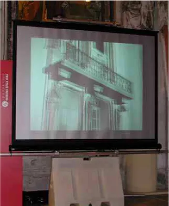
Figure 3. Visualisation of a portion of the Sala delle Cariatidi in Palazzo Reale a Milano. Partial view of the
restored model with an added balcony.
II.4 Experimental Results
In order to verify the aforementioned process, we have decided to create a model of Piazza Cordusio which is situated in the historical centre of Milan. This place derives its name - Curtis Ducis - from the Longobard period and was the seat of the court for Longobard Duke. The piazza, which can be found in the financial district, presents and elliptical shape. The piazza acts as a pedestrian area in between the Castle and the Duomo. The basic idea was to use the virtual reconstruction in order to evaluate the re-design of the site without doing drastic intervention by trying to understand if colour could help to improve the appearance and the perception of the site. Elements such as traffic lights, benches, lampposts, just to mention a few, can generate visual noise. For this reason, a purposive sampling of all the objects and a study of the colour map of the area was carried out.
Starting from digital cartography, the model was created while adding more accurate information from drawings and plans of the buildings. In order to add details on the façades, a lot of pictures were acquired with a digital camera in order to help for instance, to better define balconies, ornaments, and complex shapes. While creating the model, it was decided not to use laser scanners and photogrammetric techniques because, at that
stage of the project, the focus was to validate the whole process from the urban planner point of view, without excluding the use of more accurate and sophisticated methods once its applicability has been verified and demonstrated. As a matter of fact, a research group from the Politecnico di Milano has already utilised laser scanners and photogrammetric techniques in order to acquire monuments and buildings for various projects. For instance, members of the group1 have created a partial digital model of the Sala delle Cariatidi (Caryatids Room) in Palazzo Reale (Royal Palace) in Milan in order to evaluate the impact of a possible restoration and to decide the best mode of intervention. The results were presented at a Conference held in Palazzo Reale; the model (Fig.2) was converted and imported into the portable version of the Teatro Virtuale2 (virtual theatre). Once the urban scene has been loaded into the virtual environment created by the National Research Council of Canada, the user is able to navigate into the scene while visualizing the three-dimensional elements in stereo. By simply pressing a key, various scenarios can be studied such that the best proposal can be identified.
Since the models are in the VRML format, they can be easily exported into other applications for complementary results. Finally, the textured models were integrated in the municipality GIS. In the present case, the GIS integration was completed with the ArcGis 9.1 environment. By following this approach, it is possible, in the long run, to create a digital model of the entire city.
III.
An Integrated Approach to
Virtual Urban Designs
Management
Since urban design involves the management of complex projects, it becomes important to manage the data efficiently. In the case of virtual urban design, most of the data are images and 3D objects.
In order to achieve this objective, we present an integrated approach to virtual urban designs management. The proposed approach consists of five steps: virtualisation, documentation, indexation, retrieval, characterisation and finally, visualisation; we just outline the approach here; technical details can be found in [12]. The first step is well known and thousands of scientific papers have been devoted to the subject. Although virtualisation is and will remain a major research area, it is our opinion that documentation has been neglected. Most architects assume that virtualised models are conformed to the original ones within the precision of the
1
Research group: Gaiani M. (coordinator), Brevi. F, Ceccarelli N., Crisciani C., Magrassi G., Micoli L., Russo M., Pignatel A., Manganiello A., Penati. A..
2
Research group: Ceconello M., Paquet E., Peters S.
apparatus utilised to virtualize them. It has been shown that although a model might be precise, it is not necessarily accurate [13]. Precision is related to the reproducibility of the measured data while accuracy is related to the conformity of the measured data with the original model. It is difficult in an extra-laboratory situation to determine if the measured data are accurate or not. Unfortunately, this is the most common situation. For that reason, in addition to the virtualised model, additional information should be provided. The provided information should at least include, the type of apparatus utilised to virtualize the object, resolution, precision, stamped calibration, stamped raw data, time-stamped temperature and humidity, etc. The availability of such data would assist the architect to assert the validity of the measured data.
Indexation turns out to be important when the number of virtualised object becomes significant. Our aptitude to retrieve pertinent information is primarily determined by the quality of our indexes. An index can be a textual description of the object, a set of measurements, a set of keywords and metadata or, an innovative technique like composition and shape description: the so-called content-based approach. While some fields like architecture have developed a systematic procedure for indexation, one has to recognise that it is not the case for most fields. Even worst, in most cases, there is no information at all associated with the objects. A content-based approach can provide a partial solution to this problem since it automatically indexes a database. The content-based indexes provide a description of the objects in terms of composition and shape. A search engine then provides a fast and efficient access to the database. The content-based approach does not replace classical indexation but it complements it and provides an alternative if the later is absent.
Images and 3D object are of particular interest to the architects and city planners. They are (and will remain in a foreseeable future) the easiest, fastest and most economical mean for creating virtual urban designs. Furthermore, most three-dimensional models are covered with textures. The textures constitute an important visual descriptor for the model under consideration and convey essential historical, artistic and architectural information. Images are difficult to describe. They convey a large amount of complex and ambiguous information. The ambiguity is due to the fact that an image is a bidimensional projection of the three-dimensional world and by the fact that the illumination of this world is arbitrary and cannot be controlled. Because of this ambiguity and complexity, it is difficult to segment images and to understand them [14]. For the above mentioned reasons, we propose a statistical approach in which the overall composition of the image is described in an abstract manner.
As we know, an image is worth a thousand words, which means that it is difficult to describe an image based solely on words. For that reason, our retrieval approach is based on the so-called “query by example” or “query by prototype” paradigm. To this end, we created a search engine that can handle such queries. In order to initiate a query, the user provides an image or prototype to the search engine. This prototype is described or indexed and the later is compared with a metric to a database of pre-calculated indexes, which correspond to the images of the virtual database. The search engine finds the most similar images with respect to the prototype and displays them to the user. The user then acts as an expert: he chooses the most meaningful image from the results provided by a search engine and reiterates the query process from the chosen image. The process is repeated until convergence is achieved
The indexation of three-dimensional objects differs fundamentally from the indexation of images [15]. If the three-dimensional information has been acquired accurately at a sufficiently high resolution, the three-dimensional geometry constitutes an unambiguous body of information in the sense that there is a one-to-one correspondence between the virtualised geometry and the physical geometry of the object.
Shape also constitutes a language of its own right. In addition to verbal language, humanity has developed a common shape language. This is particularly evident in fields like art and architecture. For that reason, the “query by prototype” approach is a powerful paradigm for the retrieval of similar objects.
As far as the overall structural design is involved, the three-dimensional object retrieval system is very similar to its image counterpart: the objects of the database are indexed offline and a database of indexes is created. In order to interrogate this database, the query is initiated with a prototype object. From the proto-object, an index is calculated and compared with the help of a metric to the indexes of the database in order to retrieve the most similar objects in terms of three-dimensional shape. As stated before, the user can act as an expert in order to reiterate the process until convergence. Consequently, the main differentiation between the two systems (image versus 3-D) is the index.
Characterisation is intimately related to retrieval [16]. The combination of classical documentation with content-based indexes is of particular interest. Classical information can act as a filter on the database, which then can be searched with a content-based approach.
We saw that shape constitutes a universal language. This is obvious in art and architecture. Indeed, numerous styles can be characterized by the shape of their associated architectural elements. For instance, let us considerer the three classical orders of columns: Ionic,
Doric and Corinthian. Columns of the same order are of course never identical but their shape is sufficiently similar so that it is relatively straightforward to identify them. The same can be said about cupolas, Roman arcs and Gothic arcs; the list is literally endless.
While studying a database, an architect usually studies particular objects but he may as well want to compare similar objects in order to determine their common characteristics, their discrepancies or even the temporal evolution of a particular style. In order to be able to perform these actions, the architect must be able to group or cluster similar objects within a common class [17]. Our system can find, in a database, similar three-dimensional objects. By following an iterative or spiral approach, the user can converge to the item of interest. Some results in relation with this approach are reported in [18]. Once the objects of interests have been retrieved, that must be visualised. We have presented a cost-effective stereo visual system for the visualisation of complex three-dimensional objects and scenes. One of the advantages of this system is that it can be rapidly deployed on any working site and may therefore be utilised as a terrain and operational device.
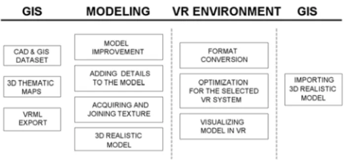
Figure 4. Research outline with different activities and the related output.
V. Conclusions
Our approach greatly facilitates the evaluation of various scenarios of urban designs with problem solving purpose such as restoration.
Our results confirm the innovative aspect of our research. With virtual prototypes, it is possible to evaluate the most relevant scenarios in real-time on a cognitive basis. As a matter of fact, the planning action needs a support either in the analysis or in the presentation of the results. Digital tools are able to replace maps and physical models merging together shape and functions, as they allow conveying the iconic description of the real entity with its analytic definition through the use of connected databases.
Virtual reality is a niche market which involves specific technical know-how, customization, dedicated hardware
and software; these reveal its expensive nature and limit its applicability to fields traditionally related to the IT sector. The originality of our approach comes from its cost effectiveness and its high usability. The hardware is standard and does not need the support of a skilled technician, the java based interface is self-explanative and intuitive, and the possibility to use a wireless joystick makes the navigation into the virtual reconstruction an easy and enjoyable experience.
Our intention is to suggest an integration of these visualization techniques in the normal practice of a planning office in a City Council. In the normal course of activities, the use of GIS supports decision making is extremely useful for managing planning tasks. Virtual reconstruction and presentation of possible intervention on the fabric of a city, gives the city manager the chance to visualize its impact. The project can be considered a test bed to verify a process in which these items could be put together in order to create a “best practice” in urban planning (Fig. 4).
The research is currently in an ongoing phase and, as we speak, this approach has been applied to the historical centre of Milan, and has been evaluated positively both by technicians and city managers employed in urban planning. From this case study, there is an opportunity to initiate more complex activities in order to evaluate various scenarios for the restoration of ancient buildings façade in the historical centre of Milan. This method has not been used with citizens, even if we think it could be very helpful as a mean for divulging and explaining all the planning activities to a non-technical audience.
VI. References
[1] Shiffer (M.J.), Towards a collaborative planning system, Environment and Planning B: Planning and Design, 19 (6), pp 709-722, 1992.
[2] Lynch (K.), The image of the City. Cambridge, MIT Press and Harvard U.P., 1960.
[3] Lynch (K.), Managing the Sense of a Region. Cambridge, MIT Press, 1976.
[4] Brail (R.), Klosterman (R.), Planning support systems: integrating geographic systems, models, and visualization tools. Redlands, Esri Press, 2001.
[5] Raper (J.), Kelk (B.), Three-dimensional GIS. In: Maguire, D.J., Goodchild, M., Rhind, D.W. Geographical information systems: principles and applications. Essex, Longman scientific and technical, pp. 299-317, 1991. [6] Dodge (M.), Doyle (S.), et al., Towards the Virtual City: VR & Internet GIS for Urban Planning, Virtual Reality and Geographical Information Systems Workshop. London, Birkbeck College May 1998.
[7] Kraak (M.J.), Smets (G.), Sidjanin (P.), Virtual reality, the new 3D interface for geographical information systems. In: Camara, A., J. Raper Spatial Multimedia and Virtual Reality. London, Taylor & Francis, pp. 130-136, 1999.
[8] Raper (J.), McCarthy (F.), Livingstone (D.), Interfacing GIS with Virtual Reality technology”, Proceedings Association for Geographic Information conference, Birmingham, 3, 25, pp. 1-4, 1993.
[9] Batty (M.), Dodge (M.), et. al., Visualising Virtual Urban Environments, CASA Working Paper 1. London: Centre for Advanced Spatial Analysis, University College London, 1998.
[10] Guidi (G.), Beraldin (J.A.), Acquisizione 3D e modellazione poligonale. Dall'oggetto fisico alla suo calco digitale. Milano, Polidesign, 2004.
[11] Ceconello (M.) Strumenti e tecniche di visualizzazione. In: Gaiani, M. Metodi di prototipazione digitale e visualizzazione per il disegno industriale, l’architettura degli interni e i beni culturali. Milano, Polidesign, 2003.
[12] E. Paquet, C. Lahanier, D. Pitzalis, S. Peters, G. Aitken and H. L. Viktor, “Content-based Indexing and Retrieval of Cultural Heritage Data: an Integrated Approach to Documentation with Application to the EROS Database”, The 7th International Symposium on Virtual Reality, Archeology and Cultural Heritage – VAST 2006, EPOCH Publication, The e-volution of Information Communication Technology in Cultural Heritage, Where Hi-Tech Touches the Past: Risks and Challenges for the 21st Century, Project papers from the joint event CIPA/VAST/EG /EuroMed 2006, 30 October - 4 November, Nicosia, Cyprus, 270-275 (2006).
[13] Guidi (G.) et al., Accuracy Verification and Enhancement in 3D Modeling: Application to Donatello’s Maddalena, Fourth International Conference on 3D Digital Imaging and Modeling, pp. 334-341, Oct. 2003.
[14] Tsekeridou (S.) and Pitas (I.), Audio-Visual Content Analysis for Content-Based Video Indexing, IEEE Multimedia Computing and Systems, 1, pp. 667-672, Jun. 1999.
[15] Paquet (E.) and Rioux (M.), Nefertiti: a query by content system for three-dimensional model and image databases management, Image and Vision Computing, 17, pp. 157-166, 1999.
[16] E. Paquet and H. L. Viktor, “Visualisation, Exploration and Characterization of Virtual Collections”, TS W/G V/6 Visualization and Animations, XXth Congress – International Society for Photogrammetry and Remote Sensing – ISPRS 2004, 12-23 July, Istanbul, Turkey, 597-602 (2004).
[17] E. Paquet, H. L. Viktor, O. Abdali and M. Rioux, “Exploring anthropometric data through cluster analysis”, SAE Digital Human Modeling for Design & Engineering – DHMC 2004, 15-17 June, Rochester (Michigan), USA, 2004-01-2187-2190 (2004).
[18] Paquet (E.) and Rioux (M.), Anthropometric Visual Data Mining: a Content-based Approach, International Ergonomics Association XVth Triennial Congress, pp. 78-91, Aug. 2003.