HAL Id: hal-01935797
https://hal.sorbonne-universite.fr/hal-01935797
Submitted on 27 Nov 2018
HAL is a multi-disciplinary open access
archive for the deposit and dissemination of
sci-entific research documents, whether they are
pub-lished or not. The documents may come from
teaching and research institutions in France or
abroad, or from public or private research centers.
L’archive ouverte pluridisciplinaire HAL, est
destinée au dépôt et à la diffusion de documents
scientifiques de niveau recherche, publiés ou non,
émanant des établissements d’enseignement et de
recherche français ou étrangers, des laboratoires
publics ou privés.
of low subsidence rate Paleozoic intracratonic basins
(Reggane, Ahnet, Mouydir and Illizi basins, Hoggar
Massif)
Paul Perron, Michel Guiraud, Emmanuelle Vennin, Isabelle Moretti, Eric
Portier, Laetitia Le Pourhiet, Moussa Konaté
To cite this version:
Paul Perron, Michel Guiraud, Emmanuelle Vennin, Isabelle Moretti, Eric Portier, et al.. Influence
of basement heterogeneity on the architecture of low subsidence rate Paleozoic intracratonic basins
(Reggane, Ahnet, Mouydir and Illizi basins, Hoggar Massif). Solid Earth, European Geosciences
Union, 2018, 9 (6), pp.1239 - 1275. �10.5194/se-9-1239-2018�. �hal-01935797�
https://doi.org/10.5194/se-9-1239-2018
© Author(s) 2018. This work is distributed under the Creative Commons Attribution 4.0 License.
Influence of basement heterogeneity on the architecture of low
subsidence rate Paleozoic intracratonic basins (Reggane, Ahnet,
Mouydir and Illizi basins, Hoggar Massif)
Paul Perron1, Michel Guiraud1, Emmanuelle Vennin1, Isabelle Moretti2, Éric Portier3, Laetitia Le Pourhiet4, and Moussa Konaté5
1Université de Bourgogne Franche-Comté, Centre des Sciences de la Terre, UMR CNRS 6282 Biogéosciences,
6 Bd Gabriel, 21000 Dijon, France
2ENGIE SA, 1, place Samuel de Champlain, Faubourg de l’Arche, 92930 Paris La Défense, France 3Neptune Energy International S.A., 9-11 Allée de l’Arche – Tour EGEE – 92400 Courbevoie, France
4Sorbonne Université, CNRS-INSU, Institut des Sciences de la Terre Paris, ISTeP UMR 7193, 75005 Paris, France 5Département de Géologie, Université Abdou Moumouni de Niamey, BP:10662, Niamey, Niger
Correspondence: Paul Perron (paul.perron@u-bourgogne.fr, paul.perron@hotmail.fr) Received: 30 May 2018 – Discussion started: 27 June 2018
Revised: 28 September 2018 – Accepted: 4 October 2018 – Published: 7 November 2018
Abstract. The Paleozoic intracratonic North African Plat-form is characterized by an association of arches (ridges, domes, swells, or paleo-highs) and low subsidence rate syn-cline basins of different wavelengths (75–620 km). The Reg-gane, Ahnet, Mouydir and Illizi basins are successively de-limited from east to west by the Amguid El Biod, Arak-Foum Belrem, and Azzel Matti arches. Through the anal-ysis of new unpublished geological data (i.e., satellite im-ages, well logs, seismic lines), the deposits associated with these arches and syncline basins exhibit thickness varia-tions and facies changes ranging from continental to ma-rine environments. The arches are characterized by thin amalgamated deposits with condensed and erosional sur-faces, whereas the syncline basins exhibit thicker and well-preserved successions. In addition, the vertical facies suc-cession evolves from thin Silurian to Givetian deposits into thick Upper Devonian sediments. Synsedimentary struc-tures and major unconformities are related to several tec-tonic events such as the Cambrian–Ordovician extension, the Ordovician–Silurian glacial rebound, the Silurian–Devonian “Caledonian” extension/compression, the late Devonian ex-tension/compression, and the “Hercynian” compression. Lo-cally, deformation is characterized by near-vertical planar normal faults responsible for horst and graben structuring associated with folding during the Cambrian–Ordovician–
Silurian period. These structures may have been inverted or reactivated during the Devonian (i.e., Caledonian, Mid– Late Devonian) compression and the Carboniferous (i.e., pre-Hercynian to pre-Hercynian). Additionally, basement character-ization from geological and geophysics data (aeromagnetic and gravity maps), shows an interesting age-dependent zona-tion of the terranes which are bounded by mega-shear zones within the arches–basins framework. The “old” terranes are situated under arches while the “young” terranes are located under the basins depocenter. This structural framework re-sults from the accretion of Archean and Proterozoic terranes inherited from former orogeny (e.g., Pan-African orogeny 900–520 Ma). Therefore, the sedimentary infilling pattern and the nature of deformation result from the repeated slow Paleozoic reactivation of Precambrian terranes bounded by subvertical lithospheric fault systems. Alternating periods of tectonic quiescence and low-rate subsidence acceleration as-sociated with extension and local inversion tectonics corre-spond to a succession of Paleozoic geodynamic events (i.e., far-field orogenic belt, glaciation).
1 Introduction
Paleozoic deposits fill numerous intracratonic basins, which may also be referred to as “cratonic basins”, “interior cra-tonic basins”, or “intracontinental sags”. Intracracra-tonic basins are widespread around the world (Heine et al., 2008) and ex-ploration for nonconventional petroleum has revived interest in them. They are located in “stable” lithospheric areas and share several common features (Allen and Armitage, 2011). Their geometries are large circular, elliptical, and/or saucer-shaped to oval. Their stratigraphy is filled with continental to shallow-water sediments. Their subsidence rate is low (5 to 50 m Ma−1) and long (sometimes more than 540 Myr). Their structural framework shows the reactivation of struc-tures and emergence of arches also referred to in the litera-ture as “ridges”, “paleo-highs”, “domes”, and “swells”. Mul-tiple hypotheses and models have been proposed to explain how these slowly subsiding, long-lived intracratonic basins formed and evolved (see Allen and Armitage, 2011 and ref-erences therein or Hartley and Allen, 1994). However, their tectonic and sedimentary architectures are often poorly con-strained.
The main specificities of intracratonic basins are found on the Paleozoic North Saharan Platform. The sedimentary in-filling during ca. 250 Myr is relatively thin (i.e., around a few hundred to a few thousand meters), of great lateral ex-tent (i.e., 9 million km2), and is separated by major regional unconformities (Beuf et al., 1968a, 1971; Carr, 2002; Es-chard et al., 2005, 2010; Fabre, 1988, 2005; Fekirine and Ab-dallah, 1998; Guiraud et al., 2005; Kracha, 2011; Legrand, 2003a). Depositional environments were mainly continental to shallow-marine and homogeneous. Very slow and subtle lateral variations occurred over time (Beuf et al., 1971; Carr, 2002; Fabre, 1988; Guiraud et al., 2005; Legrand, 2003a). The Paleozoic North Saharan Platform is arranged (Fig. 1) into an association of long-lived broad synclines (i.e., basins or subbasins) and anticlines (i.e., arches) of different wave-lengths (λ: 75–620 km). Burov and Cloetingh (2009) report deformation wavelengths of the order of 200–600 km when the whole lithosphere is involved and of 50–100 km when the crust is decoupled from the lithospheric mantle. This in-sight suggests that the inherited basement fabric influences intracratonic basin architecture at a large scale. In addition, pre-existing structures, such as shear zones and terrane su-ture zones, are present throughout the lithosphere, affecting the geometry and evolution of upper-crustal structural frame-work forming during later tectonic events (Peace et al., 2018; Phillips et al., 2018).
In this study of the Reggane, Ahnet, Mouydir, and Il-lizi basins, a multidisciplinary workflow involving various tools (e.g., seismic profiles, satellite images) and techniques (e.g., photogeology, seismic interpretation, well correlation, geophysics, geochronology) has enabled us to (1) make a tectono-sedimentary analysis, (2) determine the spatial ar-rangement of depositional environments calibrated by
bios-tratigraphic zonation, (3) characterize basin geometry, and (4) ascertain the inherited architecture of the basement and its tectonic evolution. We propose a conceptual coupled model explaining the architecture of the intracratonic basins of the North Saharan Platform. This model highlights the role of basement heritage heterogeneities in an accreted mobile belt and their influence on the structure and evolution of intracra-tonic basins. It is a first step towards a better understanding of the factors and mechanisms that drive intracratonic basins.
2 Geological setting: the Paleozoic North Saharan Platform and the Reggane, Ahnet, Mouydir, and Illizi basins
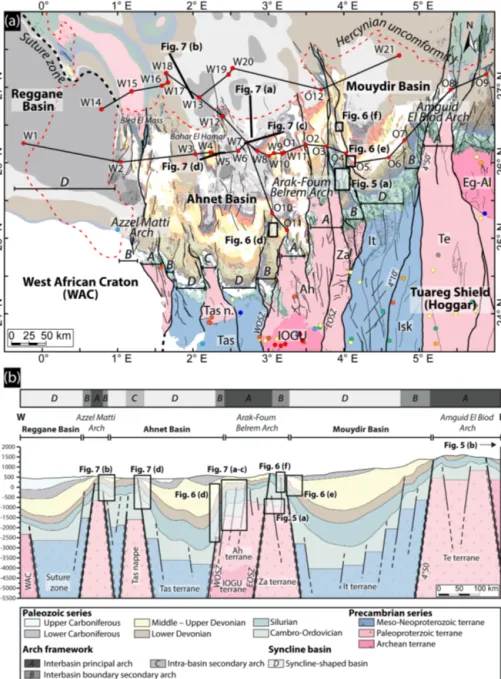
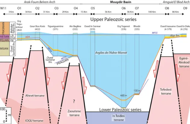
The Reggane, Ahnet, Mouydir and Illizi basins (Figs. 1 and 2) are located in southwestern Algeria, north of the Hog-gar Massif (AhagHog-gar). They are depressions filled by Pale-ozoic deposits. The basins are bounded to the south by the Hoggar Massif (Tuareg Shield) and they are separated one another by the Azzel Matti, the Arak-Foum Belrem, and the Amguid El Biod arches.
Figure 3 synthesizes the lithostratigraphy, the large-scale sequence stratigraphic framework delimited by six main re-gional unconformities (A to F), and the tectonic events pro-posed in the literature (cf. references under Fig. 3) affecting the Paleozoic North Saharan Platform.
During the Paleozoic, the Reggane, Ahnet, Mouydir and Illizi basins were part of a set of the supercontinent Gond-wana (Fig. 1). This supercontinent resulted from the colli-sion of the West African Craton (WAC) and the East Saharan Craton (ESC), which sandwiched the Tuareg Shield (TS) mo-bile belt during the Pan-African orogeny (Craig et al., 2008; Guiraud et al., 2005; Trompette, 2000). This orogenic cycle followed by the chain’s collapse (ca. 1000–525 Ma) was also marked by phases of oceanization and continentalization (ca. 900–600 Ma) giving rise to the heterogeneous terranes in the accreted mobile belt (Trompette, 2000). The Hoggar Massif is composed of several accreted, sutured, and amalgamated terranes of various ages and compositions resulting from multiple phases of geodynamic events (Bertrand and Caby, 1978; Black et al., 1994; Caby, 2003; Liégeois et al., 2003). Twenty-three well preserved terranes were identified in the Hoggar Massif and grouped into Archean, Paleoproterozoic, and Mesoproterozoic–Neoproterozoic juvenile Pan-African terranes (see legend in Fig. 1). In the West African Craton, the Reguibat Shield is composed of Archean terrains in the west and of Paleoproterozoic terranes in the east (Peucat et al., 2003, 2005).
Then, there is evidence of a complex and polyphased his-tory throughout the Paleozoic (Fig. 3), with alternating peri-ods of quiescence and tectonic activity, individualizing and rejuvenating ancient N–S, NE–SW, or NW–SE structures in arch and basin configurations (Badalini et al., 2002; Boote et al., 1998; Boudjema, 1987; Coward and Ries, 2003; Craig
Figure 1. Geological map of the Paleozoic North Saharan Platform (North Gondwana) georeferenced, compiled and modified from (1) a Paleozoic subcrop distribution below the Hercynian unconformity geology of the Saharan Platform (Boote et al., 1998; Galeazzi et al., 2010), (2) a geological map (1/500 000) of the Djado Basin (Jacquemont et al., 1959), (3) a geological map (1/200 000) of Algeria (Bennacef et al., 1974; Bensalah et al., 1971), (4) a geological map (1/50 000) of Aïr (Joulia, 1963), (5) a geological map (1/2 000 000) of Niger (Greigertt and Pougnet, 1965), (6) a geological map (1/5 000 000) of the Lower Paleozoic of the central Sahara (Beuf et al., 1971), (7) a geological map (1/1 000 000) of Morocco (Hollard et al., 1985), (8) a geological map of the Djebel Fezzan (Massa, 1988), and (9) a basement characterization of the different terranes from geochronological data compilation (see Supplement) and geological maps (Berger et al., 2014; Bertrand and Caby, 1978; Black et al., 1994; Caby, 2003; Fezaa et al., 2010; Liégeois et al., 1994, 2003, 2005, 2013). Terrane names and abbreviations: Tassendjanet (Tas), Tassendjanet nappe (Tas n.), Ahnet (Ah), In Ouzzal Granulitic Unit (IOGU), Iforas Granulitic Unit (UGI), Kidal (Ki), Timétrine (Tim), Tilemsi (Til), Tirek (Tir), In Zaouatene (Za), In Teidini (It), Iskel (Isk), Tefedest (Te), Laouni (La), Azrou-n-Fad (Az), Egéré-Aleskod (Eg-Al), Serouenout (Se), Tazat (Ta), Issalane (Is), Assodé (As), Barghot (Ba), Tchilit (Tch), Aouzegueur (Ao), Edembo (Ed), and Djanet (Dj). Shear zone and lineament names and abbreviations: suture zone East Saharan Craton (SZ ESC), west Ouzzal shear zone (WOSZ), east Ouzzal shear zone (EOSZ), Raghane shear zone (RSZ), Tin Amali shear zone (TASZ), 4◦100shear zone, 4◦500shear zone, and 8◦300shear zone.
Figure 2. (a) Geological map of the Paleozoic of the Reggane, Ahnet, and Mouydir basins. For the legend and references see Fig. 1. (b) An E–W cross section of the Reggane, Ahnet, and Mouydir basins associated with the different terranes and highlighting the classification of the different structural units. Localization of the interpreted sections (seismic profiles and satellite images). W represents well and O represents outcrop. See Fig. 1 for location of the geological map A and cross section B.
et al., 2008; Guiraud et al., 2005; Logan and Duddy, 1998; Lüning, 2005). The Paleozoic successions of the North Sa-haran Platform are predominantly composed of siliciclastic detrital sediments (Beuf et al., 1971; Eschard et al., 2005). They form the largest area of detrital sediments ever found on continental crust (Burke et al., 2003), dipping gently NNW (Beuf et al., 1971, 1969; Fabre, 1988, 2005; Fröhlich et al., 2010; Gariel et al., 1968; Le Heron et al., 2009). Carbonate deposits are observed from the Middle–Late Devonian to the Carboniferous (Wendt, 1985, 1988, 1995; Wendt et al., 1993, 1997, 2006, 2009a; Wendt and Kaufmann, 1998). From south
to north, the facies progressively evolve from continental flu-viatile to shallow marine (i.e., upper to lower shoreface) and then to offshore facies (Beuf et al., 1971; Carr, 2002; Es-chard et al., 2005; Fabre, 1988; Fekirine and Abdallah, 1998; Legrand, 1967a).
3 Data and methods
A multidisciplinary approach was used in this study integrat-ing new data (i.e., satellite images, seismic lines and
well-Figure 3. Paleozoic litho-stratigraphic, sequence stratigraphy, and tectonic framework of the north peri-Hoggar basins (North African Sa-haran Platform) compiled from (1) a chronostratigraphic chart (Ogg et al., 2016), (2) the Cambrian–Silurian (Askri et al., 1995) and the Devonian–Carboniferous stratigraphy of the Reggane Basin (Cózar et al., 2016; Lubeseder, 2005; Lubeseder et al., 2010; Magloire, 1967; Wendt et al., 2006), (3) the Cambrian–Silurian (Paris, 1990; Wendt et al., 2006) and the Devonian–Carboniferous stratigraphy of the Ahnet Basin (Beuf et al., 1971; Conrad, 1973, 1984; Legrand-Blain, 1985; Wendt et al., 2006, 2009a), (4) the Cambrian–Silurian (Askri et al., 1995; Paris, 1990; Videt et al., 2010) and the Devonian–Carboniferous stratigraphy of the Mouydir Basin (Askri et al., 1995; Beuf et al., 1971; Conrad, 1973, 1984; Wendt et al., 2006, 2009a), (5) the Cambrian–Silurian (Eschard et al., 2005; Fekirine and Abdallah, 1998; Jardiné and Yapaudjian, 1968; Videt et al., 2010) and the Devonian–Carboniferous stratigraphy of the Illizi Basin (Eschard et al., 2005; Fekirine and Abdallah, 1998; Jardiné and Yapaudjian, 1968), (6) the Cambrian–Silurian (Dubois, 1961; Dubois and Mazelet, 1964; Eschard et al., 2005; Henniche, 2002; Videt et al., 2010) and the Devonian–Carboniferous stratigraphy of the Tassili-N-Ajjers (Dubois et al., 1967; Eschard et al., 2005; Henniche, 2002; Wendt et al., 2009a), (7) the sequence stratigraphy of the Saharan Platform (Carr, 2002; Eschard et al., 2005; Fekirine and Abdallah, 1998), (8) a eustatic and climatic chart (Haq and Schutter, 2008; Scotese et al., 1999), and (9) tectonic events (Boud-jema, 1987; Coward and Ries, 2003; Craig et al., 2008; Guiraud et al., 2005; Lüning, 2005). (A) Infra-Tassilian (Pan-African) unconformity, (B) intra-Arenig unconformity, (C) Taconic and glacial unconformity, (D) isostatic rebound unconformity, (E) Caledonian unconformity, and (F) Hercynian unconformity.
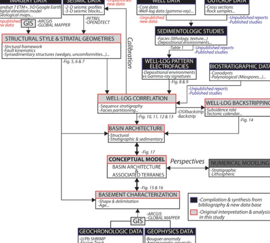
Figure 4. Schematic synthesis of the integrated method of basin analysis in this study.
logs data) in particular from the Reggane, Ahnet, Mouydir, and Illizi basins and the Hoggar Massif (Fig. 4).
The Paleozoic series of the Ahnet and Mouydir basins are well-exposed over an area of approximately 170 000 km2 and are well observed in satellite images (Google Earth and Landsat from USGS). Furthermore, a significant geologi-cal database (i.e., wells, seismic records, geologigeologi-cal reports) has been compiled in the course of petroleum exploration since the 1950s. The sedimentological dataset is based on the integration and analysis of cores, outcrops, well logs, and of lithological and biostratigraphic data. They were syn-thesized from internal SONATRACH (Dokka, 1999), IFP-SONATRACH consortium reports (Eschard et al., 1999), and published articles (Beuf et al., 1971; Biju-Duval et al., 1968; Wendt et al., 2006). Facies described from cores and outcrops of these studies were grouped into facies associations cor-responding to the main depositional environments observed on the Saharan Platform (Table 1). Characteristic gamma-ray (GR) patterns (electrofacies) are proposed to illustrate the different facies associations. The gamma-ray peaks are commonly interpreted as the maximum flooding surfaces (MFS) (e.g., Catuneanu et al., 2009; Galloway, 1989; Mil-ton et al., 1990; Serra and Serra, 2003). Time calibration
of well logs is based on palynomorphs (essentially Chiti-nozoans and spores) and outcrops on conodonts, goniatites, and brachiopods (Wendt et al., 2006). Palynological data of wells (W1, W7, W12, W19 and W20) from internal un-published data (Abdesselam-Rouighi, 1991; Azzoune, 1999; Hassan, 1984; Khiar, 1974) are based on biozonations from Magloire (1967) and Boumendjel et al. (1988). Well W18 is supported by palynological data and biozonations from Ker-mandji et al. (2008).
Synsedimentary extensional and compressional markers are characterized in this structural framework based on the analyses of satellite images (Figs. 5 and 6), seismic pro-files (Fig. 7), 21 wells (W1 to W21), and 12 outcrop cross sections (O1 to O12). Wells and outcrop sections are ar-ranged into three E–W sections (Figs. 10, 11 and 12) and one N–S section (Fig. 13). Satellite images (Figs. 5 and 6) and seismic profiles (Fig. 7) are located at key areas (i.e., near arches) illustrating the relevant structures (Fig. 2). The calibration of the key stratigraphic horizon on seismic pro-files (Fig. 7) was settled by sonic well-log data using Pe-trel and OpendTect software. Nine key horizons easily ex-tendable at the regional scale are identified and essentially correspond to major depositional unconformities: near top
T able 1. Synthesis of facies associations (AF1 to AF5), depositional en vironments, and electrof acies in the De v onian series compiled from internal (Eschard et al., 1999) and published studies (Beuf et al., 1971; Biju-Duv al et al., 1968; W endt et al., 2006). Criteria & characteristics F ormations Depos itional en vironments F acies asso-ciations T extures/lithology Sedimentary structures Biotic/non-biotic grains Ichnof acies AF1 Conglom erates, mid to coarse sandstones, silt-stones, shales T rough cross-bedding, mud clasts, lag deposits, fluidal and o v erturn structures, imbricated grains, lentic-ular laminations, oblique stratifica-tion Rare oolitic intercalations, im-bricated pebbles, sandstones, ironstones, phosphorites, corroded quartz grains, calcareous matrix, brachiopod coquinas, phos phatized pebbles, hematite, azurite, quartz Rare bioturbation Oued Samene Fm., Barre Supérieur , Barre Mo yenne Fluvial Continental (fluvial) AF2 Silt to ar gillaceous fine sandstone Current ripples, climbing ripples, cre v asse splay , root traces, pale-osols, plant debris Nodules, ferruginous horizon Oued Samene Fm., Barre Supérieur , Barre Mo yenne Flood plain AF3a Fine to coarse sandstones, ar gillaceous siltstones, shales (heterolithic) T rough cross-bedding, some planar bedding, flaser bedding, mud clasts, mud drapes, root trace, desiccation cracks, w ater escape, w avy bed-ding, shale pebble, sigmoidal cross-bedding Brachiopods, trilobites, tentacul ites graptolites Bioturbation, Sk olithos (Sk), Planolites , (Pl) Oued Samene Fm., Grès du Khenig, Barre Supérieur , Barre Mo yenne Delta/estuarine channels Coastal Plain
(transitional ma- rine/continental)
AF3b V ery coar se-grained poorly sorted sandstone T rough cross-bedding, sigmoidal cross-bedding, ab undant mud clasts and mud drapes Increasing upw ard bio-turbation Sk olithos (Sk) Oued Samene Fm., Grès du Khenig, Barre Supérieur , Barre Mo yenne Fluvial/tidal dis-trib utary channels AF3c Fine-gr ained to v ery coarse-grained het-erolithic sandstone Sigmoidal cross-bedding with mul-tidirectional tidal b undles, w avy , lenticular , flaser bed-ding, occasional current and oscilla-tion ripples, occasional mud cracks Intense bioturbation, Sk olithos (Sk), Plano -lites , (Pl), Thalassi -noides (Th) T alus à T igillites T idal sand flat AF3d Mudst ones, v aricolored shales, thin sandstone layers Occasional w av e ripples, mud cracks, horizontal lamination, rare multidirectional ripples Absence of ammonoids, goniat ites, calymenids, pelec ypod molds, bra-chiopods coquinas Intense bioturbation, Sk olithos (Sk), Plano -lites , (Pl), Thalassi -noides (Th) Oued Samene Fm., Grès du Khenig, Ataf aitaf a Fm. Lagoon/mudflat AF4a Silt y mudstone associated with coarse to v ery coarse ar gillaceous sandstone, poorly sorted, heterolithic silty mudstone Sigmoidal cross-bedding, ab undant mud clasts, w avy , lenticular cross-bedding and flaser bedding, ab un-dant current and oscillation ripples, mud drapes Shell debris (crinoids, brachiopods) Strongly bioturbated Sk olithos (Sk), Plano-lites , (Pl) Oued Samene Fm., T alus à T igillites Subtidal Shoref ace AF4b Fine-to mid-grained sandstones interbedded with ar gillaceous siltstone and mudstone, bioclastic carbonates sandstones, bro wnish sandstones and clays, silts Oscillation ripples, sw ale y cross-bedding, bidirectional bedding, flaser bedding, rare hummock y cross-bedding, mud cracks (syneresis), con v olute bedding, w avy bedding, combined flo w ripples, planar cross lo w angle stratifica-tion, cross-bedding, ripple marks, centimetric bedding, shale pebbles Ooids, crinoids, bryozoans, coral clasts, fossil debris, st romato-poroids, tab ulates, colonial rugose corals, myriad pelagic styliol inids, neritic tentaculitids, brachiopods, iron ooliths, ab undant micas Sk olithos (Sk), Cruziana , Planolites , (Pl) Chon -drites (Ch), T eic hic hnus (T e), Spir ophytons (Sp) Ataf aitaf a Fm., Zone de passage, Grès de Mehden Y ahia, Calcaires d’Azzel Matti Open marine– upper shoref ace
T able 1. Continued. Criteria & characteristics F ormations Depositional en vironments F acies asso-ciations T extures/lithology Sedimentary structures Biotic/non-biotic grains Ichnof acies AF4c Silt y shales to fine sand-stones (heterolithic) Hummock y cross-bedding, planar bedding, combined flo w ripples, con v olute bedding, dish structures, mud drapes, remnant ripples, flat lenses, slumping Intense bioturbation, Cruziana Thalassinoides (Th), Planolites (Pl), Sk olithos (Sk), Diplocr aterion (Dipl), T eic hic hnus (T e), Chondrites (Ch), Ro g er ella (Ro), Climac-tic hnites (Cl) Ataf aitaf a Fm., Zone de passage, Grès de Mehden Y ahia, Calcaires d’Azzel Matti Lo wer shoref ace AF5a Gre y sil ty-shales, b undles of sk eletal w ack estones, silty greenish shale in-terlayers fine grained sandstones, calcareous mudstones, black shales, polychrome clays (black, bro wn, gre y, green, red, pink), gre y and reddish shales Lenticular sandstones, rare hum-mock y cross-bedding, mud mounds, mud b uildups, lo w-angle cross-bedding, tempestite bedding, slump-ing, deep groo v e marks Intensi v e b urro wing, bi v alv e debris, horizontal b urro ws, sk eletal re mains (goniatites, orthoconic, nautiloids, styliolinids, trilobites, crinoids, soli-tary rugose, corals), limestones nod-ules, ironstone nodules and lay-ers Zoophycos (Z), T eic hic h-nus (T e), Planolites (Pl) Ar giles à Grapto-lites, Orsine Fm., Ar giles de Mehden Y ahia, Ar giles de T emertasset Upper of fshore Of fshore AF5b Blac k silty-shales (mud-stones), bituminous mudstones–w ack estones, packstones Rare structures P arallel-aligned styliolinids, goni-taties, orthoconic nautiloids, pelagic pelec ypod Buc hiola , anoxic condi-tions, limestone nodules, goniat ites, Buc hiola , tentaculitids , ostracods and rare fish remains, T ornocer as , A ulatornocer as , Lobotornocer as , Manticocer as , Costamanticocer as and V ir ginocer as , graptolites Zoophycos (Z) Ar giles à Grapto-lites, Orsine Fm., Ar giles de Mehden Y ahia, Ar giles de T emertasset Lo wer of fshore
infra-Cambrian, near top Ordovician, near top Silurian, near top Pragian, near top Givetian, near top mid-Frasnian, near top Famennian, near base Quaternary and near Hercynian unconformities (Fig. 7). The stratigraphic layers are identi-fied by the integration of satellite images (Google Earth and Landsat USGS: https://earthexplorer.usgs.gov/, last access: 29 November 2016), digital elevation models (DEM), and the 1 : 200 000 geological maps of Algeria (Bennacef et al., 1974; Bensalah et al., 1971).
Subsidence analysis characterizes the vertical displace-ments of a given sedimentary depositional surface by track-ing its subsidence and uplift history (Van Hinte, 1978). The resulting curve details the total subsidence history for a given stratigraphic column (Allen and Allen, 2005; Van Hinte, 1978). Backstripping is also used to restore the ini-tial thicknesses of a sedimentary column (Allen and Allen, 2005; Angevine et al., 1990). Lithologies and paleobathyme-tries have been defined using facies analysis or literature data. Porosity and the compaction proxy are based on ex-perimental data from (Sclater and Christie, 1980). In this study, subsidence analyses were performed on sections using OSXBackstrip software performing 1D Airy backstripping (following Allen and Allen, 2005; Watts, 2001); available at: http://www.ux.uis.no/nestor/work/programs.html, last ac-cess: 5 January 2017).
The 800 km2 outcrop of basement rocks of the Hog-gar Massif provides an exceptional case study of an ex-humed mobile belt composed of accreted terranes of dif-ferent ages. To reconstruct the nature of the basement, a terrane map (Figs. 15 and 16) was put together by inte-grating geophysical data (aeromagnetic anomaly map: https: //www.geomag.us/, last access: 1 December 2016, Bouguer gravity anomaly map: http://bgi.omp.obs-mip.fr/, last ac-cess: 1 December 2016), satellite images (7ETM+ from Landsat USGS: https://earthexplorer.usgs.gov/, last access: 29 November 2016) data, geological maps (Berger et al., 2014; Bertrand and Caby, 1978; Black et al., 1994; Caby, 2003; Fezaa et al., 2010; Liégeois et al., 1994, 2003, 2005, 2013), and geochronological data (e.g., U/Pb radiochronol-ogy, see Supplement data 1). Geochronological data from published studies were compiled and georeferenced (Fig. 1). Thermo-tectonic ages were grouped into eight main thermo-orogenic events (Fig. 1): The Liberian-Ouzzalian event (Arcehan, > 2500 Ma), the Archean, Eburnean (i.e., Paleo-proterozoic, 2500–1600 Ma), the Kibarian (i.e., Mesospro-terozoic, 1600–1100 Ma), the Neoproterozoic oceanization-rifting (1100–750 Ma), the syn-Pan-African orogeny (i.e., Neoproterozoic, 750–541 Ma), the post-Pan-African (i.e., Neoproterozoic, 541–443 Ma), the Caledonian orogeny (i.e., Siluro-Devonian, 443–358 Ma), and the Hercynian orogeny (i.e., Carbo-Permian, 358–252 Ma).
4 Structural framework and tectono-sedimentary structure analyses
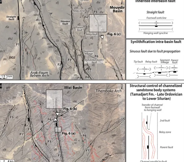
The structural architecture of the North Saharan Platform is characterized by mostly circular to oval shaped basins structured by major faults frequently associated with broad asymmetrical folds displayed by three main trends (Fig. 1): (1) near-N–S, varying from 0 to 10 or 160◦N , (2) from 40 to 60◦N , and from (3) 100 to 140◦N (Figs. 1, 3a, and 4). These fault zones are about 100 km (e.g., faults F1 and F2, Fig. 5) to tens of kilometers long (e.g., faults F3 to F8, Fig. 5). They correspond to the mainly N–S Azzel-Matti, Arak-Foum Bel-rem, Amguid El Biod, and Tihemboka arches, the NE–SW Bou Bernous, Ahara, and Gargaf arches, and the NW–SE Saoura and Azzene arches (Fig. 1).
4.1 Synsedimentary extensional markers
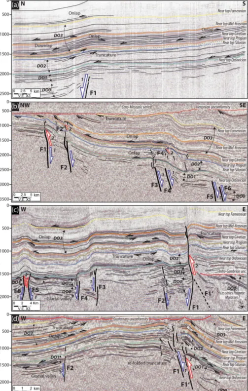
Extensional markers are characterized by the settlement of steeply westward or eastward-dipping basement normal faults associated with colinear syndepositional folds of sev-eral kilometers in length (e.g., Figs. 6a to e and 7a), rep-resented by footwall anticline and hanging wall syncline-shaped forced folds. They are located in the vicinity of differ-ent arches (Fig. 2) such as the Tihemboka Arch (Figs. 5b and 6a, b), Arak-Foum Belrem Arch (Figs. 5a, 6c to f and 7a, c), Azzel Matti Arch (Fig. 7b), and Bahar El Hamar area intra-basin arch (Fig. 7d). These tectonic structures can be featured by basement blind faults (e.g., fault F1 in Fig. 7a). The defor-mation pattern is mainly characterized by brittle faulting in Cambrian–Ordovician series down to the basement and fault-damping in Silurian series (e.g., faults F1 to F6 in Fig. 7b). The other terms of the series (i.e., Silurian to Carbonifer-ous) are usually affected by folding except (see F1 faults in Figs. 6d, 7b, d, and c) where the brittle deformation can be propagated to the Upper Devonian (due to reactivation and/or inversion as suggested in the next paragraph).
In association with the extensional markers, thickness variations and tilted divergent onlaps of the sedimentary se-ries (i.e., wedge-shaped units, progressive unconformities) in the hanging wall syncline of the fault escarpments are ob-served (Figs. 6 and 7). These are attested using photogeolog-ical analysis of satellite images (Fig. 6) and are marked by a gentler dip angle of the stratification planes away from the fault plane (i.e., fault core zone). The markers of syndeposi-tional deformation structures are visible in the hanging-wall synclines of Precambrian to Upper Devonian series (Figs. 6 and 7).
The footwall anticline and hanging-wall syncline-shaped forced folds recognized in this study are very similar to those described in the literature by Grasemann et al. (2005), Khalil and McClay (2002), Schlische (1995), Stearns (1978), With-jack et al. (1990, 2002), and WithWith-jack and Callaway (2000). The wedge-shaped units (DO0 to DO3; Figs. 5, 6, and 7) as-sociated with the hanging-wall synclines are interpreted as
Figure 5. (a) Typology of different types of faults (inherited straight faults vs. sinuous short synlithification propagation faults) in the Cambrian–Ordovician series of the Djebel Settaf (Arak-Foum Belrem Arch; interbasin boundary secondary arch between the Ahnet and Mouydir basins). (b) Structural control of channelized sandstone bodies in Late Ordovician series of South Adrar Assaouatene, Tassili-N-Ajjers (Tihemboka interbasin boundary secondary arch between the Illizi and Murzuq basins). The dotted red line represents Tamadjert Fm. channelized sandstone bodies. The abbreviations used in the figure are as follows: OTh – In Tahouite Fm. (Early to Late Ordovician, Floian to Katian); OTj – Tamadjert Fm. (Late Ordovician, Hirnantian); sIm – Imirhou Fm. (Early Silurian); sdAs1 – Asedjrad Fm. 1 (Late Silurian to Early Devonian); dAs2 – Asedjrad Fm. 2 (Early Devonian, Lochkovian); dSa – Oued Samene Fm. (Lower Devonian, Pragian). See Fig. 2 for map and cross-section location.
synsedimentary normal fault-related folding. The whole tec-tonic framework forms broad extensional horsts and grabens related to synsedimentary forced folds controlling basin shape and sedimentation.
Following Khalil and McClay (2002), Lewis et al. (2015), Shaw et al. (2005), and Withjack et al. (1990), we use the ages of the growth strata (i.e., wedge-shaped units) to deter-mine the timing of the deformation. The main four wedge-shaped units identified (DO0 to DO3) are indicative of the ac-tivation and/or reacac-tivation of the normal faults (extensional settings) during the Neoproterozoic (DO0), the Cambrian– Ordovician (DO1), the Early to Mid-Silurian (DO2), and the Middle to Late Devonian (DO3) times.
In planar view, straight (F1 in Fig. 5a) and sinuous faults (F2, F3, F3’, F4, F4’, and F5 in Fig. 5a) can be identified.
The sinuous faults are arranged “en echelon” into several segments with relay ramps. These faults are ten to several tens of kilometers long with vertical throws of hundreds of meters that fade rapidly toward the fault tips. The sinuous geometry of normal undulated faults as well as the rapid lat-eral variation in fault throw are controlled by the propagation and the linkage of growing parent and tip synsedimentary normal faults (Marchal et al., 2003, 1998). We use the strati-graphic age of impacted layers (here Tamadjert Fm.) to date (re)activation of the faults.
According to Holbrook and Schumm (1999), river patterns are extremely sensitive to tectonic structure activity. Here we find that the synsedimentary activity of the extensional struc-tures is also evidenced by the influence of the fault scarp on the distribution and orientation of sinuous channelized
sand-Figure 6. (a) Normal fault (F2) associated with a footwall anticline and a hanging wall syncline with divergent onlaps (i.e., wedge-shaped unit DO1) in the Early to Late Ordovician In Tahouite series (Tassili-N-Ajjers, Tihemboka interbasin boundary secondary arch between the Illizi and Murzuq basins). (b) Ancient normal fault (F2) escarpment reactivated and sealed during Silurian deposition (poly-historic paleo-reliefs) linked to thickness variation, divergent onlaps (DO2) in the hanging wall synclines, and onlaps on the fold hinge anticline (Tassili-N-Ajjers, Tihemboka interbasin boundary secondary arch between the Illizi and Murzuq basins). 1: Early to Late Ordovician extension, 2: Late Ordovician to Early Silurian extension, and 3: Middle to Late Silurian sealing (horizontal drape). (c) Normal fault (F5) associated with forced fold with divergent strata (syncline-shaped hanging wall syncline and associated wedge-shaped unit DO2) and truncation in the Silurian–Devonian series of Dejbel Settaf (Arak-Foum Belrem Arch; interbasin boundary secondary arch between the Mouydir and Ahnet basins). 1: Cambrian–Ordovician extension and 2: Silurian–Devonian extensional reactivation (Caledonian extension). (d) Blind basement normal fault (F1) associated with forced fold with in the hanging wall syncline divergent onlaps of the Lower to Upper Devonian series (wedge-shaped unit DO3) and intra-Emsian truncation (Arak-Foum Belrem Arch; interbasin boundary secondary arch between the Mouydir and Ahnet basins). (e) N170◦normal blind faults F1 and F2 forming a horst and graben system associated with a forced fold with Lower to Upper Devonian series divergent onlaps (wedge-shaped unit DO3) and intra-Emsian truncation in the hanging-wall syncline (in the Mouydir Basin near Arak-Foum Belrem Arch, eastward interbasin boundary secondary arch). (f) Inherited normal fault (F1) transported from footwall to hanging wall associated with an inverse fault (F1’) and accommodated by a detachment layer in the Silurian shales series (thickness variation of Imirhou Fm. between the footwall and hanging wall) and spilled dip strata markers of overturned folding (Djebel Idjerane, Arak-Foum Belrem Arch, eastwards interbasin boundary secondary arch). 1: Cambrian–Ordovician extension and 2: Middle to Late Devonian compression. The abbreviations used in the figure are as follows: OTh – In Tahouite Fm. (Early to Late Ordovician, Floian to Katian); OTj – Tamadjert Fm (Late Ordovician, Hirnantian); sIm – Imirhou Fm. (Early to Mid-Silurian); sdAt – Atafaïtafa Fm. (Middle Silurian); dTi – Tifernine Fm. (Middle Silurian); sdAs1 – Asedjrad Fm. 1 (Late Silurian to Early Devonian); dAs2 – Asedjrad Fm. 2 (Early Devonian, Lochkovian); dSa: Oued Samene Fm. (Early Devonian, Pragian); diag: Oued Samene shaly-sandstones Fm. (Early Devonian, Emsian?); d2b– Givetian; d3a – Mehden Yahia Fm. (Late Devonian, Frasnian); d3b – Mehden Yahia Fm. (Late Devonian, Famennian); dh – Khenig sandstones (late Famennian to early Tournaisian); hTn2 – late Tournaisian; hV1 – early Visean. The red line represents unconformity. See Figs. 1, 2, and 5 for map and cross-section location.
Figure 7. (a) N–S interpreted seismic profile in the Ahnet Basin near Erg Tegunentour (near Arak-Foum Belrem Arch, westward interbasin boundary secondary arch) showing steeply dipping northward basement normal blind faults associated with forced folding. (b) NW–SE interpreted seismic profile of near Azzel Matti Arch (interbasin principal arch) showing steeply dipping southeastward basement normal blind faults associated with forced folds. The westernmost structures are featured by reverse fault related propagation fold. (c) W–E in-terpreted profile of the Ahnet Basin (Arak-Foum Belrem Arch, westward interbasin boundary secondary arch) showing horst and graben structures influencing Paleozoic tectonics associated with forced folds. (d) W–E interpreted seismic profile of Bahar el Hammar in the Ahnet Basin (Ahnet intra-basin secondary arch) showing steeply dipping normal faults F1 and F2 forming a positively inverted horst as-sociated with folding. Multiple activation and inversion of normal faults are correlated with divergent onlaps (wedge-shaped units): DO0 infra-Cambrian extension, DO1 Cambrian–Ordovician extension, DO2 Silurian extension with local Silurian–Devonian positive inversion, and DO3 Frasnian–Famennian extension–local compression. See Fig. 2 for map and cross-section location.
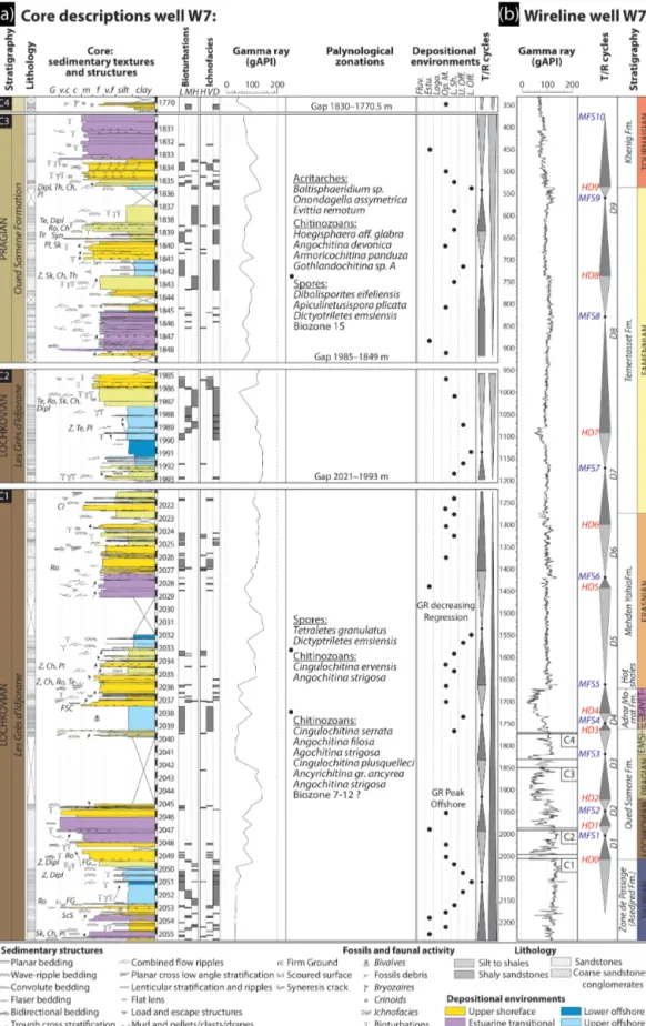
Figure 8. (a) Core description, palynological calibration, and gamma-ray signatures of well W7 modified from an internal core description report (Dokka, 1999) and an internal palynological report (Azzoune, 1999). (b) Devonian sequential stratigraphy of well-log W7. For the location of well W7 see Fig. 2a.
stone body systems (dotted red lines in Fig. 5b). It highlights the (re)activation of the faults during the deposition of these channels, i.e., Late Hirnantian dated by (Girard et al., 2012). 4.2 Synsedimentary compressional markers (inversion
tectonics)
After the development of the extensional tectonism described previously, evidence of synsedimentary compressional mark-ers can be identified. These markmark-ers are located and preferen-tially observable near the Arak-Foum Belrem Arch (Fig. 6f; F2 in Fig. 7c), the Azzel Matti Arch (2 in Fig. 7v), and the Bahar El Hamar area intra-basin arch (2 in Fig. 7d). The tec-tonic structures take the form of inverse faulting reactivating former basement faults (F1’ in Fig. 6f, F1 in Fig. 7c, F1’ in Fig. 7d, F1 in Fig. 7b). The synsedimentary inverse faulting is demonstrated by the characterization of asymmetric an-ticlines and is especially observable in satellite images and restricted to the fault footwalls (Fig. 5a along F1–F2).
Landsat image analysis combined with the line drawing of certain seismic lines reveals several thickness variations reflecting divergent onlaps (i.e., wedge-shaped units) which are restricted to the hanging-wall asymmetric anticlines (2 in Figs. 6f, 7b, c and d). The compressional synsedimen-tary markers clearly post-date extensional divergent onlaps at hanging-wall syncline-shaped forced folds (1 in Figs. 7c, c and d). This architecture is very similar to classical positive inversion structures of former inherited normal faults (Bel-lahsen and Daniel, 2005; Bonini et al., 2012; Buchanan and McClay, 1991; Ustaszewski et al., 2005). Tectonic transport from the paleo-graben hanging wall toward the paleo-horst footwall (F1, F2–F2’, F4–F4’ in Fig. 7b; F1–F1’ in Fig. 7d) is evidenced. Further positive tectonic inversion architecture is identified by tectonic transport from the paleo-horst foot-wall to the paleo-graben hanging foot-wall (F1-F1’ in Fig. 6f; F1, F5, and F6 in Fig. 7c). This second type of tectonic inversion is very similar to the transported fault models defined by But-ler (1989) and Madritsch et al. (2008). The local positive in-versions of inherited normal faults occurred during Silurian– Devonian (F4’ Fig. 7b) and Middle to Late Devonian times (Figs. 7b, c and d). A late significant compression event be-tween the end of the Carboniferous and the Early Mesozoic was responsible for the exhumation and erosion of the tilted Paleozoic series. This series is related to the Hercynian an-gular unconformity surface (Fig. 7b).
5 Stratigraphy and sedimentology
The whole sedimentary series described in the literature is composed of fluviatile to braid-deltaic plain Cambrian, not only fluviatile (e.g., Brahmaputra River analogue), with a transitional facies from continental to shallow marine (Beuf et al., 1968a, b, 1971; Eschard et al., 2005, 2010; Sabaou et al., 2009), Upper Ordovician glaciogenic deposits (Beuf
et al., 1968a, b, 1971; Eschard et al., 2005, 2010), argilla-ceous deep marine Silurian deposits (Djouder et al., 2018; Eschard et al., 2005, 2010; Legrand, 1986, 2003b; Lüning et al., 2000), and offshore to embayment Carboniferous de-posits (Wendt et al., 2009a). In this complete sedimentary succession, we have focused on the Devonian deposits as they are very sensitive to and representative of basin dynam-ics. The architecture of the Devonian deposits allows us to approximate the main forcing factors controlling the sedi-mentary infilling of the basin and its synsedisedi-mentary defor-mation. Eleven facies associations organized into four depo-sitional environments (Table 1) are defined to reconstruct the architecture and the lateral and vertical sedimentary evolu-tion of the basins (Figs. 10, 11, 12 and 13).
5.1 Facies association, depositional environments, and erosional unconformities
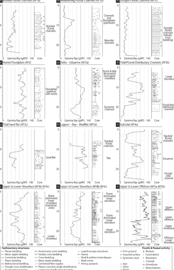
Based on the compilation and synthesis of internal studies (Eschard et al., 1999), and published papers on the Saharan Platform (Beuf et al., 1971; Eschard et al., 2005, 2010; Hen-niche, 2002) and on the Ahnet and Mouydir basins (Biju-Duval et al., 1968; Wendt et al., 2006), eleven main facies associations (AF1 to AF5) and four depositional environ-ments are proposed for the Devonian succession (Table 1). They are associated with their gamma-ray responses (Figs. 8 and 9). They are organized into two continental fluvial (AF1 to AF2), four transitional coastal plain (AF3a to AF3d), three shoreface (AF4a to AF4c), and two offshore (AF5a to AF5b) sedimentary environments.
5.1.1 Continental fluvial environments
This depositional environment features the AF1 (fluvial) and the AF2 (flood plain) facies association (Table 1). Facies association AF1 is mainly characterized by a thinning-up sequence with a basal erosional surface and trough cross-bedded intraformational conglomerates with mud clast lag deposits, quartz pebbles, and imbricated grains (Table 1). It passes into medium to coarse trough cross-bedded sand-stones, planar cross-bedded siltsand-stones, and laminated shales. These deposits are associated with rare bioturbation (except at the surface of the sets), ironstones, phosphorites, corroded quartz grains, and phosphatized pebbles. Laterally, facies as-sociation AF2 is characterized by horizontally laminated and very poorly sorted silt to argillaceous fine sandstones. They contain frequent root traces, plant debris, well-developed paleosols, bioturbation, nodules, and ferruginous horizons. Current ripples and climbing ripples are associated in pro-grading thin sandy layers.
In AF1, the basal erosional reworking and high energy pro-cesses are characteristic of channel-filling of fluvial systems (Allen, 1983; Owen, 1995). Eschard et al. (1999) identify three fluvial systems (see A, B, and C in Fig. 9) in the Tassili-N-Ajjers outcrops: braided dominant (AF1a), meandering
dominant (AF1b), and straight dominant (AF1c). They dif-ferentiate them by their different sinuosity, direction of ac-cretion (lateral or frontal), the presence of mud drapes, bio-turbation, and giant epsilon cross-bedding. Gamma-ray sig-natures of these facies associations (A, B, and C in Fig. 9) are cylindrical with an average value of 20 gAPI. The gamma-ray shapes are largely representative of fluvial environments (Rider, 1996; Serra and Serra, 2003; Wagoner et al., 1990). The bottom is sharp with high value peaks and the tops are frequently fining-up, which may be associated with high val-ues caused by argillaceous flood plain deposits and roots (Eschard et al., 1999). AF2 is interpreted as humid flood-plain deposits (Allen, 1983; Owen, 1995) with crevasse splays or preserved levees of fluvial channels (Eschard et al., 1999). Gamma-ray curves of AF2 (D, Fig. 9) show a rapid succession of low to very high peak values, ranging from 50 to 120 gAPI. AF1 and AF2 are typical of the Pragian “Oued Samene” Formation (Wendt et al., 2006). In the Il-lizi Basin, these facies are mainly recorded in the Ajjers For-mation (dated Upper Cambrian? to Ordovician, see Fabre, 2005; Vecoli, 2000; Vecoli et al., 1995, 1999, 2008; Vecoli and Playford, 1997) and the Lochkovian to Pragian “Barre Moyenne” and “Barre Supérieure” formations (Beuf et al., 1971; Eschard et al., 2005).
5.1.2 Transitional coastal plain environments
This depositional environment comprises facies associations AF3a (delta/estuarine), AF3b (fluvial/tidal distributary chan-nels), AF3c (tidal sand flat), and AF3d (lagoon/mudflat) (Ta-ble 1). AF3a is mainly dominated by sigmoidal cross-bedded heterolithic rocks with mud drapes. It is also characterized by fine to coarse, poorly sorted sandstones and siltstones often structured by combined flow ripples, flaser bedding, wavy bedding, and some rare planar bedding. Mud clasts, root traces, desiccation cracks, water escape features, and shale pebbles are common. The presence of epsilon bedding is attested, which is formed by lateral accretion of a river point bar (Allen, 1983). The bed surface sets are intensively bioturbated (Skolithos and Planolites) indicating a shallow marine subtidal setting (Pemberton and Frey, 1982). Faunas such as brachiopods, trilobites, tentaculites, and graptolites are present. AF3b exhibits a fining-up sequence featured by a sharp erosional surface, trough cross-bedded, very coarse-grained, poorly sorted sandstone at the base and sigmoidal cross-bedding at the top (Figs. 8 and 9). AF3c is formed by fine-grained to very coarse-grained sigmoidal cross-bedded heterolithic sandstones with multidirectional tidal bundles. They are also structured by lenticular, flaser bedding and occasional current and oscillation ripples with mud cracks. They reveal intense bioturbation composed of Skolithos (Sk), Thalassinoides(Th), and Planolites (Pl) ichnofacies indicat-ing a shallow marine subtidal settindicat-ing (Frey et al., 1990; Pem-berton and Frey, 1982). AF4d is characterized by horizon-tally laminated mudstones associated with varicolored shales
and fine-grained sandstones. They exhibit mud cracks, oc-casional wave ripples, and rare multidirectional current rip-ples. These sedimentary structures are poorly preserved be-cause of intense bioturbation composed of Skolithos (Sk), Thalassinoides(Th), and Planolites (Pl). The fauna includes ammonoids (rare), goniatites, calymenids, pelecypod molds, and brachiopod coquinas.
In AF3a, both tidal and fluvial systems in the same facies association can be interpreted as an estuarine system (Dal-rymple et al., 1992; Dal(Dal-rymple and Choi, 2007). The gamma-ray signature is characterized by a convex bell shape with rapidly alternating low to mid values (30 to 60 gAPI) due to the mud draping of the sets (see E Fig. 9). These forms of gamma ray are typical of fluvial–tidal influenced environ-ments with upward-fining parasequences (Rider, 1996; Serra and Serra, 2003; Wagoner et al., 1990). AF3a is identified at the top of the Pragian “Oued Samene” Formation and in Famennian “Khenig” Formation (Wendt et al., 2006) in the Ahnet and Mouydir basins. In the Illizi Basin, AF3a is mostly recorded at the top Cambrian of the Ajjers Formation, in the Lochkovian “Barre Moyenne”, and at the top Pragian of the “Barre Supérieure” Formation (Beuf et al., 1971; Eschard et al., 2005). The AF3b association can be characterized by a mixed fluvial and tidal dynamic based on criteria such as ero-sional basal contacts, fining-upward trends, or heterolythic facies (Dalrymple et al., 1992; Dalrymple and Choi, 2007). They are associated with abundant mud clasts, mud drapes, and bioturbation indicating tidal influences (Dalrymple et al., 1992, 2012; Dalrymple and Choi, 2007). The major differ-ence with the estuarine facies association (AF3a) is the slight lateral extent of the channels which are only visible in out-crops (Eschard et al., 1999). The gamma-ray pattern is very similar to the estuarine electrofacies (see F Fig. 9). AF3c is interpreted as a tidal sand flat laterally present near a delta (Lessa and Masselink, 1995) and associated with an estuar-ine environment (Leuven et al., 2016). The gamma-ray sig-nature (see G Fig. 9) is distinguishable by its concave funnel shape with alternating low and mid peaks (25 to 60 gAPI) due to the heterogeneity of the deposits and rapid variations in the sand/shale ratio. These facies are observed in the “Talus à Tigillites” Formation of the Illizi Basin (Eschard et al., 2005). In AF4d, both ichnofacies and facies are indicative of tidal mudflat/lagoonal depositional environments (Dalrym-ple et al., 1992; Dalrym(Dalrym-ple and Choi, 2007; Frey et al., 1990). The gamma-ray signature has a distinctively high value (80 to 130 gAPI) and an erratic shape (see H Fig. 9). AF4d is ob-served in the “Atafaitafa” Formation and in the Emsian pro-grading shoreface sequence of the Illizi Basin (Eschard et al., 2005). It is also recorded in the Lochkovian “Oued Samene” Formation and the Famennian “Khenig” sandstones (Wendt et al., 2006).
Figure 9. The main depositional environments (a–l) and their associated electrofacies (i.e., gamma-ray patterns) modified and compiled from Eschard et al. (1999).
5.1.3 Shoreface environments
This depositional environment is composed of AF4a (sub-tidal), AF4b (upper shoreface), and AF4c (lower shoreface) facies associations (Table 1). AF4a is characterized by the presence of brachiopods, crinoids, and diversified bioturba-tions, by the absence of emersion, and by the greater ampli-tude of the sets in a dominant mud lithology (Eschard et al., 1999). AF4b is heterolithic and composed of fine to medium-grained sandstones (brownish) interbedded with argillaceous siltstones and bioclastic carbonated sandstones. Sedimentary structures include oscillation ripples, swaley cross-bedding, flaser bedding, cross-bedding, convolute bedding, wavy bed-ding, and low-angle planar cross-stratification. Sediments were affected by moderate to highly diversified bioturba-tion by Skolithos (Sk), Cruziana, Planolites, (Pl) Chon-drites(Ch), Teichichnus (Te), Spirophytons (Sp) and are com-posed of ooids, crinoids, bryozoans, stromatoporoids, tabu-late and rugose corals, pelagic styliolinids, neritic tentaculi-tids, and brachiopods. AF4c can be distinguished by a low sand/shale ratio, thick interbeds, abundant hummocky cross-stratification (HCS), deep groove marks, slumping, and in-tense bioturbation (Table 1).
AF4a is interpreted as a lagoonal shoreface. The gamma-ray pattern (see I Fig. 9) is characterized by a concave bell shape influenced by a low sand/shale ratio with values fluc-tuating between 100 and 200 gAPI. AF4a is identified in the “Talus à Tigillites” Formation and the Emsian sequence of the Illizi Basin (Eschard et al., 2005) and in the Lochkovian “Oued Samene” Formation (Wendt et al., 2006). AF4b is in-terpreted as a shoreface environment. The presence of swaley cross-bedding produced by the amalgamation of storm beds (Dumas and Arnott, 2006) and other cross-stratified beds is indicative of upper shoreface environments (Loi et al., 2010). The gamma-ray pattern (see J and K Fig. 9) displays concave erratic egg shapes with a very regularly decreasing-upward trend and ranging from offshore shale with mid values (80 to 60 gAPI) to clean sandstone with lower values at the top (40 to 60 gAPI). AF4b is observed in the “Atafaitafa” For-mation corresponding to the “Zone de passage” ForFor-mation of the Illizi Basin (Eschard et al., 2005). AF4c is interpreted as a lower shoreface environment (Dumas and Arnott, 2006; Suter, 2006). The gamma-ray pattern displays the same fea-tures as the upper shoreface deposits with higher values (i.e., muddier facies) ranging from 100 to 80 gAPI (see J and K Fig. 9).
5.1.4 Offshore marine environments
This depositional environment is composed of AF5a and AF5b facies associations (Table 1). AF5a is mainly de-fined by wavy to planar-bedded heterolithic silty-shales in-terlayered with fine-grained sandstones. It also contains bun-dles of skeletal wackestones and calcareous mudstones. The main sedimentary structures are lenticular sandstones, HCS ,
mud mounds, low-angle cross-bedding, tempestite bedding, slumping, and deep groove marks. Sediments can present rare horizontal bioturbation such as Zoophycos (Z), Teichich-nus(Te), and Planolites (Pl). AF5b is characterized by an association of black silty shales with occasional bituminous wackestones and packstones. It is composed of graptolites, gonitaties, orthoconic nautiloids, pelagic pelecypods, lime-stone nodules, tentaculitids, ostracods, and rare fish remains. Rare bioturbation such as Zoophycos (Z) is visible.
In AF5a, the occurrence of HCS, the decrease in sand thickness and grain size, and the bioturbation and the floro– faunal associations indicate a deeper marine environment un-der the influence of storms (Aigner, 1985; Dott and Bour-geois, 1982; Reading and Collinson, 2009). AF5a is inter-preted as upper offshore deposits (i.e., offshore transitional). The gamma-ray pattern is serrated and erratic with values well grouped around high values from 120 to 140 gAPI (see L Fig. 9). Positive peaks may indicate siltstone to sandstone ripple beds. AF5b is interpreted as lower offshore deposits (Aigner, 1985; Stow et al., 2001; Stow and Piper, 1984). Here again the gamma-ray signature is serrated and erratic with values well grouped around 140 gAPI (see L Fig. 9). Hot shales with anoxic conditions are characterized by gamma-ray peaks (> 140 gAPI). These gamma-gamma-ray patterns are typ-ical of offshore environments dominated by shales (Rider, 1996; Serra and Serra, 2003; Wagoner et al., 1990). AF5a and AF5b are observed in the Silurian “Argiles à Grapto-lites” Formation and the Emsian “Orsine” Formation of the Illizi Basin (Beuf et al., 1971; Eschard et al., 2005; Legrand, 1986, 2003b). The “Argiles de Mehden Yahia” and “Argiles de Temertasset“ shales have the same facies (Wendt et al., 2006).
5.2 Sequential framework and unconformities
The high-resolution facies analysis, depositional environ-ments, stacking patterns, and surface geometries observed in the Devonian succession reveal at least two different orders of depositional sequences (large and medium scale, Fig. 8) considered as transgressive/regressive (T/R) (Catuneanu et al., 2009). The sequential framework proposed in Fig. 8b results from the integration of the vertical evolution of the main surfaces (Fig. 8a) and the gamma-ray pattern (Fig. 9). The Devonian series under focus exhibits 9 medium-scale se-quences (D1 to D9, Fig. 8; Figs. 10, 11, 12, and 13) bounded by 10 major sequence boundaries (HD0 to HD9), and 9 ma-jor flooding surfaces (MFS1 to MFS9). The correlation of the different sequences at the scale of the different basins and arches is used to build three cross sections – two E–W (Figs. 10, 11 and 12) and one N–S (Fig. 13).
The result of the analysis of the general pattern dis-played by the successive sequences reveal two major pat-terns (Figs. 10, 12 and 13) limited by a major flooding sur-face MFS5. The first pattern extends from the Oued Samene to Adrar Morrat formations and is dated from the
Lochko-Figure 10. SE–W cross-section between the Reggane Basin, the Azzel Matti Arch, the Ahnet Basin, the Arak-Foum Belrem Arch, the Mouy-dir Basin, and the Amguid El Biod Arch (well locations in Fig. 3). The well W1 biozone calibration is from Hassan (1984) and the internal report is based on the Magloire (1967) classification: biozone G3-H (Wenlock–Ludlow, Upper Silurian), biozone I-K (Lochkovian–Emsian, Lower Devonian), biozone L1-3 (Eifelian–Givetian, Middle Devonian), biozone L4 (Frasnian, Upper Devonian), biozone L5-7 (Famennian, Upper Devonian), and biozone M2 (Tournaisian–Lower Carboniferous). The well W7 biozone calibration is from Azzoune (1999) and the internal report is based on the Boumendjel (1987) classification: biozone 7–12 (Lochkovian, Lower Devonian) and biozone 15 (Emsian, Lower Devonian). Interpretation of the basement is based on Figs. 1, 2, and 15. Well location is in Fig. 2.
vian to Givetian. D1 to D5 medium-scale sequences indicate a general proximal clastic depositional environment (dom-inated by fluvial to transitional and shoreface facies) with intensive lateral facies evolution. This first pattern is thin (from 500 m in the basin depocenter to 200 m around the basin rim) and with successive amalgamated surfaces on the edge of the arches between the “Zone de passage” and “Oued Samene” formations (e.g., Figs. 10 and 13). It is de-limited at the bottom by the HD0 surface corresponding to the Silurian–Devonian boundary. D1 to D3 are composed of T/R sequences with a first deepening transgressive trend in-dicative of a transition from continental to marine deposits bounded by a major MFS and evolving into a second shal-lowing trend from deep marine to shallow marine deposi-tional environments. D1 to D3 thin progressively toward the edge and the continental deposits, in the central part of the basin, pass laterally into a major unconformity. The amalga-mation of the surfaces and lateral variations of facies between the Ahnet Basin and Azzel Matti and Arak-Foum Belrem arches demonstrate a tectonic control related to the presence of subsiding basins and paleo-highs (i.e., arches).
D4 and D5 display the same T/R pattern with a reduced continental influence and upward decrease in lateral facies variations and thicknesses where the MFS4 marks the be-ginning of a marine-dominated regime in the entire area. It is identified as the Early Eifelian transgression defined by Wendt et al. (2006). The D5 sequence is mainly composed of shoreface carbonates. Evidence of mud mounds preferen-tially located along faults are well-documented in the area for that time (Wendt et al., 1993, 1997, 2006; Wendt and Kauf-mann, 1998). This change in the general pattern indicates re-duced tectonic influence.
MFS5, at the transition between the two main patterns, represents a major flooding surface on the platform and is featured worldwide by deposition of “hot shales” during the early Frasnian (Lüning et al., 2003, 2004; Wendt et al., 2006). The second pattern extends from the “Mehden Yahia”, “Temertasset” to the “Khenig” formations dated Frasnian to Lower Tournaisian. This pattern is composed of part of D5–D9 medium-scale sequences. It corresponds to homoge-nous offshore depositional environments with no lateral fa-cies variations. However, local deltaic (fluvio–marine) con-ditions are observed during the Frasnian at the Arak Foum Belrem Arch (“Grès de Mehden Yahia” in Fig. 12). A suc-cessive alternation of shoreface and offshore deposits is or-ganized into five medium-scale sequences (part of D5, and D6 to D9; Figs. 10, 11 and 12). They, in particular, show some regressive phases with the deposition of both “Grès de Mehden Yahia” and “Grès du Khnig” sandstones (bounded by HD6 and HD9). This pattern (i.e., part of D5 to D9) cor-responds to the general maximum flooding (Lüning et al., 2003, 2004; Wendt et al., 2006) under eustatic control with no tectonic influences.
6 Subsidence and tectonic history: an association of low rate extensional subsidence and positive inversion pulses
The backstripping approach (Fig. 14) was applied to five wells (W1, W5, W7, W17, and W21). The morphology of the backstripped curve and subsidence rates can provide clues as to the nature of the sedimentary basin (Xie and Heller, 2009). In intracratonic basins, reconstructed tectonic subsi-dence curves are almost linear to gently exponential in shape, similar to those of passive margins and rifts (Xie and Heller, 2009). The compilation of tectonic backstripped curves from several wells in peri-Hoggar basins (Fig. 14a, see Fig. 1 for location) and from wells in the study area (Fig. 14b) display low rates of subsidence (from 5 to 50 m Myr−1) organized in subsidence patterns of: inversion of the low rate subsidence (ILRS type c, red line, Fig. 14c), deceleration of the low rate subsidence (DLRS type b, black line), and acceleration of the low rate subsidence (ALRS type a, blue line).
Each period of ILRS, DLRS, and ALRS may be syn-chronous among the different wells studied (see B1 to J, Fig. 14b) and some wells from published data (see D to J Fig. 14a).
The Saharan Platform is marked by a rejuvenation of base-ment structures, around arches (Figs. 1, 2, and 3), linked to regional geodynamic pulses during Neoproterozoic to Pale-ozoic times (Fig. 14). A compilation of the literature shows that the main geodynamic events are associated with discrim-inant association of subsidence patterns:
a. Late Pan-African compression and collapse (patterns a, b, and c, A Fig. 14a). The infra-Cambrian (i.e., top Neo-proterozoic) is characterized by horst and graben ar-chitecture associated with wedge-shaped unit DO0 in the basement (Fig. 7). This structuring, probably re-lated to Pan-African post-orogenic collapse, is illus-trated by intracratonic basins infilled with volcano-sedimentary molasses series (Ahmed and Moussine-Pouchkine, 1987; Coward and Ries, 2003; Fabre et al., 1988; Oudra et al., 2005).
b. Cambrian–Ordovician geodynamic pulse (Fig. 14). Highlighted by the wedge-shaped units DO1 (Figs. 6a and 7), the horst and graben system is correlated with deceleration (DLRS pattern a, B1) and with local ac-celeration of the subsidence (ALRS pattern b, B2). The Cambrian–Ordovician extension is documented on arches (Arak-Foum Belrem, Azzel Matti, Amguid El Biod, Tihemboka, Gargaf, Murizidié, Dor El Gussa, etc.) of the Saharan Platform by synsedimentary nor-mal faults, reduced sedimentary successions (Bennacef et al., 1971; Beuf et al., 1968a, b, 1971; Beuf and Mon-tadert, 1962; Borocco and Nyssen, 1959; Claracq et al., 1958; Echikh, 1998; Eschard et al., 2010; Fabre, 1988; Ghienne et al., 2003, 2013; Zazoun and Mahd-joub, 2011), and by stratigraphic hiatuses (Mélou et al.,
Figure 11. SE–W cross section between the Arak-Foum Belrem Arch, the Mouydir Basin, and the Amguid El Biod Arch. Outcrop cross-section correlations and biostratigraphic calibrations are based on the compilation of published papers (Wendt et al., 2006, 2009b). Interpre-tation of the basement is based on Figs. 1, 2, and 15. Outcrop location is in Fig. 2.
1999; Oulebsir and Paris, 1995; Paris et al., 2000; Vecoli et al., 1995, 1999).
c. Late Ordovician geodynamic pulse (i.e., Hirnantian glacial and isostatic rebound; Fig. 14). Late Ordovi-cian incisions mainly situated at the hanging walls of normal faults (Fig. 7c and d) are interpreted as Hirnan-tian glacial-paleovalleys (Le Heron, 2010; Smart, 2000) and followed by local inversion of low rate subsidence (ILRS of type c, C in Fig. 14).
d. Silurian extensional geodynamic pulse (D, Fig. 14). The Silurian post-glaciation period is featured by the reac-tivation and sealing of the inherited horst and graben fault system (i.e., wedge-shaped unit DO2; Figs. 6b, c, 7a and b). It is linked to an acceleration of the subsi-dence (ALRS of pattern b in Fig. 14). This tectonic ex-tension is documented in seismic records (Najem et al., 2015) and is associated with the Silurian major trans-gression on the Saharan Platform (e.g., Eschard et al., 2005; Lüning et al., 2000).
e. Late Silurian to Early Devonian geodynamic pulse (Caledonian compression; E Fig. 14). Late Silurian times are marked by reactivation and local positive inversion of the former structures (Figs. 6c and 7b);
this occurs due to truncations located at fold hinges (Figs. 6c and 7) and due to a major shift from marine to fluvial/transitional environments (e.g., Fig. 10). Back-stripped curves register an inversion of the subsidence (ILRS of pattern c, in Fig. 14). The Caledonian event is mentioned as related to large-scale folding or uplifted arches (e.g., the Gargaff, Tihemboka, Ahara, Murizidé-Dor el Gussa and Amguid El Biod arches) and it is as-sociated with breaks in the series and with angular un-conformities (Beuf et al., 1971; Biju-Duval et al., 1968; Boote et al., 1998; Boudjema, 1987; Boumendjel et al., 1988; Carruba et al., 2014; Chavand and Claracq, 1960; Coward and Ries, 2003; Dubois and Mazelet, 1964; Echikh, 1998; Eschard et al., 2010; Fekirine and Ab-dallah, 1998; Follot, 1950; Frizon de Lamotte et al., 2013; Ghienne et al., 2013; Gindre et al., 2012; Legrand, 1967a, b; Magloire, 1967).
f. Early Devonian tectonic quiescence (F Fig. 14). This is characterized by a deceleration of the low rate sub-sidence (DLRS of pattern a, F in Fig. 14). During this period, we have detected Emsian truncation from satel-lite images (Fig. 6d and e) and erosion and pinch out of Upper Emsian to Eifelian series from well cross sec-tions (Figs. 10, 12 and 13). In previous works, these hiatuses/gaps (i.e., Upper Lochkovian, Lower Pragian,
Figure 12. NE–W cross section between the Reggane Basin, the Azzel Matti Arch, the Ahnet Basin, the Arak-Foum Belrem Arch, the Mouydir Basin, and the Amguid El Biod Arch. The well W18 biozone calibration is based on Kermandji et al. (2009): biozone (Tm) tidikeltense microbaculatus(Lochkovian, Lower Devonian), biozone (Es) emsiensis spinaeformis (Lochkovian–Pragian, Lower Devonian), biozone (Ac) arenorugosa caperatus (Pragian, Lower Devonian), biozone (Ps) poligonalis subgranifer (Pragian–Emsian, Lower Devonian), biozone (As) annulatus svalbardiae (Emsian, Lower Devonian), biozone (Mp) microancyreus protea (Emsian–Eifelian, Lower to Middle Devonian), and biozone (Vl) velatus langii (Eifelian, Middle Devonian). The well W19 and W20 biozones calibration from internal reports (Abdesselam-Rouighi, 1991; Khiar, 1974) is based on the Magloire (1967) classification: biozone H (Pridoli, Upper Silurian), biozone I (Lochkovian, Lower Devonian), biozone J (Pragian, Lower Devonian), biozone K (Emsian, Lower Devonian), and biozone L1-5 (Middle Devonian to Upper Devonian). Interpretation of the basement is based on Figs. 1, 2, and 15. Outcrop and well location is in Fig. 2.
Figure 13. N–S cross section in the Ahnet Basin between Azzel Matti Arch and Arak-Foum Belrem Arch; well W7 biozone calibration from Azzoune, (1999) internal report based on the Boumendjel (1987) classification: biozones 7–12 (Lochkovian, Lower Devonian), biozone 15 (Emsian, Lower Devonian). Well W18 biozone calibration is based on Kermandji et al. (2009): biozone (Tm) tidikeltense microbaculatus (Lochkovian, Lower Devonian), biozone (Es) emsiensis spinaeformis (Lochkovian–Pragian, Lower Devonian), biozone (Ac) arenorugosa caperatus(Pragian, Lower Devonian), biozone (Ps) poligonalis subgranifer (Pragian–Emsian, Lower Devonian), biozone (As) annulatus svalbardiae(Emsian, Lower Devonian), biozone (Mp) microancyreus protea (Emsian–Eifelian, Lower to Middle Devonian), and biozone (Vl) velatus langii (Eifelian, Middle Devonian). The well W12 biozone calibration from Abdesselam-Rouighi (1977) internal report is based on the Boumendjel (1987) classification: biozone J (Pragian, Lower Devonian), biozone K (Emsian, Lower Devonian), biozone L1 (Eifelian, Middle Devonian), and biozone L7-3, L7-9 (Frasnian–Famennian, Upper Devonian). Interpretation of the basement is based on Figs. 1, 2, and 15. Outcrop and well location is in Fig. 2.
Figure 14. (a) Tectonic backstripped curves of the Paleozoic North Saharan Platform (peri-Hoggar basins) compiled from literature. 1: HAD-1 well in Ghadamès Basin (Makhous and Galushkin, 2003b); 2: well RPL-HAD-10HAD-1 in Reggane Basin (Makhous and Galushkin, 2003b); 3: LHAD-1- L1-1 well in Murzuq Basin (Galushkin and Eloghbi, 20L1-14); 4: TGE-L1-1 in Illizi Basin (Makhous and Galushkin, 2003a); 5: REG-L1-1 in Timi-moun Basin (Makhous and Galushkin, 2003b); 6: Ghadamès-Berkine Basin (Allen and Armitage, 2011; Yahi, 1999); 7: well in Sbâa Basin (Tournier, 2010); and 8: well B1NC43 in Al Kufrah Basin (Holt et al., 2010). (b) Tectonic backstripped curves of wells in the study area 1: well W17 in Ahnet Basin; 2: well W5 in Ahnet Basin; 3: well W7 in Ahnet Basin; 4: well W21 in Mouydir Basin; and 5: well W1 in Reg-gane Basin. (c) Typologies of subsidence curves morphologies. A: Late Pan-African compression and collapse (type a, b, and c subsidence), B: undifferentiated Cambrian–Ordovician (type a, b, and c subsidence), B1: Cambrian–Ordovician tectonic quiescence (type a subsidence), B2: Cambrian–Ordovician extension (type b subsidence), C: Late Ordovician glacial and isostatic rebound (type c subsidence), D: Silurian extension (type b subsidence), E: Late Silurian Caledonian compression (type c subsidence), F: Early Devonian tectonic quiescence (type a subsidence), G–H: Middle to late Devonian extension with local compression (i.e., inversion structures, type b and c subsidence), I: Early Carboniferous extension with local tectonic pre-Hercynian compression (type c and b subsidence), and J: Middle Carboniferous tectonic extension (type b subsidence).