HAL Id: insu-01887051
https://hal-insu.archives-ouvertes.fr/insu-01887051
Submitted on 3 Oct 2018
HAL is a multi-disciplinary open access
archive for the deposit and dissemination of
sci-entific research documents, whether they are
pub-lished or not. The documents may come from
teaching and research institutions in France or
abroad, or from public or private research centers.
L’archive ouverte pluridisciplinaire HAL, est
destinée au dépôt et à la diffusion de documents
scientifiques de niveau recherche, publiés ou non,
émanant des établissements d’enseignement et de
recherche français ou étrangers, des laboratoires
publics ou privés.
Tertiary deformation and metamorphism SE of Tibet:
The folded Tiger-leap d6collement of NW Yunnan,
China
Robin Lacassin, Urs Schärer, P Leloup, Nicolas Arnaud, Paul Tapponnier,
Xiaohan Liu, Liansheng Zhang
To cite this version:
Robin Lacassin, Urs Schärer, P Leloup, Nicolas Arnaud, Paul Tapponnier, et al.. Tertiary deformation
and metamorphism SE of Tibet: The folded Tiger-leap d6collement of NW Yunnan, China. Tectonics,
American Geophysical Union (AGU), 1995, 15 (3), pp.605-622. �10.1029/95TC03749�. �insu-01887051�
TECTONICS, VOL. 15, NO. 2, PAGES, 605-622, JUNE 1996
Tertiary deformation and metamorphism SE of Tibet: The
folded Tiger-leap d6collement of NW Yunnan, China
Robin Lacassin,
• Urs Sch•irer,
2 P. Herv6 Leloup, • Nicolas Arnaud,
3
Paul Tapponnier,
• Xiaohan Liu, 4 and Liansheng Zhang
•
Abstract. The Yulong-Haba Xue Shan range, in the north- western part of Yunnan (China), is a large N-S antiform that folds the Paleozoic series of the Yangzi platform. The upper Yangzi River (Jinsha Jiang) has cut a 3500 m-deep valley (Hu Tiao gorge) across this antiform, thus exposing folded, bedding-parallel, ductile shear zones (d6collements), with transport toward the SSW (in the present geographical coordi- nates). The large finite shear strain implies tens of kilometers of transport, pointing to the regional significance of these d6collements. R b/Sr radiometric dating of phlogopites that crystallized in marbles within the foliation planes yields the age of the metamorphic and deformation event (35.9 + 0.3 (2{5) Ma). The age derives from an internal Rb-Sr isochron, made on different size fractions of the same mineral, which provides a novel demonstration of the feasibility of such plots. Transport on the d6collement and related shortening occurred prior to, or at the onset of, extrusion of Indochina along the Ailao Shan-Red River shear zone, --80 km west of the Yulong
Shan. The 3OAr / 4øAr age spectra of K-feldspar from the core of
the Yulong Shan suggest uplift by antiformal folding around 17 Ma, as Indochina's extrusion came to an end. We infer that other large-scale Cenozoic d6collements such as that ex- humed in the Yulong Shan underlie some of the vast, folded areas that surround the eastern Himalayan syntaxis. Transport on such d6collements, first toward the south and then toward the east, and folding above them, might have occurred during two principal shortening phases, whose ages bracket Indochina's escape toward the SE.
1. Introduction
During the =50-Myr time span of India's collision with Asia, the convergence between the two continents has been absorbed both by crustal thickening on large-scale thrusts and by the lateral extrusion of continent-size blocks along great
strike-slip faults [Tapponnier et o2, 1986; Peltzer and
• Laboratoire de Tectonique, M6canique de la Lithosphere, URA
1093 CNRS, Institut de Physique du Globe de Paris, Paris, France.
2 Laboratoire de G6ochronologie, URA 1093 CNRS, Universit6
Paris 7 and Institut de Physique du Globe de Pads, Paris, France.
3 URA l0 CNRS, Magmas et Volcans, Universit6 de Clermont-
Ferrand, Clermont-Ferrand, France.
4 Academia Sinica, Beijing, China.
Copyright 1996 by the American Geophysical Union.
Paper number 95TC03749.
0278-7407/96/95TC-03749512.00
Tapponnier, 1988; Armijo et al., 1989]. While the proportions of shortening absorbed by either mechanism are still debated [e.g., Englandand Houseman, 1986; Tapponnier et al., 1986; England and Molnar, 1990; Le Pichon et al., 1992; Avouac and Tapponnier, 1993; Leloup et o2, 1995], the idea that India's penetration into Asia induced extrusion of Indochina toward the SE [Tapponnier et al., 1986; Tapponnier et al., 1990a]. prior to that, which is presently underway, of Tibet and South China [Armijo et al., 1989; Avouac and Tapponnier, 1993], is now supported by abundant geological and geochronological evidence [Tapponnieret o2, 1990a; Leloup, 1991; Lacassin et a/., 1993; Yang Zhenyu and Besse, 1993; Leloup et al., 1995; Yang Zhenyu et al., 1995]. Such field evidence, which rests
firmly on accurate U/Pb and 39Ar/4øAr
radiometric
dating
[Schiirer et al., 1990; Harrison et al., 1992; Leloup et al., 1993; Schiirer et al., 1994], implies that a large amount of sinistral motion took place on the Ailao Shan-Red River shear zone, the main tectonic boundary between Indochina and South China, between the upper Eocene and the Miocene (35-17 Ma). Much less is known, however, about Tertiary defor- mation within regions north and south of that zone. How much shortening affected the crust of these regions, when, and how it was related to strike-slip motion remain to be assessed. As a step toward unraveling the kinematics, timing, and amount of Cenozoic shortening in the area surrounding the eastern Himalayan syntaxis, we present here the results of a structural study of polyphase shortening within the Yulong Shan range (northwestern Yunnan), combined with radiometric dating of greenschist metamorphism in the core of that range.2. Geology and Structure of the Yulong
Shan Antiform2.1. Brief Summary of the Geology of NW Yunnan
Yunnan province (China) is cut by the Ailao Shah-Red River shear zone, which extends --1000 km from eastern Tibet
to the South China Sea (Figure la). The narrow belt of high-
grade mylonitic gneisses exposed along that zone, in the
Xuelong Shah, Diancang Shah, Ailao Shah, and Day Nui Con
Voi, provides outstanding evidence for ductile sinistral shear, testifying to the southeastward extrusion of Indochina [Tapponnier et al., 1990a; Leloup, 1991; Lacassin et al., 1993;
Leloup et al., 1995]. The finite offset along the zone appears to be of the order of 700 + 200 km [Briais et al., 1993; Leloup et
O2, 1995]. U/Pb ages obtained on variably deformed anatectic
melts imply that sinistral shear under crustal melting condi-
tions took place from at least 35 to 22 Ma [Sch•irer et al.,
1990; Sch•irer
et al., 1994]. Modeling
of 39Ar/4øAr
outgassing
patterns of K-feldspar further implies that transtensive uplift
606 LACASSIN ET AL.: TERTIARY DEFORMATION SE OF TIBET
Strike-slip Fault
IjI
Tertiary1/$
Quat�
rnary�
Red bed/.
Shear senseTertiary suture
�
baSins .: Antiform aXIs
Figure 1a. Map of major Cenozoic structures around eastern Himalayan syntaxis. Abbreviations are K.F., Kunlun Fault; X.F., Xianshuihe Fault; KJ.F.Z., Karakorum-liali Fault zone; Y.Z., Yalong Zangbo; S.F., Sagaing Fault; A.S.R.R., Ailao Shan Red River shear zone; G.F.Z., Gaoligong Fault zone; W.C.F., Wang Chao Fault; T.P.F., Three Pagodas Fault; D.B.P., Dien Bien Phu Fault; c., Chuxiong basin; S., Simao basin. Curved arrows indicate clockwise sense of rotation of blocks between strike-slip faults, inferred from paleomagnetic studies (see discussion in text). Box shows area of Figure lb.
accompanied sinistral motion till about 17 Ma [Harrison et at. , 1992; Leloup et al., 1994; Harrison et at., 1995]. Evidence of motion along the fault zone between = 17 and 5 Ma is scarce and inconclusive. Around 5 Ma, however [Leloup et at., 1993], the sense of shear appears to have reversed to right lateral [Tapponnier and Molnar, 1977; Allen et at., 1984], a result of South China's extrusion by India's greater penetration into the interior of Asia [Tapponnier et al., 1986; Armijo et aJ., 1989]. Such motion is still underway, and much of Yunnan province is currently affected by ENE extension and NNW shortening,
as attested by widespread active strike-slip and normal faultng [Tapponnier and Molnar, 1977; Allen et at., 1984; Leloup, 1991; Leloup et at., 1995].
North and south of the Red River, the Chuxiong and Simao basins (Figure la) are filled by thick sequences (up to 6 km) of Upper Triassic to lower Tertiary red beds [Geological Bureau of Yunnan Province, 1979; Bureau of Geology and Mineral Resources of Yunnan, 1983]. The red beds are folded by NW to NNW trending anticlines, implying NE to ENE directed Tertiary shortening, compatible with left-lateral movement on t
h
e Ailao Shan-Red River zone [Tapponnier et aJ., 1990a; Leloup et at., 1995]. In the Chuxiong basin, the anticlines have generally steep axial planes, with similarly steep cleavage in their cores. In the southern part of this basin, near the Ailao Shan-Red River zone, this cleavage becomes stronger and, together with the fold axes, bends counter clockwise to parallel the foliation in the Ailao Shan mylonites, suggesting that folding and left-lateral shear were coeval, at least in part [ Tapponnier et at., 1990a; Leloup et at.,1995].
NW of the Chuxiong basin, both the average elevation and relief increase as one approaches Tibet and the eastern Himalayan syntaxis, located less than =500 km farther west (Figure l a). There, the NW trending Ailao Shan-Red River zone merges with long and narrow tectonic belts bounded by roughly N-S faults (Figure Ib). These belts, along which strike-slip motion probably took place in the Cenozoic, channel the Jinsha, Lancang, and Nu Jiang (Yangzi, Mekong, and Salween Rivers, respectively). East of them, between the Cheng Hai and J ianchuan faults (Figure 1 b), the Lijiang Mountains expose strongly folded, faulted, and uplifted Mid Paleozoic to Triassic rocks [Geological Bureau of Yunnan Province, 1979; Bureau of Geology and Mineral Resources of Yunnan, 1983; Wang and Chu, 1988]. These rocks, which belong to the cover of the Yangzi platform, comprise clastic deposits and shallow water carbonates with interbedded basalts. Most of the basalts are of mid-upper Permian age. The highest range of the area, NW of Lijiang, is the Yulong Shan, site of the present study (Figure Ib and 2).
2.2. Structure of the Yulong Shan Massif
The Yulong Shan ("Jade Dragon Mountain") is a =20-km wide, =50-km-long range with sharp N-S crests, marked l7y pinnacles culminating at 4500 to 5600 m. The surrounding country has an average elevation of =3000 m (Figures 3 and 4). The highest summits are the Yulong Xue Shan (5595 m) and the Haba Xue Shan (5396 m) south and north of the Jinsha Jiang, respectively (Figures 2, 3, and 4).
The Yulong Shan is bounded to the east by steeply dipping Quaternary faults that are clear on aerial photographs, on the topographic maps and digital elevation model (DEM), and in the field (Figures 3 and 4). Some of the historical and instru mental earthquakes recorded in the region [Gu Gongxu et at., 1989] may be related to slip on those faults. Between Lijiang and Daju, the faults appear to be mostly normal and strike roughly N-S (Figure 3). The main fault dips east and limits the steep, 1000- to 2000-m-high eastern flank of the range (Figure 4). About 15 km north of Lijiang, several east or west facing normal fault scarps cut the ancient moraines of glaciers flowing down from the Yulong Shan (letters a and b on Figure
LACASSIN ET AL.' TERTIARY DEFORMATION SE OF TIBET 607 ß o 28ø00 ' 9/28/1966 Yulon9 Shan ;:1:: 27020 '
t
99 øStrl•ka;i•lip_
• Tertiary
•lr/•
Quaternary
Normal Fault (active) o40' 100 ø•
...
Mylonites
(RRFZ):-•
...
Gneisses
(Ga,•ll?aønr•g
+[•"• Granites
:'
Anticlinal
ß axesoøOoø•
Quaternary
I::"::'] Mid-Tertiary
Molasse:...':• Mesozoic
red beds•
Paleozoic
Thrust
.:
O Fault
plane
solution
O Historical
earthquake
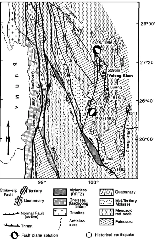
Figure lb. Simplified structural sketch map of northern Yunnan after Leloup et al. [1995], showing location
of Yulong Shan. Abbreviations are D.C.S., Dian Cang Shan; X.L.S., Xue Long Shan; R.R.F., Red River Fault zone. Dashed box refers to Figure 3.
3) and the fiat floor surface of the Lijiang basin (c on Figure
3). West of Daju, the Daju Fault limits the northeastern flank
of Haba Xue Shan and seems to continue SE of Daju (d on
Figure 3). This fault strikes N130øE, roughly parallel to the right-lateral Zhongdian and Xiaohou strike-slip faults (Figure lb). The village of Daju is located on top of thick (> 200 m)
flat Quaternary terraces that fill a small intermontane basin
(Figures 4, 5, and 6a). We infer this accumulation of clastic sediments on the hanging wall of the Daju fault to result from normal downthrow on that fault. The Jinsha River, which flows here at =1580 m above sea level (asl), has incised the ter-
races by about 150 m. Upstream, on the footwall of the Daju Fault, much thinner terraces rest unconformably on the steeply
608 LACASSIN ET AL.: TERTIARY DEFORMATION SE OF TIBET Triassic (T) •
•
Permian
(P2)basalts
'"/':':'
'"'• L.
Permian
(P
1
)
•
Carboniferous
(C)
! . ßNormal
(active)fault
Low-angle thrust(decollement)
Steeply
dipping
thrust
Figure 2. Simplified geological sketch map of Yulong Shan, modified after 1'500,000 geologic map of Yunnan [ Geological Bureau of Yunnan Province, 1979].
range, about 50 m above the Daju terrace surface (Figures 6a and 6b).
On most extant maps [Geological Bureau of Yunnan Province, 1979; Bureau of Geology and Mineral Resources of Yunnan, 1983] the Yulong Shan corresponds to a broad N-S antiform exposing the Paleozoic series of the Yangzi platform (Figure 2). The main topographic crest of the range outlines the top of this antiform (Figures 3 and 4). On the 1:106
geological map of Yunnan [Bureau of Geology and Mineral
Resources of Yunnan, 1983], the Yulong Shan is mapped as a
simple west facing anticline folding Lower Devonian to Permian beds, while its structure appears more complex on the 1:500 000 geological map [Geological Bureau of Yunnan Province, 1979] (Figure 2). In and along the western flank of the antiform the latter map shows steep, apparently reverse,
N-S faults (Figure 2) cutting a shallowerS dipping fault in the
core of the antiform. In part, the latter fault roughly follows the boundary between lower (D1) and middle (D2) Devonian, suggesting that it might be a d{Scollement or detachment refolded by the antiform (Figure 2). Between Lunan and Daju
Figure 3. Map of structural data obtained in Yulong Shan massif. Circled letters a to d refer to sites cited in text. View points for photographs of Figures 6a and 6b are also located on map. Circled letters U and D point to upstream and downstream parts of Hu Tiao gorge and correspond to diagrams of Figures 10a and 10b, respectively. Cross section A-B corresponds to synthetic section of Figure 5. Fault plane solutions (lower hemisphere) and open circles correspond to epicenters of instrumental and major historical earth- quakes, respectively. Topography is from 1:100,000 Chinese topographic maps (contour spacing is 200 m).
LACASSIN ET AL.: TERTIARY DEFORMATION SE OF TIBET 609 27o20'N 27ø20'N 27ø10'N 27o10'N
Marble
beds
Greenschists
Grey
calcshists
Fault
Active
normal
fault
•
lacier
RoadView point
for Fig,6a
and 6b
Site
described
in text
(•(•) Upstream
and downstreampart of the gorge
• ooo I 10km /1, / lOOOl Figure 3.
/
/ /, //,/•,o
LIJIANG 27o00'N610 LACASSIN ET AL.: TERTIARY DEFORMATION SE OF TIBET ..".'.• •-• • :, ,, ,•:• • ..: , = •- ... , ::• • " Fault ....
- .•:•?.•:%
...
,, , .
....
:..;--:•.:•-:
,,.,,.•,...¾•,•.•:.
... : ,; •v•
'•.
_•:?•.
' ':/?--•:•.,••.,•..
'
...
Marble
•?,.•'
... ,
.;•?'?•.
?•;
Layer •.?
•,•..•.[isure 4. Digital elevation model (DEM) of Yu]on• Shah (•ridded topography extracted from ]']00,000 topographic maps). (a) Shaded vertical view with illumination from NW. Main crests of Yulon• and Haba ranges outline shape of antiform (Ei•ures 3 and 5). Quaternary normal faults bound steep eastern flanks of these ranges (Figure 3). (b) Structural sketch showin• contours of one marble layer, stron• horizons above, and normal faults at base of eastern flank. (c) Three dimensional •iew of DEM taken from the south and
illuminated from NW.
(Figure 3), the Jinsha Jiang has cut across the antiform a --3500-m-deep "cluse" (specific term for a river incised wind gap transverse to an anticline), possibly one of the greatest in the world, forming the famous "Tiger-leap" gorge (Hutiao
Xia), (Figures 4, 6a and 6b). This narrow gorge provides a
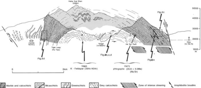
spectacular, fairly complete, section of the Yulong antiform, accessible along a foot path on the left bank of the Jinsha River (Figures 3 and 5).
2.3. Hutiao Gorge Section
2.3.1. Overall structure of the Hutiao gorge section. Entering the gorge from the NE, one first encounters the steep
Daju Fault zone, marked by brecciated marbles and slices of
red sandstones (possibly of upper Triassic or Jurassic age). SW of this fault, greenschists (with quartz, white micas, chlorite, biotite, actinolite, epidote), which we infer to corre- spond to metamorphosed Permian basalts, lie conformably on top of thick, 30ø-50øE dipping marbles (upper Devonian to
Permian ?) (Figures 3 and 5). Particularly strongly deformed light grey marbles and calcschists, containing horizons of greenish to light brown schists and boudins of amphibolites or basalts, form spectacular slabs at the entrance of the gorge (Figures 6a and 6b). The marbles grade downward into black schists and slates with more marbles and dolomitic horizons with some amphibolite boudins (Figure 6c), in turn overlying less deformed white yellow marbles bearing white and pink micas (muscovite, phlogopite). -
A series of black and grey schists and micaschists with quartzite and greywacke layers, in which cross bedding is locally preserved (normal polarity), crops out in the deepest part (core) of the antiform (Figures 3 and 5). Such schists probably derive from finely laminated sandstones and volcani- clastic rocks (lower Devonian?). The micaschists bear biotite (often forming elongated centimetric spots on the foliation planes), muscovite, chlorite, and ribbons of small (<100 gm), nearly isotropic grains of quartz, K feldspar, and plagioclase. In some samples, chlorite and muscovite underline a crenu-
LACASSIN ET AL.: TERTIARY DEFORMATION SE OF TIBET 61 l wsw ENE ig r Lap (Hu Tiao) o 5km I • I Fig.6c 4000 • '.•-:..:
i
7
J Fig•a YN85 YN75Feldspar (39Ar/40Ar) phlogopite (35.9 +_ 0.3Ma)
(Rb/Sr)
"•"
'""
•'•AA••
Marble
and
caicschists
'"w'•--•
Micaschist
s I •:d•
Gree.schs,s
'•• Grey
calcschists
•
Zone
of
intense
shearing
•k.
Amphibolite
boudins
Figure 5. Synthetic section of Yulong Shan massif through Hu Tiao gorge (section trace located on Figure3). Structural observations along Hu Tiao gorge are projected parallel to antiform axis.
lation cleavage parallel to axial planes of minor decimetric folds affecting the foliation planes (Figure 5). The micaschists also contain porphyroclasts (• 500 gm) of carbonate minerals,
which we infer to be siderite (CO3Fe) from their high refrin-
gence. Association of biotite, chlorite and muscovite indicates
greenschist metamorphic grade. In spite of the availability of
Ca, A1, and Fe, no grossular or andradite garnets formed in the micaschists, suggesting that temperature never exceeded 450øC in the deepest part of the Yulong Shan antiform.
Toward the west, in the western limb of the antiform, the
marbles are found again, with almost the same lithological
units as in the eastern limb (Figures 3 and 5), but with less
intense deformation. At the famous Tiger-leap locality (rapids
in the narrowest part of the gorge), vertical to overturned
marble beds (Figures 5 and 6d) form a sharp N-S crest
(Figures 3, 4, 5, and 6d). West of these marbles, vertical to
overturned greenschists (metabasalts ?) overlie east dipping
grey calcschists of probable Triassic age (Figure 5).
Overall, along the Tiger-leap gorge section, the Yulong Shah antiform is thus best interpreted as a simple west verging anticline as suggested by inspection of the geological maps.
Minor complications, in the form of smaller-scale folds, are
mostly found near the hinge of the anticline (Figure 5). Along
section, however, we found inconclusive evidence for the
reverse faults cutting the western flank of the antiform (Figure
2). Such faults, if they exist, must be steep and almost parallel to the nearly vertical bedding.
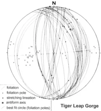
2.3.2 Microstructures: Characters of ductile strain. A well-developed, bedding-parallel foliation affects most of the marbles and schists along section (Figure 7). Together with
the stretching lineation, which is very spectacular at places
(Figure 8a), the foliation is thus folded by the antiform.
Ductile deformation has been particularly strong in the mar- bles of the eastern flank and in the micaschists that underly the marbles (Figures 5 and 9). There, bedding-parallel shear has produced intense compositional banding of the rocks with pervasive boudinage of stiffer layers (amphibolites, quartz veins) and, locally, sheath folds (Figure 8b).
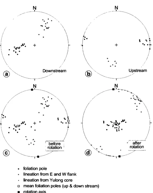
Bedding and foliation planes strike N-S +30 ø. A great circle best fitting the distribution of bedding-foliation poles defines an antiformal axis very close to N-S (N 175øE - ct95:4 ø) (Figure 7). Stretching lineation pitches in the foliation planes are toward the north (30 to 75øN) and toward the south (35 to 60øS) in the eastern and western limb of the antiform, respec- tively (Figures 10a & 10b). Unfolding about the antiform axis restores the lineations in the two limbs to the same N40øE av- erage direction while bringing the foliation-bedding poles to near vertical (Figures 10c & 10d). Lineations measured on gently dipping foliations in micaschists of the core strike N10øE +10 ø with pitches generally close to 0 ø (Figure 7), suggesting that bedding-parallel shear slightly closer to N-S might have occurred at deeper levels in the Paleozoic series
below the marble beds.
Shear sense indicators in sections parallel to the stretching lineation, though relatively scarce, are consistent with top toward the SSW transport, on either flank and in the core of the antiform (Figures 8c and 8d). Such criteria include asymmetric boudinage of stiffer layers [Gauderner and Tapponnier, 1987; Hanrner and Passchier, 1991], asymmetric pressure shadow crystallisations [Etchecopar and Malavieille, 1987] adjacent to pyrite crystals within marbles of the eastern flank, SSW verging drag folds of metric to decametric scale, and, at the microscopic scale, C or C'/S microstructures [Berthd et al., 1979a, hi.
612 LACASSIN ET AL.: TERTIARY DEFORMATION SE OF TIBET .. ,::•:-•:,•:,;•,--:,s:,.,:,::•:•:::•;:•;:
.•
... •:!:.L :•'"::'::::':':•
'•"••••...;,.:.;.:,
...
.a(
...
****::***:.,½
...
=:A•;,•,/-':;;:,,
...
:.:;•-:;::..**•-:::.:,.<,.
:..
...
;:.
;:,,:::::
•*•..::•:::>::>--.:./•:•:
...
•
...
?...•:?:**:;•:,.::;..::
...
,.,,:.:.:-:•,:::,•::,
... :z::..:.x .... :':':½..i; NEFigure 6. (a) Panoramic
view of northeastern
flank of Yulong Shan and Hutiao gorge. Flat surface
in
foreground is top of Daju basin Quaternary fill. Circled letter f shows triangular facet in part related to
Quaternary
normal
faulting.
View point
of Figure 6b is shown.
(b) View of cliffs above
downstream
part of
Hutiao gorge (view point located on Figures 3 and 6a). Circled letters m and t point to east dipping marble beds and Quaternary terrace on footwall of Daju fault, respectively. (c) Series of strongly deformed marbles
and dark grey calcschists
of eastern
flank of Yulong
antiform
(view located
on Figure 5). (d) Nearly vertical
LACASSIN ET AL.: TERTIARY DEFORMATION SE OF TIBET 613 N ./'
'".--'
foliation
o foliation
pole
ß stretching
lineation
[] antiform
axis
o ,..i o-Tiger Leap Gorge
Figure 7. Structural
data from Hu Tiao (Tiger-leap)
gorge
section (Schmid diagrams, lower hemisphere).
The bulk of our microstructural observations thus suggests that the Yulong-Haba range exposes two bedding-parallel shear zones, with intense deformation localized in two distinct kilometer-thick layers, one in the upper part of the marble series and the other in the underlying micaschists (Figures 5 and 9). Both zones have been subsequently refolded by the antiformal growth of the range. As shear occurred mostly
parallel to bedding (Figures 5 and 9) without disturbing much
the stratigraphic succession (Figures 2 and 3), such zones es- sentially correspond to a ddcollement. Transport on this ductile d6collement occurred parallel to the direction of stretching lineations prior to refolding, thus toward the SW to SSW in the present-day geographical coordinates. The strong banding and elongation of the rocks, and the occurrence of sheath folds, suggest that finite shear strain has been large in the most deformed layers (It _> 10 [e.g., Lacassin and Mattauer, 1985]). An average It of 10 within the 2-km-thick layers (Figures 5 and 9) would imply a displacement of 20 km, yielding a rough estimate of the amount of transport on the Yulong Shan d6collement. The fact that the marbles of the western limb of the antiform seem less deformed than those from the eastern limb may be taken to suggest that a splay thrust ramp absorbed part of the motion upsection in the sedi- mentary sequence between the two limbs. Such ramping upsection is compatible with the geological contours outlined on Figure 2 [Geological Bureau of Yunnan Province, 1979], which shows the fault separating D1 and D2 to cut the strati-
;.'
============================"'""'"'•
.':•?..•',
...
i:.?•;;;:•
...
:...:-...'-<•".-...:....:
:.:
.::::::.:.•:•:•:::.:.:...:...:
:.:..:
=========================
...
... :.:. - ... ... :,:::.:.:.:..,:•, . • •-. -• ... •.. ..•....-. .•. .•••••••••••:•.,• ... . ... .. SSW --• . ". NNE 10cmFigure 8. (a) Stretching lineation (L •) in east dipping marbles of western flank of antiform (site located on Figure 5). (b) Sheath folds in quartzites of Yulong Shan antiform core (site located on Figure 5). (c-d) Asymmetric deformation around quartz boudins and asymmetric boudinage implying SSW directed shear
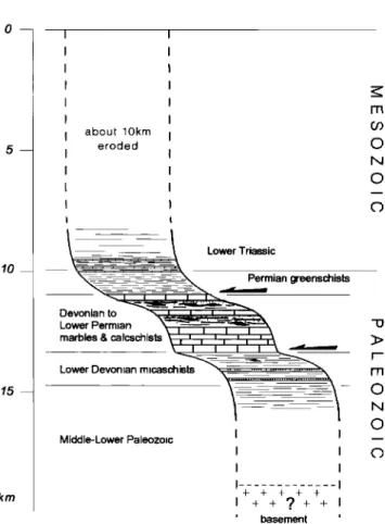
614 LACASSIN ET AL.: TERTIARY DEFORMATION SE OF TIBET 10 15 km about 10km eroded
•
Lower
Triassic
•,.•'•'•'••'--•-'•-
Permian
greenschists
Devonian to '•...•.•:.• .... Lower Permian '•= '" . I I I Imarbles&calcsch•sts%
i , • • i , i ,1%
Lower
Devonian
micaschist
...
Middle- Lower Paleozoic I Ii i i i i i + + + + + I + + ?+ + I ß ' basement '
Figure 9. Sketch of Mesozoic Paleozoic stratigraphy show- ing location of Yulong Shah bedding-parallel shear zones.
From greenschist grade of metamorphism, shear is inferred to have occurred at depth of the order of 12 to 15 km. A _>10 km thick pile of Mesozoic rocks, probably tectonized and thick- ened, stood above sheared middle/upper Paleozoic rocks.
graphic succession in the mountains north and south of Hu Tiao gorge. The 100-meter-scale parasitic folds, exposed at --4000 m asl in the marble cliffs on either side of the gorge (Figure 5a), could also result from upward ramping rather than disharmonic strain near the antiform axis, but our fieldwork is insufficient to prove or disprove either inference. The steep reverse faults along the western flank of Yulong Shan (Figure 2), if shown to exist, would correspond to later thrusts, proba- bly coeval with antiformal folding of the dficollement.
3. Rb-Sr Dating of Tectonics and
Metarnorphism in the Tiger-Leap Gorge
3.1. Sample Description and Dating ConceptTo determine the age of greenschist metamorphism and deformation in the rocks of the Yulong Shan dficollement, a phlogopite-rich marble (YN-75) was collected at the base of the marble series in the gorge, near He Tao Yuan (Figure 5). This rock is composed of alternating layers of white calcite and white, yellowish to salmon-pink micas that occur in different proportions and varying thickness. The mica flakes are oriented parallel to this lithologic banding, having grown within the foliation planes. Because of this strictly bimodal mineralogical composition between calcite matrix and mica,
a conventional approach for Rb-Sr dating was not possible, and an attempt was made to determine the age by a mica-
internal isochron using different mica-size fractions. This
technique has been used for U-Pb dating on accessory min- erals, the assumption here being that small and large micas might have formed with different Rb/Sr ratios reflecting early
or late stages of growth from domains with time-dependent
variations of the Rb/Sr ratio. Such changes in parent-daughter
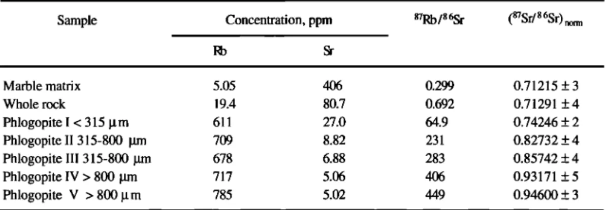
element ratios were assumed to be caused by fluid diffusion in association with metamorphism and deformation and by metamorphic reactions producing the banded marble. Potentially, such variation ought to be relatively easy to detect in mica, because this mineral is very rich in Rb and poor in Sr compared to the marble matrix and even very minor Sr exchange drastically modifies the Rb/Sr ratio. As listed in Table 1, such exchange is in fact demonstrated by the Rb and Sr concentrations measured in five different mica fractions, the whole rock, and the matrix. The values document exceptional Rb/Sr fractionation between the rock and its micas, confirming that the ratio must be, as suspected, grain- size dependent.
3.2. Rb-Sr Dating Results
All phases analyzed (Table 1) were selected from a sample of marble (YN-75, Figure 5), weighting about 2 kg and showing well-defined calcite-phlogopite layering. The mica layers consist almost exclusively of phlogopite flakes oriented parallel to that layering, i.e., to the foliation plane of the rock. The whole rock analysis (submicron powder) was obtained from a representative split including marble matrix and micas, whereas the matrix was selected from a homogeneous calcite layer in between two mica layers. The different phlogopite size fractions were separated from the total mass of phlogopite available in the cube. Figure 11 shows the isochron diagram for the seven different analyses performed, defining a linear regression line that corresponds to an age of 35.9 + 0.3 (2c•) Ma. Although the data show a slight scatter along this
isochron ({j2re
d = 5.8; mean square weighted deviate
(MSWD) = 23), the regression is of sufficient quality to interpret the 35.9 Ma age as that of metamorphism, i.e., of mica growth in equilibrium with formation of the marble. The slight scatter can be ascribed either to very local disequi- librium conditions (small variation in initial Sr isotopic com- positions at the centimeter scale) or to later weak Rb-Sr exchange between matrix and micas. Such small postcrystal- lization changes in Rb/Sr would be strongly enhanced by the extreme contrast, as mentioned above, of Rb and Sr concen- trations between matrix and micas (Table 1). The lowest Rb and highest Sr abundance is measured in the calcite matrix (5 and 406 ppm, respectively), whereas the largest phlogopites show an exactly inverse pattern (785 and 5 ppm, respec- tively). It is this exceptional contrast that allows us to deter- mine a precise age by a mineral-internal Rb-Sr isochron, as demonstrated here for the first time. Up to now, mineral isochrons have mostly been derived from analysis of different minerals in the same rock, not size fractions of the samemineral.
Since the average local temperatures during the metamor- phic event are unlikely to have reached the closure tempera- ture of Rb-Sr in white mica (= 500øC), the 35.9 Ma age can unambiguously be interpreted as the age of phlogopite crystal-
LACASSIN ET AL.' TERTIARY DEFORMATION SE OF TIBET 615 N o o o o o o •,o %0 0 \ / o o ,
•/ , "!•-"
';;'
\ . Downstream N o o o o ß / / .,, Upstream ./ / / N ø o o o .-....•.., o o o• o ø,goO o;:n..'
.r.'. q- ß
ß
'. ß
.-
ß m_ ß ß / ß / / o // ooøo
i before •
• rotation
i
after rotationß foliation pole
o lineation from E and W flank
ß lineation from Yulong core
[] mean foliation poles (up & down stream)
[] rotation axisFigure 10. Restoration of shear direction on ductile d6collement before antiformal folding. (a) Data cor- responding to eastern flank of antiform (downstream part of the gorge, circled D on Figure 3). (b) Data corresponding to western flank of antiform (upstream part of the gorge, U on Figure 3). (c) Data from both flanks before rotation. (d) After rotation of 45 ø (downstream data) and 90 ø (upstream data), about antiform axis (shaded square). Lineations are restored to mean N40øE direction. Unrotated lineations from Yulong core (gently dipping foliations) strike --N10øE, thus closer to N-S (Figure 8). Transport was to SW to SSW in present-day coordinates.
lization and growth during the greenschist facies metamor- phism that accompanied SW to SSW directed shear on the ductile d6collement (Figure 12a).
4. Insight on the Cooling History From
•Ar/4øAr Feldspar Dating
In order to put additional constraints on the metamorphic and cooling history of the Yulong Shan, we attempted to date K-feldspars extracted from one sample of quartzo-feldspathic
micaschists,
using the 39Ar/nøAr
technique.
This sample
(YU-
85) comes from a zone affected by minor refolding of the bedding/foliation planes in the core of the antiform (Figure 5). It is made of alternating light and dark grey layers bearing mainly quartz-feldspar and biotite, respectively. Using heavy liquids, 14.43 mg of K-feldspar of fraction size between 250 and 150 !.t m were separated from the whole crushed sample. Under binoculars, these feldspars appeared of poor quality with irregular and composite grains. They were irradiated in the Ford reactor, University of Michigan, at position L67 for 45 hours in the same tube as Fish Canyon sanidines (FC-3), pure K2SO 4 crystals, and CaF 2 salts. Argon isotopes liberated
616 LACASSIN ET AL.' TERTIARY DEFORMATION SE OF TIBET
Table 1. Rb-Sr Analytical Results for Different Size Fractions of Phlogopite From Marble Sample YN-75
Sample
Concentration,
ppm
a7Rb/8
6Sr
( 87Sr/8
6Sr)
norm
Marble matrix 5.05 406 0.299 0.71215 + 3 Whole rock 19.4 80.7 0.692 0.71291 + 4 Phlogopite I < 315 [tm 611 27.0 64.9 0.74246 + 2 Phlogopite II 315-800 grn 709 8.82 231 0.82732 + 4 Phlogopite III 315-800 grn 678 6.88 283 0.85742 + 4 Phlogopite IV > 800 pm 717 5.06 406 0.93171 + 5 Phlogopite V > 800 gm 785 5.02 449 0.94600 + 3
The (878r/86Sr)norm
is normalized
to 86Sr/88Sr
= 0.1194. Analytical
uncertainties
are + 2% for 87Rb/86Sr,
and
for (878r/86Sr)norm,
they
are given
in table
1, on the last
digit
of the values
measured.
Replicate
analyses
of National
Bureau
of Standards
(NBS) 987 Sr standard
yielded
a value
of 0.71025
+ 3 for (878r/86Sr)norm
during
the period
of analytical
work.
The 8?Rb
decay
constant
used
is 1.42 x 10
4•/year
[Steiger
and
J•iger,
1977]. Rb/Sr were determined by the isotope dilution method using a mixed 84Sr/85Rb spike added to aliquots of the solution, whereas whole rock and matrix analyses were spiked totally prior to dissolution.
Prior to dissolution, all micas were washed at about 40øC in 1N HC1 for about 20 min.
by these feldspars under progressive step heating were mea- sured in the mass spectrometer of the University of Clermont Ferrand. The J factor calculated assuming an age of 27.8 Ma for the fish Canyon sanidines [Miller et al., 1985] is 0.0074.
Analysis of the m2so 4 crystals and CaF2 salts yields
(39Ar/4øAr)K, (39Ar/37Ar)Ca, and (36Ar/37Ar)Ca correction
factors of 0.021, 0.0007, and 0.00025, respectively. Results are given in Table 2.
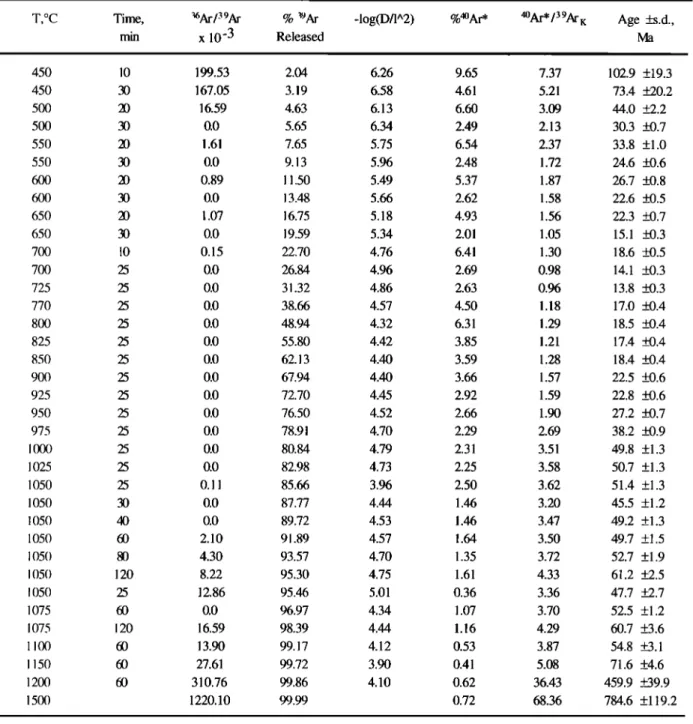
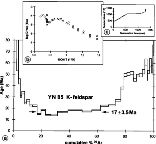
The resulting age spectrum (Figure 13a) shows decreasing
ages in the first 20% of 39Ar release. The steps between 20%
0.9
0.8
0.7
phlogopite marble (YN-75)
35.9 + 0.3 Ma (2
Sr
i - 0.71199
+ 2
phlog /// phlog II phlog IV phlog Iwhole rock and matrix
2
- 5.8 red
0 100 200 300 400 500
87Rb186Sr
Figure 11. Mineral-internal Rb-Sr isochron resulting from analysis of different size fractions of phlogo- pites, matrix, and whole rock (marble sample YN-75). Phlogopite crystallization within foliation planes occurred at 35.9 + 0.3Ma (2c• error). Initial 87Sr/86Sr ratio was 0.71199. :
LACASSIN ET AL.' TERTIARY DEFORMATION SE OF TIBET 617
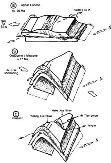
• upper
Eocene
"-- 36 Ma Folding in 2/,// I
ssw
'"--- J•'. /
i/t•/l •
••'.•:•.:• ' •
O igocene / Miocene -,-17 Ma shortening7
Haba Xue Shan
piQ Yulong
resentXue
Shan••'••
He
Tiao
gorge
'" Yangzi
Figure 12. Sketch showing inferred evolution of Yulong Shan Range (see discussion in text). (a) Eocene (-- 36 Ma) trans- port toward SSW on bedding-parallel ductile d•collement. (b) Miocene (= 17 Ma) antiformal folding of d•collement with fold axis oblique to former shear direction. Main uplift and erosion of the range, together with incision by Jinsha Jiang and formation of Hu Tiao "cluse", are inferred to have occurred during folding, resulting in (c) present geometry.
and 68% of argon release define a rough plateau, from which an age of 17 + 3.5 Ma (2c•) may be calculated. The highest temperature steps (last 20 % of Argon release) are grossly aligned on an even rougher plateau between 48 and 51 Ma. On the corresponding Arrhenius diagram (Figure 13b), the lower temperature steps define a curve with a concave shape and wide separations between successive isothermal heatings. In contrast with what is observed with most K-feldspars, whose progressive argon release may be modeled assuming a dis- crete distribution of domain sizes for argon [Harrison et al., 1991; Lovera et al., 1991], it was impossible here to calculate a model fitting the Arrhenius diagram. Thus we could not retrieve any detailed cooling history from YN85 results. Note that metamorphism reached greenschist facies conditions only; hence temperatures too low to permit crystallization of new K-feldspars. It follows that the analyzed K-feldpars were probably inherited sedimentary grains that suffered Argon loss
during Tertiary metamorphism. The usual heating procedure for 39At/4øAt analysis of K-feldspar (Figure 13c), which starts
at 450øC, was probably inadequate to precisely unravel the
Tertiary thermal history of those feldspars. However, it is pos-
sible to interpret the age spectrum of YN-85 as a composite
age spectrum. The older, rough plateau around 50 Ma could
testify to partial argon loss at the time of peak metamorphism (--36 Ma according to the Rb/Sr age of YN-75 phlogopites). The better defined, younger plateau most probably corresponds
to a phase of rapid cooling sometime between 15 and 20 Myr
ago (17 + 3.5 Ma).
5. Summary and Discussion
Our structural study of the Yulong $han and the radiometric dating of minerals in its core indicate that motion (in present geographical coordinates) on a flat ductile d•collement took place in the late Eocene in the region of Yunnan closest to the Tibetan highlands. That d•collement, localized within Devonian and Carboniferous micaschists and marbles (Figure 9), transported a •10-km-thick pile of mostly Mesozoic rocks a few tens of kilometers toward the SSW, relative to lower Paleozoic sediments series and Precambrian basement under- neath (Figure 9). Other d6collement zones probably existed at shallower or deeper levels in the crust. The moderately de- formed lower-middle Paleozoic micaschists and gneisses, with SSW directed lineations and shear senses, found along the Judian-Weixi section about 70 km east of the Yulong Shan [Leloup et al., 1995], probably correspond to such deeper d•-
collement zones.
It seems likely that kilometer-thick zones of strongly sheared rocks, like those found in the Yulong Shan (Figure 9), are of regional extent and significance. We thus interpret the Yulong Shan d6collement, and the ramp thrusts splaying upsection from it (Figure 12)., to result from collisional shortening of the sedimentary cover of the Yangzi platform, due to the penetration of India into Asia. This d•collement and possibly deeper ones probably linked midcrustal strain with folding and thrusting of the overlying sediments, thus acting as basal flats underneath a detached fold and thrust belt [Boyer and Elliott, 1982]. It probably rooted on a deep crustal ramp
located northward near the border between Sichuan and Tibet.
The metamorphism coeval with such thrust transport (35.9 +0.3 Ma) is only slightly older than the earliest anatectic melts (35.0 + 0.1 Ma) dated along the Ailao Shan-Red River shear zone to the south [Schi•rer et al., 1994]. Thus transport on the Yulong Shan d•collement and related regional overthrusting appears to have been synchronous with the early stages of sinistral motion along this zone.
All models of Asian Tectonics predict large clockwise (CW) rotations in the area located near the eastern Himalayan syntaxis and between the Ailao Shan-Red River and Xianshuihe sinistral fault zones (Figure la and lb). CW rotations of about 50 ø have been found in Cretaceous red beds of that area [Funahara et al., 1992, 1993' Huang Kainan and Opdyke, 1993]. It follows that late Eocene transport on the d•collement and the related shortening of the overlying series may have been oriented toward the south or south-southeast.
There is growing evidence that other large d•collements underlie the sedimentary cover or upper crust of regions surrounding the Eastern Himalayan syntaxis and other parts of
61 g LACASSIN ET AL.: TERTIARY DEFORMATION SE OF TIBET
Table 2. The 39Ar/4øAr
Analytical
Results
for K-feldspar
From Sample
YN-85
T,øC
Time,
36Ar/3
9Ar
% 39Ar
-log(D/l^2)
%4øAr*
min
x 10-3
Released
4OAr,/39Ar
K
Age +s.d.,
Ma 450 10 199.53 2.04 6.26 9.65 450 30 167.05 3.19 6.58 4.61 500 20 16.59 4.63 6.13 6.60 500 30 0.0 5.65 6.34 2.49 550 20 1.61 7.65 5.75 6.54 550 30 0.0 9.13 5.96 2.48 600 20 0.89 11.50 5.49 5.37 600 30 0.0 13.48 5.66 2.62 650 20 1.07 16.75 5.18 4.93 650 30 0.0 19.59 5.34 2.01 700 10 0.15 22.70 4.76 6.41 700 25 0.0 26.84 4.96 2.69 725 25 0.0 31.32 4.86 2.63 770 25 0.0 38.66 4.57 4.50 800 25 0.0 48.94 4.32 6.31 825 25 0.0 55.80 4.42 3.85 850 25 0.0 62.13 4.40 3.59 900 25 0.0 67.94 4.40 3.66 925 25 0.0 72.70 4.45 2.92 950 25 0.0 76.50 4.52 2.66 975 25 0.0 78.91 4.70 2.29 1000 25 0.0 80.84 4.79 2.31 1025 25 0.0 82.98 4.73 2.25 1050 25 0.11 85.66 3.96 2.50 1050 30 0.0 87.77 4.44 1.46 1050 • 0.0 89.72 4.53 1.46 1050 60 2.10 91.89 4.57 1.64 1050 80 4.30 93.57 4.70 1.35 1050 120 8.22 95.30 4.75 1.61 1050 25 12.86 95.46 5.01 0.36 1075 60 0.0 96.97 4.34 1.07 1075 120 16.59 98.39 4.44 1.16 II00 60 13.90 99.17 4.12 0.53 I 150 60 27.61 99.72 3.90 0.41 1200 60 310.76 99.86 4.10 0.62 1500 1220.10 99.99 0.72 7.37 102.9 +19.3 5.21 73.4 +__20.2 3.09 44.0 +2.2 2.13 30.3 __+0.7 2.37 33.8 +1.0 1.72 24.6 __-+0.6 1.87 26.7 __+0.8 1.58 22.6 __+0.5 1.56 22.3 __+0.7 1.05 15.1 __+0.3 1.30 18.6 __-+0.5 0.98 14.1 __+0.3 0.96 13.8 __+0.3 1.18 17.0 __-+0.4 1.29 18.5 __-+0.4 1.21 17.4 __-+0.4 1.28 18.4 __-+0.4 1.57 22.5 •.6 1.59 22.8 __+0.6 1.90 27.2 __+0.7 2.69 38.2 __+0.9 3.51 49.8 +1.3 3.58 50.7 +1.3 3.62 51.4 +1.3 3.20 45.5 +1.2 3.47 49.2 +1.3 3.50 49.7 +1.5 3.72 52.7 +1.9 4.33 61.2 +2.5 3.36 47.7 +2.7 3.70 52.5 +1.2 4.29 60.7 +3.6 3.87 54.8 +3.1 5.08 71.6 +4.6 36.43 459.9 +__39.9 68.36 784.6 +119.2* The 4{•Ar* corresponds to radiogenic argon.
Tibet. Tapponnier et al. and Meyer [Tapponnier et al., 1990b;
Meyer, 1991], for instance, have inferred the numerous, paral- lel active thrusts of the Qilian Shan, on the northeastern edge
of Tibet, to root into such a crustal-scale ddcollement. North
of the Lijiang mountains, in the Songpan Garze region (Figure
14a), another large-scale ddcollement with transport toward
the south appears to lie the base of a thick pile of folded
Triassic flysch and Paleozoic sediments [Mattauer et al., 1992; Calassou, 1994]. As Upper Triassic granites intrude folds at places, motion on the ddcollement has been inferred to be mostly Triassic in age [Mattauer et al., 1992]. Ductile shear on
this d•collement and the associated metamorphism, however, have not yet been dated, and it is plausible that part of the transport occurred during the Tertiary. Farther SE, within
Indochina (Figure 14a), a Tertiary phase of--N-S shortening affects the Khorat Mesozoic series [Mouret, 1994], and pos-
sibly also the northwestern mountainous part of Vietnam, where present-day elevations exceed 3000 m and Cretaceous red beds are commonly folded (Annam, Black-River, and Tonkin ranges). Restoring about 700 km and 300 km of left- lateral displacements on the Red River and Xianshui He Fault
LACASSIN ET AL.: TERTIARY DEFORMATION SE OF TIBET 619
3
I
/
o
• -s -i- o øo I E •' / 8 • Iv- ol , , , "- / • I • 0 500 1000 150080 - .7!6
I
3o
YN 85 K-feldspar
2O, ,
17
+3.5Ma
10 -- 0 I I I I1•) 0
20
40
60
80
100
cumulative % 3•ArFigure 13. The 39Ar/4øAr analysis of K-feldspar extracted from sample YN-85 (quartz-feldspar bearing
micaschist). (a) Age spectrum. Rough plateau yields age of 17 + 3.5 Ma (20 to 68% of Ar release). Last 20% of Ar release defines rougher plateau between 48 and 51 Ma. (b) Arrhenius diagram. (c) Heating procedure, starting at 450øC, used for analysis.
Zhenyu and Besse, 1993; Leloup et al., 1995], would place those ranges in rough continuity with the Yulong Shan and Songpan-Garze (Figure 14b). The location of these regions would therefore have been adequate for significant N-S short- ening of the Asian crust to occur north and northeast of the Indian front, in the early stages of collision but mostly prior to the onset of Indochina's extrusion (Figures 14a and 14b). Such shortening perhaps reactivated older crustal thrusts and suture zones separating the different blocks of northern Tibet [Seng6r andHsii, 1984]. The reconstruction of figure 14b thus implies that a south verging thrust belt existed north and NE of Tibet in the lower-middle Tertiary. The thick unconformable mid- upper Eocene molasse found at several localities of north- western Yunnan, southeastern Sichuan and eastern Tibet [Bureau of Geology and Mineral Resources of Yunnan, 1983; Jiao Shupei et al., 1988; Wang and Chu, 1988; Leloup et al.,
1995], and intruded by monzonitic rocks dated at 35Ma near Jianchuan [Schfirer et al., 1994], might result from the erosion of the corresponding relief.
For the most part, large-scale sinistral motion on the Ailao Shan-Red River shear zone, dated between 35 Ma and =17 Ma [Schiirer et al., 1990; Harrison et al., 1992; Leloup et al., 1993; Schfirer et al., 1994], appears to postdate this early phase of shortening. As strain became localized along that large strike-slip shear zone, at rapid slip rate (3-4 cm/yr)
[Leloup et al., 1995], the direction of regional shortening shifted to =E-W, consistent with transpressive folding of the red beds in adjacent basins. This second shortening phase, which is in part coeval with left-lateral movement, is best documented in the red bed basins of Yunnan but is ubiquitous accross both Sundaland and South China (Figure 14a). We infer anticlinal doming of the Yulong Shan to be related to that second phase of Tertiary shortening, as most of the folding of the Mesozoic red beds of the Chuxiong and Simao basins (Figures 12, 14a, and 14c). Since antiformal doming of the Yulong Shan postdates transport on the Yulong ddcolle- ment, the corresponding E-W shortening phase must postdate
35 Ma. The 39Ar/4øAr age spectra of K-feldspar would be
consistent with cooling, plausibly related to the antiformal uplift, and concurrent denudation by erosion, of the Yulong core, at -- 17 Ma. The well-preserved antiformal shape and positive relief and the fact that the course of the Jinsha river is antecedent to the growth of that great fold (Figure 12) imply anabated folding well into the late Miocene. Such folding must have ceased before the onset of the current regime of =E-W extension, around 5 Ma [Leloup et al., 1993], which probably created the recent normal faults bounding the eastern flank of the Yulong Shan (Figure 3 and 4).
Elsewhere [Leloup, 1991; Leloup et al., 1995], we have inferred Tertiary d6,collements similar to that now exhumed in
620 LACASSIN ET AL.' TERTIARY DEFORMATION SE OF TIBET
100 ø E
TIBET
30 ø N
\ 110;E
•,•
D6collements
&
thrusts
Shortening phase 1 towards S or SSW
Shortening
phase
2
D6collements
towards E or ESE& thrusts
/ • .. • •-
I?'"
I
I
• ?•
Mid
to
late
Eoce•
• /
• ,,/:'•(a•,nd
Southward40-
•rusting35
Ma)
•'•• and d•collement
ASIA
., •" 5•' :.•:• ') • .•
Oilgo - Miocene
•
and d•collementEas•a,
•msfing
Figure 14. Regions affected by Cenozoic shortening east of Himalayas and Tibet. D6collements, compa-
rable to that exhumed in Yulong Shan, are inferred to underlie fold and thrust belts visible at surface.
Motion on d6collements was nearly perpendicular to fold axes. (a) Sketch map showing possible extension of, and transport direction on, regional Cenozoic d•collements (see discussion in text). Faults with open triangles correspond to probable location of crustal thrust ramps corresponding to phase 2 shortening. (b) Speculative geometry and location of mid to late Eocene d•collements and thrusting toward the south in
framework of India-Asia collision. Shortening is inferred to have occurred north and northeast of Tibet at this
time, possibly in connection with right lateral motion on Dien Bien Phu Fault zone. Abbreviations are RRF, Red River Fault; WCF, Wang Chao Fault; IND, lndochina. (c) Speculative geometry and location of Miocene to Pliocene-Quaternary d•collements, underlying folded regions of South China and NW
Indochina.
the Yulong Shan, but with transport mostly toward the east, to underlie the Mesozoic sandstones of the Simao, Chuxiong and Sichuan basins and to be structurally related to the roughly N- S anticlines in those basins (Figure 14a). From the inferred 17 Ma uplift age in the Yulong Shan we infer that, at least north of the Ailao Shan-Red River shear-zone, =E-W shortening may have accompanied the end of Indochina extrusion.
Shortening and transport toward the east, seem to have taken place over a wide area east of the Tibet and Shan plateaus, encompassing northwestern Thailand in the south and much of the Yangzi platform and Sichuan basin in the
north (Figure 13a and c). At the scale of that area (--2 10 6
km2), it seems likely that such shortening was diachronous,
possibly in tune with the northward motion of India. It might have occurred earlier in NW Thailand, for instance, coeval with the late stages of sinistral motion on the Wang Chao Fault around 30 Ma [Maluski et al., 1993; and R.Lacassin et al., manuscript in preparation, 1996], than farther north. Roughly E-W shortening still takes place in Sichuan with d•collements and ramp thrusts underlying the folded Yangzi
belts as well as the Lungmen Shan. Much more chrono logical evidence will be needed to establish the exact timing of crustal shortening phases over such a vast area. Nevertheless, the northward diachronism of the onset of E-W shortening and of east directed transport in regions located on the east side of the Indian indenter seems as inescapable a consequence of the northward penetration of India into Asia, as the succi•ssive extrusion of large continental blocks located farther and farther north on that side has proved to be [Tapponnier et al., 1986; Peltzer and Tapponnier, 1988; Lacassin et al., 1995; Leloup et al., 1995]
Acknowledgments. Fieldwork in the Yulong Shan was performed in 1991, during the Hong He - Jinsha Jiang cooperative program be- tween the Centre National de la Recherche Scientifique (CNRS), the National Science Foundation of China, and Academia Sinica. This project was directed in China by Zhong Dalai who is gratefully acknowledged. We thank L. Ratschbacher, P. Copeland and K. Burke for constructive reviews and suggestions. J.R. Kienast helped us to as- sess the metamorphic grade of the Yulong micaschists. Guy Aveline is responsible _for the quality of figures. This is I.P.G.P. contribution 1418.
![Figure 2. Simplified geological sketch map of Yulong Shan, modified after 1'500,000 geologic map of Yunnan [ Geological Bureau of Yunnan Province, 1979]](https://thumb-eu.123doks.com/thumbv2/123doknet/14737431.575003/5.915.215.717.109.724/figure-simplified-geological-yulong-modified-geologic-geological-province.webp)