HAL Id: hal-02756929
https://hal.inrae.fr/hal-02756929
Submitted on 3 Jun 2020
HAL is a multi-disciplinary open access
archive for the deposit and dissemination of sci-entific research documents, whether they are pub-lished or not. The documents may come from teaching and research institutions in France or abroad, or from public or private research centers.
L’archive ouverte pluridisciplinaire HAL, est destinée au dépôt et à la diffusion de documents scientifiques de niveau recherche, publiés ou non, émanant des établissements d’enseignement et de recherche français ou étrangers, des laboratoires publics ou privés.
What are farmers’ development options in the context of
páramo conservation ? A case study from Colombia
Ophélie Robineau, Martin Châtelet, Isabelle Michel, Christophe-Toussaint
Soulard, Joshua Posner
To cite this version:
Ophélie Robineau, Martin Châtelet, Isabelle Michel, Christophe-Toussaint Soulard, Joshua Posner. What are farmers’ development options in the context of páramo conservation ? A case study from Colombia. ISDA 2010 Innovation and Sustainable Development in Agriculture and Food, Jun 2010, Montpellier, France. �hal-02756929�
W
HAT ARE FARMERS
’
DEVELOPMENT OPTIONS
IN THE CONTEXT OF PÁRAMO CONSERVATION
?
A
CASE STUDY FROM
C
OLOMBIA
Ophélie ROBINEAU*, Martin CHÂTELET*, Isabelle MICHEL-DOUNIAS**, Christophe-Toussaint SOULARD***, Joshua POSNER****
* Institut des régions chaudes, Montpellier SupAgro 1101 av. Agropolis, 34093 Montpellier, France
robineauophelie@gmail.com, martin.chatelet@gmail.com
** Institut des Régions Chaudes Montpellier SupAgro, and UMR 951 Innovation Campus de Lagaillarde, 2 place Viala, 34060 Montpellier, France
isabelle.michel@supagro.inra.fr *** INRA UMR 951 Innovation
Campus de Lagaillarde, 2 place Viala, 34060 Montpellier, France
soulard@supagro.inra.fr
**** Wisconsin University, Department of Agronomy 1575 Linden Drive, Madison, United States of America
jlposner@wisc.edu
Abstract — Although the Colombian environmental policy is unfavorable to farming in the páramo
ecosystem, it is believed that an integrated management of the páramo is possible, and that farming activities can be part of the solution at this agriculture-environment problem. This issue has become particularly acute on the Rabanal páramo (western cordillera) where the projected expansion of a core protection zone will soon include major areas used for agriculture and settlements. In this paper, we show how a multi-scale approach combining agronomy, geography and management sciences, can help to identify areas of flexibility within the páramo farms for the introduction of technical and organizational changes that combine conservation and sustainable livelihoods. A study of local agrarian history and aerial photos indicates that this zone has been a dynamic part of local farming systems since at least the 1950’s and that the páramo has evolved from a subsistence farming area to a zone that now includes intensive potato production conducted by external entrepreneurs. The presence of entrepreneurs is mainly due to the need of family farmers for a solution to maintain the productivity of their pastures. Through a process of interviewing participants in the debate, as well as mapping land use in the contested area, perspectives for action were developed that would result in more sustainable farming practices.
Key words : páramo, integration agriculture-environment, farming system, typology, logic of land
use, geo-agronomy
Résumé — Quelles capacités d’adaptation des agriculteurs dans un contexte de conservation d’un
páramo ? Bien que les politiques environnementales colombiennes soient contre la présence d’activités agricoles sur les páramos, la présente étude considère qu’une gestion intégrée de ces écosystèmes est possible, et que les activités agricoles sont porteuses de solutions dans ce problème d’intégration agriculture-environnement. Cet enjeu est devenu central sur le páramo Rabanal (cordillère orientale), où l’expansion de l’aire protégée centrale inclura bientôt des zones cultivées majeures. Dans cet article, l’intérêt d’une approche multi-scalaire combinant agronomie, géographie et sciences de gestion, afin d’identifier des aires de flexibilité pour l’introduction de changements techniques et organisationnels dans les fermes permettant de combiner conservation et développement local durable, est mis en avant. Une étude de l’histoire agraire locale et de photographies aériennes souligne que l’évolution des activités agricoles dans cette zone fut dynamique depuis les années 50 et que le páramo a évolué d’une zone d’agriculture de subsistance à une zone où se met désormais en place une culture intensive de pomme de terre, produite par des entrepreneurs agricoles. Leur présence est principalement due à la nécessité des agriculteurs familiaux de maintenir la productivité de leurs pâturages. A travers un processus d’entretiens avec les acteurs locaux et la cartographie de l’utilisation du territoire depuis l’échelle parcellaire à celle du páramo, des perspectives d’actions pour la mise en place de pratiques plus favorables à la conservation du páramo furent identifiées.
Mots clés : páramo, intégration agriculture-environnement, systèmes de production, typologie,
logique d’utilisation du territoire, géo-agronomie
Acknowledgment
The results presented in this article have been published in the international, peer-review open access journal Mountain Research and Development (Volume 30 No 3, August 2010).
The research was conducted thanks to grants from the Proyecto Páramo Andino and from the Institut des Régions Chaudes of Montpellier SupAgro. It was supported locally by the Colombian Research Institute Alexander von Humboldt (IAvH). The two field researchers are grateful to the IAvH for its help and support: Carlos Tapia, Adriana Vasquez, Tatiana Menjura, Maria Isabel Vieira, Maria Antonia Espitia, Diana Duque Marin, Maria Paula Quiceno. They also thank all the páramo farmers of vereda Firita Peña Arriba, especially Campo Elias and Martina, Florencio, Isidro and Maria, Feliz and Flor, Salustinao and Ana Olga, Florinda and Helena.
1. PÁRAMO CONSERVATION, A CENTRAL ISSUE IN THE ANDES
Protected areas such as national parks and reserves now cover more than 12% of the world's land area (Chape et al 2003). However, as the United Nations convened Rio conference (1992) highlighted, due to the failures of strict protection policies, it is crucial that there remain close links between environment and development policy (IUCN/UNEP/WWF 1991). Nevertheless, the viewpoint “protection versus development” remains a contentious element in the analysis of protected areas (Héritier 2007). This is perhaps not surprising as integrated landscape planning, making specific choices about land use, wildlife protection, and resource development that are acceptable to communities and conservation authorities remains a difficult task (Slocombe 1993).
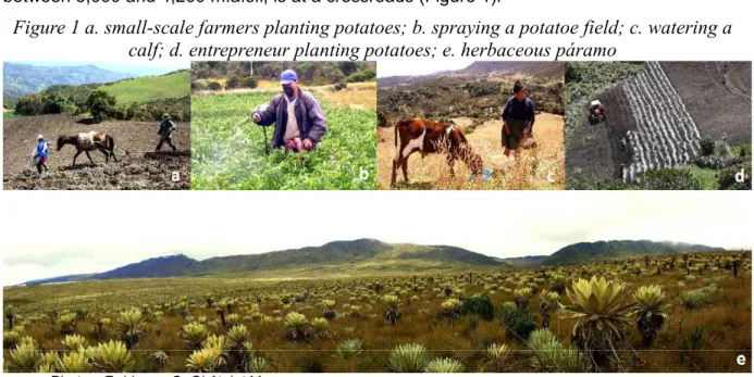
In this context, the Andean páramo, a unique mountain grassland ecosystem located between 3,000 and 4,200 m.a.s.l, is at a crossroads (Figure 1).
Figure 1 a. small-scale farmers planting potatoes; b. spraying a potatoe field; c. watering a calf; d. entrepreneur planting potatoes; e. herbaceous páramo
Photos: Robineau O, Châtelet M
While simultaneously its role in biodiversity conservation, water regulation, and carbon storage is growing more valuable (Van der Hammen 2002), there is an increasing demand for potatoes and milk production. For decades, on most of Colombian páramo, potato and dual-purpose cattle production have been the main stay of family farms. More recently, there has been an expansion of an alternative system where the land is rented for a year for capital-intensive potato production followed by several years of grazing. However, this newer system is in direct confrontation with national environmental policy. Increasingly, policy is unfavorable to farming in this ecosystem and is centered on the creation of protected areas free from productive activities.
In the tropical Andes, many researchers have focused on the ecology and on human-induced ecological effects on these high-altitude tropical grasslands (Etter and Villa 2000; Cardenas and Vargas 2008). Hofstede (1995) has shown that the combination of grazing and burning reduces soil organic matter levels and increases soil bulk density, markedly reducing soil water retention capacity. More recently, other studies have been conducted to characterize the agricultural and settlement frontiers focusing on socio-economic aspects, hence providing new inputs for an integrated management of this fragile ecosystem. Lopez Sandoval (2004) working in the Ecuadorian páramo highlighted the complexity of the reasons for expanding or stagnating agricultural and settlement pioneer zones. Llambi et al (2005), working in the Venezuelan páramo, reported on the necessary implementation of a participatory planning to improve the conservation of the páramo by incorporating local communities in the land planning exercise. This implies a deep understanding of the páramo
What are farmers’ development options in the context of páramo conservation ? (Robineau O, Châtelet M, Michel-Dounias I, Soulard C, Posner J)
users’ objectives, particularly farmers’, put in parallel with the environmental objectives. However, little information is yet available on that topic in Colombia.
The objective of the field research presented in this article is to provide inputs to facilitate the negotiation between local communities and environmental authorities on the Rabanal páramo. It relies on the hypothesis that to enhance a dialogue between farmers and institutions, it is necessary to consider farmers' objectives and strategies. An analysis of the local farming systems was undertaken to highlight the drivers of land use changes, and to identify options for allowing farmers to remain in the páramo while simultaneously meeting environmental objectives.
2. CASE STUDY OF THE RABANAL PÁRAMO IN COLOMBIA
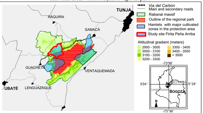
The Rabanal páramo is a pilot study area for the Global Environmental Fund (GEF) Andean Páramo Project. This project is lead by the Consortium for the Sustainable Development of the Andean Ecoregion (CONDESAN) and in Colombia, the lead agency is the Institute Alexander von Humboldt. The Rabanal páramo is located 100 km north of Bogotá (5°24'00 N latitude, 73°36'00 W longitude). This páramo was ch osen for inclusion in the project in part because the core protected area had been expanded from 2681 to 8600 ha in 2008 (IAvH 2008), and although this legislation had been largely ignored, current emphasis on enforcement would markedly affect páramo land management in the six villages that surround the zone (Figure 2).
Figure 2 Localization of the hamlet Firita Peña Arriba: among the four hamlets having major cultivated areas within the future regional park
Conception and design : Robineau O, Châtelet M
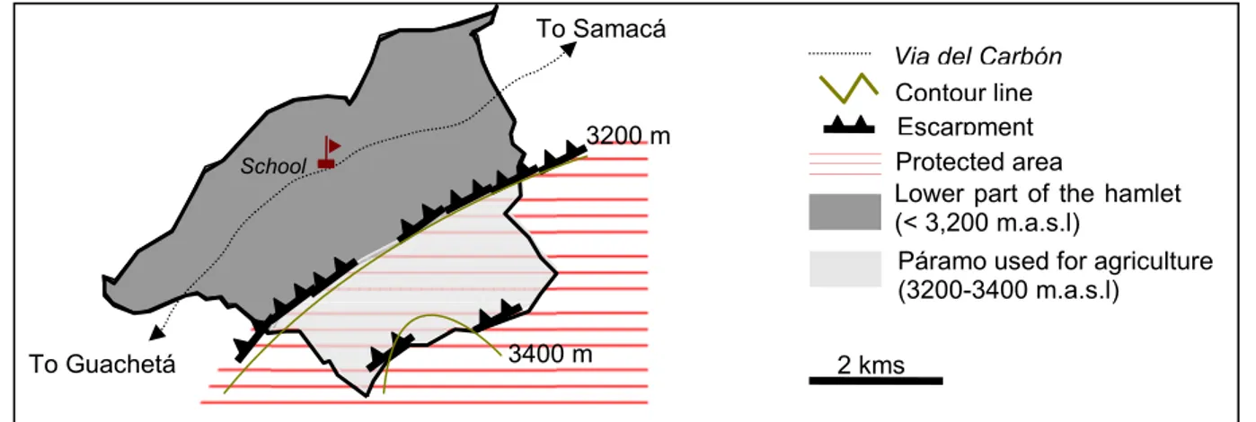
This study was conducted, in the hamlet of Firita Peña Arriba, in the township of Ráquira. It includes an area of 1,331 ha, of which 560 ha are now designated as part of the protected area outlined by the Rabanal management plan (IAvH 2008). The hamlet is divided into two parts:
1) A lower hilly part (below 3,200 m.a.s.l) home of 90% of the 434 hamlet’s inhabitants, that includes most of the village infrastructures and services and 27 coal mines;
2) The páramo area also used for agriculture (about 560 ha, above 3,200 m.a.s.l), and home of 10% of the population. This is the focal area of the study (Figure 3).
TUNJA UBATÉ LENGUAZAQUE GUACHETÁ RÁQUIRA SAMACÁ VENTAQUEMADA
Via del Carbón
Main and secondary roads
Altitudinal gradient (meters) Rabanal massif
Outline of the regional park
2900 - 3000 3000 - 3100 3100 - 3200 3200 - 3300 3300 - 3400 3400 - 3500 > 3500
Study site Firita Peña Arriba
CUNDINAMARCA BOYACA N -73°36' -73°36' 5° 24' 5°24 ' BOGOTA Hamlets with major cultivated zones in the protection area
Figure 3 Organization of the hamlet Firita Peña Arriba, Ráquira
Conception and design : Robineau O, Châtelet M
3. MATERIAL AND METHODS
A three step approach combining agronomy, geography and management sciences was followed to identify areas of flexibility for the introduction of technical and organizational changes that would promote combining the conservation of páramo biodiversity and water resources with sustainable livelihoods.
The core of the research was a spatio-temporal analysis of farming activities in order to understand the logic of land use: that is to say, why and how farmers use the páramo land. Spatial and temporal scales were considered, from the páramo to the cultivated parcel, and from the daily management of farming activities to the life cycle of a farm.
the first step consisted of key informant interviews with the objective of understanding the forces driving land use changes on the Rabanal Páramo from the parcel scale to the whole páramo area used for agriculture. A focus was made on the agrarian history of the study area. In parallel, geographical data in the form of aerial photos (Instituto Geográfico Agustin Codazzi, 1:24,000 scale, 1955, 1985, 2007) was gathered to identify the changes that occurred in the páramo landscape;
the second step was devoted to in-depth interviews with páramo farmers to understand the range of farm diversity and dynamics. Elements of the farming systems, notably the decision-making process for potato production, herd and pasture management, and economic data, were collected using semi-structured interviews. A typology of farmers was built, based on the strategies and objectives of the páramo agricultural users;
the third step was the identification of farmers' margins of maneuver for implementing more environmentally friendly farming practices. With the aid of a Global Positioning System (GPS), páramo fields were identified and mapped. A typology of parcels, based on the logic of land use, was built, which corresponds to a theoretical model of land occupation. Then propositions for modified land use that fit both the typology of parcels and farmers' strategies were developed.
Of the 35 users of the contested 506 hectares of páramo, intensive interviewing was conducted with 23 (each interview lasted for 2-4 hours, most were re-interviewed up to 3 times). It took a team of two people a six month period (May to October 2009) to collect the necessary information.
4. RESULTS
4.1. A brief history of agricultural use of the páramo
In the 1950s, the páramo landscape of Firita Peña Arriba was a mosaic of parcels within the native páramo vegetation. As opposed to the advance of a well delineated altitudinal frontier,
Via del Carbón
3400 m 3200 m
2 kms
Protected area
Lower part of the hamlet (< 3,200 m.a.s.l)
Páramo used for agriculture (3200-3400 m.a.s.l) Contour line To Samacá Escarpment School To Guachetá
What are farmers’ development options in the context of páramo conservation ? (Robineau O, Châtelet M, Michel-Dounias I, Soulard C, Posner J)
as Lopez Sandoval (2004) observed in her study in Ecuador, it does not appear to have been an altitudinal pioneer frontier but rather that over time the cultivated and grazed area within the already colonized páramo expanded (Figure 4).
The farm territories were divided into two sites, in the upper and lower part of the vereda. The cultivated area did not exceed 1 ha on the farm. Family farmers were mainly growing tubers on plots tilled by animal traction, with the help of their children who would eventually inherit the farm.
This traditional scheme was modified in the 1960s with the departure of many of the younger generation to work in the newly opened mines in the lower part of the vereda, and to the cities. Today there are 133 coal mines and 772 coke ovens in the region (IAvH 2008). As a result of this employment opportunity and migration to urban centers, nearly 40 % of the páramo land is in the hands of absentee owners and of miners. Some rent their land to the remaining family farmers and others developed low labor-intensive animal production to complement their non-farm income.
As a partial response to this loss of workforce, family farmers started to put more emphasis on dairy production and purchased Normandy dual purpose cattle in the 1970s. This activity requires less labor than potato production – the cattle are managed year round on meadows - and has progressively become the main source of income. However, the dairy cows in the herd require higher quality feed that is primarily found in new-growth pasture following potato production. This shift also coincided with increasing use of inputs (especially fertilizer) on potatoes enabling farmers to maintain, or even to increase, their tuber production despite the reduction of the area cultivated.
The maintenance of the forage quality of the pastures gradually became problematic. With now up to 5 milking cows and their progeny, and smaller and smaller areas sown to potatoes (due to the high costs of production), family farmers did not have enough higher quality pasture for their milk animals. However, in the 1980s a new solution presented itself. With the arrival of the Guatemalan potato moth (Tecia solanivora) to Colombia, agricultural entrepreneurs from the plains began looking for cooler, lower pest pressure páramo land to rent in order to produce potatoes on a large-scale. Páramo farmers started to rent-out parcels to these new arrivals as a way to solve their forage quality problems. Initially they benefited from the entrepreneurs' tractors to clear the rest of páramo vegetation on their farm to create more meadows, and then on a more regular basis, their pastures benefit from the tillage and residual effect of fertilizer inputs associated with this intensive large-scale potato production.
With the law 99 of 1993 (National decree 1713 of 2002) however, due to an increased focus on the role the Rabanal páramo played in potable and irrigation water provisioning, local environmental authorities tripled the size of the core protected area and threatened páramo farmers with fines for the land they had cleared. This strategy backfired and some farmers, afraid of losing their farm land still covered by páramo vegetation, quickly cleared them to affirm their property rights. More recently however, environmental authorities have become more determined to halt agricultural production in the expanded core area.
Figure 4 Evolution of the agricultural frontier over time in Firita Peña Arriba
Conception and design : Robineau O, Châtelet M
3150m 3400m 3400m 3150m 3150m
1955
1985
2007
Herbaceous and tree-scrub páramo Land cover Land use Cultivated area Humid high mountain evergreen forest Contour line Gravel road Streams Administrative boundaries of the hamlet Escarpment Dwelling Ancient dwelling Aerial photo 2nd escarpment 1st escarpment 1st escarpment 1st escarpment 2nd escarpment 2nd escarpment 3400mWhat are farmers’ development options in the context of páramo conservation ? (Robineau O, Châtelet M, Michel-Dounias I, Soulard C, Posner J)
4.2. Family farmers: central actors to the management of the páramo
Based on the surveys and farm mapping, three general types of páramo agricultural users were identified having different short and long term objectives that generate distinct impacts on the natural resource base: 1) active páramo family farmers, 2) miners and absentee land owners, 3) entrepreneurs from the plains. It is estimated that active family farmers manage approximately 60% of the páramo due to the land they own and rent on a long-term basis from absentee owners. In addition, about 75% of the 80 to 120 ha rented-out yearly to the entrepreneurs come from the family farms. For that reason family farmers are strategic actors for the management of the páramo.
4.3. Understanding land-use systems: 1) local farming practices
Family farmers live exclusively from farming activities and have farms of about 20 ha. Based on household budgets of 10 families, we estimate that their income of about 150 U$/month, well below the Colombian minimum wage (230 US$/month, Decree 4965 of 27-12-2007). The main economic activities of family farmers are dual-purpose cattle and potato production which contribute respectively to 60% and 25 % to their income. The remaining 15% of their income comes from marketing subsistence crops (maize, Andean tubers and broad beans) and land rental. This data suggests that the more important component of the land rental is not the income from the rent itself, but the positive impact the associated tillage and fertilizer additions have on subsequent forage productivity and quality.
4.3.1. Livestock farming system: core activity connected to the large scale potato production Livestock production remains the primary activity for family farmers on the páramo. They generally keep 10 to 12 heads of cattle, of which 5 are milking cows, and up to two-thirds of the 20 ha of the farm are devoted to grazing each year. The stocking rate does not exceed 1 animal unit per hectare. The main constraint páramo farmers face is the difficulty of maintaining forage productivity. They find that pastures need to be renovated every 3 to 4 years. But because of the small surface that farmers can cultivate in annual crops each year, they are not able to renew the pastures as rapidly as they feel is necessary. Hence, most of the potatoes grown on farmers' land are planted by commercial potato growers, to whom 5 to 7 ha is rented out yearly. This explains how small-scale livestock production is tightly linked with the large-scale potato production, which constitutes the main activity targeted by the environmental authorities.
Almost all their plots are part of the potato-pastures crop rotation: 1 year of potato (2 cycles) followed by 3 years of pastures. The logic of this rotation is: 1) to benefit from the positive carry-over affect of the potato production on pasture productivity and, 2) to maintain a period of time between replanting potatoes on the same plot in order to lower the pressure of soil-borne pests and diseases.
4.3.2. An intensive potato production
The land cultivated in potatoes is primarily on fields in the páramo area, rather than the lower village due to the larger fields and flatter terrain. In the lower site parcels are slopping and rocky, which makes cultivation and pasture renovation difficult: hence, a reallocation of activities to the lower part of the vereda (outside the limits of the future regional park), seems quite difficult.
Currently for 100 kg of tubers planted, which corresponds to 1000 square meters, 200 kg of chemical fertilizer, 200 kg of lime and 500 kg of poultry droppings are spread. Farmers consider it is essential to bring those quantities to ensure a minimum economic yield (25T/ha on commercial fields and 20 T/ha in farmers’ fields). They have a planning of systematic treatments to which they stick. Since growing potatoes is costly and risky, they do not want to take the risk of losing their production.
Somewhat surprisingly, family farmers in their small potato plot (rarely more than 0.2 ha, due to the high costs of production, and near the farmstead), follow nearly the same input schedule and the same cropping calendar. As the entrepreneurs, they do the soil tilling by tractor, with a disk plow.
However, the real difference between these two kinds of productions lies in the production scale: while familial potato production occurs on less than 5% of the expanded core area, up to 25% of this expanded area is cultivated annually by the entrepreneurs.
Clearly, dual-purpose cattle and potato production are two complementary sources of income and essential to balancing the family budget: while the regular sale of livestock product provides for the basic daily needs, family potato production brings more money at once and allows making investments.
4.4. Understanding land-use systems: 2) spatial organization, from the farm to the páramo scale
All páramo parcels are engaged in potato-pastures rotation but both the rotation’s duration and the surface planted in potato vary. The underlying logic of land use is related to the parcels characteristics, to the spatial organization of the farm territory and to the system of land tenure. A classification of fields was constructed based on farmers’ logic of land use, to approach spatially the environmental impact of agriculture. Mapping this typology is a good basis to settle a discussion between the stakeholders, formulate specific problems to be tackled and to start a negotiation. Three kinds of parcels were identified at the farm scale (Figure 5). It was thought that this would be an important site specific input to the process of designing new practices resulting from a compromise between the current constraints encountered by the agricultural users, and the expectations from environmental authorities.
Figure 5 Example of the territorial organization of a family farm in Firita Peña Arriba
Conception and design : Robineau O, Châtelet M
1) Large (3 to 8 ha) relatively flat parcels that are used for grazing and then rented-out to the potato entrepreneurs (more than 85% of the area). From the family farmers’ point of
Regional park Farmstead Spontaneous vegetation Farm territory Streams Farm area: 20 ha
On the páramo : 14ha
In the lower part of the vereda : 6ha
1stescarpement
Type of parcels
1) Large parcels that can be rented-out to entrepreneurs
Rotation: capital intensive potato production– meadow 2) Parcels around the farmstead
Rotation: familial potato production- meadow
3) Parcels inaccessible to tractors Permanent pastures
3,200 m.a.s.l
3,400 m.a.s.l
Location of the farm in the vereda
What are farmers’ development options in the context of páramo conservation ? (Robineau O, Châtelet M, Michel-Dounias I, Soulard C, Posner J)
view, a key issue in reducing large-scale potato production on these parcels, would be finding alternatives to renovate their pastures. The stocking rate suggests that there are possibilities of land intensification in the livestock system;
2) Parcels around the farmsteads where the renovation of pastures follows familial potato production (10% of the area). On this relatively small area best management practices for potato production would be promoted;
3) Parcels inaccessible to tractors, where the pastures are not renovated (only 1% of the area). On these areas left as permanent grazing, a compromise could be found between ecological restorations and controlled grazing.
The three kinds of parcels were mapped at the páramo scale (Figure 6), which allows us to consider the potential role of farming practices in supplying negative environmental services, according to the pattern of these three field types at the landscape level. Then, one can give priority to actions according to specific sites identified as more sensitive (e.g. sector Quebrada Baricha, where mostly parcels of type 3 are found; a third of this site is exclusively under intensive potato production each year).
Figure 6 Extension of the typology of parcels to the páramo scale
Conception and design : Robineau O, Châtelet M
5. FUTURE PROSPECTS AND DISCUSSION
One can imagine three scenarios over the next decade: 1) environmental legislation is strictly enforced, which would eventually lead to the disappearance of family farming in the area since a reallocation of activities to the lower part of the vereda is not possible due to the small holding and rough terrain, 2) environmental legislation is not enforced, so the current dynamics would go on, resulting in a greater importance of absentee land owners and entrepreneurs on the páramo, since only a few new family farmers would settle there, or 3) family farming currently within the core area is supported with the objective of enhancing their incomes and improving their integration with the páramo environment.
To see the third scenario happen and building a consensus about protecting the páramo, negotiation between the stakeholders, support to village organizations and research is essential.
The geographical approach to farming practices with its spatial configuration of farming activities highlights the logic of land use in a space and time perspective, evaluating the impact of farming activities on the environment according to the location of farming activities.
1 km
N Location of the sample
Limit of the vereda
Main streams and tributaries Reserve (land of a mining company)
1) Large parcel rented-out 2) Parcel near the farmstead 3) Parcel with little accessibility
On the other hand, it allows one to link land use to the farm level which is where these decisions are taken (Soulard 2005).
The methodology used in this research provides valuable inputs to stimulate the dialogue between the different stakeholders of the páramo’s management and to initiate a negotiation process. The results would enable the environmental authorities to better identify the constraints that lead farmers to adopt unsustainable practices, and thus to consider the root problem to be tackled, rather than adopt a strict position where any activity is prohibited on the páramo.
Results from our case study were discussed with farmers in the neighboring hamlets who generally received them positively. For an integrated management of the páramo, similar studies should be conducted in the other hamlets included in the extension of the protection area. Then multi-stakeholders platforms could be implemented with the different actors concerned by the land-use planning, both at the hamlet and at the páramo scale. Until now, farmers have not been involved in the conservation planning but rather excluded. Opening discussion, promoting farm visits with farmers and environmental authorities to exchange on conservation issues, would better a mutual understanding of each one’s objectives, expectations and constraints. Then, the inclusive design of solutions that suit farmers’ strategies and help them to live better from farming activities might enhance a change in farmers’ behaviors.
However, for this work to be complete and having all the necessary inputs to go to the negotiation table, information is needed on the hydrology of the three micro-watershed (Quebradas) well outlined in Figure 5, as well as the distribution of key páramo plant communities. Then, with the environmental and farming systems information available, the actors (especially farmers, entrepreneurs, environmental authorities and research institutes) could be at the table to discuss a micromanagement plan for the different zones. Some of the elements of the compromise will be:
- developing improved pasture management techniques. Although it remains a hard task to improve the pasture management in an ecologically and economically wise way (Hofstede 1995), alternative methods of pasture restoration without frequent tillage and heavy fertilization would have to be identified as well as grazing management patterns that protect particularly fragile landscapes and maintain páramo biodiversity;
- using less chemical inputs. There exists discrepancies between actual and recommended practices for potato cultivation (it has been estimated that farmers apply three times more nitrogen that recommended by the Secretary of Agricultural and Rural Development of Cundimamarca). Along with efforts to apply best management practices on family farmers’ potato plots, hydrologic monitoring could take place to estimate the impact of farming practices on surface water quality, by comparing the three sectors of Figure 5 (Quebrada El Moral, Seca and Baricha). This would provide a basis to determine the level of contamination of the streams and the source of contamination, to target the farming practices involved, and to identify margins of progress that could be reached to lower the impact of farming activities on water quality;
- setting aside key landscape areas (for biodiversity or hydrology), and establish buffer strips between pastures and potato fields and stream channels: they would protect the streams from both animal excrements and agrochemical residues and would enable keeping ecological corridors within and between the farms, thus participating in the maintenance of páramo biodiversity.
The case studied here illustrates a situation found elsewhere in the Andes, where high input potato production is taking place on the páramo, thus impacting on the maintenance of the páramo’s biodiversity and on water quality. Moreover, with a warming climate, it is likely that this type of farming will be possible at higher elevations. In other Colombian and Venezuelan pilot sites of the Andean Páramo Project, the link between potato and livestock production has been observed, leading to the same environmental issues.
What are farmers’ development options in the context of páramo conservation ? (Robineau O, Châtelet M, Michel-Dounias I, Soulard C, Posner J)
The Venezuelan agents of the Andean Páramo Project highlighted the importance of building a consensus among the different participants included in the establishment of a protected area (Yerena et al 2003), in order to involve them in the participatory process, from the project presentation to the technical evaluation of the action plan designed. Moreover, an integration of spatial scales and disciplines, to highlight the links between farmers’ strategies, environmental and agricultural policies, and biophysical and socio-economic environment, allows an improvement in the integrated management of natural resources (Castella 2005).
REFERENCES
CÁRDENAS G, VARGAS O, 2008. Rasgos de historia de vida de especies en una comunidad vegetal alterada en un páramo húmedo. Bogotá, Colombia. Caldasia, n° 30. pp. 245-264. Online; accessed on 5 December 2009.
CHAPE S, BLYTH S, FISH L, SPALDING M (eds), 2003. United Nations List of Protected Areas. Gland, Switzerland: IUCN, and Cambridge, United Kingdom: UNEP-WCMC.
DEFFONTAINES P, 2006. “Une approche géoagronomique ». In: Benoît M., Deffontaines J.P., Lardon S., Acteurs et territoires locaux. Vers une géoagronomie de l’aménagement. Paris, France : Editions INRA, Savoir faire. 2006. pp. 25-27.
ETTER A, VILLA LA, 2000. Andean Forests and Farming Systems in part of the Eastern
Cordillera (Colombia), Mountain Research and Development, n° 20, issue 3. pp. 236-245. Online; accessed on 20 February 2009.
HERITIER S, 2007. Les parcs nationaux entre conservation durable et développement local. Géocarrefour, n° 82. pp. 171-175. Online; accessed on 15 Septem ber 2009.
HOFSTEDE RGM, 1995. Effects of livestock farming and recommendations for management and conservation of páramo grasslands (Colombia). Land degradation and rehablitation, n°6. pp. 133-147.
IAvH, 2008. EEAP Rabanal, Estudio sobre el Estado Actual del macizo del Páramo Rabanal. Convenio interadministrativo No. 07-06-263-048 (000404), Instituto de Investigación de Recursos Biologicos Alexander von Humboldt, Corporación autonoma regional de Cundinamarca, Corporación autonoma regional de Boyaca, Corporación autonoma de Chivor. Mayo de 2008.
IUCN/UNEP/WWF, 1991. Caring for the Earth: a Strategy for Sustainable Living. Gland, Switzerland : IUCN/UNEP/WWF.
CASTELLA J C, 2005. Une méthode d’analyse multi-échelle des transitions agraires. Application aux zones de montagnes dans le Nord Viêt-Nam. Espace géographique, Dynamique Rurale 2005, n°4. pp. 351-366
LLAMBI LD, SMITH KJ, PEREIRA N, PEREIRA AC, VALERO F, MONASTERIO M, DAVILA MV, 2005. Participatory Planning for Biodiversity Conservation in the High Tropical Andes: Are Farmers Interested? Mountain Research and Development, n°25 issue 3. pp. 200–205.
LOPEZ SANDOVAL M F, 2004. Agricultural and Settlement Frontiers in the Tropical Andes: the Páramo Belt of Northern Ecuador, 1960-1990. Institut für Geographie an der Universität Regensburg Selbstverlag. Germany. 157 p.
SLOCOMBE S, 1993. Environmental planning, ecosystem science, and ecosystem approaches for integrating environment and development. Environmental Management, n°17. pp. 289-303.
SOULARD C T, 2005. Les agriculteurs et la pollution des eaux. Proposition d'une géographie des pratiques. Natures Sciences Sociétés n°13. pp. 154-164. Online; accessed on 20 May 2009.
VAN DER HAMMEN T, 2002. Diagnostico, Cambio Global y Conservación. Publicación del Congreso Mundial de Páramo, 2002. Online; accessed on 15 August 2009.
YERENA E, PADRÓN J, VERA R, MARTÍNEZ Z, BIGIO D, 2003. Building Consensus on Biological Corridors in the Venezuelan Andes. Mountain Research and Development, n°23, issue 3. pp. 215-218. Online; accessed on 15 Mars 2010.