HAL Id: hal-00301555
https://hal.archives-ouvertes.fr/hal-00301555
Submitted on 1 Jan 2002
HAL is a multi-disciplinary open access
archive for the deposit and dissemination of
sci-entific research documents, whether they are
pub-lished or not. The documents may come from
teaching and research institutions in France or
abroad, or from public or private research centers.
L’archive ouverte pluridisciplinaire HAL, est
destinée au dépôt et à la diffusion de documents
scientifiques de niveau recherche, publiés ou non,
émanant des établissements d’enseignement et de
recherche français ou étrangers, des laboratoires
publics ou privés.
Landslides density map of S. Miguel Island, Azores
archipelago
P. Valadão, J. L. Gaspar, G. Queiroz, T. Ferreira
To cite this version:
P. Valadão, J. L. Gaspar, G. Queiroz, T. Ferreira. Landslides density map of S. Miguel Island, Azores
archipelago. Natural Hazards and Earth System Science, Copernicus Publications on behalf of the
European Geosciences Union, 2002, 2 (1/2), pp.51-56. �hal-00301555�
Natural Hazards and Earth System Sciences (2002) 2: 51–56 c
European Geophysical Society 2002
Natural Hazards
and Earth
System Sciences
Landslides density map of S. Miguel Island, Azores archipelago
P. Valad˜ao1, J. L. Gaspar1, G. Queiroz1, and T. Ferreira1
1Centro de Vulcanologia e Avaliac¸˜ao de Riscos Geol´ogicos, Departamento de Geociˆencias, Universidade dos Ac¸ores, Rua M˜ae de Deus, 9501-801 Ponta Delgada, Portugal
Received: 6 August 2001 – Revised: 7 January 2002 – Accepted: 15 January 2002
Abstract. The Azores archipelago is located in the Atlantic
Ocean and is composed of nine volcanic islands. S. Miguel, the largest one, is formed by three active, E-W trending, tra-chytic central volcanoes with caldera (Sete Cidades, Fogo and Furnas). Chains of basaltic cinder cones link those ma-jor volcanic structures. An inactive trachytic central volcano (Povoac¸˜ao) and an old basaltic volcanic complex (Nordeste) comprise the easternmost part of the island.
Since the settlement of the island early in the 15thcentury, several destructive landslides triggered by catastrophic rain-fall episodes, earthquakes and volcanic eruptions occurred in different areas of S. Miguel. One unique event killed thou-sands of people in 1522. Houses and bridges were destroyed, roads were cut, communications, water and energy supply systems became frequently disrupted and areas of fertile land were often buried by mud.
Based on (1) historical documents, (2) aerial photographs and (3) field observations, landslide sites were plotted on a topographic map, in order to establish a landslide density map for the island. Data obtained showed that landslide haz-ard is higher on (1) the main central volcanoes where the thickness of unconsolidated pyroclastic deposits is consider-able high and (2) the old basaltic volcanic complex, marked by deep gullies developed on thick sequences of lava flows. In these areas, caldera walls, fault scarps, steep valley mar-gins and sea cliffs are potentially hazardous.
1 Introduction
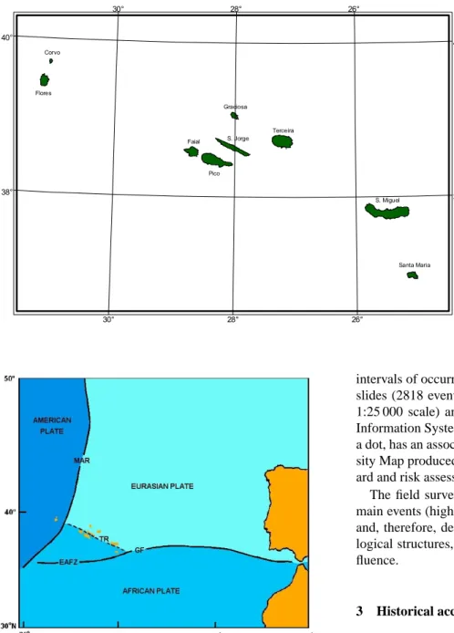
The Azores archipelago is located in the North Atlantic Ocean between 37◦–40◦N latitude and 25◦–31◦W longi-tude. It comprises nine volcanic islands and is situated where the American, Eurasian and African lithospheric plates meet (Fig. 1). The main tectonic structures that can be defined in this area are: (1) the Mid-Atlantic Ridge, which crosses the archipelago between the islands of Flores and Faial; (2) the Correspondence to: P. Valad˜ao (pv@notes.uac.pt)
East Azores Fracture Zone, that extends E-W from the Mid-Atlantic Ridge to Gibraltar; and (3) the Terceira Rift, which trends NW-SE from the Mid-Atlantic Ridge to N of Santa Maria Island. Several authors have studied the Azores Triple Junction and different geodynamic models have been pro-posed (Madeira and Ribeiro, 1990). The structural behaviour of the Terceira Rift, including the WNW-ESE Faial-Pico and S. Jorge fractures, is still a controversial issue (Fig. 2).
Due to its geographical location and geological setting, the Azores were affected by several natural catastrophes since its settlement in the 15th century. Destructive earthquakes, volcanic eruptions and landslides that occurred in historical times were responsible for many deaths and substantial dam-age.
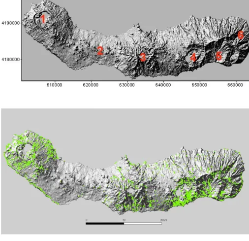
S. Miguel is located at the eastern end of the Terceira Rift and is marked by NW- SE, NE-SW and WNW-ESE tectonic features. E-W fault trends also occur and have been inter-preted as reflecting deep oceanic structures (Queiroz, 1997). The distribution of volcanic vents on the island is strongly related to tectonics, with active trachytic stratovolcanoes lo-cated at the intersection of the main faults’ systems, whereas cinder cones form impressive basaltic chains among the for-mer major volcanic structures (Fig. 3).
S. Miguel, the most populated island of the archipelago, has a very high risk for earthquakes, volcanic eruptions and landslides. This paper is part of a project about the geolog-ical hazard mapping of S. Miguel Island and explores the landslide problem, especially trigger mechanisms and the ge-ological environment.
2 Methodology
In order to produce this report, historical documents, newspa-pers, essay articles and scientific papers related to landslides observed on S. Miguel were collected, analysed and stored in digital form for later consultation. At the same time, and based on some published models proposed for other regions (e.g. Fossati et al., 2000; Antonini et al., 2000; Chowdhury
52 P. Valad˜ao et al.: Landslides density map of S. Miguel Island, Azores archipelago Terceira S. Miguel Santa Maria S. Jorge Graciosa Faial Flores Corvo Pico 38° 38° 40° 40° 30° 30° 28° 28° 26° 26°
Fig. 1. Geographical location of Azores
archipelago.
Fig. 2. Main tectonic structures that can be defined in the area of the
Azores Triple Junction. MAR (Mid-Atlantic Ridge); EAFZ (East Azores Fracture Zone); TR (Terceira Rift) (adapted from: Gaspar et al., 1999).
and Flentje, 1998; Cruden and Brown, 1992), a database was developed in order to include all the information needed to characterize such type of phenomenon.
The landslide mapping of S. Miguel Island was made through the observation of aerial photographs and field sur-veys. The identification of landslide by aerial photographs was based on morphological criteria, such as the presence of scars and in some places, the existence of an associated deposit. Aerial photographs taken in 1974, 1977, 1995 and 1998 (1:8000 and 1:15 000 scales) were analysed according to the above criteria, giving the possibility of establishing
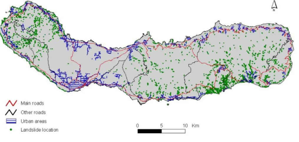
intervals of occurrence of certain events. All identified land-slides (2818 events) were plotted on a topographic map (at 1:25 000 scale) and then were entered into a Geographical Information System (GIS), where each event, represented by a dot, has an associated information sheet. A Landslide Den-sity Map produced using this tool (Fig. 4) helps explain haz-ard and risk assessment.
The field surveys had the objective of characterizing the main events (higher magnitude and/or the most recent ones) and, therefore, define its respective setting in terms of geo-logical structures, kinds of volcanic deposits and human in-fluence.
3 Historical accounts
Among the most important historic landslides that occurred on S. Miguel, the ones in 1522, 1630 and 1997 should be mentioned, not only due to their magnitude, but also to the loss of lives and/or destruction.
A very strong earthquake hit Vila Franca do Campo, the capital of the island at the time, on 22 October 1522. The epicentre was S of Vila Franca do Campo and the event had magnitude X on the Mercalli Modified Scale (Machado, 1966). This earthquake triggered a landslide on a hill satu-rated by water, which buried most of the village and killed near 5 000 people (almost everyone who lived there at the time).
Approximately one century later (3 September 1630) a volcanic eruption took place in the Furnas volcano. The eruption fluctuated between magmatic (subplinian) and phreatomagmatic episodes. Explosive activity was followed by the growth of a lava dome (Cole et al., 1995). Precursory earthquakes were felt a few hours before the beginning of
P. Valad˜ao et al.: Landslides density map of S. Miguel Island, Azores archipelago 53
Fig. 3. Main morphological provinces
on S. Miguel Island: (1) Sete Cidades Volcano, (2) Volcanic System of Picos Region, (3) Fogo Volcano, (4) Furnas Volcano, (5) Povoac¸˜ao Volcano and (6) Nordeste Volcanic Complex.
Fig. 4. Landslide Density Map for S. Miguel Island, Azores archipelago. Each green dot represents one landslide. A total of 2818 events are shown.
Fig. 5. Landslide density map for the landslides occurred in 31st
October 1997, at Povoac¸˜ao county. The green star represents the location of Ribeira Quente village.
the eruption (Corrˆea, 1924; Jer´onimo, 1989). Some of them caused “the hills to move” and “the land ran to the sea, en-tering the sea for 200 meters” (Jer´onimo, 1989). Cole et al.
(1995) interpreted these descriptions as being related to the landslide event that produced the debris flow deposit that un-derlies the 1630 AD tephra on the beach at Ribeira Quente. At that time, Ribeira Quente was apparently not permanently inhabited as it is today.
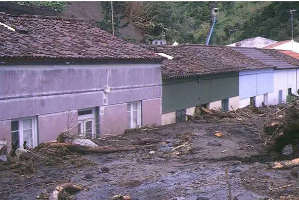
On 31 October 1997, nearly 1000 landslides occurred on S. Miguel Island, a few of them killing 29 people who were living in the Ribeira Quente village (Fig. 5). Povoac¸˜ao and Nordeste counties were particularly affected during this event (Gaspar et al., 1997; Gaspar and Guest, 1998). Sev-eral houses and bridges were partially or totally destroyed, communications, transportation and the energy supply sys-tem were disrupted and areas of fertile land became covered by mud (Fig. 6). Ribeira Quente village was isolated for more than 12 h (Fig. 7).
The main cause of this large-scale phenomenon was a lo-cal and catastrophic rainstorm. The strong SE winds that accompanied the heavy rain and the vulnerability of the vol-canic soils, already saturated as a result of long periods of continuous precipitation, certainly contributed to the magni-tude of the event (Gaspar and Guest, 1998).
Most of the landslides were essentially very fluid debris flows, consisting of a mixture of water, pumice and ash. Trees with their root systems, tree trunks and branches were included in most deposits. Depending on the source, some debris flows included large blocks of lava.
54 P. Valad˜ao et al.: Landslides density map of S. Miguel Island, Azores archipelago
Fig. 6. Houses affected by debris flows during the 1997 Ribeira Quente event.
P. Valad˜ao et al.: Landslides density map of S. Miguel Island, Azores archipelago 55
Fig. 8. Landslide Risk Map for S. Miguel Island, Azores archipelago.
Although there were some exceptions, the majority of the landslides originated on very steep slopes, with small thick-ness but considerable length.
4 Discussion
The reported historical accounts emphasize the high poten-tial landslide hazard on S. Miguel Island, triggered by catas-trophic rainfall episodes, earthquakes and volcanic eruptions. It is clear, from the analysis of the Landslide Density Map that most landslides are related to the young central volca-noes and sea cliffs in their vicinity. Vertical caldera walls, rel-atively steep slopes, deep streamlines and several fault scarps characterize these central volcanoes, which are covered by unconsolidated pyroclastic deposits from recent explosive eruptions. The old basaltic volcanic complex of Nordeste, marked by deep gullies developed on thick sequences of lava flows, some of them very altered, also has a high number of landslides.
On the other hand, the volcanic system of the Picos Re-gion shows the lowest concentration of landslide events. This is due to the fact that this area is mainly built up by recent basaltic lava flows, with minor interbedded scoria deposits, presenting gentle slopes and just a few immature valleys.
5 Conclusions
The historical bibliographic analysis done in this work shows that S. Miguel is very vulnerable to natural catastrophes as a result of its geographical location and geological set-ting. Earthquakes, volcanic eruptions and landslides have marked the island’s history over the last 500 years, result-ing in thousands of deaths and significant damage. Land-slides were triggered by rainfall episodes, earthquakes and volcanic eruptions and occurred with special incidence at the main central volcanoes and at the old basaltic volcanic com-plex.
The superimposition of the main cities, villages and basic infrastructures of S. Miguel on the Landslides Density Map
emphasizes the high risk that exists in certain areas of the is-land (Fig. 8). Emergency and is-land use planning are needed in order to minimize the impact of future complex/multiple events. Authorities should be aware of the importance of haz-ard and vulnerability assessment to ensure the normal socio economic development of the region.
Following this work, other studies are in progress in order to produce landslide hazard/risk maps for S. Miguel Island. This includes numerical and statistical analysis (e.g. Carrara et al., 1978; Carrara, 1983; Leroi, 1996), isopleths mapping (e.g. Bulut et al., 2000; De Graff and Canuti, 1988; Wright et al., 1974) and geotechnical models (e.g. Chowdhury, 1984; Hammond et al., 1992, Wu and Abdel Latif, 1994; Nguyen and Chowdhury, 1995), considering variables such as geol-ogy, litholgeol-ogy, slope and soil resistant properties.
Acknowledgements. This work was supported by the Azores
Re-gional Government through the Secretaria ReRe-gional da Habitac¸˜ao e Equipamentos and is part of the project Carta de Riscos Geol´ogicos da Regi˜ao Aut´onoma dos Ac¸ores.
References
Aleotti, P. and Chowdhury, R.: Landslide hazard assessment: sum-mary review and new perspectives, Bull. Eng. Geol. Env., 58, 21–44, 1999.
Antonini, G., Ardizzone, F., Cacciano, M., Cardinali, M., Castel-lani, M., Galli, M., Guzzetti, F., Reichenbach, P., and Salvati, P.: A geomorphological approach to estimate landslide hazard and risk in urban and sub-urban areas: examples from the Umbria re-gion, European Geophysical Society, XXVI General Assembly, Nice, 2000.
Bulut, F., Boynukalin, S., Tarhan, F., and Ataoglu, E.: Reliability of landslide isopleth maps, Bull. Eng. Geol. Env., 58, 95–98, 2000. Carrara, A., Catalano, E., Sorriso-Valvo, M., Reali, C., and Ossi, I.: Digital terrain analysis for land evaluation, Geologia Applicata e Idrogeologia, 13, 69–127, 1978.
Carrara, A.: Multivariate methods for landslide hazard evaluation, Mathematical Geol., 15, 403–426, 1983.
Chowdhury, R. N.: Recent developments in landslide studies: prob-abilistic methods - state-of-the-art-report, in: Proc. IV Int. Symp. Landslides, Toronto, 1, 209–228, 1984.
56 P. Valad˜ao et al.: Landslides density map of S. Miguel Island, Azores archipelago
Chowdhury, R. N. and Flentje, P.: A landslide database for landslide hazard assessment, in: Workshop on landslide hazard assessment – Progressing from qualitative to quantitative approaches, Wol-longong, 1998.
Cole, P. D., Queiroz, G., Wallenstein, N., Gaspar, J. L., Duncan, A. M., and Guest, J.: An historic subplinian/phreatomagmatic eruption: the 1630 AD eruption of Furnas volcano, S. Miguel, Azores, J. Volcanol. Geotherm. Res., 69, 117–135, 1995. Corrˆea, J.: Leituras sobre a hist´oria do Vale das Furnas, Oficina de
Artes Gr´aficas, S. Miguel, Ac¸ores, 217, 1924.
Cruden, D. M. and Brown, W. M.: Progress towards the World Landslide Inventory, in: Proc. VI Int. Symp. Landslides, Christchurch, 1, 59–64, 1992.
DeGraff, J. and Canuti, P.: Using isopleth mapping to evaluate land-slide activity in relation to agricultural practices, Bull. Int. Ass. Eng. Geol., 38, 61–71, 1988.
Fossati, D., Mazzoccola, D., Sciesa, E., and Ceriani, M.: Precedure per la valutazione e la zonazione della pericolosit´a e del rischio da frana in regione lombardia, Bollettino Ufficiale Regione Lom-bardia, Milano, 51, 63, 2000.
Fructuoso, G.: Livro Quarto das Saudades da Terra, Ed. Instituto Cultural de Ponta Delgada, 1977, 1–2. 1583.
Gaspar, J. L., Wallenstein, N., Coutinho, R., Ferreira, T., Queiroz, G., Pacheco, J., Guest, J., Tryggvason, E., and Malheiro, A.: Considerac¸˜oes sobre a ocorrˆencia dos movimentos de massa reg-istados na madrugada de 31 de Outubro de 1997 na ilha de S. Miguel, Aores, Relat´orio T´ecnico-Cientifico 17/DGUA/97, cen-tro de Vulcanologia, 28, 1997.
Gaspar, J. L. and Guest, J.: The 31st October 1997 landslides at S. Miguel Island, Azores: a dramatic lesson for the future, Volcanic Hazard Assessment, Monitoring and Risk Mitigation; Advanced
Study Course, European Commission, 43, 1998.
Gaspar, J. L., Trota, A., Queiroz, G., Ferreira, and T. e Alves, P.: Plano Municipal de Emergˆencia da Vila do Porto, Cˆamara Mu-nicipal de Vila do Porto, Ilha de Santa Maria. Centro de Vul-canologia da Universidade dos Ac¸ores, 1999.
Hammond, C., Prellwitz, R., and Miller, S.: Landslide hazard as-sessment using Monte Carlo simulation, in: Proc. VI Int. Symp. Landslides, Christchurch, 2, 959–964, 1992.
Jer´onimo, G. M.: N´os, ac¸orianos e os sismos, Correio dos Ac¸ores, 1989.
Leroi, E.: Landslide hazard – Risk maps at diferent scales: objec-tives, tools and developments, in: Proc. VII Int. Symp. Land-slides, Trondheim, 1, 35–52, 1996.
Machado, F.: Anomalias das intensidades do terramoto de S. Miguel (Aores) em 1522, Bol. Mus. Lab. Min. Geol. Fac. Ciˆen. Lisboa, 10, 2, 109–117, 1966.
Madeira, J. and Ribeiro, A.: Geodynamic models for the Azores Triple Junction: a contribution from tectonics, Tectonophysics, 184, 405–415, 1990.
Nguyen, V. and Chowdhury, R.: Risk analysis with correlated vari-ables, Geotechnique, 35, 47–59, 1995.
Queiroz, G.: Vulc˜ao das Sete Cidades (S. Miguel, Ac¸ores), Hist´oria eruptiva e avaliac¸˜ao do hazard, Tese de Doutoramento, Universi-dade dos Ac¸ores, 226, 1997.
Wright, R. H., Campbell, R. H., and Nilsen, T. H.: Preparation and use of isopleth maps of landslides deposits, Geology, 2, 483–485, 1974.
Wu, T. H. and Abdel-Latif, M. A.: Prediction, mapping and updat-ing of landslide hazard, Proc. Conf. On Deep Foundation Ground Improvement, AIT Bangkok, 1994.