© EDP Sciences, Springer-Verlag 2012
DOI:10.1140/epjst/e2012-01701-5
P
HYSICAL
J
OURNAL
S
PECIALT
OPICS Regular ArticleComplexity aided design
The FuturICT technological innovation paradigm
A. Carbone1,2,a, M. Ajmone-Marsan1,3, K.W. Axhausen2, M. Batty4, M. Masera5,
and E. Rome6
1 Politecnico di Torino, Italy 2 ETH Zurich, Switzerland 3 IMDEA Network, Madrid, Spain 4 UCL, UK
5 JRC, Petten, The Netherlands 6 Fraunhofer IAIS, Germany
Received in final form 9 October 2012 Published online 5 December 2012
Abstract. “In the next century, planet earth will don an electronic skin. It will use the Internet as a scaffold to support and transmit its sensations. This skin is already being stitched together. It consists of millions of embedded electronic measuring devices: thermostats, pres-sure gauges, pollution detectors, cameras, microphones, glucose sensors, EKGs, electroencephalographs. These will probe and monitor cities and endangered species, the atmosphere, our ships, highways and fleets of trucks, our conversations, our bodies–even our dreams ....What will the earth’s new skin permit us to feel? How will we use its surges of sensation? For several years–maybe for a decade–there will be no cen-tral nervous system to manage this vast signaling network. Certainly there will be no central intelligence...some qualities of self-awareness will emerge once the Net is sensually enhanced. Sensuality is only one force pushing the Net toward intelligence”.
These statements are quoted by an interview by Cherry Murray, Dean of the Harvard School of Engineering and Applied Sciences and Professor of Physics. It is interesting to outline the timeliness and highly predicting power of these statements. In particular, we would like to point to the relevance of the question “What will the earth’s new skin permit us to feel?” to the work we are going to discuss in this paper. There are many additional compelling questions, as for example: “How can the electronic earth’s skin be made more resilient?”; “How can the earth’s electronic skin be improved to better satisfy the need of our society?”;“What can the science of complex systems contribute to this endeavour?”
1 Introduction
Millions of networked devices, sensing, filtering, interpreting and transferring data, are being embedded in the physical world at a tireless pace [1]. Massive amount of information bytes about online game players, customers, suppliers, and operators are captured at a constantly increasing rate with this exponential growth continu-ously fueled via smart phones and social networks. This large pool of data–captured, communicated, aggregated, stored and analyzed on the fly– become more and more essential to every sector and function of the global economy [2–4]. In this scenario, highly innovative concepts and approaches need to be deployed for the effective gov-ernance and full exploitation of the information, its collection and distribution, in the interest of an increased knowledge, the ordered management and development of our planet, as envisioned within the FuturICT endeavour [6]. Like other essential fac-tors of production such as hard assets and human capital, much of modern economic activity, innovation, and growth simply couldn’t take place without data and net-worked infrastructures. What do these phenomena imply? Is the proliferation of this networked structure simply evidence of an increasingly intrusive and uncontrollable world? How can Big Data play a useful role for society’s well-being? To build upon and capture value from these processes and Big Data, academic institutions, public and private research centers are urged to develop and deploy:
– Efficient Technologies for sensing, storing, computing;
– Complex Systems Methodologies for analysing and extracting meaning from data; – Suitable Policies and Protocols for the governance of data and processes.
The range of technology challenges will broadly differ, depending on the maturity of the application areas. Legacy systems and incompatible standards too often prevent the integration of systems and data on which the more sophisticated analytics should be built to create value from big data. New problems and growing computing power will spur the development of new analytical techniques.
Our society is unable to understand and cope with the complexity of today’s techno-socio-economic systems. There is a need for ongoing innovation in technolo-gies and techniques to support individuals and organizations to integrate, analyze, visualize and consume the growing torrent of information generated by our connected world. The present effort deals with those technologies that are making possible and functioning the network of networks, which are nowadays a main asset of our economy. It is obvious that writing a paper covering all the technological challenges related to the networked systems where we live would be highly ambitious and probably impos-sible to accomplish. We limit ourselves to a few remarkable examples trying to reason on why these represent challenges for our economy and society. We call our endeavour “Technology Exploratory”, which is an element of the more complex structure of Exploratories including the “Society Exploratory” [7], “Economy Exploratory” [8] and “Environment Exploratory” [9] envisaged as a networked Research Infrastruc-ture, within the overall FuturICT structure (as sketched in Fig. 3 of [6]). This in-tegrated set of “Exploratories” would ultimately become an instrument for enabling an improved understanding, creating a basis for policy making based on a cross-disciplinary approach to the system of networks. The set of Exploratories will also operate for capacity building by:
– supporting experts in the key FuturICT disciplines;
– attracting and training young researchers in a multi-disciplinary environment; – boosting the number of experiments in system-of-systems investigations/
The Exploratory concept revolves around the FuturICT vision [6] that it is essential to exploit the power of information and communications technologies, to engage re-searchers, policy-makers and a range of public interest groups to inform, alleviate and solve critical problems, often referred to as ‘grand challenges’, dealing with energy, aging, migration, climate change, competition, and social equity. Due to the strong connections across techno-socio-systems, all these problems require powerful models and tools in their resolution. In particular, new approaches to complexity –focused on ways in which scientists and policy makers can come together to provide informed so-lutions to these questions– are central to the models that will be pioneered, extended and applied in the Exploratories. New approaches to computation and new ways of organising ICT can spearhead new ideas to the governance and design of future soci-eties, and provide new capabilities to the interaction among all actors and technical systems and devices. In this framework, smart technologies can be used to underpin city planning, transportation management, energy provision and usage, security and privacy all in the wider context of the grand challenges that currently pervade our society.
1.1 Scientific and societal challenges
The Technology Exploratory will respond in concert with the other FuturICT com-ponents to the key grand challenges with respect to sensing, measuring, and mining physical and social data, within the wider FuturICT platform context to ensure that our understanding of these challenges and advances is coordinated and integrated [10–12]. This is a prerequisite that reflects the way ICT can be used to inform and solve socio-economic problems, formulate and explore future policies, to implement the output of the investigation to our social condition. A few major directions can be identified within this perspective:
– Integrating and coordinating “Systems of Systems” information concerning every-day citizen life. Information and Communication Technologies are being developed to increase the efficiency of energy systems, to improve the delivery of services ranging from utilities to retailing in cities, to improve communication and trans-portation, and to guarantee the security of these new technologies. Integration and coordination of diverse systems across functional and organizational boundaries, and even across jurisdictional and national borders, is crucial to ensure that value is added and that the efficiencies realised are not dissipated.
– Understanding “Systems of Systems” behaviour by integrated thinking as envis-aged by Complexity Sciences. During the last 20 years, many new approaches to modeling and simulating techno-socio systems have been devised that involve holistic thinking. These approaches require further development in order to make the policies concerning smart cities, transport and energy much more resilient than hitherto. The great challenge is to foster convergence of interests and concerns of private and public actors involved. As “Systems of Systems” have no single master, the optimal solution satisfying all actors would rarely exist.
– Ensuring equity, fairness and achieving a better quality of life through new tech-nologies. Efficient economic development must be balanced with equity, while new technologies have a tendency to polarise and divide at many levels. Efficient ways in which new forms of regulation can be developed and implemented leading to better quality of life for all should be paved. Other solutions might foresee the empowerment of citizens, both as individual and as members of social networks, in their interconnections with techno-socio systems and infrastructures.
– Ensuring widespread participation through new technologies. New social ICT is es-sentially network based and enables everyone to interact with those systems across
many domains and scales. Part of the process of coordination and integration, by using state of the art data systems and distributed computing, must involve ways in which the citizenry is able to participate and blend personal knowledge with that of experts who are developing these technologies. The rate of appearance and set of capabilities of those technologies might overwhelm the end user, affecting social acceptance and social engagement. Privacy concerns as well as security are key to this challenge.
As reported in [13], “as power shifts from the physical to the virtual world, a new paradigm for ensuring a health digital space should emerge...Online security is a public good and new mechanisms are urgently required to secure private invest-ment in exploring existing system vulnerabilities before they can be exploited”. In the same report, five main category of risks are outlined: Economic, Environmental, Geopolitical, Societal and Technological. It is worth noting that critical system fail-ure and cyber attack are ranked first respectively according to the impact – or the likelihood- these events might have on society. An overview of the interconnection between technological and social risks is reported in [14]. In this virtual structure of our society, a paradigm shift is required in defining new leadership models and organizational scheme. Leadership and organizational models of the last century are mostly based on top-down, bureaucratic paradigms suitably working for an economic system based on “physical production” [15]. The leadership should emerge as a re-sult of adaptive outcomes -learning, innovation and adaptability- analogously to the complex dynamics of interactions in the new virtual mode of economic and social organization. It is important to notice that the advantages of an organizational struc-ture based on an adaptive mechanism of self-organization was already argued in [16]. Today these concepts have become urgent at larger scales and level due to the in-creasing complexity of multilevel and multiscale interactions pervading every sector of our current societal organization.
1.2 Innovation challenges
Innovation plays a vital role in the development of new business concepts, processes and products, driving growth and opportunity in new markets and breathing new life into a mature industry. As businesses are gradually and globally expanding, innova-tion will become a leading industry differentiator. In the tough battle to match and conquer the customers dreams and desires, innovation is a prerequisite for success and survival. Public and private research centers can rapidly lose reputation and market shares if they fail to translate their innovation into practise. Failure to innovate and the risk of technology/system failure entered the Top 10 Rank List for the first time in 2011 [14] since the start of Global Risk Survey in 2007.
The innovation challenges that we are going to face over the 21st century are
ex-pected to emerge from the main technological innovations of the 20thcentury listed in Table 1 [17] as the latter have followed up the industrial and infrastructural transfor-mation of the 19th century. The 20th century items are ranked in Table 1 according
to the benefits brought to people. One should note that most of those technologi-cal achievements have been accomplished thanks to outstanding findings and break-through in fundamental sciences. Their development and exploitation depended for the most part on the economic wealth they generated that ultimately contributed to make them even more universally available.
Competitive strategies should not be based only on the current market conditions but also on where the industry is heading. The “tried and true” business model, which proved successful in the past, can no longer be the only model to meet society needs and ensure competitiveness. More than ever, innovation, speed and adaptability are
Table 1. A list of the 20th Century Innovations Challenges according to their importance for social well-being [17].
1 Electrification 2 Automobile 3 Airplane
4 Water supply and distribution 5 Electronics
6 Radio and Television 7 Agricultural mechanization 8 Computers 9 Telephone 10 Air conditioning/refrigeration 11 Interstate Highways 12 Space flight 13 Internet 14 Imaging 15 Household appliances 16 Health technologies 17 Petrochemical technology 18 Laser and fiber optics 19 Nuclear technologies 20 High-performance materials
essential for competing in the global economy. According to the “World Intellectual Property Organization”, the number of applications for global patents rose 10 percent in 2010, when the economic crisis had induced a significant drop in other activities. This number is expected to grow steadily in the next two years. The 2011 survey high-lights that the ability to embrace and leverage technology is emerging as a dominant factor underlying many of the key risks facing organizations. With the heavy reliance on their technological infrastructure (especially ICT), businesses are becoming more vulnerable to system failures, data breaches and social media exposure, causing busi-ness interruptions, loss of customers and damage to reputation. The importance to develop appropriate measures to mitigate those risks will steadily increase as private and public infrastructures rely more heavily on new ICT technologies. Critical factors to ensure good performance of any innovative business are:
– Continuity, whose disruption will lead to losses and may even result in bankruptcy. – Security of data, which is vital to protect intellectual property against espionage
and other data against theft or abuse.
– Technological innovation and competition, new technologies need to be identified that could offer new opportunities for businesses. The effects that these technolo-gies will have on politics and society and their indirect consequences need to be identified and managed.
– Failure to attract or retain top talents, Academies, private and public research centers and companies should innovate to create the most appropriate environment for attracting and retaining top talents and foster further innovation.
Key factors allowing the above conditions for innovation and development are ro-bustness of internal and external critical infrastructures (IT networks and telecom-munication systems, energy and water supply, financial network system, supply chain and transport) against natural disasters, cybercrimes and other relevant hazards and threats.
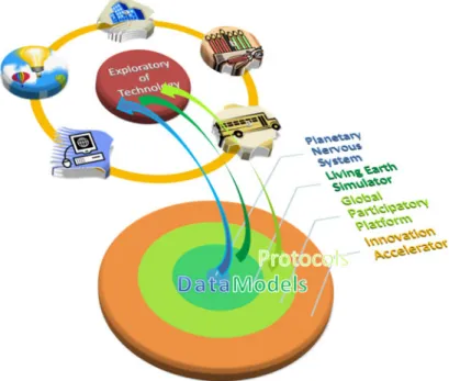
Fig. 1. Scheme of the main components of the Technology Exploratory. The grid representa-tion allows to distinguish the horizontal cross-sectorial technologies and the vertical sectorial technologies. The underlying frame corresponds to the issue of critical infrastructures which belong both to horizontal and vertical technological sectors. All the components have close relationships to the other Exploratories (Society, Economy, Environment) and to the main components of the FuturICT Platform (Global Participatory Platform, Planetary Nervous System, Living Earth Simulator).
Table 2. Top 10 Risks: AON Global Risk Survey 2011.
2011 2010 2009
1 Economic Slowdown Economic slowdown Damage to reputation 2 Regulatory legislative
changes
Regulatory/legislative changes
Business interruption 3 Increasing Competition Business interruption Third-party liability 4 Damage to reputation
brand
Increasing competition Distribution or supply chain failure
5 Business Interruption Commodity price risk Market environment 6 Failure to innovate or
meet customer needs
Damage to reputation Regulatory/legislative changes
7 Failure to attract or re-tain top talent
Cash flow/liquidity risk Failure to attract or re-tain staff
8 Commodity price risk Distribution or supply chain failure
Market risk (financial) 9 Technology or system
failure
Third-party liability Physical damage 10 Cash flow liquidity risk Failure to attract or
re-tain top talent
Failure of disaster recov-ery plan
2 Scientific vision and state of the art
The FuturICT vision could not be conceived without our daily experience of the Internet and wireless data networks, without our confidence in acquiring and trans-ferring information about any human or artificial system and the awareness that the doors are now opened to creative ideas for the exploitation of several new features. Telecommunication networks, and in particular wireless access systems, from mobile phone to WiFi, to newer technologies, such as sensor networks, on one side, and the Internet on the other, have already transformed our world, leading to the society of connected individuals of the “Internet of People”.
It will soon take us to the next step: a world where also objects and machines are interconnected among them, and with people, that is the basic concept underlying the upcoming “Internet of Things” which refers to sensors and actuators embedded in physical objects, connected by networks to computers [1].
The central role of networking in the FuturICT vision reflects the way we live and work. Today, social relations, economic processes and markets, transport sys-tems, health care syssys-tems, etc., largely depend on networking for increased efficiency, reliability, security, and safety. Models of transportation, urban planning and energy system operations are under continuous development and refinement. One reason is that the way these systems operate are strongly dependent on the development and availability of new ICT technologies through the different sectors of human activities. Another reason relates to the continuous modification of social regional, national and transnational organization. The overall result is that as more and more aspects of human activities become interconnected by the availability of new technologies, the degree of complexity of this evolving system increases. Hence a set of scenarios need to be envisaged through a cross-disciplinary integrated long-term evolutionary vision. Our society can benefit from integrating data, software and related protocols for the purposes of building better cities, transport and energy supply systems. However one has to consider that these systems are composed of autonomous sub-systems, each one owned and operated by self-governing entities.
Concepts and tools traditionally belonging to the complex system science are in-creasingly adopted to tackle the complexity of such techno-socio systems. Probabilistic models describe speed drop by modeling vehicular flow as an open non-equilibrium system of driven or active particles with energy generation/dissipation and possibly phase transition phenomena in the global traffic behavior. Complex network tools have become increasingly exploited for describing critical behavior of electrical power grids. Analogously to the multi-agent models for financial investors, drivers are mod-eled for example as heterogeneous agents with the level of heterogeneity (e.g. in car-following behavior) quantified by trajectory observations recorded by means of GPS and cellular phone. Herding behavior concepts are applied to car drivers, energy and good consumers to investigate the effects of leader followers on the same lane, on the same power grid or commodity chain supply [18–20].
However, much remains to be done, for the improvement of today systems and their integration in a “Planetary Nervous System” that is capable of managing and integrating more and more diverse amount of information than what we handle to-day, so as to be able to understand and control the dynamics governing the internal behavior of each domain, and those that from one domain influence the others. Much remains to be done for the definition of new generations of networking able to scale to the dimensions required to allow a seamless transition to the FuturICT vision, with the necessary resilience and dependability. It must not be forgotten that large network systems are critical infrastructures in themselves, and thus need to be monitored, pro-tected, controlled, and secured. These aspects are a fundamental but preliminary step required to address further more specific technological challenges of FuturICT. With-out scalable, robust, safe, secure, efficient networking support, the FuturICT concepts might not be thought of.
The research challenges to achieve these goals are huge. The amount of data to be collected, transferred, processed and analyzed for the implementation of the FuturICT vision is humongous. The complexity inherent in the control approaches is still to be discovered. Networks include different layers: they are not only technolog-ical, but also social and economical. Anticipating the networks of the future requires experimenting with technologies and observe their adoption by society with diverse adaptation processes. This multi-disciplinarity further complicates the research. How-ever, the benefits that can result from the insights are enormous, and can drastically
improve the life of future generations through components of the FuturICT project as for example the Planetary Nervous System [11], the Living Earth Simulator [10], the Global Participatory Platform [12], smart applications for cities [43], energy [40], education [24] and innovation services [22].
BOX 1: Relevant initiatives and projects 1. Open Data http://make.opendata.ch/index.en.php
2. Cisco Smart Connected Communities http://www.cisco.com/web/strategy/ smart connected communities.html
3. Oracle Smart Cities www.oracle.com/us/industries/public-sector/ smart-cities.htm
4. Ericsson http://www.ericsson.com/res//thecompany/docs/publications/ business-review/2011/issue1/delivering-smarter.pdf
5. IBM Smarter Planet http://www-05.ibm.com/innovation/uk/smartercity/ 6. Multiagent Transport Simulation www.matsim.org
7. Google maps http://maps.google.com
8. Nokia maps http://europe.nokia.com/support/product-support/ maps-support/compatibility-and-download
9. OECD (2008): Protection of Critical Infrastructure and the role of investment poli-cies relating to national security, May 2008.
10. OpenMI Association, http://www.openmi.org/
11. Open Geospatial Consortium (2008a). Open GIS Keyhole Markup Language (KML) Version 2.2.0.
12. Open Geospatial Consortium (2008b). OpenGIS City Geography Markup Language (CityGML) Encoding Standard, Version 1.0.0.
13. TNOs Critical Infrastructure Disruption Database, Version 217, 14 June. TNO (2009).
2.1 Networking: From beneath earth to the clouds
Wired and wireless data networks play a key role in many areas of FuturICT and thus are one of the pillar research activities in the framework of the fundamental Technologies. Data Networks are:
– main building blocks for the achievement of main FuturICT goals, from smart grids to intelligent transport and logistics, by collecting vast amount of data and acquire the necessary information about the many variables of the systems to be monitored and controlled.
– main enabling technology for the protection of critical infrastructures, social par-ticipation systems, smart sensing environments, e-health services, and environ-ment monitoring and protection, impleenviron-menting data processing through cloud computing approaches, identifying appropriate mechanisms for the effective con-trol of the systems being monitored.
– relevant example themselves of critical infrastructure and of an essential service to our society.
In summary, network technologies are a key enabler for the distributed simulation of the living planet over large numbers of computers, possibly adopting the cloud concept and for the implementation of many of the FuturICT visions, from smart cities
to smart grids, from intelligent transport and logistics to the protection of critical infrastructures, from social participation systems to smart sensing environments, from e-health services to environment monitoring and protection. While data networks have experienced an impressive development over the last 20 years, the present level of technology is not sufficient to be painlessly adopted ‘as is’ for the achievement of the FuturICT goals. Indeed, on the one hand, the number of data collection points and the amount of information to be carried and filtered requires significant advances in architectural and technological aspects, and, on the other hand, some peculiar characteristic of the FuturICT systems pose challenges that have never been explored before as for examples:
– IP addressing. This is a major problem of the present networks mostly based on IP version 4. The transition to version 6 has been encouraged many times with very little success. The myriads of network terminals foreseen by FuturICT require new addressing approaches. It might be that even such version 6 turns out not to be adequate, so that new alternatives must be explored.
– Resilience and fault. Todays networks include resilience and fault tolerance ap-proaches, but they are based on the assumption that most network elements are interconnected most of the time. The only exception that has received significant attention in the technical literature is given by the so-called Delay Tolerant Net-works (DTN), where only subsets of the network elements are interconnected for significant portions of time. The FuturICT context (at least for some applica-tions, like, for example, environmental monitoring) may be such that most of the network elements are disconnected most of the time. The possibility of effective networking in such case has yet to be proven, and adequate architectures have to be studied.
– Security and privacy are key issues for FuturICT, at different levels: the data to be collected and transported are confidential, the injection of wrong data in the system may lead to incorrect conclusions, the access to data and to conclusions may be restricted to authorized individuals or terminals. The scale of the FuturICT networks and the amount of information involved require to redesign the current security and privacy approaches implying a paradigm shift in this area.
– Continuous real-time monitoring of extremely large numbers of variables. The use of such variable is required as input for the “Living Earth Simulator”. The corre-lation intrinsic in the series of observations for one variable is normally very high, so that intelligent information filtering and data clustering before transmission should be reasonably performed. However the setting of the parameters for this operation is quite delicate, and requires serious and appropriate investigation. – Distribution of information storages. The efficient access to information within
networks is an issue which has been tackled by Content Distribution Networks (CDN) and Peer-to-Peer (P2P) systems. Content Centric Networking (CCN) also addresses the same issues. The huge amount of information required for the im-plementation of the FuturICT vision calls for new specific approaches.
– Redundancy and network dependability. Role of data networks in FuturICT is vital and thus network resilience and dependability are crucial for the success of the project. However, the size of the network and the amount of data to be stored are extreme, so that providing redundancy implies very high cost. A very careful investigation of the most effective approaches to achieve the desired level of network dependability is a must.
The cloud is an emerging ICT technology that would act as a further key compo-nent to catalyze the FuturICT platform [25–27]. The basic idea of cloud computing is that many software functions are moved and operated by the cloud rather than on individual computer facilities and servers. It is one of the highest expression of
“vertical integration” that will trigger new inventions ranging from the basic tech-nologies to the communication and multimedia sectors. A summary of the main fea-tures of cloud computing can be found in [? ]: on-demand self-service, broad network access, resource pooling, rapid elasticity and measured service. Cloud computing ap-plications are usually optimized to provide a simpler, easy-to-use interface, reducing the learning effort and offering increased communication capacity between various software packages. Cloud computing is often considered an environmentally-friendly ICT technology as the information resources and software applications are centrally maintained and managed, thus reducing financial and energetic cost according to the use.
Nonetheless, the series of articles “The Cloud Factories” recently appeared on the New York Times on September 23rd 2012 evidenced that not everything is always
green in the cloud.
1. “Online companies typically run their facilities at maximum capacity around the clock, whatever the demand. As a result, data centers can waste 90 percent or more of the electricity they pull off the grid ”.
2. “Energy efficiency varies widely from company to company. But at the request of The Times, the consulting firm McKinsey & Company analyzed energy use by data centers and found that, on average, they were using only 6 percent to 12 percent of the electricity powering their servers to perform computations”. 3. “To guard against a power failure, they further rely on banks of generators that
emit diesel exhaust. The pollution from data centers has increasingly been cited by the authorities for violating clean air regulations”.
4. “Nationwide, data centers used about 76 billion kilowatt-hours in 2010, or roughly 2 percent of all electricity used in the country that year”.
Security and privacy are major concerns for many users that transfer their data from locally-maintained servers to cloud computing systems. Especially since the very nature of virtualization means data and applications stored in a way that allows them to be easily accessible online. For this reason, better security methods must be employed in order to keep valuable information protected from intrusion or theft. Improved practices therefore include higher degrees of password protection, additional levels of security at the hosting site, and other advanced computing security measures designed to protect the company’s sensitive financial and proprietary information.
2.2 The sensor web: World wide sensing and imaging
The dramatic progress in ICT and Internet-based applications has the main conse-quence that individuals and organizations are exposed to an ever-increasing stream of data [29]. In such a digital environment, the burden caused by information overload and processing is largely compensated for by the extraordinary potential which the availability of plentiful distributed data unleash for the management of our complex environment. Once data is collected, stored and processed, users need to be able to access, evaluate and explore their data by using friendly tools. Visualization provides a creative way to address the issues by offering means to manipulate and make sense of large amount of data and the embedded information. They also yield new capa-bilities to amplify cognition. This sector of the FuturICT Technology Exploratory will be responsible to increase knowledge, to innovate and explore the possibilities offered by visualization tools and more generally virtual reality technologies. Three main application areas will be highlighted with the relevant roles that information
visualization can play as a tool to:
1. monitor and supervise spatially distributed systems, such as land territories and urban regions. Focus is needed on the methods and tools to integrate and make sense of concurring spatio-temporal relevant phenomena, such as those concerned with urban security, environmental risks, energy and transport management, thus supporting decision making in complex environments.
2. navigate through large data-base, in this case, visualization helps to achieve an interpretation about data exhibiting meaningful complex patterns or correlations. This is the realm of visual analytics a scientific field which is being established at the crossroads between design and computing.
3. facilitate communication with the aim to bridge the technological challenges to the social need and knowledge for the co-generation of information communities. The role of information visualization in providing contexts for general public in-formation and thus adding social value to it are tasks particularly relevant to the Exploratory of Technology.
Visualization is indeed an essential tool to analyze data generated in diverse fields. Experiment and numerical simulations performed on systems belonging to social sci-ences, climate modeling, biological tissue are some examples of large amounts of data that exhibit complexity features (self similarity over a wide range of spatial and temporal scales). To quantify and understand features like formation of patterns, clustered structures and provide a realistic representation of such structure, efficient and accurate analytical tools are required.
The available data sets, e.g. those related to public health and environmental science, are however highly heterogeneous and the complex multivariate relationships among variables are often unknown. Integration of traditional cartographic methods with those from information visualisation can provide researchers and analysts with a range of tools for visually as well as statistically and computationally exploring these relationships.
A urgent need to go far beyond just the capability to make sense of huge data through visualization will relate to the development of a “Causality Discovery Visualization Technology” as argued in [30,31] to understand and quantify causal relationships and thus the underlying complex dynamics of visual structures. More-over, imagine if we could also virtually touch, hear and smell while navigating in a virtual environment. All our senses will cooperatively be conveyed to remotely under-stand our complex world -as we do usually in our normal life. Computer applications need to be designed for quantifying complex systems characterized by self-similar heterogeneity across space. In particular, three-dimensional or higher dimensional forms of random heterogeneous media are particularly interesting in this endeavour. The local microstructure can be quantified as a three-dimensional fractional Brown-ian field and the relevant parameters defined in terms of spatio-temporal correlation measures [32,33,35].
Development of sophisticated virtual reality tools is extremely timely for e-governance. Visualisation platforms integrate virtual reality, geo-web, and visual an-alytics to empower stakeholders and citizens in choosing and evaluating the impacts of policies for their cities or regions. The main aim of this platform is to clarify and communicate complex policies easily. Governments and Agencies can use the plat-form to develop and implement policies with public participation, actively engaging the public in the policy-making process [36–39].
Large scale real-time three-dimensional visual simulations rely on very high com-putation performance and rendering efficiency with further implied issues regarding interoperability, costs, flexibility, accessibility, usability, and information privacy. Key
Fig. 2. The Cloud Factories: Power, Pollution and the Internet. Data centers are filled with server, which are like bulked desktop computers, minus screen and keyboards, that contain chips to process data. (Photo Ethan Pines for The New York Times 23 September 2012.)
technological problems range from database file format, real-time rendering algo-rithms and texture atlases, model simplification and dynamic paging, multidimen-sional database management and parallel computing, remote visible and infrared sensing, photogrammetry and geo-information encoding, shape grammars, web 2.0 techniques and web-services. It is nowadays possible to integrate such enhanced mod-els into the information layers of the internet creating what is known as the “Sensor Web”. These advances have provided the opportunity to create innovative Informa-tion Systems to be widely exploited in urban land management, as intuitive interface to urban planning information and visualization of future scenarios. Virtual reality models are envisaged to overlap local data infrastructures for planning in areas as transportation, logistic, energy, climate, air quality, fire propagation, health and pub-lic safety studies. Image sensors directly measure the depth of objects, which provide an ideal data set for urban modelling. The quantity of data, image noise, lighting conditions, occlusions, and scene complexity complicate acquisition and elaboration. Automatic modelling requires automatic structure segmentation and reconstruction, which is complicated by occlusions between buildings or vegetation against buildings. Fusing ground and aerial image sensors, aerial active sensors, and 2D footprint data from GIS or CAD data can generate more accurate and automatic urban models (hybrid sensor systems). 3D building models can be integrated into spatial databases and geographic information systems (GIS) to support urban planning and analysis applications. Geo-data types (raster data and vector data) can be integrated into the 3D city model by draping them over the digital terrain model, which is a basic tool in 3D Geovisualisation. Further methods for the integration of vector data exist, such as visualising point features as 3D symbols or extruding polygons to 3D blocks. Vast digital data resources include geospatial referencing, ranging from precise geographic coordinates, to street addresses and codes (such as zip codes and drainage basin in-dices). GPS receivers, PDAs, and cell phones generate an increasing fraction of these data.
2.3 The energy web: World wide green powering
With the widespread availability of electronic control systems and data communica-tion networks, and the emerging Internet of Things, it becomes possible to integrate in
the electrical grid very large numbers of micro-generation facilities. Micro-generation typically is not controlled by the grid operator, but by homes or small offices which micro-manage production as well as end-user utilization, possibly through the intro-duction of smart meters and time/load dependent tariffs. This implies a leap in the electrical grid complexity, and leads to the concept of smart grid, whose objective is to increase the efficiency of electrical power production, distribution and consump-tion. More precisely, smart grids are expected to be able to accurately predict and intelligently respond to the behavior and actions of all players connected to the grid, from electric power suppliers, to consumers, in order to efficiently deliver reliable, inexpensive, and sustainable innovative electricity services [40,41].
Important issues to be approached over the next decades are: protection from security threats, including cyber attacks, integration of alternative power generation sources with intermittent supply; reduction of peak demand surges; deployment of digital devices that can alter the nature of the electrical load problems.
A truly smart grid concept will require technological advances at all levels. At the smallest scales increasing the effective sensitivity of infrared sensors, inventing new energy and fuel storage systems (hydrogen), reducing or exploiting dissipation at the nanoscales, enhancing critical temperature in superconductors, turning spontaneous fluctuation into energy. At the largest scale new approaches to data communications, automation, and distributed generation allowing greater capacity and flexibility at lower cost. The application of efficient digital processing and communications to the power grid, allowing on-the-fly collection and real-time redistribution of data about generation and consumption, so that entire grid can be controlled and optimized through appropriate efficient algorithms.
The necessary paradigm shift will imply power consumption-follows-generation in future smart grids, as opposed to traditional power grids where power generation-follows-load. An example can be electric cars that can be charged at night drawing on cheap power, and may be used during the day, and can even provide access to the energy stored in their battery to absorb peak loads. More in general, the following challenges should be targeted:
– Adapting to variable conditions in supply and demand: a smart grid must be able to effectively respond to events which occur anywhere in the power genera-tion, distribution and demand chain. Events can be of very different nature, from equipment failure, to clouds blocking the sun and reducing the amount of solar power, to very hot temperatures requiring increased use of air conditioning, to users leaving home and switching of most appliances.
– Creating innovative services: the widespread availability digital technologies will improve the efficiency, reliability and safety of power delivery at the same time opening the way for entirely new services or improvements of the existing ones. – Enhancing reliability, ensuring sufficient security and efficiency, providing
self-healing: the real time information collected from sensors and transmitted to dis-tributed processing elements that implement the smart grid control allow a smart grid to anticipate, detect, and respond to system problems (including man-made attacks), and to avoid or mitigate power outages, power quality problems, and service disruptions.
GreenGrid is one of the newly developed visualisation techniques customized for power grid analytics built upon a collection of graph analytics and mining tools, that helps explore the planning and monitoring of the North American power grids. The appli-cation of information visualisation holds tremendous promise for the electric power industry, but its potential has so far not been sufficiently exploited by the visualisa-tion community. Prior work on visualizing electric power systems has been limited
to depicting raw or processed information on top of a geographic layout. Little ef-fort has been devoted to visualizing the physics of the power grids, which ultimately determines the condition and stability of the electricity infrastructure [42].
2.4 Smart cities
Many of the traditional functions of cities relating to movement and exchange that enable agglomeration economies to be gained are being complemented and also re-placed by digital networks and online behaviours which are not only making routine functions more efficient but also enabling new qualities of life to be realised. The development of routine ICT functions however are rarely coordinated and a plethora of new networks now exist that supply new forms of information and enable differ-ent kinds of behaviour that do not so far enable real time economies to be gained. In short, a massive breakthrough is required in connecting up such systems so that value can be added and even more efficient routine functions enabled [43–49].
Parallel to this is the deployment of new ICT for more strategic planning of the smart city. Indeed it might be said that the cities will only become smart when routine ICT is assembled so that a real guidance capability is developed for the city. In short, design, planning and policy can and should be informed by the joining up of routine network systems and the development of planning support and participation systems that deal with longer term strategic vision of how cities can become more efficient and equitable places. ICT has the potential to enable new governance systems for cities that build on the idea of the Smart Cities. The following capabilities, methods and technologies will be researched in the Technology Exploratory:
– Development of new methods of sensing movement in cities synthesising crowd sourcing methods with more established methods of data collections from govern-ment, marketing (geo-demographic), utilities and telecoms, as well as diverse social media sources and sensor networks.
– Development of new data systems with a city-wide focus in which data can be merged, connected, and mined in the search for a new understanding of spatial behaviour.
– Explorations of how new and largely invisible social and related contact networks are enabling citizens to participate and learn about the state of their cities and engage/participate in realising their vision through planning.
– Examining the impact of new ICT on the form of the city, on land use activities location and the design of new transportation networks, as well as on market behaviour in the local economy.
– Tracking of movements of people, materials and information that are rapidly changing the quality of life in cities and provide the momentum for new com-petitive and innovative strategies for building ever smarter cities.
– Identification of critical infrastructures and behaviours that generate risks and crises that can be resolved by early warning systems which build on integrated online data systems.
– Exploration of booms and busts in urban cycles such as housing markets and retailing activities that integrate the new understandings of complexity science and relate more generally to other exploratories dealing with the financial system and with political conflict in the nation state.
– Development of new forms of urban governance fit for the information age that build on existing and new online systems at all levels and across many spatial and temporal scales.
2.5 Transport and logistics
A broad range of theoretical developments to better understand traffic and trans-portation network performance, from the development of new theories to explain traffic breakdown, car following, and traffic kinetics, to the development of new route choice mechanisms, cooperative game behavior under network uncertainty, and dy-namic models for travel activity generation [50–57]. The key issues are:
– large scale integrated travel behaviour and logistics simulation models with open time horizons and explicit learning mechanisms at the agent-levels as tools for policy analysis.
– simplified representations of the travel demand and logistics systems for integrated models across the infrastructure systems (energy, communications, water, long-haul-logistics).
– improved network and schedule design optimisation for resilient operation. – fast network design optimisation for the basic built infrastructures (roads,
rail-ways, canals, pipelines).
– data fusion and data aggregation processes to allow continuous system perfor-mance.
The collation of the available data streams of the European countries will require their translation into a common terminology and where necessary adjustment to make them comparable. The necessary contracts with their providers will have to be negotiated to make their collection smooth and reliable (APIs instead of web-bots). Examples are traffic counts, flight movements, container movements, shipping rates, TCP/IP traffic, tourism flows, mobile phone use, the US FAA 10 sample, commercial air ticket data bases, EUROSTAT statistics, health warnings. The Transport and Logistic Sector will derive the key leading indicators using the best techniques to summarize the various data streams, while accounting for both their temporal and spatial nature. The comprehensiveness of the indicators and the underlying data streams will be continuously improved. We be filling the data gaps.
Two data streams are missing to understand the dynamics of transport movements in Europe: on the one hand, we are lacking the observations and the understanding of the social network geography of the Europeans and how their movements and their resources, and infectious diseases are channeled through them; on the other hand, there is no easy point-of-access to costs of long-distance travel, as all operators use price discrimination to maintain their margins.
– A set of representative social network surveys in a large sample of European countries/regions, which cover the range of the current economic development and history of migration is needed. The expectation is that further research groups will join the initial effort over the years. FuturICT will make some support for these teams available (data archiving; staff support; data analysis).
– The long distance travel market (air, rail, ferries, gasoline prices) is character-ized by strong price discrimination along the time of booking, season, service levels/class and origin/destination pair. We will set up an automated web-based observatory which will sample the prices systematically across the continent for European and Intercontinental journeys for a range of booking conditions (time to departure, class, length of stay) employing a number of servers simulating differ-ent customers by location. The dataset is enriched with suitable data on booking levels, school holidays, legal holidays, tourism flows, etc. The data set will be archived continuously and made available in regular intervals as a counterpart to the official 10% FAA ticket sample available for the US airline market.
– We will build the tools for crisis preparation in personal transport: The possible crises are manifold: e.g. a volcano eruption disrupting air travel across Europe;
major population movements after a major chemical accident; shutdown of the railway services during a developing epidemic. The authorities and firms need a model describing the current situation and its underlying interactions and depen-dencies reliably with theoretically sound models. These tools will be the basis for detailed models of disease spreading.
– We will draw on the tools available for the GNU-public license framework at Matsim (see Box 1).
– To support the tool we will model the impacts of the social network geographies of the Europeans: Based on the new data collected the project will model the interactions between the frequencies of contacts across all modes and the political, economic and transport performance across Europe and where appropriate the world.
– We will build the tools for crisis preparation in logistics: The market for logistics services is more complex than the market for passenger transport due to lengths of the supply chains and the larger number of decision takers and actors involved. Based on on-going work to expand agent based tools with the suitable data struc-tures and models, we need to increase the computational speed to match the new scale of the implementation.
– We will implement the tools for Europe so that related projects in the FuturICT and elsewhere can explore scenarios of interest to them. We will consolidate the necessary data, choice models, generate the agent population, establish the net-works, calibration and validation data for the first implementation and then the necessary biannual updates and five-years major updates. The contacts with the users and their experiences and results will be integrated on an on-going basis: the living model will continuously adapt and learn!
Understanding the regional or big picture transportation status can be complex. Many of today’s issues involve new concepts that the public and even professionals in the field have difficulty grasping. Examples of difficult-to-explain transportation problems are: How does traffic build up when a blockage occurs on a freeway? Why does the build-up take so long to dissipate after the blockage is gone? Why do ramp meters work? How does congestion pricing play a similar role? How would a high-occupancy toll lane work? How would it help nonusers? How do shrinking or expanding market sheds or economic corridors affect access to employment, employees, suppliers, or a greater range of housing choices? Researchers combined OpenGL and modelling techniques to develop an interactive virtual helicopter. The tool renders GIS (geo-graphic information system) and transportation infrastructure data combined with traffic sensor, transit, and accident data. The prototype system interacts with real-time traffic databases to show animations of traffic, incidents and weather data. With the virtual helicopter, users can travel through the region to inspect conditions from different angles, at different distances. Users can monitor and interact with traffic control devices such as dynamic message signs, closed-circuit TV feeds, and traffic sensors. They can even track and view effects of ground or air vehicles equipped with GPS transponders.
The data from simulations at the petascale level are too large to store and study directly with conventional post-processing visualisation tools. This problem will only become more severe as we reach exascale computing. A plausible, attractive solution involves processing data at simulation time (called in situ visualisation) to reduce the data that must be transferred over networks and stored and to prepare the data for more cost-effective post-processing visualisation. In this approach the strategy is to have both the simulation and visualisation calculations run on the same parallel supercomputer so that the data can be shared. Such simulation-time co-processing can render images directly or extract features which are much smaller than the full raw data to store for later examination. So, reducing both the data storage and
transfer cost early in the data analysis pipeline optimizes the overall scientific discov-ery process. In situ visualisation presents many new challenges to both simulation and visualisation scientists. Before realising this approach, researchers must answer sev-eral questions, e.g. about the way simulation and visualisation calculations share the same processor, memory space, and domain decomposition, what fraction of the su-percomputer time should we devote to in situ data processing and visualisation and if existing commercial and open source visualisation software tools can be directly extended to support in situ visualisation at extreme scales.
Mobile 3D maps portray the real environment as a virtual one, similar to their desktop counterparts, but they run or should run in mobile devices. In mobile devices, the computational power, memory, storage, and networking capabilities are increas-ing. They are being equipped with graphics hardware. For the first time, it might be possible to portray the environment with direct one-to-one mapping as 3D, real-time rendered mobile virtual environments. With wireless networking capabilities and GPS tracking, these environments could even be populated with real-world entities, such as people and vehicles. Developing mobile 3D maps is no longer hindered by the lack of 3D programming interfaces: the underlying rasterizer OpenGL ES is well sup-ported on a range of devices, as is the Java-based scene graph renderer JSR-184. In addition, the VRML viewing library Pocket Cortona is available for MobileWindows, as is Direct3D Mobile. Photorealistic 3D cities from C3 Technologies, the leading provider of 3D mapping solutions, are now available on Ovi Maps, Nokias free map-ping and location service. The Google Maps Javascript API lets you embed Google Maps in your own web pages. Version 3 of this API is especially designed to be faster and more applicable to mobile devices, as well as traditional desktop browser appli-cations. The API provides a number of utilities for manipulating maps and adding content to the map through a variety of services, allowing you to create robust maps applications on your website.
2.6 Health
The adoption of Information and Communication Technologies for sustainable health-care is a main pillar of the European Digital Agenda for 2020, intends to develop and make available by 2015 with secure access to their online medical health data not just at home and travelling anywhere in the EU. The development of new protocols for the better exploitation of the extremely sophisticated ICT technologies can definitely improve the quality of care available to Europe’s patients and medical specialists.
Conventional areas of exploitation are telemedicine services, such as online med-ical consultation and personalized devices to check health conditions on real time in remote sites. Other interventions are related to fundamental areas of the Information and Communication Technologies such as the epidemic spreading modelling [7].
Availability and quality of data, development of suitable algorithms and models is becoming a must for doctors and technicians. “Good health is ever more a question of good data, with health services in the middle of an information revolution, vital information will become more understandable – not necessarily more complex – as the data becomes accessible. “Open Health Data” can bring transparency, innovation and efficiency into the public health system (see Open Data in Box 1).
2.7 Critical infrastructure security
In order to achieve the FuturICT vision, a wide range of S&T challenges needs to be mastered for providing the required capabilities, methods, and technologies. Key
challenges include (i) advancing multi-sector critical infrastructure modelling, simula-tion and analysis, (ii) advancing the integrasimula-tion of external factors (human-made and natural threats) and malicious attack (to avoid a widened gap between our ability to design and operate those systems and our capabilities to understand their com-plex behavior, starting from a recent state of the art assessment [58–71]. Particular breakthroughs include:
– Integrated system analysis and modelling methods able to incorporate dynamic physical models with human behaviour models, cyber layer models, and models of external threats like natural hazards.
– Improved scenario-based modelling and simulation methods that will make it eas-ier to identify static and dynamic dependencies, to predict the behaviour of net-worked systems.
– Middleware for semantic interoperability of distributed simulation and analysis systems.
– Advanced threat evaluation and vulnerability analysis tools.
– Improved risk assessment tools that are able to regard organisational models and human behaviour.
– Advanced consequence and impact analyses tools for understanding the severity of potential attacks, and their variability across all systems and critical infrastructure sectors for different threat scenarios.
– The capability to anticipate potential innovative uses and manipulation of new technologies that can be turned against critical infrastructure, for example abuse or attack of IP-addressable devices.
– The capability to study and understand the vulnerabilities of technical critical infrastructures systems, economical systems, and social organisations.
– The capability to study and understand sociological and behavioural phenomena that may lead people to commit acts of cyber-crime.
3 Existing initiatives and projects
The idea of the smart city has been discussed since area wide networks were first mooted in the 1980s. Singapore for example, badged itself in the late 1980s as the ‘Intelligent Island ’ and put in place several schemes relating to transportation (road pricing, driverless subway trains) using the ICT that was available at the time. In fact it was James Martin who first coined the term Wired Society in the late 1970’s that led to the idea of Wired Cities in the 1980s. Since then there have been many initiatives, first with public agencies making plans for fibre optic cabling which have largely now been taken up and are provided in a routine sense by telecoms, new online data systems being input using web based access, for example for traffic control, then more routinised provision of urban services as part of the idea of virtual cities, and then the rapid move of all kinds of online access about the city, particularly with respect to maps using every kind of information device.
Smart Cities involve making cities more efficient in several different ways and thus the term is often used differently in different contexts. There is now a strong business ethic to the idea of the smart city with ICT being considered as the glue that holds the key to ways in which greater competitive benefits can be realised through much greater integration and control of infrastructures that were previously disconnected from one another. Caragliu et al. [47] have produced a useful survey paper on the proliferation of the smart city idea, identifying five key issues that define the idea. These are:
– networked infrastructure to improve economic and political efficiency, – business-led urban development,
– the achievement of social inclusion of various urban residents in public services, – a focus on the crucial role of high-tech and creative industries in long-run urban
growth,
– a focus on learning, adaptation and innovation,
– sustainability as a major strategic component of a city is smartness. There are five kinds of major projects currently associated with smart cities:
1. Key initiatives being mounted by the world’s major IT companies as they see their market for future software being to merge with governance advices which are accessible by the public at large.
Oracle is active in promoting the idea of integrated network services, Microsoft see their role as supporting new initiatives such as the city in Portugal being built by Living Planet-IT and Ericsson proposes that the delivery of the smart city is best explored in virgin connects such as those being developed in newly industrialising counties and the integration of what have hitherto been separate services. In particular, the IBM Smarter Planet initiative is key in that they are developing a variety of generic software which will access, mine and monitor online data that is being used to some purpose, particularly in areas of water quality, health and pollution and traffic. Cisco Systems have developed a vision of the Connected Community which is strongly associated with the wired cities and the provision of smart services. Indeed, all the major players in ICT have their visions for the smart city agenda which largely involves the provision of new software and services built on their own hardware that are city-wide.
2. Major initiatives in the EU in smart governance which involve developing (a) decision support tools for dealing with online data about cities and for enabling wide participation in generating scenarios for the smart city of the future, and (b) demonstrator projects associated with many local government in the EU which are being used to demonstrate the value added of online citizen services. Into this nexus comes a major thrust for citizen science which often focussed at the city level.
3. Major initiatives by telecoms companies dealing with the provision of new forms of network and their coordination which build on ideas about the networked future. Eriksson for example, have a strong interest in these developments.
4. New forms of social media being networks with a strong localism agenda and this is leading to all kinds of new social networks that need to be integrated with other more conventional networks involving flows of information and materials using telecoms and transportation systems.
At the moment there are no ready simulation tools available which have the scale and complexity to simulate the linkages across the supply chains and between industries and between the supply chains and the consumers. The on-going work on MATSim has demonstrated the possibilites, with productive implementations for Switzerland, Singapore, LA basin, Netherlands, Guateng Province involving millions of agents and navigation networks travelling between millions of destinations. This model frame-work is able to capture the linkages within the daily life of the residents of such regions and countries. There is additional work, in particular, on the resilience of scheduled airline services.
The complexity science driven work on gridlock is currently too abstract to provide engineering or policy guidance, but is supplemented by policy oriented spatial regres-sion based work. The ENCOURAGED (Energy corridor optimisation for European markets of gas, electricity and hydrogen) project has been launched in 2005 to identify and assess the economically optimal energy corridors between European Union (EU) and neighboring countries. The DESERTEC concept aims at promoting the genera-tion of electricity in Northern Africa and the Middle East by using solar power plants
and wind parks and the transmission of this electricity to Europe. The MEDGRID is promoting new high capacity electricity links around the Mediterranean [40].
The 7thFramework Programme of the European Commission has generated some
36 European Technology Platforms (ETP) and Joint Technology Initiative (JTI) that are relevant to the Exploratory of Technology. Establishing links to all these JTIs would enable early acquisition of information on planned technology developments. Links should be established to relevant projects in the context of the European Parlia-ment Technology AssessParlia-ment (EPTA). Experts conducting Technology AssessParlia-ments for EPTA (like [EPTA-EM, EPTA-LT]) should be attracted for contributing expertise to the Technology Exploratory.
BOX 2: Relevant initiatives and projects
– EU FP7 Research Infrastructures Design Study DIESIS, http://www. diesis-project. eu/
– EU FP7 Security STReP EMILI, http://www.emili-project.eu/
– European Network and Information Security Agency, http://www.enisa.europa. eu/
– European Public-Private Partnership for resilience, http://ec.europa.eu/ information society/policy/nis/strategy/activities/ciip/ep3r/index en. htm
– European Programme for Critical Infrastructure Protection, http: //europa.eu/legislation summaries/justice freedom security/fight
against terrorism/l33260 en.htm
– European Parliamentary Technology Assessment, http://www.eptanetwork.org/ – EPTA Study Electric mobility concepts and their significance for economy, society,
environment, http://www.tekno.dk/EPTA/projects.php?pid=736
– Study Localisation technologies, http://www.ta-swiss.ch/en/projects/ information-society/localisation-technologies/
– European Commission (2009): Council Regulation (EC) No 723/2009 of 25 June 2009 on the Community legal framework for a European Research Infrastructure Consortium (ERIC), Official Journal of the European Union L206/1, 8.8.2009. – European Commission (2009): Practical Guide for the Community legal framework
for a European Research Infrastructure Consortium (ERIC), Version 1 27/11/09 – Individual European Technology Platforms, http://cordis.europa.eu/
technology-platforms/individual en.html
– European Commission (2008): COUNCIL DIRECTIVE 2008/114/EC of 8 Decem-ber 2008 on the identification and designation of European critical infrastructures and the assessment of the need to improve their protection, Brussels, December 8, 2008. European programme for the establishment of a European capacity for Earth Observation, (GMES) http://www.gmes.info/index.php
– Individual Joint Technology Initiatives, http://cordis.europa.eu/fp7/jtis/ – EU COST Action IC0806 IntelliCIS, http://www.intellicis.eu/
– The RECIPE Project: Critical Infrastructure Protection (CIP) Policies In Europe – OECD (2008): Protection of Critical Infrastructure and the role of investment
poli-cies relating to national security, May 2008.
In 2000, the National Infrastructure Simulation and Analysis Center (NISAC) was founded in the USA as part of a cooperation between the Sandia and Los Alamos National Laboratories. In 2003, NISAC was integrated into the Department
of Homeland Security. NISAC has a large inventory of models and simulation and analysis tools for evaluating failures of CI, for fast assessment of impact and damage of natural hazards, and more. NISAC is of a comparable scale as the Technology Exploratory. In January 2011, a five-years project on Long term dynamics of interde-pendent infrastructure systems started in the UK (ITRC). The aim of the project is to develop and demonstrate a new generation of system simulation models and tools to inform analysis, planning and design of National Infrastructures. The project does not consider social factors and developments and is of a much smaller scale than the Technology Exploratory.
The EU has funded several dozen R&D projects on security and Critical In-frastructures, both in its Research Framework Programmes and in funding schemes of DG HOME (formerly JLS) and COST, for instance (IRRIIS, EMILI, RECIPE, IntelliCIS, OpenMI). All of these projects are or were on a smaller scale than the Technology Exploratory. So far, there is no sustainable facility in Europe that could be compared to the Technology Exploratory. EU FP7 Capacities has funded the Design Study DIESIS that proposes a trans-national European facility for collabora-tive R&D for protecting Critical Infrastructures (called EISAC). Many of the concepts of the DIESIS Design Study could be adopted for the Technology Exploratory. Within the European programme for the establishment of a European capacity for Earth Observation (Global Monitoring for Environment and Security) (GMES), a number of projects have been set up for realising pre-operational services. It needs to be checked if and how these services could be employed for the Exploratories.
4 Matching of technology exploratory with the other FuturICT
activities
The “Planetary Nervous System” might be able to produce data that are relevant for simulations within the “Living Earth Simulators” and ultimately used for decision and strategy making within the “Global Participatory Platform”. The basic technologies described above are example of the key components for these platforms. The “Planetary Nervous System” will operate over a network of networks made of wireless and wired computers, phone and sensors and thus will rely on the availability of the most advanced technologies for those components. The same need applies to the “Living Earth Simulator” and to the “Global Participatory Platform” which will rely on the availability of last-generation computational and visualization infrastruc-tures for their operability. The availability of new technology is not enough to ensure social well-being. Transforming new technology into innovation can only be achieved upon availability of economic and political commitment and social preparedness. The Technology Exploratory will benefit of the Innovation Accelerator to improve effectiveness and efficiency of existing policies in promoting innovation (for exam-ple renewable energy support, economic and political aspects of innovation policies, electricity and transportation market price behaviour, efficient pricing and invest-ment, regulatory behaviour). Results of the “Innovation Accelerator” could be used for the innovation scouting part of the Technology Exploratory. Assessments and forecasts of consequences of failures of Critical Infrastructures could provide input to the Exploratory of Economics. Economic consequences of technological develop-ment that influences Critical Infrastructures (Smart Grids, permeation of SCADA systems with Internet, etc.) could be provided by the Exploratory of Economics for use in the Technology Exploratory. The Society Exploratory could provide data on society’s dependencies on Critical Infrastructures, how society uses, adopts technolog-ical changes and reacts to failing of Crittechnolog-ical Infrastructures. Such data will contribute to improved risk assessment and management. Simulations of natural hazards and
![Table 1. A list of the 20 th Century Innovations Challenges according to their importance for social well-being [17].](https://thumb-eu.123doks.com/thumbv2/123doknet/14845783.627269/5.892.269.498.197.518/table-list-century-innovations-challenges-according-importance-social.webp)