Publisher’s version / Version de l'éditeur:
Geological Society of America Bulletin, 78, 9, pp. 1183-1184, 1967-11-01
READ THESE TERMS AND CONDITIONS CAREFULLY BEFORE USING THIS WEBSITE.
https://nrc-publications.canada.ca/eng/copyright
Vous avez des questions? Nous pouvons vous aider. Pour communiquer directement avec un auteur, consultez la première page de la revue dans laquelle son article a été publié afin de trouver ses coordonnées. Si vous n’arrivez pas à les repérer, communiquez avec nous à PublicationsArchive-ArchivesPublications@nrc-cnrc.gc.ca.
Questions? Contact the NRC Publications Archive team at
PublicationsArchive-ArchivesPublications@nrc-cnrc.gc.ca. If you wish to email the authors directly, please see the first page of the publication for their contact information.
NRC Publications Archive
Archives des publications du CNRC
This publication could be one of several versions: author’s original, accepted manuscript or the publisher’s version. / La version de cette publication peut être l’une des suivantes : la version prépublication de l’auteur, la version acceptée du manuscrit ou la version de l’éditeur.
Access and use of this website and the material on it are subject to the Terms and Conditions set forth at
Buried soil profile under apron of an earth flow
Eden, W. J.
https://publications-cnrc.canada.ca/fra/droits
L’accès à ce site Web et l’utilisation de son contenu sont assujettis aux conditions présentées dans le site LISEZ CES CONDITIONS ATTENTIVEMENT AVANT D’UTILISER CE SITE WEB.
NRC Publications Record / Notice d'Archives des publications de CNRC:
https://nrc-publications.canada.ca/eng/view/object/?id=be07672c-85a0-403a-bb93-2e31ec315cfc
https://publications-cnrc.canada.ca/fra/voir/objet/?id=be07672c-85a0-403a-bb93-2e31ec315cfc
\V.
1.
EDENBURIED SOIL PROFILE UNDER APRON
OF AN EARTH FLOW
Abstract: Observations made in a se\\,er trench ex- very \vet conditions at the rime of the landslide, a cavation through the apron of an old earth flo\v in necessary ~.equirement to eliplni~~ the slope failure sensitive clay are briefly described. The original soil in the light oC current slope stability theories. profile Cound under the earth flow debris indicated
One of the bcst csa~nples o l a classic earth flo\v in the sensitive postglacial clays of thc St. Lawrence Valley is located a t the eastcrn out- skirts of thc city of Ottawa. Approximately 35 acres of the upper clay terracc were re~novcd through a scries of rctrogressivc slips to lorn1 the crater of the landslide. As the succcssi\~c slips occurred, the clay liquefied and flowed out over the level plain, lorming the lower terrace and burying the existing surface vegetation. I n Plate
1
an aerial view of the landslide sl~o\\~s the lower terrace, the apron of flowed material, the crater a l a slightly higher elevation, and the Lipper terrace, n~hich is approsimately 100 feet higher than the lower terrace. T h e soil conditions consist entirely of highly sensitive postglacial clay. Recent stability studies (Crawlord and Eden, 1967) indicate that the slopc adjoining the crater of the laildslide is stable under thc prcsent ground--water condi- tions. T o esplain Cailure o l the clay slopc in terins o l current thcories of soil mechanics, it is ilecessarv to vostulate l~111v i saturatcd conditionsI of the clay slope.
I n the summer o l 1966, a deep scnler trench was excavated through part o l the apron of thc
landslide,
providing the opportunity to es- amine the formcr soil profile uncovercd by es- cavation. This trcnch, about 25 fcet dcep, ex- tended lrom the north, o r outside, edge of thc apron soutllward about 350 feet toward the crater. T h e trench revealed the entire thicliness of the landslide debris, the lormer ground sur- face, and about 5 feet of thc original soil profile. T h e cxistcnce of the buried soil profile had been previously ellcountered in borings taken through the landslide apron.LZ
fragment of atree branch had been recovered and sent to the Radiocarbon Laboratory, Geological Survey of Canada. T h e piece of wood was dated 1140 B P A 150 years (G.S.C. 550).
7'hc trcnch e x ~ c n d c d towards the crater from the outer pcri~netcr of the material that had ilo\ved. T h e 20-foot deplh of
reconstituted
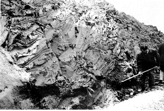
clay appcarcd relat~vely uniform; lunlps o l tllc l o r ~ n e r dry surlace crust and odd picccs olwood were scattcred throughout the clay In an crratlc manncr. but l o r ~ n e d onlv a minor Dart of thc total mass. From i ~ s appearance, i t \\.as evident that thc clay had been almost entircly liq~ieficd during the landslide. N o voids, such as one mould expect i l the clay hacl been only partially rernoulded, were obscrved. Figure1
of Plate 2 shows the texture of the clay as revealed by thc escavation.Along a 200-loot length of the trench, sam- pling and "inspection vane" testing (Andresen and Sollie, 1965) a7cre carried o u t a t 20-foot in- tervals about 3 feet above the buried peat layer. T h e average nlater coiltent of the recoilstitutcd clay was about 65 per ccnt, and its undrained shear strcngth ranged l r o ~ n one half to three quartcrs of thc strength of the clay from the upper terrace. This may be compared to an average water conlent ot
71
per cent and shear strcngth of 1600 psf measured in a boring talccn on the upper terrace of the clay.T h c original soil proble consisted o l a layer of Ileaty material, varying in thickness from
2
inches to more than a foot, lying over natural clay. This natural clay sho~ved no evidence of leaching or oxidation. T h e profle could be de- scribed as a peat phase of a glcy soil. T h e peat itself was co~nposed o l moody fragments and debris typically round on a forest floor. O n top of the peat layer was the debris of the forest standing a t the time of the earth flow. T h e general orientation of the debris was northern, indicating that the trees had been struck by an onrushing n7ave of liquid clay fro111 the land- slide. Figure 2 of Plate
2
sho\vs the position of such a fallen tree. 'I'his previous forest had very Geological Society of America Bulletill, v. 75,p.
1183-1184, 2 pls., September 19671181
W. J. EDEN-BURIED SOII> PROFILE UNDER AI'RON O F AN EARTI-I PLOWshallow root devclopment confincd largely t o T h e observations described in this paper indi- the peat layer, again indicating very wet sur- cate that very wet conditions existed a t t h e face conditions. T h e peat layer and forest de- time of the landslide, which is in accordance bris are being studied in detail by the Paly- with the requirements for a slope stability anal- nology Laboratory of the Geological Survey of ysis.
Canada.
References
Cited
Andresen, A., and Sollie, S., 1965, An inspection vane, p. 8-18 in Vane shear and cone penetration re- slstancc testing in in jilzi soils: Am. Soc. Testing and Materials Special Tech. Pub. 399, 47 p. Crawford, C. B., and Eden, W. J., 1967, Stability of natural slopes in sensitive clay: Jour. Soil Mech.
Found. Div., Am. Soc. Civil Engineers Proc., v. 93, no. SM 4
SOIL MPCIIANICS SEC.I.ION, DIVISION OF BUILDING RESEARCH, NATIONAL R E S E ~ R C I . I COUNCIL UP
CANADA, OTTAWA, CANADA
MANUSCRIPT RECEIVED BY TIIE SOCIETY APRIL 28, 1967
PUULIC,\TION AUTHORIZED BY THE DIRECTOR, DIVISION OF BUILDING RESEARCII, NATIONAL RESEARCI.~