HAL Id: hal-03200952
https://hal.archives-ouvertes.fr/hal-03200952
Submitted on 17 Apr 2021
HAL is a multi-disciplinary open access archive for the deposit and dissemination of sci-entific research documents, whether they are pub-lished or not. The documents may come from teaching and research institutions in France or abroad, or from public or private research centers.
L’archive ouverte pluridisciplinaire HAL, est destinée au dépôt et à la diffusion de documents scientifiques de niveau recherche, publiés ou non, émanant des établissements d’enseignement et de recherche français ou étrangers, des laboratoires publics ou privés.
A post Younger Dryas Black Sea regression identified
from sequence stratigraphy correlated to core analysis
and dating
G. Lericolais, F. Guichard, C. Morigi, A. Minereau, I. Popescu, S. Radan
To cite this version:
G. Lericolais, F. Guichard, C. Morigi, A. Minereau, I. Popescu, et al.. A post Younger Dryas Black Sea regression identified from sequence stratigraphy correlated to core analysis and dating. Quaternary International, Elsevier, 2010, 225 (2), pp.199-209. �10.1016/j.quaint.2010.02.003�. �hal-03200952�
Pleas e note th at this is an aut hor-pr oduc ed PDF of an article a cce pted for publ icatio n foll owin g pe er revi ew. T he defin iti v e pu b lish e r-a uthentic ated ve rsion is av ail a b le on the pub lis her W eb site 1 Quaternary International
October 2010, Volume 225, Issue 2, Pages 199-209
http://dx.doi.org/10.1016/j.quaint.2010.02.003
© 2010 Elsevier Ltd and INQUA All rights reserved.
Archimer
http://archimer.ifremer.fr
A post Younger Dryas Black Sea regression identified from sequence stratigraphy correlated to core analysis and dating
G. Lericolaisa, *, F. Guichardb, C. Morigic, A. Minereaud, I. Popescue and S. Radane
a
IFREMER, Géosciences Marines, Centre de BREST, BP 70, F-29200 Plouzané cedex, France
b
LSCE, CNRS-CEA, Avenue de la Terrasse, BP 1, F-91198 Gif-sur-Yvette cedex, France
c
Geological Survey of Denmark and Greenland (GEUS), Øster Voldgade 10, 1350 Copenhagen, Denmark
d
Asterie, 36 quai de la douane, F-29200, Brest, France
e
GeoEcoMar, 23–25 Dimitrie Onciul Str, BP 34-51, RO-024053 Bucuresti, Romania
*: Corresponding author : G. Lericolais, email address : gilles.lericolais@ifremer.fr
Abstract:
The north-western Black Sea shelf is the widest continental shelf of the Black Sea, where the Danube delta/prodelta system includes important records on the Black Sea water level fluctuations. This study integrates newly acquired high-resolution single channel seismic reflection profiles and Calypso piston cores recovered along a transect extending from the Danube delta deep into its deep sea fan. The correlated results provide information on the Late Quaternary architecture of the Danube Black Sea shelf and on the role of global glacio-eustatic fluctuations on the building of the Danube delta/prodelta. The sedimentary sequences in the Black Sea are strongly affected by water level changes. For the whole duration of Late Glacial–Holocene period, the level of the Black Sea was controlled by the regional climate modifications rather than the global eustatic changes. The seismic sequences recognized on a very high-resolution seismic profile were dated by two Calypso piston cores. Based on the obtained data, during the Last Glacial Maximum the Black Sea was a land locked lake with the level below −120 m. In the course of the deglaciation the lake level rose up to −40 m, which is confirmed by occurrence of the prodelta lobes formed after the rise in water level originated from the melt water. Following the Younger Dryas, 11 000–8500 14C BP, there occurred a new level lowering to the level of −100 m, identified by the forced regression deposits recorded on the Romanian shelf. This last lowstand previously recognized by a pronounced shoreline with a characteristic beach profile and a belt of coastal dunes is also indicated by the prodelta at −100 m depth. All these coastal features as well as the incised anastomosed channel system remained preserved on the shelf resulting from a rapid ultimate transgression starting immediately after 8500 14C BP.
1 INTRODUCTION
Important oceanographic investigations focused on the last deglacial Black Sea sedimentary systems and on its reconnection with the Marmara Sea were carried out for more than 10 years using digital geophysical methods (Aksu et al., 2002a; Aksu et al., 2002b; Aksu et al., 1999; Aksu et al., 2002c; Algan et al., 2007; Algan et al., 2002; Bahr et al., 2006; Bahr et al., 2005; Bahr et al., 2007; Ballard et al., 2000; Di Iorio and Yüce, 1999; Genov, 2004; Giunta et al., 2007; Gökaşan et al., 1997; Gorur et al., 2001; Hiscott et al., 2007; Ion et al., 2002; Kerey et al., 2004; Lamy et al., 2006; Lane-Serff et al., 1997; Lericolais et al., 2002a; Lericolais et al., 2007a; Lericolais et al., 2007b; Lericolais et al., 2002b; Major et al., 2002a; Major et al., 2006; Major et al., 2002b; Marret et al., 2007; Panin and Popescu, 2007; Popescu et al., 2004; Popescu et al., 2001; Ryan, 2007; Ryan et al., 1997a; Ryan et al., 1997b; Siddall et al., 2004; Strechie et al., 2002; Tsimplis et al., 2004; Winguth et al., 2000; Yanko-Hombach et al., 2007). Since first publications of these results, the evolution of the Black Sea following the last glacial became in the focus of scholarly attention. This implied an animated debate between different hypotheses concerning this last glacial evolution. These hypotheses varied from a suggestion of a continuous Black Sea outflow during the entire Last Glacial and Holocene (Kvasov and Blazhchishin, 1978) to the isolation of a low level Black Sea until the early Holocene (Ryan et al., 1997). Then, a multitude of intermediary versions of highstands and lowstands in between were proposed. The final linkup of the Black Sea was seen as either a gradual (e.g. Aksu et al., 1999, 2002), or a catastrophic (e.g. Ryan et al., 1997), or possibly oscillating (e.g. Yanko-Hombach, 2007 and Dolukhanov et al., 2009). The result was a dazzling number of Black Sea level curves, based both on new results and on refreshed analyses of previous less accessible articles, which have literally flooded the literature of the last decade providing overwhelming evidence for the complexity of the Black Sea environment.
Most of the sediments accumulated on continental shelves are generated inland and transported by fluvial systems. The north-western Black Sea continental shelf is marked by an important Delta mouth which has been studied for decades: the Danube Delta (Giosan et al., 1997; Giosan et al., 2006; Giosan et al., 2005; Klyushina, 2005; Panin, 1972; Panin, 1974; Panin, 1989; Panin, 1996; Panin and Jipa, 2002; Panin et al., 1983). The deltas feature a complex morphology resulting from a dynamic equilibrium between fluvial discharge, marine energy conditions, accommodation, and the overall geological framework. In shore-normal sections, late-Holocene prodeltas like the Danube one take the form of thick mud wedges (up to several tens of metres in thickness), large shallow-marine features offshore river mouths and are characterised by significant mud accumulation below the storm wave base. The Danube prodelta represents a good stratigraphic and historical archive of short-term environmental changes and of its catchment's basin water level fluctuations. The offshore pinch-out of prodelta deposits occurred at the depth of several tens of metres. The evidence obtained from improved geophysical investigations in very shallow waters can effectively integrate information from sediment cores and hence identify small-scale stratigraphic features and reveal high frequency water level fluctuations.
The north-western Black Sea continental shelf is the most extended one in this entire anoxic catch basin, and is much less neotectonic affected, in comparison to its eastern part which corresponds to the toe of the Caucasus (Meisner et al., 2009). The Black Sea semi-enclosed basin had a very specific behaviour in response to the Quaternary climatic cyclicity. Actually, during the last Ice Age it formed a low salinity oxygenated lake isolated from the Mediterranean (Ross and Degens, 1974). Its location between Europe and Asia implies that its water level depended on the Eurasian climatic fluctuations. During the glacial periods, the Black Sea became isolated from the Global Ocean and hence was more sensitive to climate changes, like the Caspian Sea that provides today a perfect paleoclimate archives. The Black
Sea avoided the hysteresis effect, the latent period, during which the Global Ocean responded to the melting of the ice. During the Ice Age, while the Black Sea was isolated from the Global Ocean (and the Mediterranean Sea), both the lack of saltwater and the increase of fresh water influx from the rivers, led to a decrease in the salinity of the Black Sea. This behaviour related to the level fluctuation is evidenced by the fauna succession showing a rapid change from salt to semi-brackish species (Bukry, 1974). Since 1997, arose a yet unsolved controversy concerning the last connection of the Black Sea with the Marmara Sea. This question is still under debate, as the Black Sea was not totally surveyed with the use of state-of-the-art technology. Recently the ASSEMBLAGE EU Project (EVK3-CT-2002-00090) provided the assessment of the Northwestern part of the Black Sea sedimentary systems, including the continental shelf and the slope ranging down to the deep-sea zone.
The complex Danube delta/prodelta situated between continental and marine environments forms the key area to resolve this issue. The built-up of such a complex may be attributed to two main forcing factors: first, the eustatic variations controlling the accommodation space and the base level position, and, on the other hand, the sedimentation linked to the climatic variability and to the transportation capacities of river channels. The studies of sequence stratigraphy demonstrate that the delta lithostratigraphy always feature the succession of retrograding, aggrading, and then prograding facies. Seaward of the delta lies the prodelta; the subaqueous fine-grained component of the deltaic system being largely below sea-level. This body is sensitive to sea level change and alterations to its basin and provides information of the water level fluctuations.
Here below, we present results from integrated Very High Resolution (VHR) seismic surveys, recorded offshore of the Danube prodelta ranging from water depths as shallow as 5 m to the toe of an important lowstand wedge identified during BlaSON cruises (Lericolais, 2002) and cored during ASSEMBLAGE cruises (Lericolais and Assemblage partners, 2004).
Important information on recorded Black Sea water level fluctuation is obtained based on the single seismic transect shot from the Danube delta down to the deep sea fan and from two piston cores (12.38 and 7.3 m long) recovered on this transect. A succession of depositional sequences and eroded phases were evidenced and the stacking pattern supported by age dating of the cores from the Last Glacial Maximum (LGM) onwards.
Principles of seismic stratigraphy of marine silliciclastic margins were used to interpret this transect. This method was first applied in the 1970s (Vail and Mitchum, 1977) to unveil the manner in which the sediments accumulate and remain preserved throughout successive sea level cycles. Chiocci et al. (1997) reported similarities in seismic facies and prograding stacking patterns from different locations along the western Mediterranean margin, and proposed a general relationship between the sequence boundaries and 100–120 ka glacio-eustatic oscillations. Correlated with the long cores provided by the ASSEMBLAGE European Project (EVK3-CT-2002-00090), it reveals that since the LGM, the Black Sea evolution was triggered by several important paleo-environmental changes highlighted by a succession of lowstand and highstand systems tracts:
2 METHODS
The data we use for this study have been acquired during surveys realised in the frame of 2 main projects; (1) BlaSON: a French-Romanian bilateral project for which two surveys coordinated by IFREMER were carried out on board the French RV "Le Suroît" in 1998 and 2002, (2) ASSEMBLAGE: a 5th FP European project for which 2 surveys on board the French
RV "Le Marion Dufresne" in 2004 were carried out. For all these surveys a differential GPS system was deployed for accurate (about 1 m) positioning. The RV "Le Suroît" was equipped with EM1000 and EM300 swath bathymetry systems and the RV "Le Marion Dufresne" with a multibeam echo-sounder (MBES) Thomson Seafalcon 11. Very high-resolution seismic lines were shot simultaneously using a Chirp sonar system. All data acquisition were synchronized and digitally recorded. The part of the studied area presented here is displayed in figure 1.
The very high-resolution seismic sources were hull mounted Chirp Sonar systems with frequencies ranging between 1.5 and 7 kHz. Their vertical resolution is less than 1 m with a penetration reaching 500 ms in some deep areas where the sediment cover is constituted of soft sediment. On the shelf the presence of gas bearing sediments masking the information beneath ca 20 m depth bsf decreases the amount of usable data.
Figure 1: Northwestern Black Sea shelf presenting the location map of the seismic line B2CH96 (AB) and of the cores MD04-2771 and MD04-2774, along with geomorphologic interpretation issued from previous
work (Lericolais et al., 2007b; Popescu et al., 2004; Popescu et al., 2001). DD = Danube Delta,
PDR1 and PDR2 = Paleo-Danube River 1 and 2 PCL = Paleo Coastline
VC = Viteaz Canyon DSF = Danube Deep Sea Fan
In this paper, the presented seismic line is the Chirp B2CH096 profile shot during BlaSON2 survey (figure 2). Analysis of the Chirp data is based on two distinct steps: (1) a seismic data processing phase using IFREMER software with a conventional processing flow
including pass-band filtering, bottom multiple attenuation and signal envelope amplification, and (2) interpretation of the seismic line using high resolution sequence stratigraphy principles (Chiocci et al., 1991; Lericolais et al., 1990).
Figure 2: Line B2CH96 with core location (vertical exaggeration is ca. 200) DPD = Danube Prodelta
PCL = Paleocoastline LSW = Low-Stand Wedge
We present results obtained on cores MD04-2771 and MD04-2774 (figure 3). The sediment cores have been recovered using a Kullenberg piston corer of Calypso type developed for IPEV (French Institute for Polar Research) and allowing long tube (up to 60 m) system. The corer is deployed with an aramide cable (specially designed for oceanographers with non-rotational technology), which is virtually weightless in water. The corer consists of a trigger (piston), weight (1 to 7 tons), corer pipes (metal tube with transitions), core catcher and cables. The core liner is extracted and cut into 1.5 m long sections. Each of the sections were cut horizontally into two pieces and scanned to get an image before performing the sample analyzing. The general properties of the sediments were measured by the Multi System Track (MST) to get p-wave velocity and amplitude, density, impedance and magnetic susceptibility values. All cores were packaged at 4°C and sampling were realised at the IFREMER Brest laboratory. Dating were done on samples at various distances and various depths from the coast allowing revealing a possible bias in ages due to coastal or current influence. The Poznań Radiocarbon Laboratory in Poland performed 14C dating. Even if, at
least for the more recent period, Siani et al (2000) have proposed a reservoir age of 415±90 years BP for the Black Sea, based on 6 collected shells from the Black Sea, the sea of Marmara and in the vicinity of the Bosporous, uncalibrated and uncorrected 14C ages are used throughout this study. One of the reason for this is that a reservoir age of about 1280 years was deduced from the occurrence of the Santorini Minoan ash in the Unit II of Jones and
Gagnon (1994) of several south Black Sea cores recovered between 400 and 700 m below present sea level (Guichard et al., 1993).
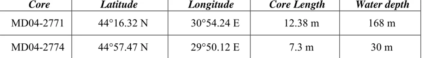
Core Latitude Longitude Core Length Water depth
MD04-2771 44°16.32 N 30°54.24 E 12.38 m 168 m
MD04-2774 44°57.47 N 29°50.12 E 7.3 m 30 m
Table 1: Cores presented in this study with their position, length of recovery and water depth at location
Figure 3: Logs for the cores used in this study MD04-2771 and MD04-2774. Core location, length and water depth are given in table 1. 14C ages are uncorrected ages (cf. Table 2).
3 RESULTS AND INTERPRETATION
Interpretation of high and very high resolution reflection seismic data allowed to establish a seismic stratigraphic model of the northwestern Black Sea shelf (Winguth et al., 2000) and to evidence major sediment facies deposited on the shelf since the Last Glacial Maximum. The core analyses brought also their information on the sedimentary facies encountered in the Black Sea.
3.1 Sedimentary Facies
Figure 4: Repartition of litho-stratigraphic units on the sea floor (from S. Radan, unpublished data).
Before the work realized within the ASSEMBLAGE project, we considered the results obtained from previous studies. The first ones which came with a Black Sea facies zonation (Arthur and Dean, 1998; Arthur, 1988; Hay et al., 1991; Ross et al., 1970; Ross and Degens, 1974) were deduced from deep sea core analyses. These authors defined 3 lithological units on the base of the presence/absence of laminations, color and grain-size. This division corresponds from the bottom to the top of the core to different environmental situations that occur since the last Glacial maximum in the Black Sea: the lacustrine period testified by an alternation of light and dark lutite sediments (Unit III), the black-dark sediments corresponding to the sapropel deposition (Unit II) and the youngest unit (Unit I), an alternating sequence of dark and white lamina.
On the continental shelf, Shcherbakov and Babak (1979) have defined a sedimentary repartition which has been used to classify the continental shelf presented in figure 4.
Modiolus mud: The Modiolus mud is located at the top of the sedimentary sequence between 50 to 125 m of water depth. It corresponds to light coloured
mud, very rich in Modiolus phaseolinus coquinas and whose thickness does not normally exceed more than 30 cm.
Mytilus mud: The Mytilus (Mytilus galloprovincialis) mud is present from the shelf break till the depth of 50 to 40 m, it is after that recovered by the Modiolus Mud
Dreissena mud: Around 130 m of water depth the surficial sediments are made of shells of Dreissena. Landward, this unit is covered by the Mytilus mud and by the Modiolus mud. They are outcropping only at the top of the slope.
The vertical transition between Dreissena mud to Mytilus mud corresponds to the transition between semi-brackish to marine conditions in the Black Sea.
Giunta et al. (2007) define the biostratigraphy of the cores allowing correlation between deep sea cores and the shallower cores collected on the shelf. Variation in abundance and composition of calcareous nannofossil assemblages allow to define bioevents clearly traceable throughout the basin despite large sediment facies changes. The ecozones are characterised by spotty occurrence (ecozone 3), presence (ecozone 2) and local acme of Emiliania huxleyi (ecozone 1). They roughly correspond to the 3 lithological units defined in the deep sea cores, whereas in the shelf cores ecozone 3 corresponds to the alternation of light and dark lutite sediments (Unit III) and ecozone 2 and 1 correspond to shell hash layer overlain by the Mytilus and Modiolus mud.
3.2 Seismic Stratigraphy
3.2.1 Lowstand system tracts
Figure 5: Chirp profile B2CH96: Distal part of Figure 2. LSW1 and LSW2 can be distinguished; base of US2 is marked in red and in green is the mud drape
On line B2CH96 at around 150 m bsl, prograding parallel but undulated reflectors are evidenced and characterise a seismic Unit LSW1 (figure 5). These reflectors terminate on
toplap at the top of LSW1. Above the erosional truncation is Unit LSW2 presenting reflectors bevelling the slope slightly northwestwardly the LSW1.
Landward, around the water depth of 100-110 m, another prograding wedge is interpreted (figure 6). This prograding wedge is correlative of the forced regression termination described by Lericolais et al. (2006; 2009) on a dune field recognized southerly of the Viteaz canyon. This last prograding sequence is truncated eastward by the wave cut terrace (WCT on figure 6). All over the seismic line is a thin unit which corresponds to the mud drape known to be present all over the western Black Sea (Lericolais et al., 2007a; Major et al., 2002b; Ryan et al., 2003; Ryan et al., 1997a).
Figure 6: Chirp profile B2CH96: Median part of figure 2. The prograding wedge (FR = Forced Regression) is truncated by the wave cut terrace (WCT) described by Major et al. (2002b), Ryan et al. (2003)
and Lericolais et al. (2007a, 2009)
3.2.2 Danube prodelta
At the coastal part of the Danube delta is its prodelta. Here on the Chirp seismic profile, a ravinement surface R1 is identified (figure 7). Above is a prograding wedge US2 well delimited on the Chirp seismic data; this wedge corresponds to a former prodelta lobe (as it will be confirmed hereafter by the results of the dating on core MD04-2774). Another prodelta lobe corresponding to seismic unit US3 presents reflectors onlapping on the previous unit US2. The geometric relationship between these prodelta lobes would have been best imaged on shore-parallel profiles showing in detail the lap out patterns of seismic reflectors like it has been done for the Po river prodelta by Correggiari et al. (2005a; 2005b).
Units US2 and US3 represent the sites of deposition and progradation at the distal part of the previous Danube river outlets and channels. These prodelta lobes represent part of the main depocentres that extend offshore, being a considerable portion of the prodelta deposit (Correggiari et al., 2005a; Correggiari et al., 2005b).
Figure 7: Prodelta section of line B2CH96 with location of core MD04-2774: R1 is a ravinement surface, US2 is a prograding wedge interpreted as a former prodelta lobe. US3 is a retrograding sequence on US2 and
can be a second prodelta lobe. US4 is a prograding sequence to be correlated to the Forced regression described at -100 m by Lericolais et al. (2006). US8 is the present day prodelta deposit.
Above these prodelta lobes, seismic unit US4 is prograding also but in a more gentle shape. This unit can also be interpreted as a prodelta lobe or fluvial deposit, but ages obtained on core MD04-2774 return an average age of ca. 9500 yr 14C BP (see table 2). Sediment analysis and presence of Pisidium (figure 3), a genus of very small or minute freshwater clams, aquatic bivalve molluscs in the family Sphaeriidae, would confirm this last assumption. This unit is contemporaneous to the onset of the Pre-Boreal regression (11000 to 8000 yr 14C BP) and
could be interpreted as contemporaneous of the forced regression set presented on the southern dune field (Lericolais et al., 2006; Lericolais et al., 2009). MD04-2771 core study confirms hereafter the fluvial characteristics of this unit. Above is the present-day delta system of the Danube with an important prodelta lobe identified on the seismic line as unit US8. Here the mud drape covers US8, but can only be distinguished on core MD04-274. As the Danube delta is still active, recent fluvial sedimentation is still present at its present prodelta part.
3.2.3 Shelf wide unconformity
Except for the recent prodelta lobe, the entire shelf is covered by a uniform mud drape. Underneath is a shelf wide unconformity that has been identified in more than 100 cores recovered during the European Project ASSEMBLAGE (http://www.ifremer.fr/assemblage). This washout layer is interpreted as the last unconformity and the change corresponds to a stratigraphic break (“washout”) in the cores that interrupts the lacustrine calcite precipitation and is followed by terrigenous mud with marine molluscs. This “washout” layer was already interpreted in (1991) by Bulgarian scientists: Khrischev and Georgiev, who published a "Regional washout on the Pleistocene-Holocene Boundary in the western Black-Sea
depression". They propose that a possible “fast raising” of the water level during the transition from lacustrine to marine conditions in the Black Sea could have lead to “a drastic change of the sedimentation environment” coincident with the establishment of the connection with the Mediterranean through the Bosporus. For these authors such "a regional washout with such a wide area development poses difficult problems for its interpretation". In all the cores they recovered in the North-western Black Sea, a sharp line marks the washout layer, uneven sometimes and with an irregular layer of fine silt to sandy silt directly above it. This washout layer has also been described by Dimitrov (1982), Major et al. (1994; 2002b), Ryan et al. (2003; 1997a); Lericolais et al. (2007a; 2003) as the “hash layer” as it is constituted by shell debris of Dreissena in majority all whitened. Today this washout is presence on the present day beach just at the surf zone. It marks the highstand deposit. Its presence in all the cores recovered along the continental shelf, witnesses the transgression and this layer can correspond to the ravinement surface.
3.2.4 Uniform drape above the unconformity
As already described in previous sedimentological studies in the Black Sea (Algan et al., 2002; Lericolais et al., 2007a; Lericolais et al., 2007b; Major et al., 2002b; Ryan et al., 2003; Ryan et al., 1997a), an uniform mud drape is deposited above the unconformity along the Black Sea margin. This mud drape layer was sampled during BlaSON and ASSEMBLAGE surveys, it corresponds in cores to the layer of terrigenous mud containing marine molluscs such as Mytilus galloprovincialis and edulis, Cerastoderma edule and Cardium edule (Lericolais et al., 2007b). This lithologic and biostratigraphic interval on the shelf corresponds to Units 1 and 2 in basin sediments as defined by (Ross et al., 1970).
3.3 Lithology, chronostratigraphy, and seismic and core stratigraphic correlation Core Water depth Core Length
Depth in core Age 14C BP (years) Calibrated age*(years) Sample Unit MD04-2771 168 m 12.38 m 0.34 m 12180 ± 60 13650 ± 120 Dreissena LSW2 2.18 m 24980 ± 160 28840 ± 180 Dreissena LSW1 11.90 m 29450 ± 320 - organic matter LSW1 MD04-2774 30 m 7.3 m 5.43 m 9030 ± 50 9720 ± 140 Pisidium US4 6.91 m 9570 ± 50 10440 ± 90 Pisidium US4
Table 2: Dates obtained on the cores presented in this study, and type of samples dated (mollusk or organic matter). * Calibrated age are here as indicator and are obtained using the Radiocarbon Calibration Program
Calib5 (Stuiver et al., 1998) with 400 yrs for reservoir correction.
Lithological logs of the presented cores are displayed figure 3. The ages obtained on core MD04-2771 and MD04-2774 are from carbon-14 Accelerator Mass Spectrometry (AMS) dating of fauna sampled from these cores (Table 2). Our 14C dating, ages as presented here are in raw carbon 14 years before 1950 and these dates are neither corrected for reservoir age nor calibrated to tree rings. By using raw values, comparisons can be made with 14C dates
published long before corrections and calibrations were applied.
If we include documentation from Jones & Gagnon (1994), Bahr et al. (2005) and Kwiecien et al. (2008), then reservoir ages are extending from 400 to 1280 years. For the lacustrine period no measurement has been proposed for the past. If no terrestrial influence exists, then age and residence time of deep waters will play the main factor. Östlund (1974) calculated ages of deep waters between 1470 years (at about 600 m) and more than 2000 years (when deeper than 1400 m). If a low stratification occurs in poorly salted water then the residence time would be equal or less than 935 years. The question of which reservoir age could be given to old water of the "Black Lake", depending on depth in the water column is still a matter of debate and it is the reason why we are still using uncalibrated ages for our obtained dates (Fontugne et al., 2009). Nevertheless, as explained in Table 2, calibrated age are provided for this table as indicator only. They are obtained using the Radiocarbon
Calibration Program Calib5 (Stuiver et al., 1998) with 400 yrs for reservoir correction. But, they are only indicator, as now any premature reservoir age correction may be invalid.
The dating of some of the seismic units interpreted were made possible and older dates reach back to 29450 yr 14C BP for Unit LSW1 at 11.90 m on core MD04-2771. This date is obtained on organic matter but as the date return by a Dreissena shell sampled at 2.18 m in the same core returned a date of 24980 yr 14C BP, we can be confident in attributing the
deposition of LSW1 during the Last Glacial period. 4 DISCUSSION
Correlation between sequence stratigraphy and age dating made on one specific transect from the Danube prodelta down to the shelf-break and slope allows evidencing of lowstand wedges on the transect and determining age control on the prodelta formation since the LGM. Actually, the older seismic unit evidenced in this study is Unit 1: LSW1 (age ranging between 29450 ± 320 and 24980 ± 160 yr 14C BP). The older obtained age is from organic carbon and could not be used to date LSW1 age, but give an idea of the age of the matrix where the in situ Dreissena shell has been found and dated. These dates together with the sequence stratigraphy interpretation confirm that the LSW1 corresponds to a lowstand wedge deposited during the Last Glacial Maximum around 21 000 years cal BP. This period of deposit is under semi-brackish conditions which prevailed in the Black Sea during LGM. The Black Sea salinity during the LGM was ranging between 4‰ to 7‰ salinity (Major et al., 2002a; Manheim and Chan, 1975; Marret et al., 2007). This is also the period of time when the last important Danube Deep Sea Fan channel-levees were set (Popescu et al., 2001).
US2 interpreted as a prograding wedge at the Danube prodelta location corresponds to a former prodelta lobe. Unfortunately core MD04-2774 did not reach the lobe itself but reach an upper limit confirming that this prodelta lobe is not a contemporaneous construction. This unit lays on R1 interpreted as a ravinement surface. This ravinement surface is probably
correlative to the onset of the red layer deposits described by Major et al. (2002a), Bahr et al. (2005) and Bahr et al. (2006) which correspond to the water influx issued from the post LGM ice melting.
US3 reflectors are onlapping on US2. This retrograding shape can be interpreted for US3 to be a transgressive system tract. However, autocyclic factors are important in delta settings, and as for the Po prodelta, US3 corresponds most probably to a secondary prodelta lobe (Correggiari et al., 2005a; Correggiari et al., 2005b) sitting on US2. This prodelta complex was built up after the increase of fresh water influx to the Black Sea from the rivers that were draining the ice caps and preceding the onset of US4 returning an age of 9030 ± 50 and 9570 ± 50 yrs 14C BP obtained on fresh mollusc shells. This unit is described as a fluvial unit by
Minereau (Minereau, 2006), confirmed by the fauna recovered in the core. This unit can also correspond to the delta front amalgamated sands and muds of the early Holocene lobe interpreted by Giosan et al. (Giosan et al., 2009). More core analysis and longer ones could determine if this unit is located at a delta front or upstream in the delta plain. Nevertheless, this age is in accordance with the ages returned by the forced regression sequences described by Lericolais et al. (2009). Their distal part is eroded by the wave cut terrace described figure 6. Although no core was collected at this location, this "berm" can be followed in the bathymetry (PCL on figure 1) and age of the wave cut terrace is given to be between 8500 to 8000 14C BP by Lericolais et al. (2009). At the beginning of this regression is the onset of LSW2 a low stand wedge which shape is characteristic of low energy wedge. Core MD04-2771 confirms that this lowstand wedge started to deposit around 12180 ± 60 yr 14C
BP. Eris et al. (2007) suggested that the Black Sea lowstand started at the Younger Dryas which is a little bit earlier to what we obtained here, if we apply 400 yrs for reservoir correction using the Radiocarbon Calibration Program Calib5 (Stuiver et al., 1998). This
slight discrepancy confirms that Black Sea age reservoir studies are necessary (Fontugne et al., 2009; Kwiecien et al., 2009).
Above and present in almost the cores described on the continental shelf of the north-western part of the Black Sea is a layer made of debris of Dreissena shells. This layer has been dated by ASSEMBLAGE EU project and published in Lericolais et al. (2007b). The age obtained range between 8760 ± 40 and 8620 ± 50 yr 14C BP. Equivalent “hash layer” is
present nowadays at the surf zone of the Black Sea. Algan et al. (Algan et al., 2006) made also the observation of dense, dry mud below the erosional unconformity on the Thrace margin. These authors note “a marked contact” between a 2-cm thick shell-enriched layer and a “stiff clay deposit with low water content at the base of these cores”. The 14C age of the
shells (dreissena sp.) is 8590 ± 145 yr 14C BP comparable to the age of the shell material on
top of the sand ridges on the Romanian shelf at the paleo-Danube course described by Lericolais et al. (2007b). Algan et al. (2006) consider that “the lithological characteristic of this core indicates that the deposition starts with high-energy condition over the stiff eroded substrate at about -100m, and continued with low-energy, suggesting a rapid deepening of a shallow environment”. This firm clay with bulk densities in the range of 2.0 ± 0.1 g/cm3 was
also recovered near the shelf break on the Romanian margin in several cores from the BlaSON Expedition with 14C dates in samples taken right below the erosion surface ranging
from 10250 to 24160 yr 14C BP (Major et al., 2002b). The physical properties measured in every core featured that the contact between overlying water-saturated mud and the underlying stiff clay was abrupt and occurred in the span of 1 to 2 cm. The only measured cores without the dense substrate were those taken in water depths below -160m.
US8 is the present day prodelta deposit, at its distal part; the mud drape is covering the present sequences.
CONCLUSION
The level of the Black Sea followed to a certain extent more the regional climate modification than the global eustatic changes. It has long been recognised that the Black Sea was isolated from the Mediterranean Sea during the last glacial interval when the level of the Black Sea and the Mediterranean dropped far below the level of the Bosphorous sill (e.g., during the last glacial, about 20000-18000 yr BP, the level of the Black Sea dropped to at least -120 m). During the Last Glacial Maximum, 21000 years ago, the Black Sea was probably a giant freshwater lake as proposed by (Arkhangelskiy and Strakhov, 1938) or at least a semi-brackish enclosed basin. Its water level stood more than 120 m below than today's level. During the ASSEMBLAGE (EVK3-CT-2002-00090) European project, analysis of chirp high-resolution seismic reflection profiles together with piston core analyses from surveys realised on the Black Sea shelf provided new insight into recent sedimentation processes. This is confirmed by the presence of lowstand wedge (LSW1) evidenced from one transect acquired from the prodelta down to the bathyal plain during BlaSON cruises and dated after the core recovered during ASSEMBLAGE survey results. But nothing was confirmed for the previous glacial interval, even with the long core results, we were only able to point the long lacustrine varve deposits in the Black Sea. Once separated from the Mediterranean basin, the level of the Black Sea fluctuated according to the regional climate and water supply independently of changes in the global oceans.
The postglacial warming and melting of ice caps which started 15000 yr BP resulted in a general rise of the Black Sea water level. As the Black Sea was in very close vicinity to the Scandinavian-Russian ice cap, the melting water from the glaciers were supplied into the Black Sea through the major drainage system constituted by large European rivers (Danube, Dniepr, Dniestr and Bug). This supply was assimilated to the reddish layers described in cores (Bahr et al., 2005; Major et al., 2002b; Strechie et al., 2002). The water brought to the Black
Sea after the Melt Water Pulse 1A (MWP1A) at approximately 12500 yr B
14
BC BP (14500 Cal
yr BP; (Bard et al., 1990)) was supposed to be sufficiently important for the water level to rise until 40 m below the present day sea level. This high-stand system tract can be associated with the Bölling-Allerod Black Sea high-stand. The isobath 40 m up limit is interpreted from the prodelta complex (US2 and US3) built up after the increase of fresh water influx to the Black Sea. This limit is a little bit deeper than 20 m limit certified by Valentina Yanko-Hombach (Yanko, 1990). This last value for the transgression upper limit would have brought the level of the Black Sea to even higher than the Bosphorus sill and the possible inflow of marine species like Mediterranean dynoflagellate populations could be envisaged (Popescu, 2004). Palynological studies conducted on BlaSON cores (Popescu, 2004) show that during the Younger Dryas, a cool and drier climate prevailed. At that time, the North-eastern rivers converged to the North Sea and to the Baltic Ice lake (Baltic Sea) (Jensen et al., 1999) resulting in reduced river input to the Black Sea having for consequence a receding shoreline. These are consistent with some evaporative drawdown of the Black Sea and correlated to the evidence of an authigenic aragonite layer present in all the cores studied (Giunta et al., 2007; Jermannaud, 2004). At that time is the beginning of the onset of the second lowstand wedge (LSW2) which shape is characteristic of low energy wedge. This is consistent with the onset of a second regressive period depositing US4 together with the forced regression system tracts evidenced south of the Viteaz Canyon by Lericolais et al. (2009). This terminates by the onset of a low-stand system tract between -120 m and –80 m associated to a second shelf erosional surface formed since the Younger Dryas and marked by a second prodelta. This lowered sea-level in the Black Sea persisted afterwards as implied by (1) the continuously dry climatic conditions in the region having started around 11000 to 8000 yr P
14
PC BP (large percentages of
herbs and steppe elements were described in the cores (Popescu, 2004)), (2) the dune formation between 10000 and 8500 yr P
14
shelf at -100 m depth (Lericolais et al., 2007a), (3) the forced regression sequences dated from lacustrine species installed between 11 to 8500 yr P
14
PC BP (Lericolais et al., 2006; Lericolais et
al., 2009), (4) the wave cut terrace at -100 m water depth posterior to these forced regression sequences. Numerous Russian authors also indicate a sea level lowstand at about -90 m depth, based on the location of offshore sand ridges described at the shelf edge south of Crimea.
To resume, since the LGM the Black Sea evolution was triggered by several important paleo-environmental changes highlighted by a succession of systems tracts:
(1) LSW1 is a low-stand wedge located between -120 to -160 m was formed during the LGM,
(2) US2 and US3 represent prodelta lobes deposited during Bölling-Allerod Black Sea high-stand raising the level of the lake to -40 m,
(3) LSW2 is a second lowstand wedge,
(4) US4 corresponds to the proximal part of the forced regression sequence, which started after 11000 yrs cal. The fresh to semi-brackish species recovered in the core corroborate the lake regression during that period.
(5) FR and WCT (figure 6) are end members of the forced regression (FR) sequences and mark the second lowstand system tract located at -100 m and associated with a shelf erosional surface marked by a wave cut terrace (WCT).
(6) The preserved coastal barriers and paleo-river channels cutting across the continental shelf and the uniform deposit of a hash layer all over the shelf that can be related to a rapid transgression prior to the onset of the highstand prodelta deposit characterised by US8.
ACKNOWLEDGMENT
Our research was supported by the French ministry of foreign affairs within the frame of a bi-lateral collaboration between France and Romania, and prolonged by a European project of the 5P
th
acknowledgement goes to Nicolae Panin who started and supported the project. We also thank Guillaume Soulet for his help in age calculation, the crew of the vessels "Le Suroît" (Ifremer) and "Marion Dufresne" (IPEV) and to Liviu Giosan for his peer review of the manuscript. Special thanks to Yvon Balut.
Aksu, A.E. et al., 2002a. Last glacial-Holocene paleoceanography of the Black Sea and Marmara Sea: stable isotopic, foraminiferal and coccolith evidence. Marine Geology, 190(1-2): 119-149.
Aksu, A.E. et al., 2002b. Persistent Holocene outflow from the Black Sea to the eastern Mediterranean contradicts Noah's Flood hypothesis. GSA Today, 12(5): 4-10.
Aksu, A.E., Hiscott, R.N. and Yasar, D., 1999. Oscillating Quaternary water levels of the Marmara Sea and vigorous outflow into the Aegean Sea from the Marmara Sea Black Sea drainage corridor. Marine Geology, 153(1-4): 275-302.
Aksu, A.E., Hiscott, R.N., Yasar, D., Isler, F.I. and Marsh, S., 2002c. Seismic stratigraphy of Late Quaternary deposits from the southwestern Black Sea shelf: evidence for non-catastrophic variations in sea-level during the last ~10000 yr. Marine Geology, 190(1-2): 61-94.
Algan, O. et al., 2006. Sea-level changes during the Late Pleistocene-Holocene on the southern shelves of the Black Sea. In: V. Yanko-Hombach, A.S. Gilbert, N. Panin and P.M. Dolukhanov (Editors), The Black Sea Flood Question: Changes in Coastline, Climate, and Human Settlement. Springer, New-York (USA), pp. 603-631.
Algan, O. et al., 2007. Sea-level changes during the Late Pleistocene-Holocene on the southern shelves of the Black Sea. In: V. Yanko-Hombach, A.S. Gilbert, N. Panin and P.M. Dolukhanov (Editors), The Black Sea Flood Question: Changes in Coastline, Climate, and Human Settlement. Springer, New-York (USA), pp. 603-631.
Algan, O. et al., 2002. A high-resolution seismic study in Sakarya Delta and Submarine Canyon, southern Black Sea shelf. Continental Shelf Research, 22(10): 1511-1527. Arkhangelskiy, A.D. and Strakhov, N.M., 1938. Geological structure and history of the
evolution of the Black Sea. Izv. Akad. Nauk SSSR, 10: 3-104.
Arthur, M.A. and Dean, W.E., 1998. Organic-matter production and preservation and evolution of anoxia in the Holocene Black Sea. Paleoceanography, 13(4): 395-411. Arthur, M.A.e.a., 1988. Black Sea Sediments (Cap.V.A. ). In: S. Honjo and B.J. Hay (Editors),
Temporal and Spatial Variability in Sedimentation in the Black Sea - Cruise Report - Black Sea Sedimentation Data File, R/V Knorr 134-8, Black Sea Leg 1. Woods Hole Oceanographic Institution, Woods Hole (USA).
Bahr, A., Arz, H.W., Lamy, F. and Wefer, G., 2006. Late glacial to Holocene paleoenvironmental evolution of the Black Sea, reconstructed with stable oxygen isotope records obtained on ostracod shells. Earth and Planetary Science Letters, 241(3-4): 863-875.
Bahr, A., Lamy, F., Arz, H., Kuhlmann, H. and Wefer, G., 2005. Late glacial to Holocene climate and sedimentation history in the NW Black Sea. Marine Geology, 214(4): 309-322.
Bahr, A. et al., 2007. Abrupt changes of temperature and water chemistry in the late Pleistocene and early Holocene Black Sea. G3: 1-29.
Ballard, R.D., Coleman, D.F. and Rosenberg, G., 2000. Further evidence of abrupt Holocene drowning of the Black Sea shelf. Marine Geology, 170(3-4): 253-261.
Bard, E., Hamelin, B., Fairbanks, R.G. and Zinder, A., 1990. A calibration of the 14C timescale over the past 30,000 years using mass spectrometric U-Th ages from Barbados corals. Nature, 345: 405-410.
Bukry, D., 1974. Coccoliths as Paleosalinity Indicators; evidence from Black Sea. In: E.T. Degens and D.A. Ross (Editors), The Black Sea; Geology, Chemistry, and Biology. Amer. Assoc. Petrol. Geol., Tulsa, pp. 353-363.
Chiocci, F.L., Ercilla, G. and Torre, J., 1997. Stratal architecture of Western Mediterranean Margins as the result of the stacking of Quaternary lowstand deposits below [`]glacio-eustatic fluctuation base-level'. Sedimentary Geology, 112(3-4): 195-217.
Chiocci, F.L., Orlando, L. and Tortora, P., 1991. Small-scale seismic stratigraphy and paleographical evolution of the continental shelf facing the SE Elba island (Northern Tyrrenian Sea, Italy). Journal of Sedimentary Petrology, 61: 506-526.
Correggiari, A., Cattaneo, A. and Trincardi, F., 2005a. Depositional patterns in the Late-Holocene Po delta system. In: J.P. Bhattacharya and L. Giosan (Editors), River Deltas: Concepts, Models and Examples. SEPM Special Publication, Tulsa, Okl. (USA), pp. 365-392.
Correggiari, A., Cattaneo, A. and Trincardi, F., 2005b. The modern Po Delta system: Lobe switching and asymmetric prodelta growth. Marine Geology, 222-223: 49-74.
Di Iorio, D. and Yüce, H., 1999. Observations of Mediterranean flow into the Black Sea. Journal of Geophysical Research 104(C2): 3091-3108.
Dimitrov, P.S., 1982. Radiocarbon datings of bottom sediments from the Bulgarian Black Sea Shelf. Bulg. Acad. Sci. Oceanology, 9: 45-53.
Dolukhanov, P.M., Kadurin, S.V. and Larchenkov, E.P., 2009. Dynamics of the coastal North Black Sea area in Late Pleistocene and Holocene and early human dispersal. Quaternary International, 197(1-2): 27-34.
Eris, K. et al., 2007. The timing and evolution of the post-glacial transgression across the Sea of Marmara shelf south of İstanbul. Marine Geol., 243(1-4): 57-76.
Fontugne, M., Guichard, F., Strechie, C. and Lericolais, G., 2009. Reservoir age of the Black Sea waters during anoxic periods Radiocarbon, 51(3).
Genov, I.D., 2004. Way and time of swell formation near the Bulgarian Black Sea shelf. Comptes Rendus de l'Academie Bulgare des Sciences, 57(6): 95-98.
Giosan, L., Bokuniewicz, H.J., Panin, N. and Postolache, I., 1997. Longshore sediment transport pattern along Romanian Danube delta coast. Geo-Eco-Marina, 2(11–24). Giosan, L. et al., 2006. Young Danube delta documents stable Black Sea level since the
middle Holocene: Morphodynamic, paleogeographic, and archaeological implications. Geology, 34(9 ): 757-760.
Giosan, L. et al., 2005. River delta morphodynamics; examples from the Danube Delta. In: L. Giosan and J.P. Bhattacharya (Editors), River Deltas: Concepts, Models, and Examples. SEPM special publications, Tulsa (USA), pp. 3.
Giosan, L., Filip, F. and Constatinescu, S., 2009. Was the Black Sea catastrophically flooded in the early Holocene? Quaternary Science Reviews, 28(1-2): 1-6.
Giunta, S., Morigi, C., Negri, A., Guichard, F. and Lericolais, G., 2007. Holocene biostratigraphy and paleoenvironmental changes in the Black Sea based on calcareous nannoplankton. Marine Micropaleontology, 63(1-2): 91-110.
Gorur, N. et al., 2001. Is the abrupt drowning of the Black Sea shelf at 7150 yr BP; a myth? Marine Geology, 176(1-4): 65-73.
Guichard, F., Carey, S., Arthur, M.A., Sigurdsson, H. and Arnold, M., 1993. Tephra from the Minoan eruption of Santorini in sediments of the Black Sea. Nature, 363(17): 610-612. Hay, B.J., Arthur, M.A., Dean, W.E., Neff, E.D. and Honjo, S., 1991. Sediment deposition in the Late Holocene abyssal Black Sea with climatic and chronological implications. Deep-Sea Research, 38(Suppl.2): S1211-S1235.
Hiscott, R.N. et al., 2007. A gradual drowning of the southwestern Black Sea shelf: Evidence for a progressive rather than abrupt Holocene reconnection with the eastern Mediterranean Sea through the Marmara Sea Gateway. Quaternary International, 167-168: 19-34.
Ion, G., Lericolais, G., Nouzé, H., Panin, N. and Ion, E., 2002. Seismo-acoustics evidences of gases in sedimentary edifices of the paleo-Danube realm. CIESM Workshop series, 17: 91-95.
Jensen, J.B., Bennike, O., Witkowski, A., Lemke, W. and Kuijpers, A., 1999. Early Holocene history of the southwestern Baltic Sea: The Ancylus Lake stage. Boreas, 28(4): 437-453.
Jermannaud, P., 2004. Etude sédimentologique et sismique des dépôts quaternaires de l'éventail profond du Danube. Master 2 Thesis, Université de Bordeaux 1, Bordeaux, 50 pp.
Jones, G.A. and Gagnon, A.R., 1994. Radiocarbon chronology of Black Sea sediments. Deep Sea Research 1, 41(3): 531-557.
Kerey, I.E. et al., 2004. Black Sea-Marmara Sea Quaternary connections: new data from the Bosphorus, Istanbul, Turkey. Palaeogeography, Palaeoclimatology, Palaeoecology, 204(3-4): 277-295.
Khrischev, K.G. and Georgiev, V.M., 1991. Regional washout on the Pleistocene-Holocene Boundary in the western Black-Sea depression. Comptes Rendus de l'Academie Bulgare des Sciences, 44(9): 69-71.
Klyushina, G.V., 2005. River delta morphodynamics; examples from the Danube Delta.; River deltas; concepts, models, and examples. Geologichnyy Zhurnal (1995) = Geological Journal, 83: 393-411.
Kvasov, D.D. and Blazhchishin, A.I., 1978. The key to sources of the Pliocene and Pleistocene glaciation is at the bottom of the Barents Sea. Nature, 273(5658): 138-140. Kwiecien, O. et al., 2009. North Atlantic control on precipitation pattern in the eastern Mediterranean/Black Sea region during the last glacial. Quaternary Research, 71(3): 375-384.
Kwiecien, O. et al., 2008. Estimated reservoir ages of the Black Sea since the last glacial. Radiocarbon, 50(1): 99-118.
Lamy, F., Arz, H.W., Bond, G.C., Bahr, A. and Pätzold, J., 2006. Multicentennial-scale hydrological changes in the Black Sea and northern Red Sea during the Holocene and the Arctic/North Atlantic Oscillation. Paleoceanography, 21(1): PA1008.
Lane-Serff, G.F., Rohling, E.J., Bryden, H.L. and Charnock, H., 1997. Postglacial connection of the Black Sea to the Mediterranean and its relation to the timing of sapropel formation. Paleoceanography, 12(2): 169-174.
Lericolais, G., 2002. BLASON 2 report (available at
http://www.ifremer.fr/sismer/catal/campagne/campagne.htql?crno=2020070).
Lericolais, G., Allenou, J.-P., Berné, S. and Morvan, P., 1990. A new system for acquisition and processing of very high-resolution seismic reflection data. Geophysics, 55(8): 1036-1046.
Lericolais, G. and Assemblage partners, 2004. Assemblage deliverable 9a: MD139-Assemblage1 cruise report ( http://www.ifremer.fr/assemblage/d9a-assemblage1-report.htm), European Community, Energy, Environment and Sustainable Development, Brest.
Lericolais, G., Bulois, C. and Gillet, H., 2006. Forced Regression deposits shaped before the Black Sea Flood. Pseudo-3d very high resolution seismic data interpretation, European Geosciences Union, General Assembly 2006, Vienna (AT), N° CL038-1FR4O-003, Paper N° EGU06-A-01686.
Lericolais, G., Bulois, C., Gillet, H. and Guichard, F., 2009. High frequency sea level fluctuations recorded in the Black Sea since the LGM. Global and Planetary Change, 66(1-2): 65-75.
Lericolais, G. et al., 2002a. Recent canyon heads evidenced at the Bosphorus outlet. EOS transactions.
Lericolais, G., Popescu, I., Guichard, F. and Popescu, S.M., 2007a. A Black Sea lowstand at 8500 yr B.P. indicated by a relict coastal dune system at a depth of 90 m below sea level. In: J. Harff, W.W. Hay and D.M. Tetzlaff (Editors), Coastline Changes: Interrelation of Climate and Geological Processes. GSA Books; Allen Press, Inc., Special Paper 426, pp. 171-188.
Lericolais, G., Popescu, I., Guichard, F., Popescu, S.M. and Manolakakis, L., 2007b. Water-level fluctuations in the Black Sea since the Last Glacial Maximum. In: V. Yanko-Hombach, A.S. Gilbert, N. Panin and P.M. Dolukhanov (Editors), The Black Sea Flood Question: Changes in Coastline, Climate, and Human Settlement. Springer, pp. 437-452.
Lericolais, G. et al., 2003. Could the last rapid sea level rise of the Black Sea evidence by oceanographic surveys have been interpreted by Mankind? In: F. Briand and A. Mascle (F. Briand and A. Mascle(F. Briand and A. Mascles), CIESM Workshop Monographs. HUMAN RECORDS OF RECENT GEOLOGICAL EVOLUTION IN THE MEDITERRANEAN, Fira, Santorini, Grece, Vol. 24, pp. 109-117.
Lericolais, G. et al., 2002b. Viteaz Canyon, The only sediment pathway of the Black Sea Shelf ? CIESM Workshop series, 17: 77-80.
Major, C., Goldstein, S.L., Ryan, W., Piotrowski, A. and Lericolais, G., 2002a. Climate change in the black sea region through termination I from Sr and O isotopes. Geochimica Et Cosmochimica Acta, 66(15A): A476-A476.
Major, C.O., 1994. Late Quaternary sedimentation in the Kerch area of the Black Sea shelf: response to sea level fluctuation. BA Thesis, Wesleyan University, Middletown, CN, 116 pp.
Major, C.O. et al., 2006. The co-evolution of Black Sea level and composition through the last deglaciation and its paleoclimatic significance. Quaternary Science Reviews, 25(17-18): 2031-2047.
Major, C.O., Ryan, W.B.F., Lericolais, G. and Hajdas, I., 2002b. Constraints on Black Sea outflow to the Sea of Marmara during the last glacial-interglacial transition. Marine Geology, 190(1-2): 19-34.
Manheim, F.T. and Chan, K.M., 1975. Interstitial Waters of Black Sea Sediments; New Data and Review.; The Black Sea; Geology, Chemistry, and Biology; Water. Memoir - American Association of Petroleum Geologists, 20: 155-180.
Marret, F., Mudie, P., Aksu, A. and Hiscott, R.N., 2007. A Holocene dinocyst record of a two-step transformation of the Neoeuxinian brackish water lake into the Black Sea. Quaternary International, In Press.
Meisner, A., Krylov, O. and Nemcok, M., 2009. Development and structural architecture of the Eastern Black Sea. The Leading Edge, 28(9): 1046-1055.
Minereau, A., 2006. Y a-t-il eu une transgression rapide en mer Noire au cours de l’Holocène ?, Université de Bordeaux 1, Bordeaux.
Östlund, H.G., 1974. Expedition "Odysseus 65". Radiocarbon age of Black Sea Water. In: E.T. Degens and D.A. Ross (Editors), The Black Sea-geology, chemistry and biology. AAPG, Tulsa (USA), pp. 127-132.
Panin, N., 1972. Quaternary history of the Danube delta. Cercetari marine, 4: 5-15.
Panin, N., 1974. Evolution of the Danube delta during the Holocene. Geologia Cuaternarului, H(5): 107-121.
Panin, N., 1989. Danube delta: Genesis, evolution sedimentology. Rev. Roum. Géol. Géophys. Géogr., 33: 25-36.
Panin, N., 1996. Danube Delta: genesis, evolution, geological setting and sedimentology. Geo-Eco-Marina(1): 7-23.
Panin, N. and Jipa, D., 2002. Danube River Sediment Input and its Interaction with the North-western Black Sea. Estuarine, Coastal and Shelf Science, 54(3): 551-562.
Panin, N., Panin, S., Herz, N. and Noakes, J.E., 1983. Radiocarbon dating of Danube Delta deposits. Quaternary Research, 19: 249-255.
Panin, N. and Popescu, I., 2007. The northwestern Black Bea: climatic and sea level changes in the Upper Quaternary. In: V. Yanko-Hombach, A.S. Gilbert, N. Panin and P.M. Dolukhanov (Editors), The Black Sea Flood Question: Changes in Coastline, Climate, and Human Settlement, New-York, pp. 387-404.
Popescu, I. et al., 2004. The Danube Submarine Canyon (Black Sea): morphology and sedimentary processes. Marine Geol., 206(1-4): 249-265.
Popescu, I., Lericolais, G., Panin, N., Wong, H.K. and Droz, L., 2001. Late Quaternary channel avulsions on the Danube deep-sea fan. Marine Geology, 179(1-2): 25-37. Popescu, S.M., 2004. Sea-level changes in the Black Sea region since 14 ka BP. In:
IGC-IUGS-UNESCO (IGC-IGC-IUGS-UNESCO)IGC-IGC-IUGS-UNESCOs), 32nd IGC Florence 2004, Florence, pp. Session : T34.02 - Sea-level change since the last glacial maximum.
Ross, D.A., Degens E. T. and MacIlvaine, J., 1970. Black Sea: recent sedimentary history. Science, 170(9 October): 163-165.
Ross, D.A. and Degens, E.T., 1974. Recent sediments of the Black Sea. In: E.T. Degens and D.A. Ross (Editors), The Black Sea - Geology, Chemistry and Biology. Amer. Assoc. Petrol. Geol., Tulsa, pp. 183-199.
Ryan, W.B.F., 2007. Status of the Black Sea flood hypothesis. In: V. Yanko-Hombach, A.S. Gilbert, N. Panin and P.M. Dolukhanov (Editors), The Black Sea Flood Question: Changes in Coastline, Climate, and Human Settlement, pp. 63-88.
Ryan, W.B.F., Major, C.O., Lericolais, G. and Goldstein, S.L., 2003. Catastrophic Flooding of the Black Sea. Annu. Rev. Earth Planet. Sci., 31(1): 525-554.
Ryan, W.B.F. et al., 1997a. An abrupt drowning of the Black Sea shelf. Marine Geology, 138(1-2): 119-126.
Ryan, W.B.F. et al., 1997b. An abrupt drowning of the Black Sea shelf at 7.5 kyr BP. Geo-Eco-Marina, Special Publication(Fluvial-Marine Interactions): 119-126.
Scherbakov, F.A. and Babak, Y.V., 1979. Stratigraphic subdivision of the Neoeuxinian deposits in the Black Sea. Oceanology, 19(3): 298-300.
Siani, G. et al., 2000. Radiocarbon Reservoir Ages in the Mediterranean Sea and Black Sea. Radiocarbon, 42(2): 271-280.
Siddall, M., Pratt, L.J., Helfrich, K.R. and Giosan, L., 2004. Testing the physical oceanographic implications of the suggested sudden Black Sea infill 8400 years ago. Paleoceanography, 19(PA1024): 1-11.
Strechie, C. et al., 2002. Magnetic minerals as indicators of major environmental change in holocene black sea sediments: preliminary results. Physics and Chemistry of the Earth, Parts A/B/C, 27(25-31): 1363-1370.
Stuiver, M. et al., 1998. INTCAL98 Radiocarbon Age Calibration, 24000-0 cal BP. Radiocarbon, 40(3): 1041-1083.
Tsimplis, M.N., Josey, S.A., Rixen, M. and Stanev, E.V., 2004. On the forcing of sea level in the Black Sea. Journal of Geophysical Research, 109(C08015).
Vail, P.R. and Mitchum, R.M., 1977. Seismic Stratigraphy and global changes of sea-level, Part 1 Overview. In: C.E. Payton (Editor), Seismic Stratigraphy - Applications to Hydrocarbon Exploration. Amer. Assoc. Pet. Geol. Bull. Payton, C. E., Tulsa, Oklahoma, pp. 52-53.
Winguth, C. et al., 2000. Upper Quaternary water level history and sedimentation in the northwestern Black Sea. Marine Geology, 167(1-2): 127–146.
Yanko-Hombach, V., Gilbert, A.S. and Dolukhanov, P., 2007. Controversy over the great flood hypotheses in the Black Sea in light of geological, paleontological, and archaeological evidence. Quaternary International, 167–168: 91-113.
Yanko, V., 1990. Stratigraphy and Paleogeography of Marine Pleistocene and Holocene Deposits of the Southern Seas of the USSR. Mem. Soc. Geol. Ital., 44: 167-187.
FIGURE CAPTIONS
Figure 1: Northwestern Black Sea shelf presenting the location map of the seismic line B2CH96 (AB) and of the cores MD04-2771 and MD04-2774, along with geomorphologic interpretation issued from previous work (Lericolais et al., 2007b; Popescu et al., 2004; Popescu et al., 2001).
DD = Danube Delta,
PDR1 and PDR2 = Paleo-Danube River 1 and 2 PCL = Paleo Coastline
VC = Viteaz Canyon
DSF = Danube Deep Sea Fan
Figure 2: Line B2CH96 with core location (vertical exaggeration is ca. 200) DPD = Danube Prodelta
PCL = Paleocoastline LSW = Low-Stand Wedge
Figure 3: Logs for the cores used in this study MD04-2771 and MD04-2774. Core location, length and water depth are given in table 1. 14C ages are uncorrected ages (cf. Table 2).
Figure 4: Repartition of litho-stratigraphic units on the sea floor (from S. Radan, unpublished data).
Figure 5: Chirp profile B2CH96: Distal part of Figure 2. LSW1 and LSW2 can be distinguished.
Figure 6: Chirp profile B2CH96: Median part of Figure 2. The prograding wedge (FR = Forced Regression) is truncated by the wave cut terrace (WCT) described by Major et al. (2002b), Ryan et al. (2003) and Lericolais et al. (2007a)
Figure 7: Prodelta section of line B2CH96 with location of core MD04-2774: R1 is a ravinement surface, US2 is a prograding wedge interpreted as a former prodelta lobe. US3 is a retrograding sequence on US2 and can be a second prodelta lobe. US4 is a prograding sequence to be correlated to the Forced regression described at -100 m by Lericolais et al. (2006). US8 is the present day prodelta deposit.
Figure 1
Figure 2
Figure 3
Figure 4
Figure 5
Figure 6
Figure 7
Core Latitude Longitude Core Length Water depth
MD04-2771 44°16.32 N 30°54.24 E 12.38 m 168 m
MD04-2774 44°57.47 N 29°50.12 E 7.3 m 30 m
Table 1: Cores presented in this study with their position, length of recovery and water depth at location
Core Water depth
Core Length
Depth in core Age 14C BP (years) Calibrated age*(years) Sample Unit MD04-2771 168 m 12.38 m 0.34 m 12180 ± 60 13650 ± 120 Dreissena LSW2 2.18 m 24980 ± 160 28840 ± 180 Dreissena LSW1 11.90 m 29450 ± 320 - organic matter LSW1 MD04-2774 30 m 7.3 m 5.43 m 9030 ± 50 9720 ± 140 Pisidium US4 6.91 m 9570 ± 50 10440 ± 90 Pisidium US4
Table 2: Dates obtained on the cores presented in this study, and type of samples dated (mollusk or organic matter). * Calibrated age are here as indicator and are obtained using the Radiocarbon Calibration Program
Calib5 (Stuiver et al., 1998) with 400 yrs for reservoir correction.
Detailed Response to Reviewers
============= COMMENTS ON PAPER QUATINT-D-08-00242 ================ Ms. Ref. No.: QUATINT-D-08-00242
Title: A post Younger Dryas Black Sea regression identified from sequence stratigraphy correlated to core analysis and dating
Quaternary International Dear Dr Gilles Lericolais,
Reviewers have now commented on your paper. You will see that they are advising that you revise your manuscript. If you are prepared to undertake the work required, I would be pleased to reconsider your revised manuscript.
For your guidance, reviewers' comments are appended below.
If you decide to revise the work, please submit a list of changes or a rebuttal against each point which is being raised when you submit the revised manuscript.
To submit a revision, please go to http://ees.elsevier.com/quatint/ and login as an Author. Your username is: GLericolais-353
On your Main Menu page is a folder entitled "Submissions Needing Revision". You will find your submission record there.
Please submit your revised manuscript by 29 November 2009. Yours sincerely,
Norm Catto Editor-in-Chief
Quaternary International *Detailed Response to Reviewers
Reviewers' comments:
Reviewer #1: The paper under review is based on intensive surveys conducted by the writer in the north-western sector of the Black Sea over the past years, they include important data stemming from the seismic profiling and coring, and their interpretations that had never been previously published. The only reservations concern the categorical character of writer's conclusions not always sufficiently substantiated by the evidence. This primarily concerns the prove of the presumed Younger Dryas large-scale regression. The quoted radiocarbon dates of US4 (9-10 kyr BP, water depth 30 m, p. 16)by no means proves its YD age, and is well in accord with the 'traditional' scheme (Konikov 2007). The writer should be recommended to use the publications on the related topics from the neighbouring Black Sea areas (e.g. those by Larchenkov, Kudrin, Izmailov,and Konikov), and stress the hypothetical character of his conclusions.
The paper should be recommended to press with minor textual amendments. Serious linguistic improvements are necessary.
---
Reviewer #2: GENERAL COMMENT
The main problem with this paper is that no age data on the the regressive units US5-US6 of supposedly post-Younger Dryas age have been presented. AMS 14C age of 12.180 yrs BP obtained for the second youngest unit US7 is also puzzling. To straighten these issues, I suggest that the authors prepare a generalized, composite seismic stratigraphic section of the area, summarizing the seismic reflection characteristics, unit-boundary relationships and C-14 chronostratigraphy of the different units identified in the seismic sections. Litostratigraphic logs (descriptions) of the cores should also be provided so that the reader can see the lithological characteristics of the different units intercepted by the two cores and correlate with the seismicsections. The ages of the units should be based on additional radiocarbon data.
SPECIFIC COMMENTS Abstract
The statement that "Black Sea level was controlled by the regional climate modifications rather than the global eustatic changes" is not correct for the whole duration of late glacial-Holocene period. It is only true during times of isolation from the global ocean. This point should be clarified.
Extensive citing of previous work in an abstract is rather unusual and should be avoided. Introduction
Some of references cited at the beginning of this section as being the work carried out in the NW shelf are in fact concerned with the Sea of Marmara, Bosphorus, and southern shelf of the Black Sea. This statement should be modified accordingly.
Preamble
I suggest that this section be merged with the "Introduction" section. Several of the statements in this section need citing of previous work. For example, "Black Sea being a low salinity oxygenetated lake" and "... .rapid change from salt to semi-brackish spacies ". Probably earlier work by Ross and Degens (1974) could be cited regarding these statements. Results and interpretation