HAL Id: hal-01741193
https://hal.archives-ouvertes.fr/hal-01741193
Submitted on 21 Aug 2020
HAL is a multi-disciplinary open access
archive for the deposit and dissemination of
sci-entific research documents, whether they are
pub-lished or not. The documents may come from
teaching and research institutions in France or
abroad, or from public or private research centers.
L’archive ouverte pluridisciplinaire HAL, est
destinée au dépôt et à la diffusion de documents
scientifiques de niveau recherche, publiés ou non,
émanant des établissements d’enseignement et de
recherche français ou étrangers, des laboratoires
publics ou privés.
Slab segmentation controls the interplate slip motion in
the SW Hellenic subduction: New insight from the 2008
M w 6.8 Methoni interplate earthquake
M. Sachpazi, M. Laigle, M. Charalampakis, D. Sakellariou, E. Flueh, E.
Sokos, E. Daskalaki, A. Galve, P. Petrou, A. Hirn
To cite this version:
M. Sachpazi, M. Laigle, M. Charalampakis, D. Sakellariou, E. Flueh, et al.. Slab segmentation controls
the interplate slip motion in the SW Hellenic subduction: New insight from the 2008 M w 6.8 Methoni
interplate earthquake. Geophysical Research Letters, American Geophysical Union, 2016, 43 (18),
pp.9619 - 9626. �10.1002/2016GL070447�. �hal-01741193�
Slab segmentation controls the interplate slip motion
in the SW Hellenic subduction: New insight
from the 2008
M
w6.8 Methoni
interplate earthquake
M. Sachpazi1, M. Laigle2, M. Charalampakis1, D. Sakellariou3, E. Flueh4, E. Sokos5, E. Daskalaki1, A. Galvé2, P. Petrou1, and A. Hirn6
1
Institute of Geodynamics, National Observatory of Athens, Athens, Greece,2Université Nice Sophia Antipolis, CNRS, IRD, Observatoire de la Côte d’Azur, Géoazur, Valbonne, France,3Institute of Oceanography, Hellenic Centre for Marine
Research, Anavyssos, Greece,4GEOMAR Helmholtz Centre for Ocean Research, Kiel, Germany,5Laboratory of Seismology, Department of Geology, University of Patras, Rio, Greece,6Institut de Physique du Globe de Paris, Sorbonne Paris Cité,
Paris VII– Denis Diderot University, Paris, France
Abstract
We present an integrated approach of the seismic structure and activity along the offshore SW Hellenic subduction from combined observations of marine and land seismic stations. Our imaging of the slab top topography from teleseismic receiver function analysis at ocean bottom seismometers supports a trenchward continuation of the along-dip slab faults beneath the Peloponnesus. We further show that their morphostructural control accounts for the backstepping of the thrust contact of the Mediterranean Ridge accretionary wedge over the upper plate. Local seismic activity offshore SW Peloponnesus constrained by ocean bottom seismometer observations reveals a correlation with specific features of the forearc: the Matapan Troughs. We study the Mw6.8 14.02.2008 interplate earthquake offshore SW Peloponnesus and show that its nucleation, rupture zone, and aftershocks sequence are confined to one slab panel between two adjacent along-dip faults and are thus controlled by not only the offshore slab top segmentation but also the upper plate sea-bottom morphology.1. Introduction
Overriding of the Aegean domain over the Ionian Basin oceanic crust of the African plate is responsible for large earthquakes on the Hellenic subduction interplate fault. This region off Peloponnesus generated a series of interplate megathrust earthquakes around the turn to the twentieth century of estimated magni-tude ~ 7 [Papazachos and Papazachou, 2003; Papadopoulos, 2011; Papadopoulos et al., 2014] (Figure 1a). Recent high-resolution imaging by teleseismic converted waves (RF, receiver function) documented that beneath Peloponnesus, the top of the subducting plate is segmented into dipping panels by along dip faults (Figure 1a) [Sachpazi et al., 2016]. These authors suggested that the slab top segmentation extends offshore under the outer fore-arc domain controlling the size and location of the megathrust interplate earthquakes. However, there have been no structural constraints yet on the location and depth of the interplate boundary to support such hypothesis. The only information comes from multichannel seismic refraction expanded spread profiles (ESP) and ocean bottom hydrophone wide angle and refraction mod-eling [De Voogd et al., 1992; Truffert et al., 1993; Jones et al., 2002]. These authors identified the top of the subducting crust beneath ESP 9 (Figure 1a) at a depth of 14 km, under a 4 km water layer and a 10 km thin wedge of upper plate crust [Jones et al., 2002]. The latter persists for more than 50–100 km southward to form the backstop of the Mediterranean Ridge (MR) accretionary prism [Truffert et al., 1993; Chamot-Rooke et al., 2005].
Specific sea-bottom morphologic features of the Aegean upper plate, under the forearc domain, are the two Matapan Troughs. The bathymetric depression of the southern trough, between southwestern Peloponnesus and Crete (Figure 1a), has been identified as the Hellenic plate boundary trench [e.g., Jongsma, 1977] and is still called the Hellenic Trench [Shaw and Jackson, 2010; England et al., 2015]. It has been referred to as a thrust splay fault [Shaw and Jackson, 2010; England et al., 2015] of the plate boundary, even though it has been ear-lier interpreted as an extensional feature in the upper plate [Lallemant et al., 1994].
PUBLICATIONS
Geophysical Research Letters
RESEARCH LETTER
10.1002/2016GL070447
Key Points:
• Joint observations of seismic activity and structure
• Offshore extension of the SW Hellenic slab top segmentation
• Mw6.8 Methoni interplate hypocenter
and rupture pattern relation with slab segmentation, upper plate deformation, and bathymetric features Supporting Information: • Supporting Information S1 Correspondence to: M. Sachpazi, m.sachp@noa.gr Citation:
Sachpazi, M., M. Laigle, M. Charalampakis, D. Sakellariou, E. Flueh, E. Sokos, E. Daskalaki, A. Galvé, P. Petrou, and A. Hirn (2016), Slab segmentation controls the interplate slip motion in the SW Hellenic subduction: New insight from the 2008 Mw6.8 Methoni
inter-plate earthquake, Geophys. Res. Lett., 43, 9619–9626, doi:10.1002/ 2016GL070447.
Received 13 JUL 2016 Accepted 9 SEP 2016
Accepted article online 10 SEP 2016 Published online 29 SEP 2016
©2016. American Geophysical Union. All Rights Reserved.
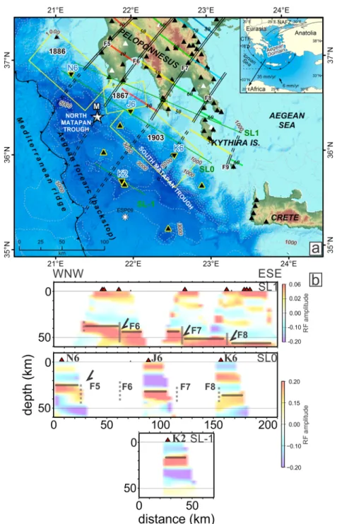
Figure 1. Map of the SW Hellenic subduction region and RF imaging of deep seismic structure. (a) Black triangles: the onshore-offshore (with yellow outline) seismological stations of TWR project. White triangles: Permanent stations of NOA (National Observatory of Athens) network. Reversed black triangles: locations of the four additional OBS with Guralp CMG40 T seismometers used for the RF study. Asterisk: location of ESP 9. Yellow rectangular areas: The presumed rupture areas of the M ~ 8.0 [Wyss and Baer, 1981] large events of 1886, 1867 and 1903 reevaluated to ~7 [Papadopoulos, 2011]. Star (M): epicenter location of the 2008 Methoni earthquake (by this study) off Peloponnesus. Double-lines: Slab along-dip faults from Sachpazi et al. [2016]. Dashed double lines: offshore fault prolongation to the SW (this study). Colored lines: isobaths of slab Moho with depth in kilometers. Black barbed line offshore: local thrust contact of the accretionary wedge of the Mediterranean Ridge over the Hellenic forearc backstop. Bathymetry from Brosolo et al. [2012]. Inset: Sketch of the Hellenic subduction zone in the wider context, with GPS velocity vector for the Aegean plate relative to a Eurasia reference frame [Kahle et al., 2000]. (b) Along-strike RF sections, SL1 (top) from Sachpazi et al. [2016], SL0 (middle), and SL-1 (bottom), from OBS of the present study (locations on Figure 1a) showing the panels of the dipping Hellenic slab. Solid grey line: middle of slab crust above red colored Moho slab (slab top and Moho being 3–4 km below and above, respectively [Gesret et al., 2010]. A more detailed discussion of the methodology can be found in the supporting information [Gesret et al., 2011; Langston, 1977; Niu et al., 2007].
In the Hellenic subduction zone at variance to other well-studied subduction systems, there have been no megathrust earthquakes in the recent era of high-quality instrumental seismological recording to allow reliable location and estimate of the seismogenic portion of the interplate boundary. The latter can neither be obtained by the offshore background seismic activity. Hypocenter locations are not sufficiently con-strained, because of both lack of proximal stations and poor azimuthal coverage, since all permanent stations are on land. These data thus cannot provide insight on the seismogenic patterns of the interplate thrust boundary owing to difficulties in determining accurately their hypocenter locations and focal depths. This can only be improved by the use of OBSs (ocean bottom seismometers), which provide obser-vations close to the hypocenters.
Here we present an integrated approach of the seismic structure and activity in the offshore region along the SW Hellenic forearc between western Peloponnesus and Crete. The onshore RF imaging [Sachpazi et al., 2016] is extended at four OBSs to resolve the depth and the geometry of the slab top offshore. We study the Mw6.8
14 February 2008 Methoni interplate earthquake off Peloponnesus, the largest interplate thrust earthquake for over half a century, along the 400 km long part of the Hellenic subduction. The precise location obtained for the main shock and its aftershocks as well as of the preceeding local seismicity form a critical test of the specific features of the slab top topography we obtained independently. Conversely, we discuss its location and rupture patterns in respect not only to this specific offshore slab top segmentation but also to the upper plate sea-bottom morphology. The latter, resolved exceptionally well by new bathymetric mapping, could be also discussed with respect to offshore local seismic activity constrained by ocean bottom seismometer (OBS) observations.
2. Experiment and Data
Through the European Union“THALES WAS RIGHT” project (TWR) launched to study the European subduction zones seismic structure and activity, a set of 20 three-component seismometers were operating (2006–2009) in southern Peloponnesus and nearby islands, as part of a larger survey across southwest Greece. This close-by array, recording for over 3 years included the 14 February 2008 Mw6.8 Methoni earthquake (Figure 1a). The land array had been complemented 18 months before this major event byfive three-component OBSs along the South Matapan Trough (Figure 1a) for 5 months (Text S1 in the supporting information). The offshore seismic activity has been located here with data obtained by these OBS, in addition to the onshore TWR stations and National Observatory of Athens (NOA) permanent network (Figure 1a). About 260 events were observed at a minimum number of four stations (including at least one OBS). A subset of 160 events having an azimuthal gap of less than 200° represents the best constrained hypocenters with an average of 13 observations per event (Text S1 in the supporting information). Furthermore, we achieved to recover usable teleseismic waveforms with four intermediate-period OBSs in deep water to perform RF analysis (Text S2).
3. Results
3.1. Trenchward Continuation of Along-Dip Faults Segmenting the Slab Top
Three of the OBSs (N6, J6, and K6) were deployed parallel to and northeast of the Matapan Trough between SW offshore Peloponnesus and SW of Kythira island (Figure 1a). The forth OBS (K2) was deployed SW of the Matapan Trough, 40 km north of the position of the ESP 9. We display them on RF vertical depth sections, approximately orientated in the slab along-strike direction (WNW-ESE) (bottom and middle of Figure 1b). A clear positive marker, which can be tentatively interpreted as the lower plate Moho, is obtained from each OBS (Figure 1b and Text S2). The slab Moho beneath OBSK2 is observed at 22 km depth (bottom of Figure 1b), like the depth derived from ESP 9 by Jones et al. [2002]. The other three OBSs show a slab Moho at 27 km (N6), 35 km (J6) and 40 km (K6) respectively (Figure 1b middle). Despite the along-strike align-ment of N6 and J6, for which we would expect a constant slab Moho depth and the more updip position of K6, the Moho gets deeper from N6 (in the NW) to K6 (in the SE). The 7 km high downstepping between N6 and J6 is consistent with the vertical throw across the offshore prolongation of the faults F5 and F6. Similarly, the 5 km high downstepping of the Moho depth between OBS J6 and K6 is consistent with the ver-tical throw across the prolongation of the faults F7 and F8. These additional constraints for the lower plate Moho depth allow to extrapolate farther updip the initial contouring of the slab Moho topography, as well as that of its top, considering a slab crust thickness of 7–8 km [Gesret et al., 2010] (Figure 2). The OBS were
deployed at relatively short distances, 25–30 km, from the coast of Peloponnesus, below which the faults have been reliably located. Thus, each of these faults can be reasonably prolonged offshore, toward SW, up to the location of the OBSs, by considering a strike similar to that observed below the Peloponnesus. New high-resolution morphobathymetric maps [Brosolo et al., 2012] may provide further observational evidence on the structural impact of the along-dip slab top faults activation already as far offshore as the backstop’s edge with the Mediterranean Ridge. We may remark in Figure 1a that the contact of the MR accretionary wedge against the continental backstop offshore SW Peloponnesus and West Crete is not a con-tinuous linear feature as usually shown but displays a zigzag pattern. The latter has already been documented by seafloor backscatter mapping [Huguen et al., 2006]. Here we identify 30 to 50 km long NW-SE trending segments (Figure 2, in red) that are disrupted by smaller NE-SW ones. Thus, the backstop not only gets progressively away from the continental margin from SW Peloponnesus to the southwest of western Crete [Le Pichon et al., 2002] but also displays a step-like geometry in map. The offshore prolongation of the N30°–40° trending slab faults (F5–F7) may provide an explanation for the disrupted backstop into several corresponding segments and their dextral shifting. The along-strike segmentation brings the slab panels suc-cessively deeper from NW to SE when crossing the individual slab faults. A corresponding deformation is
Figure 2. Seismic activity beneath the Aegean offshore forearc domain. NMT and SMT are for North and South Matapan Troughs, respectively. Map view of earthquakes located by the TWR onshore-offshore network and permanent national stations during 5 months in 2006. Circles: epicenter locations of earthquakes scaled by their magnitude. Colored: depth-coded locations of earthquakes with azimuthal gap< 200°. Grey: with larger gap. Star denotes the epicenter of 2008 Methoni interplate earthquake, located by this study at 15 km depth. Assuming that this is the depth of the top of the subducting slab, we placed a slab Moho contour 8 km deeper. Additional slab contours are obtained from RF imaging (Figure 1b) and from refraction imaging (ESP 9). Colored lines: isobaths of slab Moho and top (in brackets) with depth in kilometers. Black barbed line offshore: contact between the accretionary wedge of the Mediterranean Ridge and the Hellenic forearc backstop. The NW-SE segments of the contact are superposed by red color. Inset: Comparison between the epicenters located by both land (TWR/NOA) and OBS data (black dots) with those of NOA data only (white dots). Grey small dots represent NOA epicenters outside the studied area.
induced onto the overriding upper plate, leading here, in the outer forearc, to the differential advance of the tip of the Aegean backstop. The latter accounts for the backstep from each panel to the next to the SW of the thrust contact of the Mediterranean Ridge accretionary wedge over the upper plate.
Our new observations in the outer forearc show clearly a strong relationship between the offshore slab topo-graphy and Aegean mobility and deformation and support the results of Sachpazi et al. [2016].
3.2. Earthquake Distribution of the 5 Month Long OBS and Land Array Recording in 2006
Constraints from the close-by OBSs observations and additional coastal land stations data reveal thefirst accurate image of current hypocenters offshore southwestern Peloponnesus. Comparisons of our locations with those of the permanent on-land network (NOA catalogue) reveal errors in location by up to several tens of kilometers for the South Peloponnesus-Crete segment (Figures 2 inset and S1). The density of the per-manent stations was rather poor in this region located between the southwestern Aegean Sea and the Ionian Sea. The use of an OBS network offshore southern Peloponnesus and Western Crete (between longitudes of 23° and 24°), even with only few instruments, allows us to relocate hypocenters initially located in the Aegean Sea, at 100 km further southwest in the South Matapan Trough. For the southwestern Peloponnesus (between longitudes of 21.5° and 22.5°), mislocation by the permanent array on land is less dramatic but may reach a value of 50 km for some events. This is in accordance to our experience during an OBS deploy-ment in the Lesser Antilles subduction zone [Laigle et al., 2013]. A second main result is that hypocenters of the 5 months period seismic activity, along the 250 km long segment of the southwest Hellenic subduction zone are mostly located at 10–15 km depths, in the upper plate’s crust (Figures 2 and S1). A third main result is the segmentation of the hypocenters distribution both along dip and along strike the slab. In the along-dip direction, most of the well-resolved current seismicity is concentrated beneath the South Matapan Trough region, at distances from the edge of the backstop ranging between 50 and 100 km. This seismicity, trending NW-SE may even be further resolved into two parallel bands (between longitude of 22° and 23°). Afirst band with earthquakes is located just along the northeastern edge of the South Matapan Trough and (along) the narrower depression that extends the south Matapan trough, northwestward, toward the North Matapan trough. A second band with more earthquakes is located about 25 km further SW along the other side of the South Matapan Trough. In the along-strike direction, this seismic activity is observed up to the western coast of Crete Island, but to the NW, in the northwestern part of the slab panel F6–F7, it becomes more sparse, with no events in the vicinity of the F6 slab fault and in the F5–F6 slab panel. It is within this transition zone that the Mw6.8 Methoni 2008flat-thrust interplate earthquake occurred.
Thefirst well-constrained local seismic activity offshore SW Peloponnesus, recorded for a period of 5 months, is shown to correlate thus clearly with an Aegean fore-arc specific feature, beneath the south Matapan Trough which has not previously been considered as a seismically active region.
3.3. Location of the 2008 Methoni Sequence by TWR Onshore Network
On 14 February 2008, an earthquake with moment magnitude Mw6.8 occurred about 50 km offshore the
westernmost peninsula of Peloponnesus (Figure 1a). This was the largest interplate thrust event for half a century in the 400 km long part of the Hellenic subduction, from the Ionian Islands to Crete. Focal mechanism determinations of all agencies show a typical subductionflat thrust on a N35°E dipping plane (Figure 3). However, their hypocenter’s locations, based mainly on distant observations, are spreading over a distance larger than 40 km both horizontally and vertically (Figure S2) preventing any discussion with respect to the location of the seismogenic interplate boundary. This event was recorded by our TWR close-by land stations in addition to those of the permanent Hellenic network and hence could be located using nearby P and S arri-vals. Its depth is resolved to 15 km (Figure S1). Its hypocenter is located on the offshore prolongation of the along-dip slab top fault F6 (M in Figure 3). As shown from teleseismic and regional broad band waveform modeling [Roumelioti et al., 2009] the rupture did not propagate NW of the hypocenter and the coseismic slip was totally distributed unilaterally to the SE (Figure 3).
Two hours after the main shock, a major aftershock (Mw6.5) occurred with a focal mechanism and depth simi-lar to the main event (Figures 3 and S2). Its hypocenter is located 25 km southeast of the main event, at the southeastern border of the coseismic slip area. At the end of that week, another large event (Mw6.2) occurred,
but at only 9 km depth, right above the major interplate aftershock (Figures 3, yellow circle, and S2). Its cen-troid moment tensor (CMT) Harvard mechanism shows a pure strike-slip movement, with a roughly NE-SW
horizontal compressive principal axis. Another 10 significant earthquakes (Mwbetween 4.6 and 5.4) occurred
over the next 3–4 months at shallower depths (5–9 km), on steeper reverse faults, also with a NE-SW horizon-tal compressive principal axis (Figure 3). They are located between the southeastern edge of the main shock rupture zone and the slab fault F7.
3.4. Structural Segmentation Controls the Interplate Slip and Upper Plate Motion and Deformation
We show here that the along-dip faults imaged beneath the SW Peloponnesus coast may continue much farther seaward, under the offshore portion of the Aegean plate forearc to segment the subduction interplate boundary. It is on the offshore prolongation of the slab fault F6 that the Mw6.8 Methoni interplate earthquake occurred. Its rupture patterns may be discussed here in respect to the structural segmentation.
The main shock ruptured the interplate fault allowing the southwestward overriding motion of the Aegean upper plate. The rupture propagated from northwest to southeast over a distance of 30 km across the slab panel F6–F7, but the remaining southeastern part of the slab panel (~20 km) shows no coseismic slip on the interplate during the main shock. The area of the panel F6–F7 ruptured again 2 hours after the main shock with an earthquake of Mw6.5 (Figure 3), an uncommonly large magnitude event compared to a regular main
shock-aftershock sequence. Its hypocenter is located right at the SE border of the main shock rupture. Even though the slip distribution for its source is not known, we may reasonably assume that it continued the inter-plate slip to the SE. Given its magnitude [Wells and Coppersmith, 1994], it may correspond to a rupture pro-pagation along the remaining 20 km long south eastern part of the slab panel F6–F7. In contrast to the main shock slip area, this part of the panel is characterized by significant postseismic activity which occurs above the interplate fault, within the forearc crust.
Figure 3. Same bathymetric map as in previousfigures with different color scale. MM for Mounts Matapan [Le Quellec and Mascle, 1979]. Comparison of the coseismic slip distribution area of the Mw6.8 Methoni earthquake with the distribution of the hypocenters of the main shock and stronger aftershocks (with Mwby CMT Harvard) located by the densified onshore TWR network. Stars for the main shock (M) and major interplate aftershock and yellow circle for the major shallow aftershock. With dark red: main shock (M) and major interplate aftershock CMT (Harvard) focal mechanisms. Light red: same for the shallow aftershocks placed in the position of the epicenters, respectively.
A difference in behavior between these two parts of the slab panel F6–F7 may be also observed in the pre-Methoni local seismic activity (Figure 2). Indeed in the northwest part of the panel F6–F7 almost no microseismicity occurs whereas in the adjacent southeastern part there is some activity. The relative quiescence in the pre-Methoni seismicity may reflect the interseismic locking of the interplate fault of the slab segment F6–F7 and strong coupling of the two plates [Schwartz and DeShon, 2007] at its northwest part, in variance with a relatively lower coupling for the southeast part. It is on the rather silent part that the main shock initiated and its coseismic slip distributed. It has not been followed by significant aftershocks contrast-ing with the southeastern adjacent part where the slip of the Mw6.5 event probably extended but where
strong aftershocks spread.
We suggest that the Mw6.8 main shock succeeded triggering an earthquake as large as 6.5, because this was
hence completing the slip of the whole width of the specific F6–F7 interplate panel. Both rupture dimensions and slip amplitude of the second earthquake are more modest scaled by its lesser magnitude [Wells and Coppersmith, 1994]. This may, jointly with the characteristics of the preseismic and postseismic activity, indicate less coupling for the southeastern part of the panel in contrast to its northwestern one.
The seafloor relief topography compiled and published with an unprecedented high resolution by Brosolo et al. [2012] shows clearly the limits of the main depressions of the Matapan Troughs and the presence of a local northwest-southeast topographic high designated as the Mounts of Matapan [Le Quellec and Mascle, 1979]. Being between the North and South Matapan Troughs this sea-bottom relief has been regarded as marking a disorganization of the Matapan trench [Mascle and Le Quellec, 1980]. This high is 10 km wide and extends for about 70 km from the deep edge of the North Matapan Trough above F6, over the F6–F7 panel, and into the next one to the SE. It is flanked to the northeast, by a 10–20 km wide, long depression which continues to the NW the main wider South Matapan Trough and to the southwest by the continuation of the North Matapan Trough. Interestingly, the 25–30 km along-dip slip distribution of the Mw6.8 event shows that main slip amplitude remains at the SW updip edge, mainly under the
southflank of the Matapan mounts with lesser slip at the NE downdip edge. Unfortunately, no deep seis-mic profiles data have been published yet; hence, it is difficult to interpret the bathymetric data with respect to possible subsurface structure. However, the significant shallow reverse earthquakes right beneath the twoflanks of the Matapan Mounts are consistent with upper plate crust deformation. It is thus possible that this bathymetric feature has a deeper significance playing an important role on the megathrust coupling.
Our new constraints on deep seismic activity and structure show here the influence of the detailed morphol-ogy of a slab on seismogenesis and seismic hazard as well as on subduction zone dynamics.
4. Conclusions
The results of our integrated study of seismic structure and activity along the SW Hellenic forearc from tem-porary arrays of seismometers on land and ocean bottom seismometers (OBS) document a southwestward prolongation of the along-dip slab top faults we previously discovered under the Peloponnesus [Sachpazi et al., 2016]. Continuations of the slab top faults much farther trenchward, under the Aegean forearc, 100–200 km offshore SW Peloponnesus, can provide by their spacing and location a structural frame to resolved indentations at sea bottom of the contact of the Mediterranean Ridge accretionary material on the backstop.
We show that local seismic activity during the 5 month period of the offshore/onshore monitoring is localized in relation with a specific feature of the Aegean upper plate backstop, the Matapan Troughs. It is under the South Matapan Trough’s northern and southern edges and above the interplate that the local seismic activity appears located. We could record—18 months later by the densified onshore land stations—the Mw6.8 Methoni of 14 February 2008, which was the largest interplate earthquake in the half
century andfirst instrumentally monitored major event at this part of the subduction. Our study of the main shock and its sequence shows that both upper plate activity and interplate slip remain confined to the slab panel F6–F7 between the two adjacent offshore prolongated along-dip faults and are thus con-trolled by the segmentation in the top of the subducting plate. Our observations allow discussion between the characteristics of interplate slip and upper plate motion and deformation in relation to highly resolved bathymetric features.
References
Brosolo, L., J. Mascle, and B. Loubtrieu (2012), MorphoBathymetry of the Mediterranean Sea, Map 1/4.000.000, 1st ed., Comm. for the Geol. Map of the World (CGMW) and UNESCO, Paris.
Chamot-Rooke, N., A. Rabaute, and C. Kreemer (2005), Western Mediterranean Ridge mud belt correlates with active shear strain at the prism-backstop geological contact, Geology, 33, 861–864, doi:10.1130/G21469.1.
De Voogd, B., C. Truffert, N. Chamot-Rooke, P. Huchon, S. Lallemant, and X. Le Pichon (1992), Two-ship seismic soundings in the basins of the Eastern Mediterranean Sea (Pasiphae cruise), Geophys. J. Int., 109, 536–552.
England, P., A. Howell, J. Jackson, and C. Synolakis (2015), Palaeotsunamis and tsunami hazards in the Eastern Mediterranean, Phil. Trans. R. Soc. A, 373, 20140374, doi:10.1098/rsta.2014.0374.
Gesret, A., M. Laigle, J. Diaz, M. Sachpazi, and A. Hirn (2010), The oceanic nature of the African slab subducted under Peloponnesus: Thin-layer resolution from multiscale analysis of teleseismic P to S converted waves, Geophys. J. Int., 183, 833–849, doi:10.1111/ j.1365-246X.2010.04738.x.
Gesret, A., M. Laigle, J. Diaz, M. Sachpazi, M. Charalampakis, and A. Hirn (2011), Slab top dips resolved by teleseismic converted waves in the Hellenic subduction zone, Geophys. Res. Lett., 38, L20304, doi:10.1029/2011GL048996.
Huguen, C., N. Chamot-Rooke, B. Loubrieu, and J. Mascle (2006), Morphology of a pre-collisional, salt-bearing, accretionary complex: The Mediterranean Ridge (Eastern Mediterranean), Mar. Geophys. Res., 27, 61–75, doi:10.1007/s11001-005-5026-5.
Jones, K. A., M. Warner, D. Le Meur, G. Pascal, P. L. Tay, and IMERSE working group (2002), Wide angle images of the Mediterranean Ridge backstop structure, Mar. Geol., 186, 145–166.
Jongsma, D. (1977), Bathymetry and shallow structure of the Pliny and Strabo Trenches south of the Hellenic Arc, Geol. Soc. Am. Bull., 88, 797–805.
Kahle, H. G., M. Cocard, Y. Peter, A. Geiger, R. Reilinger, A. Barka, and G. Veis (2000), GPS-derived strain ratefield within the boundary zones of the Eurasian, African, and Arabian plates, J. Geophys. Res., 105, 23,353–23,370, doi:10.1029/2000JB900238.
Laigle, M., et al. (2013), Seismic structure and activity of the north-central Lesser Antilles subduction zone from an integrated approach: Similarities with the Tohoku forearc, Tectonophysics, 603, 1–20, doi:10.1016/j.tecto.2013.05.043.
Lallemant, S., C. Trufert, L. Jolivet, P. Henry, N. Chamot- Rooke, and B. de Voogd (1994), Spatial transition from compression to extension in the Western Mediterranean Ridge accretionary complex, Tectonophysics, 234, 33–52.
Langston, C. A. (1977), Corvallis, Oregon, crustal and upper mantle structure from teleseismic P and S waves, Bull. Seismol. Soc. Am., 67, 713–724.
Le Pichon, X. S., J. Lallemant, N. Chamot-Rooke, D. Lemeur, and G. Pascal (2002), The Mediterranean Ridge backstop and the Hellenic nappes, Mar. Geol., 186, 111–125.
Le Quellec, P., and J. Mascle (1979), Hypothese sur l origine des monts Matapan (marge ionienne du Peloponnese): Academie des Sciences, Compte Rendus, 288, 31–34.
Mascle, J., and P. Le Quellec (1980), Matapan trench (Ionian Sea): Example of trench disorganization?, Geology, 8, 77–81.
Niu, F., T. Bravo, G. Pavlis, F. Vernon, H. Rendon, M. Bezada, and A. Levander (2007), Receiver function study of the crustal structure of the southeastern Carribean plate boundary and Venezuela, J. Geophys. Res., 112, B11308, doi:10.1029/2006JB004802.
Papadopoulos, G. A. (2011), A Seismic History of Crete: The Hellenic Arc and Trench, Earthquake and Tsunamis 2000 BC–2011 AD, Ocelotos Publ. Sci., Athens.
Papadopoulos, G. A., I. Baskoutas, and A. Fokaefs (2014), Historical seismicity of the Kyparissiakos Gulf, western Peloponnese Greece, B. Geofis. Teor. Appl., 55, 389–404.
Papazachos, B. C., and K. Papazachou (2003), The Earthquakes of Greece, 286 pp., Ziti Publ., Thessaloniki.
Roumelioti, Z., C. Benetatos, and A. Kiratzi (2009), The 14 February 2008 earthquake (M6.7) sequence offshore south Peloponnese (Greece): Source models of the three strongest events, Tectonophysics, 471, 272–284, doi:10.1016/j.tecto.2009.02.028.
Sachpazi, M., M. Laigle, M. Charalampakis, J. Diaz, E. Kissling, A. Gesret, A. Becel, E. Flueh, P. Miles, and A. Hirn (2016), Segmented Hellenic slab rollback driving Aegean deformation and seismicity, Geophys. Res. Lett., 43, 651–658, doi:10.1002/2015GL066818.
Schwartz, S. Y., and H. R. DeShon (2007), Distinct updip limits to geodetic locking and microseismicity at the northern Costa Rica seismogenic zone: Evidence for two mechanical transitions, in The Seismogenic Zone of Subduction Thrust Faults, edited by T. H. Dixon and J. C. Moore, pp. 576–599, Columbia Univ. Press, New York.
Shaw, B., and J. Jackson (2010), Earthquake mechanisms and active tectonics of the Hellenic subduction zone, Geophys. J. Int., 181, 966–984, doi:10.1111/j.1365-246X.2010.04551.x.
Truffert, C., N. Chamot-Rooke, S. Lallemant, B. de Voogd, P. Huchon, and X. Le Pichon (1993), The crust of the Western Mediterranean Ridge from deep seismic data and gravity modeling, Geophys. J. Int., 114, 360–372.
Wells, L. D., and J. K. Coppersmith (1994), New empirical relationships among magnitude, rupture length, rupture width, rupture area and surface displacement, Bull. Seismol. Soc. Am., 84, 974–1002.
Wyss, M., and M. Baer (1981), Earthquake hazard in the Hellenic arc, in Earthquake Prediction: An International Review, vol. 4, edited by D. W. Simpson and P. G. Richards, pp. 153–172, AGU, Washington, D. C.
Geophysical Research Letters
10.1002/2016GL070447
Acknowledgments
This research has been supported by the European Union FP6 NEST_INSIGHT programme, under project THALES WAS RIGHT. We thank the National Observatory of Athens, NOA, for pro-viding data from permanent seismolo-gical stations. We thank Rinaldo Nicolich from University of Trieste for providing information on the marine part. We thank D.J.J. van Hinsbergen, an anonymous reviewer, and the Editor for critical evaluation.
![Figure 3. Same bathymetric map as in previous fi gures with different color scale. MM for Mounts Matapan [Le Quellec and Mascle, 1979]](https://thumb-eu.123doks.com/thumbv2/123doknet/12936922.374635/7.918.303.819.132.606/figure-bathymetric-previous-different-mounts-matapan-quellec-mascle.webp)
