HAL Id: insu-01312746
https://hal-insu.archives-ouvertes.fr/insu-01312746
Submitted on 29 Jun 2016
HAL is a multi-disciplinary open access
archive for the deposit and dissemination of
sci-entific research documents, whether they are
pub-lished or not. The documents may come from
teaching and research institutions in France or
abroad, or from public or private research centers.
L’archive ouverte pluridisciplinaire HAL, est
destinée au dépôt et à la diffusion de documents
scientifiques de niveau recherche, publiés ou non,
émanant des établissements d’enseignement et de
recherche français ou étrangers, des laboratoires
publics ou privés.
basin: an example from the south Pyrenean thrust belt
Pierre Labaume, Florian Meresse, Marc Jolivet, Antonio Teixell, Abdeltif
Lahfid
To cite this version:
Pierre Labaume, Florian Meresse, Marc Jolivet, Antonio Teixell, Abdeltif Lahfid. Tectono-thermal
history of an exhumed thrust-sheet-top basin: an example from the south Pyrenean thrust belt.
Tectonics, American Geophysical Union (AGU), 2016, 35 (5), pp.1280-1313 �10.1002/2016TC004192�.
�insu-01312746�
Tectonothermal history of an exhumed thrust-sheet-top
basin: An example from the south Pyrenean thrust belt
Pierre Labaume1, Florian Meresse1,2, Marc Jolivet1,3, Antonio Teixell4, and Abdeltif Lahfid5
1
Laboratoire Géosciences Montpellier, Université de Montpellier, INSU-CNRS, Montpellier, France,2Now at Centre Scientifique et Technique Jean-Féger, Total, Pau, France,3Laboratoire Géosciences Rennes, Université de Rennes 1,
INSU-CNRS, Rennes, France,4Departament de Geologia, Universitat Autònoma de Barcelona, Bellaterra, Spain,5BRGM, Orléans, France
Abstract
This paper presents a new balanced structural cross section of the Jaca thrust-sheet-top basin of the southern Pyrenees combined with paleothermometry and apatitefission track (AFT) thermochronology data. The cross section, based onfield data and interpretation of industrial seismic reflection profiles, allows refinement of previous interpretations of the south directed thrust system, involving the identification of new thrust faults, and of the kinematic relationships between basement and cover thrusts from the middle Eocene to the early Miocene. AFT analysis shows a southward decrease in the level offission track resetting, from totally reset Paleozoic rocks and lower Eocene turbidites (indicative of heating to Tmax> ~120°C), to partially reset middle Eocene turbidites and no/very weak resetting in the upper Eocene-lower Oligocene molasse (Tmax< ~60°C). AFT results indicate a late Oligocene-early Miocene cooling event throughout the Axial Zone and Jaca Basin. Paleomaximum temperatures determined by vitrinite reflectance measurements and Raman spectroscopy of carbonaceous material reach up to ~240°C at the base of the turbidite succession. Inverse modeling of AFT and vitrinite reflectance data with the QTQt software for key samples show compatibility between vitrinite-derived Tmaxand the AFT reset level for most of the samples. However, they also suggest that the highest temperatures determined in the lowermost turbidites correspond to a thermal anomaly rather than burial heating, possibly due tofluid circulation during thrust activity. From these results, we propose a new sequential restoration of the south Pyrenean thrust system propagation and related basin evolution.1. Introduction
The growth of orogenic fronts implies strong interactions between thrust displacement and propagation, vertical movements, and sediment transfer that contribute to maintaining the taper of the wedge [e.g., Davis et al., 1983; Dahlen, 1990]. These interactions also determine burial/exhumation processes and hence the thermal evolution both in the orogenic belt and in its foreland basin. Quantifying these processes is thus crucial to understand the evolution of orogens, but this may be a difficult task when several detachment levels are involved in a complex wedge structure or when the thermal evolution is affected byfluid migration. Given the exceptional preservation of synorogenic sedimentary sequences, the south Pyrenean basin is well suited for studying the relationships between thrusting and foreland and thrust-sheet-top basin evolution. However, certain aspects of the kinematic links between the basement thrusts forming the Axial Zone of the Pyrenees and the cover structures emerging in the basin remain debated due to insuf fi-cient knowledge of the deep structure of the basin and of the timing of the basement thrust sequence. These uncertainties also affect the understanding of the thermal history of the basinfill in terms of burial, exhumation, and fluid migration. Most of the previous medium- to low-temperature thermochronology studies (40Ar/39Ar, zircon and apatitefission tracks, and (U-Th)/He)) in the south Pyrenean thrust system concentrate on the Paleozoic basement rocks of the Axial Zone [Morris et al., 1998; Fitzgerald et al., 1999; Sinclair et al., 2005; Gibson et al., 2007; Jolivet et al., 2007; Maurel et al., 2008; Metcalf et al., 2009; Bosch et al., 2016]. Comparatively, few studies have been carried out in the Cenozoic south Pyrenean basin, with a limited number of samples which were mostly concentrated along the northern margin of the basin [Beamud et al., 2010; Filleaudeau et al., 2012; Rahl et al., 2011; Whitchurch et al., 2011; Fillon et al., 2013; Rushlow et al., 2013]. Furthermore, most of these studies are localized in the east central Pyrenees where, due to limited sediment burial, apatitefission tracks are generally weakly or not reset within the basin, and thus, they mostly reflect the exhumation history of the source areas rather than the thermal evolution of the basinfill.
Tectonics
RESEARCH ARTICLE
10.1002/2016TC004192 Key Points: • Approximately 41 km (~47%) of shortening across the eastern Jaca Basin of the S. Pyrenees from the middle Eocene to early Miocene • Variable degrees of thermal resettingwith late Oligocene to early Miocene exhumation revealed by apatite fission track analysis
• Localized, transient thermal anomaly (transient hotfluid migration?)
Correspondence to:
P. Labaume,
Citation:
Labaume, P., F. Meresse, M. Jolivet, A. Teixell, and A. Lahfid (2016), Tectonothermal history of an exhumed thrust-sheet-top basin: An example from the south Pyrenean thrust belt, Tectonics, 35, 1280–1313, doi:10.1002/ 2016TC004192.
Received 24 MAR 2016 Accepted 3 MAY 2016
Accepted article online 6 MAY 2016 Published online 28 MAY 2016
©2016. American Geophysical Union. All Rights Reserved.
In this work, we combine detailed structural and thermochronological studies along a profile of the eastern Jaca thrust-sheet-top basin, from the southern part of the Axial Zone to the south Pyrenean thrust front. A cumulative thickness of up to 10 km of synorogenic sediments and a similar order of structural relief due to basement thrusting make this part of the southern Pyrenees suitable for analyzing the links between the activity of the Pyrenean thrust system and the kilometric scale vertical movements of burial and exhuma-tion of the basin. Interpretaexhuma-tion of industrial seismic reflection profiles provides the basis for the construction of a new balanced cross section constraining the geometry of the basement thrust system and its connec-tions with the cover structures through the Triassic detachment level. The thermal history is investigated with apatitefission track analysis on 25 samples distributed along the whole section, including 18 samples in the basinfill providing the most complete thermochronological study to date across the south Pyrenean basin. Maximum paleotemperatures were also determined for some samples using vitrinite reflectance measure-ments and Raman spectroscopy of carbonaceous material. Inverse modeling of AFT and vitrinite reflectance data with the QTQt software [Gallagher, 2012] was made on key samples to test the compatibility between vitrinite-derived temperatures and AFT reset level. These data are integrated in a step-by-step restoration of the Jaca Basin deformation defining a new interpretation of the thrust propagation sequence, the distribution of shortening and displacement transfer, and the burial/exhumation history of foreland basin deposits that were incorporated in the thrust wedge as the Pyrenean orogen grew outward. We also show that the paleothermal record was affected by the occurrence of transient anomalies possibly related to hot fluid migration.
2. Geological Setting
2.1. The Pyrenean BeltThe Pyrenean belt is a doubly vergent collisional orogen formed from the Late Cretaceous to the early Miocene in relation to the northward subduction of the Iberian plate under the European plate [Roure et al., 1989; Muñoz, 1992; Vergés et al., 2002; Teixell, 1998; Beaumont et al., 2000; Mouthereau et al., 2014; Teixell et al., 2016]. On the southern side of the belt, the south vergent thrust system (prowedge) comprises imbricated thrust units of Iberian Paleozoic basement which form the Axial Zone, connected to the south to detached thrust units of Mesozoic and Tertiary cover, which form the South Pyrenean Zone (Figure 1). The latter comprises synorogenic thrust-sheet-top basins of Paleogene age, partitioned in several subbasins by oblique thrust ramps splaying from a Triassic detachment level. To the south, the South Pyrenean Zone overrides the Ebro foreland basin. On the northern side of the belt, the North Pyrenean Zone (retro wedge) comprises a system of Mesozoic extensional basins inverted by the Pyrenean compression and thrust both southward above the Axial Zone and northward onto the Aquitaine foreland basin [Roure et al., 1989;
Figure 1. Structural sketch map of the Pyrenean orogen (simplified after Teixell [1996]). Box: study area (shown in Figure 2). Ba, Boltaña anticline; PMth, Peña Montañesa thrust; Sp, Somport pass; 1, Paleozoic rock units; 2, Mesozoic strata; 3, Cenozoic strata in thrust-sheet-top basins; and 4, Cenozoic strata in foreland (and Mediterranean) basins.
Figure 2. Detailed geological map of the study area in the eastern Jaca Basin (location in Figure 1). Data compiled from published maps [Puigdefábregas Tomás, 1975; Gil Peña et al., 1990; Rios Aragües et al., 1990; Montes Santiago, 1991; Ternet et al., 2003; Millán Garrido, 2006], completed with additional ownfield studies. Black dots: thermometry and apatite fission track samples (samples JA2 and JA3 are located west of the map in the Somport pass area, labeled Sp in Figure 1); white dots: nondatable samples, with thermometry results only; black circles in the Bielsa and Néouvielle granites: apatitefission track samples from Jolivet et al. [2007] cited in the text; black lines: seismic reflection profiles in Figure 6; derrick symbols: drill holes; red line: cross section in Figure 5. UMPT: Upper Monte Perdido thrusts; CMK: Castillo Mayor klippe; CTS: Cotiella thrust sheet. Inset legend: 1: pre-Permian (Hercynian) basement, including Hercynian granites (a; mostly migmatites in the Gavarnie window); 2: undifferentiated Permo-Triassic stratigraphic units (Bielsa massif) or Triassic Muchelkalk and Keuper (Sierras Exteriores); 3: platform carbonates and sandstones; 4: terrestrial red beds (Garumnian facies); 5: platform carbonates; 6: Hecho Group turbidites (MT3 to 5: carbonate breccia megabeds numbered according to Labaume et al. [1985]); 7: Larrés marl; 8: Sabiñánigo sandstone (delta); 9: Guara and Boltaña platform limestones; 10: Arguis-Pamplona marl; 11: Belsué-Atarés sandstone (deltaic); 12: Campodarbe Group (fluvial-alluvial); and 13: Uncastillo Formation (alluvial-fluvial).
Muñoz, 1992; Vergés et al., 2002; Teixell, 1998; Beaumont et al., 2000; Mouthereau et al., 2014; Teixell et al., 2016; Jammes et al., 2009; Lagabrielle et al., 2010].
Shortening across the belt remains debated. From balanced sections it has been estimated between 100 km [Roure et al., 1989] and 165 km [Beaumont et al., 2000] in the east central Pyrenees and to 80 km in the west central Pyrenees [Teixell, 1998]. The most recent estimations converge between 90 and 100 km of crustal shortening [Mouthereau et al., 2014; Teixell et al., 2016], mainly accommodated by the prowedge (south direc-ted;≥70% of the total shortening). To these values, there should be added the closure of a domain of exhumed mantle of uncertain width, most probably a few tens of kilometers [Mouthereau et al., 2014; Teixell et al., 2016].
2.2. The Study Area
The study area corresponds to a N-S transect across the eastern part of the south Pyrenean Jaca thrust-sheet-top basin and adjacent southern part of the Axial Zone (Figures 1 and 2). The Jaca Basin forms a vast E-W trending synclinorium characterized by Eocene and Oligocene synorogenic sediments located between the southern edge of Axial Zone (the Sierras Interiores in Figure 2) and the emerging south Pyrenean frontal thrust (the Sierras Exteriores in Figure 2). A few additional sampling localities are located in the NW part of the Ainsa Basin for comparison (Figure 2).
2.2.1. Lithostratigraphic Organization
The chronostratigraphic diagram in Figure 3 summarizes the general lithostratigraphic organization of the eastern Jaca Basin along a N-S profile, whereas Figure 4 shows a new synthesis of the stratigraphic ages based on a compilation of previous biostratigraphic and magnetostratigraphic studies correlated with a recent geo-magnetic polarity time scale [Gradstein et al., 2012].
The basement comprises Paleozoic rocks deformed during the Hercynian orogeny and intruded by late Hercynian granitoids, locally overlain by a tegument of post-Hercynian Permian-Lower Triassic detrital sedi-ments [Barnolas and Chiron, 1996]. Middle-Upper Triassic shales, carbonates, and evaporites (Muschelkalk and Keuper facies) form the detachment level below most of the Jaca Basin (drilled in the Broto, Serrablo1 and San Vincente wells; Figure 2) and Sierras Exteriores; they disappear northward and are absent in the Axial Zone. The post-Triassic cover begins with Upper Cretaceous to lower Ypresian platform carbonates [e.g., Puigdefàbregas and Souquet, 1986]. The age of the basal transgression spans from the Cenomanian in
Figure 3. Chronostratigraphic diagram of the Jaca Basinfill along the north-south cross section shown in Figure 5 and localized in Figure 2 (red line). Time scale after Cohen et al. [2013]. AL: Alveolina limestone; BL: Boltaña limestone; GA: Garumnian terrestrial red beds; CG: Campodarbe Group (fluvial-alluvial); DF: deltaic facies (Larrés and Arguis-Pamplona marls and Belsué-Atarés sandstone); HG: Hecho Group turbidites; MS: Marboré sandstone; MT: carbonate breccia megabeds (numbered according to Labaume et al. [1985]); SS: Sabiñánigo sandstone (delta); UF: Uncastillo Formation (alluvial-fluvial).
the north to the Santonian in the south, and the carbonate succession thins southward, where its upper part shows a lateral change to terrestrial red beds.
In the northern part of the basin, the platform carbonates culminate with the lower Ypresian Alveolina lime-stone and are followed by the upper Ypresian to lower Bartonian turbidites of the Hecho Group, about 4000 m thick [e.g., Mutti et al., 1988; Remacha et al., 2003; Oms et al., 2003; Das Gupta and Pickering, 2008; Caja et al., 2009]. Much of the Hecho Group was fed axially from the east, but the uppermost turbidites show a northern provenance [Remacha et al., 1987, 1998; Roigé et al., 2016]. To the south, the turbidites onlap the coeval Boltaña and Guara platform limestones [Labaume et al., 1985; Puigdefàbregas and Souquet, 1986; Barnolas and Teixell, 1994; Mochales et al., 2012; Muñoz et al., 2013]. Several (three in the study area) thick carbonate breccia megabeds derived from the southern shelf are intercalated in the siliciclastic turbidites of the Hecho Group [Labaume et al., 1983, 1985, 1987; Barnolas and Teixell, 1994; Payros et al., 1999]. From middle Bartonian to early Priabonian times, the turbiditic basin was progressivelyfilled by westward prograding deltaic complexes (from bottom to top, the Larrés marl, the Sabiñánigo sandstone, the Arguis-Pamplona marl, and the Belsué-Atarés sandstone) [Puigdefábregas Tomás, 1975; Remacha et al., 1987; Hogan and Burbank, 1996; Dreyer et al., 1999]. Their accumulation was associated with a southward migration of the Jaca Basin depocenter with respect to the turbiditic stage, with a maximum thickness exceeding 2000 m in the central part of the basin [Teixell, 1996]. Above, the progradation of the terrestrial facies resulted in the deposition of the thick (~3500 m) Priabonian-Chattian Campodarbe Group, comprising east sourced fluvial deposits bordered to the north by north sourced alluvial fans [Puigdefábregas Tomás, 1975; Montes Santiago, 1992]. The Campodarbe Group is the youngest stratigraphic unit preserved in the Jaca Basin, where
Figure 4. Table presenting a synthesis of the ages of stratigraphic units and timing of activity of the major tectonic structures of the Jaca Basin and adjacent Axial Zone. Stratigraphic ages are compiled from previous magnetostratigraphic and biostratigraphic studies with absolute ages of chrons and stratigraphic divisions corrected according to recent timescales [Gradstein et al., 2012; Cohen et al., 2013]. Timing of cover structures (deduced from growth strata and angular unconformities) are compiled from previous studies and additional ownfield observations. Timing of basement thrusts are based of geometrical features and displacement transfer considerations as discussed in the text. References for stratigraphic units: Hogan and Burbank [1996]; Labaume et al. [1985]; Mochales et al. [2012]; Oliva-Urcia et al. [2015]; Oms et al. [2003]. References for cover structures: Hogan and Burbank [1996], Labaume et al. [1985], Poblet and Hardy [1995], Teixell [1996], Muñoz et al. [2013], and Oliva-Urcia et al. [2015]. AFT: apatitefission track ages in the Néouvielle [Jolivet et al., 2007] and Balaïtous (this work) granites; Ar-Ar:40Ar/39Ar ages of K-feldspar in shear zones in the Néouvielle granite [Jolivet et al., 2007] and authigenic illite from shear zones in the Gavarnie thrust fault zone [Rahl et al., 2011]; At: Atiart unconformity; Cd: Campodarbe unconformity; CL: Charro-Lascorz unconformity; PA: Pico del Aguila anticline; PS: Peña del Sol thrust; Rb/Sr: Rb-Sr ages of shear zones in the Néouvielle granite [Wayne and McCaig, 1998]; and SF: San Felices thrust. The Peña Montañesa thrust sheet (cf. cover structures) is located in the Ainsa Basin (Figure 1) and is represented on the map in Figure 2 by the Castillo Mayor klippe (CMK in Figure 2).
its top is dated close to the Rupelian-Chattian transition [Oliva-Urcia et al., 2015]. In the Ebro Basin, south of the thrust front, the top of the Campodarbe Group has been recently attributed to the late Chattian [Oliva-Urcia et al., 2015] and is followed by the alluvial-fluvial Uncastillo Formation of late Chattian to early Burdigalian age [Puigdefábregas Tomás, 1975; Arenas, 1993; Oliva-Urcia et al., 2015].
2.2.2. General Structure 2.2.2.1. Basement Thrusts
Previous works on the studied transect defined four main basement thrusts forming the south vergent Pyrenean thrust system. Two of them crop out in the Axial Zone: the Eaux-Chaudes thrust in the northern part and the Gavarnie thrust in the southern part (Figures 1 and 2). In the footwall of the Gavarnie thrust, two other basement thrusts have been inferred from the basement top culminations deduced from seismic reflection profiles and cross-section construction:
1. A basement thrust located below the northeastern Jaca Basin [Cámara and Klimowitz, 1985; Mutti et al., 1988; Teixell and Garcia-Sansegundo, 1995], referred to as the Guara-Gèdre thrust by Millán Garrido et al. [2006]. An equivalent thrust, the Bielsa thrust, is inferred under the northern Ainsa Basin [Cámara and Klimowitz, 1985; Casas et al., 2003; Jolivet et al., 2007; Fernández et al., 2012; Muñoz et al., 2013].
2. The Guarga thrust, the southernmost basement thrust, is located under the central part of the Jaca and Ainsa basins [Cámara and Klimowitz, 1985; Teixell and Garcia-Sansegundo, 1995; Teixell, 1996; Millán Garrido, 2006; Millán Garrido et al., 2006; Fernández et al., 2012; Muñoz et al., 2013].
2.2.2.2. Cover Thrusts
In the Sierras Interiores, the uppermost tectonic unit in the eastern Jaca Basin is the Monte Perdido thrust system, which comprises two detachment levels: (i) a lower detachment in the lowermost part of the Upper Cretaceous carbonates, which passes southward to a ramp cutting the whole Cretaceous-Tertiary carbonate succession in the Ordesa valley (the Ordesa thrust in Figure 2), and (ii) an upper system of smaller thrust units detached in the Campanian-Maastrichtian carbonates (UMPT in Figure 2) [Séguret, 1972; Millán Garrido et al., 2006; Fernández et al., 2012; Muñoz et al., 2013]. Eastward, the Ordesa thrust and associated hanging wall anticline curve toward the southeast and pass laterally to the N-S Añisclo and Boltaña anticlines, which sepa-rate the Jaca Basin from the Ainsa Basin and are dated to the Lutetian-Bartonian by growth strata [Soler-Sampere and Puigdefábregas-Tomás, 1970; Mutti et al., 1988; Montes Santiago, 1992; Muñoz et al., 2013] (Figure 4). In the central part of the Jaca Basin, the basinfill is cut by the Oturia thrust, which transported the Hecho Group turbidite succession over the deltaic complexes and the overlying alluvial conglomerates of the Campodarbe Group (Figure 2). In the thrust footwall, this succession is deformed by the ESE-WNW kilometric scale Cancias syncline and Yebra de Basa anticline, dated to the Priabonian-Rupelian by growth strata [Puigdefábregas Tomás, 1975; Hogan and Burbank, 1996] (Figure 4). The southern part of the Jaca Basin corresponds to the Guarga syncline which contains the Rupelian fluvial-alluvial deposits of the Campodarbe Group. At the southern edge of the basin, the structures linked to the emergence of the south Pyrenean frontal thrust consist of a complex association of E-W trending thrusts and folds (in the following globally referred to as the Sierras Exteriores thrust) superimposed onto older N-S detachment folds [e.g., Puigdefábregas Tomás, 1975; Millán Garrido et al., 2000; Millán Garrido, 2006]. The N-S folds were dated from growth strata to the late Lutetian to early Rupelian by Poblet and Hardy [1995] and Hogan and Burbank [1996]. The recent magnetostratigraphic chart used here [Gradstein et al., 2012] places the onset of N-S folding at 40.5 Ma (early Bartonian; Figure 4). Paleomagnetism studies showed that the N-S folds were initiated as NW-SE trending folds that progressively rotated clockwise during their growth [Pueyo et al., 2002]. The Sierras Exteriores thrust was active from the middle Rupelian to early Miocene [Hogan and Burbank, 1996; Teixell, 1996; Millán Garrido et al., 2000; Millán Garrido, 2006; Oliva-Urcia et al., 2015] (Figure 4).
2.2.2.3. Basement-Cover Relationships
Due to the occurrence of a main detachment at the base of the cover succession [Séguret, 1972], the kine-matic relationships between basement and cover thrusts in the southern Pyrenees are not straightforward and have been the subject of diverse interpretations. In the Jaca Basin, Séguret [1972] shows that the Monte Perdido thrust system is folded by, and therefore older than, the hanging wall culmination of the Gavarnie basement thrust. Teixell [1996] argues that the Monte Perdido thrust system is analogous to the Larra thrust, located in the western Sierras Interiores and deep rooted northward in the Lakora thrust [Teixell, 1990] (Figure 1). The later thrust branches laterally eastward with the Eaux-Chaudes basement thrust, suggesting that the Monte Perdido thrust roots within the latter [Jolivet et al., 2007]. Due to the lateral
continuity of the Ordesa thrust to the Boltaña anticline, Mutti et al. [1988] and Teixell [1996] assign a Lutetian-Bartonian age to the Monte Perdido and Larra thrust systems. Teixell [1996] relates the Priabonian-Rupelian thrust-fold structures of the central Jaca Basin (extending eastward in the Cancias-Yebra de Basa fold pair) to the Gavarnie thrust and the late Rupelian to early Miocene structures of the Sierras Exteriores to the Guarga thrust. More recently, Millán Garrido et al. [2006], followed by Fernández et al. [2012] and Muñoz et al. [2013], proposed that the Ordesa thrust is connected to the Gavarnie basement thrust and that only the upper units of the Monte Perdido thrust system are equivalent to the Larra thrust. Hence, Huygue et al. [2009], Fernández et al. [2012], and Muñoz et al. [2013] assign a Lutetian to Priabonian age to the Gavarnie thrust, and the two latter authors place the onset of the Guarga thrust activity in the early Rupelian. However, even if a connection between the Gavarnie and Ordesa thrust is geometrically possible below the Monte Perdido massif, this kinematic interpretation is inconsistent when following these structures to the west, where the Ordesa thrust is located (and tilted) above the Gavarnie thrust hanging wall culmination, reinforcing their kinematic distinc-tion. Furthermore, west of the study area, Labaume et al. [1985] and Teixell [1996] show that the Larra thrust system, folded by, and hence older than, the Gavarnie basement thrust culmination, affects the whole Hecho Group turbidite succession and hence was active at least until the early Bartonian, coevally with the Boltaña anticline growth. These observations support the tectonic chronology proposed by Teixell [1996]; this issue is discussed further below in the light of the new cross section proposed in this paper.
3. Cross Section of the Eastern Jaca Basin
We present a new cross section of the eastern Jaca Basin (Figure 5; location in Figure 2), which illustrates the relationships between the major basement and cover thrust systems of this segment of the southern Pyrenees, and forms the basis for the interpretation of thermometry and thermochronology data distributed along the transect. The section was constructed on the basis of published geological maps [Puigdefábregas Tomás, 1975; Gil Peña et al., 1990; Rios Aragües et al., 1990; Montes Santiago, 1991; Ternet et al., 2003; Millán Garrido, 2006], well logs (location in Figure 2) [Instituto Geologico y Minero de España, 1987], public industrial seismic profiles (available from the Instituto Geologico y Minero de España (IGME) website: <www.igme.es>), and own additionalfield observations. The seismic profiles selected for cross-section construction are located in Figure 2 and shown in Figure 6, but a number of other lines covering the domain shown in Figure 2 have also been analyzed. The identification of key stratigraphic horizons and depth conversion were based on well logs tied to seismic profiles and surface exposures.
3.1. Basement Thrusts
A refinement of the basement structure with the identification of five major basement thrusts has been achieved in this work (Figure 5). Thefirst thrust is exposed within the Axial Zone, whereas the four others are subsurface.
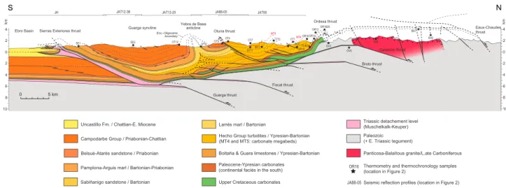
Figure 5. Balanced cross section of the eastern Jaca Basin (see Figure 2 for location). Surface data were compiled from published maps [Puigdefábregas Tomás, 1975; Gil Peña et al., 1990; Rios Aragües et al., 1990; Montes Santiago, 1991; Ternet et al., 2003; Millán Garrido, 2006], complemented with ownfield observations. Subsurface structures are derived from the seismic interpretation shown in Figure 6. Seismic profiles and projected thermometry and apatite fission track samples are located in Figure 2.
3.1.1. Eaux-Chaudes Thrust
To the north, the cross section intersects the Eaux-Chaudes thrust in basement rocks. In the thrust footwall, the top of basement (base of the Upper Cretaceous carbonates) is represented above the present-day topo-graphy by projecting outcrops located more to the west (Figure 2). In the hanging wall, we infer an eroded basement thrust unit, represented schematically with ~10 km displacement on the basis of the minimum displacement of 7 km observed more to the west in the Ossau valley [Ternet et al., 2003].
3.1.2. Gavarnie Thrust
Immediately south of the Axial Zone, the syncline geometry of the sedimentary cover corresponds to the frontal limb of the Gavarnie thrust hanging wall culmination and allows locating the hanging wall cutoff of the basement. In the cross section, the elevation of the Gavarnie thrust is projected from the Gavarnie win-dow (Figure 2) with a moderate westward plunge.
3.1.3. Broto, Fiscal, and Guarga Thrusts
In the Jaca Basin, seismic profiles feature a group of deep high-amplitude reflections, about 300 to 400 ms thick, which correspond to the Upper Cretaceous to Eocene carbonates (Figure 6). The base of this group of reflectors is used as a proxy for the top of the nonreflective Paleozoic basement, which shows a southward dip from the southern edge of the Axial Zone to the axis of the Guarga syncline, where it reaches a depth of approximately 6000 m below sea level. More to the south, the basement top displays a gentle northward dip corresponding to the forelandflexure. The inflection point corresponds to the leading edge of the basement thrust system, i.e., the Guarga thrust hanging wall cutoff [Millán Garrido, 2006; Millán Garrido et al., 2006]. Steps in the imaged top of basement are interpreted as the hanging wall cutoffs of two other major thrusts, from north to south the Broto and Fiscal thrusts. The Broto thrust was already inferred in previous sections of the Jaca Basin (cf. above) while the Fiscal thrust has not been described before.
Displacement on the Gavarnie, Broto, Fiscal, and Guarga thrusts can be only indirectly estimated from the analysis of their hanging wall culminations according to the fault-bend fold model [Suppe, 1983], as was attempted by Teixell [1996] in the western Jaca Basin. Although a strict application of this model can be ques-tioned because it may not adequately represent the deformation kinematics of the basement, it gives a basis for interpreting the fault-fold structure and determining plausible ranges of displacement values.
Projection of the Gavarnie thrust and its hanging wall culmination results in 8–10 km of thrust displacement transfer, assuming a crestal-uplift stage of fault-bend folding for the structure. This value matches the mini-mum 7 km displacement observable in the Gavarnie window to the east and the 10 km inferred by Teixell [1996] more to the west. The Gavarnie thrust is folded by the crest of the Broto thrust hanging wall culmina-tion, the geometry of which implies a displacement of 10.4 km on the later thrust. Aflat top on the Fiscal thrust hanging wall culmination is not observed in seismic profiles close to the studied cross section, which, atfirst sight, could indicate a large hanging wall ramp with a minimum displacement of 13.2 km. However, we consider this value excessive as the seismic profiles show that the studied cross section is oblique to the trace of this thrust, oriented NW-SE in this area. A few kilometers to the east, the crest of the culmination is visible in
Figure 6. Interpretation of merged seismic reflection profiles JAT12-38, JAT12-20, JA88-05, and JAT95 from the eastern Jaca Basin (profiles available from the IGME website:<www.igme.es>). The line traces are shown in Figure 2 and follow approximately the cross section presented in Figure 5. Lithostratigraphic units: BAM + CG: Belsué-Atarés sandstone and Campodarbe Group; C-EC: Upper Cretaceous to lower Eocene carbonates; GL: Guara limestone; HG + LM: Hecho Group turbidites and Larrés marl; PAM: Arguis-Pamplona marl; PZ: Paleozoic; and SS: Sabiñánigo sandstone. Cover structures: OT: Oturia thrust; SET: Sierras Exteriores thrust; and YBT: Yebra de Basa thrust. Basement thrusts: BT: Broto thrust; FT: Fiscal thrust; GT: Guara thrust; and arrows: onlap of HG turbidites.
seismic profiles, allowing an estimation of displacement of 7–10 km for the Fiscal thrust. Finally, the geometry of the culmination of the Guarga thrust indicates a displacement of 4.8 km. These estimations are further discussed below (section 3.3).
3.2. Cover Thrusts
Four major cover thrusts are identified in the Jaca Basin along the studied cross section, which from north to south are the Ordesa, Oturia, Yebra de Basa, and Sierras Exteriores thrusts (Figure 5).
3.2.1. Ordesa Thrust
As discussed above, the Ordesa thrust corresponds to the sole thrust of the Monte Perdido thrust system, connected to the north to the Eaux-Chaudes basement thrust. The Ordesa thrust ramp across the carbonates is projected above the present-day topography from its exposure a few kilometers to the east (Figure 2). This ramp is here localized above the Gavarnie basement thrust culmination, and therefore, the two thrusts cannot be connected (cf. discussion above). To the south, the Hecho Group turbidites are affected by chevron folding at tens to hundreds of meter scale with axial plane regional cleavage [Ten Haaf et al., 1970; Séguret, 1972; Mutti et al., 1988; Holl and Anastasio, 1995; Millán Garrido et al., 2006; Izquierdo-Llavall et al., 2013]. In seismic profiles, these intensely folded turbidites are transparent whereas high-amplitude reflections corre-sponding to the underlying carbonates show a gentle folding (Figure 6). Accordingly, the chevron folding is interpreted as the frontal deformation of the Monte Perdido thrust system above a detachment located at the top of the carbonates.
The shortening by the Monte Perdido thrust system can hardly be determined in the study section, as most of the thrust unit is eroded. Shortening on the Ordesa thrust is probably around 1–2 km, based on its outcrop to the east (Figure 2). In the Monte Perdido massif, about 3 to 4 km of additional shortening occurs in the upper thrust units detached in the Campanian-Maastrichtian carbonates [e.g., Trincal et al., 2014]. Hence, about 5 km of shortening can be inferred for the Monte Perdido thrust unit, but this is a minimum value as most of the unit is eroded above the Axial Zone. However, this value is consistent with that measured by Teixell [1996] on the equivalent Larra thrust at the western termination of the Axial Zone (Figure 1). As discussed above, the Ordesa thrust is dated as Lutetian-Bartonian from its lateral connection to the Añisclo and Boltaña anticlines.
3.2.2. Oturia Thrust
South of the zone of chevron folding, the turbidites dip gently northward in the hanging wall of the Oturia thrust. Seismic profiles show that the thrust dips moderately northward across the entire clastic succession, with the turbidites featuring a low-angle hanging wall ramp (Figure 6). Below the turbidites affected by chevron fold-ing, seismic profiles show a thrust-fold structure in the carbonates, with a footwall ramp connected to the Triassic detachment level. The front of the structure is less well imaged and is interpreted as a duplex connected to the emerging Oturia thrust (Figure 5). In its footwall, the Oturia thrust cuts the northern limb of the Cancias syncline, which displays a fan geometry attesting folding during deposition since the Pamplona marl until the Santa Orosia conglomerate (lower Campodarbe Group), i.e., during most of the Priabonian. A few kilometers eastward, the Rupelian conglomerates (upper Campodarbe Group) do not show a fan geometry in the northern limb of the syncline. This structure suggests that the Oturia thrust derives from a Priabonian fault propagation fold cut by a late (late Priabonian-early Rupelian?) break-back thrust that propagated across the anticline hinge. Shortening on the Oturia thrust measured at the top of the carbonates is of 4.9 km.
3.2.3. Yebra de Basa Thrust-Fold Structure
The Cancias syncline is followed southward by the Yebra de Basa anticline. The steeply dipping limbs of the anticline are not clearly imaged in seismic profiles, while at depth there is a thrust-fold structure in the carbo-nates that we here define as the Yebra de Basa thrust (Figure 6). The tight geometry of the Yebra de Basa anticline observed at the surface implies a strong disharmony between the carbonates and overlying clastic succession, schematically represented as a multidetachment thrust system withfishtail thrust geometry, simi-lar in style to other disharmonic thrust-fold systems [e.g., Harrison, 1995; Dengfa and Suppe, 2005]. We observed that the limbs of the Yebra de Basa anticline feature growth strata in the Campodarbe Group, attesting a late Priabonian-Rupelian age for the Yebra de Basa thrust-fold structure. However, erosion precludes observation of the end of folding. Shortening on the Yebra de Basa thrust measured at the top of the carbonates is 4.8 km.
Hence, the subsurface interpretation reveals connections of the Oturia thrust and Yebra de Basa anticline with deep thrust ramps across the carbonates. The westward lateral transition of the Yebra de Basa anticline
to the Foz de Binies and Sierra de Illon thrust-fold structures involving the carbonate succession [Labaume et al., 1985; Teixell and Garcia-Sansegundo, 1995] further supports this interpretation. This differs from the interpretation by Millán Garrido et al. [2006] who related these two structures to a detachment located at the top of the carbonates and connected to the Ordesa thrust.
3.2.4. Sierras Exteriores Thrust
Below the southern limb of the Guarga syncline, seismic profiles show the footwall ramp of the Sierras Exteriores thrust cutting across the whole succession and a detachment in the Keuper-Muschelkalk in the hanging wall [Millán Garrido, 2006; Millán Garrido et al., 2000, 2006] (Figure 6). In the hanging wall succession, the lateral transition between the Guara limestone and the Hecho Group turbidites is visible on seismic profiles, with the turbidites onlapping erosional surfaces truncating the carbonates [Barnolas and Teixell, 1994] (Figure 6). The seismic profiles also image the wedge geometry of the whole Eocene succession, thick-ening northward and folded by the Guarga syncline. To the south, the leading edge of the Sierras Exteriores thrust sheet features a break-back thrust system cutting the cover succession up to the lower Miocene sediments of the Uncastillo Formation [Millán Garrido, 2006; Millán Garrido et al., 2000, 2006]. The frontal unit, visible on seismic lines and cropping out 5 km to the east, is buried below the Uncastillo Formation, and its hanging wall ramp is eroded [Millán Garrido, 2006; Millán Garrido et al., 2000, 2006]. Growth strata in the Uncastillo Formation date the break-back thrust sequence to the Chattian-early Miocene. However, the onset and end of Sierras Exteriores thrusting are difficult to determine on the cross section analyzed here and are discussed below. Shortening on the Sierras Exteriores thrust measured at the top of the carbonates is of 21.6 km, but this is a minimum value as the hanging wall ramp of the frontal unit is eroded.
3.3. Kinematic Relationships Between Cover and Basement Structures
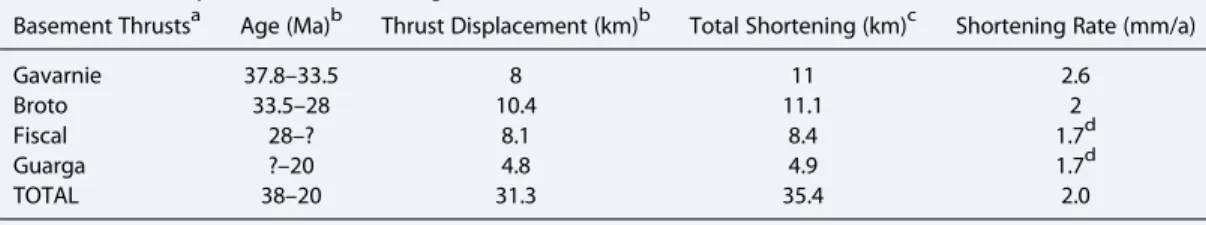
The kinematic relationships discussed in this section are illustrated in the geochronological scheme of Figure 4 and summarized in Table 1 for the basement thrusts.
We have discussed above that the Eaux-Chaudes thrust comprises an eroded basement thrust sheet and a lower branch is connected to the Monte Perdido thrust system along a décollement above the Axial Zone, with speculative displacements around 10 km and 5 km, respectively. The Lutetian-Bartonian age of the Monte Perdido thrust system corresponds to the last stage of activity of the Eaux-Chaudes thrust. The onset of thrusting is more difficult to ascertain from available data. Absolute datings around 48–50 Ma by Wayne and McCaig [1998] and Jolivet et al. [2007] of shear zones cutting the Néouvielle granite and connected to the Eaux-Chaudes thrust (Figure 2) suggest that the latter was active from at least the early Eocene, before its propagation into the Jaca Basin (Figure 4).
The displacements on the Gavarnie, Broto, Fiscal, and Guarga basement thrusts are transferred to the cover through the Triassic décollement level. Deformation of the latter above the basement hanging wall culmina-tions indicates a piggyback thrusting sequence for the four basement thrusts. However, determining precisely the kinematic relationships between the latter and the cover structures is not straightforward because they are separated by the décollement level. In the following, we attempt to balance displacements between the base-ment and cover structures for the different stages of deformation deduced from growth strata.
Seismic profiles show that the Oturia thrust can be connected only to the Gavarnie thrust (Figure 6), demon-strating for the latter a minimum displacement of 4.9 km during the Priabonian (-early Rupelian?). Hence, some displacement on the Gavarnie thrust must have been transferred south of the Oturia thrust to account
Table 1. Summary of Basement Thrust Ages and Kinematic Values
Basement Thrustsa Age (Ma)b Thrust Displacement (km)b Total Shortening (km)c Shortening Rate (mm/a)
Gavarnie 37.8–33.5 8 11 2.6
Broto 33.5–28 10.4 11.1 2
Fiscal 28–? 8.1 8.4 1.7d
Guarga ?–20 4.8 4.9 1.7d
TOTAL 38–20 31.3 35.4 2.0
aThrusts are shown in Figure 5. b
Ages and displacements are discussed in the text.
cSum of thrust displacement and hanging wall deformation. d
for the total of 8–10 km discussed above. However, the possibility that the 4.8 km displacement on the Yebra the Basa thrust is entirely related to the Gavarnie thrust is here discarded on the basis of the sequential restoration of the section, because it would imply insufficient elevation with respect to the basin and hence insufficient erosion of the Axial Zone during this period (see below, section 5). As a compromise, we propose (i) that the Gavarnie thrust was active during the Priabonian-earliest Rupelian with 8 km displacement, distrib-uted in 4.9 km on the Oturia thrust during the whole period and 3.1 km on the Yebra de Basa thrust-fold from the late Priabonian, and (ii) that the 10.4 km displacement on the Broto thrust started in the earliest Rupelian and was partitioned into 1.7 km completing the Yebra de Basa thrust-fold and 8.7 km transferred to the Sierras Exteriores thrust. The onset of the Sierras Exteriores thrusting probably occurred during the early-middle Rupelian, similarly to the western Sierras Exteriores where it is dated to 31.3 Ma by the emplacement of the San Felices unit [Hogan and Burbank, 1996; Millán Garrido et al., 2000; Oliva-Urcia et al., 2015] (Figure 4). We note that the age here inferred for the Gavarnie thrust is consistent with the 36.5 Ma40Ar/39Ar age of authigenic illite from the Gavarnie thrust fault zone [Rahl et al., 2011]. The relays between the Broto, Fiscal and Guarga basement thrusts are difficult to determine with precision as the three thrusts are connected to the Sierras Exteriores thrust. The onset of the Fiscal thrust, uplifting the northern limb of the Guarga syn-cline, may have induced the end of the Campodarbe sedimentation in the Jaca Basin. The latter is not pre-cisely dated as the preserved top of the succession (28.4 Ma according to Oliva-Urcia et al. [2015]) is an erosional surface, but we infer that the weathering-resistant San Juan de la Peña conglomerates present at the top of the Campodarbe Group are witnesses of the last sedimentation events. Hence, we assume that the onset of Fiscal thrusting may have occurred around 28 Ma. As the displacements on the Fiscal and Guarga thrusts (4.8 km for the latter) were transferred to the Sierras Exteriores thrust, the total shortening of 21.6 km calculated for the latter implies a displacement of 8.1 km for the Fiscal thrust, in agreement with the estimate discussed above. However, this is only a minimum value as the frontal unit of the Sierras Exteriores thrust system is eroded. This incertitude is discussed further below as it also has implications related to the N-S folding of the Sierras.
As the displacement on the Guarga thrust is smaller than on the Fiscal thrust, we assume that the relay between the two occurred during the late Chattian. We note that attributing the onset of the Guarga thrust-ing at the beginnthrust-ing of the Oligocene, as proposed by Fernández et al. [2012], implies that the Yebra de Basa thrust was connected to the Guarga thrust by a back directed detachment, a hypothesis for which there are no clues. Growth strata at the Sierras Exteriores show that the emergence of the Fiscal-Guarga thrusting continued until the early Miocene. More to the west, the youngest syntectonic sediments are dated around 22–23 Ma (Aquitanian) [Hogan and Burbank, 1996; Arenas et al., 2001], but the youngest thrusts developed in a break-back sequence attest to a more recent age (up to early Burdigalian?) for the end of tectonic activity [Millán Garrido et al., 2000]. In the following, we assume an end of the shortening around 20 Ma.
The shortening values (i.e., the sum of the fault displacement and hanging wall deformation) inferred from the cross section in Figure 5 for the Gavarnie, Broto, Fiscal, and Guarga basement thrusts are shown in Table 1. From these values, we derive an evolution of the shortening rates from 2.2 mm a 1for the Gavarnie and Broto thrusts to 1.7 mm a 1for the Fiscal and Guarga thrusts considered together. Although the accuracy of these calculations is limited by the uncertainties on the shortening values and thrusting ages, they suggest a progressive reduction of shortening rates across the wedge front. The rates here calculated are higher than those calculated by Teixell [1996] on the Ansó section for the equivalent structural domain (i.e., south of the Lakora thrust), but this is not surprising as the total shortening decreases from east to west in the south central Pyrenees.
3.3.1. The N-S Folds of the Sierras Exteriores
These folds do not appear in the study cross section which follows the axis of the Belsué syncline, close to the eastern limb of the Pico del Aguila anticline (Figure 2). The latter registered about 2.6 km shortening, dated by growth strata from the early Bartonian to early (middle) Priabonian [Poblet and Hardy, 1995; Hogan and Burbank, 1996] (Figure 4), and rotated clockwise about 40°during its growth [Pueyo et al., 2002]. East of the Sierras Exteriores, the Boltaña anticline is reported to have rotated about 52° clockwise during Ypresian to middle Priabonian times, 40° of which from the late Lutetian and partially postfolding [Mochales et al., 2012; Muñoz et al., 2013]. Hence, the growth and rotation of the Sierras Exteriores N-S folds was contemporaneous of most of the Boltaña anticline rotation, during the last stage of the Eaux-Chaudes/Monte Perdido thrusting and part of Gavarnie thrusting. These kinematic relationships lead to interpret the Sierras Exteriores N-S folding as the result
of a westward propagation of deformation in the foreland of the Boltaña anticline [Mochales et al., 2012], and hence, we do not relate it to the N-S shortening across the Jaca Basin, which propagated into the Sierras Exteriores frontal thrust ramp during the early-middle Rupelian (cf. above).
We infer that the rotation of the Sierras Exteriores folds may have implied the existence of a frontal E-W structure to separate the rotating domain from thefixed foreland. If it existed, this speculative structure is now eroded and the amount of contraction that it may have accommodated is unknown. Together with the erosion of the leading edge of the Sierras Exteriores thrust system, this contributes to the uncertainty on the N-S component of shortening on the Sierras Exteriores thrust.
4. Thermometry and Thermochronology
4.1. MethodologyVitrinite reflectance measurements and Raman spectroscopy of carbonaceous material were used to deter-mine the maximum paleo-temperatures that affected the Jaca Basin sediments along the studied section, while apatite fission track thermochronology allowed description of part of the exhumation history. Measurements were made on sandstone samples, coupling the three methods on the same sample wherever possible. The principles of the methods are described below. Technical details of analyses are given in the Appendix A.
4.1.1. Thermometry
4.1.1.1. Vitrinite Reflectance Measurements
Vitrinite is a vitreous organic material derived from the thermal evolution of botanic tissues mainly composed of lignin and cellulose [Suárez-Ruiz et al., 2012]. The determination of vitrinite reflectance, measured under the microscope as the percentage of light reflected by a polished preparation in oil immersion, is a key method to estimate the level of thermal maturation of organic matter which evolved in the range of maxi-mum paleotemperatures of 50–300°C. Here we report mean reflectance values (random reflectance, Rr%) measured under nonpolarized white light. Estimation of the maximum paleotemperature is made from the empirical correlation of vitrinite reflectance with independent thermal data (e.g., fluid inclusion data) com-piled from basins all over the world. In this study, we used the calibration chart published by Barker and Pawlewicz [1994] for burial heating, with uncertainty of about ± 30°C.
4.1.1.2. Raman Spectroscopy of Carbonaceous Material (RSCM)
Raman spectroscopy is an analytical method that yields information on the molecular structure of the matter. It can be used to study the evolution of the structure of carbonaceous material (CM) and consequently to evaluate the maximum paleotemperature reached by rocks containing CM [Beyssac et al., 2002; Lahfid et al., 2010]. Spectra of perfect graphite are generally composed of one band situated at 1580 cm 1. With the presence of disorder in the CM structure, additional bands, called defect bands, appear. In Raman spectra of very poorly ordered CM, at least four defect bands are observed [e.g., Sadezky et al., 2005; Lahfid et al., 2010], called the D1, D2, D3, and D4 bands and localized at 1350 cm 1, 1620 cm 1, 1500 cm 1, and 1200 cm 1, respectively. With the decrease of CM disorder, the defect bands disappear gradually, succes-sively the D4, D3, and then D1 and D2 bands. A summary of the assignments of the different bands is given in Sadezky et al. [2005]. Here quantification of spectra evolution has been made using the RA1 parameter described in Lahfid et al. [2010], and that can be used to determine maximum paleotemperatures in the range 200–330°C (with uncertainty of ± 25°C) for rocks containing type II-III kerogen and buried under normal geothermal gradient. Temperatures lower than 200°C (with a lower limit at approximately 160°C) were esti-mated qualitatively comparing the obtained spectra to those of the Glarus area [Lahfid et al., 2010].
4.1.2. Apatite Fission Track Thermochronology
Apatitefission track (AFT) thermochronology allows reconstruction of the thermal history of rocks through the temperature interval between ~120°C and ~60°C (the Partial Annealing Zone, PAZ) [e.g., Fitzgerald et al., 1995; Gallagher et al., 1998]. Over geological time scales,fission tracks in apatite anneal rapidly at tem-peratures higher than the PAZ whereas below 60°C, fission track annealing dramatically slows down to become nearly null. The limits of the PAZ may slightly vary sincefission track annealing is partially controlled by the chemical composition of the apatite [Donelick et al., 2005]. The Dpar parameter (defined as the diameter of the etch pit measured on crystal sections parallel to the< c > crystallographic axis) provides a relative estimate of thefission track annealing rate (varying with the chemical composition) in the individual
apatite crystals [Donelick, 1993, 1995; Burtner et al., 1994; Carlson et al., 1999; Barbarand et al., 2003b; Sobel and Seward, 2010]. This allows estimation of the annealing properties for each sample and provides a sample/grain specific temperature range for track annealing [e.g., Green et al., 1985; Crowley et al., 1991; Carlson et al., 1999; Barbarand et al., 2003a; Donelick et al., 2005]. In this study, Dparwas measured on each analyzed grain.
Several samples showed evidence of overdispersion by failing the chi test (P(χ2)< 10) and having significant (>20%) age dispersion (Table 3). In order to fully describe these mixed ages, the single-grain age distribution was decomposed into statistically representative age populations or peaks ages using the BinomFit® software [Brandon, 2002]. Some other samples showing not negligible dispersion values (>5%), BinomFit® modeling was performed on all samples for methodological consistency. The main characteristic of the AFT ages being to decrease with the temperature increase [e.g., Braun et al., 2006, Figure 3.8], statistical analyses allow us to qua-litatively estimate for each sample the resetting level and therefore to follow the burial evolution of the data set. In this study, thefission track age of each sample is expressed as the central age [Galbraith and Laslett, 1993] with ± 2σ uncertainties. Central ages seldom have a geological significance in terms of cooling age of the samples. In fact, detrital apatite age populations can correspond to three main scenarios (Figure 7):
Figure 7. (a) Principles of apatitefission track thermochronology applied to a foreland basin setting (modified after Braun et al. [2006]). In the source area, rocks are progressively exhumed toward the surface, through the Partial Annealing Zone (PAZ), then eroded and deposited in the foreland basin. The cooling age (tc) indicates the time at which the sample crossed
the lower boundary of the PAZ. In the thickest part of the foreland basin, apatite grains from the layers 1, 2 and 3, and 4 are totally, partially, and not reset, respectively. The transport time being negligible, the depositional age (td) is equal to the age
of exposure at the surface (te). (b) Significance of detrital apatite fission track ages. Variations in the apatite single-grain age
are spread according to the reset level, plotted on radial diagrams [Galbraith, 1990], and compared to the depositional age of the sample (thick dashed line).
1. Crystals were buried to temperatures higher than the PAZ (i.e.,> ~120°C), inducing a complete reset of the thermochronometer (provided that they remain during a long enough time above this temperature). The individual apatite single-grain ages are then younger than the stratigraphic age of the sample and generally form a single, low standard deviation group (Figure 7b). Apatitefission track results therefore describe the inversion history of the basin. However, in a sample that contains apatite crystals with strongly different annealing properties (i.e., issued from different sources), the dispersion can increase in relation to the residence time in the PAZ during postannealing cooling.
2. Crystals were buried to less than 60°C and not reset. The thermochronological signal then corresponds to their cooling history in the source area. On a radial plot (Figure 7b), the single-grain ages are older than (or equal to) the stratigraphic age of the sample and are generally widely scattered. The age dispersion reflects the diversity of the cooling ages of the source area, with several age populations usually revealed by statistical analysis. The central age for a sample with overdispersion is generally an average of the single-grain ages and without direct geological significance.
3. Crystals were buried to temperatures corresponding to the PAZ and partially reset. The single-grain ages are dispersed around the stratigraphic age of the sample (Figure 7b). The age dispersion is due either to the diversity of the cooling ages in the source area or to an important variability of the annealing rates of the individual grains (depending on their individual chemical composition) that can be highlighted by Dparmeasurements. The central age is a mixed age without geological significance, integrating source area cooling ages and the age at which the sediment exited the PAZ in the inverted basin.
4.1.3. Sampling Strategy and Sample Location
Samples for thermometry and AFT analyses were selected in order to constrain the burial and denudation history of the Jaca and NW Ainsa basins. Twenty-two samples were collected in the basinfill, from the base of the Hecho Group to the top of the Campodarbe Group. Thermometry measurements were also made on 16 of these samples. Seven additional samples for thermochronology were taken from the Paleozoic base-ment of the Axial Zone. Sample locations are shown in Figure 2 and are projected onto the cross section in Figure 5 according to their stratigraphic and structural locations and altitude (except OR14 and OR20 which are shown 1000 m higher than their actual altitude due to a lateral change of the Ordesa thrust geometry). Sample stratigraphic positions are indicated in Figure 10 where the samples from the Hecho Group turbidite succession are localized using the stratigraphic subdivisions (“turbidite systems”) of Remacha et al. [2003] and Caja et al. [2009].
Table 2. Paleothermometry Results
RSCM
Vitrinite Reflectance RA1 Parameter T (°C)
Samplea Rr% SD MN Q T (°C)b Mean SD Mean SD SE5 0.43 0,1 32 M 68 OT3 0.35 0,04 30 I <60 OT5 0.62 0,06 15 M 97 OT7 0.58 0.007 39 I 92 OT4 0.60 0.09 26 M 95 BC1 0.8 0.06 40 I 118 CT2 0.64 0.08 37 M 100 <160 20 CT1 1.51 0.11 40 I 169 <160 20 BC2 1.28 0.10 40 I 156 <160 20 OR19 1.93 0.17 32 L 189 180 20 OR16 2.58 0.21 40 M 212 180 20 TUR3 180 20 OR14 3.79 0.28 50 M 244 0.56 0.012 236 10 OR12 2.98 0.21 50 I 224 0.56 0.005 238 6 OR20 3.92 0.28 51 M 247 0.57 0.012 238 13 OR1 4.54 0.26 50 M 259 0.59 0.011 270 10 a
Samples are located on maps in Figures 2 and 8a, projected on cross sections in Figures 5 and 8b, and sample geographic coordinates are in Table 3; RSCM, Raman Spectroscopy of Carbonaceous Material; RA1 parameter, explanation in the text; Rr%, vitrinite mean reflectance (random reflectance); SD, standard deviation; MN, measurement number; Q, data quality (I, important; M, medium; L, low); T (°C), temperature.
b
4.2. Thermometry Results 4.2.1. Vitrinite Reflectance Results
Measurements of vitrinite reflectance were made on 12 samples distributed across the whole Hecho Group turbidite succession and three samples in Priabonian to Rupelian sediments in the footwall of the Oturia thrust. Results are given in Table 2, and corresponding max-imum paleotemperatures are reported in Figure 8. Except in one case, the result quality is moderate to good.
The Hecho Group samples show a marked decrease in vitrinite reflectance/maximum temperatures from bottom to top of the succession. Samples from the low-ermost part (samples OR1, OR12, OR14, and OR20 from the Figols turbi-dite system), collected in the Ordesa valley (southern flank of the Monte Perdido massif), yield reflectance values between 2.98% and 4.54%, corresponding to temperatures com-prised between 224 and 259°C accord-ing to the calibrations of Barker and Pawlewicz [1994]. Higher in the succes-sion, the reflectance (temperature) values decrease to (i) 1.93 to 2.58% (189 to 212°C) in the Broto turbidite system (samples OR16 and OR19), (ii) to 1.28 to 1.51% (156 to 169°C) in the lower part of the Cotefablo turbidite system (samples BC2 and CT1), and (iii) to 0.64 to 0.8% (100 to 118°C) in the upper part of the Cotefablo turbi-dite system (samples CT2 and BC1). The lowest reflectance values are found at the top of the succession, where the OT4 (Banaston turbidite system) and OT7 (Jaca turbidite system) samples yield values of 0.60 and 0.58%, respectively, corresponding to temperatures of 95°C and 92°C.
Sample OT5, in the Priabonian Santa Orosia conglomerate (lower Campodarbe Group) a few tens of meters below the Oturia thrust, has a reflectance value of 0.62% (97°C), similar to that of sample OT4 located 200 m above the thrust. In contrast, although being located about 1500 m lower in the succession, sample OT3 in the Bartonian Sabiñánigo sandstone yields a lower value of 0.35% (<60°C). Further to the south, sample SE5 corresponds to the youngest Campodarbe sediments preserved in the Guarga syncline on the studied section and has also a low reflectance value of 0.43% (68°C).
4.2.2. Raman Spectroscopy of Carbonaceous Material Results
The geothermometry approach of RSCM was conducted on 10 samples located in the stratigraphically lower turbidites. Characteristic spectra are shown in Figure 9, results are summarized in Table 2, and corresponding maximum paleotemperatures are reported in Figure 8.
The obtained spectra are composed of two broad bands, so-called D and G [e.g., Wopenka and Pasteris, 1993; Yui et al., 1996], located at ~1350 cm 1and ~1600 cm 1, respectively. The analysis of band widths reveals variations with increasing CM thermal maturity, i.e., when going downward in the stratigraphic column:
Figure 8. (a) Detail of map in Figure 2 and (b) detail of cross section in Figure 5 showing the distribution of maximum paleotemperatures in the Hecho Group turbidites of the northeastern Jaca Basin, deduced from vitrinite reflectance measurements (numbers in blue) and Raman spectroscopy of carbonaceous material thermometry (numbers in red). Complete analytical results and temperature interpretation are in Table 1. The stratigraphic position of samples is shown in Figure 10.
1. The width of the G band (including the G band stricto sensu and the D2 defect band) decreases before becom-ing almost constant when T exceeds ~200°C, i.e., from sample OR20 down-ward in Figure 9.
2. The width of the D band progressively decreases due to a gradual disappear-ance of defect bands such as the D4 band. The D band comprises at least two bands: the main defect band D1 located at ~1350 cm 1and the D4 band, located at ~1200 cm 1as a shoulder on the D1 band.
Samples OR1, OR14, OR12, and OR20 from the base of the Hecho Group (Figols turbidite system) in the Ordesa valley are characterized by Raman spectra indicating maximum paleotemperatures of 274°C, 262°C, 238°C and 211°C, respectively, with uncertainty of ± 25°C. However, sample TUR3 also located at the base of the succes-sion 20 km to the west yields spectra indi-cating a lower temperature peak, of ~180° C. Further up in the stratigraphic column, the spectra of samples OR16 and OR19 (Broto turbidite system) also indicate tem-perature peaks of ~180°C, and those of sam-ples CT1, CT2, and BC1a (Cotefablo turbidite system) record temperature peaks lower than 160°C.
4.2.3. Synthesis of Thermometry Results in the Hecho Group Turbidites
Thermometry shows maximum paleotemperatures decreasing upward across the Hecho Group turbidite suc-cession, with a goodfirst-order correlation (within the uncertainty margin) between temperatures deduced from the RSCM method and those deduced from vitrinite reflectance for temperatures >160°C (Figure 8). The highest temperatures are found at the base of the succession near the Ordesa valley, with mean values by both methods around 240°C (samples OR1, OR12, OR14, and OR20). Temperatures rapidly decrease to around 180–200°C about 1000 m higher in the stratigraphic column (samples OR16 and OR19). This result points to a high geothermal gradient around 50°C/km for the lower part of the succession in the Ordesa-Broto area (54° C/km if we compare the mean of temperature values obtained for samples OR16 and OR19 with those obtained for samples OR1, OR12, OR14, and OR20). However, this temperature distribution is specific to this area as a temperature of only about 180°C is found 20 km to the west at the base of the succession (sample TUR3), i.e., in a stratigraphic position equivalent to that of the higher-temperature Ordesa samples. Higher up section, the temperature decreases progressively to 90–95°C (vitrinite reflectance data) in the uppermost tur-bidites in the hanging wall of the Oturia thrust (samples OT4 and OT7). Gradients calculated using the strati-graphic thickness remain higher in the eastern part of the study area (about 35°C/km between samples OR16–OR19 and OT7) than in the western part (about 25°C/km between samples TUR3 and OT4). Although these calculations must be taken with caution due to the large uncertainties attached to the paleo-temperature estimations and the relatively large distances between sampling sites, they point to a nonhomo-geneous temperature distribution with a high gradient at the base of the turbidite succession in the northeastern part of the study area and much lower gradients in the western area and the upper part of the succession. These results are in general agreement with those of Izquierdo-Llavall et al. [2013] who studied the paleothermometry of the northern Jaca Basin using a combination offluid inclusions, illite content in
Figure 9. Characteristic spectra obtained for 10 samples (located on Figure 2) by Raman spectroscopy of carbonaceous material. See text for interpretation.
mixed illite-smectite layers, Kübler index, and vitrinite reflectance data. Although their data are scarce in the area studied here and the paleotemperatures obtained are slightly lower than ours, their results confirm the elevated temperatures at the base of the turbidite succession in the Ordesa area (Rr% of 1.89 close to our OR16 sample) and relatively lower temperatures in the same stratigraphic position more to the west (Rr% of 1.32 close to our TUR3 sample).
Hence, the very high temperatures found at the base of the Hecho Group turbidites at Ordesa appear as an anomaly both from the high thermal gradient they imply in the lowermost part of the succession, unexpected in this foreland basin context, and from the fact that a lower temperature is found laterally in an equivalent stratigraphic position. Below, we discuss the possible origin of these elevated tem-peratures (section 4.4) and refine inferences on geothermal gradients using the structural restoration (sec-tion 5).
4.3. Apatite Fission Track Results
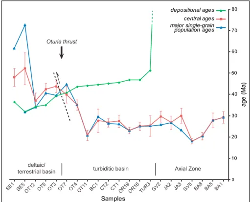
The results are reported in Table 3, and diagrams offission track analytical data versus stratigraphic position are presented in Figure 10. Figure 11 summarizes the evolution of the AFT central ages and mean ages of the main statistical single-grain age populations for the various samples according to depositional ages. The Dpar measurements performed on selected samples are presented in Figure 12.
4.3.1. Axial Zone
Result from the Axial Zone are presented in Figure 10a.
Granite samples GV5, from the Gavarnie thrust footwall, is fully reset with a central age of 18.2 ± 1.2 Ma. Granite samples BA1, from the top of the Gavarnie thrust hanging wall culmination, and BA5 and BA8,
Table 3. Apatite Fission Track Thermochronology Results
Samplea Latitude Longitude
Altitude (m) N ρd × 105 (Counted) ρd × 105 (Counted) ρd × 105 (Counted) [U] (ppm) P(χ2) var (%) Central Age ± 2σ (Ma) Dpar (μm) BA1 N42°50′20 ′′ W0°17′25′′ 3137 20 14.14 (8282) 2.24 (136) 18.52 (1123) 14.9 42.45 1 29.3 ± 2.7 2.10 BA5 N42°51′29 ′′ W0°17′22′′ 2080 20 13.47 (8282) 1.82 (74) 15.08 (611) 13.87 100 1 27.9 ± 3.5 1.9 BA8 N42°45′15 ′′ W0°14′22′′ 1614 20 13.87 (8282) 2.43 (156) 28.13 (1806) 24.51 98.06 0 20.5 ± 1.8 2.10 GV2 N42°42′39′′ W0°03′25′′ 2212 23 13.63 (12,288) 3.4 (172) 25.84 (1308) 22.69 34.46 14 29.6 ± 2.6 _ GV5 N42°43′60′′ W0°00′32′′ 1388 18 12.34 (10,996) 6.05 (245) 66.82 (2706) 64.3 97.53 0 18.2 ± 1.2 2.00 JA2 N42°47′45′′ W0°31′27′′ 1632 20 10.92 (7145) 1.95 (91) 13.58 (634) 17.72 93.19 2 26.8 ± 3.1 _ JA3 N42°47′60′′ W0°31′15′′ 1641 16 11.27 (7373) 4.18 (156) 29.1 (1087) 32.67 1.85 26 30.0 ± 3.5 _ TUR3 N42°39′26′′ W0°19′18′′ 960 12 12.04 (12,288) 3.98 (32) 30.78 (248) 29.67 51.73 0 25.3 ± 4.8 _ OR1b N42°40′09′′ W0°00′52′′ 2580 OR12b N42°38′11′′ W0°03′38′′ 2120 OR14b N42°38′49′′ W0°06′53′′ 1230 OR16 N42°33′37′′ W0°08′43′′ 2281 31 11.22 (11,307) 4.9 (217) 35.64 (1580) 38.87 93.59 0 25.1 ± 1.9 2.32 OR19 N42°36′36′′ W0°07′10′′ 918 43 13.74 (12,632) 3.45 (257) 33.33 (2480) 30.49 84.61 0 23.2 ± 1.6 _ OR20b N42°40′35′′ W0°04′53′′ 2848 CT1 N42 37’30" W0°12’21" 1700 18 8.86 (9558) 4.56 (115) 23.99 (606) 27.02 58.86 6 27.5 ± 2.9 _ CT2 N42°35′49′′ W0°13′49′′ 1997 20 11.98 (12,632) 3.52 (198) 26.1 (1470) 28.59 71.1 0 26.3 ± 2.0 2.39 BC1 N42°35′28′′ W0°18′36′′ 859 12 13.3 (7978) 0.55 (29) 4.54 (238) 3.85 98.19 0 27.7 ± 5.5 OT3 N42°29′25′′ W0°16′56′′ 896 44 8.68 (9101) 8.5 (518) 28.62 (1744) 37.4 7.94 16 43.7 ± 2.7 _ OT4 N42°32′04′′ W0°16′06′′ 1920 40 7.83 (9101) 4.72 (293) 17.11 (1063) 26.45 89.71 2 35.2 ± 2.4 _ OT5 N42°31′37′′ W0°16′22′′ 1635 38 10.37 (9101) 4.92 (794) 21.01 (3389) 30.2 0.02 25 42.5 ± 2.7 1.49 OT7 N42°33′23′′ W0°13′15′′ 1550 27 9.95 (9101) 4.7 (234) 18.6 (925) 30.93 4.31 27 41.5 ± 4.0 1.35 OT11 N42°34′26′′ W0°17′56′′ 875 17 14.11 (12,632) 2.59 (84) 28.64 (929) 23.37 99.97 0 20.8 ± 2.4 2.49 OT12 N42°26′53′′ W0°15′09′′ 1503 22 11.61 (12,632) 2.33 (174) 12.3 (920) 16.77 10.26 20 37.1 ± 3.6 _ SE1 N42°18′22′′ W0°21′31′′ 963 40 11.86 (11,266) 4.79 (319) 19.82 (1321) 18.91 0.31 33 48.1 ± 4.2 _ SE5 42°23′45′′ W0°23′34′′ 815 18 12.26 (12,632) 5.28 (109) 24.17 (499) 20.92 2.47 32 52.2 ± 7.5 2.57 AS1 N42°36′49′′ E0°0.4′29′′ 2100 11 10.19 (10,996) 2.90 (36) 18.73 (232) 25.27 57.84 8 26.0 ± 4.7 _ AS3 N42°34′54′′ E0°06′24′′ 1499 18 11.98 (10,996) 4.18 (108) 25.57 (661) 11.98 14.1 11 32.5 ± 3.6 _ AS5 N42°31′21′′ E0°07′57′′ 863 10 11.62 (10,996) 3.89 (60) 25.85 (399) 28.6 95.55 0 28.5 ± 4.0 _ AS6 N42°24′13′′ E0°08′55′′ 554 39 10.88 (11,582) 4.43 (290) 31.85 (2086) 38.61 98.52 0 28.4 ± 1.9 _
aSamples are located on the map in Figure 2, projected on the cross section in Figure 5 and located against the stratigraphy with AFT result diagrams in
Figure 10; N, number of grains;ρd, standard track density; ρs and ρI, spontaneous and induced track densities, respectively; P(χ2),probability of c2 for v degrees of freedom (where v is number of crystals minus 1).
b
Figure 10. Apatitefission track data from the Axial Zone (a), the Hecho Group turbidites in the Jaca and Ainsa basins (b and c, respectively) and the Guarga syncline (d). Data are expressed as radial diagrams (central column) [Galbraith, 1990] and corre-sponding statistical decomposition of single-grain age distribution into a set of component distributions with the BinomFit® software (right column) [Brandon, 2002], using the binomial“peak-fitting” method of Galbraith and Green [1990] and Galbraith and Laslett [1993]. Dashed lines in the radial diagrams indicate either the sample depositional age (for sediments) or crystallization age (for granitic rocks). Apatitefission track results are plotted against a synthetic stratigraphic column of the Axial Zone and Jaca Basin (modified from Caja et al. [2009] for the Hecho Group turbidites). The stratigraphic position of samples from the Ainsa Basin (Figure 10c) is plotted at the equivalent position on the stratigraphic column in Figure 10b. Samples are located in Figures 2, 5, and 8.
situated some 1000 m and 1500 m below, respectively, are again fully reset with central ages of 29.3 ± 2.7 Ma, 27.0 ± 3.5 Ma, and 20.5 ± 1.8 Ma, respectively.
Paleozoic samples GV2, JA2, and JA3, from the toe of the Gavarnie thrust sheet, have central ages ranging between 26.8 ± 3.1 Ma and 30.0 ± 3.5 Ma. Sample JA3 displays a significant dispersion of the single-grain ages (var% = 26 and P(χ2) = 1.8; Table 3) which are all much younger than the stratigraphic age. Sample GV2 also shows a significant dispersion (var% = 14) but did not fail the χ2test (Table 3). Statistical analysis shows the existence, in samples GV2 and JA3, of two age populations in which the major one (i.e.,
corresponding to the majority of the single-grain ages) has a mean age of 25.6 Ma (GV2) and 23.3 Ma (JA3). Sample JA2 presents only one age population. The fact that in the three samples, the single-grain ages are all much younger than the Paleozoic stratigraphic ages argue for a total reset-ting. The strong dispersion of the single-grain ages in sample JA3 and, to a lower extend in sample GV2, could be explained by the high number of inclu-sions within the crystals that lead to errors in age determination. The cooling ages of samples GV2 and JA3 are there-fore likely to correspond to the age of the main age populations, i.e., 25.6 Ma and 23.3 Ma, respectively. These are con-sistent with the cooling age of 26.8 ± 3.1 Ma obtained for sample JA2.
4.3.2. Hecho Group Turbidites
Result diagrams from the Hecho Group turbidites are presented in Figures 10b and 10c for the Jaca and Ainsa basins, respectively. These samples provided few apatite crystals with low track num-bers linked to low238U content. In the Jaca Basin, samples OR1, OR12, OR14, and OR20 from the base of the succession (Figols turbidite system), collected around the Ordesa valley (Figure 2), could not be analyzed due to the very low number and bad preserva-tion of apatite crystals. Sample TUR3 col-lected at the same stratigraphic level more to the west (Figure 2) contained apatite crystals that yielded a central age of 25.3 ± 4.8 Ma, much younger than the stratigraphic age (~50–51 Ma). Although a few single-grain ages older than 50 Ma could suggest that thefission track reset might not have been total, the statistical parameters indicate a single age population confirmed by the BinomFit® model. Complete resetting is thus considered for sample TUR3.
Higher in the succession, samples OR16 and OR19 (Broto turbite system) have central ages of 25.1 ± 1.9 Ma and 23.2 ± 1.6 Ma, respectively. Although the calculated variance is very low and the samples did not fail theχ2test, single-grain ages form a relatively dispersed single population (especially in OR19), with most of the ages spanning from close to the stratigraphic age (~49–50 Ma) to around 15–20 Ma (early Miocene). The unimodal single-grain age distributions, associated to the scattering of the ages up to the stratigraphic ages suggest major but possibly not total reset.
The central ages of samples TUR3, OR16 and OR19 are similar to the exhumation ages observed in the Paleozoic samples of the Gavarnie thrust sheet (GV2, JA2, and JA3; Figure 10a), further attesting to a probable near total reset. Based on this observation, the central ages of these samples can be considered as close to the exhumation age.
![Figure 1. Structural sketch map of the Pyrenean orogen (simpli fi ed after Teixell [1996])](https://thumb-eu.123doks.com/thumbv2/123doknet/14783978.597894/3.918.308.816.136.413/figure-structural-sketch-map-pyrenean-orogen-simpli-teixell.webp)


![Figure 12. Radial plot diagrams [Galbraith, 1990] showing the relation between the D par value and apatite single-grain ages in a selection of strongly to totally (OR16, CT2, and OT11) and partially to not/very weakly reset (OT7, OT5, and SE5) samples](https://thumb-eu.123doks.com/thumbv2/123doknet/14783978.597894/24.918.111.804.136.620/figure-radial-diagrams-galbraith-relation-selection-strongly-partially.webp)
