HAL Id: hal-01892026
https://hal.archives-ouvertes.fr/hal-01892026
Submitted on 10 Oct 2018HAL is a multi-disciplinary open access archive for the deposit and dissemination of sci-entific research documents, whether they are pub-lished or not. The documents may come from teaching and research institutions in France or abroad, or from public or private research centers.
L’archive ouverte pluridisciplinaire HAL, est destinée au dépôt et à la diffusion de documents scientifiques de niveau recherche, publiés ou non, émanant des établissements d’enseignement et de recherche français ou étrangers, des laboratoires publics ou privés.
A new database structure guiding the combination of
geophysical methods for levee investigation
Théo Dezert, Sergio Palma-Lopes, Yannick Fargier, Philippe Cote, Clara
Jodry
To cite this version:
Théo Dezert, Sergio Palma-Lopes, Yannick Fargier, Philippe Cote, Clara Jodry. A new database struc-ture guiding the combination of geophysical methods for levee investigation. 23rd European Meet-ing of Environmental and EngineerMeet-ing Geophysics, Sep 2017, MALMÖ, France. 5p, �10.3997/2214-4609.201702047�. �hal-01892026�
Tu 23P2 06
A New Database Structure Guiding the Combination
of Geophysical and Geotechnical Methods for Levee
Investigation
T. Dezert (IFSTTAR-Cerema), S. Palma-Lopes (IFSTTAR), Y. Fargier (Cerema), P. Côte (IFSTTAR), C. Jodry* (IPGS - Université de Strasbourg)
Summary
In this study, we introduce a new database framework for levee investigation. We are considering on an equal footing geophysical and geotechnical investigation methods in order to assist the agencies and levee managers in selecting the most relevant methods for the levees’ characterization. For this to be possible, we are taking into account the environmental constraints, the pathologies and the failure modes of the levees. The other aspect of this work is to open new ways of reflection in the research community with an important bibliographic work being carried out. We first focus on the relations between pathological physical properties and failure modes of a levee in order to identify which properties and characteristics of a levee need to be estimated. Then, we display our new database framework using the example of the Electrical Resistivity Tomography method. This work finally insists on the benefits of such a structure to propose new method investigation combinations and to provide a significant quantity of references for the research community.
Introduction
In France, about 8 000 km of levees have been identified (Mériaux et al., 2005). These structures, as per Decree n°2007-1735 (12/11/2007), are considered as “hazardous structures” and require specific survey in order to prevent the risk of failure which can lead to human losses (53 casualties attributed to the flooding in La Faute-sur-Mer in 2010) and economic disaster (the floods in June 2016 are responsible of about 1 billion euros of material damage in France).
Four types of mechanisms can lead a flood protection embankment to fail (François et al., 2016): levee overflowing, embankment slope instability, external erosion, and internal erosion. Various physical properties of levees (hydraulic permeability, compactness…) and characteristics (presence of heterogeneities within the levee body and foundation, presence of pipes…) associated with specific pathologies (low compactness, high hydraulic permeability, low shear strength…) characterize these mechanisms. The benefits of geophysical and geotechnical investigations of levees consist in the ability to define cost-effectively specific physical properties to prevent disastrous consequences. However, while many studies have been performed based on single (e.g. Abu-Hassanein et al., 1996; Samouëlian et al., 2003) or pairs (e.g. Beck, 2008; Karaoulis et al., 2012), of investigation methods, combining a larger number of methods and pointing out the relevance of the selected methods is still quite uncommon.
The aim of this work is to introduce a new database framework. Its major interest is to consider on an equal footing (1) geophysical investigation methods providing physical information on large volumes of subsoil although results may be subject to a significant level of uncertainty and (2) geotechnical investigation methods providing more punctual as well as more accurate information. One of the goals of this new representation of the information, based on a rigorous methodology, is to assist the agencies and levee managers in selecting the most relevant methods to characterize the vulnerability of a levee, according to a type of pathology and to the environmental constraints. Since an important bibliographic work has been carried out, another goal of this work is to open new ways of reflection in the research community with the inclusion of numerous references in this new database structure. This study also provides a large panel of links between pathologies and geophysical observables.
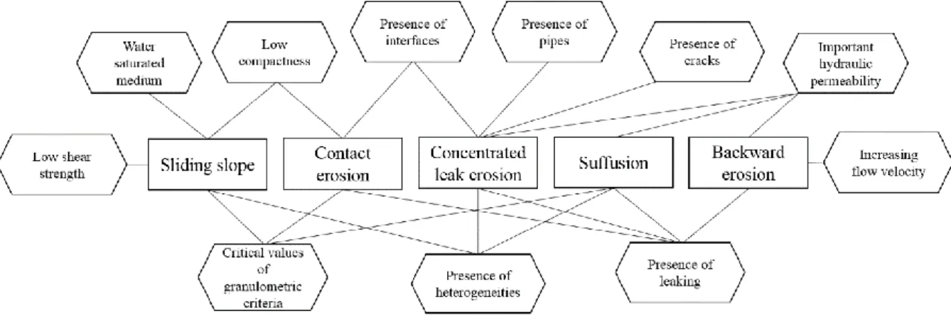
Links between pathologies and the mechanisms leading to the failure of an embankment dike To prevent the failure of an earthen levee system, it is required to take an interest in its physical properties and characteristics. Pathological physical properties of a levee can indeed be associated with several mechanisms leading to the breakage of an embankment (Figure 1). The different mechanisms considered are internal erosion mechanisms (suffusion, contact erosion, concentrated leak erosion and backward erosion) and sliding slope mechanisms.
Figure 1 Diagram displaying the links between pathologies (in hexagons) and mechanisms that may
Links between pathologies and mechanisms leading to the failure of an embankment (Figure 1) are not necessarily unidirectional. For example, a high hydraulic permeability value will be conducive to the development of suffusion but this internal erosion mechanism leads, in turn, to an increase in hydraulic permeability. Most of the soil physical properties within a levee shift to more extreme values as failure mechanisms develop, accelerating the modification of the levee characteristics.
A complex aspect of the levee rupture is that it can stem from more than one failure mechanism. Therefore, most of the time, several pathologies are involved in the process. For that reason, it is necessary to be able to link investigation methods to the soil physical properties they can estimate in order to characterize correctly a levee.
Example of levee investigation with a single geophysical method
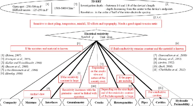
Electrical Resistivity Tomography (ERT) is a classical geophysical method for the investigations of levees. ERT appears to be a good example because it is sensitive to several physical properties and it is cost-effective (Kumar, 2012). On the same diagram (Figure 2), the methods features (acquisition rate, cost, investigation depth…) and its ability to assess levee physical properties are represented. Thicknesses of the lines are directly correlated to the high or low ability of ERT to define levee properties. Since the use of a method instead of another depends on limiting factors and environmental conditions, such limitations are represented in red and act as conditions to the characterization quality (for a specific property), with supporting references. Once a property is “correctly” estimated, and depending on its value or nature, it may be considered pathological and then associated to some failure mechanism (Figure 1). This diagram could only be conducted thanks to results based on various internal investigation campaign and bibliographic research.
Figure 2 Diagram highlighting the relations between the ERT method and the physical properties in a
levee under certain conditions and with supporting references.
The graphic representation for the ERT method (Figure 2) displays a large amount of information but still allows the end user to quickly understand the ability of ERT to assess one property instead of another, under specific conditions. In the field of levee investigation, there is a lack of overall vision on existing links, and their robustness, between investigation methods and soil physical properties. Generalizing the concept presented in Figure 2 would help to select relevant combinations of two or more particular methods for identifying a given property and under specific conditions.
Benefits of a new levee database structure
To answer the need of an overall vision on existing links between investigation methods, we propose a new structure for levee databases detailed in Figure 3. As part of flood embankments surveys, this database architecture enables to link soil physical properties (Figure 3E) within levees to geophysical and geotechnical measured or calculated outputs (Figure 3C). The links between pathologies and levee failure mechanisms (Figure 1) are also included in the database structure (Figure 3). The aim of this graphic representation is to emphasize the possible combinations between geophysical and geotechnical investigation methods (Figure 3A), with supporting references (Figure 3B and D).
On the one hand, this organized information can allow the user to revert to more conventional combinations of methods (e.g. combining ERT method with CPT drilling). On the other hand, taking some environmental conditions or limitations (Figure D, symbolized by red boxes) into account, less obvious combinations of methods can emerge. Indeed, users would be free to use search criteria depending on their aims (investigation depths, acquisition rate, costs, reliability of the method…) as well as the potentially limiting environmental conditions they are aware of (presence of power line, roots, metallic structures, topography, etc…). Hence, for a specific study, the most relevant combinations of methods would stand out with corresponding pertinence levels and bibliographic references.
Figure 3 Diagram displaying the database structure linking various geophysical and geotechnical
methods with soil physical properties and characteristics of levees. This is a generalization of figure 2. Conclusions
This work, based on references and rigorous methodology, presents a new structure for levee database using the example of the ERT method. The complete database structure should allow agencies and levee managers, under specific conditions, to select appropriate combinations of investigation methods to reliably estimate whether the values of one or more levee physical properties are pathological and whether this state brings out ongoing failure mechanisms. The graphic representation associated to the base structure enables a quickly understandable overview of most of the geophysical and geotechnical methods for levee investigation. With all the supporting references included, it can also be a useful tool for the research community, highlighting combinations of methods hardly ever done and opening new ways of reflections.
In the future, the database structure could be used as a participatory platform, allowing the research community to improve the data structure, including more knowledge with supporting references. In further studies, in order to constrain an embankment dike modelling, it should be pertinent to implement data fusion algorithms (e.g. Ploix et al., 2011) based on all types of information, including from visual inspection and sample analysis.
References
Abu-Hassanein, Z.S., Benson, C.H. and Blotz, L.R. [1996] Electrical resistivity of compacted clays. Journal of Geotechnical Engineering, 122, 397–406.
Archie, G.E. [1952] Classification of carbonate reservoir rocks and petrophysical considerations. Aapg Bulletin, 36, 278–298.
Beck, Y.L. [2008] Evaluation de l’état hydrique d’un sol fin par méthodes électriques et électromagnétiques: Application géotechnique, PhD Thesis, Ecole Centrale de Nantes.
Besson, A., Cousin, I., Dorigny, A., Dabas, M. and King, D. [2008] The temperature correction for the electrical resistivity measurements in undisturbed soil samples: Analysis of the existing conversion models and proposal of a new model. Soil Science, 173, 707–720.
Bièvre, G. [2007] Méthodes géophysiques pour la reconnaissance des digues des voies navigables. Centre d’Études Techniques Maritimes et Fluviales.
Chalikakis, K., Plagnes, V., Guerin, R., Valois, R. and Bosch, F.P. [2011] Contribution of geophysical methods to karst-system exploration: an overview. Hydrogeology Journal, 19, 1169–1180.
François, D., Mériaux, P. and Monnet, J. [2016] Méthodologie de reconnaissance et de diagnostic de l’érosion interne des ouvrages hydrauliques en remblai. Presses des Ponts : Publications IREX. Huntley, D. [1986] Relations between permeability and electrical resistivity in granular aquifers. Ground Water, 24, 466–474.
Karaoulis, M., Revil, A., Zhang, J. and Werkema, D.D. [2012] Time-lapse joint inversion of crosswell DC resistivity and seismic data: A numerical investigation. Geophysics, 77, D141–D157.
Kearey, P., Brooks, M. and Hill, I. [2013] An introduction to geophysical exploration. John Wiley & Sons.
Keller, G.V. and Frischknecht, F.C. [1966] Electrical methods in geophysical prospecting. Pergamon Press Inc.
Kumar, D. [2012] Efficacy of electrical resistivity tomography technique in mapping shallow subsurface anomaly. Journal of the Geological Society of India, 80, 304–307.
Mériaux, P., Tourment, R. and Wolff, M. [2005] Le patrimoine de digues de protection contre les inondations en France d’après la base de données nationale des ouvrages. Ingénieries-EAT, Special issue, 15–21.
Ploix, M.-A., Garnier, V., Breysse, D. and Moysan, J. [2011] NDE data fusion to improve the evaluation of concrete structures. NDT & E International, 44, 442–448.
Samouëlian, A., Cousin, I., Richard, G., Tabbagh, A. and Bruand, A. [2003] Electrical resistivity imaging for detecting soil cracking at the centimetric scale. Soil Science Society of America Journal, 67, 1319–1326.