HAL Id: hal-02937486
https://hal.archives-ouvertes.fr/hal-02937486
Submitted on 1 Nov 2020
HAL is a multi-disciplinary open access
archive for the deposit and dissemination of sci-entific research documents, whether they are pub-lished or not. The documents may come from teaching and research institutions in France or
L’archive ouverte pluridisciplinaire HAL, est destinée au dépôt et à la diffusion de documents scientifiques de niveau recherche, publiés ou non, émanant des établissements d’enseignement et de recherche français ou étrangers, des laboratoires
Early to late Holocene vegetation and fire dynamics at
the treeline in the Maritime Alps
Walter Finsinger, Quentin Vanel, Adriano Ribolini, Willy Tinner
To cite this version:
Walter Finsinger, Quentin Vanel, Adriano Ribolini, Willy Tinner. Early to late Holocene vegetation and fire dynamics at the treeline in the Maritime Alps. Vegetation History and Archaeobotany, Springer Verlag, 2020, �10.1007/s00334-020-00795-x�. �hal-02937486�
##########################################################################################
1
The authors do not recommend the distribution of this version of this article.
2
The article is freely available upon request.
3
To receive a copy, please send a request to Walter Finsinger at:
4
walter.finsinger@umontpellier.fr
5
##########################################################################################6
7
Early-to-late-Holocene vegetation and fire dynamics at the treeline in the
8
Maritime Alps
9
Published in Vegetation History and Archaeobotany (2020)
10
11
Walter Finsinger
1*, Quentin Vanel
2, Adriano Ribolini
3, Willy Tinner
412
13
1 – ISEM, University of Montpellier, CNRS, EPHE, IRD, Montpellier, France
14
2 – Ecosphère, Agence Nord-Ouest, 28 rue du Moulin, 60490 Cuvilly, France
15
3 – Dipartimento di Scienze della Terra, Universitá di Pisa, Pisa, Italy
16
4 – Oeschger Centre for Climate Change Research and Institute of Plant Sciences, University of Bern,
17
Altenbergrain 21, CH-3013 Bern, Switzerland
18
*Correspondence and requests should be addressed to: Walter.Finsinger@umontpellier.fr, +33 (0)6 69 61 07 42
19
20
Abstract
21
We used pollen, plant-macrofossil, and charcoal records to unfold local long-term timberline shifts and changes
22
in vegetation composition in relation to fire activity at the modern upper forest limit (ca. 2000 m asl) in the Mont
23
Bégo area. The area is an iconic place for Alpine archaeology because it bears thousands rock-art engravings
24
whose age cannot be directly assessed. Our new record confirms the occurrence of distinct land-use phases
25
(7450-7150, 6200-4900, and 4250-3700 cal BP), as suggested by prior studies based on rock-art typology.
26
Moreover, the macrofossil-inferred vegetation reconstruction (co-dominance of Pinus and Betula) suggests that
27
early-Holocene conditions were moister than in dry inner-alpine valleys, where Larix decidua played a more
28
important role, both in past as well as in modern timberline forests. After 8000 cal BP, the timberline shifted to
29
higher elevation and mixed Abies alba and Pinus cembra stands established around the study site. These
fire-30
sensitive tree populations were definitely replaced during the Bronze Age (around 4000 cal BP) by L. decidua
31
that still dominates the subalpine forests in the area today. Our study supports the notion that while the range (or
32
realized climatic niche) of A. alba has been reduced at the colder-end of its natural distribution that of L. decidua
33
has been widened by land-use changes and fire disturbances to create high-alpine pasture woodlands.
34
35
Keywords: Vegetation dynamics; mountain ecosystems; treeline ecotone; land-use phases; pasture woodlands; fires
36
Introduction
38
The altitudinal treeline ecotone is a prominent ecosystem boundary in mountain landscapes (Arno and Hammerly
39
1984) at the transition between the upper limit of closed forests (timberline, i.e. the upper limit of subalpine forests)
40
and open alpine meadows (beyond the upper tree species limit) (Körner 2003). While the species composition of the
41
treeline ecotone and of subalpine forests is mainly influenced by water availability, rainfall, soils, and disturbances
42
(Henne et al. 2011; Schwörer et al. 2014a), the upper limit of tree growth is primarily determined by temperature at
43
the regional scale (Körner and Paulsen 2004; Holtmeier and Broll 2005; Holtmeier 2009). Therefore, climatic
44
changes are expected to lead to both altitudinal shifts in its position and changes in species composition (Walther et
45
al. 2005; Heiri et al. 2006). However, in addition to being influenced by these factors, both the position and
46
composition of the timberline and of subalpine forests can be substantially modified by land use (Arno and
47
Hammerly 1984). In the European Alps, with its long history of land-use (Millennium Ecosystem Assessment 2005),
48
subalpine forests and treeline ecotones have been used and exploited for millennia to create pastures and grazing
49
meadows, often with the use of fire (Tinner 2007).
50
Palaeoecology provides long-term records of changes in timberline position and composition (Tinner 2007), and into
51
past trends of fire activity (Conedera et al. 2009). Such proxy-based reconstructions are relevant for estimating
52
vegetation responses to changing environmental conditions and land-use changes (Tinner 2007), thereby unfolding
53
cultural legacies on forested landscapes that are often viewed as ‘ancient’ (Willis and Birks 2006; Feurdean et al.
54
2009). As a result, a growing number of studies have focussed on long-term treeline dynamics in the European Alps
55
(e.g. Lang and Tobolski 1985; Tinner et al. 1996; Wick and Tinner 1997; Wick et al. 2003; Tinner and Kaltenrieder
56
2005; Lotter et al. 2006; Finsinger and Tinner 2007; Blarquez et al. 2010; Berthel et al. 2011; Rey et al. 2013;
57
Schwörer et al. 2014b) and elsewhere (e.g. Herring et al. 2018; Orbán et al. 2018; Finsinger et al. 2018).
58
In this study, we focus on treeline vegetation and fire dynamics from the Vallée des Merveilles and Mont Bégo
59
(2872 m asl) area, an iconic area in the Argentera Massif better known for the 36,000 rock arts distributed among c.
60
4200 rocks between 2000 and 2700 m asl that were already described in the 16th century (Arcà 2018) and more
61
intensely studied since the end of the 19th century (Bicknell 1913; Conti 1940, 1972; de Lumley 1984, 1995).
62
Recently, a chronological framework of land-occupation and land-abandonment phases has been proposed (Binder
63
et al. 2009; Huet 2017). .However, because rock engravings could not be dated directly (they lack calcite crusts or
64
organic material), their ages were estimated based on rock-art typology, data from archaeological excavations and
65
surveys (Conti 1940; Louis and Ségui 1949; de Lumley 1995; Machu et al. 2007; Huet 2012), and evidence from
66
pollen records (increases of herb pollen such as Artemisia, Chenopodiaceae and Poaceae) (de Beaulieu 1977;
67
Kharbouch 2000). Moreover, with the exception of pollen from crops and adventive weeds, increases of herb pollen
68
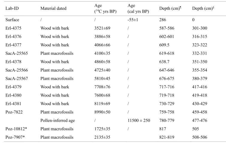
in high-elevation lake sediments may also be indicative of climate-induced treeline shifts to lower elevations (Heiri
69
et al. 2006). In addition, fires can have a significant and long-lasting impact on vegetation structure and composition
70
by promoting open spaces and fire-resistant species, and disfavouring fire-sensitive species (Stähli et al. 2006; Leys
71
et al. 2014; Schwörer et al. 2015).
72
New taxonomically highly resolved palaeoecological records that include both plant macrofossils and charcoal
73
records may substantially improve knowledge on local vegetation and fire dynamics at the treeline ecotone in the
74
study area, thereby providing a better link between long-term vegetation dynamics, changing environmental
75
conditions, and findings of archaeological artefacts, rock engravings, and land-use phases. Both charcoal and
plant-76
macrofossil records may be relevant proxies in this study area, for at least three reasons. Firstly, in mountain settings
77
the combination of plant-macrofossil and charcoal records can allow apprehending past vegetation dynamics and
78
vegetation responses to changing environmental conditions and fire disturbances better than with wind-dispersed
79
pollen (Birks and Birks 2000). Secondly, pollen records (de Beaulieu 1977; Kharbouch 2000; Finsinger 2001; Ortu
80
et al. 2003) suggest that fire-sensitive Abies alba populations (Tinner et al. 1999) were more abundant during the
81
mid Holocene in the region. However, it is unclear at which elevation populations of this temperate tree species were
82
able to dominate, and how these populations responded to changing environmental conditions and disturbances
83
(including fires). Thirdly, the modern timberline is dominated by Larix decidua (Ozenda 1950; Barbero et al. 1973),
84
which is heavily under-represented in pollen records (Sjögren et al. 2008) but much better represented in
plant-85
macrofossil records because it sheds its needles in high numbers every year (Tinner and Theurillat 2003).
86
We selected as study site the Lac des Grenouilles (1994 m asl), which is located at about the modern timberline
87
(c. 2000 m asl; Ozenda 1950) and below the modern potential treeline in the Mont Bégo rock-art area (Fig. 1a).
88
Littoral sediments from this lake already have been analysed for pollen (Kharbouch 2000). However, that
89
sediment sequence was fragmentary (with hiatuses), and no plant-macrofossil and charcoal analyses were
90
conducted. Here we present novel temporally and taxonomically highly resolved pollen, spore, stomata,
plant-91
macrofossil, and charcoal records from sediments collected from the lake centre. Due to its small size (0.015
92
km2), the lake should collect sufficient plant macrofossils, thereby allowing the reconstruction of past vegetation
93
dynamics in the close surroundings. Because we were particularly interested in characterizing local-scale
94
changes in fire activity and vegetation dynamics prior to and during prehistoric land-use phases (7350-3700 cal
95
BP), we performed high-resolution macroscopic charcoal and plant-macrofossil analyses for early-to-late
96
Holocene sediments (Mesolithic - Early Bronze Age) sediments (10,000-3400 cal BP). In addition, we conducted
97
high-resolution palynological analyses for Neolithic to Early-Bronze Age sediments to investigate fire-vegetation
98
relationships using time-series analyses (Green 1981; Schwörer et al. 2014b).
99
100
101
Materials and Methods
102
Study area
103
Lac des Grenouilles (44°05’53” N, 7°29’07” E; 1994 m asl) is situated on the south-facing slope of the
104
Argentera Massif (Maritime Alps, southwestern Alps; Figure 1a) at the lower end of a hanging valley. Two small
105
seasonal streams feed the lake, and one outflow drains into the Vallon de Fontanalba, a tributary of the Vallon de
106
Casterino (Roya River basin). At the southeastern end of the Vallon is Mont Bégo, which separates that valley
107
from the Vallée des Merveilles. The majority of rock engravings is centred in the Vallée des Merveilles as well as
108
in the upper part of the Vallon de Fontalba (Figure 1a; Huet, 2017). Bedrock in the Mont Bégo area is dominated
109
by Permian granitoid and metamorphic rocks (Malaroda et al. 1970). However, Triassic-Jurassic calcareous and
110
dolomitic rocks and Grauwackes occur on the northern slope of the hanging valley (Faure-Muret 1967).
111
The study area lies at the edge of the inner-alpine zone (Figure 1b), which is characterised by higher
112
continentality (higher temperature seasonality and less rainfall) than the outer and intermediate
113
(“Zwischenalpen”) zones (Ozenda 2002; Landolt 2003). Sub-alpine forests in the inner-alpine zone are
114
dominated by Pinus cembra, L. decidua, and Pinus sylvestris (Ozenda 1985, 2002; Landolt 2003). In the Mont
115
Bégo area, the treeline ecotone and the subalpine forests are dominated by open L. decidua pasture woodlands
116
with minor shares of P. cembra, P. uncinata, and P. sylvestris, and Juniperus communis and Ericaceae shrubs
117
(Rhododendron hirsutum, and Vaccinium myrthillus) characterize the forest understorey. While the timberline is
118
located at c. 2000 m asl, isolated L. decidua and P. cembra tree stands can be found up to c. 2300 and individual
119
trees (> c. 2m) up to 2400 m asl (Ozenda 1950; de Beaulieu 1977, own observations). On the northern, more
120
humid, slope of the Massif, the timberline is generally substantially lower (c. 1700 m asl) and Fagus sylvatica is
121
more abundant than on the southern slopes (Ozenda 1950). In the area trees can be found up to c. 2300-2400 m
122
asl (Barbero et al. 1973). A. alba-dominated forest stands occur few kilometres to the south of the study site
123
(Ponel et al. 2001) at altitudes of c. 900 to 1600 m asl (Barbero and Bono 1970), i.e. c. 400 m below the study
124
site at current timberline and c. 800 m below treeline. At Lac des Grenouilles, mean monthly temperatures are
125
around -2°C in winter, and 13°C in summer. The mean annual precipitation is about 1000 mm. Monthly rainfall
126
shows the influence of the Mediterranean climate with a bimodal distribution (maxima in spring and autumn
127
with c. 100-115 mm month-1) and a comparatively drier summer (c. 50 mm month-1) (Fick and Hijmans 2017).
128
129
Fieldwork and sediment-core correlation
130
A geomorphological survey was undertaken in the area around Lac des Grenouilles. The survey was particularly
131
focussed on glacial and periglacial landforms (Figure 1c). Two overlapping sediment cores (Gren-2 and Gren-3)
132
were collected in the year 2001 in 1-m long drives from a floating platform in the lake’s centre with a modified
133
Livingstone piston cover (Merkt and Streif 1970) at 286 cm water depth. Core Gren-2 was collected with a
134
smaller-diameter barrel (5 cm) than core Gren-3 (8 cm). Sediment-core drives were longitudinally cut into halves
135
using an electro-osmotic guillotine (Sturm and Matter 1972), and photographed with a digital camera and
136
artificial-light equipment at the Institute of Plant Sciences (University of Bern). We subsequently used the
137
changes in lithology to correlate the sediment cores (Figure 2) and establish core depths for the 615 cm long
138
master core.139
140
Chronology141
The depth-age model is constrained by the following control points: the estimated age of the surface sediments
142
(c. the year of coring), 13 AMS radiocarbon (14C) dates extracted from core Gren-3 from terrestrial plant remains
143
(Finsinger et al. 2019), and a pollen-inferred age set to constrain the Younger Dryas/Holocene boundary
144
(following Giesecke et al. 2014) (Table 1). The two lowermost 14C dates were rejected because they provided
145
unrealistically young ages in comparison to all other age determinations, including regional biostratigraphy.
146
Radiocarbon ages were calibrated to calendar ages using the IntCal13 data set (Reimer et al. 2013) prior to fitting
147
a smoothing spline (Figure 2) using the CLAM v2.2 software (Blaauw 2010). Distinct turbidite layers, most
148
likely representing sediment deposition that occurred over a very short time span (hours, days), were excluded
149
from the depth-age model (Figure 2), following Heiri et al. (2003). Therefore, except where otherwise mentioned
150
all references to sediment depth hereafter refer to a corrected sediment depth that excludes turbidites.
151
152
Pollen, spores, plant-macrofossils, and charcoal analyses
153
Sediment samples (volume: 1 cm3; thickness: 1 cm) for pollen analysis were treated with standard physical and
154
chemical treatments (incl. HCl, KOH, sieving with a 500-μm mesh and decanting, HF, and Acetolsyis), coloured
155
with Fuchsin, and mounted in glycerine jelly. Pollen and spores were identified and counted using pollen keys
156
(Punt et al. 1976; Reille 1992; Moore et al. 1998) and the reference collection at the Institute of Plant Sciences
157
(University of Bern). Stomata were identified based on Trautmann (1953) and Finsinger and Tinner (2020) and
158
dung-fungi Sporormiella spores were identified based on Davis (1987). Results are presented as percentages of
159
the terrestrial pollen sum, which includes pollen from trees, shrubs, and herbs (spores and pollen of aquatic
160
plants were excluded; Figures 3a and 4). Sampling resolution was increased to one sample each 1-4 cm in the
161
portions between 298-387 cm and 392-450 cm depth. Pollen can be dispersed by wind over large distances and
162
generally integrates vegetation at extra-local to landscape scales (Sugita 1994). While the small area of the site
163
(0.015 km2) might suggest that the pollen source area could be substantially smaller (e.g. several hundred meters
164
to a few kilometres at most; Sugita 1994; Conedera et al. 2006), landscape-scale pollen from lower-elevation
165
areas may reach the site, which is located in an area with steep topography (Finsinger et al. 2007). By contrast,
166
stomata and Sporormiella spores should be considered local-scale indicators of the presence of the parent trees
167
(Ammann et al. 2014) and large herbivore density (Baker et al. 2013; Gill et al. 2013), respectively.
168
For plant macrofossils, sampling was mostly continuous between 284 and 460 cm depth. We measured sample
169
volume by water displacement (volumes vary between 12 cm3 and 19.25 cm3; median: 16 cm3). Samples were
170
soaked in a 10% NaP2O4 solution for 24 hours and sieved with water through a 250-µm mesh. Identification of
171
plant macrofossils was performed under a dissecting microscope (7.5X) and achieved by comparisons with
172
reference collections stored at the Institute of Plant Sciences (University of Bern), at the University of
173
Montpellier, and atlases (Cappers et al., 2006; Schoch et al., 1988; Tomlinson, 1985). To account for varying
174
sample volumes, the results are presented as concentrations calculated with respect to a standard sediment
175
volume of 10 cm3 (Figure 3b). Plant macrofossils were grouped and summed by genus to compare them with the
176
pollen percentage records (Figures 3b and 4). Plant macrofossils are dispersed over substantially shorter
177
distances than pollen, and therefore better reflect local-scale vegetation within some decametres around the site
178
(Birks and Birks 2000; Birks and Bjune 2010).
179
For macroscopic charcoal analysis, contiguous samples (volume: 1 cm3; thickness: 1 cm) were taken between
180
283 and 460 cm depth. Samples were first soaked in a 10% NaP2O4 solution for 24 hours and then gently washed
181
through a 160-µm mesh using a manual water spray. The remaining particles were subsequently bleached in a
182
2.6% NaOCl solution for a few minutes to distinguish charcoal from dark organic matter, following Genries et
183
al. (2012). The number and area of charcoal fragments were estimated under a dissecting microscope (at a
184
magnification of x6.3) connected to a digital camera and using image analysis software (Winseedle pro v.2007).
185
Charcoal concentrations (both as total number and area per sample) were converted to charcoal-accumulation
186
rates (hereafter denoted as CHAR) to account for variations in sedimentation rate (Whitlock and Larsen 2001).
187
Calibration studies suggest that charcoal particles larger than 600 µm might be of local origin, while smaller
188
particles can easily be dispersed over large distances (up to 30-50 km; Oris et al. 2014; Adolf et al. 2018).
189
Therefore, the low-frequency trends of the macroscopic charcoal record can be attributed to overall
landscape-190
scale fire activity (Marlon et al. 2008; Adolf et al. 2018). We estimated the low-frequency trend by fitting loess
191
smoothing (Cleveland and Devlin 1988) to the macrocharcoal influx values (Figure 4).
192
Pollen-assemblage zones were determined by optimal partitioning with square-root transformed percentage
193
values for pollen types included in the pollen sum (Birks and Gordon 1985). Statistically significant zones
194
(continuous lines in Figure 3) were assessed by comparison with the broken-stick model, following Bennett
195
(1996). Zonation was performed with Psimpoll v4.26 (Bennett 2008). The programs Tilia v2.6.1 and Affinity
196
Designer v1.7.0 were used to plot the pollen and plant-macrofossil diagrams (Figure 3).
197
198
Time-series analyses
199
To investigate leads and lags between fire activity (charcoal influx) and vegetation (pollen percentages), we use
200
cross-correlation analyses (Green 1981; Tinner et al. 1999; Rey et al. 2019). Analyses were restricted to the
201
higher-resolution section between 387 and 298 cm depth (6950-3750 cal yr BP) where the median sampling
202
resolution is of 48.5 years between samples (n. of samples: 49) and the median absolute deviation is 26.7 years
203
(Figure S1). This analysis requires homogeneously spaced time series sampled at the same time resolution
204
(Venables and Ripley 2002). Thus, we fitted a loess-smoothed line (span=0.15) to estimate pollen percentage
205
and charcoal influx values at 100-year intervals (Figure 4). Cross-correlation analyses were performed under the
206
R computing environment (R Core Team 2017). Cross-correlation coefficients are presented for maximum lags
207
of ±4 corresponding to ±400 years (Figure 5). As in our time series the loess-smoothed values are not entirely
208
independent, the 95% confidence intervals must be viewed with caution (Venables and Ripley 2002, p. 390).
209
210
211
Results and interpretation
212
213
Geomorphological context
214
Lac des Grenouilles is dammed by a prominent lateral moraine mantling the left flank of the Vallon de
215
Fontanalba (Figure 1c). According to regional reconstructions (Cossart 2008; Federici et al. 2012, 2017; Cossart
216
et al. 2012), the moraine formed during the Last Glacial Maximum (LGM) and the moraines mapped further
217
upvalley (around 2200-2300 m asl) were probably deposited during the Younger Dryas cold event (Egesen
218
stadial), as observed on the northern side of the Maritime Alps (Spagnolo and Ribolini 2019). The sparse glacial
219
debris in the area of Lac Ste Marie suggests the presence of relict ice bodies or glacierets also during the
220
Holocene cold events. Part of this debris, which is locally mixed with rock falls, experienced the formation of
221
permafrost. Permafrost creeping led to the formation of a rock glacier located around 2400 m asl. According to
222
permafrost-monitoring data in the Maritime Alps (Ribolini and Fabre 2006; Ribolini et al. 2007, 2010),
223
permafrost in the rock glacier could be still present.
224
225
Vegetation and fire histories
226
Three statistically significant pollen-assemblage zone boundaries were determined (Figure 3a). The zone at the
227
bottom (Gren-1; >467 cm; >10,700 cal BP) probably corresponds to the late-Glacial and early-Holocene because
228
pollen assemblages reflect a well-established pattern of late-Glacial pollen stratigraphies from the study area (de
229
Beaulieu 1977; de Beaulieu et al. 1994; Finsinger and Ribolini 2001). This chronological attribution is consistent
230
with the geomorphological context, with an LGM moraine that dammed Lac des Grenouilles. Pinus, Artemisia,
231
and Poaceae dominate pollen assemblages below 490 cm depth, with minor abundances of Betula, deciduous
232
Quercus, and Juniperus pollen. Around 12,000 cal BP, abundances of Artemisia and Ephedra pollen are higher
233
than in prior samples, and Pinus pollen abundance is lower, suggesting an opening of the vegetation that may
234
reflect the effects of the Younger Dryas cooling (12,850-11,650 cal yr BP; Rasmussen et al. 2014) in the Alpine
235
region (Larocque and Finsinger 2008; Samartin et al. 2012). Plant macrofossils (Figures 3b and 4) indicate that
236
Larix was present in the surroundings shortly prior to the onset of the Younger Dryas, and that Dryas octopetala
237
carpets briefly expanded at the Younger Dryas/Holocene transition. Sporormiella dung-fungi spores were
238
regularly found, suggesting the presence of large herbivores near the lake during the late Glacial. A shift to closer
239
vegetation with higher abundance of Betula, increasing arboreal pollen, a decrease of Artemisia and herb pollen,
240
and the first appearance of Tilia pollen characterizes the transition to the warmer Holocene.
241
The transition to zone Gren-2 (467-397 cm; 10,700-7450 cal BP) is marked by the rise of Quercus pollen
242
abundance, and the first appearance of Corylus, Fraxinus, Alnus glutinosa, and Acer pollen indicating that
243
thermophilous tree populations expanded, probably at lower elevation. The continuous presence of Betula
244
macrofossils and the rare occurrences of Pinus mugo and Juniperus needles suggest that the site was at the
245
treeline ecotone and that open Betula-Pinus stands were located in the surroundings. Rare occurrences of Alnus
246
viridis pollen and the absence of its macrofossils suggest that populations were either very sparse or distant. In
247
spite of decreasing Pinus pollen abundance, arboreal pollen abundance is highest (ca. 75-90%) in this zone. As
248
observed in other records (Tinner and Hu 2003; Finsinger et al. 2014), the two charcoal-influx records (by counts
249
and by area) are highly redundant (r=0.912, p-value<0.001; Figure S2). Thus, only the charcoal-influx record by
250
count is used in the following discussion. Fire activity was overall low (CHAR values <0.1 pieces cm-1 year-1;
251
Figure 4).
252
Increasing abundance of Abies pollen and abundant finds of its plant-macrofossils in zone Gren-3 (397-330.5
253
cm; 7450-4700 cal BP) indicate the rise of the timberline and the establishment and expansion of a subalpine
254
forest in the surroundings. While light-demanding Betula populations shrank as shown by decreasing pollen and
255
macrofossil abundance, increasing pollen abundance and needle finds indicate that P. cembra populations
256
expanded. Pollen and plant macrofossil abundances of light-demanding Larix were low until c. 6000 cal BP,
257
when Larix populations started to expand. Increasing herb pollen abundance and charcoal influx values (CHAR
258
values >0.1 pieces cm-1 year-1) suggest that forest cover decreased due to rising fire activity. Fire-sensitive Abies
259
populations, however, collapsed some 500 years later when a further rise in fire activity occurred.
260
Simultaneously, Larix populations further expanded and Betula pollen increased, indicating a major shift in the
261
composition of the subalpine forest cover. Between 4800 and 4300 cal BP (around transition into zone Gren-4:
262
330.5-220 cm; 4700-2000 cal BP) high arboreal pollen percentages suggest the partial recovery of forest cover
263
during a c. 500-years long period of low fire activity. Regular findings of plant macrofossils indicate that mixed
264
Abies populations re-expanded in the subalpine forest around the site. Around 4300 cal BP, fire activity increased
265
again and the composition of the subalpine forest shifted to a Larix-dominated forest. Decreasing Betula pollen
266
abundance and absence of plant macrofossils suggest that Betula stands, perhaps above the timberline, were
267
strongly reduced. Abies alba and Pinus cembra plant macrofossil abundances strongly decrease after 4300 cal
268
BP, pointing to local extinctions of the two species.
269
Variations in the relative abundance of cultural indicator pollen from crops and weeds as well as Sporormiella
270
dung-fungi spores document transient phases of human pressure. We found moderately higher values of
271
Artemisia and Urtica pollen, and of Sporormiella spores around 7450-7150 cal BP. Sporormiella spores’
272
abundance shows a local maximum around 6200-5500 cal BP, together with an increase of Poaceae and Rumex
273
pollen and the regular occurrence of Cerealia-type and Plantago lanceolata-type pollen. Similarly, Poaceae,
274
Rumex, Veratrum, Trifolium pratense-type, and P. lanceolata-type pollen, and Sporormiella spores abundance
275
increase after 4300 cal BP. In all of these three phases, arboreal pollen percentages are substantially reduced,
276
indicating transient openings of the subalpine forests in response to prehistoric land-use activities.
277
278
Time series analyses
279
Pollen percentages of herb pollen have significant positive correlations with charcoal influx (maximum
280
correlation at lag 0; Figure 5). The Poaceae illustrate particularly well the expansion of grasslands as a
281
consequence of forest-cover reduction in response to increasing fire activity, as also observed in other studies
282
(Rey et al. 2013, 2019). However, positive correlations of cultural indicators (P. lanceolata and Urtica) are
283
delayed, suggesting a gradual intensification of land use after fires, as also observed in another record from the
284
Alps (Gobet et al. 2003). By contrast, Sporormiella shows positive correlations at negative lags, suggesting that
285
grazing by large herbivores preceded increases in fire activity.
286
Most tree taxa (Abies, Betula, and Pinus) show negative correlations with charcoal influx. Abies is negatively
287
correlated at positive lags, suggesting either a slightly higher fire tolerance or less intense disturbance, if
288
compared to warmer lowland sites (Tinner et al. 2000), a finding that is in agreement with other high-resolution
289
mountain studies (Rey et al. 2013; Schwörer et al. 2015). Similarly, Pinus is negatively correlated at positive
290
lags. While this matches with the long-term fire ecology of P. cembra, a tree sensitive to prolonged fire
291
disturbance (Gobet et al. 2003; Schwörer et al. 2015), the clear interpretation of this result is complex because
292
the plant-macrofossil record shows the local presence of Pinus mugo (Gobet et al. 2003; Stähli et al. 2006;
293
Finsinger et al. 2018). Moreover, the contribution of pollen from other Pinus species growing at lower elevation
294
is difficult to estimate. Betula and shrubs are also negatively correlated, but at negative lags. By contrast, Larix is
295
positively correlated at positive lags, suggesting the gradual and delayed expansion of larch-dominated open
296
woodlands. While this contrasts with results from the Engadin, which showed non-lagged negative correlations
297
(Gobet et al. 2003), our results are consistent with evidence of Larix’ fast post-fire regeneration (Schöneberger
298
and Wasem 1997; Malowerschnig and Sass 2014).
299
300
301
Discussion302
Influence of climate on early-Holocene afforestation
303
The late Glacial (c. 14,600-11,650 cal BP) vegetation was dominated by grasslands with Artemisia and Poaceae
304
(de Beaulieu 1977; this study), and Pinus probably occurred at lower elevation (de Beaulieu 1977). The absence
305
of Betula plant macrofossils suggests that these trees were either very sparse (de Beaulieu 1977) or locally
306
absent. The findings of L. decidua needles and pollen indicate the presence of this conifer tree in the
307
surroundings prior to the Younger Dryas. This corroborates the very rare findings of Larix pollen grains in late
308
Glacial sediments at Selle di Carnino (de Beaulieu 1977), a peaty depression at 1900 m asl few kilometres to the
309
east from Lac des Grenouilles. These two sites are among the highest-elevation Alpine sites where tree pollen,
310
stomata, and macrofossils suggest tree growth during the Bølling/Allerød (c. 14,600-12,800 cal BP) (Wagner et
311
al. 2015). For instance, the stomata findings of Juniperus, Larix, and Pinus at Simplon-Alter Spittel (1885 m asl)
312
a south-facing site in the Divedro Valley (southern Swiss Alps) showed the early establishment of trees during
313
the Allerød (13,900–12,800 cal. BP) (Welten 1982; Ammann et al. 2014). The substantial drop in summer
314
temperatures during the Younger Dryas cooling in the Alpine region (Heiri et al. 2014) likely led to a treeline
315
depression below Lac des Grenouilles, as no tree macrofossils were found. In other records form the Alpine
316
region treeline depressions of ca. 300-400 m were recorded (Tinner and Vescovi 2005; Gobet et al. 2005). Given
317
that sedimentation was not interrupted at Lac des Grenouilles, the Younger Dryas glacier advance did not reach
318
the site. This is in agreement with geomorphological evidences that suggest the location of Younger Dryas
319
moraines mostly above 2100 m asl (Brisset et al. 2015; Spagnolo and Ribolini 2019).
320
The plant-macrofossil record supports prior interpretations (de Beaulieu 1977; Ponel et al. 2001) suggesting that
321
treeline was close to 2000 m asl during the early Holocene in the study area. Specifically, an open Betula and
322
Pinus (probably P. mugo) dominated treeline with scattered Juniperus shrubs re-expanded around Lac des
323
Grenouilles in the early Holocene until c. 8000 cal BP, when the first Abies macrofossil was found. However,
324
due to the lack of 14C dates around the Younger Dryas/Holocene transition (Fig. 2), it is difficult to establish
325
precisely the afforestation lag in response to the early-Holocene warming for Lac des Grenouilles.
Pollen-326
independent temperature reconstructions show rapid warming of c. 2-4ºC within a few decades after the Younger
327
Dryas (Lotter et al. 2000; Schwander et al. 2000; von Grafenstein et al. 2000; Larocque and Finsinger 2008;
328
Heiri et al. 2015) that likely led to a rapid early-Holocene treeline rise in the Central and Southern Alps, showing
329
the ability of treelines in tracking climate warming with decadal to centennial lags (Tinner and Kaltenrieder
330
2005). Conversely, other sites suggest that due to the regional setting (e.g. colder Northern Alps) or local
331
peculiarities (soils, aspect, moisture availability), today’s treeline positions were only reached at ca. 10,000 cal
332
BP (Schwörer et al. 2014a) or even after 8200 cal BP (Finsinger and Tinner 2007). Nevertheless, we found a
333
short-term early-Holocene expansion of Dryas octopetala, a pioneer species of open, base-rich habitats
334
(Elkington 1971), prior to the expansion of Betula at 11,300 cal BP. This indirectly supports the chronology for
335
Lac des Grenouilles, because early-Holocene expansions of D. octopetala were also detected at Gouillé Rion and
336
at Lac de Fully, two sites above current timberline in the dry inner-alpine Valais (Kaltenrieder et al. 2005b;
337
Finsinger and Tinner 2007) as well as at Iffigsee and Lago Basso (Wick and Tinner 1997; Schwörer et al.
338
2014b).
339
Early-Holocene fire activity was substantially lower than during the mid-to-late-Holocene (Figure 4). We assume
340
that fire activity was limited by low biomass availability, as also observed elsewhere (Berthel et al. 2011;
Gil-341
Romera et al. 2014; Finsinger et al. 2018). Indeed, high early-Holocene insolation seasonality (Figure 4) likely
342
was a determining factor for climate-induced low biomass availability in high-elevation Alpine landscapes
343
(Schwörer et al. 2014a).
344
The absence of Larix during the early and mid Holocene at Lac des Grenouilles is striking when compared to
345
records from dry inner-alpine valleys. For instance, at Gouillé Rion Salix and D. octopetala tundra preceded the
346
expansion of a Larix-dominated subalpine forest around 11,000 cal BP (Tinner and Kaltenrieder 2005).
347
Similarly, an early-Holocene expansion of Larix has also been recorded at Lac de Fully, another site in the dry
348
inner-alpine Valais (Finsinger and Tinner 2007), at Iffigsee in the northern Swiss Alps (Schwörer et al. 2014b), at
349
Lej da San Murezzan in the Engadine and several other sites of the Swiss Alps (Gobet et al. 2005) as well as at
350
Lac du Loup in the inner-alpine sector of the French Alps (Blarquez et al. 2010) (Figure 1b). Indeed,
light-351
demanding Larix decidua grows at present mostly in continental climates, with cold, dry, and snowy winters (Da
352
Ronch et al. 2016), whereas Betula pendula and B. pubescens have greater tolerance to lower temperatures of the
353
coldest month, and B. pubescens has greater tolerance to higher annual precipitation (Beck et al. 2016). Thus, the
354
dominance of Betula in conjunction with the absence of Larix points to contrasting early-Holocene moisture
355
conditions in the Maritime Alps compared with the central Alps. The importance of moisture conditions was also
356
acknowledged when comparing past plant distributions from the currently moister northern Swiss Alps and the
357
currently drier inner-alpine valleys (Lotter et al. 2006; Schwörer et al. 2014b) and may explain the
early-358
Holocene dominance of Betula in the Scandes Mountains despite the presence of Larix sibirica (Kullman and
359
Öberg 2015).
360
361
Highest timberline position during the Holocene
362
At Lac des Grenouilles, Betula dominated the treeline ecotone with scattered Pinus stands (probably P. mugo as
363
suggested by the plant macrofossils) and Juniperus shrubs until ca. 8000 cal BP, when Abies expanded. The
364
timing of the Abies expansion is in good agreement with regional pollen data (de Beaulieu et al. 1994; Nakagawa
365
1998; Finsinger 2001). The dominance of temperate Abies at today’s treeline elevation marks the highest
366
timberline position, which was reached around 7500-7000 cal BP. While the stacked Alpine temperature
367
reconstruction shows highest temperatures around 8500-8000 cal BP, this interpretation is in good agreement
368
with a chironomid-inferred temperature record from the Alps (Heiri et al. 2003) and from the northern the
369
northern Apennines (Samartin et al. 2017) as well as with Global Circulation Models (Renssen et al. 2009), all
370
showing ~1.5 ºC higher-than-present temperatures during the Holocene Thermal Maximum (HTM) around 7500
371
cal BP. Some records also point to the establishment of progressively more oceanic conditions after 8000 cal BP
372
(Magny et al. 2011). Although the local establishment of Abies was suggested by the marked rise of pollen
373
percentages (Ponel et al. 2001), no Abies macrofossils were found in the nearby located Lac Long Inférieur at
374
2090 m asl (F. Damblon unpublished, see Finsinger 2001). This may suggest that Abies reached its upper limit at
375
about 2000-2100 m asl during the HTM in the study area. However, compared to other Alpine records, 2100 m
376
asl is a substantially lower mid-Holocene timberline elevation. Plant-macrofossil records document timberline c.
377
150-200 m above current timberline during the HTM to reach altitudes between c. 2300 and 2500 m asl (Tinner
378
and Theurillat 2003; Schwörer et al. 2014b). Thus, further plant-macrofossil records from sites at higher
379
elevation may be needed to constrain the position reached by the upper limits of the timberline and the treeline in
380
the study area during the Holocene.
381
The occurrence of mid-Holocene plant-macrofossil assemblages with both A. alba and P. cembra is striking
382
because at present these two species thrive together in very few and isolated locations, mainly in the inner-alpine
383
zone of the southwestern Alps. For instance, in the Valais (Switzerland) on steep and convex slopes around
1900-384
2000 m asl (Lingg 1986), in the Susa Valley (Italy) at c. 1950 m asl (Dotta and Motta 2000) and in the
385
Maurienne Valley (France) at 1950-2000 m asl (Chauchard et al. 2010) A. alba occurs together with P. cembra,
386
P. abies, and L. decidua, and further east in the inner-alpine Italian Vinschgau Valley it occurs with P. cembra
387
(Mayer 1979). In these lower-subalpine stands, A. alba’s abundance is generally low in comparison to other
388
conifers, but there are clear signs of active regeneration (Lingg 1986; Dotta and Motta 2000) and even
389
population expansion in response to land-use abandonment after the 1950s (Lingg 1983; Chauchard et al. 2010).
390
It has been suggested that inner-(western)alpine populations (ecotypes) maintained a stronger adaptive potential
391
to drought stress and strong irradiation, if compared to provenances from the moister southern, eastern and
392
northern Alps (e.g. Marcet 1971, 1972; Mayer 1979; Kral 1989; Kral and Mayer 1993). However, there are still
393
critical knowledge gaps in this regard. For instance, while modern mtDNA maternal lineages and allozyme
394
clusters of A. alba show little differences among Alpine populations (Liepelt et al. 2009), distinct
395
interpopulational genetic variation (genetic distance, genetic differentiation) between stands within and outside
396
the Alpine region as well as between neighbouring populations may point to processes of adaptation to different
397
or specific environmental conditions (Hussendörfer 1999). It might be that the mtDNA and allozyme genomic
398
regions identifying the haplotypes (Liepelt et al. 2009) bear little connection with adaptive genes for
drought-399
stress response, which are starting to be uncovered (Behringer et al. 2015). Moreover, intraspecific variation in
400
drought sensitivity of A. alba is yet not very well constrained (George et al. 2015).
401
By contrast, there is a substantially larger consensus on the view that these isolated inner-alpine P. cembra-A.
402
alba (-L. decidua) mixed stands at very remote sites represent remnants of past and more widespread populations
403
(Lingg 1986; Kral and Mayer 1993; Tinner et al. 2013) whose occurrence is attested by mid-Holocene
plant-404
macrofossil and stomata records (Welten 1982; Wick et al. 2003; Schwörer et al. 2014b; this study). Similarly,
405
there is a large consensus indicating that A. alba populations declined due to increasing human pressure (fire
406
disturbances, pasture, logging) at high-elevation sites (e.g. Markgraf 1969; Lingg 1986; Tinner et al. 2013),
407
suggesting marked contraction of the realized climatic niche of the species in response to prehistorical land use.
408
409
410
Relationships between vegetation dynamics and land-use phases
411
We found evidence of higher abundance of large herbivores and intensified land use activities (Figures 3 and 4)
412
during previously identified rock-art phases (Table 2; Huet 2017). The Neolithic Cardial phase (7450-7150 cal
413
BP) is attested by the finding of a ceramic artefact at Gias del Ciari as well as in other rock shelters (Conti 1940;
414
Louis and Ségui 1949; Bianchi et al. 2011) in the study region. Based on this evidence, the first sign of human
415
occupation associated to agricultural activities in the area dates back to 7450-7150 cal BP, thereby attesting that
416
the Vallée des Merveilles was one of the first Alpine areas being visited during the Neolithic (Binder 2005).
417
Indeed, trade and transhumance across this sector of the Alps may already have started between 7000 and 6000
418
cal BP (Ricq-de Bouard and Fedele 1993; Huet 2017). At Lac des Grenouilles, this phase is only characterised by
419
higher Urtica pollen and Sporormiella spores’ abundance, when fire activity remained low. Instead, the Copper
420
Age phase (Chassean period (6200-5500 cal BP), and the Recent Bell-Beaker and Early Bronze Age phase (c.
421
4250-3700 cal BP)) are also associated with the presence of Cerealia and other cultural indicator pollen types, a
422
rise of total herb pollen, and increasing charcoal influx values. An increase of cultural pollen during the most
423
recent phase was also detected at Lac Long Inférieur (de Beaulieu 1977; see Table 1 in Huet 2017).
424
Although we found a good match between the new pollen record and the rock-art phases, our results indicate that
425
the Chassean land-use phase lasted longer than suggested by Huet (2017). For instance, Urtica pollen abundance
426
actually increased at 5300 and remained high until 4900 cal BP, suggesting increasing nitrogen supply as e.g.
427
resulting from grazing activities. Similarly, charcoal influx and Poaceae pollen abundance did not decrease, and
428
overall arboreal pollen abundance did not increase until 4900 cal BP, suggesting that land use with the use of fire
429
continued until the end of the Copper Age. Yet, the Copper Age land-use phase did not have persistent
430
consequences on ecosystems. For instance, although at the landscape-scale (as inferred from the pollen record)
431
Abies did not recover, local-scale Abies populations (as attested by plant-macrofossils) were able to re-establish
432
during the low fire-activity period and land-abandonment phase that occurred between 4900 and 4300 cal BP.
433
This transient recovery ended with the Bronze Age land-use phase (4250-3700 cal BP), when Abies and Betula
434
collapsed locally (macrofossils) and Betula and Pinus regionally (pollen). Interestingly, the timing of this
land-435
use phase matches with a major deforestation and land-use phase detected elsewhere in and around the Alps
436
(Gobet et al. 2003; Tinner et al. 2003; Finsinger and Tinner 2006). This suggests that Bronze Age land use was
437
pervasive at both low and high elevations in the Alps, possibly leading to irreversible changes such as the
438
disappearance of Abies alba treeline communities.
439
440
From an Abies-dominated subalpine forest to a Larix pasture woodland
441
In the Alps, the development of larch meadows (“Lärchenwiesen”), a form of wood pastures with L. decidua
442
stands and dense grass-dominated herbaceous under-storey (Garbarino et al. 2011), is associated in several
443
palaeoecological records to anthropogenic activities, in particular grazing after fire occurrence (Wagner et al.
444
2015 and references therein). L. decidua is considered as a species being favoured for livestock herding, because
445
its light canopy permits the growth of suitable foraging ground cover (Motta and Lingua 2005). Moreover, with
446
its great bark thickness on mature individuals, a key fire-tolerance trait (Pellegrini et al. 2017), and the ability to
447
produce new foliage each year, L. decidua is rather fire resistant (Sullivan 1994) also because mature individuals
448
show relatively low mortality rates (Dupire et al. 2019). Conversely, due to its physiology and its ability to
449
colonize raw soils (Garbarino et al. 2010), L. decidua is less limited by soil moisture availability than other
450
subalpine tree species (A. alba, P. abies, and P. cembra) (Schwörer et al. 2014a). However, although a decrease
451
in moisture availability might have been favourable for L. decidua at the expense of A. alba, there is no evidence
452
of a decrease in rainfall between 6000 and 4000 cal BP in lake-level records from the Alpine region (Figure 4),
453
which instead indicate higher precipitation between 4500 and the present when compared to mid-Holocene
454
(Magny et al. 2011, 2013). Based on this evidence and on the fact that L. decidua is the dominant tree species in
455
the Mont Bégo area today (Ozenda 1950; de Beaulieu 1977), it seems far more plausible to infer that the
456
expansion of L. decidua at Lac des Grenouilles was triggered by excessive human fire disturance (see
cross-457
correlation analyses, Figure 5) while A. alba populations were strongly reduced. This interpretation regarding the
458
causes of paramount vegetation changes is consistent with prior studies, which indicate that under
low-459
disturbance conditions A. alba can dominate forests under colder temperatures than observed today (Wick et al.
460
2003; Lotter et al. 2006; Tinner et al. 2013).
461
462
463
Conclusions
464
We present the first palaeoecological study that includes pollen, plant-macrofossil, and charcoal records from the
465
modern timberline (c. 2000 m asl) in the Mont Bégo area (Maritime Alps). The area is an iconic place for Alpine
466
archaeology because it bears thousands rock-art engravings (Bicknell 1913; de Lumley 1995; Huet 2012) whose
467
age cannot be directly assessed. The new taxonomically highly-resolved palaeoecological record confirms most
468
of the land-use phases (7450-7150, 6200-5500, and 4250-3700 cal BP) inferred based on rock-art typology (Huet
469
2017), and in addition unfolds local long-term timberline shifts and vegetation-composition changes in relation
470
to environmental changes (land-use, fire disturbances, and climatic changes). The absence of Larix macrofossils
471
suggests that early-Holocene conditions were moister than in dry inner-alpine valleys, where Larix played a
472
more important role both in past as well as in modern timberline forests. After 8000 cal BP, the timberline shifted
473
to higher elevation and mixed A. alba and P. cembra stands established around the study site above c. 2000 m
474
a.s.l. during the Holocene Thermal Maximum (HTM), when the first rock-arts were probably engraved. At the
475
timberline, Abies populations were replaced during the Bronze Age (around 4000 cal BP) by L. decidua
476
dominated subalpine forests, which are still dominant today in the study area (Ozenda 1950; de Beaulieu 1977).
477
Thus, A. alba populations were reduced at the colder-end of their natural distribution (Tinner et al. 2013), and
478
populations of L. decidua expanded in response to past land-use (with the use of fire) that allowed the
479
establishment of pasture woodlands. This implies that modern forested landscapes are markedly shaped by
480
prehistorical legacies, even in high-alpine remote areas (Willis and Birks 2006; Feurdean et al. 2009).
481
482
483
484
485
Acknowledgements486
We are thankful to B. Ammann for her invaluable support, to W. Tanner, K. Finsinger and the guards of the Parc
487
National du Mercantour for help during fieldwork, to A.F. Lotter for introducing WF to the electro-osmotic
488
guillotine, to F. Oberli for processing a part of the pollen samples, and to the Parc National du Mercantour for
489
granting permission to collect sediments from the lake. We further thank the national program ARTEMIS for
490
funding some of the 14C datings at the Saclay laboratory (LMC14), and the University of Bern and the École
491
Pratique des Hautes Études for financial support to WF and QV, respectively.
492
493
494
495
496
Figure captions
497
498
Fig. 1 Maps showing (a) the location of Lac des Grenouilles in the Mont Bégo area (inset marks the location of
499
the Argentera Massif in Europe), and (b) the location of the study site (GREN) in relation to other sites discussed
500
in the text (BACH: Bachalpsee (Lotter et al. 2006); SÄG: Sägistalsee (Wick et al. 2003); IFF: Iffigsee (Schwörer
501
et al. 2014b); LdF: Lac de Fully (Finsinger and Tinner 2007); GR: Gouillé Rion (Tinner and Theurillat 2003;
502
Kaltenrieder et al. 2005a); CER: Lac de Cerin (Magny et al. 2011); LOUP: Lac du Loup (Blarquez et al. 2010);
503
LPA: Lago Piccolo di Avigliana (Finsinger and Tinner 2006); LLInf: Lac Long Inférieur (de Beaulieu 1977);
504
BAS: Lago Basso (Wick and Tinner 1997), and LSM: Lej da San Murezzan (Gobet et al. 2003)); ACC: Lago
505
dell’Accesa (Magny et al. 2011)). Panel (c) shows the mapped geomorphological features around the lakes’
506
catchment. The basemap in panel (b) shows the hygric continentality (Gams 1931, 1932; Ozenda 2002;
507
Holtmeier 2009) recalculated using the WorldClim2 dataset (Fick and Hijmans 2017)
508
509
Fig. 2 Depth-age model for the Lac des Grenouilles cores plotted against depth below water surface. Grey
510
horizontal bands indicate turbidites that were excluded from the depth-age model. Images of the two parallel and
511
overlapping sediment cores are shown on the right
512
513
Fig. 3a Abundances of selected pollen and spores, and Sporormiella spores (as percentages of the terrestrial
514
pollen sum) from Lac des Grenouilles. Grey horizontal bands indicate land-use phases as inferred from
515
archaeological data (see Table 2). Continuous horizontal lines indicate statistically significant pollen-assemblage
516
zones (LPAZ); the short-dashed line indicates the pollen-inferred Younger Dryas/Holocene boundary (see Table
517
1). Empty curves show 10× exaggerations
518
519
Fig. 3b Plant-macrofossil concentration record from Lac des Grenouilles. Grey horizontal bands indicate
land-520
use phases as inferred from archaeological data (Table 2). Continuous horizontal lines indicate statistically
521
significant pollen-assemblage zones (LPAZ); the short-dashed line indicates the pollen-inferred Younger
522
Dryas/Holocene boundary (Table 1)
523
524
Fig. 4 Comparison of the main biotic and abiotic proxies for vegetation dynamics, fire, and climate. From top to
525
bottom: Lake-level changes in the Jura Mountains (Lake Cerin) and in Central Italy (Lake Accesa) (digitized
526
from Magny et al. 2011); mean December, January, February (DJF, blue line) and June, July, August (JJA, red
527
line) insolation at 65 ºN (Laskar et al. 2004); stacked chironomid-inferred July-air temperatures for the Alpine
528
region (Heiri et al. 2015); selected data from Lac des Grenouilles: pollen percentages (raw data: coloured areas
529
(dark green: trees, light green: shrubs, yellow: herbs), interpolated and loess-fitted data (black lines) used for
530
cross-correlation analyses (see Fig. 5), and plant-macrofossil concentrations (summed by genera; black bars;
531
values 10×)); and charcoal-accumulation rate of charcoal counts (black bars; loess-fitted data: red lines). Vertical
532
shaded areas (grey) indicate the land-use phases based on archaeology (Table 2)
533
year intervals) showing trends of taxon responses to changes in fire activity up to lags +/-4, corresponding to
536
time periods of +/-400 years
537
Table 1: Radiocarbon measurements of plant macrofossils used to establish the age-depth model (* = rejected
539
14C measurement; ¶ = master-core depth below water surface; § = corrected sediment depth that excludes
540
turbidites)
541
Lab-ID Material dated Age (14C yrs BP)
Age
(cal yrs BP) Depth (cm)¶ Depth (cm)§
Surface / / -55±1 286 0
Erl-4375 Wood with bark 3521±69 / 587-586 301-300 Erl-4376 Wood with bark 3886±58 / 602-601 316-315 Erl-4377 Wood with bark 4066±66 / 609.5 323-322 SacA-25565 Plant macrofossils 4100±35 / 619-618 332-331 Erl-4378 Wood with bark 4860±58 / 638.7 351-350 SacA-25566 Plant macrofossils 4725±40 / 647-646 355-354 SacA-25567 Plant macrofossils 5810±45 / 676-675 380-379 Erl-4379 Wood with bark 7708±76 / 717-716 417-416 Erl-4380 Wood with bark 7600±68 / 719-718 419-418 Erl-4381 Wood with bark 8119±69 / 730-729 430-429 Poz-7822 Plant macrofossils 8990±50 / 759-758 459-458 Pollen-inferred age / 11500 ± 250 780-779 477-476 Poz-10812* Plant macrofossils 1725±35 / 817 505 Poz-7907* Plant macrofossils 2135±35 821-819 508-506
542
Table 2: Occupation phases determined based on archaeological findings in the Mont Bégo area (from Huet
543
2017)544
Archaeological period Southwestern Alpine chronology Age (cal yr BP) Age (B.C.) Source Bronze Age Recent Bell Beaker – Early Bronze Age I 4250-3700 2300-1750Ceramic artefacts (de Lumley 1995; Bianchi et al. 2011; Huet 2012)
Copper Age Early-Recent
Chassean 6200-5500 4250-3550
Flint bladelet below the Stele du Chef de Tribu (de Lumley et al. 2010), ceramic and flint artefacts
Neolithic Cardial 7450-7150 5500-5200
Ceramic artefact (de Lumley et al. 1991; de Lumley 1995; Binder et al. 2009)
References
Adolf C, Wunderle S, Colombaroli D, et al (2018) The sedimentary and remote-sensing reflection of biomass burning in Europe. Glob Ecol Biogeogr 27:199–212.
https://doi.org/10.1111/geb.12682
Ammann B, Knaap WO van der, Lang G, et al (2014) The potential of stomata analysis in conifers to estimate presence of conifer trees: examples from the Alps. Veg Hist Archaeobotany 23:249–264. https://doi.org/10.1007/s00334-014-0431-9
Arcà A (2018) Honorato Lorenzo, Pietro Gioffredo e il Monbego, un manoscritto ritrovato. Prehist Alp 49:93–116
Arno SF, Hammerly RP (1984) Timberline: mountain and arctic forest frontiers. The Mountaineers, Seattle
Baker AG, Bhagwat SA, Willis KJ (2013) Do dung fungal spores make a good proxy for past distribution of large herbivores? Quat Sci Rev 62:21–31.
https://doi.org/10.1016/j.quascirev.2012.11.018 Barbero M, Bono G (1970) Les sapinières des Alpes maritimes, de l’Authion à la Ligurie et de la Stura au Tanaro. Veröff Geobot Inst Eidg Tech Hochsch Stift Rübel Zür 140–168.
https://doi.org/10.5169/SEALS-308331 Barbero M, Bono G, Mondino GP, Ozenda P (1973) Carte écologique des Alpes au 1/100 000: Feuilles de Nice-Menton et Viève-Cuneo. Doc Cartogr Ecol 12:
Beck P, Caudullo G, de Rigo D, Tinner W (2016) Betula pendula, Betula pubescens and other birches in Europe: distribution, habitat, usage and threats. In: San-Miguel-Ayanz J, Houston Durrant T, Mauri A, Caudullo G (eds) European Atlas of Forest Tree Species. Publ. Off. EU, Luxembourg, p e010226+
Behringer D, Zimmermann H, Ziegenhagen B, Liepelt S (2015) Differential Gene Expression Reveals Candidate Genes for Drought Stress Response in Abies alba (Pinaceae). PLOS ONE 10:e0124564.
https://doi.org/10.1371/journal.pone.0124564 Bennett KD (1996) Determination of the number of zones in a biostratigraphical sequence. New Phytol 132:155–170
Bennett KD (2008) Psimpoll v. 4.26.
http://chrono.qub.ac.uk/psimpoll/psimpoll.html. Accessed 11 Jul 2019
Berthel N, Schwörer C, Tinner W (2011) Impact of Holocene climate changes on alpine and treeline vegetation at Sanetsch Pass, Bernese Alps, Switzerland. Rev Palaeobot Palynol Bianchi N, Huet T, Sandrone S (2011) Inventaire du matériel archéologique du gias du Ciari (Tende, Alpes-Maritimes, France).
Soprintendenza per i Beni Archeologici del Piemonte e del Museo Antichità Egizie - Museo Civico di Cuneo, Italy
Bicknell C (1913) A guide to the prehistoric rock engravings in the Italian Maritime Alps. Bessone, Bordighera
Binder D (2005) Les premiers agriculteurs et pasteurs en Provence au VIe millénaire. In: 15 ans d’archéologie en Provence-Alpes-Côte d’Azur. Edisud, pp 32–45
Binder D, Lepère C, Huet T (2009) Compte rendu de mission au Musée des Merveilles – Tende. In: Matières premières, productions et usages du Paléolithique supérieur à l’âge du Bronze ancien, Projet Collectif de Recherche. pp 1–10
Birks HH, Birks HJB (2000) Future uses of pollen analysis must include plant macrofossils. J Biogeogr 27:31–35
Birks HH, Bjune AE (2010) Can we detect a west Norwegian tree line from modern samples of plant remains and pollen? Results from the DOORMAT project. Veg Hist Archaeobotany 19:325–340. https://doi.org/10.1007/s00334-010-0256-0
Birks HJB, Gordon AD (1985) Numerical Methods in Quaternary Pollen Analysis. Academic Press, London
Blaauw M (2010) Methods and code for ‘classical’ age-modelling of radiocarbon sequences. Quat Geochronol 5:512–518 Blarquez O, Carcaillet C, Bremond L, et al (2010) Trees in the subalpine belt since 11 700 cal. BP: origin, expansion and alteration of the modern forest. The Holocene 20:139-146. doi: 10.1177/0959683609348857
Brisset E, Guiter F, Miramont C, et al (2015) Lateglacial/Holocene environmental changes in the Mediterranean Alps inferred from lacustrine sediments. Quat Sci Rev 110:49–71.