ARCHITECTURE/LANDSCAPE:
An Urban Sanctuary on Boston Harbor
by
Richard H. Epstein
B.A. Human Ecology, College of the Atlantic Bar Harbor, Maine
May, 1983
SUBMITTED TO THE DEPARTMENT OF ARCHITECTURE
IN PARTIAL FULFILLMENT OF THE REQUIREMENTS OF THE DEGREE MASTER OF ARCHITECTURE
AT THE
MASSACHUSETI'S INSTITUTE OF TECHNOLOGY FEBRUARY 1990
© Richard Epstein 1990. All Rights reserved The author hereby grants to M.I.T. permission to reproduce and to distribute copies
of this thesis document in whole or in part
Signature of the Author
Richard H.Epstein
January 9, 1990
Certified by
Bill Hubbard Jr. Associate Professor of Architecture
Thes.s Supervisor
Accepted by
William Porter Chairman, Departmental Commitee on Graduate Students
Rotch
( ,iINST. &1
ARCHITECTURE/LANDSCAPE
An Urban Sanctuary on Boston Harbor
by
Richard H. Epstein
Submitted to the Department of Architecture on January 19, 1990 in partial fulfillment of the requirements for the Degree of Master of Architecture
ABSTRACT
This thesis proposes an urban sanctuary at Chapel Rocks, a peninsula extending into Boston Harbor. The sanctuary includes an ecumenical chapel,
restaurantAmeeting hall and designed
features of the landscape. Several general issues guided this exploration:
Architecture and Ladscpe
How can the design of architecture and the design of landscape be conceived of as equal contributors to the experience of a place? How can the designed landscape build a relationship between human activity and the natural landscape?
The nature of a reclaimed landscape:
After industrial culture transforms the natural features of a site by cutting, filling, drilling, stripping..., how can a new landscape be conceived which acknowledges these changes and the original features of the site ? How can a further transformation take place which fuses human aspiration and the specific nature of the place?
The nature of an urban sanctuary: How can a site at the edge of a modern industrial city foster an understanding about the ultimate role that nature plays to sustain our physical and spiritual well-being? Can this understanding provide a meeting ground for people of different faiths to share in an experience of the contemplative and sublime?
'Ibesis Supervisor: Bill Hubbard Jr. Title: Associate Professor of Architecture
GRACE
The woods is shining this morning. Red, gold and green, the leaves lie on the ground, or fall
or hang
full
of light in the air still. Perfect in its rise and in its fall, it takesthe place it has been coming to forever. It has not hastened here, or lagged. See how surely it has sought itself,
Its roots passing lordly through the earth.
See how without confusion it is all that is, and how flawless
Its grace is. Running or walking, the way is the same. Be still. Be still.
He moves your bones and the way is clear.
Wendell Berry
In memory of Chris Lyons 1955-1989
Many thanks to all who have given me their support and encouragement and helped me survive the past three and a half years.
Especially... My Parents, and Helen and Ken, Suz, Meghan Cuz and Rich
Lisa for trying to make me laugh The Karamadillo Krew
THANKS for helping me in the final crunch:
Sterling, Laura, Joe, Carlos, Helen, Mom, Martin, Craig
My fellow students who made all this worth it
Patrick, Sabina, Shira, David et al.
Michael Singer for his insight and sense of humor Yim Lim for her tireless energy and support Bill Hubbard for his incisive criticism
TABLE OF CONTENTS
PART 1: Layers of Transformation...9
Establishing the nature of the place
Chapter 1. Natural History... 13
Natural features of the site, initial conditions
Chapter 2. Cultural History... 21
First transformations of the site: initial layers of change
Chapter 3. New Landscape Transformation...37 The Sanctuary as a new layer of change
Chapter 4. New Architectural Form...49 Architectural interventions as the most dense layer of change
PART 2: The Layers Revealed...55
The Sanctuary defined
Ways of looking at each of the places of the sanctuary: natural features, rhythms of nature, earlier transformations, Movement through the site.
Chapter 5. Arrival... 67
The parking area and the harbor
Chapter 6. The Terraces... 75
The orchard, amphitheater and restaurant/meeting hall
Chapter 7. The Quarry... 89
A new use for the Quarry
Chapter 8. The Chapel ... 95
The landscape and architecture of the chapel
PART 1: LAYERS OF TRANSFORMATION
'We have learned to see landscape
as something more than beautiful
scenery. We have learned that it can be designed and created from
scratch, that it can grow old and
.
fall into decay. We have ceased to
think of it as remote from our daily lives, and indeed, we now
believe that to be part of a
landscape, to achieve an identity
from it is an essential
pre-condition of our being-in-the-world, in the most solemn meaning of the world..."
J.BJackson,
Discovering the Vernacular Landscape
INTRODUCTION
The site for this thesis is a small peninsula in Boston Harbor which has a dramatic natural landscape with a rich history of human intervention. Because of its location on the edge of a major industrial city, use of the site has been fairly continuous. Far from being a pristine piece
of' 'nature', the site has been through tremendous changes in the
370 years since Myles Standish
landed in 1620. The landscape and architecture changes will establish a new meaning for the site by linking both the natural features and former transformations to a new use: an urban sanctuary. The intention of the sanctuary is to derive meaning from a specific place in order to better understand our place in the world.
Chapter 1 describes the natural history of the site as well as the original physical characteristics before human use.
Chapter 2 presents the cultural history of the site. The changes are described which human use has caused. Views of the site are offered that describe its existing conditions and physical relation to places around it.
Chapter 3 introduces the new landscape of the Sanctuary. It is presented as the latest
transformation in the continual change that has occurred on the site. Chapter 4 describes the architectural elements which grow from the landscape changes. The architecture fosters a close human relation to the built and natural landscape.
Chapter 1
Chapter 2
Chapter 3
Chapter 4
CHAPTER 1. NATURAL HISTORY
Squantum is a small peninsula jutting into Boston harbor. It
forms the separation between I
Dorchester Bay and Quincy Bay. - * ,
From this peninsula, a small piece
of land extends towards Boston. 3
The land, originally 1500 feet long
by 600 feet wide, is marked by a
ridge of drumlins that form a central spine. The drumlins are a
geological formation found throughout eastern Massachusetts. They are a familiar feature of the
Boston area's topography. 1882 Harbor Map from King's Handbook of Boston Harbor
Drumlins are mound-shaped hills ______
that rise from flat coastal plains and
are believed to be created by glacial NaIII
deposits during the last ice age,
10,000 years ago. 4ambri d r ndirop
h Rt r Boston Bay
4P Osto
NewtonJe W
Map of the Boston Area showing the distribution of drumlins from A Guide to New England's Landscape
Site Plan- Natural Features of the Site
N
16 Four distinct mounds comprise the central spine of the site. The western drumlin is a small, near perfect mound. The two drumlins at the center of the site rise to eighty feet above the water and form a distinct bowl. Rocky outcrops mark this bowl. The most eastern peak is a rugged rock formation jutting out into the water. It rises thirty-five feet out of the water forming a distinct
landmark in the bay. It has been known since the
seventeenth century as Chapel View of Highest Drumlin from Beach on Eastern Side
Rock.
A number of rock outcroppings
occur throughout the site. The rock on the site is a local variety known as puddingstone. Unlike the granite
found throughout New England,
Chapel Rock puddingstone is a conglomerate
looking much like concrete with rock-sized aggregate.
0
&
fte
E- -3
PIP
18 A variety of woods and open
meadows grace the site. The trees are mixed hardwoods and conifers with an especially large number of white birch The north shore is very steep and rocky while broad sandy beaches occur on both east and west sides. The site is like a microcosm of New England with all the varied conditions found throughout the area.
The changing tides provide an important layer to understanding the site. The entire perception of the land radically changes from low to high tide which can vary up to 12' during full moons. During high tide a sharp edge of rock rings much
of the site with rock formations
seeming to arise right from the water.
During low tides, however these rocks rise only from mud flats packed with mussels. At Chapel Rock, only a thin channel of water separates the site from a long sandbar which extends from nearby Thompson's Island. during each low tide.
Northern shoreline of site
View east showing Chapel Rock at low tide and the sand bar from Thompson's Island
6 ) rAY / '' 13 22 9.- AI 6
~~~1
9A01 i 3 1 8 (s .3 . 219 7282C 'I
6 20 20 26 3 k 2 35 20 222 2 3 5 5"2 5 STC .., 88 M5 7 2~~~~1 5 34 47 -- Ple 0 5a 7 2 -s -- -I 36 3 AO--N"/ 3 1 9 5,,2 21 5 WEl 12 53 10 45 - 74 9vR
4 R 4 -4~~~ |abe- 3L~
P A3 U! 23 2 0 3 -51 1 2 . . 5 2am 7 47 5 ! fl8!1 3 -4 37CULTURAL HISTORY
Clay Model of Existing Site
22 This site has a long history of
change. Its uses have ranged from sublime to frivolous, from expedient to discarded. Despite intense landscape changes, its natural features remain distinct. Because of its protected position in
the harbor, the site was used by Native Americans for summer camps before the arrival of the white man. Corn was grown in open fields and mussels were
harvested
from
the tidal flats thatoccur throughout the area. The physical prominence of the rock as a landmark made the site the initial stopping point for Pilgrims to the Boston Area. In 1621, Myles Standish landed here during an exploratory trip from Plymouth Rock guided by Squanto, the famous Indian guide.
lie t te r reasons
there a re ... . for believ.
in" it to have
2-.:
- been namedin honor of I is (panto, the
In-dian chief who nrst befriended the - Pilgrims. Its
met-ropolitan importance in long-past The Prode, Squantum. ages is vividly set
forth in Edward Everett's classic prose " T he fair
domain of our namesake tribe extended from the broad, smooth floor of
Nantasket, where the whispering ripple, as it runs up the beach, scarcely effaces the footprints of the smart little sandpipers, all round to the cold gray ledges of Nahant, on which tihe nmountain-waves of the Atlantic,
broken and tired with their tempestuous, weltering march through sev-enty degrees of longitude, conflicting with all the winds of heaven, sink down upon their adamantine bed like weary Titans after battling with
the gods, and, lulled by the moaning dirges of their voiceful caves, roll and
rock themselves heavily to sleep. Some 'old men of Massachusetts' affirmed that in the interior they extended as far west as Pocontacook.
They hunted small game in the Blue Hills, and on their snow-shoes they followed the deer to Wachusett. They passed in their bark canoes
through Mother Brook into Charles River; the falls of Nonantum and the head-waters of the Mystic were favorite resorts; they ranged even to the Nashua. Their war-parties met the Tarratines on the Shawbhine and
Merrimac. But they loved especially the fair headland of Squantum: the centre of their power was Neponset Falls."
Photo of Myles Standish Monument on the site
from King's Handbook of Boston Harbor by M. F. Sweetser
Site Plan- Previous Landscape Transformations
L
24 The arrival of English settlers led to
an early history of inhabitation in the area. Farms and houses were sprinkled throughout Squantum during the seventeenth and eighteenth centuries.
During the mid-nineteenth Century a more active use of the site began.
A popular resort was located at the
end of the peninsula near Chapel Rocks. The buildings included a dance hall, bowling alley, hotel, barn and boat launch. Roads circled the site. This activity came to an end during the building of the causeway and sewage treatment plant on nearby Moon Island. It was at this time that major landscape changes altered the form of the site.
Early view of the site showing the Resort at Chapel Rock Looking west from Rock showing hotel, dance hall and residence
I
//* **. *~I'A
Early view of the site showing the Resort at Chapel Rock Looking south from water towards bowling alley and barn
26 Around the turn of the century, a
450' jetty was built into the bay on the west end of the site. At the end, a tower was erected as a vent stack for the sewer line that came from the mainland out to the Moon Island Treatment Plant. The high points at the center of the site were quarried for stone and fill for the jetty and the Moon Island
Causeway. This has created a large north-facing wall of stone and a deep depression filled with water. Eventually all the buildings of the resort were either destroyed by fire or torn down. Fragments of the foundations and a slightly altered shoreline are the only traces of this prior activity.
During WWII the site received special attention because of its prominent position. Concrete block barracks were built on the southern side; moderate terracing was constructed to accommodate the structures. These buildings still remain and house a community mental health center and an American Legion outpost. During the 1950's, a radar early warning station for nuclear missiles was erected on the high points of the sites. All that remain today are the concrete pads.
THE QUARRY
Detail of plaster model
THE JETTY
Detail of plaster model
_______ I _
-j
View of jetty from site Detail of clay model
OUALITIES OF THE PLACE Today, the site is owned by the City of Quincy and used as a public
park. Garbage fills the hole of the quarry and is strewn throughout the site. An abandoned rusting car sits at the bottom of a small cliff on the north side. A ruined boat sits on a secluded beach. Graffiti covers rocks and walks. Torn chain link fencing rims the quarry. It is a landscape in disrepair.
Despite its disrepair, the site has significant attributes that make it a striking place. Views from the site are especially dramatic and diverse.
View north foim site
showing downtown Boston across the harbor
View north towards jetty from approaching road with Boston in the background
To the north lies the City of Boston with its highrise buildings and dynamic skyline. In the foreground is the rise of South Boston. The JFK Presidential Library, Columbia Point Housing Project, UMass-Boston and Dorchester's industrial waterfront are also prominent. This perspective is contrasted by the presence of Thompson's Island directly to the north, which is preserved as a wildlife refuge.
To the west is the imposing new development of Marina Bay, with highrise and lowrise
condominiums, a huge marina and a retail area. In the distance is the
city of Quincy with the Blue Hills
forming a distant backdrop.
Looking west from site showing Marina Bay and the Blue Hills in the background
31
To the south is the community of Squantum. It is clustered on several fairly steep drumlins. Because of its limited access, little new development reaches this peninsula. Older houses, churches and only a
few stores are evident from the site.
View south from site showing existing barracks with the residential community of Squantum in the background
To the east are the outer Harbor Islands and the causeway to Moon Island. Little development is evident. One piece of the open sea, is visible through a break between islands. This view reveals a world seemingly removed from the city. Only the jets roaring overhead on their approaches to Logan Airport announce the proximity to a major urban area.
View east from site with Chapel Rock, the Harbor Islands and the Atlantic Ocean beyond- from north side of Rock
-- -
---Views east from site with Chapel Rock, the Harbor Islands and the Atlantic Ocean beyond- from south side of Rock
34 The diversity of views locate the
site as an
cdgo
between differentworlds: urbanindustrial,suburban, bucolic; all coexist simultaneously. The site itself is a manifestation of this condition: not a pristine reserve, but a trace of leftover urban land, a common part of the urban landscape. It is marked with traces of past use and abuse but also marked by the presence of the drumlins, Chapel Rock and the view of the sea; man and nature exist in a state of coexistence.
~i.
K*
iiI
* *v.
~ ~I. ~* b~ -J ~ V2 *~R'~ ~ "' *'~k
<'7>:
1~) ~ .9 ~-. -- p K.c~V
0~ . ... -.I
?
Chapter 3. NEW LANDSCAPE TRANSFORMATIONS
38 The landscape of the Sanctuary is
built as another layer in a continuum of change. Because of the intensity of previous
interventions, it is inappropriate to assume the present condition as a final one. Instead, a new transformation is proposed which will build with the same intensity as the quarry or the jetty What will be different though is these changes are explicitly made to bring out the strong qualities of the place.
By being located on an edge one's
experience of the site necessarily reaches to the extremes of the urban and bucolic. It is through this reach that a city-dweller can remain in contact with his or her world, but stay open to the experience of the natural.
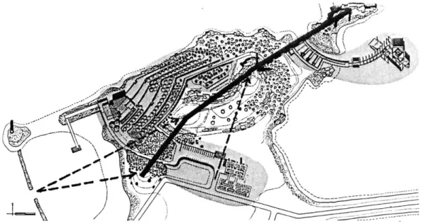
Site Plan- New Landscape Transformations
.. . W.. s .. . . .. - . .. ..-
e
, - ..-M
r
- - . In
i
I
The landscape is transformed in order to build each of the new places of the Sanctuary. The nature
of these changes varies throughout the site. A constant intention is to acknowledge previous
transformations and, at the same time, to heighten one's awareness
of the natural landscape. In this
way, layers of change and use are revealed which help one to
understand the site, not as a pristine piece of nature but as a gritty piece
of leftover land, a typical part of
industrial culture.
The proposed landscape transfor-mations are designed particularly for
a reclaimed landscape. They would
be inappropriate on a site that is more pristine and untouched. .When a piece of land has been ravaged by human development, a response is demanded which acts with the same intensity as the initial changes.
The Sanctuary will not, however mimic the past. The intention of the new landscape is fundamentally different than other intentions. Whereas exploitation of the land favors expediency, the type of landscape change suggested here promotes deeper human aspirations. An awareness of our connection to the natural landscape is fostered which suggests ways of building on the land which respects the nature
of the place.
"A lesson can be learned
from
theIndian cliffdwellings and earthworks mounds (earth art). Here we see nature and necessity in consort...
It is possible to have a direct organic manipulation of the land devoid of violence and 'macho' aggression....The farmer's, miner's or artist's treatment of the land depends on how aware he is of himself as nature. After all, sex isn't all a series of rapes. If strip
miners were less alienated from the
nature in themselves and
free
ofsexual aggression, cultivation could
take place."
(
42 The parking area is built by
cutting and filling. A large depression is made for a parking lot The fill is bermed at the edges to further intensify the bowl-like quality of the space.
The existing barracks are leveled and the largest is left in ruins, inhabited with a flower garden.
/ y
/
/
K
The harbor is made by building a
new breakwater. This breakwater is positioned perpendicular to the existing causeway so as to create
still water for a quiet harbor. The space of the harbor is made by juxtaposing old and new landscape elements. A light will be placed on
the existing vent tower to mark the place in the night.
Close-up of Site Model
44 The restaurant/meeting hall
is formed by a terraced
amphitheater. The terraces face the City of Boston to the north. Each of the terraces are retained by a stone wall and planted with apple trees creating a stepped orchard. At their edges, the teraces disappear
into the ground. The terraces culminate in a small performance stage. The northwest corner of the terraces are anchored by the meeting hall/restaurant. Its form grows out of the terraces, but steps up towards the city to create a sheltered south-facing courtyard.
Close-up of Site Model
IL1
e.The quarry at the center of the
site is made by continuing the act
of digging. A large bowl is dug
out to the depth of the existing hole. A rectangular pool of water with stone walls marks the edge. Shear quarry walls rise above the pool to the south. To the north, the fill from the continued quarrying creates a gentle berm planted with cedar trees. It has
terraced stone walls facing the pool and quarry walls to the south. There is a space between the new berm and the exisiting drumlins through which one enters.
7%
4,
46 The chapel is built by
transforming the landscape in a number of ways. A 20' wide channel is cut between the main body of the peninsula and Chapel Rock. There is always water in
this channel. At low tide only, stepping stones are revealed upon which one can cross the channel to Chapel Rock.
The Rock is the reference for the
organization of the chapel. All movement occurs along an arc with the Rock at its center. The tide pools are also built along this arc. These artificial basins facilitate an understanding of the rhythms of the tides. This landscape transformation prepares one for the experience of
the chapel.
%
~
I- . ~
CHAPTER 4. NEW ARCHITECTURAL INTERVENTIONS
-- -"-_--_-_-_A -- -.--- -
---Mill,
~Q
The Temple at Poseidon, Greece from Between Silence and Light
The architecture of the Sanctuary is an outgrowth of the new landscape transformations. They are the most dense layer of change. It builds a reference from which natural features of the place can be better understood. They attempt not to mimic nature in their form but to express ways that humans build to inhabit the land.
"It is a decision coming from the
commonality that you choose a place out of all places to build, a place where others can also settle.
It is a very important decision, of
the same importance as the positioning of a Greek temple
amongst the hills. Of all the hills, this hill is chosen for the temple,
and then all the other hills beckon
to it as if bowing to this decision. You do not see the hills now except
as respecting the decision of the placing of this eulogizing building,
which is remarkable in that it has never been there before."
Louis Kahn,
Site Plan- Architectural Interventions
N
52 The restaurant/meeting hall
is an architectural experience of the
terraces. Year round activity occurs in a garden-like setting. The siting of the building makes one aware of the conditions of the place. The south-facing courtyard creates an orientation within the building where one is aware of the sun's path. The large north-facing wall brings the view of Boston across
the harbor into the space. It creates a constant reminder of the presence of the city. Terracing in the building, stone paving, and lots of light and plants connect one back to
the terraced garden outside the
building. Just as the terraces are an intensification of the natural grade, the building transforms the terraces
by allowing year-round use. Future
layers of change may extend the building further into the terraces. Even if there is an abandonment of
the site, the terraces will remain as traces of former inhabitation.
The chapel is a further layer in
the changes that have occurred near Chapel Rock in the past two centuries. As in the past, a building is placed near the Rock to bring people to this special place. Also, like the earlier buildings, the structure of the chapel responds to the specific conditions of building in this place. What is different however is that the chapel explicitly references the Rock creating a structure that could be built in no other place. Chapel Rock, the changing tide, the rhythms of light, and the view of
the sea's distant horizon are all explicitly revealed in the architecture of the chapel. Later layers of change might alter the frame structure, adding or subtracting to accommodate new uses or the needs of a changed world. What will remain constant though, is a connection to the natural features of the place.
PART 2: THE LAYERS REVEALED
"We abuse land because we regard it
as a commodity belonging to us.
When we see land as a community to which we belong, we may begin to use it with love and respect."
Aldo Leopold,
A Sand County Almanac ~ww'-
£"~--'4
:~~-- I
56 INTRODUCTION
The previous section showed the site as a place in a continuum of both natural and human change. The sanctuary provides a
multi-layered experience of these changes. This experience links the world of
the city with the world of nature. The primary intention is to make visitors to the site more intensely aware of their ultimate reliance on nature for their physical and spiritual sustenance. It is not about getting lost in nature but bringing a profound experience of nature to the city-dweller which supports: "a belief in the identity of man and nature, one which humbles in its insistence upon the transitory nature of the merely human, but which, at the same time, dignifies
by its equal insistence that we are
all a part of something larger than ourselves."
Teiji Itoh, The Japanese Garden
Settings for a contemplative experience of nature are created which accommodate both personal and collective experiences. Even when an indoor space is created an ultimate reference back to the earth is always maintained.
"The sentiments upon which the
highest religion rests ... are on the
noblest objects of nature. Natural theology once had, and is destined in new forms to have again, a great
role in the intellectual side of
religious training. So, too, in
many summer meetings, twilight services on hills or exposed to vesper influences, perhaps out-of doors, are found to have wondrous reinforcements. Worship on a hill
or mountain, at the shore out at
sea, under towering trees, or in
solemnforests or flowery gardens,
amidst harvest scenes, in moonlight, at midnight, at dawn, in view of the full moon, with the noise of the winds or streams, the hum of insects, the songs of birds,
or in pastoral scenes, is purer and
more exalting for these pagan influences set to the music of
nature from which they all took their origin, than it can ever be in
stuffy churches, on noisy city streets upon the dull or familiar words of litany, sermon or Scripture. Here again, so-called
'progress' has broken too
completely with the past and
forgotten the psychogenesis of
religion, which has thus grown anemic, superficial and formal. It is the old error of amputating the tadpole's tail rather than letting it be absorbed to develop the legs that make a higher life on land
possible."
58 Ultimately, we rely on nature for our physical and spiritual
sustenance. In order to make visitors aware of this it is essential that they directly experience the natural features of the site. The Sanctuary is organized around the spine of drumlins which form the most distinct natural feature of the site. No building is undertaken on any of the high points of the site. No major movement ascends to these peaks. Instead, they are left as places to be discovered.
All building occurs to either side of
this spine but always in relation to it. Similarly the arrival to and the movement through the site orients visitors to the mounds but leaves them untouched.
Diagram showing relation of places to central spine of drunlins and site lines from entrances to high points of site
Each of the places in the Sanctuary links one to natural elements in a different way. Natural features of
the landscape are referenced in each
place. Gardens are planted with fruit trees, flowers, herbs and vegetables, showing a gentle use of nature. Groves of cedar, birch and pine mark unique elements and
transitions between places. The rhythms of nature which are manifest in the tides, the movement
of the sun, changing light qualities,
and the seasons are all made explicit in different ways. Making people aware of these rhythms is one way
of bringing them closer to nature.
The concept of sustenance upon which the sanctuary is based, is brought to the experience of the visitor by exposing them to the diverse natural features of the site.
Summer view of site
60 Previous transformations of the landscape directly inform the experience of the Sanctuary. The meaning and use of these changes are altered however so that they build a space designed for human activity.
The major places of the Sanctuary mark where there was previous building activity; the sites of the barracks, jetty, quarry, and resort are all actively built. The fact that the peninsula has changed so radically in the past demands an active stance
towards the designed landscape. To change peoples perception of a ravaged landscape, the experience of the site must actively offer an alternative. New uses for the site are given which incorporate previous transformations but which exploit the space-making
possibilities which the forms suggest. The jetty and the quarry were derived solely from expedient criteria. By making these spaces available for community use, the landscape is given a new meaning.
In the eighteenth century there was a legend about a mystical spring on the site:
"Over at Squanto's chapel yonder is
a fountain of a most remarkable power;for its waters cause a deep
sleep offorty-eight hours to those who drink forty-eight ounces at a draught and so on proportionably. As a reason for this property...the
Puritans of Plymouth have buried
their oldest and most soporific sermons within the grave of their honored and red-leggedfriend Squantum who lay buried there. But whatever be the cause, the fact is unquestionable. The great Powahs were accustomed to go thither to drink of the fountain, and when filled with its inspiration they would astonish their disciples with the multitude and magmficence of
their visions."
from King's Handbook of Boston Harbor,
This mythology and the naming of the rock formation as Chapel Rock suggests that special meaning has been attached to the site. The Sanctuary searches to re-establish this meaning by building upon the previous transformations,. and thereby make people aware of the special qualities of the site.
62 MOVEMENT
Movement through the site provides a basis for discovering the Sanctuary. Arrival by car or boat provides an introduction to the qualities of the site. Paths follows the topography and lead visitors to each of the places. Different types of movement occur at each place to bring forth the specific experience of the place.
The primary path bisects the center of the site and brings the visitor to each of the major places. It begins at the parking area and passes through a grove of pines moving up a series of low steps Pine trees were chosen because of the quiet mood they create through their repetitious verticality, their color and smell, and the softness of the ground underfoot from fallen needles.
Once past the grove, the path comes to the top terrace of the stepped orchard. The restaurant/ meeting hall appears at the bottom of the terraces. Beyond, over the water, is a direct view of downtown Boston. There are many ways to move down through the orchard. Several stairways connect each of the terraces.
The main path continues along the top terrace and as the path rises, a screen of birches separates the visitor from the terraces below. One walks along a stone retaining wall and is slowly aware of a large earth mound to the right topped with a grove of cedars. The path levels and there is a break in the mound; a small path turns to the right and descends to the bowl of the quarry.
The major path continues forward, skirting around the highest drumlin. Steep rock cliffs are to the right. As one rounds the corner, Chapel Rock is evident and the chapel becomes visible. The path goes downhill on axis with Chapel Rock. Behind is the largest
drumlin, evident on the return.
One passes the built tide pools and can continue straight ahead, down a ramp to a series of stones which cross the channel and lead to Chapel Rock. These stones are exposed only during low tide.
The main path arcs around the tide pools, two feet above the high tide mark. The stone path ends and a wooden walkway continues the arc out into the water through a series of concrete piers. The visitor has a constantly changing view of the Rock and the chapel .
At the chapel, one can either follow a ramp up to the chapel itself, or continue onward to a point where the mass of the chapel looms above. From this position, one is beyond the Rock and has a clear view of the horizon line of the ocean beyond.
A number of smaller paths traverse the site in a more casual way. The most important of these, rings the site at the shoreline providing easy public access along the water's edge. Access for vehicles is provided along this path between the parking area and the restaurant/ meeting hall.
Smaller cowpaths connect the shorepath, the central path, and the drumlins. Although none of the three high points on the site are built, one can climb to them along these incidental cowpaths
Site Plan- Movement
---64 The major path of the site is accompanied by a series of light fixtures which mark the way at night. The fixtures are made with a solid base which varies depending on its position in the site. At the entrance it is granite. Throughout the terraces it is made of the same puddingstone as the retaining walls. Past the path to the quarry, the base changes again and becomes
concrete.
The base in all cases has a reveal on each side into which stainless steel channels are positioned. The channels supports a ring which holds a spherical globe at its mid-point. Three u-shaped channels are held off the ground. A fourth closed channel holds the wiring and goes into ground. The heights of these channels from the ground varies according to the golden mean.
The intention of this fixture is to create an element which provides continuity through the site but marks the different conditions of each place. Its form and materials are related to the architecture of the restaurant and chapel. The lighting fixtures in each of the buildings will extend this theme.
Light Fixture- Elevation, Section, Folded Plan
\
ii
i~
(I
I I &
Chapter
5.
Arrival
6768 ARRIVAL
Coming to the site introduces the qualities of the sanctuary to the visitor. A parking area and harbor accomodates arrival by car or boat. Each of these places is made by further transforming aspects of the landscape that were previously built. The act of arrival makes visitors aware of the drumlins that traverses the length of the site.
Site Plan- The Sanctuary
--
A visitor by car approaches from
Marina Bay on the road to the community of Squantum. The road first passes some beautiful wetlands with a direct view of downtown Boston to the north. The parking area is at first hidden by a large berm to the left. The driveway to
the parking area becomes evident by a break in the berm and a large flower garden. A car enters the parking area on axis with the high point of the site.
The car descends eight feet into the depressed parking area, surrounded
by grass berms. Earth is given
dominance over the car; one's vehicle is put away and a new perception is engendered. A pine grove marks the main entrance to the sanctuary. A partially hidden gravel road provides service access to the restaurant.
The flower garden marks the entrance into another realm and extends into the site. Ruins of the former barracks lie within the garden. The garden is located in a large open field with a variety of wild grasses. This expanse faces the outer harbor islands and the community of Squantum. Casual recreation occurs here. A small sandy beach is accessible from this field. The shore path that circles the site is accessed from the northeast edge of the field.
Arrival by boat also introduces visitors to the site. The harbor faces the new development of Marina Bay as well as the inner passage to Boston. This location provides easy access for boaters to the site. Calm waters are created by building a new breakwater
perpendicular to the existing jetty. The jetty was constructed in order to erect a vent tower for an underground sewer line to Moon Island. Its form came solely from expeditious requirements; its length was enough to join the sewer line, its width allowed a vehicle to drive out for access to the tower. Its new use comes from the space-making possibilities inherent in the form.
Direct access to the restaurant/ meeting hall is available from the harbor. The dock is attached to the end of the jetty which stays above high tide. A portion of the jetty has eroded over time and the end containing the tower is now cut off from the site at extreme high tide. This dissolution and limited access provides an on-site precedent for the cutting action proposed on the other end of the site. Further, the isolation gives the vent tower a special significance. This significance is marked by giving the tower a new use appropriate to its form: a light beacon is placed on
it to mark the harbor at night and
reveal the presence of the Sanctuary
to the rest of the world.
Plan of Harbor
N
The building of the breakwater creates a space for the gathering of boats. The breakwater is made from rubble from the quarry. Boats enter the harbor through an opening in the breakwater which is directly on axis with the smallest drumlin
of the ridge which rises directly
The terraces are the first place that one comes to in the Sanctuary. They are meant as a more public and leisurely place than the chapel. The terraces, with their gardens, orchard and restaurant reflect the physical sustenance that nature can provide. A physical association between eating and agriculture is engendered; all in direct view of downtown Boston.
~.
Y MLAA terraced landscape in Italy
from Architecture Without Architects
by Bernard Rudolfsky
Site Plan- The Sanctuary
/
---78 The terraces are an intensification of the site's natural grade. Terracing
gives a form to the land which respects the natural contours of the site, while at the same time making it available for human use. An orchard and the architecture built into the terraces bring the slope of the hill into gentle harmony with human use.
A Roman Amphitheater from Stone and Man by Andreas Feininger
Close-up of site model
80 VEGETATION
The terraces are planted with apple and pear trees. A vegetable garden is at the western edge of the top terrace. On the north facing walls which define the restaurant's courtyard, there is an herb garden in the stepped retaining walls. The restaurant uses the fruit, vegetables and herbs in its fare. Moving through the gardens gives an impression of a useful landscape but one not in opposition to nature. The terraces merge to the east into a hardwood forest dominated by birch. The white birch creates a unique quality of light especially next to
the water. A garden from Garden Design
by Douglas et al
4Z
--
~- ~
7MOVEMENT
Movement through the terraces is casual and undefined. A number of stone stairways connect each of the terraces. One winds one's way through the orchard experiencing the place in any number of ways.
At the bottom of the terraces is the most intense use. A small stage
turns the orchard into an amphitheater during the summer months. People sit on the
terraces facing the city during
performances. The bottom terrace also connects to the path that circles the Sanctuary at the water's edge. At the corner of the terraces,
adjacent to the harbor is the restaurant/meeting hall. The shore path skirts this building and leads
to the harbor. A gravel service road
connects from this corner of the site back to the parking area.
THE RESTAURANT/
MEETING HALL
This building is the locus of public activity on the site. It
accommodates everyday use, whereas the chapel is intended for more special occasions. The restaurant provides the public with an introduction to the qualities of the Sanctuary. A large meeting hall on the second floor can be used for functions such as wedding receptions following a ceremony at the chapel. The complex can also be rented out as a conference center. Religious retreats would be especially appropriate here.
~-- ---
-Aft1 F~
A dining scene in the "De Overloop" building
84 The restaurant anchors the corner of the site. A protected south-facing courtyard results from this move. Its "back" protects the courtyard from cold northern winds but also opens to the view of Boston. The geometry of the main roof is derived from the direction of the jetty. A smaller section of the roof is shifted to remain pependicular to the curved terrace and to face the entry from the parking area. This section defines the edge of the inner
couryard.
A reference level passes through the The kitchen abuts the gravel service building at the level of the second
terrace. This level is the primary public space with entrances at both ends. It has a light metal shed roof which opens to the view from its high point but also lets in the warm southern sun. There is a garden-like atmosphere with stone paving and lots of light and plants which brings the experience of the terraces into the building. The northern edge of the building follows the curve of the terrace so
that the space is literally just a roofed extension of one of the outdoor spaces. A raised section
has an unrestricted view of the city, while another part of this space moves under the bermed roof to face the inner courtyard to the south. This section is raised six feet above the level of the court. Also under this lower roof is a sunken area with a large stone fireplace. This space connects directly to the courtyard.
road. Above the kitchen is the main meeting hall. It is reached from a large public stairway at the hinge of the public space. This room opens into the main public
space but can also be partitioned for privacy. The space is completely
open to the south and west with optimal views of the city and the sunset. A large outdoor deck extends to the edge of the water and also to the south. It is big enough to nearly double the size of the space during warm weather.
The administration for the Sanctuary is located in a raised section which anchors a corner of the courtyard. It is accessible from the main public space as well as from the courtyard and the terraces.
Restaurant/ Meeting Hall
Floor Plan
a. Outdoor Courtyard
b. Central Public
Space-Reference Level@ +14 c. Sunken Fireplace Area
d. Toilet
e. Administration
f. Stairs up to meeting hall g. Kitchen
h. Parking
i. Terraced Herb Garden
j..Orchard
k. Meeting Hall Deck above 1. Road to Parking Area m. Path to Harbor
85
86 STRUCTURE
The structure for this building is a concrete frame akin to the frame of
the chapel. Unlike the chapel
(i'however, the structure rises from a series of walls which define many of the spaces on the ground floor.
The walls derive from the act of
building on the land in a terraced
landscape. The structure extends
Section A-A
beyond the enclosed space to define areas around the building and create protection at the entrances. Different columns reflect different conditons throughout the building.
A square concrete column is
generally used often rising from a stone wall. In situations where different geometries are juxtaposed a circular column are introduced. Beams are generally concrete however, a light steel structure is used for the roof of the main public space.
Sections of Restaurant/Meeting Hall
''aP"6maamqa
Section B-B
CHAPTER
7.
THE QUARRY
,~4
The quarry forms another place in the Sanctuary. It is located off the main path and is intended as an informal space for quiet reflection. No paths lead directly to it; it is instead to be discovered.
The quarry was dug 100 years ago during the same time as the jetty. In fact, fill from the quarry probably helped build this jetty and the causeway to Moon Island. Its form came from hollowing out what was already a natural depression to expedite taking the maximum amount of fill from the site. As with the jetty and barracks the space-making possibilities of this form are exploited.
The digging action begun a century ago is continued to make a hollow at the level of the bottom of the existing pool. The fill from this digging creates a new berm which
further intensifies the bowl-like quality of the space. The presence
of the two highest drumlins on the
site and their connecting ridge creates a protected and quiet place
for contemplation.
Gentle terraces with stone walls at sitting height face the shear walls
of the quarry to the south. The
berm for the quarry is planted with cedar trees. These trees give a distinct aroma which differentiates the bowl as a special place. Because they are evergreens, the cedars also help provide a year round screen to noise and winds from the north. There is a space where the new berm meets the existing drumlins. It is through this space that one can enter the quarry area.
Site Plan- The Sanctuary
---- ---
-/
-: > -N * --- * 010 20 40 80
Plan of Quarry
ZN
CHAPTER 8. THE CHAPEL
The chapel derives its essential meaning from the natural landscape. This is evident in its movement and organization, as well as in the experience of the chapel itself. The tide pools are built where buildings existed a century ago. This marks the site of earlier intervention and leaves the Rock
itself unbuilt.
The chapel is conceived as a place for all religions denominations. Theology and doctrinal differences vary among religions but a respect for the natural is common to all; the chapel facilitates an experience
of nature that can bring different
faiths together. A place is created which allows visitors to interact directly with the natural features of the site: Chapel Rock, tidal movement of water, the horizon of the sea, and the rhythms of light.
"He listened to the thrushes in the gardens and heard a note which the cathedrals did not include: something
free and careless and
joyous... There was life outside thechurch. He thought of God, and of the whole blue rotunda of the day. That was something great andfree. He thought of the ruins of the
Grecian worship, and it seemed a temple was never perfectly a temple, till it was ruined and mixed up with the winds and the sky and the herbs".
D.H. Lawrence, The Rainbow
CIL.
Site Plan- The Sanctuary
98 CHAPEL ROCK
The name of the Rock signifies the special status the site had for previous inhabitants. The Sanctuary proposes to return this meaning to the Rock. It is the primary reference to which the chapel is organized.
Conferring special status on natural features is one way of making them sacred. In Japan, two rocks are tied
together and wedded and thereby
become the "first family", revered
by all Japanese. In this country, a
prominent rock formation receives a name like "Old Man of the
Mountains" in New Hampshire and becomes a major tourist attraction, appearing on license plates as a special sign. Both instances show ways in which humans derive meaning from nature.
At this site, a channel is cut between Chapel Rock and the rest
of the peninsula, making it
accessible only at low tide and thus conferring a sacred status to the place.
One moves out to the chapel along an arc whose center point is the high point of Chapel Rock. This journey allows a constantly changing perception of the Rock. The ramp up to the chapel is on axis with the high point. As one descends the ramp after a visit to the chapel, the Rock is directly falced.
Plan of Chapel and Tide Pools
99 Chapel Rock Suspended Walkway Chapel7
01020 40 80100 TIDES
The ebb and flow of the tides is an important feature of this place. The water level varies up to twelve feet during a full moon. Average tides vary ten feet between high and low tides.
The built tide pools make the rhythms of the tide explicit and form an integral part of the experience of the chapel.
101
Site Plan- Tidal Zone
N 10...--.
--...
...-
1.-.-~
-..-..
{.-
...-..-..
*...
*1-0 Au102 The pools are a series of stone basins that the tide fills as it rises showing six different heights from low tide to high tide. The water outlet is through a 1" wide slit. The outlet allows the water to exit
much more slowly than the tide lowers thus the basins retain the water even after the tide recedes.
By the time the water reaches low
tide the pools are drained and ready to be refilled.
High tide pools mark the beginning and end of the built tidal sequence. As one enters the sequence from the site, there is a ramp which the water slowly inches up as the tide rises. At high tide, the ramp is submerged and water spills under the walkway into a basin. The visitor can visually mark time by observing the position of water on this ramp.
At the end of the tidal sequence, at the beginning of the suspended walkway out to the chapel, there is another high tide pool. The two concrete side walls of the basin rise to twelve feet above the walkway and are the only things evident of the pool during high tide. Each wall has a one inch vertical slit of light at the center. The walls form a room that the visitor passes through, serving as a threshold to the chapel. As the tide goes down the pool itself is revealed. The slit allows water to escape but more slowly than the retreating tide. The pool slowly empties only to be refilled by the next high tide.
Movement through the system is 13
also tide-dependant. A series of stone walkways separate the pools and are accessed by steps down from
the main walkway which is always above the high tide mark. The walkways actually form the lip for each pool. They all connect to a lower arc which slowly ramps up to join the main walkway. This system of movement is variably flooded by the changing tides. At high tide all that is perceived of this system is a series of steps
descending into the water.
A variable, tide-dependant
experience of filling and emptying constantly marks the changing tide.
By passing through this system, a
visitor is made more aware of the natural rhythms of the tide.
The following drawings show the water levels in the tide pools as the tide changes. It reveals how subsequent basins fill with water as
the tide rises. Water slowly moves up the ramp to the first high tide pool until ultimately it spill in. The last tide pool also fills at this time and merges with the
surrounding water. The only trace are two concrete planes emerging