HAL Id: hal-00296856
https://hal.archives-ouvertes.fr/hal-00296856
Submitted on 9 May 2005
HAL is a multi-disciplinary open access
archive for the deposit and dissemination of
sci-entific research documents, whether they are
pub-lished or not. The documents may come from
teaching and research institutions in France or
abroad, or from public or private research centers.
L’archive ouverte pluridisciplinaire HAL, est
destinée au dépôt et à la diffusion de documents
scientifiques de niveau recherche, publiés ou non,
émanant des établissements d’enseignement et de
recherche français ou étrangers, des laboratoires
publics ou privés.
The geological record of storm events over the last 1000
years in the Salerno Bay (Southern Tyrrhenian Sea):
new proxy evidences
F. Budillon, E. Esposito, M. Iorio, N. Pelosi, S. Porfido, C. Violante
To cite this version:
F. Budillon, E. Esposito, M. Iorio, N. Pelosi, S. Porfido, et al.. The geological record of storm events
over the last 1000 years in the Salerno Bay (Southern Tyrrhenian Sea): new proxy evidences. Advances
in Geosciences, European Geosciences Union, 2005, 2, pp.123-130. �hal-00296856�
SRef-ID: 1680-7359/adgeo/2005-2-123 European Geosciences Union
© 2005 Author(s). This work is licensed under a Creative Commons License.
Advances in
Geosciences
The geological record of storm events over the last 1000 years in the
Salerno Bay (Southern Tyrrhenian Sea): new proxy evidences
F. Budillon, E. Esposito, M. Iorio, N. Pelosi, S. Porfido, and C. Violante
Consiglio Nazionale delle Ricerche, Istituto per l’Ambiente Marino Costiero, Calata Porta di Massa, 80 - 80133 Napoli, Italy Received: 19 November 2004 – Revised: 7 March 2005 – Accepted: 10 March 2005 – Published: 9 May 2005
Abstract. The shallow marine Late Holocene wedge of the
northern Salerno Bay shelf (Southern Tyrrhenian Sea) dis-closes the presence of four decimetric shelf-tapering sand beds. Their internal features, depicted by cores analysis and their stratigraphic position, revealed by VHR seismic inves-tigations, inferred sandy layers as being the result of flash de-position, storm controlled, thus episodic. Stratigraphic corre-lations among cores lead to constrain sandy layers deposition to storm events falling in the 11th, 16th, 19th and 20th cen-turies. A certain attribution of the most recent event bed to the major cloudburst that hit the Salerno region in 1954 A.D. and resulted in a disastrous flood of the Bonea stream, was formerly achieved. A tentative link with two sea-storms that occurred in the 1544 A.D. and in the 1879 A.D. and well doc-umented by historical sources is here proposed to explain the deposition of the two previous event beds. The depo-sition of these sandy layers must be related to major storm events, since their preservation in the stratigraphic record is not common. Lithostratigraphic and textural differences between flood and sea-storm emplacement emerge from the study of sandy layers in cores and point to a prevalence of sea-storm deposits in the middle shelf compared to flood de-posits. Seismic stratigraphic evidence lead us to suppose that the style of episodic flash deposition has been running on for the last 2–3 kyr and is probably linked to a climatic trend of the region.
1 Introduction
Sharp based sandy layers interlayered in muddy sequences of middle shelf environment are normally regarded as a proxy for past storminess. In fact, both down-welling currents orig-inated by sea-storms (Myrow and Southard, 1996) and hyper-pycnal flows, i.e. high density sediment charged underflow, generated at the river mouth by floods (Mulder and
Syvit-Correspondence to: F. Budillon
(francesca.budillon@iamc.cnr.it)
ski, 1995) are dynamic erosional/depositional processes re-lated to intense cyclonic circulation at the middle latitudes. Both processes are particularly effective in delivering huge amounts of sand to the infralittoral and circalittoral environ-ment and settle sharp based sandy layers, with possibly very similar lithologic features. Most of the diagnostic elements for recognizing hyperpycnal flow deposits (HFD) come out from observations at the field scale of the inland geological record (Froese et al., 2003; Mutti et al., 2003). It is widely accepted that flood deposits are more widespread and there-fore more accurately documented in the geological record than those in the modern shelf environment (Mutti et al., 2003; Geyer et al., 2004). Analogous considerations can be supported for sea-storm deposits (tempestites), which ap-pear more consistent in the geological record (Dott and Bour-geois, 1982; Duke, 1985; Myrow and Southard, 1996) than in the modern shelves, where rarely more than 10 cm thick sand layers have been depicted (Morton, 1981; Niederoda et al., 1989; Snedden and Nummendal, 1991). The above in-dications, point to a practical difficulty in discriminating hy-perpycnal flow from tempestite deposits on modern shelves by standard marine investigations (cores analysis and seis-mic surveying). In the Mediterranean area major sea-storms related to cyclonic circulation are often accompanied by cold fronts inducing heavy rainfall (Jansa, 2000; Ramos, 2000a, 2000b). Hyperpycnal flows at the mouth of flood-prone rivers can be triggered with a response of few hours espe-cially in small sized catchments (Siccardi, 1996). In these cases both processes may couple in delivering and rework-ing sand in the littoral zone (Fan et al., 2004; Guillen et al., 2005).
The aim of this study is to provide practical diagnostic ele-ments to distinguish the two depositional processes related to storm deposition by sediment core analysis and seismic sur-veying in shelf areas. A case study carried out off the Bonea stream mouth (Salerno Bay, Southern Tyrrhenian Sea, Fig. 1) is here presented; the use of several methodologies resulted in the chronologic constrain of the timing of storm related sandy layers deposition (Budillon et al., 2005); an attribution
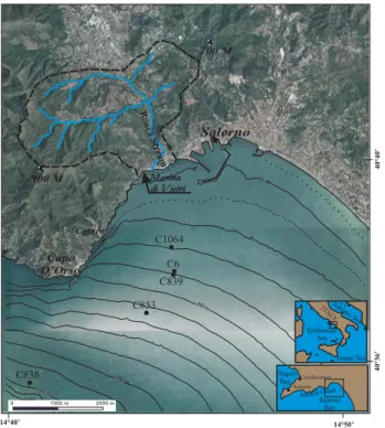
124 F. Budillon et al.: The last 1 ky storm events record in the Salerno Bay (Southern Tyrrhenian Sea) C1064 C853 C836 C6 C839 Salerno 900 M Marina di Vietri Marina di Vietri Cetara Capo D’Orso 10 m 50m 50m 50 m 100 m 10 m 14°40’ 14°50’ 40°40’ 40°36’ 0 1000 m 2000 m 120 m 700 M Bonea Str eam Amalfi Coast Salerno Bay Castellammare Sorrento Napoli Bay Adriatic Sea Ionian Sea IT AL Y Tyrrhenian Sea
Fig. 1. Topography of the Salerno Bay shelf and coast and location of gravity cores. Dashed line bounds the Bonea stream catchments.
to storm events reported by historical sources is then here attempted.
2 Geological setting
The Bonea stream (Amalfi coast, Southern Apennines, Italy), flowing in the Salerno Bay (Fig. 1) has a drainage system ex-tending over 22 km2of a mountainous region of the Southern Apennines (Brancaccio et al., 1991). The high gradient of the Bonea fluvial path and the shortness of the transfer zone accounted for sediment charged flows moving rapidly down-stream into the Salerno Bay during intense rainfalls (Espos-ito et al., 2004a). The fluvial regime of the Bonea Stream is typical of the Apennines, with low yields during Spring and Summer, and maximum capacity during Autumn and Win-ter, when seasonal rainfall reaches a peak and south-westerly cyclonic storms are more intense (Ramos, 2000a, 2000b). The Bonea stream flows in the Salerno Bay, which is charac-terised by a continental shelf about 9 km wide and is bounded seawards by a sharp shelf break at 120 m of depth (Fig. 1). Shelf gradient ranges between 0.6◦and 1◦and is accounted for by the geometry of the Late Holocene marine wedge. Well sorted sand, distinctive of the nearshore environment, spreads all along the northern coast of the Bay, down to 15 m of depth; deeper it gives way to less sorted muddy fine sand, typical of the inner shelf environment (Cocco et al., 1992).
The Salerno Bay is exposed to storms coming from N 190◦and N 280◦and the maximum fetch corresponds to the sub-sector 230◦–260◦(660 nm) where the greatest number of
wave-generating events originate. Storm waves approaching the coast from N 190◦–N 220◦(about the 25% of the events)
and from N 270◦–N 280◦induce alongshore currents
respec-tively towards NW and SE (Cocco et al., 1992).
3 Methods and materials
This study makes use of Very High Resolution (VHR) Sonar Chirp Lines, shot normally to the Bonea stream coast. Five gravity cores were used to gauge seismic facies. Grain size analysis was carried out on sandy layers found in cores ev-ery 5–10 cm with a spatial resolution of 3 cm; sand was sieved through size classes of 500, 250, 125, 63 and 30 micron and weighted. Results were plotted on a modified Shepard (1954) diagram in order to point out the differences between hyperpycnal flow and tempestite deposit textures. Spectrophotometer measurements were taken with a Minolta Spectrophotometer CM 2002, and chromaticity parameter (a*) logs were added for three cores (C1064, C839, C853) to reinforce lithostratigraphic and magnetic susceptibilities correlation among cores (Budillon et al., 2005). The mea-surements were taken immediately after cores splitting in or-der to minimize redox-associated colour changes that occur when marine sediment is exposed to the atmosphere. A criti-cal analysis of inventories, archival documents and literature was carried out in order to select major sea-storm events that hit the Salerno Bay over the last five centuries.
4 Results
4.1 Inventories of sea-storms in the Salerno Bay area
Based on the critical analysis of historical documents, ten major sea-storm events were recognized in the Salerno Bay between the 1544 and the 1900 A.D., among 35 events re-ported, and were classified as medium and heavy events (Ta-ble 1). The severity of these events was evaluated on the basis of several factors as the number of victims, the size of the coastal zone involved, damage on properties, harbour structures and littoral areas, and the number of times a single event is mentioned in archival documents. A widespread pat-tern of destruction characterized some of them, with numer-ous casualties, shipwrecks, loss of fleets, damage to harbours and coastal buildings. Among these events, the 1544, 1774 and 1879 A.D. sea-storms lead to a high number of deaths. The 1544 A.D. sea-storm has been widely reported because it caused the destruction of the fleet of the ill-famed Turkish pirate Khayr ad-Din, also known as “Red beard” (Camera, 1836). His whole fleet sunk in the proximity of Capo d’Orso (Fig. 1).
4.2 Lithostratigraphy of cores and correlations
The litho-stratigraphy of cores indicated four sharp based sandy layers in the muddy Late Holocene wedge (Fig. 2), thinning seaward. Correlations of sandy layers across cores
Table 1. Major sea-storm events since the 16th century, deduced from: Archivio di Stato di Salerno (AS SA), Protocolli notarili, 1500–1798; Archivio di Stato di Salerno, (AS SA), Prefettura, 1879; Camera, M. (1836); Greco, M. (1709–1787).
Date Localities Sea-storm induced effects Sources Note
1544.06.27 Capo d’Orso, Amalfi Coast, Destruction of the fleet of the Turkish M. Camera, 1836 Heavy
Salerno pirate Khayr ad-Din also known
as “Redbeard”.
1597 Amalfi Coast, Salerno Bay Damage to 2 buildings in Marina di Vietri, ASSA, Protocolli notarili, 1597 Medium
destruction of 2 ships.
1759.11.21 Salerno Damage to boats, 1 lost, 1 casualty. M. Greco, 1709–1787 Medium
1770.04.13 Sorrento, Castellammare One fallen boat, with 12 casulties. M. Greco, 1709–1787 Medium
1774.11.25 Salerno, Vietri sul Mare, 2 vessels lost in Salerno, 4 others damaged M. Greco, 1709–1787 Heavy
Napoli Bay in Vietri sul Mare and Naples.
Damage to the Naples harbour.
1774.12.03 Salerno M. Greco, 1709–1787 Medium
1776.09.12 Salerno, Vietri sul Mare. M. Greco, 1709–1787 Medium
1778.01.08 Salerno M. Greco, 1709–1787 Medium
1781.11.24 Salerno 1 casualty. M. Greco, 1709–1787 Medium
1879.02.25 Amalfi Coast, Vietri sul Mare, 10 vessels are lost, 9 casualties AS SA, Prefettura Heavy
Salerno in the Vietri offshore.
0.8 1.2 1.6 2 2.4 a* 0.4 0.8 1.2 1.6 2 a* 1-11 Mud Sandy mud Poorly sorted sand Well sorted
sand Pumice layer
Parallel bedding Wavy bedding
Cross-bedding
Magnetic susceptibility peak Erosion surface
Normal grading Inverse grading
Tempestite layer Flood layer Ash layer Legend E T F C853- 62m Silt Sand E4 7 8 9 10 11 11 1 3 4 5 0 200 400 Silt SandSand C836 - 113 m 0 200 400 1-3 8 11 12 7 0 100 200 300 400 (cm) C1064-29 m Silt Sand E1 E2 F 6 1 2 3 4 5? 0 200 400 0.8 1.2 1.6 2 E3 E1 E4 C6 -36 m Silt SandSandM 7 8 9 10 1 2 3 4 5 6 0 200 400 C839-37m Silt Sand 7 8 5 6 0 200 + a*
SIx10-5 SIx10-5 SIx10-5 SIx10-5 SIx10-5
6 4 T1 T2 T3 V2 V1 V T1 T1 F T2 Level sampled for grain size
V volcanics T2 V T1 79 A.D. Somma-Vesuvius Plinian eruption 1954 A.D.1963A.D.
1822 A.D. Vesuvius eruption
stratigraphic level of T2
1000 y. B.P. 450 y. B.P.
1300 y. B.P.
450 y B.P. (Paleomagnetic dating) 1822 A.D. (Tephra-chronology) 1963 A.D. ( Pb and210 137Cs depth activity profiles)
Fig. 2. Core logs and correlation of event beds based on magnetic susceptibility (m.s.), chromaticity (a*) and lithology. 1–12 are the magnetic susceptibility and parameter a* chromaticity peaks that lead to the correlation of F and T layers among cores. Arrows indicate the stratigraphic position of grain size analysis. Magnetic susceptibility measurements are expressed in S.I. units (Sommerfeld International System). Dating are from Iorio et al. (2004) and Budillon et al. (2005).
126 F. Budillon et al.: The last 1 ky storm events record in the Salerno Bay (Southern Tyrrhenian Sea) Events F T1 C1064_T2 C839_T2 T3
Coarse to fine sand
Very fine sand Mud
F/1 F/2 F/3 F/4 F/5 T1/1 T1/2 T1/3T2/1 T2/2 T2/3 T2/4 T2/5 T2/6 T2/7 T3/1 T3/2 T3/3 T3/4
Fig. 3. Results of grain size analysis on T and F sandy layers of cores C1064, C853, C839 and C6 are plotted on a modified Shep-ard (1954) diagram. The grain size classes represented at triangle vertex are from Wentworth (1922) scale as follows: coarse to fine sand (500 microns>grain size>125 microns), very fine sand (125 microns>grain size>63 microns), mud=(grain size<63 microns).
have been supported by visual and mathematical compari-son of petrophysical parameters and similar trends according to the litho-stratigraphy (Fig. 2). The magnetic susceptibil-ity (m.s.) parameter is related to the ferromagnetic mineral content in sediment, while the chromaticity parameter (a*) is thought to be related, among other factors, to the grain size of the deposits (Nagao and Nakashima, 1992), and thus is useful for univocally correlating sandy layers. In particular, the identification of m.s. peaks 4, 5, 8, and 6 leads to the cor-relation of TI and T2 sandy layers in cores C839 and C853, while 11 m.s. peak recognition and lithostratigraphic consis-tency lead to correlate T3 sandy layer in cores C6 and C853; on the contrary, the correlation of peak 5, identified in core C1064, remains uncertain across the others (Fig. 2). The up-permost sandy layer F has been related to the flood event of the 1954 A.D. of the Bonea Stream, that produced a poorly sorted coarse grained sandy layer 20 cm thick at a distance of 2.6 km from the stream mouth (Budillon et al., 2005; Vi-olante and Budillon, 2004). In this case a hyperpycnal flow, gave rise to the flood deposit (F) in the mid-shelf environ-ment. The sharp based sandy layers below the Bonea stream flood were attributed to major sea-storm events on the basis of their lithologic features and lateral continuity (Budillon et al., 2005). The event beds identified in cores C1064, C6, C839 and C853 were calibrated by correlating petrophysi-cal peak values to a dated core (C836), by210Pb and137Cs geochronology and by the stratigraphic position of the 1822 A.D. Vesuvius tephra. All of the information collected lead to constrain these events to the last 1000 years, and in par-ticular T1 as being deposited in the 19th century, T2 in the 16th century and T3 in the 11th century (Iorio et al., 2004; Budillon et al., 2005).
4.3 Grain size, textures and grain fabric of sandy layers
The grain fabric of tempestites is generally related to the dif-ferent phases of the underflow motion (Dott and Bourgeois, 1982; Niederoda et al., 1989) which may produce a normal grading, a parallel and a wave layering of sand. A remark-able difference was observed among textures and grain fab-ric of sand layers even if occurring in the same core (C1064, Fig. 2; Budillon et al., 2005; Violante and Budillon, 2004). A modified Shepard (1954) diagram was used to plot grain size results (Fig. 3). Instead of the classic vertex represented by clay-silt-sand fractions (Shepard, 1954), sand, very fine sand, and mud were positioned at the triangle vertex in order to adjust the diagram to the real lithology of sandy layers. As shown in Fig. 3, samples of F deposit fall in the central – left side of the triangle, testifying a poor sorting of grains and are set apart from the position of other samples. On the contrary samples from T deposits are concentrated on the left side of the diagram, indicating a good sorting of grains and a prevalence of very fine sandy fraction.
All T layers then pass gradually into mud, which repre-sents the waning phase of the underflow motion induced by a sea-storm (Wright et al., 2001). Subsequently a cup of hemipelagic mud seals tempestite deposits and point to the inter-storm time span. Nevertheless, only the T2 layer in core C6 shows the theoretical grain fabric of tempestites, while other T layers do not, except for a general fining up trend. This point is not casual but could depend on the fact that the T2 layer in the C6 core is the thickest layer (about 80 cm) among tempestite deposits found in studied cores. As described in Keen et al. (2004), benthic organisms, whose activity is higher in areas with low sedimentation rates, may burrow the first 10 cm of seafloor sediment in one year of time, and then quickly destroy the original sedimentary struc-tures. If the tempestite sandy layer is thick enough and the rate of burial is high, it has more possibilities to maintain its original grain fabric (Wheathcroft and Drake, 2003), as likely happened at level T2 in core C6.
4.4 Structures of the hyperpycnal flow versus tempestite layers
Lithostratigraphic observations on F and T layers evidenced the peculiar structure of the hyperpycnal flow generated by the 1954 A.D. Bonea stream flood (Esposito et al., 2004b; Budillon et al., 2005). The inversely graded sandy mud inter-val below E1 (Fig. 2) may be accounted for by the increasing rate of discharge at the river mouth (Mulder et al., 2003) due to the persistent heavy rainfall; E1 erosion surface, and the overlaying coarse bed rich in vegetal debris (Fig. 4), could be the consequence of river wave flood due to dams break down and subsequent overcharged flux to the coast (Esposito et al., 2004b). In that case the erosion surface E1 would have the significance of the “intrasequence erosional contact” of Mulder et al. (2003). The erosive potential of the hyperpy-cnal flow and its thickness rapidly decreased seaward, since only a thin sandy layer overlays the E1 surface in C6 core
Intrasequence erosional surface inversely graded layer, relative to the increasing fluvial discharge
Poorly sorted, coarse grained sandy layers, containing bioclasts and vegetal debris
Hyperpycnal flow
marine mud
with shells in living position and burrows
marine mud
with shells in living position and burrows
marine mud
with shells in living position and burrows
marine mud
with shells in living position and burrows
well sorted sandy layer normally graded
Tempestite
clay chips and bioclasts basal erosional surface Fanerogamae debris 60 cm 60 cm Hemipelagic deposition Hemipelagic deposition Hemipelagic deposition Hemipelagic deposition T empestite de position Hyper pycnal fl o w de position Flood de poistion flood w av es
Fig. 4. Schematic stratigraphic representation of hyperpycnal flow and tempestite deposits as recognizable by marine sediment cores obser-vations.
and no coarse bed is found at the same stratigraphic level in the C853 core (Fig. 2). On the contrary, T sandy layers cut invariably into marine mud. The coarse sand immediately above the basal erosional surfaces often includes clay chips, thus testifying the erosive potential of tempestite underflow currents. Sand deposit is richer in benthic foraminifers and in bioclasts than in woods and vegetal debris, and is gradually replaced upward by the mud. The mud interval containing gasteropods in living position (in this case Turritellae shells) and pervaded by a dense net of burrows can be interpreted as being the hemipelagic mud, thus not pertaining to the tem-pestite deposition. Also, in the Mediterranean Sea sediment-charged flows of sea-storm origin may normally contain bio-clasts and Posidonia oceanica debris (T2 in core C6, Fig. 4), because they winnow and rework the shallow marine sedi-ment over a large portion of coastal areas.
4.5 Chronologic constrain of tempestites
An attribution of T1, T2 and T3 layers to the 11th, 16th, 19th centuries respectively was attempted in Budillon et al. (2005), based on correlations with a dated core (C836), tephra-stratigraphy and geochronology (Fig. 2). The criti-cal analysis of inventories, here reported, resulted effectively with three major events that occurred in 1544, 1774 and 1879 A.D. and among these, the first sea-storm hit the coast in the surrounding of Capo D’Orso in particular. A good cor-relation between our deductions and reported storm events could lead to the attribution of the T2 sandy layer (16th cen-tury) to the 1544 A.D. event and the T1 (19th cencen-tury) to the 1879 A.D. event. The T2 tempestite extends mainly in the proximity of Capo d’Orso, as revealed by seismic lines (Budillon et al., 2005; Violante and Budillon, 2004), thus reinforcing a possible genetic link between this layer and the sea-storm of the 1544 A.D. The 1774 A.D. event seems to lack in cores if we consider this sea-storm as heavy as
the T2 and T3 events. Actually, very thin sand layers and sand patches are present at various depths in cores (Fig. 2) but without any other constrain (texture, erosional basal con-tact. . . ) it would be inappropriate to try to correlate discon-tinuous sandy levels to a sea-storm event, even if the strati-graphic position would allow it.
4.6 Tempestite layers from VHR seismic profiles
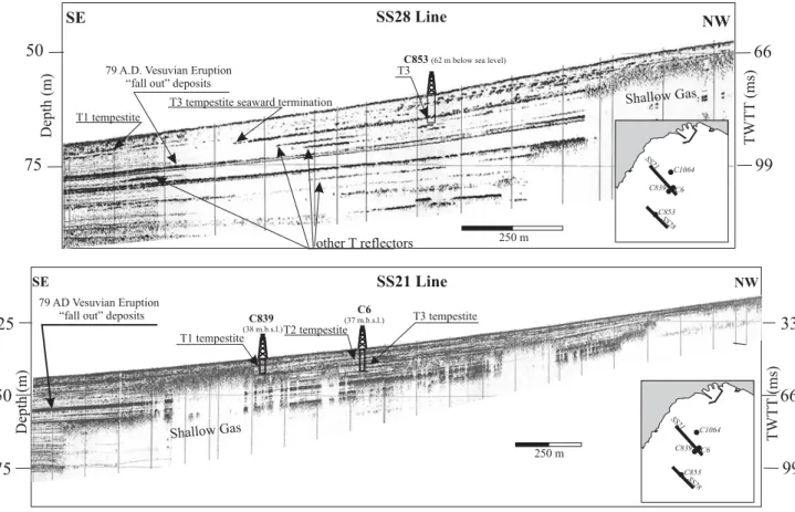
Very high resolution chirp profiles allowed to identify reflec-tors bouncing back from tempestite sandy layers, occurring in the stratigraphic record of the Salerno shelf (Fig. 5). Seis-mic reflectors corresponding to tempestites show high vari-able amplitude and even some interruptions at places; never-theless they are recognizable throughout a wide sector of the northern Salerno shelf. They develop between 20 and 60 m of water depth and show a sharp termination seaward, due to the thinning of sand layers below the instrument resolution (about 30 cm). The lateral distribution of T reflectors allowed to figure out the large amount of sand mobilized and trans-ported down slope during a major sea-storm, when the con-ditions to develop down-welling currents are achieved (My-row and Southard, 1996). The depth of penetration of cores let us gauge the seismic record for the first 6–10 msec (two way travel time); however very similar reflections to the ones corresponding to T layers in cores are present in the seis-mic record even below (Fig. 5). In particular two tempestite-like reflections develop below the T3 reflector and above the Vesuvius pumice deposit related to the 79 A.D. plinian erup-tion (Buccheri et al., 2002) and two others develop below it. This could mean that the same style of deposition has been running since 3 kyr B.P. Tempestites are mostly represented in the seismic record of the mid-shelf because they develop as fine grained sand (Fig. 3) in the shelf depocentres, they are visible by VHR seismic investigations and they are easily sampled by gravity coring. On the contrary hyperpycnal flow
128 F. Budillon et al.: The last 1 ky storm events record in the Salerno Bay (Southern Tyrrhenian Sea)
66
99
50
75
NW SE SS28 Line Depth (m)C853(62 m below sea level)
79 A.D. Vesuvian Eruption “fall out” deposits
T3 tempestite seaward termination
other T reflectors TWTT (ms) C839 C853 C6 C1064 SS21 SS28 Shallow Gas T1 tempestite T3 250 m C839 C853 C6 C1064 SS21 SS28
66
99
50
75
33
25
NW SE SS21 Line TWTT (ms) Depth (m) C6 (37 m.b.s.l.) C839 (38 m.b.s.l.) 79 AD Vesuvian Eruption “fall out” depositsShallow Gas
T1 tempestite
T3 tempestite T2 tempestite
250 m
Fig. 5. Very high resolution seismic lines (Sub-bottom Chirp) shot normally to the Bonea stream coast show the extention of tempestite deposits..
deposits, mostly coarse grained, in particular the one from the Bonea stream, are confined to the inner shelf (Budillon et al., 2005), where sandy fractions prevail. These factors make it more difficult to identify HFD in the stratigraphic record of the inner shelf by means of VHR seismic survey due to the acoustic masking potential of sand. Furthermore, as demonstrated by several authors, event beds in the shal-low marine environment undergo resuspention and winnow-ing due to the reworkwinnow-ing action of high amplitude waves dur-ing “dry storms” (Weathrcroft and Drake, 2003; Guillen et al., 2005)
5 Conclusions
Both hyperpycnal flows from flood-prone stream and tem-pestites occurring as sand layers in the stratigraphic record of shelf areas are event beds regarded as a proxy of past stormi-ness. A typical structure of a proximal hyperpycnal flow and of a tempestite has been described in order to facilitate their identification by means of standard geological marine sur-veying (gravity cores and seismic investigations). The case study of the Salerno Bay shelf record lead us to recognize four event beds related to major storms that occurred in the area during the last 1 kyr. The most recent bed (F) was re-lated to the extreme flood event that hit the Salerno region
in 1954 A.D. (Budillon et al., 2005; Violante et al., 2004). The two event beds below have been here interpreted as be-ing possibly generated by two major sea-storms occurred in 1544 and 1879 A.D. respectively, while the oldest tempestite remains with an unknown attribution. It is likely that other tempestite event beds occur in the stratigraphic record of the Salerno shelf as it emerges by seismic lines interpretation. At least two other major events may have deposited a thick sandy layer (thicker than the threshold of the instrument reso-lution, which is about 30 cm) above 79 A.D. Vesuvius tephra and below the T3 tempestite, and two more major events could have acted between the 79 A.D. and 3.3 kyr (Conforti, 2003). All these elements match well with the hypothesis of a climatic trend degradation inferred for the last 3 kyr in the area and depicted by archaeological, biostratigraphic and lithostratigraphic data (Allocca et al., 2001; Buccheri et al., 2002; Iorio et al., 2004).
The reconstruction of remarkable events on land and in the shallow marine sediment record highlights the flood- and sea wave-related hazard and the associated risk to which the Salerno coastal area is exposed, when major storms hit the coast and go so far as to have an impact on the morphology of the shore and of the seabed.
Acknowledgements. The present research has been developed with
the financial support of MIUR in the frame of Cluster 10, Project n. P04 (GeoSed – Geomorfologia e sedimentologia di settori selezionati della piattaforma continentale dell’Italia Meridionale). The authors are grateful to Patricia Sclafani and two anonymous referees for the reviews to the manuscript.
Edited by: L. Ferraris
Reviewed by: anonymous referees
References
Allocca, F., Amato, V., Coppola, D., Giaccio, B., Ortolani, F., and Pagliuca, S.: Cyclical climatic-environmental variations during the Holocene in Campania and Apulia: geoarcheological and pa-leoethonological evidences, Mem. Soc. Geol. It. 55, 345–352, 2000.
Archivio di Stato di Salerno, (AS SA), Intendenza, 1800–1899. Archivio di Stato di Salerno, (AS SA), Prefettura 1834–1924. Archivio di Stato di Salerno, (AS SA), Protocolli notarili 1500–
1798.
Brancaccio, L., Cinque, A., Romano, P., Rosskopf, C., Russo, F., Santo, A., and Santangelo, N.: Geomorphology and neotec-tonic evolution of a sector of the Tyrrhenian flank of the South-ern Apennines (Region of Naples, Italy), Zeit. Geomorph., N.F., Suppl. Bd., 82, 47–58, 1991.
Buccheri, G., Capretto, G., Di Donato, V., Esposito, P., Ferruzza, G., Pescatore, T., Russo Ermolli, E., Senatore, M.R., Sprovieri, M., Bertoldo, M., Carella, D., and Madonna, G.: A high reso-lution record of the last deglaciation in the southern Tyrrhenian Sea: environmental and climatic evolution, Mar. Geol. 186, 447– 470, 2002.
Budillon, F., Violante, C., Conforti, A., Esposito, E., Insinga, D., Io-rio, M., and Porfido, S.: Event beds in the recent prodelta strati-graphic record of the small flood-prone Bonea stream (Amalfi Coast, Southern Italy), in: Mar. Geol., special issue, edited by: Syvitski, J. P. M. and Trincardi, F., in press, 2005.
Camera, M.: Istoria della citt`a e costiera di Amalfi, 1836, Ristampa anastatica, Sala Bolognese, 1985.
Cocco, E., de Magistris, M. A., Efaicchio, M. T., and Boscaino, F.: Geoenvironmental features of the Sele river littoral plain (Gulf of Salerno, Southern Italy), Boll. Ocean. Teor. Appl., 10, 235—246, 1992.
Conforti, A.: Stratigrafia integrata della sequenza
Tardo-Quaternaria del settore settentrionale del Golfo di Salerno e di quello meridionale del Golfo di Napoli, Unpublished PhD The-sis, Universit`a Federico II di Napoli, pp. 144, 2003.
Dott, R. H. and Bourgeois, J.: Hummocky stratification: signif-icance of its variable bedding sequence, Geological Society of American Bulletin 93, 663–680, 1982.
Duke, W.: Hummocky cross-stratification, tropical hurricanes, and intense winter storms, Sedimentology 32, 167–194, 1985. Esposito, E., Porfido, S., Violante, C., Biscarini, C., Alaia, F., and
Esposito, G.: Water events and historical flood recurrences in the Vietri sul Mare coastal area (Costiera Amalfitana, southern Italy), Proceedings of the UNESCO/IAHS/IWHA symposium on “The Basis of Civilization – Water Science?”, Rome, IAHS Publ. 286, 2004a.
Esposito, E., Porfido, S., and Violante, C. (Eds.): Il nubifragio dell’ottobre 1954 a Vietri sul Mare, Costa di Amalfi Salerno, CNR GNDCI, Pubbl n. 2870, pp. 381, 2004b.
Fan, S., Swiff, D. J. P., Traykovsky, P., Bentley, S., Borgeld, J. C., Reed C. W., and Niedoroda, A. W.: River flooding, storm resus-pension and event stratigraphy on the northern California shelf: observation compared with simulation, Mar. Geol. 210, 17–41, 2004.
Froese, D. G., Smith, D. G., Westgate, J. A., Ager, T. A., Preece, S. J., Sandhu, A., Enkin, R. J., and Weber, F.: Recurring Mid-dle Pleistocene outburst floods in east-central Alaska, Quaternary Research, 60, 50–62, 2003.
Geyer, W. R., Hillb, P. S., and Kinekec, G. C.: The transport, trans-formation and dispersal of sediment by buoyant coastal flows, Continental Shelf Research, 24, 927–949, 2004.
Greco, M.: Cronaca di Salerno (1709–1787), Ristampa di un mano-scritto della fine del XVIII sec. A cura di E. Pettine, Palladio, Arti grafiche, Salerno, 1985.
Guillen, J., Bourrin, F., Buscail, R., Palanques, A., Puig, P., and Durrieu de Madron, X.: Comparison of sediment dynamics dur-ing “wet” and “dry” storm events on the Tet Prodelta, Geophys-ical Research Abstracts, Vol. 7, 07174, European Geosciences Union, 2005.
Iorio, M., Sagnotti, L., Angelino, A., Budillon, F., D’Argenio, B., Turell Dinares, J., Macr`ı, P., and Marsella, E.: High-resolution petrophysical and paleomagnetic study of late-Holocene shelf sediments, Salerno Gulf, Tyrrhenian Sea, Holocene, 14 (3), 433– 442, 2004.
Jansa, A.: Some requirements for severe storm forecasting in the Mediterranean, in: Mediterranean Storms, edited by: Mug-nai, A., Guzzetti, F., Roth, G., 2nd EGS Plinius conference on Mediterranean Storm, Siena, Italy, Proceedings, 141–153, 2000. Keen, T. R., Bentley, S. J., Chad Vaughan, W., and Blain, C. A.: The generation and preservation of multiple hurricane beds in the northern Gulf of Mexico, Mar. Geol., 210, 79–105, 2004. Morton, R. A.: Formation of storm deposit by wind-forced currents
in the Gulf of Mexico and the North Sea, in: Holocene Marine Sedimentation in the North Sea Basin, edited by: Nio, Shutten-helm, R. T. E., van Weering, Tj. C. E., Special Publication Inter-national Association of Sedimentologists, 5, 385–396, 1981. Mulder, T. and Syvitski, J. P. M.: Turbidity currents generated at
river mouths during exceptional discharges to the world oceans, J. Geol., 103, 285–299, 1995.
Mudler, T., Syvitski, J. P. M., and Skene, K. I.: Modelling of erosion and deposition by turbidity currents generated at river mouths, J. Sediment. Res., 68 (1), 124–137, 1998.
Mutti, E., Tinterri, R., Benevelli, G., di Biase, D., and Capanna, G.: Deltaic, mixed and turbidite sedimentation of ancient fore-land basins, Marine and Petroleum Geology, 20 (6–8), 733–755, 2003.
Myrow, P. and Southard, J. B.: Tempestite Deposition, J. Sediment. Res., 66 (5), 875–887, 1996.
Nagao, S. and Nakashima, S.: The factors controlling vertical colour variations of North Atlantic Madeira Abyssal Plain sed-iments, Mar. Geol., 109, 83–94, 1992.
Niedoroda, A. W., Swift, D. J. P., and Thorne, J. A..: Modelling shelf storm beds: control of bed thickness and bedding sequence, in: Shelf sandstone, shelf depositional sequence and petroleum accumulation: a symposium, SEPM, Tulsa, Oklahoma, 15–39, 1989.
Ramos, M. C.: Changes in rainfall distribution patterns over the year in the Mediterranean climate, in: Mediterranean Storm 2000, edited by: Mugnai, A., Guzzetti, F., Roth, G., Proceedings of the 2nd Plinius Conference, Siena, Italy, 323–335, 2000a.
130 F. Budillon et al.: The last 1 ky storm events record in the Salerno Bay (Southern Tyrrhenian Sea)
Ramos, M. C.: Differences of the characteristics of the storms recorded along the year in a Mediterranean climate, in: Mediter-ranean Storm 2000, edited by: Mugnai, A., Guzzetti, F., Roth, G., Proceedings of the 2nd Plinius Conference, Siena, Italy , 331– 340, 2000b.
Shepard, F. P.: Nomenclature based on sand-silt-clay ratios, J. Sed-imentary Petrology, 24, 3, 151–158, 1954.
Siccardi, F.: Rainstorm hazards and related disasters in the Western Mediterranean region, Remote Sensing Reviews, 14, 5–21, 1996. Snedden, J. W. and Nummendal, D.: Origin and geometry of storm-deposited sand beds in modern sediments of the Texas continen-tal shelf, in: Shelf sand and sandstone bodies, edited by: Swift, D. J. P., Oertel, G. F., Tilmann, R. W., and Thorne, J. A., Spec. Publication-International Association of Sedimentologists, 14, Blackwell Scientific, Boston, Ma, 283–308, 1991.
Violante, C. and Budillon, F.: L’evento eccezionale dell’ottobre 1954 nell’offshore di Salerno: portata solida e trasporto ec-cezionale di sedimento nelle adiacenti aree marine, in: Il nubifra-gio dell’ottobre 1954 a Vietri sul Mare, Costa di Amalfi Salerno, edited by: Esposito, E., Porfido, S., and Violante, C., CNR GNDCI, Pubbl n. 2870, 58–66, 2004.
Wentworth, C. K.: A scale of grade and class terms for clastic sedi-ments, J. Geology, 30, 377–392, 1922.
Wheatcroft, R. A. and Drake, D. E.: Post-depositional alteration and preservation of sedimentary event layers on continental margins, I. The role of episodic sedimentation, Mar. Geol., 199, 123–137, 2003.
Wright, L. D., Friedrichs, C. T., Kim, S. C., and Scully, M. E.: Ef-fects of ambient currents and waves on gravity-driven sediment transport on continental shelves, Mar. Geol., 175, 25–45, 2001.