Publisher’s version / Version de l'éditeur:
Vous avez des questions? Nous pouvons vous aider. Pour communiquer directement avec un auteur, consultez la première page de la revue dans laquelle son article a été publié afin de trouver ses coordonnées. Si vous n’arrivez pas à les repérer, communiquez avec nous à [email protected].
Questions? Contact the NRC Publications Archive team at
[email protected]. If you wish to email the authors directly, please see the first page of the publication for their contact information.
https://publications-cnrc.canada.ca/fra/droits
L’accès à ce site Web et l’utilisation de son contenu sont assujettis aux conditions présentées dans le site LISEZ CES CONDITIONS ATTENTIVEMENT AVANT D’UTILISER CE SITE WEB.
Report (National Research Council of Canada. Division of Building Research), 1959-06-01
READ THESE TERMS AND CONDITIONS CAREFULLY BEFORE USING THIS WEBSITE.
https://nrc-publications.canada.ca/eng/copyright
NRC Publications Archive Record / Notice des Archives des publications du CNRC : https://nrc-publications.canada.ca/eng/view/object/?id=b454edc8-2714-40ab-9b84-6af53f951374 https://publications-cnrc.canada.ca/fra/voir/objet/?id=b454edc8-2714-40ab-9b84-6af53f951374
For the publisher’s version, please access the DOI link below./ Pour consulter la version de l’éditeur, utilisez le lien DOI ci-dessous.
https://doi.org/10.4224/20386566
Access and use of this website and the material on it are subject to the Terms and Conditions set forth at
The Whitehorse escarpment
NATIONAL RESEARCH COUNCIL CANADA
DIVISION OF BUILDING RESEARCH
セj WHITEHORSE ESCARPMENT
(Prepared for the Advisory Comndttee on Northern Development, Department of Northern Affairs and
National Resources)
by
R.F. Legget and G.H. Johnston
Report No.
136
of the
Division of BUilding Research
Ottawa
DIVISION OF BUILDING RESEARCH NATIONAL RESEARCH COUNCIL
LETTER OF TRANSMITTAL
Mr. R.G. Robertson, Chairman,
Advisory Committee on Northern Development,
Dept. of Northern Affairs and National Resouroes, Ottawa, Ontario.
Dear Mr. Robertson:
セヲオゥエ・ィッイウ・ Escarpment
I have pleasure in SUbmitting to you this report fram the Division of Building Researoh of the National Researoh Counoil on the Whitehorse escarpment problem, as requested by the Advisory Committee on Northern Development at its meeting on
12
November1956.
It has been a pleasure to keep you advised of the progress of our studies and to have had the opportunity of bringing before the Advisory Committee our oonolusions and reoommendations at its meeting of
12
January1959.
For your oonvenienoe and that of other readers of this report, ourreoommendations are presented on the page immediately following this letter.
Mr. Johnston and I have reoeived every possible
assistanoe from those whom we have approaohed and we are most grateful for this aid. We would record particularly the sense of our appreciation for the excellent report from the Forestry Branoh of your own department on the vegetal rehabilitation measures and also for the way in which the Department of Publio Works very kindly arranged to carry out the necessary supple-mentary drilling programme by contract.
It is the hope of my colleague and myself that this
report may provide a sound basis for the complete rehabilitation of the beautiful Whitehorse escarpment which we have now come to know well in the course of our studies.
Yours faithfully, Original Signed by
R.F. Legget, Director.
decide that the escarpment should be rehabilitated, then the authors would recommend the following general procedures:
(1) Although it would be desirable to have no buildings anywhere near the crest of the escarpment, it is realized that this may now be impracticableJ but it is, however,
essential in the view of the authors that all buildings to the east of the road which runs near the crest ッセ the
escarpment should be completely removed or moved to 'other locations.
(2) Correspondingly, arrangements must be made to seal
off effectively all connections to water mains and the sewers which now exist between this road and the edge of the escarp-ment.
(3) Arrangements must be made to ensure that under no
circumstances whatsoever is water to be used in any quantity (such as for the washing of vehicles) anywhere in the area between the east runway and the crest of the escarpment.
(4) Arrangements should be made for the design and
execution of a complete but relatively simple drainage plan to trap all surface water falling ッセ the roofs of bUildings, road-ways, and the runways adjacent to the escarpment, and using the natural grades to lead this as surface drainage away from the crest of the escarpment.
(5) A strong protective fence should then be erected along the crest of the escarpment for the full length of the
affected area and at a suitable distance back from the edge as part of the measures which must be taken to ensure that there is no human interference whatsoever with the escarp-ment slope once rehabilitation work commences.
(6) With the fence in position and the buildings moved, the recommendations of the Forestry Branch of the
Department of Northern Affairs and National Resources for the vegetal rehabilitation of the entire escarpment
slope should be implemented as quickly as possible.
(7) Finally, when the rehabilitation work is complete, measures must be taken to ensure the proper maintenance of the rehabilitated slope, with provision for complete control over any interference with drainage arrangements, water, or sewage pipes, etc., anywhere near the crest of
the affected part of the escarpment.
TABLE OF CONTENTS
PART ONE INTRODUCTION ••••••••••••••••••••••••••••••••••• 1
5
6
7 8 8 The Town of Whitehorse •••••••••••••••••••••• The Airport ••••••••••••••••••••••••••••••••• The Esoarpment •••••••••••••••••••••••••••••• Geology ••••••••••••••••••••••••••••••••••••• Climate ••••••••••••••••••••••••••••••••••••• Permafrost •••••••••••••••••••••••••••••••••• GENERAL DESCRIPTION 1 2
a
l
PART TWOPART THREE DEVELOPMENT OF THE WHITEHORSE AIRPORT •••••••••• 10
PART FOUR SLOUGHING OF THE escarpセnt •••••••••••••••••••• 18
PART FIVE DISCUSSION
1 2
セ
The Esoarpment •••••••••••••••••••••••••••••• 21 Escarpment Soils ••••••••••••••••••••••••••••23
Sewage Disposal ••••••••••••••••••••••••••••• 2 25 Water Supply ••••••••••••••••••••••••••••••••b
Airfield Drainage ••••••••••••••••••••••••••• 27PART SIX CONCLUSIONS AND recoセセndations ••••••••••••••••
29
REFERENCES ••••••••••••••••••••••••••••••••••••••••••••••••
31
BIBLIOGRAPHY ••••••••••••••••••••••••••••••••••••••••••••••
31
APPENDIX A - DEPARTMENTAL FILES REVIEWED (OTTAWA)
APPENDIX B - REPORTS SUBMITTED ON WHITEHORSE SLOPE STABILITY PROBLEM APPENDIX C - REPORT ON REHABILITATION OF THE WHITEHORSE AIRPORT
ESCARPMENT, YUKON TERRITORY by W.M. Stiell and
P.R. Jones
APPENDIX D - PERTINENT EXTRACTS FROM THE REPORT ON WHITEHORSE AIRFIELD SLIDES INVESTIGATIONS YUKON TERRITORY,
NOVEMBER, 1958
APPENDIX E ... suャiセary OF SOIL TEST RESULTS
by
R.F. Legget and G.H. Johnston
PART ONE INTRODUC TION
Whitehorse, oapital of the Yukon Territory, is fortunate in having adjaoent to it a most convenient airport which formed part of the Northwest Staging Route and now constitutes one of the important air transportation oentres of the Northwest. The airport is located on a large plateau located immediately to the west of the town but at an elevation of about 200 feet above the river flats on which Whitehorse itself is located. Between the airport and the town is a steeply sloped escarpment, once well wooded. This report is ooncerned with the damage which has been done to this escarpment in the last fifteen years, the report making oertain reoommendations regarding the rehabilitation of
this important natural feature.
Damage to the vegetal oover of the esoarpment appears to have started when the war emergency neoessitated extensive oonstruotion work at the airport site and the oonstruction of a new road on the face of the escarpment for access purposes. The first attention given to the escarpment damage was not until after the war but nothing was done until very serious sloughing of the face with consequent damage to roads and buildings in Whitehorse, and even to its graveyard, occurred in the spring of
1953.
The damage in
1953
was so serious that a number of special studies were made shortly after that time on behalf of the various Federal Government departments which by this time had an interest in the Whitehorse airport. The senior author of this report was jointly requested by Mr. R.G.Robertson, Deputy Minister of the Department of Northern Affairs and National Resources and Major-General H.A. Young, Deputy
Minister of the Department of Public Works, if he would make a personal examination of the escarpment as representing an
independent agency and in view of his own personal interest in
soil studies and geology. A visit was therefore paid to Whitehorse in July
1954,
as a result of which SPX report No. 12 of the2
-Division of Building Research was prepared and submitted in
August
1954
toMr.
R.G. Robertson and Major-General H.A. Young. Climatic conditions at Whitehorse during the next year or two were such that no further serious trouble took place on the escarpment. During this period, the Department of Public Works made further surveys and gave study to the carrying out of an extensive boring program, so that further information might be obtained regarding soil conditions beneath the surface of the plateau. Before this program was put into effect, the whole matter was brought up for review before the Advisory Committee on Northern Development. In view of the fact that several departments of the Federal Government were interested in the problem and concerned about necessary remedial action, the Advisory Committee requested the National Research Council, through its Division of Building Research, to make a complete study of the history of the damage to the escarpment and of other relevant information with a view to making recommendations as to how the escarpment should be rehabilitated, if this were considered to be desirable.The junior author of this report, a member of the Northern Building Section of the Division of BUilding Research, took on this stUdy as his special responsibility, beginning work in January
1957
and devoting approximately five months to a full" time study of the problem. He was greatly assisted by being given free access to the files of the Department of NationalDefence, the Department of Northern Affairs and National Resources, the Department of Public Works, and the Department of Transport. In all cases, he received much helpful assistance from members of the respective staffs. In May
1957,
he paid a two-week visit to Whitehorse to study the problem on the site. Here he was assistedsimilarly by local officers of the departments mentioned.
In order to supplement the information thus assembled, the Royal Canadian Airforce through their resident staff at the Whitehorse airport, kindly carried out a test drilling program
in September
1957
to delineate the surface of the silt whichappeared to exist beneath the sand which forms most of the eastern surface of the entire airport area. The information so obtained was of great assistance •
. When all the assembled information was carefully considered, it was clear that it would be necessary to carry out two further field projects before this report could be completed and final recommendations made. A request was therefore addressed to the Deputy Minister of the Department of Northern Affairs and National
staff of the Forestry Branch of his department into the possibility of successfully rehabilitating the vegetation on the escarpment, provided the drainage was improved, and soliciting some estimate of cost of such a procedure if practicable.
A second request was addressed to the Deputy Minister of the Department of Public Works, asking if a much more detailed test boring program could be carried out, to determine as accurately as possible the surface contours of the silt already mentioned,
since qUite clearly this information would confirm or disprove the opinion then formed that the trouble on the escarpment face was due to surface waters falling on the runway area and not to some deep-seated source of water as had been suggested.
Both these requests were implemented. A report was prepared by Messrs. W.M. Stiell and P.H. Jones of the Forestry Branch of the Department of Northern Affairs and National
Resources dated August
1958
and entitled "Rehabilitation of theセヲオゥエ・ィッイウ・ Airport Escarpment -- Yukon Territory". The main sections of this paper have been included in this report as
Appendix C. Copies of the complete report, which includes useful ooloured maps to illustrate the detailed recommendations, are available from the Department.
The Department of Public Works arranged to have the necessary test drilling carried out by a contract arranged for through the Development Engineering Branch,
Mr.
G.B. Williams, Chief Engineer. A contract was awarded to Warnock, Hersey and Co. Ltd., and G.S. Eldridge and Co. Ltd., jointly in August1958.
The authors were pleased to "brief" members of the two firmsconcerned on the セセゥエ・ィッイウ・ problems before field operations
started. セセN Johnston visited the test boring work at Whitehorse while it was in progress in October
1958,
following an earlier visit by H.B. Dickens, Head of the Northern Building Section of the Division of Building Research, who was in vVhitehorse in September1958.
The oonsultants submitted their report in November1958.
This report presented exactly the information on the silt contours required by the authors. These records have been carefully plotted and on the basis they provide, much more
detailed contours of the silt surface have been prepared and are now sbown on Figure
18
accompanying this report. Theconclusions now included in this report were confirmed by this additional information. Excerpts from the consultants' report appear as Appendix D. The report itself went much further than giving the soil records requested but it was this information which was necessary for the completion of this report and the abstract therefore relates only to the levels of the silt.
Complete information on the survey and borings program is available from the Development Engineering Branch, Department of Public Works.
4
-With the information thus kindly made available through the assistance of the two departments mentioned, the authors were able to draw their conclusions and to prepare their
specific recomnlendations. These appear at the end of this report which gives first a history of the development of the Whitehorse airport and an account of the gradual deterioration of the escarpment prior to a detailed study of the many factors which relate to this damage.
GENERAL DESCRIPTION
-1. THE TOWN OF WHITEHORSEWhitehorse is situated on the west bank of the Yukon River at latitude
60
043'
N and longitude135
003'
W. Thetown was founded about
1900
as a result of the great influx of people to the Klondike gold country for it is situated at the head of the navigable section of the Yukon River. It is now the terminus of the Vlhite Pass and Yukon Railway from Skagway. During World War II it was a fooal point of great aotivity inthe Yukon with the bUilding of a modern airfield, the construction of the Alaska Highway, and the Canol oil pipeline and road from Norman Wells, NoW.T. In
1953
the seat of government for the Yukon Territory was moved from Dawson City to Vfuitehorso.The town has a population of about 5,000 approximately half of w:hich are personnel of the Department of National Defence. A new townsite is being developed across the river from the
present town. This new development was necessary because of the growth of the town over the past few years and the lack of room for expansion on the present site. The "oLd" town is located on a remarkable "river flat", its general elevation of about
2100 feet being from 10 to 20 feet above river level. The site is bounded by a swamp and the river to the north, a swift-flowing stretoh of river to the east and the property of the White Pass and Yukon Railway extending to the river on the south. To the west, the level part of the townsite is bounded by an escarpment which is the subject of this report.
2. THE AIRPORT
The top of this escarpment, which is about 2 miles long (N-S), half a mile wide and was fairly level in its natural state, was the obvious choice for an airport site. The flight of four U.S. Army planes in 1920 from New York State to Nome, Alaska, marked the advent of aviation in the Yukon Territory. They landed on a grassy meadow about the centre of the present airfield as did the first commercial aircraft operating in the Yukon from about 1927 to 1940. It was not until the war, however, between
1941
and QYlセU tha t the present modern airfield wasconstructed by the Department of Transport (D.O.T.) and the U.S. Air Force as part of the "Northwest Sta[':ing Routelt• Two main
runways were built running N-S, with one short cross runway, approximately NE-SW. The Alaska Highway borders the airfield to the west.
... 6 ...
With the exception of a short period following the war when operations were controlled by tho Department of Transport, the Royal Canadian Air Force has had jurisdiction over the
field. In July
1958,
the operation and maintenance of the air... field was turned over to the D.O.T. The hangarn and establishmentof the R.C.A.F. are located on the west side of the 。ゥイーッイエセ
ゥN・Nセ adjacent to the Alaska Highway and about holf a mile from the edge of the escarpment. The offices and residences of the D.O.T. weather and radio services personnel and the Canadian
National Telegraphs personnel are located on the east side of the field, as are buildings used by Canadian Pacific Airlines and Pacific Western Airlines. Canadian Pacific Airlines and Pan
American World Airways use the field for regular domestic service while Pacific Western Airlines conducts a charter business.
Several of the Department of Transport and Canadian National
Telegraphs buildings are very close to tile edge of the escarpment overlooking the Town of Whitehorse.
THE ESCARPMENT
.
The elevation of the airport is about 2300 feet above sea level. The rise of 200 feet from the general level of the town "flat" is effected by means of a steeply sloping bank. This terrace or escarpment stretches, as a well-defined topographic feature, from a point over a mile south ·of the town to well over a mile from the north end; it therefore dominates the local
physiography.
Despite the steep slope, the face of the escarpment both north and south of the town is reasonably weI] wooded with spruce and the usual accompanying underbrush. There are some exceptions" one being the section overlooking the railway tracks just south of the town which is very steep and bare of any vegetation. The
vegetation on that portion of the escarpment overlooking the town has been disrupted for a good part of its length by serious
sloughing and mud flows that have occurred on the face. This report is concerned with a study of the damage to this part o£ the escarpment.
Two deep gullies penetrate into the escarpment, as they conduct natural drainage from the ground above to the river.
Known respectively as "Baxter's Gulch" and "Puckett's Gulch" they provide vivid evidence of the natural process of erosion by water
4.
GEOLOGY-The Town of Whitehorse and the surrounding area lie in the major physiographic division knovm as the Yukon Plateau provinoe. This region is characterized by the remnants of a gently undulating upland whioh has been uplifted and dissected. stroams have out valleys from 1500 to 4000 feet in depth into this upland (average elevation 5000 ft). "Rough highland" would be a more suitable description than "plateau". Glacial action has played an important role in shaping the topography as evidenced by U-shaped and hanging valleys and truncated spurs and, in many of the wider valleys, by the knob and kettle topo-graphy typical of ground moraines. The movement of the ice sheet, as deduced from the grooved and striated rock surfaces, was in the dl re otton of the modern drainage, bhat Ls , to the northwest.
The deposits of the ice age consist mainly of boulder clays and silts (with lesser amounts of sand and clay) and are generally confined to the valleys and lowlands. The old pre-glaoial valley of the Yukon River at 1;Vhitehorse is about
4
miles wide from base to base of the enclosing hills. The centralportion of the valley is floored with silts and boulder clays and through these the river has cut its present narrow, winding
secondary valley about 200 feet in depth. In the Whitehorse area these silts overlie the boulder olays or glacial till indicating that they were deposited after the retre'at of the ice.
The escarpment overlooking the Town of Whitehorse consists, except for a surfaoe layer of sand from
4
to30
feet thiok, ofthese stratified, light coloured and sometimes almost pure white, silts. They are usually stratified in beds from 1 to
3
inches thick but in most sections seem homogeneous throughout although oooasional soattered pebbles and thin sand layers do oocur.These silt deposits represent accmnulations of the fine material washed down by glacial streams and deposited when the current slaokened suffioiently or still water was reached. At Whitehorse it would seem that the silts were deposited in a lake formed as the glaoier retreated up the valley to the southeast. The water was ponded behind a dam of glacial debris (perhaps near Lake Laberge) whioh was out through by streams, eventually draining the lake. The present course of the Yukon River at Whitehorse
would seem to be along the eastern odge of this lake as suggested by the "knob and kettle topography just east of the river. Just; west of the airfield, rock outcrops occur here and there and
these, together with the steadily rising ground elevation, suggest that the western edge of the lake was just west of the present location of the airfield. Thus a long, relatively narrow body of water was formed by melt water from the glaoier in which fine
8 -CLIMATE
-Largely as a result of the increasing height and breadth of the mountain systems on the southwest and northeast, the
Yukon Plateau has a continental climate with relativelY low precipitation and a large range of temperature. The ciimatic effects of the Pacific Ocean that manage to penetrate the
remarkably effective barrier of the high and continuous mountain ranges along the coast do so through the depression which includes the Gセゥエ・ and Taku Passes south of Vfuitehorse.
Generally speaking, the climate is subarctic, charac-terized by relatively short stィセ・イウ and long dry winters. At
Whitehorse, the monthly mean temperature is below
32°F
in the five months, November to March, but not below0°
in any month. While extremes to -bOoF and lower have been イ・」ッイ、・、セ periods of intense cold do not last long. Sunwer comprises the エイセ・・ months, June, July and August, the monthly mean temperature reaching56°F
in JUly at Whitehorse. Temperatures of up to90°F
have occurred during the summer but frost has also been recorded in every month. The very large variability in temperature is a remarkable feature with the greatest range (e.g.,-60°
to+30
0F ) occurring duringthe winter months. The mean annual temperature at |セゥエ・ィッイウ・ is
31°F.
With the exception of the high mountainous areas along the coast, the mean annual precipitation, including both rain and
snow, is remarkably uniform over most of the Yukon Territory.
The mean annual preoipitation for Whitehorse is
10.3
inches (based on records from1941-58)
with about two-thirds of the precipitation falling in the summer and fall months. Almost all rainfall can be olassed as light rain and drizzle with thunderstorms and heavier rains occurring infrequently. Snow accounts for approximately one-thirdto
one-half the total precipitation averaging about4S
inches per year. Significant reoords for Whitehorse are given in TableI.
In summary, the olimate of the Whitehorse area is milder than one might expeot, in spite of the high latitude
(60
0N) andthe extremely low temperatures recorded 、オセゥョァ the winter months, and is relatively dry.
6.
PERMAFRas
TClimatic condft Lons vsuch as the long cold winters and the short, relatively dry,coel sumners indicate that the existence of permafrost is possible in the 1:lhi tehorse area. The mean annual temperature of
31°F
(based on records1941
to1950)
suggests that the area is near the southern extromity of tha pernmfrost region. None of the physiographic forms usually associated with thopresence of permafrost were seen or have been reported in the Whitehorse area.
It is reported that permafrost was encountered (about
3
years ago) in an area near Ice Lake west of the airfield (1) but its existence cannot be definitely proved. The occurrence of permafrost on a few isolated sections of the Alaskan Highway south of Whitehorse has been noted (2) but none vas reported in the immediate vicinity of the tovm. J.L. Robinson (3) states that permafrost was found at a depth of25
feet at the Vfuitehorse airport; the basis of this observation is オョォョッセョッ Severalgeological reports refer to areas in the Yukon Plat08u (higher in altitude than Whitehorse) where difficulty was encountered in stripping and trenching the frozen soils covering bedrock. Although it is reasonable to assume that isolated# but not extensive, small pockots or islands of permanently frozen
ground may occur in the Whitehorse area it is not thought to be a contributing factor to the slope stability problem at the airfield. Certainly, had it been present originally at tho air-field site, the stripping of the veGetation cover together with the sandy nature of the surface s011 and, in goneral, the human activity in the area would have depressed the permafrost table below any level of present significance. No permafrost was encountered on the airfield during the recent drill:lng programs when several holes were drilled to depths exceeding
35
feet. Seasonally frozen ground may persist, however, well into the summer- (possibly until July) and it is believed that this is a contributing factor to the instability of the slope.10
-pセttセセ
DEVELOPMENT OF THE WHITEHORSE AIRPORT
On
16
August1920,
four aircraft of the U.S. Air Force landed at Vfuitehorse on their way to Nome, Alaska from Mineola, New York, marking the advent of aviation in the Yukon Territory. Earlier in the year, an advance party comprised of representatives of the U.S. Air Force and the Canadian Air Board had laid out a landing strip,550
yards by125
yards, on top of the escarpmentwest of the town which "was considered ideal for aviation purposes". The landing field was located on a meadow about
1,500
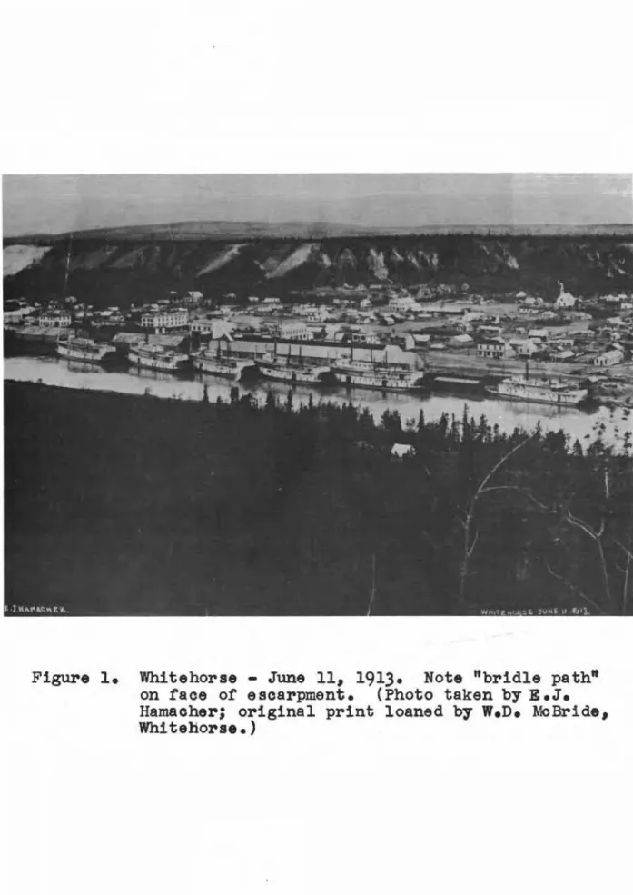
feet back from the edge of the escarpment. With the exception of this meadow, which was grass covered, the whole top surface of the escarpment was covered with a moderately dense growth of pine and spruce and light underbrush that gave it a park-like appearance. Preparing the meadow as a landing strip necessitated clearing off a few willows and small pine on the approaches. It is said that in the spring of some years, water lay for short periods on this meadow. A trail (known locally as the "bridle path") had existed since about
1900
up the face of the escarpment from the town below (Fig. 1). It was very steep and was used mainly as a footpath although horses could be ridden up it. At the top of the escarpment, the trail connected with roads leading to the airfield and to mines and lakes to the west.It was not until
1927,
however, when the Yukon Airways and Exploration Co. Ltd. was incorporated, that commercialaviation got its start. Klondike Airways Ltd. began operations in
1928
initiating air mail service to Mayo. In1929,
it was announced by the Hon. Charles Stewart, Minister of the Interior, that ample land had been set aside (at Whitehorse) for aviation purposes. Some of the land required for the airfield was donated by the White Pass and Yukon Route. The sum of$1,000
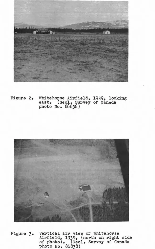
collected by subscription from local residents at this time was used to clear some brush and level off parts of the airstrip. Additional clearing, though not extensive, was carried out adjacent to the airstrip during1930
to1936.
Some gravel (decomposed granite) obtained nearby was used to leval off bumps and hollows on the grassy meadow (Figs. 2 and3) •
. The White Pass and Yukon Route began air operations from Whitehorse in
1935
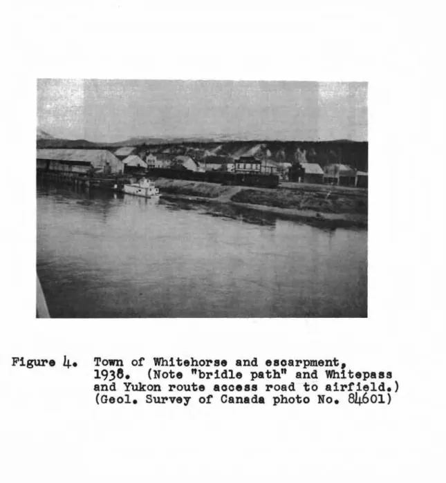
flying to Mayo and Dawson City. The main access road to the airfield was by way of Puckett's Gulch. However, the White Pass Company constructed a road about1937,
on the face of the escarpment near the old trail to provide easier access to the airfield (Fig.4).
In
1935,
on recommendations by Mr. A.D. McLean, Department of Transport, ヲッャャッキゥョセ a survey flight in the Yukon, a ァッカ・イョセairport property (see Plan No. F.B.
21863,
Legal Surveys and Aeronautical Charts Division, Dept. of Mines and Technical Surveys, Ottawa) and improvements to the landing strip. Mr. Jeckell, Controller for the Yukon, reported in1936
that "the ridge existing near the centre of the landing strip was removed and the dip towards the south end of the field was filled.Minor bumps and hollows were graded to uniform level for a length of
2,800
feet. The landing strip had been previously surfaced to a width of forty feet. This was widened to80
feet. The surfacing material used was a fine decomposed granite which was raked and rolled".During
1940,
the British Yukon Navigation Co. Hセィゥエ・Pass and Yukon Route subsidiary) had lengthened the runway some-what and improved the grades by hauling fill material from the east side of the cleared area, which was at a higher elevation, to a low spot about the centre of the runway. They also had erected a hangar on the northeast side of the existing cleared area and one or two small buildings セ workshop, office bUildings,
etc. - were located along the east edge of the airstrip.
It was in
1941
that the first major construction at the airfield took place. During the winter of1940-41
the Department of Transport drew up plans and made arrangements for a relatively large construction program to be carried out during the summerof
1941.
This work included: .(1) Construction of a stab1lized runway about
5,900
feet long by
150
feet wide and associated taxi strip east of the runway(ii) cッョウエイオ」エゥッセ of a road up the face of the
escarpment. The road to the airport by way of Puckett's Gulch was unoatisfactory because of steep grades and tho difficulty of keeping it open during winter and spring months
(iii) Erection of several buildings セ residences, offices, etc., on the east side of the field
(edge of the escarpment). The east side was chosen as the building area because it was close to the access road up the face of the escarpment, was convenient to a water supply from the YUkon River and meant a shorter connection to power facilities in the town of Whitehorse
(iv) Construction of a water supply main from a pump house at the Yukon River, up the face of the escarpment to the building area
12
-(v) Clearing and grubbing of trees and brush fram the proposed site except for a fringe along the edge of the escarpment.
This work was carried out by the White Pass and Yukon Route under contraot to the D.O.T. during 1911-1-42.
Much of the fill required on the runway was borrowed from the building area to the east. Other fill. material was removed from cuts along the line of the runway, namely, at the south and north ends. Difficult working conditions were encountered over the whole field owing to the existence of blow sand which was so clean and free from humus that it was impossible to fertilize and got a catch of grass. At a meeting on 17 June 1941, the Department of National Defence (Air Force), Aerodrome Development Committee, British Commonwealth aゥセ Training Plan and Home War Establishment Plan recommended that the runway and taxi strip be hard surfaced with a bituminous coating. It was considered advantageous to do this because Itof the arid soil conditions and extreme dust
nuisance existing on this sitelt •
The construction of the water line up the face of the escarpment just south of where the access road struck the crest of the escarpment proved to be a very difficult and costly
operation because of the loose soil (sand) that was encountered. The line was laid about 8 feet deep in an open trench and then backfilled. This required a very large excavation to prevent sloughing of the loose mnterial into the trench because lumber, which was scarce and expensive, could not be used for shoring the walls of the trench.
A gravelled cross runway NE-SW was also constructed. To get suitable grades on this strip a 10. to 15-foot cut was made through a knoll of silt at the southwest end. A wet swamp was partially filled at the extreme southwest end to complete this runway.
With the entry of the United States into the world conflict and the danger of invasion of Alaska, military air
traffic increased tremendously and early in 1942" the U.S. Ferry and Transport Command recommended additional expansion of the existing airport and facilities. The construction, as requested by the United States, was to be carried out by Canadian contractors under D.O.T. supervision. This work consisted mainly of the
erection of hangars" barracks, warehouses, workshops, etc., and the installation of water services including lines, pumphouses and a 100,OOO-gallon reservoir at the northwest corner of the field, with a few buildings, barracks, garages, etc. and a 150,OOO-gallon reservoir to be erected on the east side. Water supply for the American section at the northwest corner of the field was obtained from springs nearby (to the north at, or near Baxter's Gulch)o
During the sumqer and fall of
1942
open drainage ditches were excavated to drain that section of the field west of the asphalt runway and adjacent to the cross runway, the drainage being direoted to Puckett's Guloh to the north. Some trouble had occurred during the spring on the southwest end of the oross runway where frost action in the saturated soil softened the grade through the cut in the silt bank. There had been little or no airfield drainage work carried out the previous year since the sand provided a pervious cover over the field allowing any surfaoe キ。セ・イ to soak away.Septic tanks and tile fields were laid for disposing of sewage in the east side building area (Canadian). Six units were installed, four of which were approximately 100 feet from the edge of the esoarpment. Septio tanks and tile fields were also used in the American seotor at the northwest oorner of the field.
During the winter of
1942-43
and early spring, therequests from the U.S. Government for expansion of the airfield and oonstruction of additional faoilities increased to suoh an extent that an agreement was made at a meeting of U.S. and
Canadian representatives on
18
May1943,
whereby U.S. authorities would assume responsibility for any unfinished oonstructioninoluding oonstruotion initiated by Canadian authorities as well as the new oonstruction requested by the U.S. Government. Thus, all major oonstruotion on the airfield and in the surrounding area was carried out by U.S. military and oivilian agencies from the spring of
1943
to the spring of1945.
This work inoluded the oonstruction of a ooncrete N-S runway, ooncrete taxi strips, large hangars and an extensive development of the U.S. base (barraoks, workshops, offices eto.) all on the west side of the airfield. In addition, drainage of the airfield area was attempted with the installation of perforated wood and metal pipes and olosed systems along the west taxi strip and oonorete runway, all draining to Puckett's Gulch where the water spilled out into the gulley. Storm sewers were also
installed through the west oamp area, partioularly around the large hangars where foundation trouble was enoountered with the saturated silt on which the buildings were oonstruoted. These lines tied into the airfield drainage lines running to Puckett's Guloh. Domestic sewage from the west oamp was carried in 8
sanitary sewer down Puokett's Gulch to conneot with the sewer
system (construoted by the United States) in the town of Whitehorse. Inspection of the sewage disposal system in the east
building area in
1944
by D.O.T. representatives showed that the septio tanks and disposal fields were not satisfactory because:(8) the fine alluvial silt in the airport building area limited the effectiveness
MセM
(b) the cold climate resulted in slow bacterial action in the septic tanks, and
(0) the increase in personnel had in some instances oaused overloading of the existing sanitary facilities.
Subsequently, a colleoting sewer system was designed by the D.O.T. conneoting by means of a drop manhole and outfall sewer down the face of the esoarpment near the top of the acoess
road to the U.S. system of sanitary sewers in the Town of Whitehorse. At the same time, the R.C.A.F. drew up plans for a water
distri-bution system for the east side to be oonneoted into the U.S. distribution system on the west by means of a water-main skirting the north end of the airfield. The water line from the Yukon
River up the face of the escarpment to the east camp and the septio tanks and tile fields for sewage disposal were therefore abandoned. Some oonfusion existed as to who was to do the work, the D.O.T. or the R.C.A.F. However, the Bennett and White Construction Co. Ltd. carried out the construction of both the sewage and water
supply systems under contract to the D.O.T. The work was completed early in
1945.
It was recognized early in
1945
by both the D.O.T. and the R.C.A.F. that existing drainage faoilities on the airfield were inadequate. Drainage of the airfield during the summer wassatisfactory when moisture was able to drain away through the sand and gravel. During periods of sudden thaw, however, in the winter and spring months when fairly extensive runoffs occurred before the frost was out of the ground, water accumulated in same areas, notably between the concrete taxi strip and runway adjaoent to the cross runway, and icing occurred where runoff water found its way aoross the taxi strip and runways. In addition, where outs were made through the higher land adjaoent to the ooncrete taxi strip and the cross runway, seepage water from these silt knolls caused further icing and also provided ideal conditions for frost action which heaved concrete slabs as much as
4
inches.In March
1945,
therefore, the North west Air Command, R.a.A.F., Edmonton, submitted a comprehensive outline ofrecommended major improvements to the Whitehorse aerodrome.
This brief included major repairs to runways, taxi strips, etc., as well as drainage improvements at an estimated total oost
ot
$2,114,879.
The proposed plans for drainage were as follows: (i) advantage to be taken of looal topography
wherever field clearances would allow to install open interceptor ditches on the up-grade side of all traffio carrying areas
(ii) where field clearances were in effect perforated pipe was to be installed and backfilled with porous material at the bottom of all troughs or low spots so that
surface water could be led to them
(iii) on side slopes a porous drain cover to be installed on the up-grade side of the pavement to intercept any flow onto the pavement
(iv) all pipe to have a minimum cover of 8 feet to protect against frost damage, and
(v) the existing inadequate American drain along the concrete taxi strip was to be salvaged and replaced with a larger capacity perforated pipe buried at least 8 feet below ground
level to ensure interception of all seepage water and to protect 。ァ。ゥョウセ frost damage.
The total cost of this drainage was estimated to be about $213,000. Following discussion at previous meetings the Aerodrome Development Committee of the Department of National Defence (Air Foroe) at a meeting in June
1945
recommended that only sealing operations to runways and taxi strips plus such drainage as was required along the concrete taxiway be undertaken by the R.C.A.F. Construction Maintenance Unit, at a cost of approximately $470,000.It was not thought feasible to carry out the large construction program as proposed by North West Air Command since it was not known whether the airfield would be of continuing value. Specifi-cally, with regard to drainage, clearances were so restricted on the field that in many cases open ditching could not be utilized.
aエエ・ュセエウ to drain the storm water by offtakes along the low side (east) of the field would also be restricted by the town of
Whitehorse, the escarpment, access road, and railway requiring extensive, and thus expensive, piping of this water from the field to existing bridges and culverts on the railroad.
U.S. military traffic was reduced considerably when the War ended in
1945
and the American base (west side) was turned over to Canada. Construction carried out during the War on the airfield and associated facilities by American forces andoonbr-ao't or-s wa s on a "piecemeal" basis. When Mr. W.J. Johnston of the Department of Public Works inspected the buildings and services at the American base prior to acceptance by Canada he reported, with regard to the water and sewage installations, that the IIsitua tion was very confused with no proper plan of complete
16
-system". Similarly, little was known regarding construction of the concrete runways and taxi strips, drainage, etc., i.e., the kind of subgrade material used and location and types of drain pipe.
The Department of Transport carried out a survey of water and sewage installations during the latter part of 1945 and a plan of the oomplete airfield showing all the installations was oompleted in February 1946 (see Department of Transport,
Civil Aviation Division, Plan No. R-YU-18).
After the withdrawal of American forces from the area in 1945, the R.C.A.F., who had operated from the east side of the camp during the War, took over the base on the west side of the field. Subsequently, in the fall of 1946, the east side area, with the exoeption of a few bUildings, was turned over to the
D.O.T. who controlled operations at the field from that time until late 1947. From 1947 until July 1958, when the D.O.T. again took over operation and maintenance of the airfield, the R.C.A.F. had jurisdiction over the airport at Whitehorse.
The D.a.T. maintenanoe staff had difficulty in keeping the water and sewage services operating during the winter of 1946-47. With the decrease in personnel at the east side camp, several buildings were not in use - particularly in the southern end - and consequently, during the severe cold weather many
lines froze. Continuous maintenance of service lines was necessary. Maintenance of utilities (sewer, water and power) and
roads, eto., was again of concern during 1948-49 for evidently neither the D.O.T. nor the R.C.A.F. had the staff to carry out the work which was urgently required. For both organizations to set up maintenance units and facilities meant duplication of services. Ultimately, the R.C.A.F. took over maintenanoe of the airport because they were official operators of the field.
Plans for drainage improvements, in an attempt to alleviate serious sloughing on the face of the escarpment and generally poor airfield drainage conditions, were submitted by both R.C.A.F. and D.O.T. staff to their respective headquarters 1.n 1948 and 194.9. The cause of the escarpment problem was
attributed to water seepage from swampy areas west of the air-field and it was proposed to divert this water by deep underground drains "along the Alaska Highway and on the airfield to a closed drainage system to Baxter's Gulch.
A few hand borings made by D.O.T. personnel in 1949 and a few test pits dug with excavating equipment by the R.C.A.F. in 1950 seemed to indicate a "saucer-shaped" depression under the sand layer on the airfield leading water across the field to the edge of the escarpment.
No corrective measures were started until mid summer of 1950. At that time, existing airfield drainage lines
(constructed by U.S. forces) were cleaned out, subsurface drains and manholes were installed along both sides of the cross runway west of the concrete taxi strip, and a deep ditch was excavated along the Alaska Highway which carried water to
storm sewers through the west camp (R.C.A.Fo). A ditch was excavated due south to the edge of the escarpment from the
junction of the concrete taxi strip and runway at the south end of the field to drain the south half of the west edge of the taxi strip, and grading of slopes and shoulders along the concrete runway and taxi strip to direct surface runoff into the existing drainage channels was carried out. This work, started in 1950, was completed in 1951 by Poole Construction Co. under contract to the R.C.A.F. At the same time, the storm water sewer, previously emptying into Puckett's Gulch, was
reconstructed so that water is now carried north of the airfield in a buried line to the bottom of Baxter's Gulch.
Considerable leakage of the water lines in the east oamp was reported in 1950. The whole system was tested and leaks were repaired with new lengths of pipe by recaulking joints and by replaoing valves, etc. Dead end lines were eliminated where possible. The major water-main leaks were located at the south end of the camp. The work was carried out by Northern Construction Co. and J.W. Stewart Ltd. All repairs made and all revamping of lines carried out are indicated in detail on a "Plan Showing the
Water Distribution System and Sewer System on East Side of Whitehorse Airport" as filed in the Department of Transport, Civil Aviation
Division, Architectural Section, under No. F3320.
Since 1951, no major construction other than routine maintenance work has been carried out at the R.C.A.F. Station, Whitehorse.
18
-PART FOUR
SLOUGHING OF THE ESCARPMENT;
The access road to the airport, constructed in
1941
by the White Pass and Yukon Route under contract to the Department of Transport, carried heavy traffic, mostly military but some civilian. Minor sloughing had occurred on the road each year fo]lowing construction, but was not extensive enough to warrant major repairs. It 1s reported by Whitehorse !told timers" that mud flows, similar to those that occur now, did not exist on theslope previous to this time. In the fall of
1944,
however, the road was closed for about one month by the R.C.A.F. to carry out maintenance and repair work on "the sandy portion of the east hill" •Mr. H.V.G. Wheeler (then Department of Transport airway
engineer at Whitehorse) reported to D.O.T. district headquarters at Edmonton in August
1948
that storm water from the airfield had recently flowed down the face of the escarpment (A, Fig. 17) through a culvert installed by the R.C.A.F. that spring in the road around the north end of the field. The culvert was (and is) located just north of the northeast end of the cross run-way. Although there was not a large quantity of water it washed a great deal of material down the slope silting up portions of the cemetery, some yards, and one basement. Mr. Wheeler also reported that "this water came from a point at the edge of the hill where the road around the airport had been washed outseveral springs to the writer's knOWledge". At the same time the storm water sewer emptying at the head of Puckett's Gulch had undermined itself and the sanitary sewer. The sanitary
sewer consequently broke, emptying raw sewage down the slopes and eroding the head of the gulch. Other minor slides occurred along the face of the escarpment during this year. Mr. Wheeler's
observations were passed on to DoO.T. headquarters in Ottawa this same year.
In a detailed report (July
1949)
to the Director of Air Services, Department of Transport, Ottawa, the occurrence of two serious slides was described by the District Controller of Air Services, Edmonton, and イ・」ッャセョ・ョ、。エゥッョウ suggested for corrective drainage, exploratory field work to determine the profile of the relatively impermeable strata underlying the surface sand layer on the field and the possibility of calling in a consultant.The most serious slide had occurred adjacent to the n.O.T. garage
(B,
Fig.17)
where the top of ehe bank was within30
feet of the building with indications (fissures) of further slides. The second major slide occurred at the point (C, Fig.17)
where the outfall sewer dropped down the escarpment. Other minor slides had occurred along the length of the escarpment overlooking theFurther slides were reported during the summer and fall of
1949
which blocked the access road for short periods. Also, seepage water flowing from the interface of the sand and silt layers caused icing of the road in late fall with the result that the R.G.A.F. finally closed the road. This created some ill feeling among the local people who cleared the debris off and traffic continued to use the road bypassing the barricades. The R.G.A.F. recommended closing the road permanently since large cracks were opening at the edge indicating further slides would occur.In
1950,
further sliding of the slope around the outfallsewer necessitated cribbing and backfilling to prevent freezing and further damage to the line. The occurrence of more slides
(D, Fig_
17)
along the escarpment was endangering several dwellings in the Town of Whitehorse at the base of the slope. A preliminary engineering investigation by D.O.T. engineers indicated the need for considerable stUdy of the problem before remedial measures could be taken.Extensive slides occurred along the escarpment in
1951.
The access road was continually blockAd and continuous maintenance by the R.G.A.F. was required to keep it in service. R.G.A.F.vehicles no longer used this road as they travelled from Whitehorse to their base by way of the Two Mile Road north of the airfield.
Goncern for the safety of the buildings at the top of the slope and the condition of the access road resulted in an inspection trip by representatives of the D.O.T. and the R.G.A.F. who submitted a joint report in September
1951.
Remedial measures such astrimming the slope were not considered feasible because of the proximity of the buildings to the edge of the escarpment. It was recommended that an exploratory program be carried out to determine the location and contour of the impervious layer Which, it was
thought, was channelling water to the face of the escarpment. The most serious slides occurred
(A
andE,
Fig.17)
in19.53
when large quantities of "soupy" material flowed down into the Town of セヲオゥエ・ィッイウ・ causing considerable damage to private property. Light snowfall (and thus deep frost penetration) and excessive rainfall in the preceding winter and during the spring respectively were thought to have been a major contributingfactor. Sloughing and mud flows, varying in degree of seriousness, have occurred each year since, on the face of the escarpment (F, Fig.
17).
Several auger holes were bored on the airfield by D.O.T. personnel in
19.54
and the results of this investigation werereported by Mr. E.B. Wilkins, District Airways Engineer, Department of Transport, Edmonton in
19.54.
In19.5.5
a more detailed examination20
-of the escarpment was carried out by Mr. S.J. Brander -of Department of Public Works, who made a topographic survey of the slope and put down a number of test borings along the edge of the escarpment.
Both Department of Transport and Public Works engineers, however, suggested that a much more detailed program was required to establish definitely the contours and soil types of the material underlying the whole airport area. As a result, a comprehensive program of test borings was dravm up by the Department of Public Works to be carried out during the summer of 1956 by a private contractor. The work covered the drilling of about 65 holes of which three would be to a depth of 250 feet as suggested by personnel of the Geological Survey of Canada. This program was held in abeyance pending recommendations of the Construction Subcommittee of the Advisory Committee on Northern Development of the Department of Northern Affairs and National Resources.
At a meeting of the Advisory cッセセゥエエ・・ on Northern Development in November, 1956 approval was given for a
full-scale study of the history of the development on the Whitehorse escarpment. This would include the collection of information on the condition of the escarpment prior to construction and a
review of all developments that had taken place since then.
This stUdy, begun in January 1957 by the authors of this report, pointed out the need for an exploratory borings program to determine the extent of the silt deposit over the whole air-field. In September 1957 the R.C.A.F. made a number of borings (45) at intervals of 500 feet over the airfield. The extent and depth of the surface sand deposit was thus delineated and a general picture of the subsurfaoe elevation of the silt was obtained.
Details of the contours of the upper surfaoe of the silt were, however, lacking in several oritica1 areas.
To obtain the desired information, a more extensive borings program was required. In September 1958 the firms of Warnock,
Hersey and Company Ltd. and G.S. Eldridge and Company Ltd., together oarried out, for the Department of Pub1io Works, a study which
consisted of boring 。ーーイックャュZZセエ・ャケ 520 holes on a grid pattern of 200 feet over the airport.
In June 1958 an investigation concerned with the feasibility and cost of reforestation of the escarpment slope and the obtaining of a grass oover on the airfield was conducted by Mr. W.M. Stie11 and Qセセ P.H. Jones, Forestry Branch, Department of Northern Affairs and National Resouroes at the request of the authors of this report. The results of this study are described in their report dated
PART FIVE DISCUSSION
A review of pertinent aspects of the development of the Whitehorse airport is contained in the following sections.
Observations made by the authors during visits to the site, information collected from several sources, and the results of tests carried out are included. Finally, the probable causes of the escarpment instability are discussed.
(1) The eウッセセ・セセ
In contrast with what is shown on old photos (Figs. 1 and 4), whioh show the face of the esoarpment in a relatively well-wooded condition, the vegetation today (Fig. 5) has been totally destroyed or at least badly disrupted on that portion from the southern extremity of the building area on the top of the esoarp-ment to approximately a point in line with the oross runway or about 1,000 feet north of the northern limit of the building
area. The total length of escarpment involved is about 4,000 feet. It oan be seen from Fig. 1 (June 13, 1913) that those
parts of the slope which then had no trees or standing vegetation had a surfaoe cover of grass, which no doubt, is the same as the grass cover existing on similar slopes in the vicinity today. It will also be noted that what appear to be mud flows were even
then taking place on the face of the escarpment but were minor and much less extensive cOTIlpared to those occurring at the present time.
An examination of portions of the escarpment slope, not covered by mud flows, was made in July 1954 for the Yul{on Forestry Division, Department of Northern Affairs and National Resources. This indicated that the area had been cut over and burned just prior to the establishment of the present stand of vegetation. Samples of the existing tree growth (white spruce and lodgepole pine) were examined and found to be betweon fifty and sixty years of age. A more detailed report of vegetation conditions on the escarpment face is given in the report by W.M. Stiel] and P.R.
Jones, Department of Northern Affajrs and National Resources, dated August"1958 (see Appendix C).
Each year, in the spring, with the melting of the snow and thawing of the ground, a Itsoupyll mixture of sand and silt flows down the face of the escarpment sur-r-oundLng homes at the base and running as far as 500 to 1,000 feet along the streets
22
-of the town -of Vfuitehorse. A large part of the cemetery at the west end of Main Street has been covered, drainage ditches have been filled, flows have covered the railway Y-yard at
its northern end, and are encroaohing at its southern end, and two 011 tanks adjacent to the railway Yare surrounded by Itmudn •
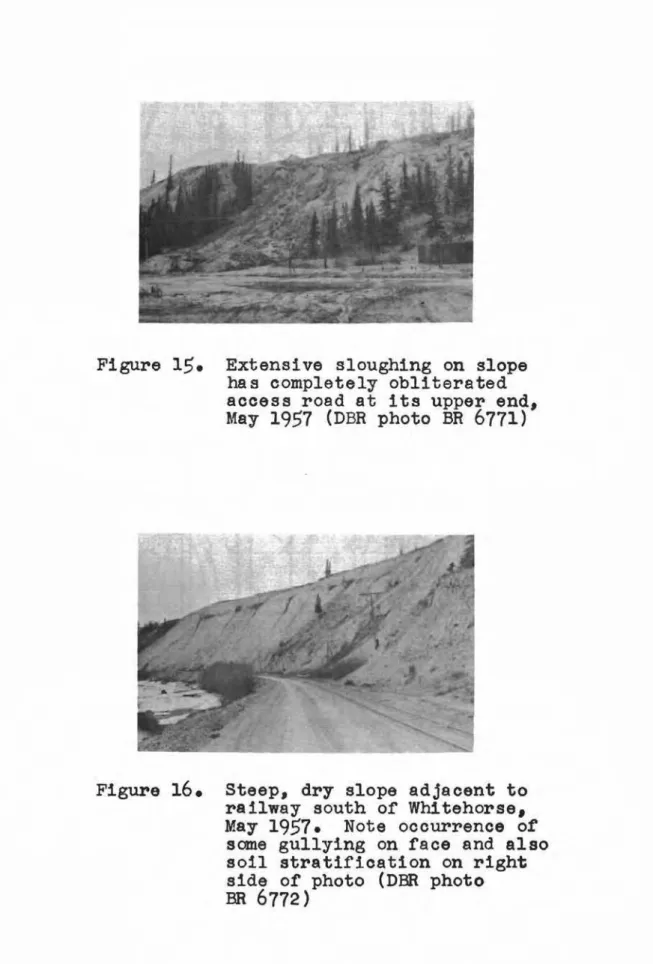
The aocess road on the face of the escarpment (whioh has been closed for several years) is completely obliterated at its
upper end and provides a path for the mud flows above its lower seotion, directing them down onto Main Street and the adjacent areas of town.
At the time of the junior writer's visit (29 April to
10
May1957)
sloUghing of the escarpment was taking place alongthe whole face. Large drifts of snow still remained at the tops of two of the large scalloped portions north of the building area (Fig.
9).
The face of the esoarpment, wherever flows were occurring, was found to be frozen. Melt water from the snow-drifts and the frozen face picked up material as it trickled down the slope. The soupy mixture dammed up at obstructions on its way down the slope until a sufficient quantity accumulated so that 2 or3
cubic feet of material would then slide as a mass increasing in velocity and aided by the slippery surface of the frozen face. By the time it reached the bottom of the slope,the material was flOWing in a relatively large stream which decreased in velocity as it spread out on the flats below. At night, because of cooler air temperatures, the flows diminished greatly, in some cases ceasing altogether, indicating that this first sloughing was caused primarily, if not totally, by melt water.
The top edge of the terrace has been badly affected by erosion notably near the Department of Transport garage at the northern end of the building area and also for a stretch south
and north of the outfall sewer line down the face of the escarp-ment. At the garage, gullying has proceeded to within 30 feet of the building, and the edge of the escarpment behind the Department of Transport fire hall and barracks has sloughed to within
10
feet of the buildings.Refuse has been thrO\vn over the edge in two or three
places. Ashes and cinders have been dumped behind the Department of Transport barracks and waste oil plus other material such as automobile axles and springs, have been cast over the edge near the garage.
Surface run-off from the airfield had caused gullying in two places adjacent to the east end of the cross runway (one being opposite the culvert through the road to the west side of the
of material down the slope to the town. A shallow ditch had been dug (by hand) to the face of the escarpment, at a point just south of the outfall sewer line, which drained surface water from a low spoto This, although dry at the time of inspection, had caused the bank to erode back
10
to15
feet and had also carried a good deal of material down the slope.The outfall sewer line serving the building area at the top of the escarpment has had to be suspended above the face from steel cables tied to towers - one at the top and one at the bottom of the slope. Power lines also have been supported or
strengthened by steel cables. This has been done in an attempt to prevent breakage of these lines when caught by materia1
sloughing down the slope.
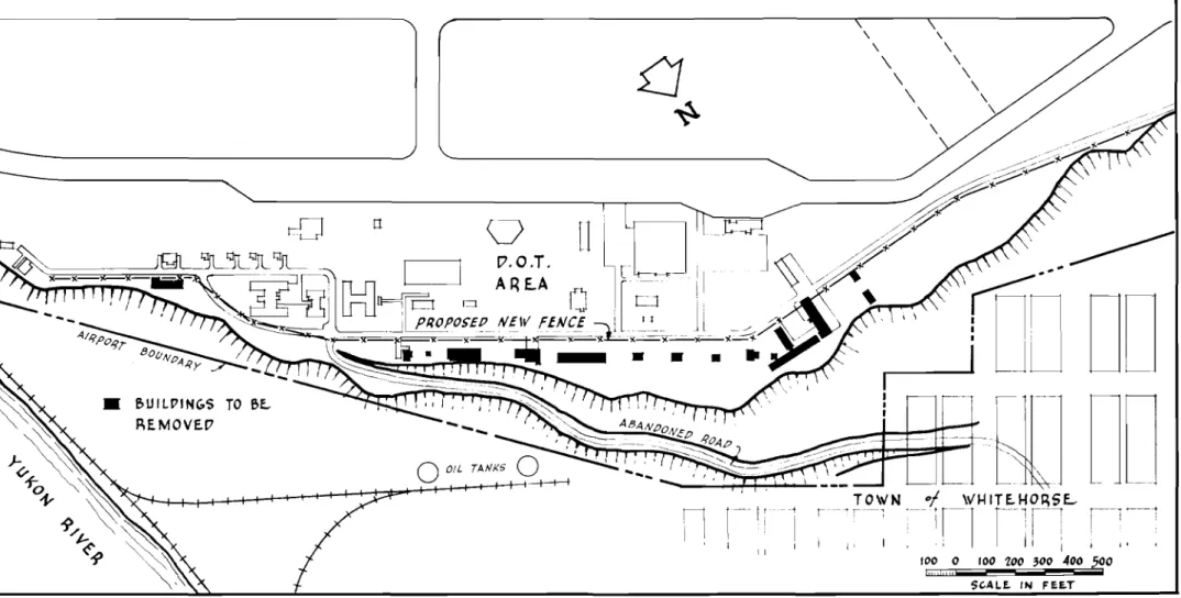
At two or three places along this disturbed section of the escarpment, the silt and sand layers stand with almost
vertical faces and are bone dry with only minor sloughing of the dry material taking place. At no place on other escarpments in the Whitehorse area (down river and across the river from town) were mud flows evident similar to those on the airfield escarpment, although dry natural sloughing has taken place on most of the
slopes.
Cracks along the edge of the escarpment and leaning trees indicate that further soil movements are to be expected at different locations along the slope.
(2) Escarpment Soils
The escarpment consists almost wholly of a very fine sandy silt or silt which appears to be well bonded and is quite stable in the dry state as shown by the almost vertical faces standing on some sections of the slope. It is stratified, as a rule, but appears to be homogeneous throughout. Some of the strata have undergone some distortion.
Undisturbed samples of the silty material were obtained from a borehole put down by the junior writer (May
1957)
near the edge of the escarpment behind the Department of Transport residences. The samples were taken just below the intersection of the silt and sand layers at a depth of about11
feet. Examination showed that fine sand layers(1/16
to1/4
inch thick) separated the silt strata which were from1/4
to 1 inch thick. Distortion of a 3-inch section of the silt and sand strata occurred about6
inches below the sand and silt intersection. The junio!' writer also examined a dry, vertical slope along the railway just south of the Y-yard andthese points, the stratification was seen to be layers of silt, from 1 to
3
inches or more thick, separated by very thin layers of fine sand. No evidence of clay layers or strata was notedin these sections.
Overlying the silt and extending to the surface of the airport is a layer of clean, medium to coarse sand which varies
in depth from
4
to30
feet. In an 。エエ・ョセエ to alleviate the dust nuisance, gravel was spread up to 6 inches in depth over virtually all the infield area as well as on the other セ・」エゥッョウ of the field.No preliminary investigations were carried out, prior to construction of the airport, to determine the extent of this
surface sand layer, and with the grading of the top of the plateau and moving of soil back and forth, all indications of original conditions have been obliterated. Portions of the concrete taxi strip and the west end of the cross runway were constructed in cuts made through silt knolls on the west sid3 of the field. Aorial photos taken during the war show this construction taking place and seem to indicate that these knolls tapered off between the taxi strip and the concrete runway. It is said that the silt came to the surface near the southern end of the field. Some material from the cuts on the west side was wasted in the area south of the runways.
It was thought important that the depth and extent of this sand layer on the airfield should be determined so that an intel-ligent appraisal of possible causes of the slope stability problem could be made. Therefore, a boring program was initiated during the summer of
1957
to determine the subsurface contours of the silt. This work was kindly carried out by R.C.A.F. personnel at the Whitehorse base during September1957
The results of this exploration work plus records obtained from boreholes put down by the junior author in July
1957,
byDepartment of Public Works personnel (S.J. Brander) in May
1955,
and by Department of Transport personnel (E.B. Wilkins) in June1954
were then plotted to determine the upper contours of the silt deposit. The extent of the sand layer was thus defined but more detailed information was required to define the silt-sand interface. Subsequently, a more extensive boring program was carried out in September1958
by the firms of Warnock, Hersey and Company Limited and G.S. Eldridge and Company Limited under contract to theDepartment of Public Works. A contour plan of the silt surface (Fig. 18) was dravm from the detailed information obtained from approximately 520 holes drilled on the airport. It appears from an examination of this plan that the main cause of the escarpment
sloughine is due to surface waters falline on the runway and east side building areas and not to a deep-seated source of water under the airport as had been suggested. Although ponding of water may occur on the silt surface at one or two isolated locations, no direct connection between these and the areas of trouble on the escarpment face can be established.
Add! tional interesting information is LnoLude d in the consultantsr'report but only relevant material has been included in Appendix D which is an aocount of the work carried out.
An undisturbed sample of the silty soil obtained by Mr.
R.F. Legget in
1954
was sent to the Engineering Laboratories, Bureau of Reclamation, U.S. Department of the Interior, Denver, Colorado for microscopic analysis. The sample was found toslake rapidly in water to a loose silt but when dry was coherent but weak and pulverulent. Under the microscope, the analysis revealed: Uthe matrix is composed of angular particles in very fine sand and silt sizes. Angular particles of fine sand are distributed sparsely through the matrix. The grains constituting the bulk of the matrix are about
0.015
mm. in diameter. Theinterstices are partially or completely filled by clay and clay. like minerals. The particles of very fine sand and silt are
predominantly calcite, dolomite, quartz, feldspars, and leucoxene. Particles of amphiboles, epidote, Zircon, and miscellaneous other minerals are present in small amounts. The particles of fine sand are feldspars, quartz, chalcedonic cherts, shale, limestone, and granitic rocks. The interstitial material is a mixture of micas, hydro-micas (illite), and small amounts of a morrnmor-f.Ll.onof.d ,"
Soil classification tests were carried out by the Department of Transport and the Division of Building Research Soil Mechanic s Laboratory on sample s obt'afne d in
1954
and1957.
A summary of the soil test results and curves of grain size distribution limits are shown in Appendix E. The tests show the material to be a light grey, inorganic silt, with some(5
to20 per cent) fine sand and clay and of low to medium compressibility. The grain-size curve of one sample (XY#2), which deviates
some-what from the limits of 11 others, is seen to lie almost wholly within the silt range and consist predominantly
(75
per cent) ofcoarse size particles.
The layer of clean, medium to coarse sand which covers the airfield is very permeable and allows water to percolate downward rapidly. The underlying silt, however, is relatively impermeable; samples tested in the Division of BUilding Research Soil Mechanics Laboratory shgwed that the permeability coefficient of the silt is about
8
x10-
centimetres per second (i.e. almost impermea[)J.e).(3) Sewage Disposal
Soptic tanks and disposal fields installed in the east side building area in
1941
did not function properly and were abandoned in1944
when a collecting sewer system was constructed. It is not known whether the septic tanks were actually removed. The collectine sewer system is connected to the town of セセゥエッィッイウ・26
-sewer by means of an outfall line down the escarpment near the south end of the bUilding area. It was very difficult to
install th is outf'a 11 line and sloughing of the slope ha s caused a great deal of trouble each year since. The pipe, which was previously buried 8 feet deep is now exposed and is supported by steel cables from two wood towers, one at the bottom and one at the top of the slope. The only building at the present site served by a septic tank is a one-family dwelling adjacent to the guest house at the extreme south end of the area. No
difficulties have been reported with the present sewer system, other than those encountered on the outfall line with sloughing of the slope material; it is believed it has contributed little to the erosion of the escarpment face.
(4)
Water SupplyA water main constructed in 1941 from a pumphou se at the Yukon River up the face of the escarpment at the location
of the present outfall sewer line supplied water to the east camp.
In QYセNL a line from the American base on the west side, which
is supplied by a pumphouse on McIntyre Creek, was constructed around the north end of the field and the main from the Yukon River was abandoned (pieces of エ「セ 2 1/2-inch pipe can be seen on the slope).
Minor leaks have occurred in the system nearly every year due mainly to freezing of lines, but these have generally been repaired without delay. A large maintenance program was carried
out in 1950 when many leaks were reported. The whole system was thoroughly checked and sections of the line excavated and replaced with new pipe. The most serious leakage occurred in the mains
just west of the top of the access road where pipes had frozen and cracked (see Plan No. F3320 Department of Transport, Civil Aviation Division, Architectural Section). The existence of a valve on the water supply main to the east side at the northeast corner of the cross runway bas been noted on this plan. From this valve a 2-inch diameter drain line leads to the edge of the escarpment immediately above Main Street in the town of Whitehorse. The location of this valve and drain line should be verified and precautions taken to ensure no water loss occurs at this point. Had water leaked or been allowed to flow from this valve to the side of the escarpment, then it would account for much of the trouble -at this most critical point.