HAL Id: halshs-02975449
https://halshs.archives-ouvertes.fr/halshs-02975449
Submitted on 22 Oct 2020HAL is a multi-disciplinary open access
archive for the deposit and dissemination of sci-entific research documents, whether they are pub-lished or not. The documents may come from teaching and research institutions in France or abroad, or from public or private research centers.
L’archive ouverte pluridisciplinaire HAL, est destinée au dépôt et à la diffusion de documents scientifiques de niveau recherche, publiés ou non, émanant des établissements d’enseignement et de recherche français ou étrangers, des laboratoires publics ou privés.
Aurore Didier, David Sarmiento Castillo, Pascal Mongne, Syed Shakir Ali
Shah
To cite this version:
Aurore Didier, David Sarmiento Castillo, Pascal Mongne, Syed Shakir Ali Shah. Resuming exca-vations at Chanhu-daro, Sindh: First results of the 2015-2017 field-seasons. Pakistan Archaeology, Departament of Archaeology and Museums of Pakistan, 2017, 30, pp.69-121. �halshs-02975449�
1
Resuming excavations at Chanhu-daro, Sindh: First results of the
2015-2017 field-seasons
By Aurore DIDIER1, David SARMIENTO-CASTILLO1,2, Pascal MONGNE1, and Syed Shakir ALI SHAH3,
1 CNRS-UMR7041 - Archéologies et Sciences de l’Antiquité, Nanterre, France 2 University of Paris 1 – Panthéon-Sorbonne, France
3 Exploration and Excavation Branch, Culture, Tourism and Antiquities Department, Government of
Sindh, Karachi, Pakistan
Introduction
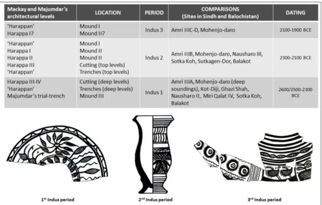
The Indus Civilization studies have seen major advances in the past decades that provided new insight into the settlement patterns, craft developments and socioeconomic organization of this major culture known as the first urbanization phenomenon in South Asia (Kenoyer 2014). While its undeciphered script, decline and legacy have been thoroughly studied in past, the most recent researches much focused on subsistence strategies and the impact of environment change in pre/proto-historical South Asia (see for example Madella and Fuller 2006; Wright et al. 2008; Fuller and Stevens 2009; Bates et al. 2016; Anindya Sarkar et al. 2016). However, crucial questions still need to be answered. One of the major challenges is indeed to better understand its origins and internal evolution over the course of six-seven hundred years (2600/2500-1900 BCE). Several major archaeological projects in Pakistan and India allowed subdividing what is generally called the “Mature Harappan period” into three sub-periods based on stratigraphical data and a detailed investigation on pottery and artefacts. These three sub-periods evidenced, for example, at Amri (Casal 1964; periods IIIA, IIIb, IIIC-D1), Nausharo (Jarrige 1996, 2008; Quivron 2000; periods II, III, IV), Harappa (Meadow and Kenoyer 2005; Kenoyer and Meadow 2008; Kenoyer 2008, 2011, 2014; periods 3A, 3B, 3C) or Dholavira (Bisht 1991, 2000, 2015; stages III-V), have been characterized by developments and changes in architecture and material culture most likely along with fluctuations in political and socio-economic organization and exchange networks. At Nausharo for example, each sub-periods of the Indus Civilization can be associated with a painted pottery stylistically different as it was demonstrated by G. Quivron from the stratigraphy of the site and its material assemblage which includes more than 4,000 ceramic vessels archaeologically complete (Quivron 2000). Quivron also noticed that the distinctive ceramic style of the first ‘Indus’ period identified in the levels of Period II at Nausharo existed in almost all the excavated Mature Harappan sites (Ibid.).
Nevertheless excavated sites in the Greater Indus Valley that provided a thorough documentation on this first period of the Indus Civilization (2600/2500-2300 BCE) are very few in number, particularly in Sindh for which the study of this period is substantiated by limited field-data. For many sites, those earlier phases are indeed deeply buried beneath more recent occupations dated to the subsequent sub-periods (2300-2100 BCE; 2100-1900 BCE) or post-Indus period (or both). At Mohenjo-daro, we know a posteriori on the basis of comparative analysis of pottery styles that the exposed architectural remains belong to the second and third periods of the Indus Civilization. The levels of the first Indus period have been reached only in the deep soundings dug by Mackay (Mackay 1938), Wheeler (Alcock 1986) or Dales (Dales and Kenoyer 1986). At Miri Qalat in Kech-Makran (Balochistan), a site excavated by the French team from 1990 to 1996, several meters of deposits dated to the first Indus period came to light, but unfortunately on a limited area due to the presence of a Late Islamic Fort nearby (Didier et al., 2012; Didier 2013; Didier et al., forthcoming). Other sites did not provide substantial data on the first Indus period or were too eroded such as Amri
1
2
in Dadu District, Sindh, where only pottery kilns have been uncovered for this period (Casal 1964; period IIIA) or Kot-Diji in Khairpur District, Sindh, where few ‘Harappan’ architectural structures2 have been excavated (Khan 1965). In Sindh, many sites buried beneath the sediments of the massive foodplains remain inaccessible to excavation while others have been damaged or destroyed by agricultural and/or industrial projects like Lakhan-jo daro. It is worth stating that the only site excavated in Pakistan that provided levels dated to the first Indus period on a very large scale is Nausharo where erosion and intensive gullying processes made possible to carry out extensive excavations (Jarrige 1986, 1988, 1989, 1990, 1993, 1996, 2008; Quivron 2000). Besides the discovery of several levels of dwellings built in mudbricks, Jarrige and his team excavated a large circular structure, a large portion of a surrounding wall equipped with a ramp, a portion of a monumental building edified with very thick walls and a big collecting drain in fired bricks connected to a water tank (Ibid.). If today many regions of the Greater Indus Valley became inaccessible to field-work, remain incompletely surveyed or to be explored, one can argue that Sindh often considered as ‘the cradle of the Indus Civilization’ represent the best area to develop new archaeological investigation on that subject.
Based on this observation, it also appears that one of the most sustainable methods to provide a better understanding of the formation of Indus cities and architectural and material achievements during the first period of the Indus Civilization is to select a site where these early levels could be largely accessible and to carry out extensive excavations. In 2015 the French Archaeological Mission in the Indus Basin started a new field-work in Sindh with permission and cooperation of Department of Archaeology and Museums, Government of Pakistan, and Culture, Tourism and Antiquities Department, Government of Sindh (Fig. 1). Through field studies combining both explorations and excavations along with a systematic comparison with the data collected by the French Mission in Balochistan, the goal of this project carried out in collaboration with Exploration and Excavation Branch, Karachi, Tourism and Antiquities Department, Government of Sindh, is to: 1) Re-examine the protohistoric chrono-cultural sequence in Sindh that needs improvements in key areas and better characterize the transition between the pre-Indus period and the Indus Civilization; 2) Bring further data on the local socio-cultural developments and inter-regional interactions with the 4th – 3rd millennia cultures from Balochistan; and 3) Provide new insight on the architectural and craft developments during the first period of the Indus Civilization (2500-2300 BCE). After re-examining the old published data and visited several sites in 2015, our Pakistani-French team selected Chanhu-daro in Shaheed Benazirabad District for the most extensive field-operations (Didier et al., 2015, 2016).
Why resuming excavations at Chanhu-daro?
Chanhu-daro is located south of the modern village of Jamal-Kirio on the Hazari Wah3 between the towns of Sakrand and Nawabshah (Fig. 2). The site has been discovered in 1931 by N.G. Majumdar, Assistant Superintendent of the Archaeological Survey of India (Majumdar 1934) and excavated during one field-season in 1935-1936 by the first American Archaeological Expedition to India under the supervision of E.J.H. Mackay who detailed the excavation results in a monograph published for American School of Indic and Iranian Studies and Museum of Fine Arts Boston (Mackay 1943). According to Majumdar (1934: 36), Chanhu-daro that comprised three ancient mounds roughly covered an area of about 6.3 hectares (300 m x 210 m), which is a “small site” in comparison with large cities such as Mohenjo-Daro, Harappa or Rakhigarhi.
2
At Kot-Diji, the ‘Harappan’ architectural levels excavated by F.R. Khan have also been dated a posteriori to the first period of the Indus Civilization from comparative studies of ceramics (Quivron 2000: 164).
3
3
Figure 1: Map of the protohistoric sites excavated by the French Missions since 1958 and major Indus
Civilization sites in Pakistan.
However, as mentioned by Mackay (1943: 9), the site is much eroded and should extent on a much larger area beyond the limits of the three mounds emerging above the level of the surrounding plain. Mackay’s stratigraphical sequence mainly established from extensive excavations in the visible part of Mound II4 and in a deep exploratory cutting5 embracing the south-western slope of Mound II includes four architectural levels ascribed to the period of the Indus Civilization: ‘Harappa I’ (the most recent one), ‘Harappa II’, ‘Harappa III’ and ‘Harappa IV’ (the oldest one). For the ‘Harappa II’ architectural level – which provided the most complete data - Mackay excavated buildings in fired bricks which are said to be grouped around streets in a planning system comparable to Mohenjo-daro (Ibid.: 38-39). He also evidenced a well-preserved system of drains and craft “quarters” associated with evidences of bead and seal making or metal tool manufacturing. Since then Chanhu-daro has been described in the archaeological literature as one of the most important craft production centres of the Indus Civilization (Wheeler 1968; Fairservis 1975; Allchin and Allchin 1982; Sher and Vidale 1985; Vidale 1989; Kenoyer 1999, 2014; Miller 2005; Wright 2010). In 1984, G.M.
4
Mound II was the largest and highest mound in Chanhu-daro as reported in Majumdar’s (1934: 36) and Mackay’s (1943: 1) publications.
5
4
Sher and M. Vidale carried out a survey to collect surface evidences of craft activities (Sher and Vidale 1985; Vidale 1988, 1989). They reported many concentrations of kiln-wasters, blades and cornelian waste flakes, evidences of chert and steatite debitage and shell working (Ibid.: 592-595). Since then, new studies on the material assemblages collected by Mackay at Chanhu-daro have been conducted (Miller 2005, 2014; Law 2011), but no excavations have been carried out since Mackay’s field-work. Perhaps of even greater importance, the architectural sequence of the ‘Mature Indus Period’ at Chanhu-daro established several decades ago and its material culture remained rather static in view of significant advances achieved in our understanding of chronological sequence of the Indus Civilization. Only the Jhukar occupation has been reinterpreted by H.J. Miller (2005).
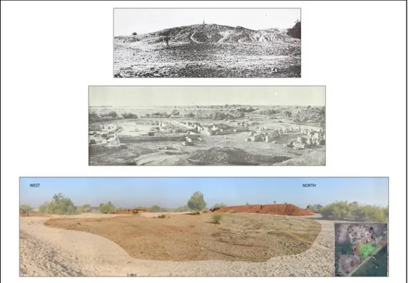
Figure 2: Aerial view of Chanhu-daro in 2017.
In his paper on the evolution on the Mature Indus pottery style, G. Quivron noted that Chanhu-Daro was “the most interesting site to corroborate the chronological framework of the
Mature Indus period of Nausharo” (Quivron 2000: 162). By comparing groups of ceramics published
as a whole in Mackay’s and Majumdar’s catalogues with the painted vessels from Nausharo, he clearly showed that the two sites “parallel each other in the stratigraphic provenience of their
ceramic assemblage” (Ibid.: 163). It is thus become possible to confirm that the “Mature Harappan”
phase at Chanhu-daro followed the same chronological subdivision into three periods comparable to those defined in other excavated sites (Ibid.) (Fig. 3). The architectural level ‘Harappa II’ – the best-preserved architectural level excavated in Mound II – can be related a posteriori to a settlement dated to the second period of the Indus Civilization from a careful re-examination of the pottery published by Mackay. Ceramics ascribed a posteriori to the first Indus period by comparisons with the pottery found at Nausharo period II, Amri period IIIA, Harappa period 3A or Miri Qalat period IV were evidenced in the trial-trench dug by Majumdar in Mound III, the Mackay’s trial-trenches dug in the uncultivated area on the north-eastern side of Mound II, the deepest levels of the Cutting dug in the south-western part of Mound II and few dispersed areas reached by Mackay in the northern portion of Mound II below the Harappa II architectural level6 (Ibid.: 163, figs. 8.A, 9) (Fig. 4).
6 The Harappa II architectural level corresponds to an occupation from the second Indus civilization period (Ibid.: 163, fig. 8.B)
5
Figure 3: Revised chrono-stratigraphical sequence of the Indus Civilization occupation at Chanhu-daro (Pottery
drawings after Mackay 1943: Pls. XXVIII.49, XXXII.7 and XXXIII.15).
Figure 4: Chanhu-daro – Map of Mound II (Harappa II level) and Mound III with locations of ceramic vessels
dated a posteriori from the first period of the Indus Civilization (After Quivron 2000: Fig.9; plans of architectures after Mackay 1943: Pls. III-IV).
6
However, numerous questions were still raised since few architectural remains associated with these ceramics have been described in the publications. The published data indeed mention very isolated portions of drainage channels, drains, walls in fired bricks and pavements that did not form a coherent plan and remain difficult to correlate, and upper portions of massive structures in mudbrick. Today the architectural remains in fired bricks excavated in the 1930s have totally disappeared due to erosion and recent brick recycling (Fig. 5). The schematic section of the site presented in Fig. 6 shows that what were called Mound II and Mound III belong to a strongly eroded single Mound whose greatest part is nowadays still buried.
This gives us the unique opportunity to reach directly and on a very large surface the earlier levels dated to the first period of the Indus Civilization and collect further data that help to better document the architectural and craft developments during the first Indus period still little-known in Sindh, and redefine the models of gradual evolution of urbanism in the Greater Indus Valley.
Figure 5 : Chanhu-daro – Mound II. Top: Mound II, from south, before Mackay’s excavation (After Mackay 1943: Pl. IX.b). Centre: Buildings from Harappa II occupation, from north-east (After Mackay 1943: Pl. XV.b).
Bottom: Location of Mound II (totally eroded) in 2015, from south-east.
Figure 6: Chanhu-daro - Schematic section of Mounds II and III with location of occupation levels (Updated
7
The 2015 field-season
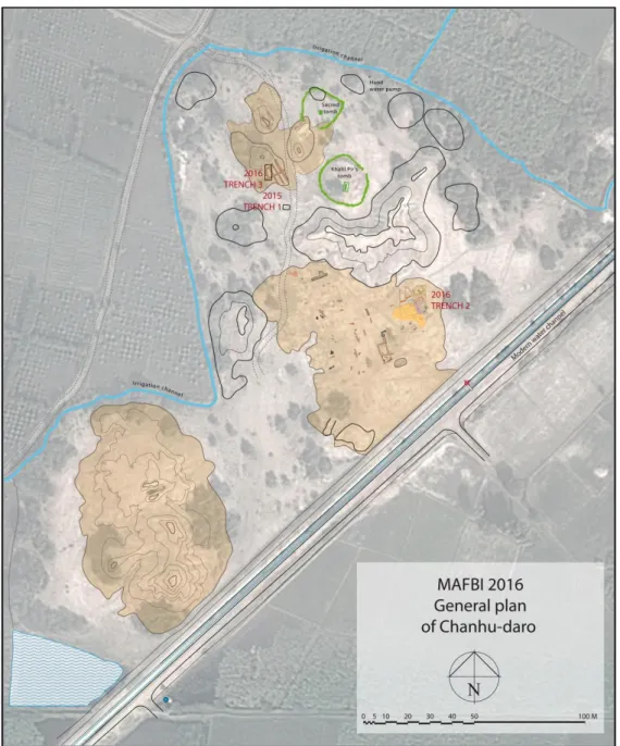
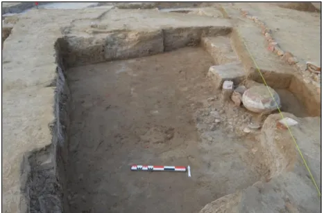
The objective of the short field-work carried out at Chanhu-daro from March 11th to March 17th 2015 was to evaluate the state of preservation of levels dated from the first Indus period. We decided to select a small area in an open-plan space comprised between Mound II and III to open a test-sounding (Trench 1) of 3 meters long by 2 meters large and oriented east-west (Fig. 7). After a surface cleaning, excavations started at 27.9 m above sea-level7 (Mackay’s datum = 28.15 meters above see-level; 1943: vi). The maximum depth that we have reached was about 2.85 meters below the ground surface. This depth can be explained by the limited time available for the work, but also by muddy soil in the deepest layers of Trench 1 due to the water table level much higher than in 1936. Indeed, it is important to remind that Mackay stopped excavating in the deep cutting due to the level of sub-soil water measured at 7.8 meters below his datum in March 1936 (8.8 meters in January 1936); he did not reach the virgin soil.
Figure 7: General plan of Chanhu-daro with location of Trenches 1, 2 and 3 (Map: J. Humbert © MAFBI).
7
8
Trench 1 - Stratigraphy
Overall, the remains excavated in Trench 1 can be linked with four architectural levels (Fig. 8):
Level A (0/-0.60 m below datum) - the latest architectural level - is a thick layer of debris. Level B (-0.30/-0.60 m below datum) is materialized by a mudbrick wall for which a single
course of bricks is visible in the northern section of the trench. The filling layer associated with Wall A is mainly composed of debris and fragments of mud-bricks probably collapsed from the wall. The discovery of a mud-brick wall is in line with the mud-brick architectures observed by Majumdar in the trial-trenches dug in Mound III, but not described (Majumdar 1934: 36)8.
Level C (-0.70/-1.20 m below datum) – which corresponds to an earlier occupation phase –
provided the remains of a mud-brick wall preserved on three courses and orientated south-west/north-east (Fig. 9). The orientation of the wall is similar to those of posterior architectures in fired bricks excavated by Mackay in Mound II. The size of the mud-bricks (29 x 13 x 7 cm) is rather close to the size of the bricks that composed the mudbrick structures found below the Harappa II level (28.5 x 14 x 7 cm). The wall which shows a return in the north-west corner of the trench delimits three rooms (Locii A, B and C) in which numerous fragments of terracotta bangles, balls and cakes were found.
Level D1 (-1.20/-2.20-2.30 m below datum) corresponds to a debris layer composed of
heterogeneous clay sediments mixed with burnt sediments and ashes in the deepest part. This layer provided very large amounts of terracotta cakes, fragments of bangles, balls and ceramics. The remains of a mud-brick structure (a wall?) associated with these layers is visible in the western section.
Level D2 (-2.20-2.30/-2.85 m below datum) is characterized by a debris layer composed of clay
sediments mixed with burnt sediments, ashes, kiln firing wasters, small fragments of vitrified walls (which could belong to a firing structure) and charcoal. This layer provided a large deposit of pottery sherds. Due to logistic constraint, it was not possible to complete the excavation of these layers, but, despite the limited excavated surface, we can assume that a craft production area for manufacturing terracotta objects and/or pottery could be located in this part of the site what corroborates the surface observation carried out by Sher and Vidale (Sher and Vidale 1984: 598; Vidale 1989).
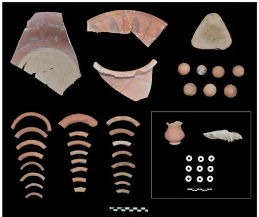
Trench 1 – Pottery and small finds (Fig. 10)
About 1000 ceramic sherds were collected in Trench 1 (Table 1), among which about 600 sherds were individualised for pottery studies. The macroscopic observation of the ceramic paste showed that the studied corpus is highly dominated by vessels with fine or medium-fine paste characterized by well-sorted mineral fabric. Overall, the colour of the ceramic paste ranges from brownish light red to pinkish buff and the great majority of the vessels have been fashioned by the wheel-throwing technique. 18 form-classes of vessels have been documented (Table 2), what represents an important morphological variability if we consider the limited size of the sounding. The most common forms of the assemblage are dishes-on stand with high pedestal, large bowls/basins with bilateral projecting rim, short-necked globular jars and pots with rounded rim projecting on the exterior. In general, the surface treatments of the vessels display red or pinkish-buff to cream slips. Other surface-finishing techniques are used such as comb-sand slip, sandy coating and cord-impressions. In addition, sherds of dish-on stand have incised or impressed decoration on the interior surface.
8“[…] the structures that one stood here must have been principally of sun-dried bricks, the use of burnt bricks
9
Figure 8: Trench 1 - West-East section.
Figure 9: Trench 1 – Plan of Level C.
Decorations painted in black, dark brown or red have been observed on dishes-on stand, jars and pots. Horizontal bands, wavy lines and interlacing circles are the most commonly attested, but the decorative motifs also include peacocks (head, body or tail) and friezes of vertical hatched leaves separated by wavy bands (Fig. 10) that have a clear resemblance to motifs seen on vessels found at Nausharo period II, Amri period IIIA, Miri Qalat period IV and Mohenjo-daro (deep soundings). As mentioned by G. Quivron (2000: 178), the pottery related to the first Indus period is “the most
homogenous stage in his evolution. This is also the reason why [this] pottery [which shows intricate abstract and naturalistic black motifs depicted on a red glossy slip] is more easily recognizable in the corpus of ceramics of the various Harappan sites.” On the basis of this comparative study, we can
argue that the painted ceramic vessels collected in Trench 1 correspond to the ceramic style from the first period of the Indus Civilization (2600/2500-2300 BCE). It is interesting to note that a few sherds have been painted directly on the external surface without the prior use of red slip. It is the case for an incomplete short-necked globular jar found in Level D that displays a peacock motif. This observation has also been made for some painted vessels dated to the first Indus period found at Miri Qalat (Didier et al., forthcoming).
10
Layer Level Pottery
sherds TC cakes TC bangles TC balls TC figurines 1 1 13 1 9 - 1 2 1 36 4 20 1 - 3 2 28 10 35 2 - 4 3 21 8 23 1 - 5 1 - - - - - 6 1 21 - - - - 7 3 9 2 2 - - 8 3 91 - 20 - 1 9 3 29 63 18 - - 10 3 - - - - - 11 3 28 30 20 5 - 12 3 39 + 3 kg 7 - 1 13 3 42 8 3 - - 14 4a 86 + 2 kg 31 6 - 15-16 4a 92 + 6 kg 70 10 - 17-18 4a 102 + 3 kg 27 2 - 19-20 4b 285 + 15 kg 19 - -
Table 1 : List of pottery and terracotta objects recorded in Trench 1.
# Form-class Nr. Paste type Red slip Painting Incised
decoration
1 Dish, projecting rim 3 Fine 1 2 -
2 Dish-on stand, high pedestal 22 Fine, medium-fine 14 8 2
3 Shallow bowl 1 Fine - - -
4 Large bowl, bilateral projecting rim 13 Fine, medium-fine 7 2 -
5 Carinated bowl, bilateral projecting rim 4 Fine, medium-fine - - -
6 High cylindrical beaker, everted rim 1 Medium/fine - - -
7 Miniature globular pot, short neck 2 Fine - 2 -
8 Miniature wide-mouthed globular pot 1 Medium/fine - - -
9 Short-necked globular pot, everted/projecting rim 8 Fine, medium/fine 1 2 -
10 Short necked biconical pot, projecting rim 1 Medium/fine - - -
11 Ledged globular pot 1 Fine 1 - -
12 Restricted jar 1 Medium/fine - - -
13 Restricted jar, projecting rim 2 Fine - - -
14 Short-necked globular jar, everted/projecting rim 12 Fine, medium/fine 1 4 -
15 Jar with medium neck, outward turning 1 Fine, medium/fine 1 1 -
16 Jar with medium neck, inward turning 8 Fine, medium/fine 3 2 -
17 Medium-necked carinated globular jar 1 Fine - - -
18 Base of bowl/jar/pot 22 Fine, medium/fine 2 1 -
Table 2 : Form-classes of ceramic vessels recorded in Trench 1.
A variety of small find objects mainly made in terracotta were recovered from Trench 1 (Table
1; Fig. 10). The range of terracotta objects predominantly comprised of nodules or “cakes” made of
hand-modelled clay exposed to high temperature. The largest quantities were collected in the layers of Levels C and D, in which they were associated with numerous fragments of terracotta bangles and balls. The majority of terracotta cakes - mostly found fragmented - is triangular-shaped, but we also collected ovoid-shaped cakes. In Level D, their association with other pyro-technological indicators such as kiln wastes and fragments of vitrified (kiln?) walls may indicate the presence of an area of craft activity nearby. Despite the limited size of the sounding, we collected more than 300 fragments of terracotta bangles with a diameter ranging from 0.5-0.6 cm to 1.7 cm. Most of them were painted in red, some with motifs of hatchings or drops. Terracotta balls, most numerous in Levels C and D, have a diameter ranging from 2.5 to 3.7 cm. Some of them have motifs of dots or concentric circles painted in red. The assemblage also includes one rattle (DIA=5.5 cm), rare fragments of carts with hatchings motifs painted in red and figurines: one overfired leg of human figurine bearing jewelry, one bird head painted in red and one fragment of unidentified animal figurine. A limited range of stone objects was recovered from Trench 1: several disc-shaped beads made in fired steatite (DIA= 1.25 cm) collected in Levels A and B, two grinding stones (one with traces of red pigments), one flint
11
scraper and rare fragments of chert blades. 31 bone fragments (most of them burnt) and 5 shells and/or fragments of shell were also found.
Figure 10: Trench 1 – Selection of pottery and small finds.
The 2016 field-season
The second field-season at Chanhu-daro took place between January 11th and February 17th 2016. With the cooperation of Culture, Tourism and Antiquities Department, Government of Sindh, and other scientific partners, the Pakistani-French team has welcomed fresh graduated students in archaeology (BA and Masters), young field-officers and assistant curators from various institutions (Culture, Tourism and Antiquities Department, Exploration and Excavation Branch, Department of Archaeology, University of Sindh-Jamshoro, Endowment Fund Trust for Preservation of the Heritage of Sindh, Taxila Institute of Asian Civilizations, Quaid-e Azam University, Islamabad) for a training programme in field-archaeology. During almost six weeks, the team was hosted at the Kerio House in Jemal Kerio village, about 800 meters north of the site.
Objectives
Based on the promising results obtained in 2015, our objectives for the 2016 field-season were to achieve an updated map of the site and select a relevant area in order to start excavating architectures dated from the first period of the Indus Civilization on a large-scale. As mentioned above, this large-scale study could be implemented only in the location of Mound II where architectural remains of ‘Harappa II’ level dated to the second Indus period have entirely disappeared due to erosion and the recent re-use of fired bricks. The goal of the project was also to better understand the nature and the function of the massive mud-brick structures identified by Mackay below the ‘Harappa II’ architectures (Mackay 1943: 37) and in the Cutting (Ibid.: 15), but never excavated. These substantial mud-brick structures which tops range from 2.25 m to 3.25 m
12
above the 1936 datum9 were described as “ […]upper portions of solid platforms of unburnt brick […]” (Ibid.: 37). In addition, Mackay said that “Platforms such as these are well known at Mohenjo-daro,
where they were expressly constructed to raise buildings beyond the reach of floods” (Ibid.). Overall, a
number of concerns raised if we consider the location of these structures on Mackay’s plan (Ibid.: Plates IV and VI) – they are only identified in the southern and eastern parts of Mound II and in the Cutting - their form - described as “compacted damp structures” not clearly visible10, and their possible function. One of the 2016 priorities was to determine their limits and the way that they were built, but also to see if:
a- These structures have indeed been constructed to raise buildings from the second Indus period beyond the reach of floods.
b- They could be groups of mud-brick walls from levels dated to the first Indus period associated with rooms which were filled with bricks collapsed from walls.
c- They could be groups of mud-brick buildings intentionally transformed into platforms to make the ground suitable for building new structures during the second Indus period.
d- They were other kind of massive structures to be determined.
Since the information available in the published report is not sufficient for reconstructing the formation processes of the site and the spatial distribution of activity areas within the different architectural levels previously established (Vidale 1984: 177-178), excavating a large area in the location of Mound II along with a careful examination of stratigraphic data could also bring new evidences to see if specific developments in artefact styles, craft technologies, types and organization of craft activities occur during the first period of the Indus civilization. Several scholars often argued that Chanhu-daro witnesses a very specialized character much larger than at Mohenjo-daro, particularly in the lapidary working highly organized and produced at a large scale (Ibid.: 179-180), but again, the ‘Mature Harappan’ phase at Chanhu-daro was so-far studied as a single synchronic complex.
Trench 2 – Stratigraphy and architectural remains
Trench 2 was opened in the north-eastern part of the area where Mound II was located in 1935-1936, few meters away from the southern slope of the main debris dump (Fig. 7). It is situated at the location of Squares C6 and C7 in Mackay’s plan (Mackay 1943: Plate IV) that displays the presence of mudbrick structures, and near an area where G.M. Sher and M. Vidale collected surface evidences of craft activities including kiln firing wasters and faience smelting assemblages (Vidale 1989: Fig. 18.3). Trench 2 is oriented North-South and measures 12 meters large by 20 meters long. Excavations started at a level between 27.6 and 28.5 meters above see-level with a careful surface cleaning to locate the possible foundations of architectural structures in fired bricks already excavated in 1935-1936 and identify remains of an earlier occupation. The maximum depth of excavations was at 1.60 meters below the surface level. In total, Trench 2 provided the remains of 7 architectural levels (Levels A to G; A is the latest one; G is the earliest one) including several groups of rooms delimited by narrow lanes and equipped with domestic installations, as well as a portion of a massive structure (Fig. 11). The great majority of the architectural remains is built in mud-brick except the structures ascribed to Level A that correspond to foundations of walls excavated by Mackay (which belong to ‘Harappa II’ level and dated to the second period of the Indus Civilization) and other structures discussed below.
9
About 0.75 m to 1.80 m above the current ground surface.
10 Mackay also noted « we were unable to extract single bricks for measurement until the platform had dried out sufficiently to allow the courses to become clearly visible » (Ibid.: 19).
13
Figure 11: Trench 2 – Plan of architectures excavated in 2016 (Map: J. Humbert © MAFBI).
Level A - The remains of Level A consist of few portions of walls in fired bricks (usually a single
course of bricks) - which have to be associated with the lowest level (or foundations) of the ‘Harappa II’ occupation excavated by Mackay -, a portion of a drain and a large storage jar found in the north-eastern part of the trench.
Level B – It corresponds to debris areas filled with large amounts of pottery sherds and burnt
sediments. The painted ceramics display the typical style used during the first period of the Indus Civilization. These debris layers which cover predominantly the eastern part of the Trench could come from anterior domestic areas.
Level C1 and C2- The remains of the earlier Level C clearly show that the architectures of the
‘Harappa II’ level have not been built on a solid mudbrick platform used to raise buildings beyond the reach of floods as stated in previous interpretations, but stood on anterior buildings in mudbricks. A group of two small rooms oriented north-west/south-east and characterized by relatively thick walls have been exposed in the north-western corner of the trench. They are delimited in south by a lane
14
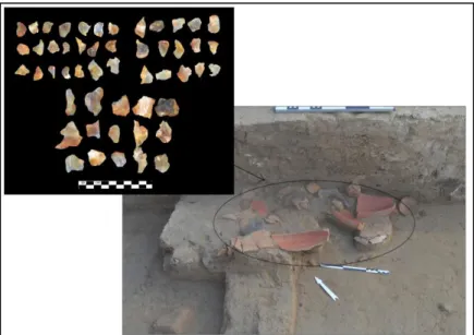
filled with a thick layer of ceramic sherds dated to the first Indus period. To the east, we excavated another building that displays a cell or compartment set up in the thicker north wall and a room (called the “Eastern Room”) which provided a painted storage jar and a fireplace (Fig. 12). The building is delimited to the west by a lane north-south orientated. Several architectural modifications in this area occurred later (Level C2). Three buttresses in fired bricks have been edified in the north-south lane along the thick wall of the building (Figs. 11, 13). One of them is equipped with an outer casing in mudbrick. These structures in fired bricks are used to reinforce the western wall preserved on 10-12 courses of mudbricks. The north-south lane was also crossed by an open drainage channel or sewer (not built in bricks) that collected the water from South to North and ended by an outlet composed of two fired bricks at the point of intersection with the east-west lane. The filling of the sewer was full of ceramic sherds. In the north-south lane, a deposit of agate/carnelian flakes was found along the western wall of the eastern building. It was associated with a broken vessel that might have been its container (Fig. 14). Many remains of craft activities including flakes, worked stones (steatite and carnelian), chert blades and drills were also collected in the filling layers of the north-south lane.
Figure 12: Trench 2 – Level C: The ‘Eastern Building’.
15
Figure 14: Trench 2 – Level C: Deposit of agate/carnelian chips found in a broken vessel.
Level D – This level is mainly represented by the construction (as a whole) of a massive
structure in mud-brick which was identified in the western part of the trench just beneath the surface level (Fig. 11). We excavated a portion of it over 10 meters long (on western side) and a maximum depth of 1.20 meters. From an architectural point of view, this massive structure preserved on 17 courses of bricks differs from the buildings excavated around. It includes quadrangular cells of various sizes11 planned during its construction (Figs. 11, 15-17). Two courses of bricks that form the foundation of the building also served as bottom of the cells. The excavated cells that were filled with clay sediment were totally empty of pottery or artefacts. The other particularity of the building is its construction method. If it was built in mudbricks, it also shows an exterior facing in fired bricks (Figs. 15-16, 18). This facing is composed of 6 to 7 courses of bricks and does not reach the bottom of the structure. A section done in the north-eastern corner has clearly shown that it has not been added in a second architectural phase, but integrated into the masonry at the time of the construction of the building. In its north-eastern part, the building also displays two large steps bordered by a facing of fired bricks that did not run the full length of the façade (Figs. 15-16, 17, 19). The lower step has been seriously damaged by the overflowing of the sewer and the construction of the “Eastern” building during Level C.
Level E– Although they have distinguished in a separate level, the architectures ascribed to
Level E were contemporary to the massive building from Level D. These remains have been mainly exposed in the north-eastern and eastern parts of the trench just below the surface. In north-east, a group of rooms which measure respectively 3.60 m and 5.60 m long borders two lanes forming a crossroad (Fig. 11). The construction of the walls in mudbrick, less thick than in Level C, shows a traditional architectonic system that consists in two layers of alternated bricks. One layer is composed of a course of heading bricks bordered by stretching bricks. The top layer is composed of two courses of heading bricks. It is interesting to note that a mudbrick wall overlooking the east-west lane is equipped with a course of fired bricks on its exterior part, but only along a portion of about 2 meters long (Fig. 20). The wall section showed that it was not a foundation or a course separating two distinct phases of construction. This course of fired bricks has been directly integrated into the masonry. It could have been associated with a broken storage jar placed against the wall in the lane.
11
When we measured the cells, we noticed that they are proportionally sized (0,5, x1, x2, x3, x4, x8). The length of the smallest cell is equivalent of the width of its nearest multiple. The sizes of the cells could be related to the way they were used as it is the case at Nindowari according to the hypothetical reconstruction of the ‘Granary’ from Sector B made by G. Quivron (Jarrige et al. 2011: 55).
16
In the northern room and just on the other side of the wall, we found another broken jar, a fire place and three grinding stones. Other domestic installations were identified in the ‘Eastern building’ for which a continuous occupation can be observed from Level G. Three superimposed storage jars have been installed and each of them was filled with a single layer of terracotta cakes carefully placed in the bottom (Fig. 21). These jars have been partly damaged by the installation of the storage jar used in Level C. We excavated nearby two superimposed fire places. The layers of this room provided large amounts of terracotta bangles, balls, beads, animal figurines - some of them burnt - and a diversified assemblage of ceramics including a substantial collection of miniature pots. This space could have also been used for pyrotechnological activities as may indicate the discovery of fired materials of yellow/green colour - not identified yet – and large quantities of overfired terracotta cakes.
17
Figure 16: Trench 2 – Axonometric reconstruction of the ‘Massive Building’.
Figure 17: Trench 2 – Schematic west-east section.
18
Figure 19: Trench 2 – Steps of the ‘Massive Building’.
Figure 20: Trench 2 – Level E: Mudbrick wall showing a 2 meter course of fired bricks integrated into the masonry.
19
Level F– This level corresponds to two groups of structures laid at the same altitude. In the
‘Eastern building, the architectural unit is divided into two small distinct spaces by a separating north-south wall of 2 meters long and preserved on a single course of bricks (Fig. 11). The corner of a third room is visible to the south. Few meters to the north-west, an imposing layer of bricks was reached in a sounding dug in the east-west lane. This massive structure, whose only upper part was excavated, consists in mudbricks uniformly arranged and a rectangular space or cell similar to those identified in the massive building ascribed to Level D. It is clearly separated from the latter by a debris layer of 10-15 cm thick (Fig. 22). This led us to consider the existence of an earlier massive building equipped with cells below the remains of the Level D building.
Level G–Very few architectural remains from this level have been excavated in Trench 2. They consist in portions of walls composed of a single course of mudbricks excavated in the southeastern part of the ‘Eastern Building’ at a level of 1.50-1.60 meters below the surface (Figs. 11, 23). These walls form the corner of a domestic structure. North of it, we found a layer of ashes and fragments of burnt bricks most likely associated with a firing structure.
In view of the stratigraphy and architectural studies, we can argue that the architectural remains excavated in Trench 2 (Fig. 24) show a division of the occupied space into three distinct areas during Levels G to C ascribed to the first period of the Indus Civilization (2600/2500-2300 BCE) from pottery studies (see below):
1. To the east, a building (the ‘Eastern Building’) surrounded by lanes was occupied continuously from Level G to Level C and perhaps before. The inner space that provided small rooms with domestic installations (storage jars and fire places) shows changes in configuration settings during Level C characterized by the removal of dividing walls. The size of the building – smaller than a traditional Harappan dwelling as those found in Nausharo, Miri Qalat or Kot-Diji, the addition of a thicker wall reinforced by buttresses in fired bricks during Level C, and the discovery of large amounts of terracotta cakes associated with fired materials and fireplaces raised questions about the function of this building.
2. To the west, the space is occupied by a massive building preserved on 1.00-1.20 meter high and equipped with cells of various sizes. The presence of an earlier massive structure below may indicate an architectural and functional continuity from Level G to Level B(?) The nature of these massive buildings, their construction methods and stratigraphic location make clear that they cannot be interpreted as platforms used to raise the buildings of the ‘Harappa II’ level beyond the reach of floods. It was indeed clearly established that the building from Level D - surrounded to the North and East by contemporary dwellings and other buildings to be determined - does not correspond either to the second Indus period or to the final architectural level ascribed to the first Indus period, but it belongs to an earlier level dated to the first Indus period. Nevertheless, its function remained enigmatic. Was it a public building such as a granary or another kind of building to be determined? Further excavations could also help to define if the excavated portion belonged to a vast complex that extended on a large area to South as it would be suggested by the plan of “massive mudbricks structures” reported in Mackay’s publication (1943: Pl. IV) or if it was part of a group of large buildings to be determined. 3. To the north, the architectural units consist in dwellings and building with thicker walls and
20
Figure 22: Trench 2 – Top of the ‘Massive Building’ from Level F.
Figure 23: Trench 2 – Level G: A room of the ‘Eastern Building’.
Another significant conclusion from Trench 2 excavations concerns the building methods used during Levels E to C. Indeed, as mentioned above, architectures was built in mudbrick contrary to those of the ‘Harappa I-II’ occupations in fired bricks which can be dated a posteriori to the second period of the Indus Civilization. However, the use of fired bricks was occasionally used in specific cases: a- to build buttresses in order to reinforce a mudbrick wall; b- to make the exterior facings of
21
walls and steps of the massive building; and c- to make installations not determined yet. Overall, the excavated sites that provided levels dated to the first Indus period yielded either architectures exclusively in mudbrick except the water structures in fired bricks (Nausharo, for example, where mudbrick is also used for architectures dated from the second and third periods of the Indus Civilization), architectures in mudbrick built on stone foundations such in Kot-Diji; architectures in mudbrick including some stone installations (Miri Qalat for example where stone is used to build portions of walls, bathrooms, and to arrange floors), or architectures largely made of stones such in Dholavira.
Figure 24: Trench 2, general view from north.
Trench 3 – Stratigraphy and architectural remains
From the results obtained in 2015, we decided to proceed to a careful surface cleaning of the south/south-east part of Mound III and to open a trench of 7 by 3 meters (Trench 3) oriented North-South in its southern slope – the only part not covered by vegetation or affected by modern occupation12, few meters north of Trench 1 (Fig. 7). The objective was to bring further contextual data related to an occupation from the first Indus period. Indeed, the re-examination of data published in 1934 showed that the painted ceramics collected in the trial-trench dug by Majumdar in Mound III and characterized by an extraordinary skill in the quality of their painting technique had to be dated to the first period of the Indus Civilization (Quivron 2000: 186, Fig. 9). The excavation of Trench 3 started at a level of 29.36 meters above-see level in its northern part, 28.36 meters in its southern part. The maximum depth reached in south is at 27.71 meters above see-level, 20 cm lower than the ground level measured in the 2015 test-sounding. In general, excavations provided the remains of six architectural levels (Levels A to F) that display an orientation and a stratigraphic location comparable to those of the levels excavated in Trench 2 (Fig. 25). These levels were associated with mudbrick structures.
Level A – Architectures ascribed to this level were identified only in the northern section and in
a limited area located outside the northern limits of the trench (Fig. 25). They consist in the south corner of a building whose upper remains are covered by vegetation at the top of the mound. One large storage jar has been excavated west of it. Unfortunately, its painted decoration was not preserved. It could have been used for collecting water as may indicate the dipping layers observed in the section.
12 This “modern” occupation includes the grave of Khalil Pir, already reported in Mackay’s report (1943) and the installation of a recent sacred place, both accessible by a path following the alignment of Majumdar’s trench.
22
Figure 25: Trench 3 – Plan and architectural levels.
Level B – It corresponds to a group of rooms delimited by mudbrick walls (45 cm thick) preserved on three courses in the northern part (Figs. 25-26). To the south, the walls are preserved on one course only due to erosion. The filling layers of the central room (or Locus A) which measures 2.30 meters long by 1.60 meter large provided large amounts of pottery sherds, among which numerous painted sherds display beautiful decorative motifs characteristic of the first Indus period. A large black slipped jar has also been installed in the northern room. It was damaged later by the installation of the jar from Level A. To the east, the surface cleaning brought to light groups of rooms equipped with domestic installations (bottoms of storage jars) which form a very coherent plan and that have to be connected with this level.
Level C - This earlier level shows a configuration of the space quite similar to those of Level B,
except the northern part occupied by a narrow lane filled with terracotta cakes (Fig. 25). The walls of the central room preserved on three courses are thicker than in the subsequent level (60 cm wide; four rows of bricks) (Fig. 26). In its northern part, the central room was equipped with an installation composed of an alignment of four mudbricks.
Level D – The architectural remains of Level D were excavated only in the southern part of the
trench. Their study shows an earlier use of the central Locus A and adjacent rooms, but the walls are less thick than in Level C (45 cm wide; two rows of bricks).
Level E – This level corresponds to a thick debris layer (30 cm) full of pottery sherds below
Level D (Figs. 26-27).
Level F– Structures from Level F have been identified only in a limited area south of Trench 3 (Figs. 25, 27). Overall, this area shows a different use of the space; the central room does not seem to exist yet. In the south-western corner of the trench, we excavated a portion of a wall oriented north-south which displays traces of burning. A painted jar was found north of it (Fig. 27). The jar was installed along a small mudbrick wall (a bench?) formed by two lines of mudbricks. It is interesting to note that the rim of the jar was flanked with three fired bricks while another fired brick was placed below its bottom.
23
Figure 26: Trench 3 – Levels B-D and storage jars from Levels A-B.
Figure 27: Trench 3 – West-east section.
Overall, we assume that there was no major architectural change in this part of the site from Level E to Level A. The phases of destruction, levelling/refilling and construction of new walls seem to occur in a relatively short period of time. The general plan of the area which shows groups of quadrangular rooms - orthogonally disposed –indicate a function rather residential. However, a distinct use of the space could be identified in earlier Level A. The structures excavated in Level A may have a link with the remains of craft activities identified in Trench 1.
Pottery and small finds (Figs. 28-29)
Very large amounts of potsherds were recorded in Trench 2 and Trench 3, but 10% of the corpus (3 100 potsherds considered as “diagnostic material” in terms of fabric observed by naked eye, form, decoration) was subjected to description (Tables 3 and 4). All ceramics recorded in Levels B-G from Trench 2 and Levels A-F from Trench 3 can be dated from the first period of the Indus Civilization (2600/2500-2300 BCE) on the basis of comparisons with the ceramic assemblages from Nausharo II, Amri IIIA, Kot-Diji (Harappan occupation), Miri Qalat IV and Harappa 3A. Overall, if the studied corpus is dominated by vessels showing a remarkable quality in fabric (well-sorted mineral or sand fabric), manufacturing (the wheel-throwing technique was used for the great majority of the
24
ceramics) and painted decoration, we noticed that Trench 3 yielded a higher proportion of decorated potsherds which are characteristic of a very elaborate and realistic painted style such as those identified in Period II levels at Nausharo (Fig. 28). Trenches 2 and 3 also provided several large jars, complete or fragmented including: 1) In Trench 2: an imposing short-necked globular jar associated with the remains of a drain and excavated in Level A; a short-necked globular jar bearing a painted decoration not preserved and three superimposed globular jars in the ‘Eastern building’; two globular jars found in the east-west lane and in the room north of it. 2) In Trench 3: a large painted globular jar (its decoration is not preserved) and a black slipped jar with pointed base in the upper levels; a short-necked globular jar with a painted decoration was also excavated in Level F. Its motifs (peacock and leaves) are less elaborate than those identified on other vessels from Trenches 2 and 3.
The classification of forms was based on metric and visual criteria (ratio of the external height to the maximum body, rim-diameter, body, rim and base shapes, degree of outcurve of mouth and neck for jars and pots …). In Total, 38 form-classes have been documented; the number of specimens for each trench is given in Table 4. The most common forms of the assemblage are:
- Dishes-on stand with high pedestal. Most of them are decorated with red slip, black paint and incisions or impressions on the inner surface of the dish.
- Medium/large hemispherical bowls with external, internal or bilateral projecting rim. The great majority of the specimens covered with both red slip and showing cord-impressions on the outer surface are bowls with bilateral projecting rim. 25% of the vessels have also been decorated with a dark brown or black slip on the exterior. The proportion of the vessels decorated with black slip increases for the large/medium bowls with a carinated body.
- Short-necked globular pots and jars of various sizes. The surface treatments of the vessels mainly include red or cream slip, but comb-sand slips, sandy coatings and cord-impressions are also observed. The painted decorations depict geometric and naturalistic motifs: hatched patterns, hatchings, zigzags, interlacing circles, vegetal suns, diversified hatched leaves and pipal trees, flowers, sun motifs, fish-scale motifs, peacocks and other animals, not identified.
86 miniature pots were recorded in Trench 2, among which, a high proportion was found in the ‘Eastern Building’ (Levels C, E-F). They are characterized by a rather significant morphological variability (high cylindrical cups, short-necked globular pots with flat or disc-base, footed globular pots or biconical pots). Some of them are extremely small in size (less than 3 cm high). A third of the miniature pots is decorated with horizontal bands painted only in red colour.
A much diversified range of terracotta objects was recorded in Trenches 2 and 3 (Fig. 29). It is worth stating that the small find assemblage predominantly comprise painted terracotta bangles of various diameters, balls and rattles, wheels and fragments of carts which were often decorated with oblique hatchings painted in red, long barrel or cylindrical shaped beads painted in red – less are the tubular and biconical beads in terracotta -, as well as animal figurines. Although bull figurines are the most numerous (particularly those collected in the ‘Eastern Building’ from Trench 2), we observed that the proportion of bird figurines remained quite significant. By contrast, rare fragments of human figurines were recorded. Even if the excavated surfaces significantly differ from one site to another one, it is interesting to note that the ‘Harappan levels’ excavated at Kot-Diji and ascribed a posteriori to the first Indus period, provided only rare animal figurines and no human figurines (Khan 1965). The excavated trenches have produced a variety of toys, playthings, containers and other objects in terracotta whose function is not yet well-determined: cones, disks, tokens, rings, triangular-shaped gamesmen, whistles, bobbin-like objects, boxes, fragments of painted miniature “tables”, cylinders, weights, a pipe-shaped object … However, no seal was found.
25 Studied pottery sherds TC Animal figurine TC bangle (Fragment) TC ball & rattle TC bead TC Cart & Wheel TC Cone, Whistle & Gamesman TC Disc & Ring TC Human figurine TRENCH 2 2 280 33 444 175 65 60 9 6 3 TRENCH 3 830 6 217 30 18 13 2 3 2 TC Miniature Table Limestone Ball Limestone Vessel Steatite bead Other Stone bead Chert
Blade Stone Tool
Shell Bangle
TRENCH 2 4 4 1 154 9 47 7 15 -
TRENCH 3 - - - 38 3 7 2 3 -
Table 3 : List of pottery and terracotta objects recorded in Trench 2 and Trench 3
# Form-class T.2
Nr. T.3 Nr.
Red slip Brown /
Black slip
Painting Incised or impressed decoration
1 Small dish, external projecting rim 4 1 - - 1 -
2 Medium/Large dish, external projecting rim 1 1 - 1 1 -
3 Dish-on stand, high pedestal 249 94 311 7 131 84
4 Medium/Large conical bowl, internal projecting rim
6 2 - 1 - -
5 Medium/Large hemispherical bowl 1 1 4 - 1 -
6 Large hemispherical bowl, external projecting rim - 1 - - - 1
7 Small hemispherical bowl, internal projecting rim 4 1 2 2 1 -
8 Medium hemispherical bowl, internal projecting rim
36 2 6 12 8 -
9 Large hemispherical bowl, internal projecting rim 38 7 11 - 2 -
10 Medium hemispherical bowl, bilateral projecting rim
3 - - - 2 -
11 Large hemispherical bowl, bilateral projecting rim 70 60 65 - 20 55
12 Medium carinated bowl, external projecting rim 5 - 4 - 4 -
13 Large carinated bowl, external projecting rim - 2 - - - -
14 Small carinated bowl, internal projecting rim 1 2 - 3 - -
15 Medium carinated bowl, internal projecting rim 1 - - - - -
16 Medium carinated bowl, bilateral projecting rim 15 2 7 3 1 -
17 Large carinated bowl, bilateral projecting rim 12 6 15 - 6 -
18 Large Basin 2 1 - - - 3
19 Miniature cylindrical cup 14 1 2 - 1 -
20 Miniature short-necked globular pot 54 5 4 2 19 -
21 Miniature medium-necked globular pot 3 - - 2 - -
22 Miniature footed globular pot 11 2 5 - 6 -
23 Miniature footed carinated pot 1 1 - - 1 -
24 Miniature short-necked biconical pot 3 1 1 - 3 -
25 High cylindrical pot/beaker, external projecting rim 2 - - - 1 -
26 Short-necked globular pot, external projecting rim 99 41 51 3 23 -
27 Small short-necked globular jar, external projecting rim
135 17 59 - 6 -
28 Medium short-necked globular jar, external projecting rim
89 17 11 - - 1
29 Large short-necked globular jar, external projecting rim
111 78 122 22 108 3
30 Medium-necked globular pot, external projecting rim
17 5 11 2 11 -
31 Medium medium-necked globular jar, external projecting rim
24 27 - - - -
32 Large medium-necked globular jar, external projecting rim
- 26 21 - 22 -
33 Short necked biconical pot, projecting rim 34 Short/Medium-necked carinated pot/jar, external
projecting rim
11 3 14 - 11 -
35 Ledged globular pot 153 48 77 64
36 Restricted jar 1 - - - - 1
37 Cylindrical jar, perforated 38 22 3 1
38 Lid 17 10 1 - 1 -
26
Figure 28: A selection of painted ceramics from Trenches 2 and 3 dated to the first period of the Indus
Civilization (2600/2500-2300 BCE).
27
The ‘finished’ stone ornaments unearthed in Trench 2 and Trench 3 form an interesting collection (Fig. 29). The greater part includes disc-shaped beads in fired steatite (about 200 specimens), rare facetted biconical bead in fired steatite, one beautiful tubular bead in lapis lazuli (L= 2.5 cm) and a dozen of tubular carnelian beads and etched carnelian beads characterized by their remarkable quality. The fillings of rooms and lanes from Trench 2 yielded evidence of craft activities mainly associated with bead making or more generally lapidary working: large amounts of worked stones (blocks of unfired dark grey and greyish-beige steatite often exhibiting saw marks and steatite chips; for chalcedony stones – agate, carnelian and jasper?, numerous pebbles, worked blocks, chips and flakes), preforms of carnelian or steatite beads, many specimens of unpolished, non-perforated or failed carnelian beads, but also drill fragments in Ernestite and possibly jasper or flint. In the same levels, numerous chert blades and pointed blades used for pecking the beads were recorded. These discoveries show that a manufacturing area could have been located nearby. It is interesting to note that substantial evidence of bead making activities, highly organized and produced at a large scale along with remains of sophisticated pyrotechnological structures were recorded in “open spaces” in the subsequent ‘Harappa II level ‘Harappa II’ level (second period of the Indus Civilization) in the eastern part of Mound II (Mackay 1943: 199-241; Vidale 1989: 172).
However, the proportion of shell objects, worked shells and shell bangles identified in Trench 2 is far less numerous. Likewise, animal bones were found in limited quantity. Trench 2 provided one incomplete mirror in copper-based metal and few other objects in polished limestone: one bowl, three balls which could have been used as weights, and one palette. Beads in terracotta, steatite and carnelian, animal figurines and large amounts of painted ceramics characterized a very good technical and decorative quality in the truly fine tradition from the first Indus period were recorded in Trench 3. However, it is interesting to note that the excavated rooms did not provide remains of craft activities similar to those discovered in Trench 2. This led us to assume that this part of the settlement might have rather a residential function during this period.
Addendum – Short account on the 2017 field-season
Given the recent completion of third field-season at Chanhu-daro, it was interesting to provide a short account on the preliminary results of this work which took place during six weeks from January 15th to March 5th 2017. The excavation report to be delivered soon to the Department of Archaeology and Museums of Pakistan Culture, Tourism and Antiquities Department, Government of Sindh during Summer 2017 will be the subject of a separate publication.
The objectives of this last field-season were focused on the study of the layout of the settlement from the first Indus period including the reconstruction of the complete plan of the ‘Massive Building’ along with an emphasis on the methods of construction used during this period. The work also aims at identifying the context from where the remains of craft activities came and better documenting the craft productions from this phase of the first Indus Period.
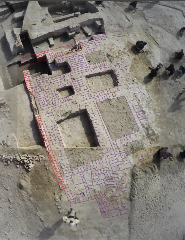
First results on the layout of excavated architectures
In total, a surface of about 900 square meters has been excavated around and south of the ‘Massive Building’ identified during the previous field-season. It provided the remains of a vast complex with mudbrick architectures that comprised rooms of various shapes and sizes, cells, and was encompassed to north and south by lanes (Figs. 30-31). Its internal part was accessible by secondary lanes that indicate a space hierarchy. Overall, this ‘network of rooms’ associated with painted ceramic vessels dating from the first period of the Indus Civilization only (Fig. 32) clearly offers a fresh vision of the Indus urbanism. Indeed, as mentioned above, it is now definitely established that buildings in fired bricks from the ‘Harappa II’ level excavated by Mackay were not settled on huge mudbrick platforms used to raise them beyond the reach of floods, but directly on remains of earlier settlement with architectures in mudbrick. The question that arises, therefore, is
28
about the hypothesis of an architectural development in other sites of the Greater Indus Valley comparable to those our Pakistani-French team brought to light at Chanhu-daro for the first Indus period. In other words, besides the construction of basements or terraces which would have been used to put on the same level some buildings or settlement quarters at Mohenjo-daro during the second and third Indus periods, it is most likely that some mudbrick structures previously interpreted as platforms could be in fact mudbrick buildings from earlier occupations.
Figure 30: Trench 2 excavations in 2017.
Coming back to the recent field-work at Chanhu-daro, it is obvious that the vast complex or quarter excavated in 2017 can be divided into five main parts based on the first observations and architectural studies (Fig. 31). Although phases of reconstruction and architectural developments have been identified in some locations, it is worth stating that the different parts of the complex were occupied contemporaneously.
1. The North-West part - It comprises the ‘Massive Building’ in mudbrick whose complete
plan has been finalized in 2017. The building which measures about 15 meters in length shows a western access equipped with steps in the same configuration than in its eastern part. The use of facings and buttresses in fired brick was also identified. If the northern part of the building is equipped with thick walls and cells of various sizes, the southern part shows a group of two small rectangular cells and two larger rooms with less thick walls accessible by a S-shaped lane. The western room provided two large storage jars (a black slipped jar and a red slipped jar painted with a vegetal motif), animal bones (skulls of goats and equine animal – an onager?) and remains of craft activities. In the eastern room, a fragmented painted jar and a deposit of ceramic vessels were unearthed.
2. The ‘Eastern Building’ – This building described in the previous section seems to have a
strategic position in the layout of the architectural complex. It is indeed surrounded by lanes that isolated it within the quarter and equipped with buttresses in fired brick during its last occupational phase.
29
Figure 31: Trench 2 – Updated plan of architectures excavated in 2016-2017 (Map: J. Humbert, D.
Sarmiento-Castillo © MAFBI).
3. The ‘South-eastern dwelling’ – The south-eastern part of the complex consists in a group
of rooms that provided fire places, storage jars painted or not, a deposit of 30 miniature pots, a wide range of objects and a fragment of a steatite seal decorated with a zebu motif. Given the size of the rooms – larger than in the other parts of the complex – and the presence of domestic installations, we assume that this part - truly embedded to the complex - could have been more devoted to a residential function.