HAL Id: hal-01921670
https://hal.archives-ouvertes.fr/hal-01921670
Submitted on 14 Nov 2018
HAL is a multi-disciplinary open access archive for the deposit and dissemination of sci-entific research documents, whether they are pub-lished or not. The documents may come from teaching and research institutions in France or abroad, or from public or private research centers.
L’archive ouverte pluridisciplinaire HAL, est destinée au dépôt et à la diffusion de documents scientifiques de niveau recherche, publiés ou non, émanant des établissements d’enseignement et de recherche français ou étrangers, des laboratoires publics ou privés.
Far and deep into the brackish groundwater of coastal
karst: crossing CTD time series monitoring in
submarine spring and during cave diving exploration
(Port-Miou and Bestouan-SE France)
Bruno Arfib, Xavier Méniscus, Frédéric Swierczynski
To cite this version:
Bruno Arfib, Xavier Méniscus, Frédéric Swierczynski. Far and deep into the brackish groundwater of coastal karst: crossing CTD time series monitoring in submarine spring and during cave diving exploration (Port-Miou and Bestouan-SE France). EUROKARST 2018, Jul 2018, Besançon, France. �hal-01921670�
Poster presented to EUROKARST 2018 – 02 to 06/07/2018 1
Far and deep into the brackish groundwater of coastal karst: crossing CTD time series monitoring in submarine spring and during cave diving exploration (Port-Miou and Bestouan - SE France)
Arfib Bruno1, Méniscus Xavier2, Swierczynski Frédéric3
1- Aix-Marseille Université, CNRS, IRD, CEREGE UM34, 13545 Aix en Provence, France Email : arfib@cerege.fr
2- xavier.meniscus@sfr.fr
3- frederic.swierczynski@gmail.com
Key words : coastal karst, saline intrusion, water resources, in-situ observation, cave diving
Extended abstract
Mediterranean coastal karsts are known to exist below the current sea level. They were initiated or enlarged when the sea level was lower, mainly during the quaternary, pliocene or messinian periods. Indeed, the sea acts as a boundary condition in the aquifer, imposing a base level that forces the groundwater to: 1) flow deeper during recession times, or 2) find a new outlet at a higher elevation during transgression when the sea level rises. The karst network is now submerged, and the Mediterranean coastal karst aquifers discharge usually in point source in springs close to the sea level. Moreover, coastal karstic aquifers are encroached by saline intrusion. Saline intrusion has the shape of a saltwater wedge, locally modified by preferential flow in karst conduits.
Submarine karst conduits open to the sea are connected in a network of pipes where fresh or brackish or seawater can flow. These preferential groundwater flows can discharge from inland to the sea, or from the sea to the continent. This latter flow direction has been described in several case studies: Croatia (Bonacci 1997), Greece in Kefalonia (Drogue 1989), Spain in Moraig-Toaix (Fleury et al. 2007b), or in Florida peninsula (Xu et al. 2016), but the usual observation is submarine groundwater discharge (SGD) to the sea (Fleury et al. 2007a).
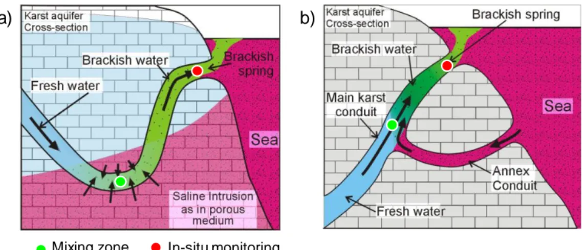
SGD to the sea at springs is usually brackish, with a varying salinity correlated to the groundwater flow rate. The brackish water comes from a mixing between the fresh groundwater recharged in the catchment area, and the seawater intruded at depth within the aquifer (called hereafter salt groundwater). The karst conduits allowing preferential flows play a major role in the saline intrusion mechanism. The deep salt groundwater that mixes with the fresh groundwater can flow by two ways (Figure 1): i) the main karst conduit connected to the submarine spring cross the saline intrusion wedge, and then diffuse flow from the matrix (salt groundwater) to the conduit (initially fresh groundwater) occurs (Figure 1a), or ii) the salt groundwater flows through karst conduits connected with the fresh groundwater karst network (Figure 1b). These two conceptual model of salt and fresh groundwater mixing are still very difficult to observe since in-situ data are often limited to wells observation, that are not necessarily representative of the aquifer behavior in karstic environment. In situ measurements at spring are usually the only observation available. In order to go insight into the saline intrusion observation in karst aquifer, we decided to record salinity, temperature and depth (CTD) time series during cave diving exploration in large, long and deep karst conduit. Indeed, when karst conduits connected to a submarine spring are large enough to be explored by cave divers, the in-situ CTD time series recorded at the spring over time can be compared to the spatial variation of saline intrusion within the conduit. It’s also a way to explore the places where salt and fresh water mix inland within the aquifer (see the two conceptual models in Figure 1).
Poster presented to EUROKARST 2018 – 02 to 06/07/2018 2
Figure 1: Conceptual cross-section of a coastal karst aquifer. a) Saline intrusion as in porous medium, with a saltwater wedge crossed by a karst conduit connected to the submarine spring. b) Saline intrusion by seawater preferential flow path in the karst conduit (“annex conduit”) connected to the main karst conduit discharging at the submarine brackish spring.
The case study proposed is located in south-east of France, near Marseille (Figure 2 & 3). It’s the Port-Miou regional aquifer, draining a large part of the Low Provence, and discharging to the sea in two main karstic submarine springs: Port-Miou and Bestouan. This case study is included in the French network of observation of karst (SNO Karst). The two submarine springs have been explored by cave divers and are each connected to a large karst conduit: 2000m long for Port-Miou and 2500m long for Bestouan (Arfib et Douchet, 2011). During several dives, cave divers transported a CTD probe, giving access to the observation of the mixing between fresh and salt groundwater. Moreover, two very deep dives in the Port-Miou karst, at -233m below the sea level, gave the in-situ observation of the saline intrusion in depth. To our knowledge, this kind of in-situ deep observation in the karst network has never been done until now.
Figure 2: Location of the Bestouan and Port-Miou submarine karst conduits explored by cave-divers in the Port-Miou coastal aquifer (Cassis, France), from the springs up to 2000 m inland. These results are compared with the CTD time series recorded at the Port-Miou underground laboratory (Figure 3), located 500 m inland from the submarine spring (Arfib and Charlier
Mixing zone In-situ monitoring
Poster presented to EUROKARST 2018 – 02 to 06/07/2018 3
2016). So we have a data base of two in-situ time series, that we will call hereafter: cave diver CTD measurements (spatial variation along the karst conduit), and spring CTD measurements (time variation in one point of observation, at the underground laboratory). Spring CTD measurements show that for each flood (related to rainfall in the recharge area), discharge and salinity variations are correlated, with a variable time lag, that draws a hysteresis plot on discharge VS salinity scatter plot. This time lag is a typical piston effect, i.e. the flush of the brackish pre-event water stored in the karst conduit and moving from inland to the sea. It constitutes a volume around 1.106 m3, confirmed by the data recorded during the cave diving. We show that the seawater intrusion occurs upstream the 2000 m long karst conduit explored from the Port-Miou submarine spring. The salt and fresh groundwater mixing in depth generates a brackish groundwater flow in the aquifer over several kilometers, flowing in the main karst conduit connected to the spring. The original new observations in depth show that the brackish water is still present at the deepest point reached, at -233m below the sea level.
This work shows that preferential deep flow in karst conduit exists below the current sea level down to several hundreds meters deep that may impact the groundwater salinity. Groundwater resources in coastal zones are then restricted in the sea-shore and inland in the deep part of the aquifer. A CTD in-situ monitoring of submarine springs can help to forecast the saline intrusion.
Figure 3: Schematic 3D view around the Port-Miou karst conduit References:
Arfib, B., Douchet, M., 2011. State of hydrogeological and cave-diving knowledge about the submarine rivers of Port-Miou and Bestouan (Cassis, France). In: Proceedings 9th Conference on Limestone Hydrogeology, 1–3 Sept. 2011, Besançon, France (in French).
Arfib B., Charlier J.B. (2016) Insights into saline intrusion and freshwater resources in coastal karstic aquifer using a lumped Rainfall-Discharge-Salinity model (the Port-Miou brackish spring, SE France). Journal of Hydrology, 540, 148-161. doi:10.1016/j.jhydrol.2016.06.010
Bonacci, O., Roje-Bonnaci, T., 1997. Sea water intrusion in coastal karst springs: example of the Blaz Spring (Croatie). Hydrological Sciences Journal 42, 89–100.
Drogue, C., 1989. Continuous inflow of seawater and outflow of brackish water in the substratum of the karstic island of Cephalonia, Greece. Journal of Hydrology 106, 147–153.
Fleury, P., Bakalowicz, M., de Marsily, G., 2007a. Submarine springs and coastal karst aquifers: a review. J. Hydrol. 339, 79–92.
Fleury, P., Bakalowicz, M., de Marsily, G., Cortes, J.M., 2007b. Functioning of a coastal karstic system with a submarine outlet, in southern Spain. Hydrogeol. J. http://dx.doi.org/10.1007/s10040-007-0215-8. Xu Z.,Basset S.W., Hu B., Dyer S.B. (2016) Long distance seawater intrusion through a karst conduit network in
the Woodville Karst Plain, Florida. Sci. Rep. 6, 32235; doi: 10.1038/srep32235.
Acknowledgements : This work was performed within the framework of the Port-Miou observation site, part of the KARST observatory network (www.sokarst.org) initiative from the INSU/CNRS, which aims to strengthen knowledge-sharing and promote cross-disciplinary research on karst systems. We also thank the Conservatoire du Littoral, the Calanques National Park and the Cassis city for the access authorization to the Port-Miou in-situ underground laboratory.

![[PDF] Cours QtCreator pour débutant en pdf | Formation informatique](data:image/gif;base64,R0lGODlhAQABAIAAAP///wAAACH5BAEAAAAALAAAAAABAAEAAAICRAEAOw==)