HAL Id: hal-02014081
https://hal.parisnanterre.fr//hal-02014081
Submitted on 11 Feb 2019HAL is a multi-disciplinary open access archive for the deposit and dissemination of sci-entific research documents, whether they are pub-lished or not. The documents may come from teaching and research institutions in France or abroad, or from public or private research centers.
L’archive ouverte pluridisciplinaire HAL, est destinée au dépôt et à la diffusion de documents scientifiques de niveau recherche, publiés ou non, émanant des établissements d’enseignement et de recherche français ou étrangers, des laboratoires publics ou privés.
The Late Natufian at Raqefet Cave: The 2006
Excavation Season
Dani Nadel, György Lengyel, Fanny Bocquentin, Alexander Tsatskin, Danny
Rosenberg, Reuven Yeshurun, Guy Bar-Oz, Daniella Bar-Yosef Mayer, Ron
Beeri, Laurence Conyers, et al.
To cite this version:
Dani Nadel, György Lengyel, Fanny Bocquentin, Alexander Tsatskin, Danny Rosenberg, et al.. The Late Natufian at Raqefet Cave: The 2006 Excavation Season. Journal of the Israel prehistoric society, Israel Prehistoric Society, 2008, 38, pp.59-131. �hal-02014081�
The Late Natufian at Raqefet Cave:
The 2006 Excavation Season
DANI NADEL1 GYORGY LENGYEL1,2 FANNY BOCQUENTIN3 ALEXANDER TSATSKIN1 DANNY ROSENBERG1 REUVEN YESHURUN1 GUY BAR-OZ1
DANIELLA E. BAR-YOSEF MAYER4
RON BEERI1 LAURENCE CONYERS5 SAGI FILIN6 ISRAEL HERSHKOVITZ7 ALDONA KURZAWSKA8 LIOR WEISSBROD1
1 Zinman Institute of Archaeology, the University of Haifa, 31905 Mt. Carmel, Israel 2 Faculty of Arts, Institute of Historical Sciences, Department of Prehistory and Ancient History.
University of Miskolc, 3515 Miskolc, Miskolc-Egyetemvros, Hungary 3 UMR 7041 du CNRS, Ethnologie Préhistorique, 21 Allée de l’Université,
F-92023 Nanterre Cedex, France
4 Department of Maritime Civilizations and The Leon Recanati Institute for Maritime Studies, University of Haifa, Israel
5 Department of Anthropology, University of Denver, Denver, Colorado, USA 6 Department of Transportation and Geo-Information Engineering, Technion –
Israel Institute of Technology, Haifa 32000, Israel 7 Sackler School of Medicine, Tel Aviv University, Israel
ABSTRACT
A long season of excavation took place at Raqefet cave during the summer of 2006. In the first chamber we exposed an area rich with Natufian human burials (Locus 1), a large bedrock basin with a burial and two boulder mortars (Locus 2), an in situ Natufian layer (Locus 3), and two areas with rich cemented sediments (tufa) covering the cave floor (Loci 4, 5). The latter indicate that at the time of occupation the Natufian layers covered the entire floor of the first chamber. During the ensuing millennia, these were washed away and/or removed by later visitors to the cave. We found in the cave and the terrace almost 80 human-made bedrock holes (most of which are commonly but somewhat erroneously termed mortars and cupmarks). Several contained in situ Natufian remains, and at the top of one a human skeleton was unearthed. The variety of the HBHs, in terms of shape and dimensions indicates that they were used in many ways, some of which could not have been for food or mineral processing. The paper provides results of on-going studies regarding the burials, the HBHs, the flint assemblage, the faunal remains, the ground stone industry, the bone tools and the beads. It also presents aspects of geoarchaeology and ground penetrating radar analyses. Some of the detailed plans and sections were prepared by the use of photogrammetry.
INTRODUCTION
This paper describes the second season (2006) of renewed fieldwork at Raqefet cave, as well as preliminary results of several laboratory ongoing analyses. Our previous report (Lengyel et al. 2005) included a description of the cave and the immediate setting, and these are only briefly repeated here. The cave is situated on the southeastern side of Mount Carmel, in an inner wadi very close to the low hills of Ramot Menashe (Fig. 1). The cave is located approximately 50 m above the wadi bed, facing west, at the bottom of a cliff. In front of the cave there is a narrow terrace immediately below the large entrance. Five chambers form the elongated cave; the rearmost has an open chimney.
The cave was discovered by Olami in 1956 (Olami 1984), and excavated by Noy and Higgs (1970-1972). The excavations exposed a sequence beginning in the Late Middle Palaeolithic and concluding with the Pottery Neolithic period. The Raqefet cave 2006 season of excavation focused on the Late Natufian deposits and features found in several parts of the cave and terrace. The 1970-72 campaign exposed in the first chamber Natufian remains that included burials, as well as bedrock mortars and cupmarks (henceforth human-made bedrock holes, HBHs, see below) (Noy and Higgs 1971).
In the summer of 2006 we excavated for six weeks. The aims of the renewed project are to study the complex of Late Natufian burials and bedrock features. This complex appears to be unique and very promising in terms of aspects regarding economy, culture, and social life during the transition from hunting-gathering to agriculture.
FIELDWORK
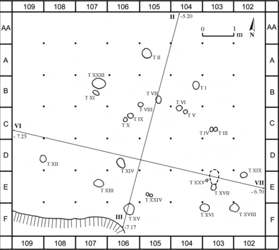
Fieldwork was carried out in the first chamber (Loci 1-5), at the entrance of the cave (a natural rock depression in square B5), in the innermost chamber (the chimney), and on the terrace in front of the cave (Figs. 2-16). A small adjacent cave was also tested. In the first chamber of Raqefet, most of the floor was exposed during the 70-72 campaign. In 2004 we cleaned the previously excavated area and exposed a little more of the floor. During 2006 we divided the floor containing Natufian remains into five loci, according to bedrock features and sediments (where present), and worked in all of them.
The Natufian loci were defined only in areas where soft or hard Natufian sediments were preserved. Excavation of the loci was carried out in units never exceeding 0.5x0.5x0.05 m. Where applicable, all soft sediments were sieved. The sediments from the burials and HBHs were wet sieved (2 mm) and large un-sieved samples were kept for future analyses. In many parts of the cave the Natufian bedrock features were covered by cemented sediments (tufa). These, in many places, contain Natufian flints and animal bones. Large samples were kept, and preliminary observations are presented below (see geo-archaeology section).
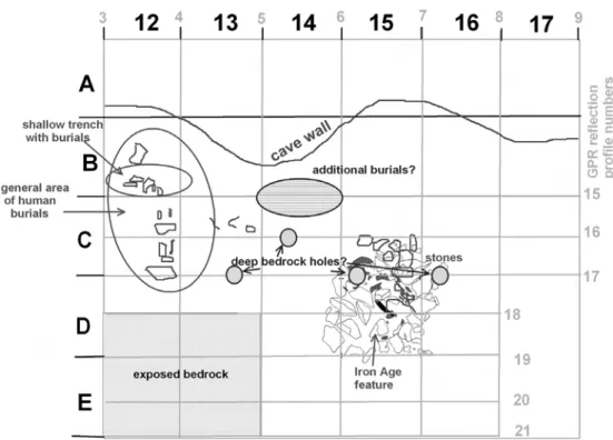
Locus 1
Locus 1 is located in squares B-C/12-13-14, near the northern wall of the cave (Figs. 3-5, 9). It was defined according to bedrock topography, and is confined to a large basin (basin #1) and its immediate surroundings where Natufian sediment was still preserved. It is in
Figure 2. General plan of the cave. Details of the first chamber are provided in Figures 4, 5. Location of studied area and sections through the terrace are given in Figures 6-8.
this area that four Natufian burials were found during the previous excavations conducted in the cave (Noy and Higgs 1971; Lengyel and Bocquentin 2005). The basin is composed of three elongated segments. The first is near the cave wall and parallel to it (square B11). The second is diagonal to the wall and contains a large slab with a cupmark on one side, and a deep human-made bedrock hole (see definition below) on the other (squares C-D/12). This segment is the richest place with Natufian skeletons so far excavated at the site. It was not excavated to bedrock yet. The third segment is again parallel to the cave wall, and its eastern side is still to be excavated (squares D/13-14). Cemented sediment covers much of the bedrock near the cave wall; thus the cupmark slab, stone implements, flints and human bones are incorporated in a hard solid deposit.
The locus was superficially cleaned during field season 2004 (Lengyel et al. 2005) in order to expose the level reached by T. Noy and E. Higgs at the end of their last campaign. Some stones were scattered on the top. A few of the stones were embedded in loose sediment probably removed in the 70’s; others were stuck in a hard unexcavated layer. Several sets of stones set on edge were found incorporated in the graves.
From the beginning of the dig two sedimentological units were defined according to colour and texture. The first is grey sediment filling a round pit (squares C12d, C13c). Artefact density was very low and included some potsherds. The pit had been partially exposed during
Figure 3. Photogrammetry in process. A 3D model of the cave floor (chamber 1) during preparation, looking west. Locus 1 is at the bottom right and Locus 2 is at the top center. Triangles indicate areas of work in progress.
the seventies and could be identified in section almost down to bedrock. The second unit is a thick reddish Natufian layer, soft in most places and cemented (rock hard) near the cave wall. This layer contained the burials and was very rich in artefacts such as flints, stone tools and manuports, animal bones and scattered human bones.
Locus 2
Locus 2 is a large, deep natural basin (basin #2) in the cave floor situated immediately at the opening of the cave (squares D-G/6-10; Figs. 4-5, 10-11), entirely filled with archaeological sediments. The basin is ca. 4x5 m across and it slopes westwards to a maximum depth of ca. 1 m. A tree grew here until 2004. The formation process of this natural depression is yet to be fully established. It is apparent, however, that both water running down the cave floor towards the lower entrance, and a small seasonal waterfall from the cliff above (the basin is adjacent to the drip line) probably carved and shaped the basin prior to Natufian occupation. The entire volume of the basin was excavated.
The basin is coated by a variety of hard deposits. These include cemented sediments containing animal bones and flint items. These probably result from the reaction between water running or collected in the basin, limestone (calcium), and organic materials. The surface of the basin is very smooth in some parts. Two large boulders (70-80 cm across) and a few smaller stones were standing at the cave entrance (over dark sediment), right at the edge of the locus. They may have been placed there by the Natufians or later occupants as a massive retaining wall, and it is less likely that they fell from the roof or rolled to their present position.
The fine sediments within the basin are mainly gray to brown in color, with restricted reddish patches. The latter are similar to the reddish Natufian sediments in Locus 1. A great degree of sediment mixture was noted in Locus 2. This should be attributed to post-depositional processes, including the impact of post-Natufian occupations at the cave. Two rodent burrows were also noted. The mixture of sediment made it impossible to distinguish between different layers and thus the material culture of this locus will be described as a single unit. At the basin bottom and mainly at its northwestern part, a yellowish formation was noted. It differs from the cemented sediment common at the first chamber in many respects, including morphology and texture. Yellow concretions were also noted within the archaeological sediments, but they are mainly found 0-50 cm above the basin bottom.
A variety of stones of diverse dimensions and shapes were found, especially at the top half. Flint artifacts (mostly tilted or vertical) were abundant, and groundstone tools and animal bones were also present. A few pottery shards of several periods were uncovered. A single human interment was found (H.12) as well as several isolated human bones.
At the southern edge of the basin, two adjacent stones are ‘stuck’ in the cemented sediment and it is possible that these are the continuation of a short stone wall found within the basin.
Figure 4. Topographic map of the cave floor (chamber 1). Grid frame in intervals of 1 m, contour intervals in 10 cm, prepared by photogrammetry (see text). Loci 1-5 (L.1-5), basins (B1-4) and large HBHs are marked. Note locations of sections I-II and III-IV (Figure 5).
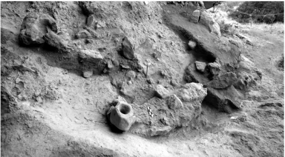
The wall runs from southeast to northwest, ca. 80 cm long and 10-20 cm wide, made of undressed stones, bearing up to 2 courses. The wall runs from the basin directly toward a large boulder mortar found in situ, broken in two. Adjacent to the stone wall, and slightly below it, a single, articulated human interment was found (H.12, see below, Figs. 10, 11). The position of this interment on the sloping wall of the basin supports the notion that it was buried in a grave dug into the Natufian sediments already filling the basin. H.12 was laying in the same orientation as the wall (possibly on the bedrock) to which it was adjoined, and it seems that its missing lower limbs were cut off by a sharp tool. Three Dentalium beads were found near the nose. The legs of H.12 were at the general direction of the large boulder mortar, and probably 10-25 cm north-west of its base before cutting.
Although the mortar is stratigraphically above the wall, its base is only centimeters above the top of the wall. The upper part of the mortar is almost at the same level as the floor of the cave (and the rim level of many of the bedrock holes), and thus it is possible that it was used as a bedrock feature. In order to set the boulder mortar with the top at the same height of the cave floor, a rather deep pit was dug and the mortar was placed in it, supported by small stones and backfill. Several slabs and rough stones were found north of the mortar.
The eastern edge of the basin is marked by a deep human-made bedrock hole found only 40 cm from the boulder mortar. The surface near it is smooth (tufa), suggesting that the floor surface has suffered from both erosion and the development of cemented sediments.
Another free standing boulder mortar was found ca. 1.5 m north of the first one. As is the case with the former, it seems that this was buried, its base supported with small stones and only its upper part exposed. Several heavily incrustated human bones were found near the
base of the mortar. It is possible that here, too, there was an association between a (badly preserved) burial and a boulder mortar.
Locus 3
Locus 3 is the eastern continuation of Locus 1 (squares C-D/15-16, Fig. 2), near the north cave wall. Only the top level of the locus was exposed by us, and as seen from its western section it is at least 0.5 m deep. It was divided into three sedimentological units.
Unit 1. The surface of the locus is covered by loose light brown-grayish sediment, with stones up to 40 cm long. Its thickness is between 10 and 30 cm. The stones are disturbed, originating in a structure belonging to Unit 2 (square D15). It contains a large quantity of potsherds of Iron Age II, fewer flints and bones. This unit cuts the floor of the structure in Unit 2 as a pit.
Figure 7. Perpendicular topographic sections of the terrace area (see Figures 2 and 6 for location). The enlarged area of fieldwork focus is presented in Figure 8.
At the bottom of the pit, masses of charcoal were found. The bottom was also burnt in a few places. The pit cuts into Unit 3.
Unit 2. It has the same matrix as unit 1, but is more solid and stones are found in only one stone structure. Potsherds are scanty (excluding the structure). The structure has three closed stone walls, with an area of ca. 1x1 m and a height of 30 cm. It is constructed of two rows of stones. The open side of the structure is facing NW. The stones were placed on each other without using any material for cementation. The floor of the structure is hard, made of clay, and also can be traced outside the structure on the western side. The thickness of the floor is ca. 2 cm. The clay floor is cut by Unit 1 right in the middle of the structure, in an area about 80 cm in diameter. The structure (Iron Age II, judging by the pottery) was built over an incomplete circular stone structure belonging to Unit 3.
Figure 9. Locus 1 during excavation (A looking northwest, B looking west-southwest). Note a large slab with a cupmark at one end, a large HBH at the other end, and the stones between the human skeletons.
Figure 10. Locus 2 during excavation. H.12 is immediately to the right of the broken boulder mortar (top left). Fragments of human bones were also found near the base of the second boulder mortar (center of photo).
Figure 11. Locus 2 during excavation, with H.12 in
situ. Note the sharp cut of the
Unit 3. The sediment is hard, reddish-brown (wet), yellowish brown (dry), and contains a few stones, flints, bones, and no potsherds. It also contains a circular incomplete stone structure. A few centimeters beneath the highest point of the stone structure, embedded in Unit 3, a Late Natufian surface was exposed, containing knapped stone tools, basalt grinding tools, animal bones, sea shells and bone tools. At this Natufian surface, the excavation stopped.
Locus 4
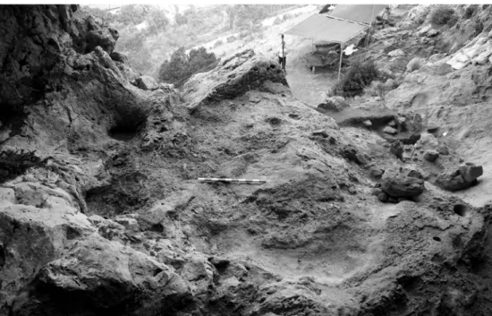
Locus 4 is a flat area above Locus 2, near the southern wall of the cave (squares H-M/5-10; Figs. 2, 12). An elongated arched bedrock basin (basin #4) is located at the eastern side. Much of the area is covered by tufa, and no soft sediment was preserved here. Along the higher southern and western edges this sediment reaches a height of 30-40 cm above the floor. Two round HBHs are situated near Locus 2, also covered by tufa (Fig. 13). Stones, flints, and bones are preserved in the sediment all over the area. Samples of the sediment were chiseled out in squares K7 and K9 for future analyses
Locus 5
Locus 5 is a long narrow niche at the southern side of chamber 1, separated from it by a steep high rock (squares K-L/11-15; Figs. 2, 14). A thick dung layer covered this area and was
Figure 12. Locus 4 during excavation, general view towards cave entrance and terrace (west). Basin 4 is at bottom center and Locus 2 on the right.
Figure 13. Locus 4, close-up view of section through the cemented sediment (tufa) with a large stone, bones and flints (scale in cm).
Figure 14. Locus 5 during excavation, looking east.
completely removed. A layer of tufa with high densities of flints and bones was thus exposed. This is topographically the highest cave floor in chamber 1, and the remains indicate that even this narrow place was used by the Natufians. A sample was chiseled out from square L14.
Feature in square B5
A small natural bedrock basin containing Natufian sediment was preserved at the northern side of the cave entrance, in front of the cave (Figs. 2, 15). It is lower than the floor of the first chamber, and covers almost one square meter. Reddish sediment filled the basin, reaching ca. 30 cm in thickness. It contained sharp flints and animal bones, and no potsherds.
The inner chamber (chimney)
The inner chamber has an area of ca. 4X7 m, and the only open chimney in the cave. Judging by the dip of the cave walls and the loose terra rosa soil, it is clear that the chamber has a bell-like shape, where sediments are filling it way above the widest point. The chimney is most probably open for a very long time, formed by the junction of several large cracks in the rock. At the lower and more concealed parts of the chamber, speleothems are still dripping even during the summer.
Figure 15. The B5 feature during excavation, with the natural rock basin and sediment still present in the northern section (vertical scale and horizontal arrow are 20 cm long each).
Many stones were scattered on the surface, including several boulders. These appear to have fallen through the open chimney, as is the case for the thick terra rosa layer. At the southern side of the chamber large stains of modern ashes were observed.
A 3x1 m east-west trench was excavated here (squares V/40-42, Fig. 2). The western meter (V/40) was only excavated to a depth of 5 cm, through a layer of modern ashes. The layer contained several white bones and no archaeological remains. In squares V/41-42 a depth of 1.2 m was reached (Fig. 16). The entire depth was composed of terra rosa soil rich with small stones. No layers were visible, though many pot shards were found throughout (dating to several historic periods, see below). Flint artifacts were rare. Small, non-fossilized rodent and bat bones were abundant, but larger bones were very rare.
The terrace
The terrace of the cave is narrow and steep, composed of several rock steps, with boulders and stones from the cliff and terra rosa as the local soil. Before our excavations, only an elongated east-west narrow rock was exposed in front of the entrance (west of the cave), as part of the top rocky step. On it were two round HBHs, one wide but shallow and another eroded type C HBH (see below). These contained modern cement used to anchor a modern
“Nature Reserve” sign. As the study of HBHs is a main goal of the Raqefet cave project, most of the first terrace step was exposed. Thus, tens of square meters were cleaned to bedrock (Figs. 2, 6-8, 23). Altogether twenty three HBHs were exposed on this step, and three small ones were exposed several meters to the south, on another steep rock surface (see location of TXX on Fig. 7). Many of the HBHs contain a grey tufa crust, in some cases cementing stones or flints into the feature.
There are no large or deep HBHs here (as are inside the cave). In addition, the distribution pattern is not clear, though several of the medium-size holes appear to form a loose arch along the rock edge.
The small southern cave
The Raqefet cave is located in a west-southwest facing cliff, on the east side of wadi Raqefet. The western slope of the wadi has no steep cliffs and no caves in the immediate vicinity of the site. However, within the eastern cliff, there are many small caves, crevasses and cracks. Some of the caves were visited by us, and only one is relevant here. The cave is located ca. 5 m south of Raqefet, at the same height and also facing west. It has no terrace in front of it, and the cliff here drops in several steep narrow steps. Its floor is a little higher than the floor of the main cave.
The cave ceiling is low, reaching maximum dimensions of ca. 2x4 m, with small narrow cavities present is some walls. When found, the entire floor was covered by a thick layer of guano, belonging to hyrax, birds, etc. At the entrance, on a small narrow ledge about 40 cm above ground level, one HBH is present. It is round with evidence of erosion. Top diameter is 25 cm and depth is ca. 30 cm. An area of 0.5 square m was cleared to bedrock in what seems to be the deepest part of the cave. Bedrock was reached at a maximum depth of 50 cm. No archaeological layer was visible. Several potsherds were recovered, with pieces from the Chalcolithic and Bronze Age periods (see below). Two pieces of flint were recovered. The largest is a proximal half of a broken blade, the second is a small flake.
If the bedrock feature is indeed Natufian (as it is very similar to some of the Raqefet specimens), it would imply that the Natufians knew this small cave, and even used it. Indeed, no layer was found in our test excavation, and this may be due to the small size and inconvenient dimensions of the cave. Alternatively, during later use of the place (by shepherds?) it may have been cleaned to bedrock.
THREE-DIMENSIONAL MAPPING OF THE FIRST CHAMBER (S.F.)
Apart from the conventional mapping of the archaeological features (using a general 1x1 m grid) we used photogrammetric mapping in the first chamber. The aims were a) to create a detailed 3D model of the cave floor, as the topography is very uneven and the concentration
of HBHs is high, and b) to provide a detailed topographic map of the same floor, in which the location, the setting and dimensions of the HBHs will be clear.
Based on the established 1x1 grid, close-range photogrammetric mapping provided dense and detailed information. For the photogrammetric mapping, the Nikon D-70s camera with a 24mm f/2.8 lens was used. About 450 images were acquired to facilitate the photogrammetric work. To allow photogrammetric mapping, multiple images of the same objects were taken from different views with sufficient overlap among them. The images can be categorized into the following scale classes: i) small scale images, for an overall coverage of the cave floor to establish an ancillary control network, ii) medium scale images, serving as the backbone of the mapping project by facilitating the measurement of 3D points in the cave and 3D rendering, and iii) large scale images, taken from short distances to allow the detailed mapping of features like small and deep HBHs.
To maintain high level of accuracy the camera was calibrated (to recover its intrinsic parameters – focal length, principal point, and lens distortions) before and after the imaging campaign. Because of the large volume of images and the numerical sensitivity of the simultaneous bundle adjustment solution (Kraus 1999), the mapping began with solving the orientations (pose and attitude) of the small scale images, for which more than seven control points were seen in each image (allowing a direct linear solution for each). Overlapping images then facilitated the measurement of 3D ground points towards which the medium scale images were registered, and from which detailed mapping of the cave floor was carried out. Following this scheme that limited the introduction of outliers, a simultaneous bundle adjustment solution was conducted. Because of surface roughness and irregularity, measurements were performed semi-automatically, where a point was measured in one image and based on coarse surface approximation and the constraints that epipolar geometry imposes, the point was correlated to other images. The medium scale photogrammetric mapping facilitated both the measurement of general topography of the cave and served (as the small scale images) for setting control to the detailed mapping of the HBHs and other objects. Those objects, especially the deep narrow specimens, posed a challenge for mapping as they are not well illuminated inside. For the measurement of the HBHs, key points that capture their 3D shape were marked so as to appear in all acquired images, thus allowing consequent extraction of their shape from the images.
The resulting cloud of 3D points was then transferred into Geographic Information System (GIS) software via which a Digital Surface Model (DSM) was formed. Information in the form of contour lines and profiles were extracted. Additionally, other geographic related information that was acquired throughout the survey, like sketches, was registered into the surface layer. This way a geospatial layered association of the information acquired was formed.
The results of the mapping presented here include a 3D model of the floor (Fig. 3), a topographic map of the floor (Fig. 4), and two cross-sections (Fig. 5). The accuracy of the mapping and cross-sections is on the order of +2 cm. An accurate 3D model of each HBH is now in preparation, and the combined results will be presented elsewhere (Brown-Goodman et al. 2008).
GROUND PENETRATING RADAR MAPPING (L.C.) Introduction
On June 24 (2006) ground-penetrating radar (GPR) data were collected in order to map three areas of the Raqefet Cave. The primary goal of the survey was to prospect for certain bedrock features that were visible on the exposed portion near the entrance to the cave (Fig. 17). These appeared to be HBHs, and so it was assumed that such features inside the cave,
Figure 17. Base map of the GPR grid on the cave floor in chamber 1, with the excavation grid squares. Some of these features are within the sediment package, some on bedrock, and others very close to the surface.
covered by sediment would be the target of the GPR surveys. There was also a portion of a skeleton exposed along the north wall of chamber 1 (Locus 1), which was an additional target. Inside the cave two surveys were conducted, one in chamber 1 where sediment covered the bedrock (scheduled for excavation in the summer of 2006) and one in the far recess under the chimney where unknown sediment layers were preserved. Additionally it was decided to test the method in a narrow terrace along the exposed apron of the cave, well outside the drip line. In this area the goal was to look for possible walls or other Natufian features on or in the bedrock surface that might be buried by slope wash sediment.
The Geophysical Survey Systems Inc. SIR-2000 system was used with the 400 MHz antennas and a survey wheel for distance calibration. Reflection data were collected with a time window of 50 nanoseconds inside the cave and 40 nanoseconds on the terrace. Velocity analysis using hyperbola fitting (Conyers 2004:99) showed that each nanosecond of two-way travel time represents approximately 5 cm in the ground, making a depth of energy penetration of 50 nanoseconds about 2.5 meters.
Surveys were conducted with a 50 cm transect spacing and the survey wheel was calibrated to collect approximately 33 reflection traces each meter, producing a very dense reflection data set along lines. It was found that all surveys had a small amount of survey wheel slippage, producing some error in the horizontal placement of reflection traces, which was greatest when the antenna was pulled over surface irregularities and in and out of holes in the bedrock.
Reflection data were processed into vertical reflection profiles, where reflection amplitudes were re-gained to enhance subtle changes in layers and features, and all traces in all profiles had a background removal filter applied to remove extraneous noise (Conyers 2004: 123). All GPR reflection profiles processed in this manner showed a distinctive reflection produced from bedrock as well as variations within the sediment package above. Each was interpreted in two-dimensions and correlated with what was known from excavations to hold significant buried materials. Reflection profiles that illustrate significant buried features in each of the grids collected will be discussed in detail below.
Chamber 1 Grid
Eleven reflection profiles were collected near the cave mouth (files 15-25) within a grid that was 8x5 meters in maximum dimension (Figs. 17-22). The northernmost profile (file 15) was collected as close to the northern wall of the cave as possible and its 0,0 origin tied to the datum in the southeast corner of excavation square B9. Transects were oriented parallel to the excavation grid already in place and all were oriented from west to east (after alternate profiles collected in a zig-zag fashion were reversed). For all transects the first 2-3 meters on the western edge of the cave were collected over exposed bedrock, and therefore those
portions of the profiles were of no use in mapping changes in sediments or variations in the bedrock surface itself. No topographic map of the cave surface was available at the time, and therefore profiles were not corrected for elevation variations, although it was recognized that there was up to 20-25 cm of variation in elevation along some transects due to the uneven surface of the cave floor.
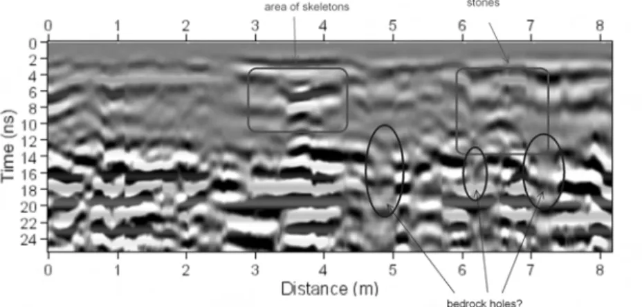
Reflection profile 15, the northernmost profile collected very close to the northern wall of the cave, shows a distinct bedrock reflection at about 18-20 nanoseconds depth in the middle of the profile (Fig. 18). The area of known burials within the sediment package overlying bedrock is not at all distinct in this profile, but in general the area appears to have a few reflection anomalies, perhaps associated with skeletal material. This profile demonstrates how indistinct human remains can be using the 400 MHz antennas, as they do not have the resolution capable of distinguishing small bones within a fine-grained matrix. A feature similar to the skeleton area is located between about 5 and 6 meters on this profile, whose origin is not known, but could be additional skeletal materials (Fig. 18).
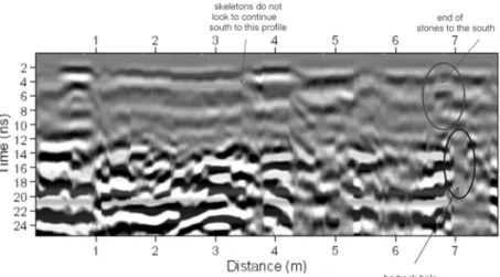
Profile 16 (just 50 cm south of profile 15) also shows the general area of skeletal materials as a high amplitude reflection (Fig. 19), but it is also indistinct with regard to the materials known to exist in this area from excavations. The Iron Age structure is visible as a high amplitude reflection in the uppermost portions of the profile. One interesting break in the bedrock, which is quite narrow (about 20-30 cm diameter at most) can be seen in this reflection profile, which is likely a HBH similar to those exposed on the bedrock near the mouth of the cave and which were excavated from under the sediment cover during the 2006 season. This bedrock feature was not immediately visible during the initial interpretation of this data set (Fig. 19). The narrow HBH is visible only as a break in the bedrock reflection and its depth cannot be determined as radar energy was attenuated within this narrow hole. Its location, and other similar bedrock breaks, visible in other reflection profiles are shown in Fig. 17.
Similar bedrock features are visible in profile 17 below (Fig. 20). In this reflection profile the areas of skeletons and associated rocks and artifacts can be seen as high amplitude reflections, but with little definition of individual objects. The Iron Age structure between 6 and 7 meters is also visible, with a distinct reflection hyperbola at about 10 nanoseconds (50 cm depth), which was likely produced from a buried rock below this structure.
It does not appear that the skeletal materials (as least as defined by high amplitude reflections) continue this far eastward in the cave. But they are indistinct at best, where they are known to exist, so this supposition cannot be made using GPR analysis alone.
Little of interest was visible in the remaining profiles in this grid (files 18-25). Those reflection profiles showed layered sediment, which could contain skeletal materials and small objects, which were only poorly resolved using the 400 MHz antennas. No bedrock features were visible in those profiles (Fig. 21).
Figure 18. Reflection profile 15 showing the location of skeletal materials excavated in 2006. Bedrock is the high amplitude reflection at about 18 ns from 2.2 - 7 meters.
Figure 19. Profile 16 showing the Iron Age structure and a HBH visible as a break in the bedrock reflection.
Back of Cave: Chimney Grid
All the GPR reflection profiles collected within the chamber below the chimney at the rear of the cave showed a distinct bedrock surface between 90 and 120 cm depth (about 18-22 nanoseconds), with sediment layers on top (Fig. 22). These five profiles were numbered 26-30 and all were 5 meters in length. No structures, truncation features or large rocks of any sort were visible with the 400 MHz antennas. The sediment layers in this recessed area of the cave appear to slope to the north, suggesting there was some accumulation of sediment into the cave sometime in the past as the cave floor was covered with material washed in from the chimney above.
Terrace Grid
Fourteen GPR reflection profiles were collected in this grid along the sloping terrace in front of the cave (Figs. 23-25). Bedrock was exposed just to the south of the grid and also to the south along the steep slope on the margin of the terrace. It was not known how deep the preserved sediment might be on this slope at the time the GPR data were collected. It was presumed that the bedrock surface buried by sediment would contain features such as were visible in exposures nearby. Possible walls or other features on bedrock were also hypothesized to exist under the sediment cover. The grid of reflection profiles consisted of lines of differing length in order to cover as much of the area as possible (Fig. 23).
Figure 21. Profile 18 showing the distinct HBH that truncates the horizontally layered sediment in the cave. It is filled with sediment of a different type and continues to the bedrock floor of the cave. Additional HBHs within the bedrock are also visible.
Figure 22. Profile 27 illustrating bedrock at 18-20 ns with sloping sediment layers above.
Figure 23. GPR Terrace grid showing reflection profile locations on the excavation grid with later exposed HBHs shaded.
High amplitude reflections that were hypothesized as walls were visible when the GPR reflection data were interpreted directly after their collection in July 2006. In light of the excavation results, these initial interpretations proved to be erroneous. Instead what was found was a complex bedrock surface that sloped down, as predicted. However, a noticeable raised bedrock ridge occurred in the middle part of the terrace, and then bedrock sloped downwards again to the south, which provided a “lip” to catch and preserve the sediment on the terrace (Fig. 24).
A GPR reflection profile along the northwestern portion of the grid shows this distinct ridge as a high amplitude reflection (Fig. 25). The bedrock reflection is also visible below the sediment cover. This same general configuration of bedrock was visible in all reflection profiles within the grid. As can be seen in Figure 24, the bedrock surface is very complex in this area, and a number of cracks and holes are visible. This complexity was also visible in the GPR reflection profiles. One interesting profile did show one of the HBHs, noted as XIV in GPR Figure 23. This HBH was quite visible on the bedrock surface (Fig. 25) at exactly the location shown in Figure 8, from which the annotations in Figure 23 were derived.
In general, these GPR reflection profiles on the terrace show some of the features that were later exposed in excavation, but most were quite complex. What were thought to be
Figure 24. Photograph of the terrace after excavation (August 2006). A noticeable bedrock ridge is located in the western portion of the grid.
walls in the initial interpretation turned out to be the bedrock ridge and other complexities in the bedrock below the sediment, many of which were later exposed and are visible in Figure 24.
Conclusions
Much of the analysis of the GPR reflection data collected at Raqefet Cave was done after a good deal of information about the subsequent excavations was available. This allowed features known to exist to be looked for in reflection profiles, and interpreted “after the fact”. A direct correlation of the placement and size of those known objects, stratigraphy and bedrock mortars with the GPR reflections showed that some very subtle features, not visible during an initial analysis in July 2006, were in fact visible. For instance, the bedrock ridge on the terrace was initially interpreted in 2006 as a wall (which was one of our initial working hypothesis of possible features that might be found there). Only after excavation was this elevated feature determined to be a natural bedrock ridge. Also, the narrow HBHs visible in many profiles within the cave were overlooked in the initial analysis, as they were too small and subtle to have caught the eye.
The GPR reflection data collected both inside and outside the cave were in excellent quality, with a depth penetration of more than 2 meters and good resolution. The project suffered somewhat from an inability to correct profiles for surface topographic variations, but not so much that buried features were still not visible. The 400 MHz antennas provided a fairly high resolution of strata, objects and the bedrock surface, but still tended to blur the processed images somewhat. Future work of this sort would benefit from the use of a higher
Figure 25. A HBH is visible in this profile as a subtle break in the bedrock reflection, just to the right of the high amplitude bedrock ridge at 2 meters.
frequency antenna system providing much greater resolution, but will necessitate a closer transect spacing. Those reservations aside, a number of interesting cave features were still visible in the GPR reflection profiles that remain to be uncovered including a large HBH(?) with at least two objects in it, and numerous small HBHs within the bedrock. Skeletal material and small associated stones and other objects could not be defined within the sediment matrix of about the same size and composition. Perhaps higher resolution data might better define these human remains.
GEOARCHAEOLOGY (A.T.)
During the 2006 field season the main goal of a geoarchaeological research was to test the contents of the Natufian HBHs. Many of the unearthed HBHs contain strongly cemented materials, and so we employed micromorphology as the key analytical tool to identify the composition of infillings, as well as post-depositional changes of the deposits. Micromorphological investigation included preparation of standard petrographic thin sections after impregnation with a polyester resin + acetone under vacuum. Impregnation lasted four weeks. Thin sections were described according to Bullock et al. (1985) and Courty et al. (1989).
Thus far we investigated the “twin” HBHs CI-II and HBH CXXIV (Figs. 4, 5). It is necessary to state that micromorphological studies of other HBHs is underway, hence the results obtained thus far are treated with caution. Future studies will shed more light on the problem of HBHs use and their possible post-depositional modifications since burial.
HBH CXXIV is a large feature located almost in the middle of chamber 1. It has several natural cracks crossing it, and its surface is strongly eroded. A long thick root from the tree growing in basin 2 (Locus 2) was found here during the 2004 excavations. The top of the HBH contained loose sediment extremely rich with small bones (microfauna). The bones are white and appear to be modern, most probably accumulating under a nest of a raptor.
At the bottom of the HBH, a hard layer was found which consists of two sub-layers. The upper one is white, cemented, with numerous brown speckles, ca. 1 cm thick. The lower one is also white, with some gray brown dots and speckles, ca. 1 cm thick. In thin sections the upper sub-layer appears as a dense non-aggregated and relatively heterogeneous calcareous matrix, composed of both micritic and microsparitic areas, with porosity that varies from 50% to 20% (Fig. 26a), and abundant 50 µm through 500 µm brown – almost isotropic inclusions – of primarily soil pellets embedded within the matrix (Fig. 26b). Some of the larger clayey soil inclusions contain well preserved fresh vegetal remains of amorphous nature, either with rounded cellular structure (Fig. 26c) or elongated filaments (Fig. 26d). The lower sub-layer is much more homogeneous due to the lack of clayey soil aggregates
and more frequent unburnt small bones. In addition, strongly burnt wood charcoal ca. 0.7 mm thick is scattered in the matrix. The charcoal pieces are intimately mixed with the matrix, so that only carbonized filaments of presumably woody vegetation are preserved.
HBHs CI-II show a different microfabric with no distinction on a sub-layer level. Thin sections demonstrate the high number of dolomitized limestone pieces ranging between 5-12 mm which are intimately embedded in the matrix (Fig. 27a). The largest rock piece, ca. 1 cm size, has a rectangular shape, completely lacking any roundness. The rocks are definitely derived from the roof of the cave. The calcareous matrix, in contrast to sample CXXIV, has a brownish color; it is strongly heterogeneous and aggregated into 0.1-0.2 mm rounded peds of various hues and compositions (Fig. 27b). Rounded peds are mostly reworked terra rossa soils (Fig. 27c) and strongly reworked bone fragments, both calcareous-free, constituting up to 40% of the total mass. They are intimately mixed with brown calcareous aggregates whose shape is less clearly delineated. The peds are coated with subsparitic calcite. Porosity is
Figure 26. Photomicrograph of thin sections from mortar CXXIV; A. plane polarized light (PPL); B. crossed polarized light (XPL); a – heterogeneous, vesicular, calcareous matrix with brown clayey soil aggregates (PPL) magnification 4x10; b – the same (XPL), magnification 4x10; c – vegetal remain, unburnt (PPL), magnification 10x10; d – fibrous vegetal remains embedded in a red soil (PPL), magnification 4x10.
about 30% and is represented primarily by vughs, although few biochannels, resulting from post-depositional insect churning also occur. A clear indication of burnt materials is provided by elongated and strongly charred pieces of wood with no cellular structure preserved (Fig. 27d).
In sum, our observations show that the infill of the HBHs so far studied is not identical. The infill of CXXIV represents a strongly compacted, albeit vesicular, calcareous ash, probably originating from wood, as evidenced by characteristic charcoal in the lower layer. Significantly, the upper layer, although also related to ash, contains unburnt vegetal remains, which were probably preserved due to the fact that they were incorporated into clayey soil material before final heating. The soil material, in contrast to the ash, contains red clay and abundant quartz and heavy minerals in silt-sized grains, of local terra rossa soils. Taking into
Figure 27. Photomicrograph of thin sections from mortar CI-II; all plane polarized light (PPL); all magnification 4x10; a) limestone rock (left corner) embedded in the brownish slightly pelletal material; b) gray calcareous matrix with reworked yellowish bones and brown soil aggregates; c) a larger soil aggregate embedded in the dense aggregated matrix; d) charred wood (?) fragment (left) in a porous matrix containing chips of bones.
account the presence of thousands of recent microfaunal bones which were encountered in the top layer of the HBH (see above), we refrain from final interpretation of the infilling, given the possibility of contamination with recent elements. In contrast, the infill of CI-II does not contain larger terra rossa aggregates with fresh organic materials. Charred pieces are few and no cellular structure preserved. However, the matrix itself contains abundant isotropic and partly weathered bones which were rounded apparently in the course of either colluviation or some other strong post-depositional process.
THE NATUFIAN BURIALS (F.B.)
The remains of eight individuals were found during this campaign (Table 1), mostly in Locus 1 (Figs. 3, 4, 9). For avoiding confusion with the skeletons found previously (four burials and one cluster of leg bones), we numbered them Homo 6 - 13. Homo 6 (sq C13a/C13b) is a child that was lying directly on the bedrock, on his right side with the knees in a flexed position, slightly straightened against the cave wall. The skeleton was found directly beneath two large flat stones lying on the surface that was cleaned in 2004. This area of Locus 1 was disturbed by numerous tree roots and, consequently, the upper part of the grave was filled with loose sediment. Thus, it is uncertain whether the two stones were contemporaneous with the burial. However, a third stone, lying directly on the head of the child was definitely associated. The lower part of the grave was heavily brecciated and the skeleton was taken out as a block.
Homo 7 (sq B12c/d) is a very fragmentary child with only part of the skull, mandible, clavicle, scapula, head of the humerus and cervical vertebrae preserved. The bones were found in their anatomical order, the face almost facing the ground. This assemblage is most probably the remains of a disturbed burial (later cut from the shoulders to the feet); it was also eroded at the top, as the skull vault is incomplete. A flat stone was found directly on top of it but considering the level of erosion, it must have been posterior to the grave.
Homo 8 (sq B12c) is an adult. The skeleton is fragmentary but enough is preserved to determine that the corpse was lying on its back, the left hand on the pelvis and the right hand under the left elbow. Concerning the lower limbs, only the right femur was found in situ, and it was in extension. However, considering the inventory and the location of the isolated pairs of fibulas and tibias found in sq C11 by Noy and Higgs (Lengyel and Bocquentin 2005: 279), it is very likely that those bones belong to Homo 8. In this case, the corpse was deposited with both legs extended, a position quite unusual for the Late Natufian and more frequent in context of Early Natufian cave burials.
Homo 9 (C12c/d) is an adult in a fragmentary condition. The left half of the upper skeleton is preserved. The ribs, scapula, humerus, radius, and ulna are connected; the clavicle is also close to its anatomical position. The body is obviously lying on its back, forearm extended
along the body. The burial was later cut and partly eroded by a small pit (filled with unit 1 sediment, see above). A major question remains unsolved, as a skull and a mandible were found articulated right under the ribs in a reverse position. As the vertebrae are absent it is hard to relate the head to the skeleton. It might be part of the same individual and in this case the corpse was buried with the neck already partly disarticulated (cut deliberately?). A second hypothesis is that the corpse was deposited directly on the head of another individual, and later his own skull and mandible were removed. Further analysis of the bones may help clarify the issue (cutmarks, coherence between post-cranial and skull, DNA analysis).
Homo 9 cut a double burial (sq C12d) where Homo 10 and Homo 13, two children, were buried together. Homo 10 was found directly overlying Homo 13. Apparently both were buried in the same position on top of each other but only Homo 10 was unearthed last summer, Homo 13 was left in situ after its rib cage was discovered right under the rib cage of H10. Only the upper part of Homo 10 is preserved. The skeleton is lying on its back, the left forearm extended along the body; the right humerus is connected to the scapula, but cut at midshaft by the burial pit of Homo 9. If the cervical column is partly articulated, the axis was found far away on top of the ribs and the block atlas-skull-mandible was also moved to the north-west. A big stone was placed on the top of the neck and another on the head.
This disturbance was made during the decay of the corpse as the skull and atlas were still articulated (this is one of the latest articulations to decay) when it occurred. This short time span between the burial and the unsettling of some bones lead us to suggest that it might have been deliberate, maybe part of a secondary funerary treatment.
Homo 11, a very young child, was found further east (sq C14c/D14a; Fig. 28). The skeleton was discovered with all bones compacted and calcified together with the skull up-side-down. The hands are preserved in articulation, indicating a primary burial. The subsequent disturbances, probably due to taphonomic processes, will be discussed after laboratory analyses.
Another skeleton (H12) was found in Locus 2, (sq G8b/c; Fig. 11). This adult was lying on his back, knees brought up to the chin, left hand placed under the chin. The skeleton is heavily calcified. It was embedded in grey sediment, near a large boulder mortar, though with unclear stratigraphy. The lower half of the skeleton was cut very sharply at midshaft of the femurs and tibias, as well as the lower vertebrae.
Isolated human bones, most of which are heavily calcified, were found near the second boulder mortar, at the north of Locus 2.
Table 1: The Raqefet Cave 2006 skeletons.
Individual Age Locus Position and orientation
Homo 6 child 1 Lateral R; E-W
Homo 7 child 1 Head facing ground; NE-SW Homo 8 adult 1 On its back; E-W Homo 9 adult 1 On its back; W-E Homo 10 child 1 On its back; W-E
Homo 11 infant 1 On its back
Homo 12 adult 2 On its back; SW-NE Homo 13 child 1 On its back; NW-SE
Taking into account all Natufian graves found so far at Raqefet, there are at least 11 individuals grouped together in Locus 1. This area of the cave was repeatedly used for burials. A clear preference for burying the dead on their back in an east-west or west-east orientation is noticed. Funerary treatments of the corpses appear to be varied, and laboratory analyses are necessary for a more elaborate interpretation. Disturbances of the graves are very frequent and are due to the succession of inhumations in the same place. Furthermore, additional activities related to the dead took place in this part of the cave, and their exact nature is yet to be established.
THE HUMAN-MADE BEDROCK HOLES (D.N.)
The term “human-made bedrock holes (HBHs) is used to include the entire range of holes carved into bedrock. We are confident that some of these were never used as mortars or as any kind of pounding/grinding/crushing device, or even for quarrying flints (Grosman and Goren-Inbar 2007), as there is no bedrock containing flint in many of the sites. We thus prefer a neutral term to describe the wide range in terms of dimensions and shapes (and thus avoid the use of mortars, cupmarks or cupholes for describing the entire range of bedrock features, these should only be used for specific types, see below and Nadel and Lengyel n.d.; Nadel et al. n.d.). It should be noted that for the portable objects, due to lack of better terms, we still use the traditional nomenclature. At Raqefet cave, HBHs are found all over the floor of the first chamber, on a huge fallen rock in the second chamber, and on the narrow terrace in front of the cave (Figs. 3-5, 6 and Table 2; see below typological description). Altogether, the Raqefet HBHs comprise one of the largest Natufian assemblages (N=77), and so far the largest from any known cave in the region.
Table 2: The types of human-made bedrock holes at Raqefet cave and terrace (see text for breakdown of types).
Type Description Cave Terrace TOTAL
A Small, round shallow holes, 2-5 cm across and 2-5 cm deep, width:depth=+1
2 2
B Small, round shallow holes, 5-10 cm across, 2-5 cm deep, width:depth>1
2 2 4
C Medium round holes (cupmarks), usually bowl-like in shape, 10-15 cm across, 5-10 cm deep, width:depth=+1
13 11 24 D Large round holes (cupmarks), usually bowl-like in shape,
15-30 cm across, 5-30 cm deep, width:depth=+1
22 13 35 E Deep narrow round cylinders (mortars), 10-20 cm wide
along most of the shaft and very narrow at the bottom, 20-80 cm deep, width:depth<1
3 3
F Deep narrow round cylinders, funnel-like in shape, 10-20 cm wide along most of the shaft and very narrow at the bottom, 20-80 cm deep, width:depth<1. A clear shoulder/ break is present between the wider top and the narrow bottom
2 2
G Deep wide round/oval cylinders, wider than 20 cm, 20-80 cm deep, the top is much wider than the bottom
5 1 6
H Oval shallow features, width:depth>1 1 1 I Elongated features, including short "channels", width:
depth>1 (The specimen here is connected to a cupmark and not counted separately)
*1 *1
J Composite sets, of a pair (or more) combined together K Varia (specimens that do not fit any of the above categories)
Preservation
Sophisticated technology was used in order to manufacture the high quality and symmetrical holes. Direct evidence for the technology used in stone carving is rare at Raqefet. Massive erosion and a variety of crusts and tufas commonly obliterate the original rock surface. It is possible that the heavy weathering of the rock obliterated several small HBHs beyond definite recognition. Interestingly, some features were carved where a crack in the rock was already present, maybe to save energy. A similar phenomenon was observed at other sites, such as Rosh Zin (Nadel et al. n.d.).
Typology
The evidence for human-made modification, use and even carving into the bedrock is divided into two main groups, namely basins and HBHs.
Basins. Four large basins in the first chamber have evidence of use and/or modification (Figs. 3-5). Basin 1 is composed of three adjoining segments. In the northwestern segment (square B11), several stones were set on edge and a body was placed on top (Lengyel and Bocquentin 2005). The middle segment (in squares B-D/12) contained most of the Natufian skeletons found so far at the site (Locus 1). A limestone slab with a cupmark was set at the northern end and a large round HBH was hewn in the southern end. The southeastern segment of this long basin is only partially excavated (square D13).
Basin 2 (Locus 2) is the largest and deepest depression in the chamber, just inside the drip line. It is almost round, and was completely excavated. Two large standing boulder mortars and the remains of a Natufian in situ burial were encountered. Basin 3 is the smallest of the four, sub-rectangular in shape. It has two large HBHs within it (CI-II), both containing in situ Natufian remains. Basin 4 has two circles of chiseled areas on its floor.
The use of natural bedrock depressions/basins for burial is known from the el Wad (Garrod and Bate 1937: 7) and Hilazon Tachtit (Grosman 2003) caves. It is also suggested that at Hilazon Tachtit (ibid.) and at Raqefet the Natufians modified natural depressions into more regular basins.
Human-made Bedrock Holes. The cave floor is undulating, and the HBHs are located everywhere, including uneven surfaces. Some have very uneven rims. There is a wide variety of types, and they are grouped into categories according to size and proportions (e.g., Figs. 4-5, 29-31). As stated above, the variety of shapes and dimensions vary (and hence the possible past functions), and thus a neutral term, HBH, for the entire range is adopted here (Nadel and Lengyel (in press). It should be noted that there is certain continuity between some of the types, and that the boundaries between these are somewhat arbitrary. Also, some types have been observed in other sites and are absent at Raqefet (Table 2).
Figure 29. Plan and section of HBH XXIII, the largest in the site. Note the stone set on edge near the eastern wall.
A detailed description of all HBHs will be provided elsewhere. It should be noted, however, that stones and flint cores were found in some. For example, CI-II contained a high density of cores (N=69), with core frequency much higher than typical for a Natufian assemblage (Lengyel et al. 2005).
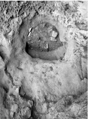
A deep narrow HBH (CXVI) contained a firmly wedged stone half way down (Figs. 30, 31). Below it were several small bones, 3 complete lunates, 3 blade/lets and 2 millimetric flints. Another stone was found near the top of HBH CXXI.
There are four wide and deep HBHs in the first chamber. One of them (CXXIII) is the largest HBH known from any Natufian site (Fig. 29). Another (CXLIV, Locus 1) contained at its top a skeleton of an adult (H.9). The latter, as well as HBH CI-II, were carved within elongated basins.
Twenty-seven HBHs were found on the terrace rock exposures. These are mostly of types C and D, as small holes were not recognized and only one feature was large enough to be identified as type G. The presence of crust (tufa) in many of them is noteworthy, and stones consolidated into cemented sediments within them are also present. One HBH was found at the entrance to an adjacent small cave.
Five HBHs (termed there bedrock mortars) were found at the terrace of el Wad, hewn into a leveled surface (Garrod and Bate 1937: 10-11). Several "bedrock cupmarks" were found in the vicinity of Hayonim cave (Belfer-Cohen 1988a: 167). There are also several HBHs at the
entrance to the Nahal Oren cave. At Hatula there are hundreds on rock exposures above the dwelling area (Grosman and Goren-Inbar 2007; Samzun 1994). However, their types (mostly medium size "cupmarks") and the presence of PPNA structures at the site suggest that they belong to the PPNA. At Huzuq Musa (Lower Jordan Valley) there are tens of HBHs (Eitam 2005: 686-689). On typo-technological characteristics of the flint assemblage the site is dated to the final Natufian, or to a succeeding transitional Lisanian phase (Winter 2005).
At Rosh Zin eighteen HBHs were documented (Henry 1976). A recent visit to the site revealed several additional specimens (Nadel et al. n.d.). There are three basic types, namely
small shallow cavities (type B), medium-sized holes (types C and D) and deep narrow features (type E, five of which contained a stone purposefully jammed into the shaft). At Saflulim there are more than 150 HBHs (Goring-Morris et al. 1999). The variety includes small specimens and deep narrow holes. Several dozens of similar installations are present in the nearby Romam and Rosh Horesha sites, which could be viewed as part of one large complex. At Upper Besor 6, an Early and Late Natufian site, there are Early Natufian HBHs used also by Late Natufian occupants. Three appear on the published plan, and several others were found on nearby rock exposures (Goring-Morris 1998). At Wadi Mataha (Edom mountains, southwest Jordan) “several bedrock mortars are present on a sandstone ledge… the deepest mortars (up to 72 cm) are grooved from heavy use”, probably Late Natufian of age (Janetski and Chazan 2004: 164). According to the figures, there are 8-10 HBHs (Ibid: Figs. 3, 6). The variety and density of the Raqefet cave and terrace HBHs is one of the widest documented so far. As such, their detailed description will be provided elsewhere (and see discussion).
Figure 31. Top view of the jammed stone in HBH CXVI (see Figure 30). Note the erosion of the walls near their top.
THE STONE ASSEMBLAGE (D.R.)
A large array of bedrock installations is exposed at the site, while a relatively small assemblage of portable groundstone (henceforth stone) implements was retrieved. The latter were found in Loci 1-3, the terrace and on the surface in several locations (Figs.32-34). A short summary describing the stone assemblage follows, while detailed analyses will be presented in the future.
Figure 32. Stone objects from the 1971/2 excavation. 1-5: shaped elongated limestone pieces; 6: a broken basalt celt.
The assemblage includes ca. 40 stone tools, as well as a considerable number of pebbles, cobbles and fragments bearing modification marks, mainly flaking scars. Most of the items are broken. The most common raw material is limestone, seemingly of local origin. Other raw materials include fine-grained and porous basalts as well as unidentified rocks.
Lower pounding and grinding implements include several free standing mortars, and the so called ‘pipe-mortar’ or ‘boulder mortars’, similar to items found in Nahal Oren (Stekelis and Yizraely 1963: 11, Pl. B-C), Hayonim Terrace (Valla et al. 1991; Valla 1995) and Jericho (Dorrell 1983: 489, pl. 1:a). One of these (# XVIII) was found standing in Locus 2, supported by small stones and adjacent to H.12. It is made of limestone and ca. 60 cm high, with one broken piece still lying juxtaposed to it. Another somewhat smaller but complete limestone boulder mortar was set about 1.5 m. from it. A few other cupmarks and smaller mortar fragments were also found, typically made of limestone.
Upper, mobile implements include pestles and burnishers. The few pestles found are of various subtypes, including cylindrical and conical items. One of these is a typical elongated
Figure 33. Stone objects from the 2006 excavation season. 1: limestone chisel/gouge; 2-3: shaped limestone pieces; 4: limestone bifacial tool from Locus 2.
conical Natufian pestle (Rosenberg 2004; Wright 1992); it was found in a mixed deposit on the terrace. This is a pointed proximal end fragment (opposite the active edge) made of fine-grained compact basalt, with a round cross section. Burnishers include various pebbles usually shaped by use only. These are made of limestone and are small, bearing one or two active faces.
Three grooved items were also found, all are made of fine grained basalt (Fig. 34). Two are fragments on faceted pebbles, and one is complete and made on an oval flat pebble. One
of these may have been operated as a burnisher also. All three bear polishing on their groove, mostly on their central parts. All grooves have a U-shaped cross section.
Two fragments of bifacial tools come from mixed/disturbed provenance. One is an axe made of fine grained compact basalt and the other is a limestone adze. A spindle whorl was also found in a disturbed context (and is probably not Natufian). A complete rectangular lower grinding stone or quern made of porous basalt was found in the Iron Age structure in Locus 3.
The stone assemblage of Raqefet cave is still under study. It is clear, however, that the assemblage is similar in many respects to other assemblages found in Late-final Natufian sites (Grosman 2003; Weinstein-Evron et al. 2007; Valla et al. 1998, 2001; Wright 1992). This assemblage, albeit small, represents different aspects of Natufian mundane and spiritual life. The meager number of stone pestles is puzzling when compared with the high number of HBHs. While this may suggest different utilization of the bedrock utensils, it is possible that wooden pestles were also used. The fact that many of the stone tools found in the cave were retrieved from burials and loci associated with burials, may suggest that their function was related to their context, namely as symbolic items and not as utilitarian implements.
THE FLINT ASSEMBLAGE (G.L.)
The Natufian assemblage presented here derives mostly from Loci 1 and 3 (excluding artifacts from unclear contexts). A total of 2973 knapped specimens from these two loci were analyzed, with similar samples from both loci: 1477 from Locus 1, and 1496 from Locus 3. In addition, a small lithic sample from the cemented sediments in Loci 4 and 5 (N=45) was retrieved by breaking the hard sediment with chisel and hammer. The latter sample, being small, was not studied to the same level.
Raw materials
Raqefet cave is situated within a Turonian Bina formation that consists of limestone, marl, and dolomite (Map of the Israel Geological Survey [MIGS]; see Fig. 35). This formation rarely contains flint (Delage 2001; Olami 1984). In the immediate vicinity of Raqefet cave (ca. in 500 m radius) flint outcrops were not observed.
The raw materials of the assemblages were grouped according to their visible features: texture and color. In addition their quality is classified on a threefold scale: low, mediocre, good. The quality classes are based upon the texture of the flint (Lengyel 2005).
Ramat Menashe (RAM) is the closest flint source to the cave, situated south of the cave, about 1.5-2 km away in the Adulam Lower-Middle Eocene geological formation consisting of chalk and chert (MIGS; Fig. 35).
Figure 35. The geological map of the Carmel (modified after the Map of Israeli Geological Survey: MIGS). ßm, Miocene basalt; ßuc, Upper Cretaceous volcanic rock units, basalt, gabro, ultramafics/ pyroclastics and flows; c1, Albian-Cenomanian Yagur and Kammon formation; c2, Cenomanian Deir Hannah formation; ea, Lower-Middle Eocene Adulam formation; emr, Middle Eocene chalk, Maresha formation; et, Lower-Middle Eocene limestone chalk and chert, Timra formation; p, Pliocene Bira and Gesher formations; q, Quaternary alluvium; qh, Quaternary red sand and loam (hamra); qk, Quaternary sandstone (kurkar); sp, Senonian-Paleocene chalk, Mount Scopus group; t, Turonian Bina formation.
Flint is abundant in this formation. It can be found on the surface in large blocks of up to 50 cm long, with an oval or irregular shape. The flint is characterized by grey and grayish-brown colors which enclose white patches and rarely dark-grey or almost black spots. The flint is fine grained, although calcareous inclusions are relatively frequent in its inner part. In some cases there are small white dots, and under the cortex there is a dark colored band. In certain specimens cracks and diaclase surfaces interrupt the homogeneity of the flint.
The Deir Hannah formation (DH) is located about 2-2.5 km from Raqefet cave. It is of Cenomanian age and consists of limestone, dolomite, marl, chalk and chert (MIGS). It is rich in flint (Delage 2001), which can be found in small (5-8 cm) oval nodules. The flint is characterized by brown and yellowish brown color, with fine grained and homogeneous texture. In some rare cases there are circular inclusions (smaller than 1 cm) that are, in texture, a bit less fine grained. Frequently small white dots are observed in the raw material, which might be the result of patination. There are specimens that are slightly translucent; a translucent and non-translucent composition can be observed even within one piece. The appearance can sometimes be slightly glossy.
The flint source near Daliyat el-Carmel (DC) is situated about 4 km from Raqefet cave in the Turonian Bina formation. The raw material of this formation can be found in 10-20 cm large oval nodules also in the Galilee (Delage 2001). It is a grey or grayish-brown coarse grained flint. Its texture is homogeneous. It has a very thick cortex in comparison to other raw materials.
A flint source in the Cenomanian Deir Hannah formation is situated in the north bank of Nahal Mearot (NM) (Weinstein-Evron et al. 2003), about 7-8 km from Raqefet cave. The source yields flints of various dimensions, even in 30 cm large nodules. This raw material is a light-grey colored fine grained flint with blue and purple hue. It is a bit translucent and contains small deep purple or dark fossils scattered in the material. Its texture is homogeneous.
Shamir formation flints of Nahal Galim (SH) are found a little further to the north, about 13 km from Raqefet cave. Here, high quality flints can be found in a variety of shapes and size. The Mount Oren Shamir formation flint has finer texture than that of the Nahal Galim (Weinstein-Evron et al. 2003). The flint found at Raqefet is a fine grained brown flint with homogeneous texture.
Locus 1
The assemblage from Locus 1 includes all knapping stages. The most abundant flint product is the flake, though bladelet cores are almost twice as common as flake cores (Table 3). Bladelets make up the next most abundant group. There are 84 blades and only one blade core. This fact may represent a single operational sequence for the production of laminar blanks, starting with removing blades and ending up with removing bladelets.