CIVIC VISIONS, NATIONAL POLITICS, AND INTERNATIONAL DESIGNS:
Three Proposals for a New Urban Center in Tehran (1966-1976)
ByFarshid Emami
Bachelor of Architecture Shahid Beheshti University (2004)
Master of Urban Design University of Tehran (2007)
Submitted to the Department of Architecture in partial fulfillment of the requirements for the degree of Master of Science in Architecture Studies
at the
MASSACHUSETTS INSTITUTE OF TECHNOLOGY June 2011
© 2011 Farshid Emami. All Rights Reserved.
The author hereby grants to MIT the permission to reproduce and to distribute publicly paper and elec-tronic copies of the thesis document in whole or in part in any medium now known or hereafter created.
Author_______________________________________________________________________________ Department of Architecture
May 20, 2011 Certified by___________________________________________________________________________ Professor James Wescoat Jr. Aga Khan Professor of Architecture
Thesis Supervisor Accepted by___________________________________________________________________________
Professor Takehiko Nagakura Associate Professor of Design and Computation Chair of the Department Committee on Graduate Students
Talinn Grigor
Assistant Professor of Fine Arts, Brandeis University Thesis Reader
Mark Jarzombek
Professor of the History and Theory of Architecture Thesis Reader
James Wescoat Jr.
Aga Khan Professor of Architecture Thesis Supervisor
CIVIC VISIONS, NATIONAL POLITICS, AND INTERNATIONAL DESIGNS:
Three Proposals for a New Urban Center in Tehran (1966-1976)
By
Farshid Emami
Submitted to the Department of Architecture on May 20, 2011, in partial fulfillment of the requirements for the Degree of Master of Science in Architecture Studies
ABSTRACT
In 1975, Muhammad Reza Shah, the king of Iran, inaugurated the construction of a ceremonial urban center in northern Tehran. The proposed plan, prepared by Llewelyn-Davies International, consisted of a large plaza and two boulevards lined with governmental and commercial buildings—an extravagant project made possible by the 1973 oil boom that quadrupled Iran’s revenue. But the Shah’s vision was never realized: construction was soon halted with the eruption of the protests that led to the fall of the Pahlavi monarchy in 1979. The Llewelyn-Davies plan was not the first proposal for the site. It was initially planned in Tehran’s master plan—prepared jointly by Victor Gruen and Farmanfarmaian Associates (1966-70). In late 1973, Louis Kahn was solicited to prepare a proposal, which was never finished as Kahn died in March 1974.
This thesis examines these three proposed plans for a new urban center in Tehran. Through a detailed examination of consultancy reports, architectural drawings and archival documents, the thesis critically analyzes the urban vision and socio-political underpinnings of the projects. Based on the three main roles of the new urban center—civic, national, and international—I interpret the plans as metaphors of urban life; as political tools of nation building in the postwar web of nation-states; and as products of international design currents. The aim is to delineate the ways in which international design currents meshed with the political, social and intellectual context of Iran in the 1970s, a period characterized by authoritarian rule, monarchical nationalism and rapid modernization.
Underlying all three proposals was a yearning to create a modernized, acculturated and apolitical urban middle class. The trajectory of these plans demonstrates how the demand for rapid modernization obliterated alternative voices and led, ultimately, to “the tragedy of development.”
Thesis Supervisor: James Wescoat Jr. Title: Aga Khan Professor of Architecture
ACKNOWLEDGEMENTS
I would like to thank first of all Professor James Wescoat Jr. and Professor Nasser Rabbat, for my intellectual and academic development in the past two years at MIT. I could not have completed the program without their support. When I look back, I realize the extent to which my experience at MIT has been life-changing and eye-opening.
This thesis was a didactic experience. I owe the coherent final shape of my thesis to my advisor, Professor Wescoat, whose guidance was critical in bringing this work to this stage. I am grateful to my committee, Professors Mark Jarzombek and Talinn Grigor, for their continued insights and feedbacks.
I would also like to thank Marilyn Levine at the MIT Writing Center for her editorial inputs and productive feedbacks. Our conversations helped me find my voice. I would like to thank Nancy Thorne at the Architectural Archive at the University of Pennsylvania. I cannot imagine the time that I spent in Philadelphia without her kind smile.
I would also like to thank Professor Seyyed Mohsen Habibi and Professor Zahra Ahari; it was under their direction at the University of Tehran that I began my research on the urban plans of Tehran.
My family supported me through my education at MIT. Thanks to Behzad, my dear life-time friend, for his photos from Tehran. Thanks to my colleagues in AKPIA and HTC—particularly Igor, Adam and Maryam—for their help and support.
Ultimately, this was all possible because of Jaleh. I would not have been able to finish this thesis without her endless support. Her love is the ultimate reason that I go on.
CONTENTS
INTRODUCTION 11
I. GRUEN AND FARMANFARMAIAN 19
Historical Geography of Modern Tehran 21
The Comprehensive Plan for Tehran: Importing an American Dream 29
The Social Structure of the Metropolis 36
The TCP Plan for Abbasabad Hills 38
Conclusion 41
II. LOUIS KAHN 45
The Global Arena of Kahn’s Architecture 48
Kahn and Iranian Architectural Tradition 49
Kahn in Tehran 54
Tehran Civic Center: “A Place of Natural Gathering” 56
Conclusion 63
III. CENTER FOR THE SHAH AND NATION: SHAHESTAN PAHLAVI 67
Realized Centrality 70
Aesthetics of Rapid Modernization 73
The Plan 74
Accommodating Iranian Tradition 79
Gendered Representation of Monarchy 81
Conclusion 85
IV. CONCLUSION 89
EPILOGUE 99
11
13
INTRODUCTION
On August 19, 1975, Muhammad Reza Shah, the king of Iran, inaugurated the construction of a sumptuous ceremonial urban center on the 560-hectare site of Abbasabad in northern Tehran.1 The proposed plan, prepared by the British firm Llewelyn-Davies International, consisted of a large rectangular plaza and two boulevards lined with governmental, commercial, and cultural buildings—an extravagant project made possible by the 1973 oil boom that had quadrupled Iran’s revenue. On that midsummer morning in Abbasabad Hills everything seemed calm and stable; in the same year the Shah had turned Iran into a one-party state and the opposition was utterly suppressed. The new urban center was intended “to demonstrate to the world” that Iran was rapidly moving toward what the shah had proclaimed “Great Civilization.”2 But the vision of Muhammad-Reza Shah, “the Sun of the Aryans,” was never realized: construction was soon halted with the eruption of the street protests that led to the revolution of 1978-79, which ultimately replaced the Pahlavi monarchy with the Islamic Republic.
The significance of the site of the project stemmed, in part, from its geographic location: with the northward expansion of Tehran in the 1950s and 1960s, Abbasabad had gained relative centrality in the northern part of the emerging metropolis on the backdrop of the Alborz Mountains. As an elevated land with deep valleys and steep ridges, the site survived the rapid middle class urbanization that was gradually covering the entire vacant lands between Tehran’s old core and the foothill region of Shemiran. By the early 1960s, Abbasabad Hills, frozen amid a residential fabric, was deemed to be an exceptional site for creating a new urban center in the rapidly expanding capital of the Imperial Government.
The Llewelyn-Davies design, however, was not the first attempt to plan and design Abbasabad. In the late 1960s, the first master plan of the
1. Llewelyn-Davies International,
Shahestan Pahlavi, A New City Center for Tehran (Tehran: November 1976), 6.
14
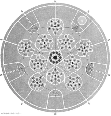
city—prepared jointly by Abdol-Aziz Farmanfarmaian Association of Tehran and Victor Gruen Associates of Los Angeles—defined and planned the site as an urban center. In the Gruen-Farmanfarmaian master plan for Tehran, Abbasabad was the center of one of the ten proposed “urban towns,” proposed to be tied by an extensive network of highways and rapid transit routes. Planned to house a modern neighborhood, the hilly part of the site was intended to become “a symbol of modern urbanism.” But the government had higher expectations, far beyond the bureaucratic design and limited scope of the master plan; in 1973, Louis Kahn was solicited, in association with the Japanese architect Kenzo Tange, to prepare a proposal for the new city center. Kahn’s design, however, remained at the level of preliminary sketches with his death in March 1974. In the same year, a development corporation was established by the municipality of Tehran to plan and build the urban center. In the final scheme of Llewelyn-Davies International (1974-76), the physical and functional scope of the complex expanded drastically, covering the hilly part of the site with a building program of more than five million meters of floor space.
This work aims to critically analyze the socio-political underpinnings of the three plans prepared for a new urban center in Tehran: the Gruen-Farmanfarmaian Master Plan (1966-70), Louis Kahn’s unfinished scheme (1973-74) and the final plan, known as Shahestan Pahlavi, prepared by Llewelyn-Davies International (1974-76). My attempt is to understand the ways in which international design currents, as embodied in these proposals and their designers’ approaches, meshed with the political, social and intellectual context of Iran in the last fifteen years of the Pahlavi reign, a period characterized by authoritarian rule, rapid modernization and fervent nationalism.
The conceptual framework of this study is derived from the three main roles of the proposed new urban center: civic, national, and international. I will interpret these three proposals at these three interrelated levels; as instances of thinking about a civic center and metaphors of urban life; as political tools of nation building in the
15
postwar web of nation-states; and as products of international design currents. The interconnected matrix of these levels allows for a fuller understanding of the multiplicity of voices and complexity of the modernist project.
Civic. In order to understand the civic scope of the projects, I examine them within their immediate urban context as well as in the broader metropolitan area. Geographically, the site of Tehran’s new urban center was not at the center of the whole city but rather at the center of its northern part—the urban locus of an emerging upper middle class. Images of modernity (highways, residential towers, shopping centers, and theaters), were all targeted toward this specific social group.
National. In the proposals for Tehran’s new urban center, one discerns a political will to create a modernized, acculturated and apolitical middle class. This social agenda was interwoven with a nationalism promoted through monarchy—the king and the queen—portrayed, paradoxically, as a deeply historical yet modern institution.
International. As works of international modernism, the trajectory of these projects span a shifting period in the international architectural discourse: the story begins with a modernist master plan—idealistic and devoid of notions of history (Gruen); it then moves to the work of an idiosyncratic intuitive architect of late modernism (Kahn); it concludes with an “urban design” project that negates modernist ideals of free rational planning in favor of spatial uniformity, axial configuration and historical urban forms (Llewelyn-Davies). By analyzing this trajectory, this work provides a case study of how with the postwar internationalization of modernism, its social premises—as attempts to make sense of industrialized societies—metamorphosed into development agendas in service of oil-rich autocratic states.
While the shift from Gruen to Llewelyn-Davies is emblematic of this larger global transformation, Kahn offers a unique alternative voice in late modernism. In this thesis, I demonstrate how Kahn’s idiosyncratic
16
perceptions intersected with the growing interest in traditional architecture and the idea of Eastern spirituality in Iran. The shift from Kahn to Llewelyn-Davies shows how the intuitive approach—as signifier of an alternative yet problematic modernity—was crushed under the heavy demands for rapid modernization, fueled by the idea of “catching up with the West” made possible by soaring oil revenues.
Ultimately, the story of Abbasabad is the story of a modern metropolis. As a visionary future was being imagined for Tehran and its new urban center, the city was expanding rapidly, not merely in the direction that the urban plans had projected. It was this conflation of planned and spontaneous urbanization that brought larger portions of the society into direct contact with modernity, modernization, and their inherent tensions. The result was a city whose spatial form—and ultimately its fate—was shaped by the combined effects of everyday interactions of ordinary people with modernity, on the one hand, and top-down modernization on the other.
Except for a short essay by Bernard Hourcade, the proposed projects for the Tehran new urban center have not been the subject of scholarly attention.3 Similarly, there have been very few studies on the planning ideas that have shaped modern Tehran. My investigation, however, benefits greatly from the emerging scholarship on modernism in the Middle East as well as the new critical studies of the architectural history of contemporary Iran.4 By focusing on the large-scale urban planning projects, I attempt to shed light on other less-studied aspects of the modernist project in the final decade of the Pahlavi reign. Building a new urban center for Tehran was the most ambitious project of the Pahlavi era, and hence it occupies an important place in the national and social agenda of the state and its manifestations in architecture and planning discourses.
4. My work particularly benefits from the scholarly works of Talinn Grigor, who has worked extensively on modernism, nationalism and architecture in Iran. This research provides further evidence for many of her interpretations. My attempt is to understand the interactions of broader trends with internal discourses. See Talinn Grigor,
Building Iran: modernism, architecture, and national heritage under the Pahlavi monarchs (New
York: Periscope Publishing, 2009). 3. Bernard Hourcade, “Urbanisme et Crise Urbaine Sous Mohammad-Reza Pahlavi,” in Téhéran: capitale
bicentenaire (Paris: Institut français
17
Method
In order to identify the ideological stances and implicit assumptions of the plans, my analysis begins with a close reading of texts, with particular attention the terminology and details of descriptions. While the consultancy reports constitute the main source for the analysis of the Gruen and Llewelyn-Davies proposals, I have used the office documents in Kahn’s archive for the contextual analysis of his project. The textual analysis is complemented with a detailed examination of architectural representations. I have interpreted models, drawings and renditions to delineate the plans’ paradoxes and underlying assumption, not merely as further proof for textual information.
I have also used archival documents and journals to establish the broader architectural context. Demographic and physical changes are studied through maps, aerial photos, photographs, and census information, largely provided by consultancy reports. Historical studies of Mark J. Gasiorowski, Homa Katouzian and Ervand Abrahamian are the main sources for the political, social and economic history of modern Iran in the 60s and 70s.5
Thesis Structure
Narrated through historical progression, the thesis is divided into three main chapters, each focusing on one project. Chapter one begins with a brief description of the historical geography of Tehran from 1930 through 1965, when the preparation of the city’s first master plan was begun. By presenting this historical preview, the first part of the chapter situates Tehran of the mid-1960s in its urban and political context. The chapter then examines the Tehran Comprehensive Plan and its proposal for Abbasabad. Despite its reliance on scientific analysis, the ultimate goal of the Gruen-Farmanfarmaian plan, I argue, was to create an image of a modern city, and to promote a lifestyle that would be on par with its contemporaneous Western (American) cities.
5. Ervand Abrahamian, A history of
modern Iran (Cambridge: Cambridge University Press, 2008) and Iran between two revolutions (New Jersey: Princeton University Press, 1982).
18
Chapter two focuses on the short yet unexplored involvement of Louis Kahn in the Abbasabad project. In addition to the materials in Kahn’s archive at the University of Pennsylvania, I have used architectural journals to establish the context of Kahn’s design for Abbasabad. The first part of the chapter focuses on Kahn’s engagement with a symposium on “the Interaction of Tradition and Technology,” held in the Iranian city of Isfahan in 1970. I show how Kahn’s intuitive approach became intertwined with cultural essentialism.
Chapter three focuses on the Shahestan Pahlavi plan, prepared by Llewelyn-Davies International, under the leadership of the American planner Jacquelin Robertson. As a large urban scheme, this plan exemplifies the shift that occurred in the planning discourse from modernism to a new paradigm that puts more emphasis on image, identity, and perception of urban spaces. As a national symbol, Shahestan, I contend, is the manifestation par excellence of what Muhammad Reza Shah, relying on soaring oil revenues, envisioned to project as the image of a modernized, yet historical nation-state. In this chapter, I will show how the increasing oil revenues impacted its design and how certain historical narratives formed the plan’s frivolous attempts to incorporate traditional architecture.
In conclusion, I assess the plans by situating them in the broader context of architectural production in the 1970s. Ultimately, the trajectory of the Abbasabad plans demonstrates how the demand for rapid modernization obliterated alternative voices and eventually led to “the tragedy of development.”
19
Chapter One
21
I. Gruen and Farmanfarmaian
The Abbasabad site was first defined and planned in the late 1960s in the Tehran Comprehensive Plan (TCP), the first master plan of the city prepared jointly by Victor Gruen Associates of Los Angeles and Abdol-Aziz Farmanfarmaian Associates of Tehran. The TCP envisioned a metropolis with ten urban districts, containing 5.5 million people, connected by an extensive network of highways and organized around ten commercial cores tied by rapid transit routes. The preparation of this idealistic master plan took place thirty-five years after the demolition of Tehran’s nineteenth-century walls: a turning point in the history of the city which opened the way for its postwar dramatic expansion. Before examining the overall master plan and its proposal for Abbasabad, this chapter gives a brief account of the historical geography of modern Tehran from the demolition of its fortifications in the early 1930s until the preparation of its first master plan in the mid-1960s.
Historical Geography of Modern Tehran (1930-1965)
Until the late nineteenth century, Tehran was a small town, famous for its gardens, pomegranates and aged plane trees. The early history of the city was overshadowed by the presence of the city of Rey, an important urban center of the medieval Muslim world, which was devastated during the Mongol conquests of the thirteenth century C.E. Located on the northern fringe of the central Iranian plateau, Tehran occupied less than four square-kilometers and had the familiar structure of the historical cities of the region: a linear bazaar connected the southern gate to a roughly rectangular citadel, which was surrounded by five neighborhoods (mahalleh) containing a dense fabric of narrow winding alleyways and courtyard houses. Tehran became the capital in 1789 by the order of Aga Muhammad Khan, the founder of the Qajar dynasty (1772-1925), who chose Tehran as the capital; but the original walls of the city—built by the order of Safavid Shah Tahmasb (reg. 1525-76) in 1553 C.E.— remained intact for a century, until the late nineteenth century, when,
22
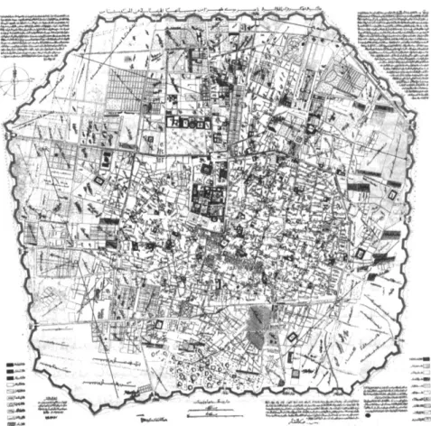
under Naser al-din Shah (reg. 1848-96), the city was enlarged and surrounded by octagonal walls modeled after Vauban’s design for Paris (Fig. 1).1
The story of modern Tehran begins with the demolition of the Nasseri walls and gates. Despite the undertakings of the late Qajar period, Tehran had remained largely traditional in urban form and architecture, exhibiting a touch of eclecticism—combining motifs and elements of European classical architecture with those of traditional Islamic architecture—particularly in its northern European-elite-inhabited neighborhoods. It was in the 1930s, under the autocratic state of Reza Shah Pahlavi (reign 1925-41), that a sequence of interventions transformed the city from a walled town into a modern-looking city with a super-imposed network of broad streets—a process generally compared to the transformation of Paris by Haussmann in the mid-nineteenth century. The urban transformation was swift and radical; over the course of a few years, all the gates and walls were torn down, broad avenues Figure 1. The 1891 map of Tehran.
By building the new moat and walls in a distance of two kilometers to the north and one and a half kilometers to the other three directions, the area of the city grew from almost four to twenty square kilometers. The old city and citadel are visible in the center of the map. Instead of the old six gates, the city acquired twelve gates. (Later, with the construction of the railroad, another gate was added.) Growing to the north, many gardens and palaces of the notables were added to the city which turned into the upper class neighborhood where European and the elite lived. As the map shows, many parts of the city were not built upon covered by gardens or farm lands for later developments. This map of Tehran was prepared by Abd ol-Ghafar Khan and his students. Source: H. Bahrambeygui
Tehran: an Urban Analysis
(Tehran: Sahab, 1977), 24.
1. The design of the octagonal walls is attributed to General Bohler, a French instructor of Dar ol-Funun, a polytechnic institute established in 1851 by the order of Amir Kabir (1807-1852), the powerful vizier of Nasser al-din Shah. For a study of this plan and Tehran in the late nineteenth-century see Mahvash Alemi, "The 1891 Map or Tehran: Two cities, two cores, two cultures."
Environmental Design: Journal of the Islamic Environmental Design Research Centre 1 (1985): 74-84.
23
were built on the moats, and cross-shaped streets (khiyabans) cut through the dense fabric of the city center.2 Even a large portion of the old core was razed to the ground to make way for the construction of a stoke market (bourse).3 Within the city, “street widening” was the key word of urban projects—justified as a necessity for motor vehicles; the underlying motivation of the urban projects, however, was to create an image of a modern city: a report on one the first street-widening projects, published in the Tehran Municipality’s Magazine (Majalleye Baladiyye) in 1927, stated how after the implementation of the project “the bad-looking tiny shops running along the street have been replaced by superb stores.”4
Urban projects had less to do with the functional aspects of the city than with its appearance—its modern representation.
The urban transformation of Tehran was an integral part of the reforms promoted by the state of Reza Shah, which aimed at creating a homogenous, secular and modern nation-state out of the multi-ethnic territories that it had inherited from the Qajar dynasty. It was along the same lines that a dress code outlawed the traditional dress (chador) for women and made a cylindrical hat (kolah Pahlavi) mandatory for all men.5 Even the performance of the ritual of Ashuara, the most important Shiite ceremony, became forbidden. In the same period, a secular judiciary and a modern educational system replaced the religious courts and schools (madrasas) traditionally administrated by the clergy. Bureaucracy, court patronage and a modern military were the three main pillars of “New Iran.”6
It appears that most of the interventions in Tehran were based on an idealistic plan prepared in the early 1930s, which proposed a network of boulevards and a relatively rigid system of zoning mostly inspired by the principles of the Modern Movement.7 Straight streets, monumental roundabouts at intersections, and a checkerboard pattern for residential areas were the key concepts of the plan that were implemented in the 1930s. The streets that were built on the moats opened the way for the expansion of the city toward west and north.
2. The term khiyaban originally referred to orthogonal pathways of gardens, but since the 16th century it also designated a monumental tree-lined avenue outside the city. The modern meaning of the term emerged with these projects.
3. Sangelach was one of the five neighborhoods (mahallas) of Tehran. The ambitious plan to build a stoke market was never realized. In 1950s, however, the vacant land was turned into the first large urban park of Tehran known as Park-e Shahr. Seyyed Mohsen Habbi, Az Shar ta Dhahr [de la Cite a la ville] (Tehran: Tehran University Press, 2003) 128.
4. “Khiyaban-i Cheragh Bargh,” in Majalleye Baladie, issue 4, 1927 [1306]: 21-24. Archives of the library of the University of Tehran.
5. Homa Katouzian, State and
Society in Iran: The Eclipse of the Qajars and the Rise of the Pahlavis
(London: I.B.Tauris &Co Ltd, 2000) 335-6
6. Ervand Abrahamian, Iran
between two revolutions
(Princeton: Princeton University Press, 1982), 38.
7. Unfortunately there are very few archival studies on the ideas and plans that formed Tehran in the interwar period. The map referred to here is kept in an office of the municipality of Tehran, but has not been studied.
24
Twomajor architectural styles became dominant in the new streets of the capital, replacing the eclectic style of the late Qajar period: a modern abstract style inspired, in part, by the neo-classicism of interwar Germany, and a historicist style that used pre-Islamic architectural motifs on the exterior. While the former was generally used in the multi-story concrete buildings that lined the new streets, the latter was employed in governmental structures. Through the railroad network and its stations, the hegemonic visual identity of the state was disseminated throughout the country. The years between 1930 and 1941 also saw the emergence of a new form of housing, characterized by orthogonal streets, particularly to the west and north of the city. These new neighborhoods were chiefly intended for employees of the government, karmandan. The expanding bureaucracy of the Pahlavi state translated into new residential areas.
Figure 2. The 1937 plan of Tehran,
which became known as Map of Streets (khiyabanha). On the plan, according to a note at the bottom of the sheet, “His Majesty, Reza Shah had marked with a red pen.” This reminds one of Haussmann’s Paris where “Napoleon III with his own hand, ‘his own august hand,’ plotted the alterations he intended to make in the city.” See Sigfried Giedion, Space, time and architecture (Cambridge: Harvard
University Press, 1967), 740. Image source: Tehran GIS Organization.
Figure 3. Photo showing the ruins
of Tehran’s walls and gates. Source: Hossein Kariman, Tehran
dar Gozashte va Hal (Tehran: Melli
25
In this process of urban transformation, the city center acquired a new meaning and signification. With the replacement of the imperial seat to the west of the city, most of the Qajar palaces were torn down to make way for modern buildings housing ministries and governmental institutions: The physical center of the city was no longer a closed space covered by interconnected gardens and courtyards used by the Shah’s harem, but rather an open imposing space dotted with free-standing modernist buildings, epitomizing the centralized state of Reza Shah and its heavy reliance on bureaucracy. The symbolic center of the nation that the state of Reza Shah was attempting to construct was not the locus of the institution of monarchy but secular judiciary, ministries, and modern banks.8
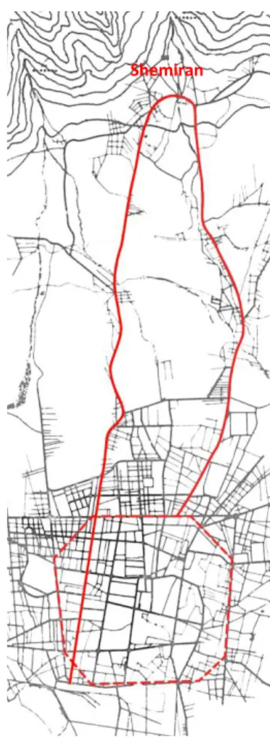
The northward expansion of the city began in the same period. The urban growth was targeted toward Shemiran: a foothill region stretching to the south of the Alborz Mountains, some five kilometers north of the old core of the city (Fig. 4). With small villages, verdant valleys and a milder weather, Shemiran was an appealing retreat from the hot summer days of Tehran since the nineteenth century. Qajar monarchs had built several summer palaces in the foothill region overlooking the city. The main road connecting the city to Shemiran was Old Shemiran Road, which terminated in Tajrish, the central village of the foothills. In the 1930s, the north-south connection was augmented by the construction of a new tree-lined street (Pahlavi Road)—running parallel to the east of the Old Road—linking the railroad station to a new palatial complex in Shemiran, called Saadabad. It was along these two avenues that the postwar expansion of the city took place.
In the summer of 1941, when Soviet and British troops entered Tehran and the Allied forced Reza Shah to abdicate, little remained of what defined the Capital of Naser al-din Shah Qajar (Dar ol-Khalafeye Nasseri). To Western visitors, the city looked quite modern, though behind the modern façade of the new broad streets, narrow winding alleyways—and their concomitant social structures—continued to exist (Fig. 5).9
8. Initially Reza Khan, who assumed power through a coup d’état in 1920, aimed to establish a republic, inspired by the reforms led by Ataturk in Turkey. The idea was rejected, particularly by the clergy. See Abrahamian, Iran
between two revolutions.
9. See for example the reflection of the director of the Point Four Program, who was shocked by the modernity of Tehran at the first glance and then realized the hidden part of the city. See William E. Warne, Mission for Peace (New York: Bobbs-Merrill, 1956).
Figure 4. Map of Tehran, showing
the northward growth toward Shemiran along Old Road (right) and Pahlavi Road.
26
The two decades that followed the end of the Second World War were characterized by the proliferation of neighborhoods outside the city, sponsored by both private and public sectors. At first, the lands possessed by the aristocrat families were subdivided and sold. Soon after, in reaction to the emerging lucrative market over the peripheral vacant lands, the government also initiated a housing program. The legal framework for public housing was provided in 1951, when the government became the owner of the unused lands (zaminhaye mavat) surrounding the city. The fragmented development was the result of the lower prices at a distance from the city.10 These suburban neighborhoods were composed of straight streets lined with rectangular plots, oriented in north-south direction to maximize the solar gain. The only feature that distinguished the designed neighborhoods from those developed by the private sector was the provision of public green spaces in the former. On Figure 5. Map of Tehran in the
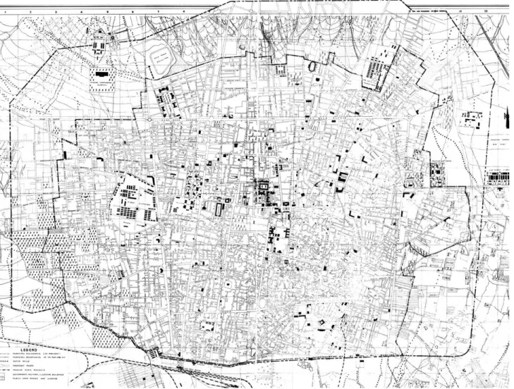
early 1950s. Buildings with solid black hatch are by-and-large additions of the Reza Shah period, which shows the concentration of governmental buildings at the center of the city. The dashed lines represent the exiting and proposed boundaries of the city for the 1980, which proved too optimistic for the rapid urbanization of the following decades. Source: H. Bahrambeygui,
Tehran: an Urban Analysis, 44.
10. The twentieth century urban planning experience, Robert Freestone (Ed.). (Sydney: University of New South Wales, 1998), 104.
27
the other hand, modernist aesthetics turned into the dominant language of architectural design, particularly in the areas located to the north of the old core, where mid-rise apartment buildings were gradually emerging. Western-educated architects played a key role in the design of residential complexes and the dissemination of modernist vocabulary of solid forms and austere elevations.
The governmental modernization of the 50s and 60s, however, was largely concentrated on rural areas and provincial towns. As manifested in the Truman’s Point Four program,11
this preference was informed by the U.S. Cold War policy that favored reforms in the areas with potential threat of espousing communism. The propagandist apogee of these efforts took place in 1962, when Muhammad Reza Shah ushered the White Revolution: an extensive land reform plan accompanied by programs for modernization of agriculture, education, sanitation, etc. The Shah’s Revolution was a modernization package in tune with the development theories prevalent in the 1950s and 60s, which called for total restructuring of the “underdeveloped” societies of Asia, Africa and South America.12 The land reforms had a serious bearing on Tehran, though: many peasants, no longer capable of effective production in their allocated lands, began leaving villages for the vocational opportunities that the capital had to offer, which resulted in a rapid growth in Tehran’s population.
By the early 1960s, as a result of these social transformations, a clear north-south polarity had taken shape in the city: while well-to-do families had begun residing permanently in their villas in Shemiran, immigrants were gradually settling the old urban fabric of the city center and the emerging shantytowns of its southern periphery. In 1967, the Shah’s family left the Marmar Palace of the old core for the Niavaran Palace in Shemiran. 13 In the mid-sixties, in terms of social and physical structure, Tehran could be divided into three main regions: the old core, the central and the north, inhabited by low-income, middle-income and high-income groups, respectively.14 The hierarchical distribution of these regions corresponded with the topography of the city: the northern part,
11. William E. Warne, Mission for
Peace, Point 4 in Iran (New
York: Bobbs-Merrill, 1956).
12. See Arturo Escobar,
Encountering Development: The Making and Unmaking of The Third World (New Jersey: Princeton
University press, 1995), 4.
13. Designed by the Iranian architect Mohsen Foroughi, the new Niavaran Palace, initially intended for ceremonies, was built between 1956-67 in a garden of Qajar era, where a nineteenth century summer palace was already standing. It became the permanent residence of Muhammad Reza Shah’s family in 1967.
14. Victor Gruen Associates and Abdol Aziz Farmanfarmaian Planners and Architects, The
Comprehensive Plan for Tehran, First Stage: Concept Development,
28
which has a relatively milder weather in the summer, had larger plots and was inhabited by wealthy families and high-ranking officials of the government; low-income classes lived in the southern part; and the central areas were occupied by middle-income families in two distinct patterns: low density residential units to the east and west, and three-to-four-story apartment buildings in the northern part, between the old core and Shemiran.15
The early 1960s also marked the last presence of urban protesters on the streets of Tehran until the revolution of 1978-79. With the suppression of the 1963 uprising (15 Khordad Revolt), which put an end to the minimal activities of the opposition groups after the coup d’état of 1953, began a period of political stability and oppressive rule that was to last for fifteen years. Relying on a notorious secret police (SAVAK), increasing oil revenues and U.S. military and economic support, in 1963 a highly autonomous state had been realized.16 By 1966, when the consortium of Gruen and Farmanfarmaian began to prepare a 25-year plan for Tehran, its population had reached 3 million (which was 700,000 at the time of demolition of the walls), with 180 square-kilometers of built area (including Rey and Shemiran).
Figure 6. Map of Tehran in the mid
1960, showing the development of the city when Gruen-Farmanfarmaian began the plan. The fragmented development of the areas around the city was a reflection of the lower prices of the peripheral lands (in eastern and western parts) and an increased reliance on private vehicles (in northern neighborhoods).
Source: TCP 15.Ibid.
16. Mark J. Gasiorowski, U.S. Foreign
Policy and The Shah (Ithaca: Cornell
29
The Comprehensive Plan for Tehran: Importing an American
Dream
[T]he habit of the people of the United States of America is that women usually take their husbands to work, then drop off their children at schools, and go shopping on their way home. The same trend is gradually becoming evident in Tehran, and the degree of its success at the end of the plan depends on the efficiency of the public transportation network. Yet, in terms of planning, the use of private vehicles should be the basis of future developments.
—The Tehran Comprehensive Plan, 1968.
In late 1965, the Plan and Budget Organization of Iran approached the architect Abdol-Aziz Farmanfarmaian to prepare a 25-year growth plan for Tehran.17 In the same year, High Council for City Planning had been created by the Organization to oversee the preparation of master plans for major cities. The commission, however, was contingent upon collaboration with a “foreign partner.” In an interview in 2006, Farmanfarmaian recalled that the choice of Victor Gruen Associates as the foreign partner was quite fortuitous: the link between the American and Iranian firms was Fereydoon Ghaffari, an Iranian town planner employed by Gruen Associates, who was in Tehran at that time looking for a potential project for Gruen’s firm. The following year, Gruen travelled to Tehran and a contract was signed first between the partners and in February 1966 (Bahman 1344) with the government.18
In Iran, theoretical foundations for a modernist approach to large-scale planning had been shaped in a conference, Seminar on Social Problems of Tehran, held at the University of Tehran in 1961. It was in this symposium that a translation of the Athens Charter, the canonical manifesto of modernist urban planning, was presented to Iranian audience for the first time. The participants in the conference—largely Iranian architects and high-ranking officials but also foreign advisors of
17.Established in 1947 to promote economic development programs, the Plan and Budget Organization was administrated by apolitical technocrats who became the dominant group in the government after the suppression of opposition groups and consolidation of the state in the early 1960s. The main task of the organization was to prepare development plans, which began in 1949 with the assistance of American advisors. The preparation of the master plans was part of the Third Development Plan (1963-67).
18. “Interview with Abdol-Aziz Farman-Farmaian,” Shahrnegar, Journal of Urban Planning and GIS, No.36, Aug. 2006, 18-25.
30
Tehran’s municipality—called for total redevelopment of the old core of the city and the provision of a master plan for the capital.19
For the task of preparing a master plan for Tehran, Farmanfarmaian architectural firm was the best, and perhaps the only, Iranian choice for the government. Scion of a Qajar aristocratic family and a graduate of the Ecole de Beaux Arts, Abdol-Aziz Farmanfarmaian (b. 1920) had established the first “consultant architects firm” in the country and was a prolific architect, designing several modern houses, as well as high-rise corporate buildings since his return from Paris in 1950. The Comprehensive Plan for Tehran was, however, the first “urban venture” of Farmanfarmaian Associates.
The Austrian-American architect and planner, Victor Gruen (1903- 1980) spent 30 years of his life in the United States, where he became known as the mastermind of shopping malls, described as the designer who gave architectural shape to American consumerism.20 Born in Vienna in a Jewish family, his career in the U.S. began in the early 1940s, subsequent to the Nazi occupation of Vienna. By the early 1960s, the focus of his work had shifted from mall design to urban planning. In his 1964 book, The Heart of Our Cities, Gruen proposed an ideal diagram for a metropolitan region, a proposal that closely resembled Ebenezer Howard’s Garden City (Fig. 7).21
His role in the master plan of Tehran, however, appears to have been limited to the first stages, as he retired from Gruen Associates in 1968, in part because of his ailing health, but largely to fulfill his lifetime desire of returning to Vienna.22 Fereydoon Ghaffari was the principle designer that played the key role for Gruen Associates in the master plan of Tehran.
19. Seminar on the Social Problems
of Tehran (Tehran: University of
Tehran, 1961).
20. For a detailed study of Gruen’s American career see M. Jeffrey Hardwick, Mall Maker: Victor
Gruen, Architect of an American Dream (Philadelphia: University of
Pennsylvania Press, 2004)
21. In the book, Gruen states that it was after completing his diagrams that he realized someone else had proposed a similar diagram. See Victor Gruen, The
Heart of Our Cities (New York:
Simon and Schuster, 1963) 22.Hardwick, Mall Maker: Victor
Gruen, Architect of an American Dream.
31
The Tehran Comprehensive Plan (TCP) was prepared in two stages. The final consultancy report was drafted in English and a translation with minor modifications was submitted to the government. The first stage, “Concept Development,” consisted of five volumes with over 1500 pages. While the first volume provides a summary of the whole report, the second and third volumes shape the main body of the report. The second volume, “Study and Evaluation,” is basically a detailed study of Tehran, its history, current status and future needs, providing an extensive physical program for the plan. Concluding with “Projection of Growth,” it leads to the third and the core of the report, “The Planning Concept,” where the main ideas of planning and growth are presented. Organized in a classical urban planning report, the third volume begins with goals and objectives, followed by a planning program. It then offers a number of alternative patterns and subsequently presents the concept for the comprehensive plan and its economic aspects. The relatively brief
Figure 7. Gruen’s diagram for “the
cellular metropolis” of tomorrow: “ten cities surrounding metro core consisting of ten core frame units and metro center. Source: Victor Gruen, The Heart of Our Cities (New York: Simon and Schuster, 1963), 272.
32
fourth and fifth volumes, “Recommendations for Urgent Problems” and “Appendix” are complementary to the main text and target the current problems which need to be addressed in short term. A full examination of the Tehran Comprehensive Plan is beyond the scope of this study. A review of some of its key features, however, will help situate the proposals for Abbasabad in their broader context, and is essential to understanding the site’s future transformations as well as the transitions in the architectural culture of Iran in the following decade.
The plan enumerates the major problems of the city as high density (especially in the city center), air pollution, inadequate services, unemployment, and constant migration.23 The document also alludes to a shortage in housing: while there are 20,000 extra residential units for the high-income portion, at the level of low-income classes a shortage of 80,000 residential units is discernable. In terms of economic prospect, the most significant trend in the next 25 years would be a considerable increase in income per capita and car ownership.24
The TCP is also preoccupied with the image of Tehran as a capital. A survey of Iranian historical capitals (such as Shiraz and Isfahan) and modernist cities like Brasilia and Chandigarh was carried out to determine the elements that constitute “a recognizable and admirable capital image.” Based on this study, the document concludes that, “Tehran has neither the historical characteristics of Rome and London, nor the controlled appearance of Washington or Canberra.”25
In keeping with the modernist emphasis on rationalism and scientific analysis, the TCP attempts to base its proposal on extensive social, economic and demographic studies. Part of these studies, conducted by the Institute for Social Studies, showed that the population of Tehran at the final stage of the plan in 25 years would reach between 12 to 16 million. However, the officials—and probably the Shah himself— decided to limit the population to 5.5 million, allegedly due to the limited water resources.26 This decision required a decrease in the rate of
23. Gruen and Farmanfarmaian,
Comprehensive Plan for Tehran, Stage I, Concept Development,
Volume I, 5-9.
24. Ibid., C-I-52.
25. Ibid.
33
population growth from 5.2% to 1%. It appeared as if a royal decree would determine the future.
In order to determine the most appropriate “development concept” for Tehran, the TCP uses oversimplified abstract notions of urban form, developed in utopian proposals since the nineteenth century. The final proposal is an east-west linear growth, a concept privileged over nuclear and distributed “forms of growth” on the basis of a brief analysis of advantages and disadvantages of each type:
The negative aspect of the nuclear type of growth is that the city center gains excessive importance, which would result in an undesirable high density, congestion and decreased accessibility of the city center. On the other hand, the second type, a distributed fabric with multiple centers, is not suitable for Tehran’s climatic conditions and its implementation would require strict regulations. Hence, a linear growth, in which centrality is minimized, has fewer negative impacts.27
Unpleasant climatic condition in the southern periphery of the city and the presence of eastern and northern mountain ranges are the main factors determining the east-west direction of urban growth. The metropolis of 1991 would consist of ten districts, each with 0.5 million population, separated by the green valleys descending from the Alborz Mountains. While the north-south connection is emphasized, a large green area is proposed to separate the southern town of Rey, and to
27. Ibid, III-3-8
Figure 8. (above) Forms of growth,
that were presented as alternatives to a linear growth. Source: TCP
Figure 9. (left)The development
concepts of Tehran. As Madanipour has pointed out the master plan for Tehran can be considered as a linear version of Gruen’s ideal metropolis. Source: TCP
34
enhance the linear growth of the city. Each district would contain a commercial and an industrial center.
For transportation, the TCP proposes a “complete network of highways” with the total length of 150 kilometers. Yet the plan also attempts to put a similar emphasis on a public transit system. Following a description of two different methods of transportation—network of highways and public transportation—the TCP suggests “a balanced system” as the best solution for Tehran’s transportation system. Referring to current transportation systems in Los Angeles as an example for network of highways and New York, Moscow, London and Paris as cities with extensive networks of public transportations (including subway trains and buses), the TCP suggests a balanced system of transportation like that of Chicago, claiming that such a system would combine the advantages of both systems. In the TCP’s final proposal for Tehran’s transportation, an east-west rapid transit route, with a branch heading to the south, is completed with two main east-west highways on the two sides of the rapid transportation route, giving access to all parts of the city (Fig. 9).
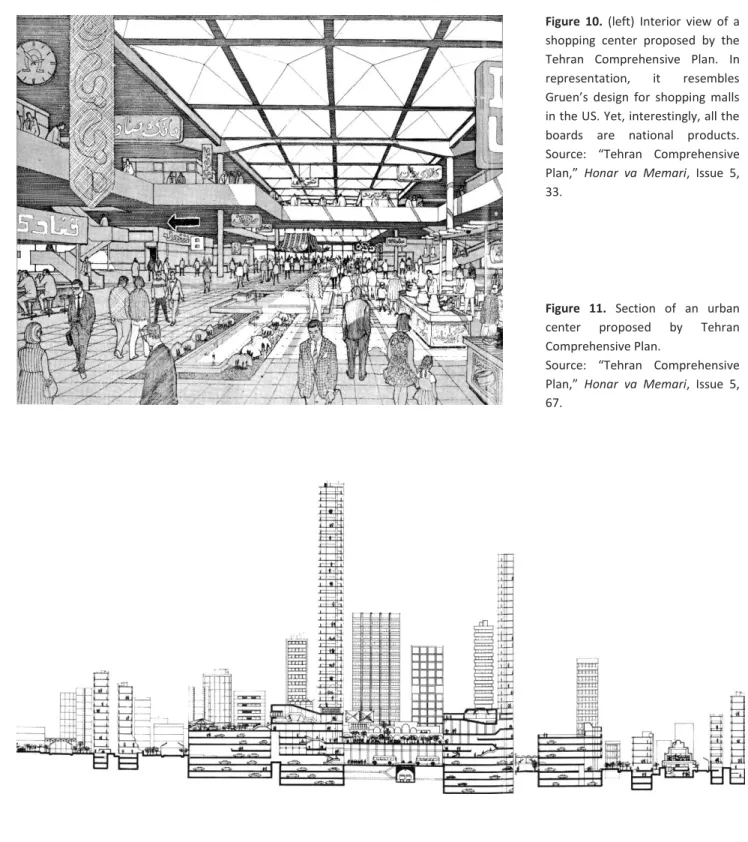
As Madanipour has also pointed out,the master plan of Tehran can be considered as a linear version of Gruen’s diagram for an ideal metropolis: 28 both plans consist of ten smaller units, the urban centers are connected by public transit lines, and large green areas separate the districts. The design of the urban centers also resembles Gruen’s designs for shopping malls and renovation plans for city centers in the United States (Fig. 10 & 11). Yet, the idea of a linear city is somehow at odds with Gruen’s idea of a distributed metropolis. In many ways, the TCP diagrams evince more similarities with Le Corbusier’s design for Chandigarh, whose green strips might have been the “formal” model for the green valleys of Tehran, displaying a formalism that was criticized by Gruen in The Heart of Our Cities. As it was with “high modernism,” Tehran was conceived like a tableau— an esthetic composition of green strips, parkways and highways.
28. Ali Madanipour, Tehran: the
Making of a Metropolis
(Chichester: John Wiley, 1998), 208.
35
Figure 10. (left) Interior view of a
shopping center proposed by the Tehran Comprehensive Plan. In representation, it resembles Gruen’s design for shopping malls in the US. Yet, interestingly, all the boards are national products. Source: “Tehran Comprehensive Plan,” Honar va Memari, Issue 5, 33.
Figure 11. Section of an urban
center proposed by Tehran Comprehensive Plan.
Source: “Tehran Comprehensive Plan,” Honar va Memari, Issue 5, 67.
36
The Social Structure of the Metropolis
In terms of social structure, the TCP extends the newly formed north-south social division of the existing city to the areas planned for development to the west: just as in the existing city, well-to-do families would “naturally” settle the northern foothill region; the southern parts, which are closer to industrial centers, would be inhabited by low-income people; and the central areas are reserved for middle-income group. The middle class is referred to as the least satisfied class in the city as they have the desire to enjoy the same life-style of the wealthier for which they do not have the financial resources. The plan, therefore, strives to provide the facilities of a “modern life-style” to satisfy the developing middle-class. 29
The underlying social vision of the TCP is particularly evident in the plans and descriptions that it offers as prototypes for different income groups. Modeled after the concept of “Neighborhood Unit,”30 the typical high-income neighborhood is composed of large plots arranged around an open space with an elementary school (Fig. 13). Accessed by highways and curved roads, the neighborhood is mostly covered with single-family plots; though luxurious apartment buildings with “swimming pools and tennis courts” are also provided, perhaps to enhance the modern image of the neighborhood. Because of their high income, the document further relates, “automobile, television, refrigerator, garden and skiing” would be important in the lives of these families.31 (The first three commodities clearly indicate the consumerism that was being promoted by the master plan.) It appears that this was the group for whom the entire city was being designed, whose life-style would attract other income groups: with their “increased mobility,” the middle-income families “will tend to settle in the northern parts of the city.”32
In contrast to the curvilinear street system of high-income districts, the typical southern neighborhood is composed of orthogonal grid with tiny plots, probably modeled after the Doxiadis grid design (Fig. 14).
30. According to Clarence Perry’s diagrammatic planning model for neighborhoods, the city should provide services in different scales. The basic unit of a neighborhood is associated with the number of households in a walking distance to an elementary school. A combination of these units shape a larger unit serviced by a high school and etc.
31. “Tehran Comprehensive Plan,”
Honar va Memari, Issue No. 5, 53.
32. The assumption of designing neighborhoods as transition was a common concept in postwar international modernism. The notion of social mobility was also present in the Doxiadis plan for Islamabad.
29. According to the TCP, the lower income groups “see Tehran as their Utopia, regardless of the deficiencies they face in the city.” like lack of clean water, high density and low standards of living.
37
Housing immigrants, the southern part is considered as a necessity, a transitory station for immigrants, who would be absorbed into the middle class in future. Although the idea of dividing the city in specific areas for certain income groups was not a new phenomenon in the master plan of Tehran, it had rarely been given such a clear spatial expression.
Figure 13 & 14. Plan of residential
neighborhoods for high-income (left) and low-income (right) communities.
Figure 12. View of the proposed
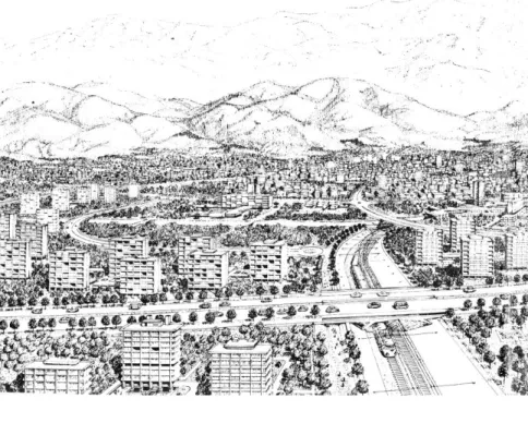
design for the northern part of the city. This vision was partly realized in the 70s. Source: “Tehran Comprehensive Plan,” Honar va
Memari, Issue 5 (The two other
images on this page are also from the same source)
38
The TCP Plan for Abbasabad Hills
The story of Abbasabad corresponds with the general historical geography of Tehran. Like many other lands located on the periphery of the city, Abbasabad initially belonged to Qajar aristocrat families. Old maps show that a structure was standing on the site, and that it was dotted by several strings of subterranean water channels (qanats). The land was purchased by the Agricultural Bank of Iran in the 1930s, and was later distributed among other governmental institutions, which then subdivided and allocated the plots to their employees. In 1963 (1342), the government approved repurchasing the land, which was completed in 1969.33 A map published in the TCP shows the whole area, similar to the surrounding fabric, was to be regularly subdivided (Fig.15). Thus, the idea of making Abbasabad an urban center existed before the preparation of the TCP.
In the general scheme of Gruen for Tehran, Abbasabad occupied a prominent position; it was not only the center of one of the ten proposed urban districts (mantaghe), but also located at the intersection of the two main axes of the city: a north-south axis, comprising four nodes — Shemiran, Abbasabad, the old city center and Rey—and the proposed Figure 16. Map of Tehran and its
environ in the nineteenth century, showing Abbasabad to the north of Tehran. Source: H. Bahrambeygui,
Tehran; an Urban Analysis, 22.
Figure 15. Plan for the subdivision
of Abbasabad prior to the preparation of the master plan of Gruen-Farmanfarmaian.
Source: TCP
33. “Planning System for Abbasabad,”
39
east-west axis along which the future growth of the city was envisioned. Moreover, the two main north-south and east-west public transit routes (metro) intersected on the southern part of the site.
The TCP divides Abbasabad into three parts: the Abbasabad district, an arbitrary boundary that encompassed one of the ten proposed districts of the master plan; the hills were reserved for housing development; and the Abbasabad urban center was located on the flatter lands to the south of the hills. The aim of the comprehensive plan for Abbasabad, then, was twofold: first, to prepare “an appropriate environment” for creation of “a modern urban center” (markaz-e modern-e shahri),34
and second, preparation of a plan for land subdivision, which would replace a pre-existing one (Fig. 15). The principal concern expressed is that the site might be filled with monotonous two-story residential buildings, which would be in contrast to making Abbasabad a sample of “modern urbanism” (shahrsazi-ye jadid), as envisioned in the master plan.
Figure 16. Urban districts proposed
by the Tehran Comprehensive Plan. Source: Llewelyn-Davies International, Shahestan Pahlavi (1976), Book I, 30.
34. Gruen and Farman-Farmaian,
Comprehensive Plan for Tehran, Stage I, Comprehensive plan for
40
Prepared as an attachment to the TCP, a report that deals with Abbasabad specifically is concise and follows the same visions of the overall master plan. Like the master plan, the urban analysis of Abbasabad district exhibits a heavy reliance on scientific methods: the need for new roads is based on a quantitative study of traffic flow in major thoroughfares. This scientific tenor gives the plan a seeming rationality, which is not necessarily related to the final design.
It is in the final parts that the true modernistic nature of the plans reveals itself—where hotels, stadiums, the green strips connecting the schools are described and “the beauty of highways” is emphasized. Judging by the descriptions of the neighborhood prototypes, the hilly part of the site was designed for high-income groups, although geographically it was not located in the northern part of the city: It was the altitude of a site that determines the appropriate social class that would inhabit it—the higher lands topographically were reserved for groups higher economically. In Figure 17. The Master plan’s
proposal for Abbasabad. Dots represent elementary schools, which are connected by green strips. Three district centers are also proposed. The southern part, in dark grey, is reserved for the urban center. Source: TCP
41
the TCP, Abbasabad was envisioned as a luxurious modern neighborhood, rather than an administrative center.
Conclusion
The Tehran Comprehensive Plan, and its proposal for Abbasabad, was a an instance of modernist planning, with similar grand aspirations, yet devoid of Early Modernism’s humanist premises and goals of social equality. It shows how with the postwar internationalization of modernism, it metamorphosed into a tool for development and creation of images of modernity.
Yet, ironically, the plan is devoid of explicit political manifestations or symbolic representations of state, a key feature of several postwar international urban plans. Unlike the Doxiadis master plan for Islamabad (1959), for example, no ceremonial axial space was proposed in the TCP; nor does the plan have the iconic center of, say, Brasilia, where the so-called Plaza of Three Powers was situated at the focal point of the crescent-shaped plan of the city. The study of the image of the capitals was hardly, if at all, reflected in the final master plan or its proposal for a city center at Abbasabad. (Even the consultancy report is devoid of the hyperbolic language of later projects praising the Shah and his glorious services to the country.) At the core of the master plan was the lifestyle of an economically prosperous capitalist society (read America), whose symbols—i.e., shopping malls, highways and privatized housing—were extrapolated to a new landscape: the plan was a replication par excellence of “American landscapes of consumption.”35 The culture of consumption was particularly celebrated by positioning the shopping malls at the foci of the ten proposed urban towns.
Of the four core urban functions proposed by CIAM (Congrès internationaux d'architecture moderne), the master plan’s emphasis was on housing and transportation rather than industry. Even the economic opportunities that the production of the city would create were to be channeled through the state: the entire infrastructure and large housing
35. Jeffrey W. Cody, Exporting
American Architecture, 1870-2000
42
developments were to be implemented through large public investment. In the oil-based economy of Iran, in which the government acted as the distributer of oil revenues, the modern city was to facilitate consumption rather than any real economic production.
Due to the master plan’s emphasis on material prosperity and the absence of direct ideological representation, scholars such as Ali Madanipour maintain that the Comprehensive Plan for Tehran—and generally urban planning in pre-revolutionary Iran—was largely an apolitical activity, a phenomenon that should be analyzed within a technocratic framework.36 Yet in the context of the 60’s, in which the democratic aspirations of modern middle class had been suppressed, this seemingly apolitical approach in fact served a highly political end: for the autocratic regime of the Shah, modern urban planning was a tool, a mechanism “to co-opt the modern middle class, the industrial working class, and other key societal groups, undermining support for opposition organizations among these groups.”37
What the TCP was attempting to create was a prosperous “apolitical” society whose main communal spaces, just as in its American model, were to be pseudo-democratic spaces of shopping centers.
Even so, from a post-colonial standpoint, the TCP should also be seen as a constituent part of the global experience of modernity and modernization. Despite the over-simplified statement of some studies, which regard non-Western societies as passive recipients of Western models, it was not the Shah “who chose Gruen for his Modernization program.”38
The preparation of the master plan of Tehran attests to the active role of the Iranian partner. In contrast to the common narratives, the non-Western agents of modernization and proponents of modernism in architecture and planning cannot be described as “brainwashed postcolonial elites,” who betrayed their ancestral tradition.39
In Iran, the genealogy of modernists can be traced back to the intelligentsia of the nineteenth century (the Qajar era), who, in the semi-colonial context of territorial losses to Russia and Britain, began advocating for extensive reforms and “the rule of law.” Like their Western counterparts, their faith
36. Ali Madanipour, Tehran: the
Making of a Metropolis
(Chichester: John Wiley, 1998), 206.
37. Gasiorowski, U.S. Foreign Policy
and The Shah, 187.
38. See for example the short account of Jeffrey Hardwick in Mall
Maker: Victor Gruen, 220.
39. William J. R. Curtis, Modern
Architecture since 1900 (Oxford:
43
in modernism stemmed from a deep belief in dramatic societal change, in a penchant for breaking with the past and replacing the old norms and institutions with something utterly new. From this perspective, the TCP presents a conscience appropriation of images of modernity.
Another noteworthy feature of the TCP is the absence of historical references or Orientalist fantasies, which were present in several postwar architectural and urban proposals in the Middle East. Walter Gropius’s design for the University of Baghdad (1953-58), for example, had engaged with several architectural and social aspects of the region.40 Similarly, Frank Lloyd Wright’s first reaction to a commission from the Iraqi government was excitement about designing in the land of A Thousand and One Nights.41 Even Doxiadis master plan for Baghdad (1958), attempted to incorporate some aspects of local culture by designating communal spaces of neighborhoods as gossip squares.42 It appears that the reason for the absence of Orientalist assumptions was the presence of an Iranian partner, with a firm belief in the global application of modernism. The absence of notions of history and local customs in the Tehran Comprehensive Plan is particularly important when compared with the proposals prepared for Abbasabad in the 1970s. The master plan of Tehran presents the first attempt to plan the Abbasabad site. While the hilly part of the site was designed to house a modern neighborhood, the southern flatter lands were reserved for the district’s urban center. The TCP’s proposal for Abbasabad was the basis for the projects that were prepared for the site in the 70s, including the proposals of Louis Kahn and Llewelyn-Davis International.
As a comprehensive plan, the TCP established the spatial and regulatory framework for the development of the city until the revolution of 1978-79. It is the main design proposal that has had the most significant impact on the physical form of Tehran. Beginning from the late 1980s, under the leadership of a new class of technocrats, the infrastructure of the Gruen plan was gradually implemented—an important part of a new modernization program begun after a decade of revolutionary instability
41. Panayiota I. Pyla, “Baghdad’s Urban Restructuring, 1958: Aesthetics and Politics of Nation Building,” Modernism and the
Middle East, 97-115.
42. Magnus T. Bernhardsson, “Visions of Iraq: Modernizing the Past in 1950s Baghdad,” in
Modernism and the Middle East,
88.
40. Gwendolyn Wright, “Global Architecture and Local Knowledge,” Modernism and the
Middle East: architecture and politics in the twentieth century.
Sandy Isenstadt and Kishwar Rizvi, ed. (Seattle: University of Washington Press, 2008), 221.