EXPLORATION
M
ETHODOLOGY,
COMPUTER PROGRAMS AND TWO CASESTUDIES IN THE
S
WISSM
OLASSEB
ASINThesis defended on January 8, 2015 at the
FACULTY OF SCIENCES
INSTITUTE OF HYDROGEOLOGY AND
GEOTHERMICS (CHYN)
UNIVERSITY OF NEUCHÂTEL
for the degree of
DOCTOR OF NATURAL SCIENCES
presented by
PIERRICK ALTWEGG
Accepted by the following Jury: PROF.PHILIPPE RENARD
PROF.STEPHEN ANDREW MILLER
PROF.GUILLAUME CAUMON
PROF.JON MOSAR
DR.EVA SCHILL
DR.FRANÇOIS-DAVID VUATAZ
To my beloved wife and children, Alexandrine, Elanor and Aurèle.
Acknowledgments
A PhD thesis is something unique in the life of a scientist but is not a project that one can carry alone. In this respect, many individuals, institutions and societies contributed to it and I want to gratefully thank them.
First, I owe much to Dr. François-David Vuataz who introduced me to the world of geothermal energy, saved me countless hours by being a living database and for her active participation in the project.
I also would like to thank Prof. Eva Schill who made this project possible. A special thanks to Prof. Philippe Renard who agreed to supervise this work after three years and for his availability and his advice. I also want to thank Prof. Daniel Hunkeler and Prof. Pierre Perrochet for their support.
My gratitude to all the members of the jury for their availability and their input after the critical review of this PhD thesis. I would like to especially thank Prof. Jon Mosar of the University of Fribourg for his time and input as well as for teaching me how to avoid formal errors in this work.
My acknowledgment to the following institutions and societies: to the Commission for Technology and Innovation (CTI) for the funding of the project, to the Sankt Galler Stadtwerke (SGSW) for the funding of the project and for the data of the Sankt Gallen Region, to RBR Geophysics the industrial partner of the project, to The BKW and Sol-E SA which provided data for the
Eclépens project and to the Karl Näf Stiftung which also contributed to the funding of the project.
My thanks to Pier-Vittorio Radogna of RBR Geophysics who believed in this project and followed it from the beginning. To Michael Sonderegger, Thomas Bloch and Marco Huwiler of the SGSW who helped me much for the Sankt Gallen project. To Pascal Vinard, Laurent Tacher and Robert Arn for their help concerning the Eclépens project.
A special thank you also to all the people who accepted to spend countless hours in the field doing gravity measurements: Laurent Marguet, Guillaume Mauri, Luca Guglielmetti, Gennaro Di Tommaso, Guillaume Gianni and Thommy Flament.
All my gratitude to Nicolas Clerc, Guillaume Mauri and François Negro for our endless discussions on the geology of the Swiss Molasse Basin and the Jura Mountains.
A special thanks to Christophe Ronus who designed the GInGER logo and agreed to correct my English.
Finally I would like to thank my family and all my friends for their support. I especially want to thank my wife Alexandrine for her unconditional support, understanding, help and encouragement during these five years.
Abstract
Keywords: Geothermal exploration, gravimetry, fault zone porosity
assessment, computer program, forward modeling, density inversion, Sankt Gallen geothermal project, Eclépens geothermal project.
In Switzerland and neighboring countries, most deep geothermal projects target deep aquifers associated with major fault zones. The objective of this thesis is to develop and test a methodology for the estimation and localization of such high porosity rock volumes in the underground using gravity data and 3D geological modeling.
To reach that aim, the computer program GInGER – GravImetry for Geothermal ExploRation - was developed. It allows to compute rapidly and efficiently the intensity of the gravity field in surface from 3D geological models. Then the user can compare the calculated response with measured gravity data and strip the effect of geological structures that are not relevant for the project. One of the main originality of GInGER is that it permits to directly assess the porosity of fault damage zones when providing their geometry. The software is also endowed with a graphical user interface and density inversion capabilities to be user friendly. In addition, for sensitivity analysis, an independent sister software named GInGERSP, based on the same principles allow to compute the gravity effects of simple geometrical shapes which can be superposed to a given geological model. This tool is particularly designed for rapid sensitivity analysis.
The two computer programs and the underlying methodology were tested on two ongoing geothermal projects in Switzerland, the projects of Sankt Gallen and Eclépens. Both projects are targeting deep aquifers associated with major faults zones affecting the Mesozoic sediments under the Swiss Molasse Basin. In both case studies, a preliminary step was to conduct a sensitivity analysis to determine the prerequisites allowing the assessment of faults damage zone porosity. This was done in 2D for the case study of Sankt Gallen and it appeared that, if the geometry of the fault zone is constrained enough, if the damage zone of the fault represent a sufficient volume and the error on gravity measurement is kept as small as possible, typically under 0.1 mGal. It should be possible to assess the porosity induced by the damage zone of the fault using gravity data and that even if the induced porosity is rather small, under 1-2 % if the affected volume is big enough.
In Sankt Gallen, the 3D geological model was established using 3D seismic data. Comparing the gravity effect of this model with gravity data specifically acquired, we were able to make a first estimation of fracture porosity that compared well with later measurements obtained from drilling. However, the presence of a Permo-Carboniferous graben in the vicinity of the fault zone prevents us from removing all ambiguities on the result.
In Eclépens, the 3D geological model was established using only 2D seismic data and oil exploration wells. As no accurate geometry of the different fault zones exist, it was not possible to assess precisely the porosity of the damage zones. However, using gravity measurements, acquired during this study, and the two computer programs, GInGER and GInGERSP, it was possible to make a sensitivity analysis, compare the possible effects of the various fault zones porosity and highlight the most suitable targets. This demonstrates how a user could use these two tools for any case study. Note also, that this work also revealed that a major Permo-Carboniferous graben of regional extent likely crosses the northern part of the model. This could, to a certain extent, explain the high geothermal gradient found in the Eclépens-1 oil prospection well which is located in the central part of the targeted area of the geothermal project.
For these two case studies, the application of the proposed methodology and the combined use of 3D modelling, gravity data, GInGER, and GInGERSP allowed to bring new and useful information for the geothermal projects.
Contents
Introduction ... 1
Motivation ... 3
Structure of the thesis ... 3
Fundamentals ... 7
Deep geothermal energy ... 9
2.1.1 Power production ... 11
2.1.2 Direct use ... 11
2.1.3 Deep geothermal energy in Switzerland ... 12
Geological setting ... 23
2.2.1 Hydrogeology ... 29
2.2.2 Geothermal condition under the SMB ... 33
Gravity exploration ... 35
2.3.1 History ... 35
2.3.2 Theory ... 38
2.3.3 Density ... 46
Methodology and tools ... 51
Introduction ... 53
Gravity data treatment ... 55
3.2.2 Regional – residual determination ... 64
Gravity modeling ... 65
3.3.1 Base principles ... 65
3.3.2 2D forward modeling ... 67
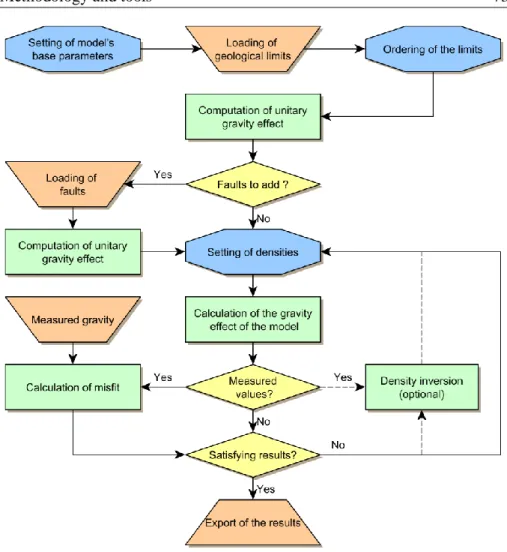
GInGER: GravImetry for Geothermal ExploRation ... 72
3.4.1 Geological model ... 74
3.4.2 Calculation of gravity effect ... 76
3.4.3 Faults management ... 78
3.4.4 Density inversion ... 91
3.4.5 Graphical User Interface ... 100
Simple shapes modeling: GInGERSP... 103
3.5.1 Simple shapes ... 104
3.5.2 Graphical User Interface ... 105
Case study: Sankt Gallen ... 107
Introduction ... 109
Geological setting ... 111
Synthetic case study... 116
4.3.1 Methodology ... 116
4.3.2 Effect of Quaternary deposits ... 117
4.3.3 Change of density of the geological formations ... 120
4.3.4 Depth and thickness of Mesozoic ... 122
4.3.5 Effect of a fault zone ... 125
4.3.6 Effect of a Permo-Carboniferous graben... 132
4.3.7 Conclusions ... 134
Geological 3D modeling ... 136
Gravity survey ... 141
4.5.1 Forward modeling and stripping ... 143
Results ... 146
Discussion ... 151
Case study: Eclépens ... 155
Introduction ... 157
Geological setting ... 160
Preliminary study ... 167
5.3.1 Gravity effect of the geological layers ... 169
5.3.2 Gravity effect of fault zones ... 176
5.3.3 Effect of a Permo-Carboniferous graben... 182
5.3.4 Conclusions ... 186
Gravity survey ... 188
Gravity data treatment ... 190
Regional interpretation: Permo-Carboniferous graben ... 191
Local results ... 194 5.7.1 Profile AA’ ... 198 5.7.2 Profile BB’ ... 200 5.7.3 Profile CC’ ... 202 5.7.4 Profile DD’ ... 204 5.7.5 Profile EE’ ... 206 Discussion ... 209 Conclusion ... 212 Conclusions ... 215 Main results ... 217 6.1.1 Limitations ... 219 Outlook ... 221
6.2.1 Potential new applications ... 221
6.2.2 Further software development ... 222
References ... 223
Appendices ... 241
Appendix A GBOX algorithm ... 243
Appendix B Sankt Gallen gravity measurements ... 247
Motivation
The growing concern about fossil fuel, nuclear energy and global warming means that the debate on energy supplies is part of our everyday life. Heat from the Earth is an almost inexhaustible source of energy used since ancient times for thermal applications. Today, geothermal energy is frequently part of a mixed solution to the energy problem.
Fundamentally a project aiming at the recovery of heat at depth should extract fluid from an underground reservoir in a manner that ensures its economic viability. In this respect, even if the nature of geothermal reservoirs is diverse, two main parameters are fundamental: the temperature, which is mainly related to depth and to the geothermal gradient, and transmissivity, which is related to porosity, permeability and thickness of the geological formation bearing the reservoir.
In recent years, most of the deep geothermal projects developed in Switzerland and neighboring regions targeted the exploitation of aquifers. More specifically, a majority of these projects targeted major fault zones affecting deep aquifers as faults can, locally, increase the open porosity and thus may enhance reservoir transmissivity. The detection and assessment of porosity at depth is a challenge for most geophysical methods. However, the local increase of porosity is correlated with a decrease of the rock bulk density and can therefore be measurable by gravity measurement.
The aim of this work is, thus, to investigate the possibility that fracture porosity can, to a certain extent, be inferred by gravity data in conjunction with accurate 3D geological models based on seismic data. In this respect, a methodology and a computer program were developed and tested on two ongoing geothermal projects in Switzerland: the projects of Sankt Gallen (SG) and Eclépens (VD).
Structure of the thesis
The structure of the thesis is briefly presented hereafter. Chapter 2 describes the fundamentals of deep geothermal energy before presenting the general geological setting of the Swiss Molasse basin and the basics of the gravity exploration method. Concerning deep geothermal energy, the different geothermal systems and resources as well as their possible uses are presented on a worldwide scale before focusing on Switzerland. This focus is carried out by presenting the history of deep geothermal energy in Switzerland before explaining the present day situation. A state of the geothermal exploration is
also presented as well as the different regional studies showing the geothermal potential of Switzerland.
The geological formations of the Swiss Molasse Basin, where our two case studies are located, are given in the geological settings. The hydrogeology of these formations and the geothermal conditions within this basin are also presented.
Finally the bases of gravity exploration are described through the history of the method and its basic principles. A section is also dedicated to the density of the rocks present in the Swiss Molasse Basin as it is the driving factor of the gravity method.
Chapter 3 first develops the different methods and tools created for this study.
It starts with a description of the different techniques used for the treatment of the gravity data. The second section presents the basic principles used for the gravity modeling, as well as the first tool used for 2D forward modeling in the early stage of this thesis and its validation.
The main tool developed for this work is a computer program with a Graphical User Interface (GUI) named GInGER, GravImetry for Geothermal ExploRation. Its main feature is to calculate the gravity effect of the different elements of a 3D geological model and to allow inversion on densities. These different features are presented in section 3.4.
A tool allowing the forward modeling of gravity using simple geometrical shapes was also developed. This tool name GInGERSP (GInGER Synthetic Profile) can be used either in combination with GInGER or as a standalone tool. Its different features are presented in section 3.5.
Chapter 4 describes how our methodology was applied for the geothermal
project of Sankt Gallen. Indeed, this project offered a rare opportunity to test our methodology and tools on an ongoing project for which a detailed 3D geological model based on 3D seismic data were available. This study was conducted in two phases: first, a sensitivity analysis made on synthetic profiles (section 4.3) allowed us to confirm that our methodology was applicable. This sensitivity analysis also permitted us to obtain a first estimate of the extension of the gravity anomalies linked with the different geological structures and to better design our gravity survey.
The second part of this case study is related to the gravity survey that we conducted in the vicinity of Sankt Gallen. These data allowed us to apply the proposed methodology and tools resulting in the estimation of the dimensions
of the Permo-Carboniferous graben and in a first assessment of the fault zone porosity, which was the main target of this geothermal project.
Chapter 5 presents the use of our methodology on the geothermal project of
Eclépens (VD). This ongoing geothermal project, which is the second case study of this work, also targets a deep fault. The region of Eclépens was explored by the oil industry in the 1980’s and its geology is therefore relatively well known. The main aim of this case study, beside the use of our methodology and tools, is to detect and to size a suspected Permo-Carboniferous graben and to give a first qualitative estimation of the porosity of the different fault zones. In this respect, we used the 3D geological model of the geothermal project to carry out a preliminary study (section 5.3) using existing gravity data in order to better size our gravity campaign. The details of the gravity survey as well as the results are presented in the sections 5.4 and 5.5 respectively. The validity of the results as well as their significance are then discussed in section 5.8 and 5.9.
The final conclusions are presented in chapter 6 together with a general discussion on the significance of this work regarding geothermal exploration. In this chapter we also present which further works should be conducted to improve the methodology and the tools. The applicability on other topics is also explored in this chapter.
Some sections of this work are adapted from:
Altwegg, P., Renard, P., Schill, E., Radogna, P.-V., 2015. GInGER (GravImetry for Geothermal ExploRation): A New Tool for Geothermal Exploration Using Gravity and 3D Modelling Software, in: Proceedings World Geothermal Congress 2015. Proc. World Geothermal Congress 2015, Melbourne, Australia.
Altwegg, P., Schill, E., Abdelfettah, Y., Radogna, P.-V., Mauri, G., subm. to Geothermics. Towards fracture porosity assessment by gravity forward modelling for geothermal exploration (Sankt Gallen, Switzerland).
Altwegg, P., Schill, E., Radogna, P.-V., Abdelfettah, Y., Mauri, G., 2011. Geothermal project St. Gallen: Joint interpretation of 3D seismic and gravity data. Laboratoire de géothermie - CREGE, report for Sankt Galler Stadtwerke, Neuchâtel, Switzerland.
Deep geothermal energy
By definition, geothermal resources are present everywhere on earth as it represents the heat naturally stored underground. A geothermal reservoir is thus a volume of rock from which heat can be extracted for specific uses and a geothermal system is “any regionally localized geological setting where naturally occurring portions of the Earth’s thermal energy are transported close enough to the Earth’s surface by circulating steam or hot water to be readily harnessed for use” (Williams et al., 2011). A geothermal system is thus made of three main elements: a heat source, a reservoir and a fluid (Dickson and Fanelli, 2003). It implies that temperature and permeability are the two predominant physical parameters of the geothermal reservoir. This leads to different classifications of the geothermal resources depending on the parameters considered. In general, they are classified according to their enthalpy level, which is a measurement of the energy of the system, and is determined by the temperature of their reservoir (Lee, 2001). Therefore a limit is fixed to distinguish the possible uses and the fluid that will be present in the geothermal installation, liquid-dominated for low enthalpy and vapor-dominated or liquid-vapor-dominated for high-enthalpy resources. Some authors also add a third class of medium enthalpy (table 2.1). The main reason for choosing temperature for the classification is that it controls the use that can be made with the energy and therefore if power production is possible and under which conditions.
Table 2.1: Classification of geothermal systems based on enthalpy of geothermal fluids (from Dickson and Fanelli, 2003). Temperatures are expressed in °C. [1] Muffler and Cataldi, 1978; [2] Hochstein, 1990; [3] Benderitter and Cormy, 1990; [4] Nicholson, 1993; [5] Axelsson and Gunnlaugsson, 2000. Reference [1] [2] [3] [4] [5] Entha lpy Low < 90 < 125 < 100 ≤ 150 ≤ 190 Medium 90 – 150 125 – 225 100 – 200 - - High > 150 > 225 > 200 > 150 > 190
The temperature of a geothermal resource is strongly related to the geological and tectonic context of the region and is dependent on the geothermal gradient, which expresses the increase of temperature with depth. The mean value of
this gradient is 30 °C∙km-1
for the upper crust but is much higher in regions such as active volcanic areas.
Permeability is the second driving parameter characterizing geothermal reservoirs. Indeed, it controls the amount of geothermal fluid that can move through a given geothermal reservoir and thus has a major impact on the amount of heat that can be extracted. Geothermal reservoirs containing a natural aquifer are called hydrothermal reservoirs (hydrothermal or natural systems). Unlike temperature, reservoir permeability can be artificially enhanced by different means, like hydraulic and chemical stimulations. It is even possible to artificially create a reservoir from a very low permeability host rock. This enhancement of the original permeability leads to different geothermal systems called Enhanced (or Engineered) Geothermal Systems (EGS), which are defined by MIT (2006) as “engineered reservoirs that have been created to extract economical amounts of heat from low permeability and/or porosity geothermal resources”.
EGS projects differ from projects targeting hydrothermal systems in concept. Indeed, as expressed by Rybach (2010), the EGS principle is: “in the deep subsurface where temperatures are high enough for power generation (150-200 °C), an extended fracture network is created and/or enlarged to act as new fluid pathways and act at the same time as a heat exchanger”. Even if the principle is the same, other terms referring to the type of reservoir are used: Hot Dry Rock or petrothermal system when the formations does not contain sufficient fluid volume for heat extraction; Hot Wet Rock or Hot Fractured Rock (Breede et al., 2013; Moeck, 2014). Nevertheless, hydrothermal and petrothermal reservoirs are the two end-members that allow the classification of the geothermal reservoirs regarding permeability as presented in figure 2.1 and all the cases in-between are considered EGS.
2.1.1 Power production
Presently more than 90 % of the world's geothermal power production comes from high enthalpy resources at high pressure located at shallow depth like in volcanic regions (Bertani, 2012). In such favorable conditions, power can be generated by using geothermal steam under pressure. However, these conditions are rare worldwide and thus other systems must also be used for power production. When geothermal fluid temperature is below 150 °C the most commonly used systems are binary Organic Rankine Cycle (ORC) units (DiPippo, 2004). The basic principle is to use a heat exchanger to transfer the heat of the geothermal fluid to a closed loop containing a working fluid. This fluid is typically composed of an organic fluid such as isobutene or isopentane, which will be vaporized at a lower temperature than water. This vapor will then pass through a turbine coupled with an alternator that generates power. The working fluid will then be cooled to begin a new cycle. Typical cooling devices are air or water coolers. A similar but more complex system is the Kalina cycle: the power units function on the same principle as ORC, except that the working fluid is a mixture of water and ammonia. With such systems (ORC and Kalina) power production is possible with temperatures as low as 75 °C (Erkan et al., 2008) but 110 °C is generally considered as the lowest temperature to ensure the economic viability. Binary cycle units are generally of smaller size and capacity (3-25 MW) compared to the power plants installed on high enthalpy resources with an average between 31-46 MW depending on the system used (Bertani, 2012).
2.1.2 Direct use
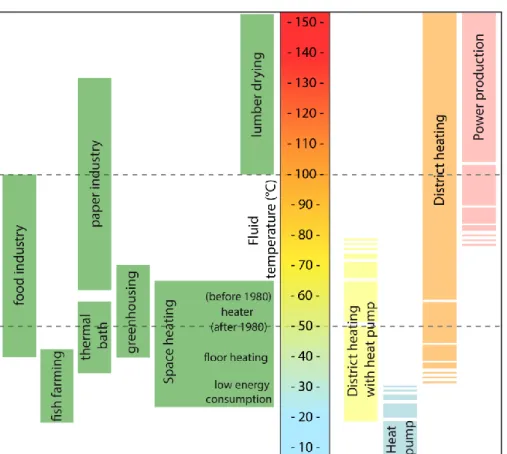
Power generation is not the only use that can be made of geothermal energy. This is especially true concerning low enthalpy resources (< 150 °C) for which the conversion efficiency for power generation is low, between 6.5 and 15 % with ORC plants for fluid temperature between 90 and 150 °C (DiPippo, 2004). This conversion rate depends on the mineralization of the geothermal fluid and on the use of the fluid. Indeed, the conversion rate will be higher if power production is the only purpose of the project than if the heat is also uses i.e. for district heating. Therefore, lots of geothermal projects based on low enthalpy geothermal resources use the heat for different purposes such as thermal bathing, district heating, snow melting or various industrial processes as presented in figure 2.2. This can also be achieved after power production, as geothermal fluid is still hot at the heat exchanger.
Figure 2.2: Uses of geothermal energy for low enthalpy resource at different temperatures (left) and temperature range of different uses (right).
2.1.3 Deep geothermal energy in Switzerland
In Switzerland three types of geothermal resources can be distinguished:
- Shallow depth low-enthalpy resources coupled with heat pumps.
- Resources in Alpine regions.
- Deep geothermal resources in the Swiss Molasse Basin.
The depth at which the distinction between shallow and deep geothermal resources is made in Switzerland may differ between authors but usually ranges between 300 and 500 m (e.g. Rybach and Signorelli, 2010; Vuataz and Fehr, 2000). However, as the resources targeted for the two case studies of the present work are much deeper, they are considered deep aquifers. These case studies being located in the Swiss Molasse Basin, the following geothermal resources and their associated installations will be presented:
- Deep aquifers: low to medium enthalpy hydrothermal reservoirs (figure 2.3, A heat only and C heat and power production)
- Enhanced Geothermal Systems (EGS): medium to high enthalpy
petrothermal reservoirs (figure 2.3, B).
The principle of geothermal projects on deep aquifers is to pump the geothermal fluid naturally present in the permeable rock at depth and to use it for district heating and/or power production. With this aim, generally two boreholes are drilled: one to pump the geothermal fluid (production well) and another (injection well) to push it back into the formation (figure 2.3). This scheme is mainly carried out for two reasons: Firstly, it avoids the treatment of the brine. The Federal Office for Environment (FOEN) recommends a doublet system if the total mineralization of the geothermal fluid exceeds 2
g∙l-1(FOEN, 1998). Secondly, pushing back the fluid into the aquifer allows
keeping the hydraulic pressure within the aquifer unchanged and thus avoids an increase of pumping cost with time. The distance between the two boreholes at depth is calculated to exclude an important thermal breakthrough (cooling of the production well) during the economic lifetime of the installation.
History of geothermal energy in Switzerland
The modern use of geothermal energy for heat production in Switzerland began in the mid-1970s. According to Vuataz and Fehr (2000), before this period geothermal energy exploration and exploitation was limited to very few specialists and projects, and the main use was for spas. Major milestones of the geothermal development in Switzerland are summarized in table 2.2. During the 1970s the first oil crisis occurred leading the Swiss Federal Office of Energy (SFOE) to begin an incentive and promoting policy for renewable energy. Concerning geothermal energy this went mainly through the creation of the “Federal Commission for Geothermics and Underground Heat Storage” (KGS) in 1975. Its task was to clarify scientific, technical and economic aspects concerning geothermal energy and to promote and develop this knowledge (Vuataz and Fehr, 2000). The KGS was involved in various national and international projects and published many studies such as “Geothermische Datensynthese der Schweiz” (Rybach et al., 1981).
However, concerning deep geothermal energy, the interested communities and investors were not able to sustain the high costs and geological risks of deep boreholes. Therefore to help develop geothermal energy on deep aquifers the Swiss federal government decided to create insurance called
“geological risk coverage” for a ten year duration starting in 1988 (Vuataz and Fehr, 2000). This risk insurance was available under the recommendation of the KGS and, in case of partial or total failure of the project (insufficient flow rate), up to 50 % of the drilling and testing costs where refunded. Moreover an incentive measure covering 25 % of these costs was also implemented later. The consequence was a first small boom in the exploration and exploitation of hydrothermal resources with the drilling of 14 deep boreholes (400 to 2600 m) from 1987 to the end of the risk coverage in 1998. From these boreholes, seven are commercially exploited but only four were considered as fully successful (figure 2.4). The first geothermal doublet system in Switzerland in Riehen was one of these. The extension of its district heating to Lörrach across the border with Germany even made this project the first transnational geothermal utilization.
Figure 2.4: Results of the deep geothermal boreholes drilled from 1980 to 1998, as evaluated by the experts of the geological risk coverage. Swiss Coordinates are used, border and background relief courtesy of Swisstopo.
Figure 2.3 (previous page): Possibilities of deep geothermal energy exploitation on the Swiss Molasse Plateau. A. Deep aquifer exploitation for thermal use. B. Enhanced Geothermal system for heat and power production. C. Heat and power production from deep aquifer. 1. Enhanced Geothermal Reservoir; 2. Production and injection boreholes; 3. Heat exchangers; 4. Electricity production: ORC turbine and generator; 5. Air cooler; 6. District heating. The geological profile is modified after (Sommaruga et al., 2012).
In the beginning of the 2000s the growing concern of global warming linked with the extensive use of fossil fuels led the SFOE to start a new 10-year promotional program called SwissEnergy. Its main objective was to decrease fossil fuel consumption, to reduce the growth of electricity demand and to increase electricity production from renewable sources. The basic strategy of the program was to employ voluntary measures to avoid new “command and
control measures” or a CO2 tax (Rybach and Gorhan, 2005). This, together
with the end of the geological risk coverage, led to the situation where no deep drilling occurred in Switzerland for nearly ten years with the exception of the Deep Heat Mining (DHM) project of Basel. Nevertheless, from the 1970s to the start of the 2000s, Switzerland became one of the leaders for geothermal heat production, although most of it was produced by very low enthalpy resources and shallow geothermal installations, mainly borehole heat exchangers for family houses.
In 1996, the EGS Deep Heat Mining project started in Switzerland. Its objective was to artificially create a reservoir at 5 km depth for power generation and to supply heat to district heating. From a selection of ten sites, two were selected for pilot projects: Basel and Geneva. The DHM project of Basel was the first to start and led to the successful drilling of a 5000 m borehole in 2006. However during the stimulation of the reservoir, several seismic events, up to a magnitude of 3.4 frightened the local population and caused some damage to buildings. This led the project being halted. A seismic risk assessment was then commissioned and the project was definitely stopped in 2009. The DHM project of Geneva, which followed the same planning than the project of Basel with a postponement of 2 years, was also stopped due to this event.
Table 2.2: Summary of major dates and events concerning deep geothermal energy in Switzerland until 2009.
Date Event
1975 – 1994 Activity of the Federal Commission for
Geothermics and Underground Heat Storage
1978 Creation of the research group Geothermics and
Radiometrics at ETH Zürich
1987 Start of geological risk guarantee
1990 Foundation of the Swiss Society for Geothermics
(presently Géothermie.ch)
1994 First operational doublet for district heating at
Riehen
1996 – 2006
Deep Heat Mining project in Basel; project stopped after induced seismic event during hydraulic
stimulation in 2006
1998 End of geological risk guarantee
1999 Extension of district heating of Riehen to Lörrach
(Germany)
2001 Initiation of SwissEnergy program
2004 Creation of the CREGE association (Centre de
Recherche en Géothermie, Neuchâtel)
2009
Start of the chair on geothermics, creation of a Master in hydrogeology and geothermics at the
Present situation of deep geothermal energy in Switzerland
The context for deep geothermal projects has changed since 2008, as an electricity gap was expected in the following 5 to 10 years (Wyss and Rybach, 2010). Thus a feed-in tariff for renewable energy and a new risk guarantee were introduced. This guarantee of geological risk will refund a maximum of 50 % of the drilling and testing costs if the objectives are not fulfilled. However, only projects with at least 1.5 % electricity production may apply. This measure combined with the regional geothermal potential studies that were available has created an incentive context for the realization of deep geothermal projects, hydrothermal and petrothermal, targeting combined power and heat production (table 2.3).
This context was reinforced on May 25th 2011, when the Swiss Federal
Assembly decided to get stepwise back out of nuclear energy and to enhance power production by renewable energy (Link et al., 2013). To that purpose, the SFOE established a set of measures called “Swiss Energy Strategy 2050”. In this strategy, due to its important potential, geothermal power production is expected to supply 4400 GWh until 2050. In order to achieve this ambitious goal the main following measures are planned (Link et al., 2013):
- Increase of the risk guarantee to 60 %, covering other costs such as
exploration and increasing of risk guarantee funds.
- Maintenance of the feed-in tariff.
- Create funds for applied research.
- Make available to the public an information system about the deep
underground.
- Intensify public relations.
This new energy law is planned to come into effect in January 2015 but a major legal flaw remains. This concerns the deep geothermal concessions for exploitation and for exploration, which have no specific legal framework. Separately, several cantons have recently started to modify their mining laws and to include geothermal resources in them.
Table 2.3: Recent deep geothermal projects in Switzerland targeting power production (modified after Link et al., 2013). The two case studies of this work are highlighted in gray; [a] EGS projects; [b] Drilling stopped due to an induced seismic event that occurred on June 20th
2014. This seismic event is likely to be linked with actions taken after the detection of a natural gas flow in the borehole (Király et al., 2014).
Project Project developers Phase
Lavey-les-Bains (VD)
Several municipalities and electric utilities
Drilling in preparation Arbon, Romanshorn, Amriswil (TG) Electric power company of canton Thurgau EKT, Axpo
Power AG
Preliminary studies, presently halted
Avenches (VD)[a] Geo-Energie Suisse
AG
Planning phase, public relations
Haute-Sorne (JU) [a] Geo-Energie Suisse
AG
Planning phase, detailed project, public relations
Eclépens(VD) BKW / Sol-E Suisse AG and others Planning phase
Etzwilen (TG)[a] Geo-Energie Suisse AG Planning phase, public relations
Sankt Gallen (SG) Sankt Galler Stadtwerke project haltedDrilling ended, [b]
Herisau-Gossau (SG)
Axpo Power AG, Sankt Galler Stadtwerke, St. Gallisch-Appenzellische Kraftwerke AG Preliminary studies, feasibility study in preparation
Several sites north of
Luzern (LU)[a]
Geo-Energie Suisse AG
Planning phase, public relations
Geothermal exploration and potential studies
The deep underground of Switzerland is not well known as there is almost no exploitation of deep natural resources like oil or mineral ore. The main information comes from oil exploration that occurred from the 1960s to the 1990s with the drilling of deep boreholes and numerous seismic surveys in the Swiss Molasse Basin (see section 2.2 for detail). However these data are mostly proprietary and are not readily available, as every canton has its own legislation. The recent publication of the Seismic Atlas of the Swiss Molasse Basin (Sommaruga et al., 2012) by the Swiss Commission of Geophysics (SGPK) improved this situation by interpreting hundreds of these seismic lines and by making 14 transects and horizon depth maps available to the public and to the geothermal projects.
It is also important to mention that the “National Cooperative for the Disposal of Radioactive Waste” (NAGRA) ran an intensive exploration in the north of Switzerland to find a suitable site for nuclear waste disposal. As NAGRA is a public institution lots of these data are available, even published.
As mentioned, during the very early 2000s no deep geothermal boreholes were drilled with the exception of the DHM Basel project. However interest was still present and during this period several studies assessing the regional geothermal potential were carried out using, essentially, existing data. A selection of these studies is presented in table 2.4. Since 2009, four deep geothermal boreholes have been drilled in Triemli (ZH, 2009), Schlattingen (TG, 2011 and 2013) and in Sankt Gallen (SG, 2013).
R ef er enc e (Ma tt he y, 1986) (R yba ch, 1992) (V ua ta z et a l. , 1993) (G roupe m ent P G V , 2 003) (G roupe m ent P G F , 2005) (S ig nor el li a nd K ohl , 2006) (G eow at t A G , 2007) HS : hot s pr ing s; D A : d ee p aq ui fe rs ; L T : low t em pe ra tur e s ha ll ow d ept h s ys te m s; E G S: E n han ce d ge ot h er m a l sy st em s. SM B : Sw is s M ol as se B a si n. C R E G E : C en tr e d e R ec h er che e n G éo th er m ie , N euc h ât el . C om m iss ione d by S F O E S F O E, K G S C ant on of V al ai s, S F O E C ant on of V aud, S F O E C ant on of F ri bour g S F O E, S G P K C ant on of Zür ic h R esour ce s type HS , D A L T , HS , D A , EG S HS L T , HS , D A , EG S L T , HS , D A , EG S D A , EG S L T , D A , EG S R egi ona l ext ensi on La ke of N euc hâ te l' s coa st li ne S MB C ant on of V al ai s C ant on of V aud C ant on of F ri bour g N or th – Ea st S MB C ant on of Zür ic h N am e R ec he rc he d’ un si te f avor abl e, G ise m ent gé ot he rm ique du L it tor al N euc hâ te loi s G eot he rm al pot ent ia l of t he S w iss Mo la ss e ba si n P rogr am m e G éot he rm ova l Eva lua ti on du pot ent ie l gé ot he rm ique du ca nt on de V aud - P G V Eva lua ti on du pot ent ie l gé ot he rm ique du ca nt on de F ri bour g – P G F G eot he rm isc he r R ess ou rc ena tl as de r N or dsc hw ei z G eot he rm isc he Ene rgi e im K ant on Zür ic h Y ea r 1986 1992 1993 2003 2005 2006 2007
R ef er enc e (B auj ar d et a l. , 2007) (G roupe de t ra va il P G N , 2 008) (D r. R ol and W yss G m bH e t al ., 2009) (G eot he rm ie Espa ce B er n, 2010) (G roupe de t ra va il P D G N , 20 10) (G roupe de t ra va il P G G , 2 011) H S: ho t spr ings ; D A : de ep aq ui fe rs ; L T : low te m p er a tu re shal low de pt h sy st em s; E G S: E nha nc ed ge o th er m a l sy st em s. S M B : Sw is s M ol as se B a si n . C R E G E : C en tr e d e R ec h er che e n G éo th er m ie , N euc h ât el . C om m iss ione d by S F O E, S G P K C R EG E C ant on of Thur ga u and S cha ff ha use n Ene rgi e W ass er B er n C ant on of N euc hâ te l C ant on of G ene va R esour ce s type [a ] D A , EG S L T , HS , DA L T , D A , EG S H S , D A , EG S L T , HS , DA L T , HS , D A , EG S R egi ona l ext ensi on S out h – W est S M B C ant on of N euc hâ te l C ant on of Thur ga u and S cha ff ha use n C ant on of B er n C ant on of N euc hâ te l C ant on of G ene va N am e A tl as de s re ss our ce s gé ot he rm ique s de l a S ui ss e oc ci de nt al e Eva lua ti on du pot ent ie l gé ot he rm ique du ca nt on de N euc hâ te l – P G N G eot he rm ie –P ot enz ia lst udi e Thur ga u -S cha ff ha use n G rundl age nst udi e Tie fe nge ot he rm ie , Espa ce B er n P rogr am m e ca nt ona l de dé ve loppe m ent de l a gé ot he rm ie à N euc hâ te l – P D G N Eva lua ti on du pot ent ie l gé ot he rm ique du ca nt on de G enè ve P G G Y ea r 2007 2008 2009 2010 2010 2011
Geological setting
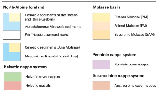
1Our two case studies, Sankt Gallen and Eclépens, are located in the Swiss Molasse Basin (SMB), which extends from the Jura to the Prealps and from Geneva to Lake Constance (figure 2.5). The Swiss Molasse Basin is part of the North Alpine Foreland Basin that runs parallel to the Alpine chain and extends from the region of Savoy (France) in the West to Linz (Austria) in the East (Kuhlemann and Kempf, 2002). Actually, the Western part is a wedge-top basin and the Eastern part a flexural basin. Four major formations occur at depth (e.g. Kempf and Pfiffner, 2004; Kuhlemann and Kempf, 2002; Mazurek et al., 2006): the crystalline basement s.l. (including the Permo-carboniferous often in troughs), its sedimentary cover composed of Mesozoic, Tertiary and Quaternary sediments. These units, whose present day settings are closely linked to the different evolutionary stages of the basin, are briefly described in the following pages from bottom to top and can be viewed in figure 2.6, with the exception of Quaternary deposits.
The crystalline basement originates from the Variscan orogeny and was during and prior to it affected by intensive metamorphism and by hydrothermal alteration (Mazurek et al., 2006). Top basement dips gently from the Vosges and Black Forest Massifs where it outcrops towards the Alps. In the final stage of the Variscan orogeny, during Permo-Carboniferous time, the region was affected by a strike-slip dominated extensional regime which resulted in the formation of 5-20 km wide graben systems filled with fluvial clastic and lacustrine sediments, as well as partly with coal (e.g. Marchant et al., 2005; Mazurek et al., 2006). The thickness of these deposits is highly variable but can reach several hundreds of meters in the troughs (<1500 m, McCann, 2008).
Figure 2.5: (previous page): Main tectonic units of the Swiss Molasse Basin and surrounding areas (after Sommaruga et al., 2012). Red dots represent the geothermal projects of Eclépens and Sankt Gallen. Legend here above.
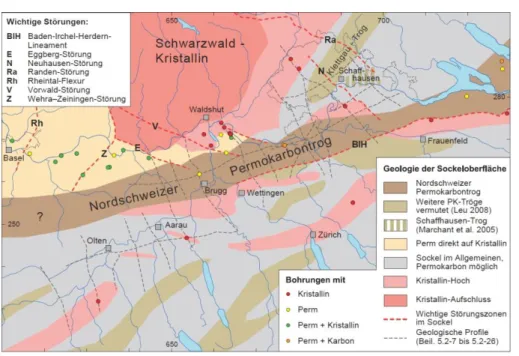
In Northern Switzerland, these graben structures are generally SW-NE to WSW-ENE oriented, e.g. the North-Swiss trough (Diebold and Noack, 1997). This graben is relatively well defined even in its geometry by 2D seismics (NAGRA, 2008; Sommaruga et al., 2012) others are comparably difficult to identify, since seismic evidence is provided by a few internal reflectors only (Marchant et al., 2005). The most complete compilation of these structures in northern Switzerland is given in a technical report of Nagra (NAGRA, 2008). More regional interpretations are also available in McCann (2008) and Ustazewski (2004). However, the definition of the trough is slightly different in the two interpretations. In figure 2.7 (NAGRA), the troughs are identified at places where Carboniferous sediments were found in wells. In the other studies a trough is only considered when the estimated thickness of the Permo-Carboniferous sediments is greater than 250 m (Ustazewski, 2004).
In the vicinity of Sankt Gallen and Eclépens only uncertain localization of Permo-Carboniferous graben structures are indicated from 2D seismic (Sommaruga et al., 2012). Due to difficult identification, the crystalline basement and the Permo-Carboniferous grabens are often regrouped under the name “basement s.l.”.
Figure 2.6 (previous page): a) Cross-section of the northeastern Swiss Molasse Basin. b) Cross-section of the south-western basin. Profile location see figure 2.5 (Sommaruga et al., 2012).
Figure 2.7: Late Paleozoic troughs and highs in the southernmost Upper Rhine Graben and adjacent areas (NAGRA, 2008).
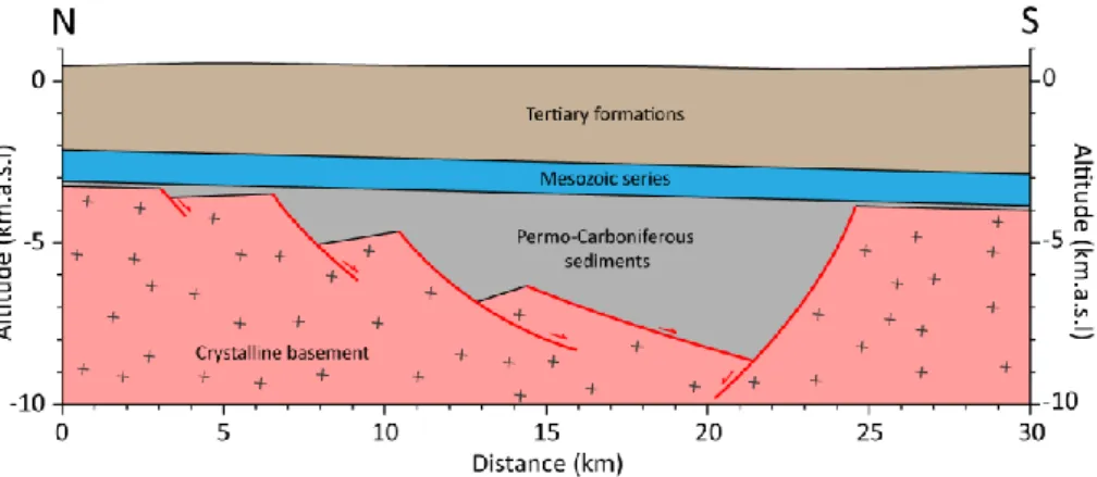
Concerning the geometry of the trough, based on the North-Swiss Graben, they seem to be highly asymmetrical with borders of different geometry as illustrated in figure 2.8. Moreover, the thickness of the deposits varies considerably from nothing or a few meters on the trough’s shoulder to several kilometers at the thickest part. The faults linked with these structures are likely of variable geometry and importance but can be of high interest for geothermal exploration as they can allows fluids convection. Sommaruga et al. (2012) mention that in the western SMB the Permo-Carboniferous grabens seems to be a rather narrow sized flat ramp with steep borders.
Figure 2.8: Schematic illustration of a Permo-Carboniferous graben in the Swiss Molasse Basin. Red lines represent faults.
On top of the crystalline basement s.l., continental sandstones of the Buntsandstein formation underlay the Triassic marine sediments of the Muschelkalk formation (Chevalier et al., 2010). During this period mainly dolomite, clays, marls, sandstone and limestone were deposited in an epi-continental sea (NAGRA, 2008). Evaporites were also deposited during Triassic; however this concerns mainly the area north of the Lausanne-Zürich-Munich line and therefore will be treated in more detail for the case study of Eclépens. The collision of the European and the Adriatic plate caused the bending and bulging of the European plate and this led to the exhumation of the Mesozoic and Cretaceous formations.
Thus, part of these sediments was exposed to weathering and karstification especially in the eastern part of the basin (Mazurek et al., 2006; Pfiffner, 2010). This together with differences in deposition thickness leads to a diminution factor of four regarding the thickness of the Mesozoic layers from Lake Geneva to Lake Constance (Sommaruga et al., 2012). It furthermore caused the erosion of most of the Cretaceous deposits (figure 2.5) and part of the Malm formations.
During the Tertiary, the Swiss Molasse Basin was filled during two cycles with detrital sediments resulting from the erosion of the Alps and shallow marine deposits during sea ingression. These sediments are mainly composed of turbiditic series, sandstone, sandy marls and conglomerates and divided into four successive depositional groups (Berger et al., 2005a, 2005b; Burkhard, 1990; Homewood et al., 1986; Kempf et al., 1999; Kempf and Pfiffner, 2004; Kuhlemann and Kempf, 2002; Mazurek et al., 2006; Pfiffner, 1986a). In ascending stratigraphic order these are: Lower Marine Molasse (UMM); Lower Freshwater Molasse (USM); Upper Marine Molasse (OMM); Upper Freshwater Molasse (OSM). In terms of structural units, three types can be distinguished: the well bedded, erected, and the anticline of the sub-Alpine molasses (Berger et al., 2005a, 2005b; Burkhard, 1990).
In the Swiss Molasse Basin, Quaternary deposits are linked with glaciers and hydrology. In the region of our two case studies their extension is typically relatively small and local. They will therefore be presented in detail for each of the case studies.
2.2.1 Hydrogeology
Hydrogeological properties of the different geological layers of the SMB have been studied for different reasons: nuclear waste disposal by NAGRA (e.g.
NAGRA, 2008), CO2 storage (Chevalier et al., 2010). Their potential for
geothermal exploitation (table 2.4) has been evaluated by Baujard et al. (2007), Signorelli and Kohl (2006), and Rybach (1992). They also have been studied on a more local scale for the geothermal potential studies (table 2.4): Bern, Fribourg, Geneva, Neuchâtel, Thurgau, Vaud, and Zürich. Table 2.5 presents the different potential aquifer formations of the SMB together with the commonly admitted name of the aquifer (e.g. Chevalier et al., 2010), which is used in this work. These formations are presented in table 2.5 and figure 2.9 from the youngest to the oldest.
Table 2.5: Potential aquifer formations of the SMB from the youngest to the oldest. The commonly admitted aquifer’s name is given for further use in the text.
Geological formation Aquifer’s name
Sandstone of the OMM (Early Miocene) OMM
Limestones and dolomites of the lower
Cretaceous Cretaceous
Limestones of the Upper Malm Malm
Limestones of the Dogger Dogger
Limestones and dolomites of the Upper
Muschelkalk Muschekalk
Sandstone of the Buntsandstein Bunsandstein
Altered and/or fractured Ante-Triassic
crystalline rocks of the basement Crystalline basement
OMM
This formation is a well-known porous potential aquifer in the East of Switzerland, where it is exploited for drinking water and sometimes for heat. An example of its combined use can be found in Seon (AG), where water is pumped at 300 m with a temperature of 19.5 °C from a single borehole. Water is then cooled to 10 °C by a heat pump; this allows heating of several buildings before being used as drinking water. However in most cases this Tertiary unit is quite shallow and therefore does not represent a target for major geothermal projects, even if the quality of the water allows its exploitation from a single borehole without reinjection.
Cretaceous
In the Jura Mountains, the lower Cretaceous limestone is a well-known, essentially karstic, aquifer but is often not considered for geothermal projects for the following reasons. Firstly, as shown on figure 2.5 the Cretaceous formation is only present in some parts of the basin. Secondly, the karst and fractures can be filled with deposits resulting from its erosion or secondary mineral transferred by fluid flow, as it is the case in the Thônex (canton of Geneva) borehole (Jenny et al., 1995). Finally this formation is often too shallow to be exploited without heat pumps, even if it can still be interesting for low to medium depths projects.
Figure 2.9 (next page): Generalized stratigraphic column (not to scale) of the Swiss Molasse Basin and the adjacent Folded Jura with aquifer properties. Aquifers are blue, aquitards orange, from Chevalier et al. (2010).
Upper Malm
The name Upper Malm is often given to the potential aquifer of the Kimmeridgian and Portlandian formations. These formations are composed of limestones and dolomites (Portlandian only) and can be an aquifer especially when affected by fractures and/or karstification. This represents the main aquifer for drinking water all along the Jura range. Moreover, this formation reveals aquifer properties to considerable depths greater than 3300 m in Germany and Austria (e.g. Schellschmidt et al., 2010). In Switzerland an important number of wells were drilled in the Malm (e.g. Muralt, 1999) especially near the foot of the Jura range for different reasons: water prospection, oil exploration or geothermal prospection. This leads to a relatively good knowledge of its aquifer properties. Due to its important thickness and to the major infiltrating area in the Jura Mountains, this aquifer has been the main target of several geothermal projects in Switzerland.
Dogger
The Dogger series are also a well-known aquifer in the Jura Mountains, where they have been drilled for drinking water e.g. at Muriaux (canton of Jura, Hessenauer et al., 2001). Several formations of the Dogger series represent potential aquifers, but the only ones that can be of regional importance are the “Dalle nacrée” (Callovian) and the “Hauptrogenstein” of Bajocian – Bathonian (figure 2.9). However there are significant and rapid facies changes in these formations, resulting in considerable spatial variations of the hydrogeological parameters. For example, at Yverdon-les-Bains, the geothermal well F5 reached the Bajocian formations, which was composed of a micritic limestone, whereas at 3 km in the oil exploration well of Treycovagnes it was an oolithic limestone (Vuataz et al., 1999). Therefore Dogger formations are not commonly considered as a major and regional target a geothermal project.
Muschelkalk
The Muschelkalk is a well-known aquifer in the north-eastern Jura, where it was the target of three geothermal projects, two of which were successful. This aquifer is hosted by limestones and dolomites of the Upper Muschelkalk, representing generally a total thickness of more than 70 m (Burger and Gorhan, 1986). This aquifer is often considered as the main target for deep geothermal project (e.g. Baujard et al., 2007; Signorelli and Kohl, 2006) due to the relative evenness of it characteristics, such as thickness and aquifer properties In Riehen (canton of Basel Stadt) it has been used for district heating since 1994 and in Schinznach Bad (canton of Aargau), the resource is used for thermal bathing and space heating (Sonney and Vuataz, 2008).
Buntsandstein and crystalline basement
Buntsandstein represents the most basal formation of the Mesozoic. It is a sandstone formed by the alteration of the basement and was recognized as an aquifer east of Geneva in France i.e. in the Charmont-1 well (PGG, 2011) and in northern Switzerland. Schmassmann et al. (1992) established that there is a hydraulic connection between the altered basement aquifer and the Buntsandstein. Therefore where Buntsandstein overlies crystalline basement they form together a single aquifer, but where it overlies Permo-Carboniferous sediments, Buntsandstein alone must be considered. The aquifer parameters of the altered crystalline basement have been studied by NAGRA in northern Switzerland, where it shows a considerable permeability heterogeneity (Pearson et al., 1991; Schmassmann et al., 1992; Signorelli and Kohl, 2006), but could be an interesting aquifer for geothermal projects in several regions of Switzerland, although information about this formation is quite limited (Baujard et al., 2007).
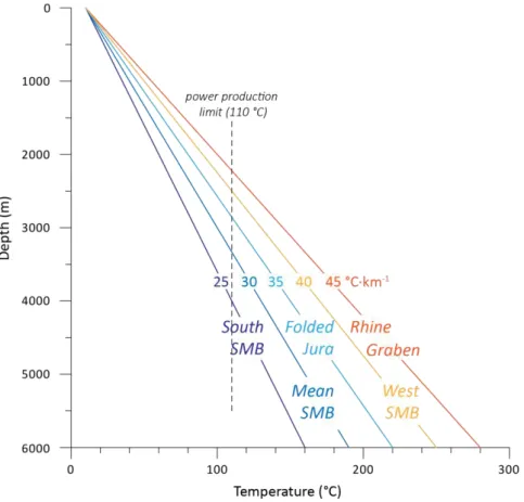
2.2.2 Geothermal condition under the SMB
In the Swiss Molasse Basin the geothermal gradient is considered mostly
normal (30 °C·km-1), with regional or local values ranging from 25 to
Figure 2.10:Geothermal gradient data from Switzerland in °C·km-1(Rybach, 1992).
Figure 2.11: Range of the mean regional geothermal gradients in the Swiss Molasse Basin (SMB) (after Chevalier et al., 2010).
Gravity exploration
The gravity method is based on accurate measurement of the vertical component of the Earth gravity field and their interpretation to detect underground variations of density. This method has a variety of applications, which are principally geodesy, determination of deep earth structures and geophysical exploration. It was historically firstly used for geodesy.
2.3.1 History
The history of gravity method is most often divided into four broad and overlapping periods (Hinze et al., 2013), which are strongly related to technological innovation. It is not the purpose of this work to give a complete review of the gravity method history, but to present it briefly in order to give context to the proposed methodology.
First period: Renaissance – end of the 19th century
The interest in gravity measurements began in ancient Greece when Aristotle made the distinction between heavy (i.e., stones) and light bodies (i.e.,
feather). Things remained almost the same until the end of the 16th century
when Galileo Galilei wrote his theory of the falling of bodies. Legend says that he let heavy and light objects fall from the tower of Pisa and then measured the time of the fall. In fact, he performed this experiment on an inclined plane. Nevertheless, this allowed him to conclude that the time was the same for every object regardless of its weight and was thus the first approach of the effect of the Earth gravity field. It is therefore the date marking the beginning of the first development of the gravity method development. A century later in 1687, Sir Isaac Newton published his famous Philosophiae Naturalis Pricipis Mathematica. In this work, Newton explained for the first time the law of universal gravitation, which allows the calculation of the force of attraction between two bodies.
Nevertheless, the founding father of gravity measurements is Pierre Bouguer (1698-1758) a French mathematician. In 1735, he undertook a scientific expedition to Peru with Charles Marie La Condemine, Louis Godin and Joseph de Jussieu to measure a degree of the meridian arc near the equator. This expedition allowed Bouguer to establish many of the basic gravitational relationships including the "free air correction", "plate correction" (often called Bouguer plate) and also the mass of the Earth. He also succeeded in measuring gravity at several points. Bouguer also tried to measure the attraction of a single mountain in Chimborazo, but he made some mistakes in
his calculations, which led him to failure (Goguel, 1984). This experiment was made by measuring the deviation of the vertical in two far away points near the mountain with a pendulum.
Second period 1800 – 1950
The first gravimeter was the Kater's pendulum introduced in 1817 by the physicist and Captain Henry Kater. The center of gravity and the center of oscillation were not fixed, this allowed more precision in gravity measurements. Then in 1890, Baron Roland von Eötvös, a Hungarian physicist, developed a torsion balance, which allowed the measurement of differences in gravity between two points rather than the total value of gravity. Before the invention of modern gravimeters in 1940, numerous gravity measurements were made using both systems, but the difference between absolute and differential gravimeter remained.
The availability of more portable instruments and their increased precision allowed, in the first years of the 1900s, to use gravity measurements for subsurface studies. This led to an important increase of gravity measurements and the torsion balance was used for oil exploration from the end of World War I. According to Nabighian et al. (2005) it was used over a salt dome in Germany in 1918 and the instrument was then bought as war reparation and used in the USA. In 1922, this led to the first oil discovery by geophysical method in America when it was used over the Nash dome in Texas (Hinze et al., 2013).
During the first half on the 20th century gravity was thus extensively used in
oil exploration, which allowed the establishment of the concepts of mapping geology with gravity and the basic principle of gravity data processing. During this period, international standard data reduction for pendulum and gravimeter were internationally accepted and the Gal was accepted as the CGS system (Centimeter Gram Second system) unit for acceleration. The next step in the development of the gravity method was done through the works of L. L. Nettleton (1939, 1940, 1942) and of S. Hammer (1939, 1945, 1950) which are critical in gravity exploration and for density determination. During this period instruments were also improved with the discovery of the zero length spring of L. J. B. La Coste (1934) which made the relative gravimeter easier to use and to calibrate (Nabighian et al., 2005).
Third period: 1950s – 1980
The development of gyrostabilized gravity platforms in 1960 allowed extensive measurements on moving platforms such as planes and ships (Hinze
et al., 2013). Nevertheless, this period is mainly marked by the rapid increase in digital computational capacity and speed; this led to improvements in the processing and modeling of gravity data. This resulted in the development of algorithms for the computation of the gravity effect of 2D and 3D arbitrary shapes (e.g. Talwani et al., 1959) and thus allowed forward and inverse calculation. The increase of computer capacity also permitted the use of Fourier transforms for potential field analysis. From the 1970s the use of geographic information systems (GIS) allowed better representation and understanding of the multiple geological and geophysical data.
Fourth period: 1980s – today
As this period is still ongoing, the present methodology used in gravity exploration will be presented in the next sections of this work. However, we must highlight some of the major changes that have occurred during this period. Firstly the availability of cheaper workstations and personal computers allowed migrating computer software to these platforms (Unix and Windows). The emergence of the personal computer and of the internet resulted in better access to previous gravity data sets (commercial or scientific) and to Digital Elevation Models (DEM), which are becoming far more accurate (see section 3.2.1 dedicated to terrain correction). This has also resulted in faster data processing and interpretation.
Finally, the instrumentation has evolved and gravity can now be acquired with high precision digital gravimeters using a quartz sensor with partially automated levelling such as the relative gravimeter CG-5 from Scintrex Ltd. used during this study with an accuracy of 5 µGal. Positioning of the gravity measurements stations has also evolved with the discontinuing degradation of the GPS signal in 2000 which allows high-accuracy surveys. Presently, the use of real-time correction gives an almost instantaneous precision to a few centimeters in three dimensions.
Regarding geothermal exploration, gravity has also been used in combination with magnetotelluric methods to help identify deep geothermal aquifers linked with faults (Tulinius et al., 2008) and in the Alps (Guglielmetti, 2012; Guglielmetti et al., 2013). Filtering of gravity data was also use by Abdelfettah et al. (2014) in order to characterize geothermally relevant structure in the crystalline basement in Switzerland. Finally, Bailleux et al. (2013) used gravity data in order to localize temperature anomalies in the Upper Rhein Graben.
2.3.2 Theory
The theory of gravity measurements is presented extensively in literature (e.g. Hinze et al., 2013; Kearey et al., 2009; Reynolds, 1997; Telford and Sheriff, 1990). In the following section, we will summarize some important considerations in order to better explain the methodology used in the present work.
Physical basis
Basically the gravity force between two bodies is expressed by Newton’s Law of Universal Gravitation presented here after:
𝐹 = 𝐺𝑀1𝑀2
𝑑2 (2.1)
with F: the attraction force in kg∙m∙s-2; G: the universal gravitation constant
6.674∙10-11 m3∙kg-1∙s-2; M
1, M2: the respective mass of the two bodies in kg; d:
the distance between the center of the bodies in m.
The acceleration implied by a force is expressed by Newton’s Second Law of Motion:
𝐹 = 𝑚 ∙ 𝑎 (2.2)
where F is the force acting on a body in kg∙m∙s-2; m: the mass of the body in
kg; a: the acceleration in m∙s-2. In the case of a point mass at the surface of the
Earth equation 2.1 and 2.2 can be combined in order to calculate the acceleration induced by the Earth (g in equation 2.3):
𝐹 = 𝐺𝑀𝑒∙ 𝑚
𝑅2 = 𝑚 ∙ 𝑔 → 𝑔 = 𝐺
𝑀𝑒
𝑅2 (2.3)
with F: attraction force in kg∙m∙s-2; G: the universal gravitation constant
6.674∙10-11 m3∙kg-1∙s-2; M
e, m: the mass of the Earth and of the body
respectively in kg; g: the acceleration in m∙s-2; R: the radius of the Earth in m.
Equation 2.3 shows that earth’s acceleration is independent from the mass of the body and is proportional to the Earth mass and radius. The acceleration of gravity is a conservative vector field, which implies that the work needed by a particle to go from point A to point B is independent from its route and is
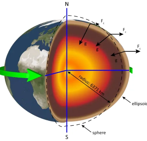
the product of the force of gravity by the displacement. With this consideration, we are able to calculate the gravitational potential of a punctual body everywhere in the gravitational field. It allows us to plot equipotential curves. These equipotential curves connect all points in space where the gravitational potential of a body of constant mass is the same and is called an equipotential surface. In the case of a motionless and spherical (or with layered densities) earth, this surface is a sphere. However, the Earth rotates on itself and this has two main effects concerning the measurement of gravity: the rotation implies a centripetal acceleration that will be opposed to gravity and will be at its maximum at the equator and null at the poles (figure 2.12). The rotation also deforms the Earth which is therefore more an ellipsoid than a perfect sphere. This induced radius difference is 21 km between the poles and the equator.
Figure 2.12: Difference between spherical Earth and ellipsoid and its consequences on gravity (not to scale); g: gravity neglecting effect of rotation; Fc: centrifugal force.