Proceedings of the 12th Jan Tinbergen European Peace
Science Conference
Topher McDougal* and Raul Caruso
Wartime Violence and Post-Conflict Political
Mobilization in Mozambique
Abstract: Mozambique’s post-conflict development has recently focused on the promise of biofuels production, and the Government of Mozambique has accord-ingly made hundreds of agricultural concessions to foreign and domestic cor-porations since 2006. In response, local groups have sought community land grants to protect livelihoods. We seek to understand whether the magnitude and recentness of violent events during Mozambique’s 16-year civil war determined the success of communities’ efforts to secure lands. We hypothesize that violence weakens the ability of communities to protect their traditional land uses from concessions by lobbying for community land grants. This hypothesis – dubbed the “weak institutions hypothesis” – is contrasted with the idea that violence gal-vanizes political participation. We test the hypothesis using GIS-generated data at the district level on recognized community landholdings and civil war events. Controlling for factors such as market access, road distance to grain warehouses, and spatial auto-correlation, we find that more intense violence is possibly (but not significantly) associated with more land grants, and that districts experienc-ing more recent violence are actually more likely to lobby successfully for land grants – lending support to the idea that violence boosts community use of risk-pooling institutions.
JEL Classification: D71, N47, N57, O13, O25, Q15, Q16, Q18
Corresponding author: Topher McDougal: Joan B. Kroc School of Peace Studies, University of San Diego, USA, Center on Conflict, Development, and Peacebuilding, Graduate Institute of International and Development Studies, Geneva, Switzerland, Tel.: +1 617 642 5842; fax +1 617 849 8109. E-mail address: tlm@sandiego.edu.
Raul Caruso: Institute for Economic Policy, Catholic University of the Sacred Heart, Milan This paper represents an abridged version of a paper presented at the 12th Annual Jan Tinber-gen European Peace Science Conference at DIW, Berlin, Germany, on 25 June 2012. See McDou-gal and Caruso (2012). The authors gratefully acknowledge Patrick Domingues of the University of Paris I Panthéon – Sorbonne for generously sharing his Mozambican Civil War dataset (see Domingues, 2011). We also thank Brian Estabrook, Sara Johnson and Lars Stairs-Almquist at the Kroc School of Peace Studies, San Diego, for their assistance with background research. We are
grateful for the many comments we received from participants at the Jan Tinbergen European Peace Science Conference in June of 2012, as well as the valuable suggestions from Vincenzo Bove and Andrea Ruggeri.
1 Introduction
Does the violence of war depress the ability of communities to influence post-con-flict development policy effectively, thereby dooming the most conpost-con-flict-affected areas to bear the brunt of the costs of future development? Or, on the other hand, do the communities who suffered most in the war, whether because it generates greater internal social cohesion or heightened general political participation rates, enjoy an enhanced ability to shape the implementation of future devel-opment policy? The answers will bear on the important issue rebuilding post-war political institutions (Sambanis, 2002): if the former scenario is the case, we might expect the dynamics of the war may be reproduced without some purpose-ful intervention. If the latter scenario is the case, we might tentatively conclude that war sews the seeds of its own autonomous recovery in some way (see, e.g., Weinstein, 2005).
This paper analyzes a cross-sectional, GIS-generated dataset designed to capture the spatial effects of violence on the distribution of agricultural land con-cessions to corporations at the district level in Mozambique. Mozambique has made tremendous development strides since the termination of its 16-year civil war in the early 1990s. Since 2006, the Government of Mozambique (GoM) has controversially begun according land concessions to biofuels corporations foreign and domestic (Schut, Slingerland, & Locke, 2010) – a land use that competes with local agriculture, which tends to focus on food production (Deininger, et al., 2011, Estabrook, 2011). The resulting concern over food security has prompted some international NGOs to cry foul (Oxfam International, 2007), and motivated many local communities to oppose the concessions and press the government to rec-ognize their claims to the land with community land grants (see Deininger, et al., 2011, p. 189). Assuming that all communities wish to secure lands in their districts, we exploit the spatial variation in the distribution of community land grants to assess the effects of wartime violence on the effectiveness of local politi-cal mobilization.
2 Background: The Debate
We hypothesize that violence weakens the ability of communities to oppose the redistribution of land from traditional to industrial uses via concessions. This hypothesis – dubbed the “weak institutions hypothesis” – is contrasted with the idea that violence galvanizes political participation. Many scholars contend that civil wars in developing nations can precipitate (and result from) the degeneration and/or perversion of national-level governance institutions needed for long-term development and accountability (Collier, et al., 2003, Humphreys, 2005, p. 512, Reno, 1997, 1999, 2003) – particularly when weak governments receive outside support and are therefore unaccountable to the tax-paying public (Humphreys, 2003, p. 13). At the micro level, Brück (2003) argues that certain household char-acteristics – for instance, being headed by a woman – effectively limit land access in Mozambique, and that war heightens the magnitude of those effects. At the individual level, exposure to civil war is a significant predictor of future violent behavior (Miguel, Saiegh, & Satyanath, 2011), which may erode social cohesion and thereby the effectiveness of community institutions.
Conversely, some evidence suggests that the adverse effects of wartime vio-lence on local economic growth tend not to persist, due to “rebound effects” (Davis & Weinstein, 2002). Bellows and Miguel (2008) argue that measures of local political mobilization, like community meeting attendance, memberships in local political groups, and voting, are higher in Sierra Leonean households that directly experienced more intense violence than those that experienced less or none. On the other hand, political mobilization at the individual level does not necessarily proxy well for the effectiveness, transparency, or inclusiveness of local institutions, and there is some evidence that violent conflict may provoke negative coping mechanisms in local institutions, resulting in the exclusion or even persecution of certain sub-populations (Krause, 2010).
Stated succinctly then, in our context, the “weak institutions” hypothesis
(HWI) we test is: The greater the intensity of violence that occurred within a district,
the smaller the total area of community land grants will be.
3 Empirical Strategy
We employed a cross-sectional, district-level dataset with 142 observations, which include all rural and major metropolitan districts. The sources of the data vary and are noted below, but special mention is made of the Domingues (2011) dataset on Mozambican war events, which exclusively informs the war-related
predictor variables. The latter include the indices for battle intensity, and rebel and government troop presences, which were created by assigning a value of 2 to battles or the establishment of rebel/ government headquarters, 1 to the occur-rence of “one-sided” violence or reports of troop movements and encampments, and then summing the scores for all events in that district. The outcome variable – community land grant area awarded in kilometers – is derived from the World Bank report by Deininger et al. (2011) and a geographic information system (GIS) shapefile that informed that report. The mean area of community land grants
awarded is about 500 km2 per district, but the distribution is heavily left skewed
(skewness = 3.7), with the median at zero, and even the 75th percentile about half
the mean, at 225 km2. Figure 1 illustrates the distribution of community land
grants. All data were generated in a GIS using ArcGIS software.1
In order to test the “weak institutions” hypothesis, we distinguish between districts in which violence took place on the one hand, and districts that hosted or otherwise supported rebel and government forces on the other (which we control for separately). Many control variables are also included in the dataset, most of which – such as distance by road to the nearest city, distance to the nearest grain warehouse, and spatial autocorrelation corrections – were generated in a GIS.
1 A codebook is available from the corresponding author upon request.
0 20 40 60 80 100 Fr eq ue nc y 0 2000 4000 6000 8000
Area of community land grants (Km2)
Table 1 gives some descriptive statistics of the outcome and primary predictor variables. The outcome variable’s distribution is heavily skewed, it includes an abundance of zeros, and its variance is greater than the mean, suggesting our use of a negative binomial GLM with a log link.
Following Ver Hoeff and Boveng (2007), the outcome variable is denoted as exhibiting a negative binomial (NB) distribution as Y~NB(μ,κ), parameterized such that
E(Y)=μ
var(Y)=νNB (μ)=μ+κμ2, (1)
where μ is the mean of the distribution, κ is a dispersion parameter, and μ>0 and κ>0. The relationship between E(Yi), the expected number square kilometers of community land grants in district , and , the intensity of violence in district i, in a NB model can be expressed
E(Yi ) = μi = exp(β0 + αHWISCOREi + β1Xi1 + β2Xi2 + ... + βqXiq + εi), (2) where and are regression coefficients, and are control variables.
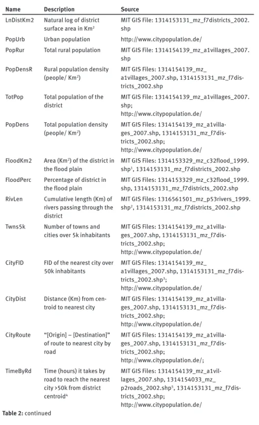
Control variables, listed in Table 2, included in the dataset were mostly generated in a GIS, and include demographic (i.e., rural population density), geographic (e.g., total length of major rivers within a district), and market access (e.g., distance to the nearest grain warehouse) attributes. Distances were
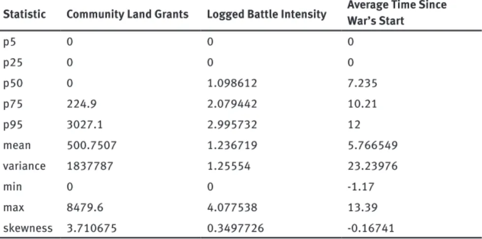
Statistic Community Land Grants Logged Battle Intensity Average Time Since War’s Start
p5 0 0 0 p25 0 0 0 p50 0 1.098612 7.235 p75 224.9 2.079442 10.21 p95 3027.1 2.995732 12 mean 500.7507 1.236719 5.766549 variance 1837787 1.25554 23.23976 min 0 0 -1.17 max 8479.6 4.077538 13.39 skewness 3.710675 0.3497726 -0.16741
Table 1: Descriptive statistics for area of community land grants (Km2), logged battle intensity, and average time (in years) elapsed from war’s beginning to violence in that district.
Name Description Source LnDistKm2 Natural log of district
surface area in Km2
MIT GIS File: 1314153131_mz_f7districts_2002. shp
PopUrb Urban population http://www.citypopulation.de/
PopRur Total rural population MIT GIS File: 1314154139_mz_a1villages_2007. shp
PopDensR Rural population density (people/ Km2)
MIT GIS Files: 1314154139_mz_
a1villages_2007.shp, 1314153131_mz_f7dis-tricts_2002.shp
TotPop Total population of the
district MIT GIS File: 1314154139_mz_a1villages_2007.shp; http://www.citypopulation.de/
PopDens Total population density
(people/ Km2) MIT GIS Files: 1314154139_mz_a1villa-ges_2007.shp, 1314153131_mz_f7dis-tricts_2002.shp;
http://www.citypopulation.de/ FloodKm2 Area (Km2) of the district in
the flood plain MIT GIS Files: 1314153329_mz_c32flood_1999.shp1, 1314153131_mz_f7districts_2002.shp FloodPerc Percentage of district in
the flood plain MIT GIS Files: 1314153329_mz_c32flood_1999.shp, 1314153131_mz_f7districts_2002.shp RivLen Cumulative length (Km) of
rivers passing through the district
MIT GIS Files: 1316561501_mz_p53rivers_1999. shp2, 1314153131_mz_f7districts_2002.shp Twns5k Number of towns and
cities over 5k inhabitants MIT GIS Files: 1314154139_mz_a1villa-ges_2007.shp, 1314153131_mz_f7dis-tricts_2002.shp;
http://www.citypopulation.de/ CityFID FID of the nearest city over
50k inhabitants MIT GIS Files: 1314154139_mz_a1villages_2007.shp, 1314153131_mz_f7dis-tricts_2002.shp3;
http://www.citypopulation.de/ CityDist Distance (Km) from
cen-troid to nearest city MIT GIS Files: 1314154139_mz_a1villa-ges_2007.shp, 1314153131_mz_f7dis-tricts_2002.shp;
http://www.citypopulation.de/ CityRoute “[Origin] – [Destination]”
of route to nearest city by road
MIT GIS Files: 1314154139_mz_a1villa-ges_2007.shp, 1314153131_mz_f7dis-tricts_2002.shp;
http://www.citypopulation.de/; TimeByRd Time (hours) it takes by
road to reach the nearest city >50k from district centroid4
MIT GIS Files: 1314154139_mz_a1vil-lages_2007.shp, 1314154033_mz_ p2roads_2002.shp5, 1314153131_mz_f7dis-tricts_2002.shp;
http://www.citypopulation.de/ Table 2: continued
calculated by way of a road network analysis, taking the centroid of the district as the point of departure to any given destination. Spatial autocorrelation was also controlled for by way of an inverse distance-weighted matrix of community land grant magnitudes.
DistByRd Distance (Km) by road to the nearest city >50k from district centroid
MIT GIS Files: 1314154139_mz_a1vil-lages_2007.shp, 1314154033_mz_ p2roads_2002.shp, 1314153131_mz_f7dis-tricts_2002.shp;
http://www.citypopulation.de/ WHFID FID number of nearest
food warehouse MIT GIS Files: 1314153131_mz_f7dis-tricts_2002.shp, 1314153361_mz_g17warehouses_1999.shp WHDist Distance (Km) from district
centroid to nearest food warehouse
MIT GIS Files: 1314153131_mz_f7dis-tricts_2002.shp,
1314153361_mz_g17warehouses_1999.shp CapDist Distance (Km) from district
centroid to capital city (Maputo)
MIT GIS Files: 1314154139_mz_a1villa-ges_2007.shp, 1314153131_mz_f7dis-tricts_2002.shp;
http://www.citypopulation.de/ NGOFID FID number of nearest
NGO field office MIT GIS Files: 1314153131_mz_f7dis-tricts_2002.shp, 1314153540_mz_e624ngos_2004.shp NGODist Distance (Km) from district
centroid to nearest NGO field office
MIT GIS Files: 1314153131_mz_f7dis-tricts_2002.shp,
1314153540_mz_e624ngos_2004.shp6 WFPFID FID number of nearest
World Food Programme (WFP) office
MIT GIS Files: 1314153131_mz_f7dis-tricts_2002.shp,
1314154113_mz_e624unwfp_1999.shp7 WFPDist Distance (Km) from district
centroid to nearest WFP office
MIT GIS Files: 1314153131_mz_f7dis-tricts_2002.shp,
1314154113_mz_e624unwfp_1999.shp Table 2: Control variables by name, description, and source.
1. “Mozambique (Flood Region, 1999)”, created 11 February 1999. 2. “Mozambique (Major Rivers, 1999)”, created 30 January 1999.
3. Centroids were created for each district, which serve as the basis for all distance measurements to follow. 4. Using a network analysis, assuming that highways allow for speeds of 90 Km/hr, primary roads 65 Km/hr,
and dirt paths 35 Km/hr.
5. “Mozambique (Roads, 2002)”, created 12 March 2002. 6. “Mozambique (NGO Offices, 2004)”, created 14 September 2004.
4 Results
Table 2 reports the results. Uncontrolled models include only those variables that are visible in the table. Controlled models also include those described above and in Table 2. In models 1-4, the extent that a district suffered wartime violence is an extremely significant, positive predictor of community land grant awards. Moreover, when a time dimension is tested for in models 2 and 4, the recentness of violence also is an extremely significant, positive predictor of community land grant awards. Both of these findings possibly suggest that violence does indeed galvanize, rather than undermine, community political mobilization. In con-trolled regressions, however, only in the model that includes the time variable but excludes all alternative hypothesis variables (column 6) does wartime violence continue to be a significant, positive predictor of community land grants, though the coefficient never dips into negative territory. Overall, wartime violence seems to have a neutral, or possibly positive, effect on the formation of community land grants, suggesting that our initial hypothesis should be rejected.
The recentness of violence seems to be more unequivocal in its effects, improving a district’s efforts at mobilization for community lands across the board. Figure 1 illustrates this phenomenon: heavily and recently conflict-affected
0 50 00 10 000 15 000 A rea of C om m un ity Lan d G ran ts (K m 2) 0 5 10 15
Avg. Years Since War's Start Low Battle Intensity Medium Battle Intensity High Battle Intensity
Figure 2: Adjusted predictions of community land grants in Km2 by average years since vio-lence, by low (5th %ile), medium (50th %ile) and high (95th %ile) battle intensity. Based on Model 8. Source: The authors, based on Model 2(8).
Unc ont ro lled Model s Cont ro lled Model s LABELS (1) (2) (3) (4) (5) (6) (7) (8) Log B attle Int en sity Sc or e 0.322*** (0.0720) 0.476*** (0.118) 0.378*** (0.0775) 0.557*** (0.131) 0.00401 (0.131) 0.310* (0.179) 0.00152 (0.139) 0.265 (0.189) Log Go vernment Tr oop Pr esenc es Inde x -1.342*** (0.451) -1.407 (1.104) -0.0257 (0.607) -4.266*** (1.349) Log R ebel Pr esenc es Inde x -0.216 (0.183) -0.757 (0.515) 0.0444 (0.217) 0.622 (0.633) Ye ar s Sinc e W ar‘s Beginning (B attle s) -0.0479* (0.0274) -0.0536* (0.0290) -0.103*** (0.0389) -0.0996*** (0.0384) Ye ar s Sinc e W ar‘s Beginning (Go v‘t Pr esenc es) 0.0290 (0.0881) 0.325*** (0.109) Ye ar s Sinc e W ar‘s Beginning (R ebel Pr esenc es) 0.0930 (0.0854) -0.0898 (0.102) Con st ant 4.871*** (0.123) 4.945*** (0.134) 4.886*** (0.123) 4.946*** (0.136) 7.415* (4.137) 6.722 (4.181) 7.341* (4.159) 6.693 (4.151) Ob ser vation s 142 142 142 142 142 142 142 142 Degr ee s of fr eedom 140 139 138 135 122 121 120 117 AIC 12.57 12.56 12.54 12.54 11.72 11.69 11.75 11.67 Log li keli hood -890.5 -889.0 -886.1 -883.3 -812.3 -808.8 -812.3 -803.8 St and ar d err or s in p ar enthe se s *** p<0.01, ** p<0.05, * p<0.1 Table 3: Unc ont ro lled and cont ro lled neg ati ve b inomi al log -lin k model s pr edicting agr ic ult ur al conc es sion s
districts fare the best in obtaining land grants, while districts that were lightly affected by conflict long ago fare the worst in terms of securing their communal claims to land. The fact that the adjusted predictions “fan out” as the violence occurred more recently suggests that the effects of violence on the demand for community land grants fades over time.
Finally, note that the presence of government troops in a district negative and significant effect on the level of community land grants awarded.
5 Discussion
As noted above, Bellows and Miguel (2008) argue that exposure to wartime vio-lence actually galvanized collective action in postwar Sierra Leone. If a similar mechanism is at work here, we might speculate that violence bolstered commu-nity cohesion in Mozambique (and that these effects fade with time). One might postulate that efforts to secure communal lands represent a manifestation of a demand for risk-pooling mechanisms in the wake of insecurity, and that this demand for risk-pooling declines as the environment becomes less turbulent and the inefficiencies of collective property no longer outweigh the risks of private property (see, e.g., Demsetz, 1967, Ellickson, 1993). The effect of government troop presence might corroborate this reading: districts that supported government troops may be rewarded during and after the war. That support might decrease the need of local communities to depend on risk-pooling mechanisms.
However, it is worth noting one of this study’s results presented elsewhere (McDougal & Caruso, 2012): the ability of communities to oppose the local agri-cultural concessions successfully increases with recentness of violence in accord-ance with Bellows’ and Miguel’s political participation mechanism, but it seems to remain flat or even decrease with intensity of violence. That is, districts that experienced elevated levels of violence during the war tend to have similar or larger areas allocated by government as corporate biofuels concessions. These two findings considered jointly, high intensity violence may boost the use of risk-pooling institutions, such as communally-governed lands, but possibly weaken the effectiveness of communities in negotiating with central government.
Our findings may suggest that post-war Mozambican communities are more self-reliant, but also more politically isolated. Why would violence bolster com-munity solidarity on the one hand and impair comcom-munity effectiveness on the other? This speculative claim may imply that war-affected Mozambican districts have fewer political connections to government. Such an interpretation reso-nates, for example, with the claims of Woolcock (1998) that while “horizontal”
social capital (bond between and within local communities) increases commu-nity self-reliance, “vertical” social capital (local ties to higher levels of govern-ance) are critical for successful community development. Violence might plau-sibly have bolstered the former, while damaging the latter. This conclusion may represent a middle ground between those who bemoan the effects of violence on local institutions, and those (like Bellows and Miguel) who note its beneficial effects. The primary contribution of this study, then, is the insight that violence may have positive effects on certain forms of community institutions, and nega-tive forms on others.
For policymakers, our findings may suggest that attempts at promoting post-conflict community development might well be anchored in those local com-munity-level institutions that adapted to the wartime violence in the first place. Moreover, building links between government and these possibly new forms of community organization may be an important safeguard against political exclu-sion and exploitative development scenarios in the post-war period. Finally, engaging these local institutions as early as possible may be particularly impor-tant, as war’s effects on the political effectiveness of local communities seem to fade over time.
References
Bellows, J., & Miguel, E., (2008), War and Local Collective Action in Sierra Leone, Journal of
Public Economics, vol. 93, no. 11-12, pp. 1144-1157.
Brück, T., (2003), Coping Strategies in Post-War Rural Mozambique, 384, Berlin: German Institute for Economic Research.
Collier, P., Elliott, V. L., Hegre, H., Hoeffler, A., Reynal-Querol, M., & Sambanis, N., (2003),
Breaking the Conflict Trap: Civil War and Development, Washington, DC: World Bank.
Davis, D. R., & Weinstein, D. E., (2002), Bones, Bombs, and Break Points: The Geography of Economic Activity, American Economic Review, vol. 95, no. 2, pp. 1269-1289.
Deininger, K., Byerlee, D., Lindsay, J., Norton, A., Harris, S., & Stickler, M., (2011), Rising Global Interest in Farmland: Can It Yield Sustainable and Equitable Benefits? , Washington, D.C. Demsetz, H., (1967), Toward a Thoery of Property Rights, American Economic Review: Papers,
pp. 347-358.
Domingues, P., (2011), A Database on the Mozambican Civil War, Peace Economics, Peace
Science and Public Policy, vol. 17, no. 1.
Ellickson, R. C., (1993), Property in Land, Yale Law Journal, vol. 102, pp. 1322-1335; 1341-1344. Estabrook, B., (2011), Biofuels, Land and Food Insecurity: A Mozambique Case Study,
unpublished thesis Type, University of San Diego, San Diego. Humphreys, M., (2003), Economics and Violent Conflict, Cambridge, MA.
Humphreys, M., (2005), Natural Resources, Conflict, and Conflict Resolution: Uncovering the Mechanisms, Journal of Conflict Resolution, vol. 49, no. 4.
McDougal, T. L., & Caruso, R., (2012), The Ghost of War in Post-Conflict Development Policy: The Case of Agricultural Concessions in Mozambique, in paper presented at 12th Annual Jan Tinbergen European Peace Science Conference, Berlin: 25 June, 2012.
Miguel, E., Saiegh, S. M., & Satyanath, S., (2011), Civil War Exposure and Violence, Economics
and Politics, vol. 23, no. 1, pp. 59-73.
Oxfam International, (2007), Biofueling Poverty: Why the EU Renewable Fuel Target May be Disastrous for Poor People, Boston.
Reno, W., (1997), African Weak States and Commercial Alliances, African Affairs, vol. 96, pp. 165-185.
Reno, W., (1999), Warlord Politics and African States, Boulder: Lynne Rienner Publishers. Reno, W., (2003), Political Networks in a Failing State: The Roots and Future of Violent Conflict
in Sierra Leone, Internationale Politik und Gesellschaft, vol. 2, pp. 44-66.
Sambanis, N., (2002), A Review of Recent Advances and Future Directions in the Quantitative Literature on Civil War, Defence and Peace Economics, vol. 13, no. 3, pp. 215-243. Schut, M., Slingerland, M., & Locke, A., (2010), Biofuel Developments in Mozambique: Update
and Analysis of Policy, Potential and Reality, Energy Policy, vol. 38, pp. 5151-5165. Ver Hoef, J. M., & Boveng, P. L., (2007), Quasi-Poisson Vs. Negative Binomial Regression: How
Should We Model Overdispersed Count Data?, Ecology, vol. 88, no. 11, pp. 2766–2772. Weinstein, J., (2005), Autonomous Recovery and International Intervention in Comparative
Perspective, Working Paper No. 57, Stanford.
Woolcock, M., (1998), Social Capital and Economic Development: Toward a Theoretical Synthesis and Policy Framework, Theory and Society, vol. 27, no. 2, pp. 151-208.