HAL Id: halshs-00580654
https://halshs.archives-ouvertes.fr/halshs-00580654
Submitted on 30 Mar 2011
HAL is a multi-disciplinary open access
archive for the deposit and dissemination of sci-entific research documents, whether they are pub-lished or not. The documents may come from teaching and research institutions in France or abroad, or from public or private research centers.
L’archive ouverte pluridisciplinaire HAL, est destinée au dépôt et à la diffusion de documents scientifiques de niveau recherche, publiés ou non, émanant des établissements d’enseignement et de recherche français ou étrangers, des laboratoires publics ou privés.
Settlement Process in Ancient Hadramawt
Jérémie Schiettecatte
To cite this version:
Jérémie Schiettecatte. Settlement Process in Ancient Hadramawt. Conference on Hellenistic and Islamic Archaeology, Oct 2006, Kanazawa, Japan. pp.95-98. �halshs-00580654�
Settlement Process in Ancient Hadramawt
Jérémie SCHIETTECATTE1
In its broader expansion, the Hadramawt region stretched over the current region of Hadramawt and over the whole coastal plain east of Balhâf city. It also included an enclave in the Zufâr area (fig. 1). This area was characterized by a common language and the dominant worship of the deity Sayîn
The evolution of local populations was conditioned by their very specific environmental contexts, that is by their irrigation capacities and the opportunities to interact with their neighbours. The first irrigation systems appeared towards 3000 BC, mostly made of simple structures such as diversion walls on the slopes or check-dams2. The consequences of an
increase of the aridity during the 4th and 3rd millennium BC combined to the drying-up of some
springs and the shrinking of pasture areas could have only been twofold: the gathering of populations down to the basins, the lower valleys or close by the rare perennial sources on the first hand; and on the other hand, the development of sheep and goat farming, to the detriment of cattle, allowing a greater mobility and an easier access to scattered resources.
During the 3rd and 2nd mill. BC, as a response to the environmental stress caused by
increasing aridity, small cultivated areas were exploited. The irrigation structures were not widely used as long as the karstic network and the last active springs compensated the water requirements.
At the end of the 2nd mill. and during the first quarter of the 1st mill. BC, the
development of irrigation systems conditioned the growth of settlements. It is very likely that it appeared in response to the drying up of the last perennial runoffs such as illustrated by the excavations carried out at Makaynûn3 or at Raybûn4. A new ceramic assemblage characterizes
the archaeological levels on most of the hadrami sites between the 13th and the 8th cent. BC.
This corpus is one of the constituents of the so-called ancient wâdî Hadramawt culture5. The
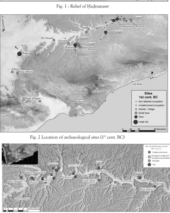
simultaneous development of a new pottery tradition, of hydraulic systems and the growth of many sites – such as Shabwa, Raybûn, Makaynûn, Bi’r Hamad, Jûja and Mashgha (fig. 2) – does not seem to have to do but with chance and could be link with migration or external contacts6.
This ancient wâdî Hadramawt culture disappeared between the 8th and 7th cent. BC, then
replaced by the so-called « classical Hadramawt culture »7. Many aspects of the Sabaean culture
were introduced on most of the sites in Hadramawt: use of Sabaean language, worship of Sabaean gods such as Almaqah and dhât-Himyam. In inner Hadramawt, a regular settlement pattern developed at that time. The map of the populated places for the 3rd cent. BC. (fig. 3)
shows a town together with one or several temples located at every confluence of the Masîla with its major tributaries. The steeply sided setting of the wâdî Masîla into the silt plain made it impossible for local population to use its water to supply the irrigation systems. Indeed the
1 Centre d’anthropologie, École des Hautes Études en Sciences Sociales, 39 allées Jules Guesde, 31 000 Toulouse (France). 2 J. McCorriston, M. Harrower, E. Oches & ‘A. Bin ‘Aqil, 2005. « Foraging economies and population in the middle Holocene Highlands of Southern Yemen », Proceedings of the Seminar for Arabian Studies 35, pp. 143-154.
3 A. Benoist, O. Lavigne, M. Mouton & J. Schiettecatte (forthcoming). « Chronologie et évolution de l’architecture à Makaynûn », Proceedings of the Seminar for Arabian Studies 37.
4 A. V. Sedov, 1997. « Die archäologischen Denkmäler von Raybûn im unteren Wâdî Dau‘an (Hadramaut) », Mare Erythraeum 1, pp. 31-106.
5 A. V. Sedov, 1996. « On the Origin of the agricultural settlements in Hadramawt ». In Robin Ch. J. & Gajda I. (éds), Arabia antiqua, Early Origins of South Arabian States, Serie Orientale Roma LXX, 1, Rome, IsMEO, p. 86.
6 A. V. Sedov, 1997, « Die archäologischen Denkmäler…„ p. 45.
water supply for cultivation did not came from the main wâdî but rather from the diverting of floods drained out of tributary valleys. Communities were settled where the tributaries open out so that they could control its access, handle the floods and develop an irrigation system that stretched over both the central valley and upstream from the tributary mouth. Each of these archaeological sites was the centre of a cultivated area. The growth of these various settlement depends partly – not to say mainly – on the size of the drainage basin watering the cultivated land.
Thus, the settlement pattern in the valley depended on environmental constraints that in turn affected the urban growth in this region: the growth of each site was quickly limited by the agricultural capacity that the diverted floods made possible. The genuine towns were therefore extremely rare and most of the settlements located at the mouth of tributaries resembled rather villages than towns. Moreover, according to the map of the region, each cultivated area allowed only a single major settlement. Due to their limited capacities, the runoffs ensured very seldom an important density of the settlement network. The rare intermediate facilities between the main sites were but farms or hamlets exploiting the land.
In the western part of the Hadramawt valley, the settlement pattern differs from the one above-mentioned. This is partly due to a different landscape and to the greater width of the Hadramawt valley. According to the available data (fig. 2), the seldom urban settlements did not expand at the mouth of tributaries of the wâdî Hadramawt but rather on the middle/lower reaches of the main tributaries. There, flood was easier to divert and control. Set back from the main valley, none of these sites display sign of an influence from a centralized power. These towns do not seem having properly integrated the political life of the kingdoms located around the Ramlat as-Sab‘atayn however, at least until the end of the 1st mill. BC. Political conflict and power struggle certainly took place among the inhabitants of these sites or between neighbouring settlements. But that no supra-communal intervention is mentioned before the end of the 1st mill. BC says a lot about the stability of political territories and land-holdings. It
seems possible to assume that their extension mainly – not to say only – depended on technical capacities and on the time required to reach the fields.
Many sites located between Shabwa and Makaynûn area offered a defended fallback position for inhabitants of the area. Nevertheless, these defensive systems were seldom able to endure a siege. They were most probably designed to ensure the security of people against facing with raids or neighbourhood disputes. During the 1st mill. BC, the kingdoms bordering
Hadramawt do not seem to have felt drawn to the Inner valley; the Hadrami king himself did not leave a mark there. This region does not appear as a potential target before the end of the 1st mill. BC. Its agricultural production capacities cannot feed more than small communities.
As far as we know, no mineral resources have been exploited. These unassuming communities acted as a weak magnet on their neighbours and their geographical enclosing probably did not encourage these neighbours to raid them except maybe for nomadic tribes from the plateau. There would be no need for these settlements to get strong walls in view of improbable foes before the end of the 1st mill. BC at least.
Until the end of the 1st mill. BC, the Hadramawt entity is defined by a cultural unity
based on common language, worships and material culture. In spite of this unity, inner Hadramawt did not have integrated the political life of the Hadramawt kingdom. This kingdom was centred on western Hadramawt (Shabwa, al-Binâ’, Naqb al-Hagar), on the fringe of the Ramlat as-Sab‘atayn (fig. 2). About the 2nd and 1st cent. BC, several conflicts set Hadramawt and
them went obviously through dramatic events (the fire at Raybûn for example) ; others declined quickly without any historical explanation to be put forward such as Makaynûn.
On the opposite, the desert and coastal edges of Hadramawt merged quickly into a territorial entity governed from a single capital, Shabwa (fig. 2). Since the 7th cent. BC, the
settlements in the wâdî Jirdân constituted a possible resting place on the track from Shabwa to Qatabân kingdom. From the 4th-3rd cent. BC onwards, southern and coastal towns made their
appearance. From this period at the latest, Hadramis settled on the Omani shore, at Khawr Rûrî; the Hadrami king made a kabîr – go-between of the king – responsible of the building of fortifications at Naqb al-Hajar, a stopping place between the shore and the Hadrami capital city. Moreover, a settlement is known at Shihr-East8, an inhabited mooring place. These facts could
be explained by king’s will to control new maritime commercial routes that developed at that time with an increase of coastal shipping practice. Frankincense from Zufâr may have been transported by coastal shipping and then by land along the wâdî Mayfa‘a, via the new grown city of Naqb al-Hajar, up to the capital Shabwa and later towards the north by the caravan road.
During the 1st cent. BC, the port of Bi’r ‘Alî was founded and the pass of al-Binâ’ fortified. These facts emphasize the primacy of the maritime route for incense handling from the growing areas of Zufâr and Mahra to Shabwa. By the middle of the 1st cent. AD, while Khawr Rûrî was rebuilt in its entirety and Bi’r ‘Alî initiated a quick growth, the maritime trade definitely overtook the caravan trade.
Therefore, contrary to inner sites, most of the Hadrami settlements of the desert edge and coastal plain of the kingdom were soon integrated in a territory that the king controlled directly, because of their strategic function near the border of the Qatabânian kingdom and their importance on the trade routes. At the beginning of the Christian era, the power of the king significantly increased, thanks to the collapse of the Qatabânian kingdom. The monarch was addressed as mukarrib in the inscriptions, a title taken by the king when its kingdom had become the most powerful of South-Arabian kingdoms. He extended its control over the aromatics’ trade. It is only at that very moment that we get clues of the integration of inner Hadramawt into this political entity.
8 A. Rougeulle, 1999. « Coastal settlements in southern Yemen: the 1996-1997 survey expeditions on the Hadramawt and Mahra coasts », Proceedings of the Seminar for Arabian Studies 29, pp. 123-135.
Fig. 1 : Relief of Hadramawt
Fig. 3: Oriental Hadramawt: location of archaeological sites (3rd cent. BC) Fig. 2 Location of archaeological sites (1st cent. BC)
![[PDF] Cours Base de Données Access | Télécharger PDF](data:image/gif;base64,R0lGODlhAQABAIAAAP///wAAACH5BAEAAAAALAAAAAABAAEAAAICRAEAOw==)