CITY IN TRANSITION:
Aspects of Industrial and Urban Development in Koahsiung ,Taiwan by
Liang-Ying Chang B.Arch, Tunghai University
Taichung, ROC June, 1986
SUBMITTED TO THE DEPARTMENT OF ARCHITECTURE
IN PARTIAL FULFILLMENT OF THE REQUIREMENT OF THE DEGREE MASTER OF SCIENCE IN ARCHITECTURE STUDIES
AT THE
MASSACHUSETTS INSTITUTE OF TECHNOLOGY JUNE 1990
@ Liang-Ying Chang 1990. All rights reserved. The author hereby grants to M.I.T. permission
to reproduce and to distribute copies of this thesis document in whole or in part.
Signature of the Author -4
Liang-Ying
'Chand'
Depa4ment of Ac~itecture 11 May 1990School of
J
Peter Droege
Architecture and Planning Thesis Supervisor
Accepted by
Chairman, Departmen
Julian Beinart Committee on Graduate Students M'ASSACHUSFTTS INSTITUTE OF TEC ',II 1 iy M AY 3 0 1990 LIBRARIES 4.% - I -Certified by Visiting Lecturer,
'4
CITY IN TRANSITION:
Aspects of Industrial and Urban Development in Koahsiung, Taiwan by
Liang-Ying Chang
Submitted to the Department of Architecture on May 11,1990 in partial fulfillment of the requirements for the Degree of
Master of Science in Architecture Studies
ABSTRACT
Koahsiung, the largest industrial harbor city in Taiwan, is in a stage of transition, characterized by the presence of urban evolution
after the economic upswing brought about by industry in the last few decades. The confused relationship between the people and their environment provides evidence of this transition. Two issues concerning the urban environment of Koahsiung at present are: first, the centeral urban areas faces growth pressures because of the strengthening of the city function; and second, industries in the urban area create spatial dilemmas in efforts to address questions of urban growth. Undesirable form of mixed land use and degradation of the environment are obvious problems. Understanding their origin and exploring opportunities for solving them will mean investigating closely the relationship between the industry and urban development. Restructuring the role of industry in the urban area and improving the use of urban land are challenges in facing the conflict of urban industry and human environment.
This thesis also attempts to address the burning issues of informal sector accommodation in mixed use areas.
Thesis Supervisor: Peter Droege
In front of my house is a river, And in the back a slope. The slope is flower-covered,
Red as if on fire.
In the river are white geese. The geese play with the waves.
Playing in the water the geese are happy. They lift their heads and sing a song.
TABLE OF CONTENTS
INTRODUCTION 6
CHAPTER I URBAN BACKGROUND OF KOAHSIUNG
1.1 GENERAL DESCRIPTION 11
1.2 FIVE URBAN STAGES OF KOAHSIUNG 13
1.3 PLANNING OF THE INDUSTRIAL AREA DURING AND AFTER THE
PERIOD OF JAPANESE RULE 20
CHAPTER 11 THE INDUSTRIAL BELT: Koahsiung's Inner Frontier
2.1 CURRENT ISSUES OF URBAN GROWTH IN KOAHSIUNG CITY 23
2.1.1 Growth Imbalance 24
2.1.2 Urban Industries 27
2.2 THE INNER-CITY MIXED-USE DILEMMA 39
2.2.1 Degradation of the Physical Environment 42 2.2.2 Degradation of the Psychological Environment 46' 2.3 SPATIO-FUNCTIONAL RELATIONSHIPS BETWEEN INDUSTRIES
AND RESIDENTIAL AREAS 47
2.3.1 In Separate Territories 48
2.3.2 Within One Territory 50
2.4 CHALLENGES 54
2.4.1 Removing the Industries 54
2.4.2 Urban Land Use Conflicts 57
CHAPTER III AUO-ZUEDI SITE STUDY: A Detailed Look
3.1 SITE FEATURES 59
3.2 INDUSTRIES 69
3.2.2 Low-Polluting Industries 73
3.2.3 Non-Polluting Industry 75
3.3 THE PHYSICAL AS DETERMINANT OF THE RELATIONSHIP
BETWEEN INDUSTRY AND RESIDENTIAL AREAS 77
3.3.1 Mixed-Use Building 77
3.3.2 Communities 84
3.3.3 Urban Spatial Analysis 86
CHAPTER IV ASPECT OF SPATIAL MANAGEMENT
4.1 RECONFIGURATION OF INDUSTRIAL DEVELOPMENT 89
4.1.1 Recommendation 1 91
4.1.2 Recommendation 2 93
4.1.3 Recommendation 3 94
4.2 MANAGING LAND RESOURCES 97
4.2.1 Recommendation 1 100
4.2.2 Recommendation 2 101'
4.3 CONCLUSION: A HUMAN VISION FOR THE INDUSTRIAL BELT 103
4.3.1 Philosophy 103
4.3.2 Vision : A Symbiotic City 104
TABLES 111
BIBLIOGRAPHY 115
(All the photos and drawings are done by the author, except those otherwise specified.)
INTRODUCTION
Political changes transformed Taiwan's economy from a colonial to an autonomous system after the recovery from Japanese rule in 1945.1 The low-wage labor production system and the international commercial boom led to an economic upswing in Koahsiung before 1970. After 1970, world-wide economic growth began to slow down, while in Taiwan the pressure for growth in urban wages increased. At the same time, it became difficult to employ and accommdate the young laborers from the countryside. Taiwan's production system began to be restructured from labor-intensive to technology-based,2 which influenced the
spatial redistribution of production in the main cities. The production system began to include informal systems in addition to the already existing formal systems in order to increase its ability to compete. Medium- and small-scale industries became an important part of the system and significantly influenced the spatial structure of the city.
Immigrants from other cities in southern Taiwan settled the urban fringe of the area during the period of Japanese rule and transformed it into a metropolitan area in the period after the Second World War.3 In 1The function of the city in Taiwan set by the Japanese is according to the economic demand or political strategy to the world. See Huang, She-Mang The Paradiam of City Planning in Taiwan in the Japanese Rule Period ,1987, Graduate School of Civil Engineering Department of Taiwan National University. p.65.
2 See Sun, Yi-Chong "Regional Planning Policy of Taiwan," Taiwan: A Radical Quarterly in
Social Study. Voll: 2,3. 1988, p.62.
3 See Table 1: Metropolitan population distribution and growth. Chang, Chung-Ming,
"Study of Residential Spatial Structure in Koahsiung Metropolitan Area," Graduate School of Urban Planning in Jung-Shing Univ. Thesis, 1987.
the regional planning of southern Taiwan in 1974, the national government developed industrial zones in towns of the metropolitan area in an attempt to rationally distribute the population, places of production, and resources of Koahsiung city (Fig.1).1 Although the urban population is spread across the rest of the metropolitan areas for work or residency, the typical urban consumption patterns of Taiwan are such that the city has retained its function as a center of consumption and services for the metropolitan area.2 In addition, through the restructuring of the production system of the city, the business services and commercial activities are gradually becoming dominant.3
These transformations will disrupt the population structure and change how people see their environment, as well as what they expect from it. All these factors have acted on the physical urban environment of today. The seeming chaos in the urban areas of Koahsiung reflects the interaction of the logic of capital and the urban spatial structure.
A large amount of medium- and small-scale industries were introduced into the city in the last two decades. These smaller industries, together with the original large-scale industries which had been at the urban perimeter, formed "industrial frontiers," now imbedded deep inside the growing metropolis. The conflict between the
1See Sun, Yi-Chong, "Regional Planning Policy of Taiwan," Taiwan: A Radical Quarterly in
Social Studv. Voll: 2,3, 1988.
2 See Report for Kohsiung Auo-Zuedi Sub-city Center Development. Graduate School of Civil Engineering Department of Taiwan National University, Introductionl-1.
3 See table 2: Population of the productivities from 1971 to 1981, Investigation of Industry and business in Koahsiung, 1981.
'-7 / -- . -- --- .--- DA-LEOW City of Koahsiung M'LIN-YEN - City core source:
Evaluation of Industrial Development & Location iri
Koahsiung
"frontiers" and "normal" urban development actually reflects the conflict between different social statuses.1 A well-managed physical
environment must be based on a social and economic vision of a balanced, more harmonious city.
Since the industrial belt, the "inner frontier," is home to the elements of Koahsiung's society, a careful securing and redistribution of spatial resources must anticipate Koahsiung's economic and social evolution. The urban spatial structure has to be reformed and must reach a state of balance between the frontier formed by production systems and the residential areas.
This thesis provides at its outset an overview of the historical and spatial relationship between industrial growth and urban planning since the period of Japanese rule. After that, I will look at the industrial frontier in the urban area today and focus on the issues of industry, because its occupation of the central urban area has led to a face-to-face, partially symbiotic conflict with the people's living environment, and has, in some sense, shifted the growth of the central urban area. Finally, I will choose the next potential site for urban development and identity the issues worth studying by listing and analyzing the problems. I will then suggest an approach to solving the problems while satisfying the sophisticated interrelationships in the urban
1 " ..The chaos in the urban context shows evidence that it is the spatial structure controlled
by the market (or logic of capital). This is because urban space is determined by the social productivities, which are the result of different social statue conflict...." Quote from interview with Manuel Castells, Taiwan: A Radical Quarterly in Social Study., 1988, Preface.
evolution of industry and human living environments. At the end of the thesis, an image for the future of the potential site is proposed in a collage description, following an analysis of the problems.
Spatial arrangement is also important in this thesis, since the disorder in the relationships between single units and the urban scale is the main concern and the basis for the proposed solutions. The original idea behind the analysis of the spatial relationships is from John Habraken in his Transformation of the Site, which tries to explain the urban phenomenon through analyzing the interaction of forces involved in the formation of space and form. However, we do not exactly follow the steps of his process of analysis, because the interactions within the two urban contexts are different in their economic and cultural backgrounds.
CHAPTER I
URBAN DEVELOPMENT BACKGROUND
1.1 GENERAL DESCRIPTION
Koahsiung originated as a small village on the Chi-Ging island, which was located outside Koahsiung Harbor. The city experienced different political changes during the Dutch rule, the Ming Dynasty, the Ching Dynasty and the period of Japanese rule. When we look at the map of the city, we can see an obvious city core defined by the railway--the central urban area of Koahsiung today (Fig.1). The city planning after the recovery of Koahsiung at the end of World War II is based on the planning in the period of Japanese rule. Most of the industrial locations of the city today are the same as those used in the period of Japanese rule .
The industrial development in Koahsiung started in 1900 with the pineapple industry, which was the first basic production industry run
by the Japanese in the city. The products of industry in the city were
agricultural at the early stage, followed by iron production and non-metal mining production. After the start of the Second World War, the Japanese began to build heavy industries in the southern area of the city core. In the period after recovery from Japanese rule and before
chemical production,1 turned industry into a vital economic support for
the southern area of Taiwan. After 1970, global recession lead to the change of Taiwan's economic production structure. Medium- and small-scale industries began to decentralize the centers of production. The location of the industries in the city after the period of Japanese rule was also greatly affected by the subsequent economic changes.
There are two facts which affect the industrial development of Koahsiung: one is the construction of the harbor, and the other is the construction of the railway. In the period of Japanese rule, the harbor was used mainly to export the products of southern Taiwan to mainland China, Japan, and other countries in Asia, while the railroad was used to transport the products to the inner cities. Another result of the harbor's construction was expanded urban development. The plans for the harbor were produced simultaneously with the planning of the urban area. The location of the industries either followed the expansion of the city edge, which was directly affected by the changes of the harbor construction, or followed the locations of railway stations. The forming of the growth pattern of Taiwan's city is strongly related to the location of railway stations. The area in front of a station was used as a commercial area and the back side of the station was developed into an industrial area.2 After the recovery, the government started to
make strategic industrial developments in some specific areas, such as 1 See Cheng, Geing-Hwa, Simulation of the Koahsiung industrial development system-- Use DRAM model for Example, Chung Shing Univ. Graduate school of urban planning thesis,
1986, p.75.
2 Wu, Ching-Sheing, Research of City Planning and Growth of Taiwan in the Period of Japanese Rule, 1988.
the Nan-Zue export processing industrial area and the Show-Gong industrial area (see Chapter 2.1.1 p.24). The harbor increased the potential and ability of Koahsiung's industrial development to go forward and to become an international harbor city.
1.2 FIVE URBAN STAGES
According to the categorization by Ching Sheng Wu in Research of City Planning and Growth of Taiwan in the Period of Japanese Rule, the city planning of Koahsiung in the period of Japanese rule can be divided into four stages:
The First Stage - from June, 1895 to April, 1908, which dates from the beginning of the Japanese occupancy to the announcement of the first revised urban plan of Ta-Gow (the original name of Koahsiung) (Fig.2a).
The Second Stage - from May, 1908 to February, 1921, which designates the period from the announcement of the first revised urban
plan to the announcement of the first urban expansion plan (Fig.2b). The Third Stage - from February, 1921 to October, 1932, which
marks the time from the announcement and execution of the first urban expansion plan to the announcement of the Metro-Kouahsiung urban plan (Fig.2c).
The Fourth Stage - from October, 1932 to August, 1945, which delineates the period from the announcement of the first Metro-Koahsiung urban plan to the end of the period of Japanese rule (end of the Second World War). (Fig.2d)
After recovery - From August,1945, which dates from the end of the period of Japanese rule till November, 1945 - the first reannouncement of the Koahsiung urban plan by the new government.(Fig.2e)
The reason for applying this categorization is that there are clear distinctions between the four stages, in which each urban plan has greatly affected the expansion of the city. Thus we can observe the sequence of the urban evolution from the changing of the location of the urban and industrial areas of Koahsiung.
THE FIRST STAGE (1895.6 - 1908.4) Main industry: Sugar, pineapple TO INNER CITY/ 4. TO FONG-SHENG GOVERNOR INDUSTRIAL LOCATION Fig.2a 15
THE SECOND STAGE (1908.5 - 1921.2)
Main industry:
Iron for shipbuilding, alchohol, cement, fertilizers RAILROAD GOVERNOR INDUSTRIAL LOCATION Fig.2b
T,
THE THIRD
(1921.2 - 1
STAGE 932.10)
Main industry
Foods, cans, soap, ice agricultural implements, automobil production RAILWAY STATION INDUSTRIAL LOCATION Fig.2c
(1)
THE FOURTH STAGE (1932.10 - 1945.8)
Main industry
Mechanical production, aluminium, shipbuilding, oil refinery, steel-press,
SHO-MOUNTAIN
EXISTING URBAN AREA
g
PLANNING URBAN AREA INDUSTRIAL LOCATIONAFTER RECOVERY
(1945.8 - 1945.11)
sm---- CITY EDGE
I
AFREA OF THE PLAN INFig.2e
1.3 PLANNING OF THE INDUSTRIAL AREA IN THE PERIODS DURING AND
AFTER JAPANESE RULE
The distribution of the industries in the urban areas followed different principles in the four stages of the period of Japanese rule. In the early stages, the configuration of the industrial areas followed the existing land use rather than changing and replanning it.1 Later, the planning of the industrial areas was more strategic in order to match the Japanese offensive on South Asia in the Second World War. Chen-Gen and Nai-Wei were two main heavy industrial areas planned in the later stage of Japanese rule. The demand for military industry formed the radiating street pattern (unlike the gridiron street pattern within the central urban area) in order to achieve efficiency in the transportation of products. This industrial area, along with the railway, formed the south edge of the city core. In the urban planning of the fourth stage, "unzoned districts" were set up on the edge of industrial areas for the mixed use of the industrial and residential or commercial lands (Fig.3). 2
The planning and land use within the city core after the recovery almost follows in the footsteps of that of the period of Japanese rule. The large-scale industrial developments brought about the economic 1 The Japanese government started urban planning in Taiwan in 1932 for the first
announcement of the planning of Koahsiung. Before that, the urban planning was only a
partial readjustment plan of the urban area with a rough zoning area according to the existing use.
Wu, Ching Sheing, Research of City Planning and Growth of Taiwan in the Japanese Rule
Period , p.113.
source:
I, ,
i/ r
'4V Wu, Ching Sheing Research of City Planning and Growth of Taiwan in the Japanese Rule Period.
114 -.. /V ....RESIDENTIAL AREA INDUSTRIAL AREA UNZONED AREA-COMMERCIAL AREA
Fig.3 Land Use of the late Period of Japanese Rule 21
development of the city and also accelerated the urbanization of the city. The build-up of the Nan-Zue high-tech industrial processing district in 1973, the construction of the second harbor in 1975, and the development of coastal industrial districts in 1976 were strategic developments in those areas. The other industrial locations which were set up within the urban area followed the formation of fragmented industries in a leap-frogging pattern. These areas are concentrated along the sides of freeways and on the edge of the central urban area. After the redistribution of the centers of industrial production, the small, family-run industries spread into different zoning areas, forming an invisible frontier within the central urban core.
CHAPTER II.
THE INDUSTRIAL BELT : Koahsiung's Inner Frontier
2.2.1 CURRENT ISSUES OF URBAN GROWTH IN KOAHSIUNG
When the city faces the pressures of urban growth, the industries in the urban area are challenged and their existence reevaluated in the urban context. The strengthening of employment and information services led to the continuing growth of the population of Koahsiung. The growth of the city stimulated urban redevelopment, but a dilemma was caused by the dual nature of economic functions and the degradation of the environment around industries. To consider the issue of urban development in Koahsiung, one must first consider the impact of the industries in the urban area, since the conflict of the industries and people in the urban area is accentuated by the urban growth and can
no longer be ignored.
The population of Koahsiung grew from 662,202 in 1966 to 1,302,849 in 1985. Koahsiung harbor provides a great opportunity for the growth of business and transportation services and for exploring the potential of the industries in the city. The growth of the city's population can be revealing for trying to understand the growth of the city itself.
In the period between 1967 to 1970, the population growth of the urban area was 6.4%. From 1972 to 1976, the growth rate was 4.3%. Then it decreased to 3.5% from 1976 to 1980. Until 1985, the growth rate was
2.01%. This phenomenon shows that the population growth in the urban area reached a saturation point during the urbanization process and lead to the flow of population out of the city. There are three types of population growth patterns within the urban area. In the first type, the ratio of population of the area to the metropolitan area is continuing to go up. Sang-Ming Chu,1 Cheng-Gen Chu, and Ling-Yar Chu are the main
areas of this type (Fig.4). In the second type, the rate of changes in the area is going from decreasing to increasing. Nan-Zue Chu and Shauw-Gung Chu are the main areas of this type. In the third type, the ratio of the population of the area compared to the metropolitan area is continuing to decrease, as in Cheng-Ging Chu, Yeng-Cheng Chu, and Shing-Shin Chu. These areas were developed in the early years of the period of Japanese rule.2 We can observe that the population started to move toward the south and north of the city core as a result of expanding urban development.
2.1.1 GROWTH IMBALANCE
Pre- and post-recovery development divided the city into three parts. Nan Zue Chu, a large-scale oil refinery industry with its employee community, formed in the north of Koahsiung City. The construction of the Show-Gong industrial zone in 1979 and the linking of the harbor and airport concentrated the urban activities around the south where much of the recent urban development had occurred (Fig.5). To the north of
1 "Chu" designates an administrative zoning unit.
2 Chang, Chung-Ming, Study of Residential Spatial Structure in Koahsiuna Metropolitan
HU h SANG-MING CHU -LIN-VARD CHU SHING-SHIN CHUt CHENG-GING CHUi YENG-CHENG CHU CHENG-GEN CHU Continuing decrease From decrease to increas Continuing increase
( Chu: Administrative zoning unit)
Fig.4 Transformation of Population in Urban Area 25
2
NAN-ZUE EXPORT INDUSTRIAL PRODUCTION PROCESSING 3 DISTRICT
NEW HARRnd
IAUA
the city core, the area crossed by the railway and the Gen-Eai River is bearing the pressures of city growth but has not been selected to play a role in the urban development ( Fig.5).
There is a growing imbalance between growth in employment and growth in housing supply.1 The centralization toward the southern area
of the city has aggravated the traffic volume and boosted demand in the residential area. The congestion in the city core reveals the strong demand for residential space.2 Redeveloping the area to provide
residency and employment opportunity between the city core and the northern area could balance the regional development of the city and intensify the urban resources as a way of inducing the restructuring of the urban environment.
2.1.2 URBAN INDUSTRIES
The large-scale industries are distributed in several areas. They have
formed their own borders in the areas around the factories after being there for a long period of time. The cement industry is close to the Sho Mountain for easy access to raw materials and for convenience of transportation. Taiwan Aluminium Industry and Taiwan Plastic Industry
1 See Table 3: Comparison of the residential and employment of northern and southern area
of Koahsiung. Total residential / total employees= K ( average residential area per person). The total residential area demand for the employee in southern area is 463641 ha / Existing residential area 302652 ha.
In the northern area Demand 363630 ha / Existing 302855 ha.
The total residential area should be increased in the other areas to feed the need of employees in the southern area. Chang, Jung-Ming, Study of Residential spatial structure of
Koahsiung Metropolitan Area,1987.
2 See Report for Kohsiuna Auo-Zuedi Sub-city Center Development, Graduate School of Civil Engineering, Taiwan University, 1987, Introductionl-1.
2 GU-SHENG NEI-WEl/ INDUSTRIAL AREA -Cement inc Taiwan al Taiwan ol G-ZU CORRIDOR --Thermoelectric plants IKoahsiung sulfatesalt->ychernical industry. uminium i astic indu
China steel indus'try SMALL-SCALE INDUSTRIAL LOCATION
China shipbuilding Fig.6 Distribution of Industry in
industry the City
are both located within the Chen-Gen Chu close to the local railway. China Oil Refinery Industry established its headquarters in the northern part of the city. The shipbuilding and steel industries are located in relation to the harbor and the airport. The small-scale industries are located around the peremeter of the city core, perticularly in the area between the railway and the expresswar to the north and along the railway at the southern edge of city core (Fig.6).
Most large-scale industries belong to the public sector. Both of the industrial areas are in themselves well-planned from a land use point of view. Because the big industries offer ample employment opportunity and attract a large population from the surrounding community, they have gradually formed an industrial neighborhood complex. 1
The categorization of the industrial locations within the urban area is defined in the report, Evaluation of the Industrial Development and Choice of Location, by the City Planning Department of Koahsiung, is shown in Figure 6.
Cheing-Gen:
This area covers part of the city core and most of the harbor and hinterland. This is the most seriously polluted area in of all of the industrial areas, because most of the large-scale heavy-polluting 1 The classification of industrial scale is according to the no. of employees: Largest scale: >500 persons, Oil refinery & coal production industry.
Middle scale: 100-499 persons, Metal industry (110, 225 persons)
Small scale: 0-99 persons. Transportation tool repair industries, pAper & print industry, cloth & spin industries, leather & fur industries (25 persons).
See The Republic of China Labor Force Statistics Monthly Journal, 1979, 1982, 1983.
Fig.7. Industries and housing in the Cheng-Gen industrial area
Fig.8. New housing developments in Cheng-Gen Chu
industries in Koahsiung are gathered together in this area. Since this industrial location is the closest to the city center, and since the housing demand of the central urban area is great, the industries have come closer to people's everyday lives (Fig.7).
There is an industrial processing export district, located in the harbor area, for the production of electronics and appliances. The main large-scale factories in this area belong to the Taiwan plastic industry, the Taiwan aluminium industry, the thermoelectric plants, the Taiwan machine industry, and the Koahsiung sulfatesalt-chemical industry. Those industries are severe air and water pollution sources, and they endanger the lives of people in the surrounding residential areas and the lives of their own employees.
In recent years, land prices in this area have risen considerably compared to the other industrial areas, since its location and the street pattern offer a good connection to the city center.1 Booms in the urban market have lifted the land price of the area inside the original urban edge (the railway). This is especially true in the residential area facing the main street of the city, Chong-Sheng Third Road. The southern area, which is zoned for industrial use, is used for industrial transportation, storage and agriculture. Some of it has been converted to residential use because of the expansion of the city. The polluting factories are all concentrated in the northern area inside the railroad. A large amount of private development (such as high-rise buildings) 1 The statement is according to personal observation of the area: high-rise and luxury housing projects are built on the land and replace the originally vacant land.
takes place in the vacant land adjacent to the factories and is offered at a high price. The residential towers stands in close to the factories indicating the strong demand for urban land (Figs.7,8). The dangers of the chemical factories haunt the neighborhood. (Fig.7)
The percentage of the industrial area developed in the whole industrial zone is 43.3%. The percentage of public land in the industrial area is
35.3%. The open space for parks is only 0.7%. The other public lands are
roads, water land and storage land. The water land, used mainly by the industries, is seriously polluted.
Ming-Zu Road Corridor:
This area is located just outside of the heart of the city. It is a transition area between the high-density city core and the edge of the city. The area is bounded on one side by the upper stream of the Jen-Eai River and on the other side by Ming-Zu Road, which is one of the main freeways connecting the city to other cities (Fig.9a). Convenient transportation and the large amount of vacant land beside the river make it an ideal place for the illegal factories to gather (Fig.9b). The chaotic image of the area reflects the rapidly changing character of the location and offers an indication of the second expansion of the city since the recovery.
52% of the factories in the Ming-Zu Corridor are illegal. In this area
most of the people live and work in the same place; the living quality of the area is poor and the pollution of the factories is out of control. The main industries in the area are metal production and transportation
amk
Fig.9a Ming-zu corridor
Fig.9b Factories beside the Gen-Eai River
Fig.10a Street View of the district beside the Sho Mountain
Fig.10b View of Sho Mountain and Gu-Sheng Chu
tool repair. There is serious pollution in the natural resource there--the water land. The river is one of there--the main resources of open space and
makes a view of the city possible.
Some of the factories are planning to move out of the city and into the industrial zone because the industries are restricted from expanding in this area. The area still has a serious problem in mixed-land use of
small-scale industries in residential areas.
Gu-Sheng Chu in Nai-Wai district:
Gu-sheng Chu has been developed since the second stage of the period of Japanese rule. Mechanical production and the cement industry are the main industries in the area. The area is connected to the old city commercial center, Yen Cheng Chu, and the political center in the Koahsiung area before the period of Japanese rule, Zuo-Ying Chu.1 There is also a string area located between Sho Mountain and the railway (Fig.10a). Sho Mountain is the main source of raw material for the cement industry (Fig.10b). The decaying of Yeng-Cheng Chu and Zuo-Ying Chu prevented further development of the area.2
The lands surrounding Nei-Wai Lake on the eastern side of the railroad (opposite Gu-Sheng Chu) are now vacant and filled with illegal
1 Zuo-Ying Chu has been a political center since the Ching Dynasty.
2 Yeng-Cheng Chu used to be the commercial center in the period of Japanese rule, but the area began to decay while the commercial center was moving toward the east.
Zuo-Ying Chu has become a concentrated military post because of its strategic location on the coast.
factories. The lake is meant to offer an open space for the city, but now the water is tainted by the industries on the land (Fig.11a).
The unplanned nature of the Nei-Wei area not only impeded the extension of city development to the Gu-Sheng Chu, but turned one of the largest green spaces of the city into wasteland. Nei-Wei Chu was planned as an industrial zone. It extended across the Jen-Eai River, then stretched to the west of the river, forming a complete industrial belt with the cement industry (Fig.11b). The industrial development rate for industrial land here is 34.2%, the lowest in all of the industrial areas of Koahsiung city. A new plan for the industries is essential for further development of the Gu-Sheng Chu, and for protection of natural resources in the Nei-Wai district.
Neng-Zue:
This area is formed mainly by the oil refinery industry with its community of employees, and also by the cement industry. The separation between the industries and people's living environments is much better planned than in the other industrial areas, but the pollution caused by the oil refinery factories seriously damages the air quality of the area.
Shauw-Gung Chu:
This entire area is an industrial site developed by the government. The shipbuilding and steel industries are the main ones there. Within the area is also a community for the employees of both industries. The two industries are strategic ones and have better control over their
Fig.11a Polluted water of Nei-Wei Lake
Fig.11b View from Nei-Wei Lake to Gu-Sheng Chu 37
industrial pollution than other industries. Therefore, they will not be considered for relocation out of the city in the near future. As the site is near the harbor and offers a good industrial environment, the feasibility of changing the land use of the area is low.
The large industries and the enviornmental protection groups have argued about relocation for a long time. It is also a dilemma for industrial development on Koahsiung City, but there are other factors which outweigh the enviornmental concerns. Firstly, almost all the large-scale industries are located in complete and well-planned industrial sites. They have generally formed their own frontiers away from the central urban area and have not yet caused a face-to-face confrontation with the urban development of the city. Secondly, The removal of the large-scale industries involves problems mainly based on economic concerns1 which are not the focus of this thesis.
The small-scale industries, which spontaneously spread in high- and low-density urban areas, have a strong influence on the current urban development of Koahsiung. Because of their small scale and the fact that most of them are informal and are combined with people's living spaces, the industries are a strong presence in the central urban areas. The most common process of evolution of the small-scale industries in the urban context involves an aggregation of points to a plane, then the gradual erosion of the surrounding area, and finally the formation of the frontier (Fig.12). We will observe the formation of the frontier and 1These considerations focus on the cost and return analysis about the factories' construction and facility costs, and the acquisition of large pieces of land for factories.
the interaction of different industries with people, using this as a basis to outline the combination of industrial production, people, and the central city.
Fig.12 2.2. THE INNER-CITY MIXED-USE DILEMMA
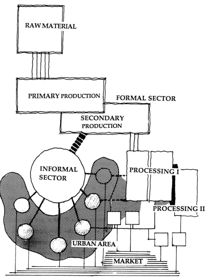
Small-scale industries have always played a key role in the urbanization of Koahsiung and are the main form of informal production. Since the period of Japanese rule, they have supported the city economically; physically, they have formed the visible perimeter of the city, an urban edge of pollution and cheap land. The division of the industrial production structure determines the distribution of small-scale industries in the urban spatial structure. The small-small-scale factories are scattered over the urban area as a result of the restructuring and fragmentation of the systems of production and the loosening of industrial regulations. These industries need the least labor but can satisfy the demand for variety in production. However, they have the least flexibility in adapting to economic or physical changes. The home factories are the most basic units in the whole production division structure. In the flowchart of industrial productivity--the production process from raw materials to the market--the small industries are the active structure mediating between the upstream and downstream industries (Fig.13). Most of the private industries fall into the catagory of processing. Some of the private industries initially grew around the main industries of the area, which process raw materials to a formed state to be further
RAW MATERIAL
PRIMARY PRODUCTION FORMAL SECTOR
SECONDARY PRODUCTON SPROCESSING I -',' .. CE SN UANAREA
processed. The conventional industries still give the cost of production the highest priority when considering the location of the factories.1 When the transportation situation was improved, the cost of land became the main factor in choosing factory locations for the private industries. Sixty-five percent of the industries are illegal.2 Low and middle income families involved in the informal center of production settle in the marginal land of the city or use their houses as work space to reduce the cost of production. In the analysis of the previous chapter, we saw how the movement of industries interacted with urban development. The economic relationship between the industries and urban spatial structures will continue to be played out when the industries start relocating within the urban area. Understanding the ecological process of the interaction of industrial productivity with the changing urban demand can provide a basis for decisions about the current urban development dilemma.
Anticipated change within the inner urban industrial territories raises the necessity of a new relationship between people and industry. Unplanned mixed land use in the Koahsiung industrial belt has resulted in the decay of both the industrial and human living environments. As Koahsiung requires more land to relieve the growing pressure within the urban area, the conflicts become more visible. The industrial inner land provides the physical evidence for studying the relationships
1 Storper, Michael, "Toward a structural theory of industrial location," Industrial Location & Regional Systems. Some of the factors involved with the production cost no longer
determine the conventional industries' locations, but in developing countries like Taiwan, the cost of production still is the most important factor in setting the industrial location. 2 See Table 4: No. of illegal factories in Koahsiung.
between small scale industrial production, people, and urban development. Then can come the replanning of the area as urban resources become accessible.
Some problems were raised in the urban area by the inner industrial frontier. Mixed use of residential space and industrial working space in the industrial areas degrades the environment for both living and production. The most common situation is that either residential units are illegally attracted to the factories, or industrial centers illegally parasitize living space. This can be observed from the distribution of illegal factories in the central urban area. In the residential area of Sang Ming Chu, there is an illegal factory for every 60 residential units.1 This is because the laborers often live and work on the same
site, and because the industry is often dependant upon other activities in the residential or commercial areas.
2.2.1 DEGRADATION OF THE PHYSICAL ENVIRONMENT: Mixed use of small scale industry and residency in the central urban area
There are three ways by which mixed use of small-scale industry and residential areas in the central urban area is formed:
A. Home factories--the result of the informal sector restructuring the industrial production system:
The most common type of small-scale industry in the central urban area is the home factory, largely a phenomenon of the so-called informal sector. The main reason for this fact is that joining the production space with the living space is an easy way to avoid the registration process and taxes. While providing a minor additional income for a family, the home factory makes it possible for women and retired people who cannot work outside the home to provide a light work force. They are the main labor force of the home factories which work on the processing of industrial products. Combining the working space with their family space is the most efficient way of satisfying both the demands of improving the families' financial situation and that of taking care of their families.
B. The formal sector industries within the old urban area:
The other small-scale industries within the central urban area, which had been on the edge of the urban area since the period of Japanese rule, became an impediment to development after the expansion of the urban area. Some had relocated because they could not afford the increased land prices after the area had been urbanized, but some remained on the land without upgrading their traditional facilities and production processes, and consequently brought down the land value of the area. These industries not only decrease the quality of the
neighborhood but also form an impediment to urban development.
C. Frontiers in the new urban expansion area:
Some of the mixed-use patterns arise from the erosion of the small-scale industries--formal and informal--in adjacent areas. During
expansion of the central urban area, new small-scale industries settle in the marginal area by purchasing cheap land. These industries coexist with the spontaneous residential district. Then illegal industries start to encroach upon the neighborhood. The absence of effective regulation of residential-use areas in the zoning code leads to an inevitable rezoning of what was originally a residential-use area to one of industrial use. Relocating the original middle- and low-income
residents in these areas without government supplementing the public housing by is still a questionable approach for solving the problem of mixed land use. The area between Sang Ming Chu, Gu sheng Chu, Zuo Ying Chu and Cheng Gen Chu is the main candidate for this approach.
Pollution is the most serious problem in this urban context of mixing fragmented industries with people's dwellings. The general description of this pollution is stated in the previous section. The most serious pollution of the air and water within the urban area is marked out on the map (Fig.14).
AIR POLLUTION
WATER POLLUTION
Fig.14 Industrial Pollution in the City 45
2.2.2 DEGRADATION OF THE PSYCHOLOGICAL ENVIRONMENT
The infiltration of the small-scale industries (which convert residential constructions to industrial factories) into residential areas not only degrades the physical environment but also people's psychological environment. A good urban environment has to offer an atmosphere in which people feel secure and can be satisfied in their relationships with others. Neither of these conditions is met under the degree of mixed-use of industries and residential units. Mr. Wu, who has lived in the neighborhood of Ling-Yar Chu for twenty-five years, said:
I can do nothing if a factory is built in front of my house tomorrow. I know the neighborhood would not be the same as before; my everyday life would change, and there would be noise and a mess in front of my house.... The thing that worries me the most is that there would be a lot of strangers around the neighborhood, people I have never seen before.1
Small-scale industries attract laborers from different areas. These people stay only temporarily in the area. They do not have to keep a neighborly relationship with the people in the community. This is the most important factor (after physical degradation) which keeps the small industries from assimilating with the residential neighborhoods and increases the other social problems within the residential neighborhood.
Another factor causing people to feel unsafe about their environment is the factories' everyday working schedule. The factories become "ghost 1 Interview on Jan. 7, 1990.
towns" within the neighborhood at night. The factory grounds become unmanageable for the people who live in the neighborhood and do not function in those residents' living environment at all. The residents do not have a sense of the territory they live in as being a whole. It is the same in the case of the neighborhoods built before the factories. It is hard to maintain or even establish a sense of place for the people living there. This disconnected sense of place is caused largely by the degradation of environment due to the small industries.
2.3 SPATIO-FUNCTIONAL RELATIONSHIPS BETWEEN THE INDUSTRIES AND RESIDENTIAL AREAS
The reality of the interaction between industry, economic development, and people is revealed in the spatial arrangement of the industries and residential units or office buildings. We will approach the problem from an analysis of the two-dimensional plans, which comes from organic growth in the urban context, or from official plans. (Sometimes the official plans are predetermined by the urban growth itself.) We categorize all the situations by the division of territory--industrial territory and residential territory--into two classes. First are the separate territories, where the industries and living quarters are in separate sites. Second are the combined territories, where the industries and residences are put in a single site for economic or legal reasons.
In the first category, because of the separation, there are other forces which come into play between the industries and living areas. Some
come from regulated forces, such as the infrastructure of the city, but some are due to unregulated forces, such as the squatter settlements. These settlements become the link between the industries and the affluent housing, formal and informal.
In the second category, the industries and housing areas have a direct economic relationship. We choose two prototypes to study: one is a self-built factory with a single house. The other is a house built by
mass-production and then converted to a home factory, having a closer relationship between industry and living quarters.
2.3.1 IN SEPARATE TERRITORIES
There is a rule in this category to define the relationship between the industries and the housing area: If there are open spaces between the separate sites, the space will be occupied by squatters. Thus, the squatters become a link between the industries and residential buildings (Fig.15).
The industries are located along the railway route, like the businesses, which cluster in front of the railway stations.1 The residential areas
are located on the side opposite the main industrial area. The railroad formed a belt between the industries and human settlements in the
1In the early development of industries in the period of Japanese rule, the railway was the main means of transportation for the industries, and was a significant boundary for the city edge.
Industry
-4
Infrastructure =9 _
(Railway or freeway) *
Squatter settlement Housing
Fig.15 Buffer space between industries and housing
Fig16. View of the railway buffer space 49
early urban pattern. The other infrastructures, such as the freeway, are also integrated with the railway.
When there are extra spaces which are not controlled by the industries, private residential settlements, or by the government, the "third force" comes in to take hold of the land illegally (Fig.17a). Some of the squatter settlements are residential shelters, some are illegal factories. These structures break the boundaries between the industries and the housing areas. The squatters' dwellings also become a buffer space between the industries and housing areas.(Fig.17b)
2.3.2 WITHIN ONE TERRITORY
There are three relationships which will be studied on different scales. The first is the industrial community pattern. The second is the single house combined with a private factory. The third is the home factory within a group of mass-production housing.
A. Industrial community:
All of the three patterns are affected mainly by the economic relationships within the territory. Some of the factories offer housing for the workers. The efficiency of the connection of workers and factories and the low cost of production are two main considerations in planning the territory. The residential units are limited to a minimum in order to leave room for production space. As a result, there is no open space planned for the separation of residential units from factories.
Fig.17a Squatters beside the industries
At this point I should mention one type of large-scale industry (even though it will not be studied here) because it provides an exception to this case. Some of the large-scale industries, such as the oil refineries and the ship-building industries, offer residential units to their employees, thereby forming a community (Fig.18a). The community has its own committees and governing system and becomes an independent site from the factories (Fig.18b). This case falls within the previous category of separate territories. The behavior and growth pattern of the industries, as combined with human settlements, will follow the
rules of the relationships seen in the case of separate territories.
B. A complex mix of factories and private homes:
The house and the factory become a single economic entity in this case. Either the house was constructed beside the factory, or the factory (which may be legal or illegal) is built beside the house on the owner's land (Figl9a,b). This case is that of the family factory. Since the owners and inhabitants are the same persons, the relationship between the industry and the habitat has more buffer space and the conditions can be controlled. The owner of the land usually plants the connecting space with some vegetables or fruits, or uses the space for storage.
C. Home factories:
Most family industries are home factories because of the low production costs. The connection between industry and people is most direct in this case. People use the first floor as the factory and the upper floor for living space. This kind of home factory comes from the conversion of mass-production low-cost housing units. The rectangular
( Source: Evaluation of Industrial development & location in Koahsiung
Fig.18a Plan of oil refinery industry and its community in Nan-Zue Chu
a
~*1,1
Fig.18b Changes of the territory
( House with its factory)
Fig.19,Buffer space within one territory
space which was originally designed for business, with its fluent connection to the street, becomes an economic space for small-scale home industries (Fig.20a). People work on the first floor and move their living space upstairs (Fig.20b).
The factors which control the relationships between the industries and the human settlements are economic. When the economic conditions change, the physical interaction also changes.
2.4 CHALLENGES
2.4.1 REMOVING THE INDUSTRIES
WHO SHOULD BE MOVED?
When considering the redevelopment of the central area or the expansion of the urban area, it is essential to redefine and replan the role of the small-scale industries within the city. What will be the standard for authorities to determine the relocation of the small-scale industries? Due to division in the structure of industrial production, the distribution of the industries within the spatial structure of the city is strongly related to the availability of labor, transportation, or land. Some of the industries have to mix with other land-use functions and zoning areas, but they also pollute the environment and are a public safety problem. What kind of industries can be left within the people's living environment, and to what degree? How would they interact with a new ideal living model?
Fig.20a Mass-production housing for home factory
Fig.20b View from street to the home-factory
WHO HAS TO PAY FOR IT?
Since there is a close bond between the production process and living space in the home factory, relocating the industries involves a comolicated negotiation process with the residents, who are also the
owners of the industries. If the industries have to be moved after the evaluation of standards of environmental quality, who pays the cost of moving the factories? Most of the small-scale industries will not be able to afford the entire cost of this change because of their limited capital. Furthermore, forcefully relocating the small industries could possibly lead to their demise.
Another aspect is that the land value will go up after the redevelopment of the area. The middle- and low-income people and family factories might lose their homes. If the people cannot afford the increased cost of living, and cannot afford to buy or rent a house somewhere else, society has to be ready to help them. Although the informal housing/production system has been an important source of much needed housing in Taiwan, it also has served to decrease the housing quality and degrade the environment.1
The urban redevelopment process is the consequence of conflicts between different social classes. Redistribution of the social resources after every development stage is a way of preventing the conflict from becoming a source of social upheaval. Providing
1 Mi, Fu-Guoa, "Taiwan's Public Housing Policy," Taiwan: A Radical Quarterly in Social Studies, Vol.1, 1988.
reasonable compensation for the sectors which lose their assets in the development process can decrease the conflict.
If we take a macroeconomic view of the society, the whole urban system is an interlocking system formed of the different groups, which share all the profit and loss. The industries play an important part in the production system and support the whole economic structure, so the cost of degradation of the environment has to be shared both by the
industries and people in the society. A share of the cost can be paid by the government, through taxation of the people. The benefit of upgrading the urban environment applies to all the people in the city. Further development and increase of the land value is the reward. Redistributing the social resources results not only in visible profit, but also in the wider scope of opportunities.
2.4.2 URBAN LAND USE CONFLICTS: Urban land use does not follow the functions of land in the zoning regulation, but vice versa
In the conversion of industrial land use within the urban area, there are two cases in which the zoning code is adapted to the existing land use. One is the case of industrial zones changing to other zoning areas, and the other is that of residential zoning changing to industrial zoning.
The first case often happens in the central urban area, where the conversion results from the growth pressure of the area. The small industries in the area agree to move out under the condition that the land used for factories be converted to commercial or residential use.
The other case usually happens at the urban edge, and has been nientioned in 2.2. In that case the encroachment of illegal factories on the residential area or the adjacent area results in the re-zoning of the area to the existing land-use situation. Reactive, accommodating zoning results from a vacuum of ideas, regulations, tools or enforcement mechanisms appropriate to the special growth pattern of small-scale industries in the city. Governing bodies must insist on the authority of zoning regulations and building codes in this urban evolution process. Enforcing a dynamic standard by setting regulations to protect the quality of life of the displaced residents might reduce the conflict now happening in the urban evolution process.
CHAPTER Il/
AUO-ZUEDI SITE STUDY: A Detailed Look
3.1 SITE FEATURES--A total view
A specific site is now introduced in order to study the relationship
between industry and urban development. (Fig.a.b.c.) The area lies on the northern edge of the city core. It is bordered by Sho Mountain in the west, by the Ming-Zu Corridor in the east, by the Auo-Zuedi farm land in the north, and by the southern shore of the Gen-Aei River in the south (Fig.21b). This industrial inner belt has four elements which define the northern edges of the central urban center, namely Sho Mountain, Nei-Wei Lake, Gen-Eai River, and the Ming-Zu Corridor (Figs.21b,c). The three identities of Koahsiung City--The city core, the harbor, and Sho-Mountain--also form a basic spatial framework for the city's development in the future (Fig2la). This belt area is the battlefront of expansion in the central urban area. It not only is the focal point of new development but also offers an opportunity to study the phenomena and problems resulting from the evolution of industries and people in the urban area.
Retarded urban development, degraded environs, and a confused spatial order are the consequences of maintaining historical industrial production centers in the changing urban area. The district near Sho Mountain, the riverbank area and the area along the Ming-Zu Corridor provide evidence for this. The description of this site will refer to
S14 MOUNTAI
CI TY COR~
: ...
i.t.
e.nu
u
..--- -MS
*-:M-Fg.21aSlite & Cit
EXPRESSWAY
SITE
these three different features, which have different urban resources and time scales for development, but they will inevitably be linked together because, spatially, they have formed an industrial belt adjacent to the city core.
The Sho Mountain area:
The cement industry with its industrial community stands at the foot of the mountain (Fig.22a). It has a close geographical and visual connection to the mountain. The development of the area started in the period of Japanese rule. The urban texture has reached a dense state but is still low-rise (the highest building is about five stories).(Fig.22b) This area shows a clear decaying of the urban situation compared to the city core. The population continues to move out of this area,1 and
development of the area is slow. The decay of the Yeng-Cheng Chu2 commercial district is one reason for this exodus; another is the prevalence of heavy industry, as well as the fact that the cement industry and the construction of the freeway has attracted many small-scale industries to the area.
The district has a clear linear form between the railway and the mountain. The railway offers buffer space of approximaty two hundred feet,(Fig.22c) separating the area from the land of Nei-Wei Lake. Figure 22d gives a clear view of this relationship.
1See Fig.4 "Transformation of population within the city." 2
Yeng-Cheng Chu was the downtown area in Japanese Period, but gradually decayed because the city center gradually moved toward the east, and the commercial district of the city core took over most of the commercial activities.
Fig.22& Cement industry beside the Sho Mountain
Fig.22c Railroad space and housing
Railway
- -- ~,
Nei-wai Lake
Fig.22d Sectioin of the district beside Sho Mountain and the building 64