Publisher’s version / Version de l'éditeur:
Vous avez des questions? Nous pouvons vous aider. Pour communiquer directement avec un auteur, consultez la
première page de la revue dans laquelle son article a été publié afin de trouver ses coordonnées. Si vous n’arrivez pas à les repérer, communiquez avec nous à PublicationsArchive-ArchivesPublications@nrc-cnrc.gc.ca.
Questions? Contact the NRC Publications Archive team at
PublicationsArchive-ArchivesPublications@nrc-cnrc.gc.ca. If you wish to email the authors directly, please see the first page of the publication for their contact information.
https://publications-cnrc.canada.ca/fra/droits
L’accès à ce site Web et l’utilisation de son contenu sont assujettis aux conditions présentées dans le site LISEZ CES CONDITIONS ATTENTIVEMENT AVANT D’UTILISER CE SITE WEB.
Roger J.E. Brown Memorial Volume. Proceedings Fourth Canadian Permafrost
Conference, pp. 59-67, 1982
READ THESE TERMS AND CONDITIONS CAREFULLY BEFORE USING THIS WEBSITE.
https://nrc-publications.canada.ca/eng/copyright
NRC Publications Archive Record / Notice des Archives des publications du CNRC :
https://nrc-publications.canada.ca/eng/view/object/?id=9aec46be-b7f6-4bc2-b1c2-79fce285dae8 https://publications-cnrc.canada.ca/fra/voir/objet/?id=9aec46be-b7f6-4bc2-b1c2-79fce285dae8
NRC Publications Archive
Archives des publications du CNRC
This publication could be one of several versions: author’s original, accepted manuscript or the publisher’s version. / La version de cette publication peut être l’une des suivantes : la version prépublication de l’auteur, la version acceptée du manuscrit ou la version de l’éditeur.
Access and use of this website and the material on it are subject to the Terms and Conditions set forth at
Permafrost distribution along the Rocky Mountains in Alberta
Harris, S. A.; Brown, R. J. E.
Tm N21d
$
Council Canada
de recherches Canada
PERMAFROST DISTRIBUTION ALONG THE ROCKY MOUNTAINS I N ALBERTA
by Stuart A. Harris and the late R.J.E. Brown
Reprinted from
The Roger J.E. Brown Memorial Volume
Proceedings Fourth Canadian Permafrost Conference Calgary, Alberta, March 2
-
6, 1981DBR Paper No. 1074
Division of Building Research
PERMAFROST DISTRIBUTION ALONG THE ROCKY MOUNTAINS IN ALBERTA
STUART A. HARRIS AND THE LATE R. J .E. BROWN
Reprinted from/Reimpression de
THE ROGER J.E. BROWN MEMORIAL VOLUME Proceedings Fourth Canadian Permafrost Conference
Comptes Rendus de la Quatritme Conference Canadienne sur le PergClisol Calgary, Alberta, March 2-6 mars 1981
National Research Council of Canada Conseil National de Recherches du Canada
Permafrost distribution along the Rocky Mountains in Alberta
STUART A. HARRIS
Department of Geography, University of Calgary, Calgary, Alberta, Canada T2N IN4 AND
the late R.J.E. BROWN
Division of Building Research, National Research Council, Ottawa, Ontario, Canada KIA OR6
Twenty-eight drill holes ranging from 15 to 150 m in depth have been instrumented with strings of thermistors and thermocouples at six study sites between Plateau Mountain and Jasper, south-west Alberta. Measurements are made every four weeks and indicate that the lower limit of continuous permafrost forms a dome-shape with its centre at Bow Summit, at 2575 m. The limit lies around 2130 m at Jasper and 2270 m at Plateau Mountain. This dome appears to be due to increased snowfall around the ice caps and glaciers, and there may be an inverse relationship between the elevation of the glaciation limit and that of the lower limit of continuous permafrost at a given latitude. In areas of low winter snowfall, the zone of discontinuous permafrost usually extends only 25 m in elevation below the lower limit of continuous permafrost but probably increases in altitudinal range as mean winter snowfall increases. Relict permafrost occurs at Plateau Mountain, which is the only site which shows no signs of overriding by Pleistocene glaciers. Even there, present-day heating and cooling waves extend downwards throughout the layers being studied. It is therefore suggested that the "zone of zero amplitude" be renamed the "zone of minimal amplitude" defined as being where the amplitude over a period of two years is less than 0.20nC.
Des chapefets de thermistor et de thermocouples ont 6 f C installes dans vingt-huit forages d'unepro- fondeur dc t 5 B IS0 m en six emplacements entre le mont Plateau et Jasper dans le sud-ouest de 1'Al- bena. Des mesures effectuees routes les quatre semaines indiquent que la limite inftrieure dl1 pergtliqol continu Forme un dame dont le centre est a 2575 rn au somrnet Bow. Cette Iimite se trouve a 2130 m k Jasper et a 2270 m au mont Plateau. Le dBme semble attribuable A des chutes de neige accrues autour
des calotres glaciaires ainsi que dcs glaciers et il peut exister une relation inverse entre I'altitude de la limite de la zone recouverte par la glace er I'altitudc de la llmite infkrieure du pergtlisol continu pour
une latitude donnee. Dans les rkgions ou les prkipitations nelgeuses sont faibles en hiver, la zone de pergklisol discontinu ne s'enfonce gentralement que de 25 m sous la limite infkrieure du pergelisol con- tinu, mais son tpaisseur augrnente probablement tn fonction de I'6paic~eur moyenne des precipitations neigeuses en hiver. On trouve du pergelisol rCsidueI au mont Plateau qui at Ie seul emplacement qui ne semble pas avoir kt6 recouvert par Ics glaciers au PICistoche. Mtme
.+
cet endroit. de no5 jours, les ondes dc rkhauffement et de refroidissement s'etendent vers le bas A I'ensemble des couches ktudites. 11 est par consirqiient sugpCr6 que la "zone d'amplitude dso" soit rebaptisk "zone d'amplitude mini- male" et dkfinie comme Ctant la zone ou I'am~litude est infirieure B 0.20°C mndant une triode de deux ans.Proc. 4th Can. Permafrost Conf. (1982)
Introduction
In 1967, the late Roger J.E. Brown pubIished a map of the distribution of permafrost in Canada, and included the first attempt at mapping its distribution along the Rocky Mountains (Brown 1967). In 1973, the authors commenced a programme to provide more-detailed information sponsored by the Division of Building Research of the National Research Coun- cil and the Department of Geography, University of Calgary.
The first results from Plateau Mountain near Claresholm were summarized in Harris and Brown I (1978), together with the other research work relating
I
to permafrost in the region which had been published during the previous eleven years. This represented the first detailed study of alpine permafrost distribution on a mountain based on regular observations ofstrings of thermistors and thermocouples in bore- holes. It showed that permafrost was continuous in the alpine zone above the tree-line at 2286 m, and that relict permafrost was also present. The effects of snow removal by wind above the tree-line were documented.
These studies have been continued to the present time and altogether twenty-eight boreholes ranging from 15 to 150 m in depth have been instrumented with strings of thermistors and thermocouples at six study sites between Plateau Mountain and Jasper. The sites are checked at monthly intervals. They have permitted the determination of the general elevation of the Lower limit of continuous permafrost along a diagonal line across the mountain ranges through some three degress of latitude.
60 4TH CAN. PERMAFROST CONF. (1982)
cations containing specific, relevant information. Crampton (1977 and 1978) discussed the distribution of permafrost in the foothills of north-east British Columbia, while Kershaw and Gill (1979) revisited and confirmed the presence of palsas at the palsa sites described by Porsild (1945 and 1951) from about 1300 m elevation in the MacMillan Pass (Northwest Territories). Seppda (1980) has described palsas from a valley near Atlin, British Columbia, at about 1000 m above mean sea level. In all these cases, ice was actually described as being present.
Revel (1980) described sorted nets and polygons that he "judged to be active'' above 1300 m elevation on Morfee Mountain in north-central British Colum- bia. Unfortunately he presented no ground tempera- ture data to support this conclusion.
Jackson and MacDonald (1 980) have remeasured the position of readily identifiable blocks of rock on a rock glacier near Tungsten, NWT, at about 1070 to 1980 m and have shown that considerable movement of both the individual blocks and of the front of the ice-cored rock glacier has taken place between 1963 and 1980.
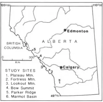
Thus several new studies of localized individual periglacial features have been published since 1978 but the drilling and observation programme started at Plateau Mountain in 1973 remains the only major regional study of the distribution of alpine perma- frost in the region. It is the purpose of this present paper to update the results of this programme to March 198 1. S T U D Y S I T E S 1. Plateau Mtn. 2. Fortress Mtn. 3. Lookout Mtn. 4. Bow Summ~t 5 . Parker Ridge 6. Marmot Basin
FIGURE 1. Locations of the six main study sites in the Rocky Mountains of south-western Alberta.
Method used
The work was based on six locations chosen for their position approximating a line along the length of the mountains in south-western and west-central Alberta (Figure 1).
Boreholes 15 to 30 m deep were drilled at selected locations at each site during the period between 1974 and 1980. A hole 150 m deep was drilled at Plateau Mountain to attempt to determine the minimum thickness of the zone of continuous permafrost beneath the centre of the mountain. At first the holes were instrumented with thermocouple strings, but thermistors were used after 1976. The thermocouples give results accurate to about
+
0.2"C while thermis- tors give results reproducible to f O.Ol°C. Although not all the thermistors proved to be calibrated to this degree of accuracy, the comparative results from one moment of time to another for a given thermistor are reliable.Continuous air temperature data as well as meas- urements of snow depth were collected once a month at the key sites so as to obtain base data for inter- preting the possible climatic causes of the permafrost zones. Measurements of ground temperature have been made at all sites at approximately four-week intervals since the ground temperature cables were placed in position. Notes were also kept of the envi- ronmental conditions at each borehole location.
Results General Permafrost Zonation
The present evidence suggests three zones,
viz.
con-tinuous permafrost, discontinuous permafrost, and sporadic permafrost (Harris 1979). The difference be- tween the last two types is based on an estimate of the abundance of permafrost.
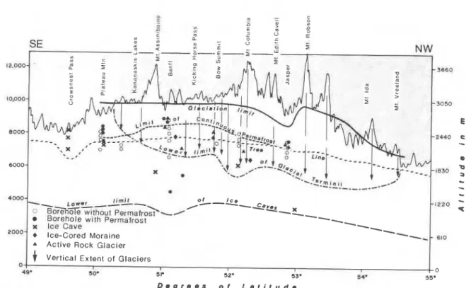
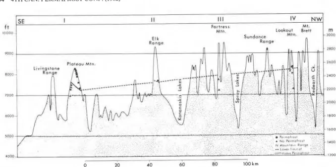
Figure 2 shows the general distribution of perma- frost along the mountains and its relationship to the glaciers, to the glaciation limit, and to the tree-line. The lower boundary of continuous permafrost lies between 2180 and 2575 m above mean sea level, but it does not form a simple north-south gradient. Instead it slopes upward from east to west, while a dome appears to be centred on Bow Summit. Except for Plateau Mountain relict permafrost has not been identified, although it may also occur at the crest of Lookout Mountain.
Discontinuous permafrost forms a narrow zone up to 100 m in vertical extent, unless environmental fac- tors intervene. Within this zone, permafrost occurs at the most suitable sites, while it is absent under less favourable micro-environments, e.g. snow banks.
1
1
A Active Rock GlacierI
1
+
vertical Extent of GlaciersI I 0
48.
1
50. s r 52- 53. 54. 55-1
I D e g r e e s o f L a t i t u d e
FIGURE 2. General distribution of permafrost in a north-west-south-east direction along the mountains and its relationship to the gla- ciers, glaciation limit, and tree-line.
ice bodies at shallow depths beneath peat, and also by ice caves. It occurs through a zone up to 1500 m in vertical extent. Somewhere between Jasper and the extreme north of Alberta, the zone of sporadic permafrost shrinks and discontinuous permafrost becomes widespread.
Specifc Study Sites
The six study sites (see Figure 1) are dealt with in order from south to north.
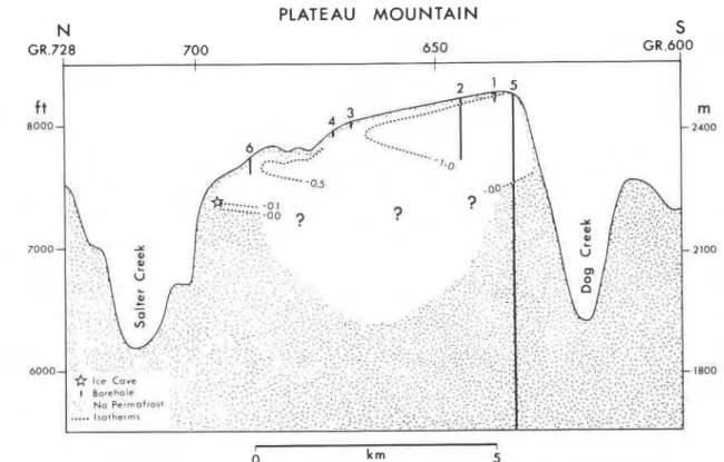
Plateau Mountain: The most southerly site, Plateau Mountain, is situated in the outer mountain range. This was described in detail in Harris and Brown (1978), and there is now enough data to draw a north-south cross section through the mountain (Fig- ure 3). At the south end, the gas-well log (5) indicated 213 m of permafrost, while the borehole drilled in 1978 (2) indicates that the ground temperature is colder than
-
1 "C at a depth of 150 m at the base of the borehole. The base of the zone of continuous permafrost within the mountain appears to be convex downwards.The mountain is unique amongst the study sites in
that it shows no evidence of being overridden by
Pleistocene glaciers and it also shows relict perma- frost. Evidence for this is that the ground ternpera- tures in the top 30 rn invariably get colder with depth
(see Harris and Brown 1978). In the deep borehole, the zone from 60 to 90 m is slightly warmer (O.lS°C) than the zones above and below, and the tempera- tures are only just starting to rise again at the base of the hole.
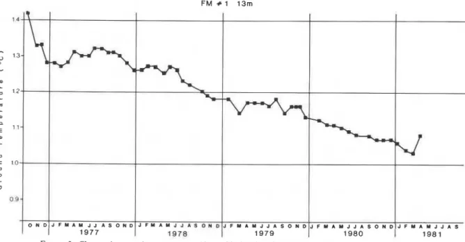
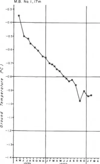
The thermistors and thermocouples show that the measured temperatures are continually adjusting to the climatic variations of the seasons (Figure 4). It takes a year for a heating or cooling wave to penetrate 23 m downwards through the felsenmeer and rock. The surprise is that at the depth normally regarded as "zero amplitude" by previous workers, small sea- sonal fluctuations can be detected, given enough accurate measurements. Thus the level of "zero amplitude" should perhaps be renamed the "depth of minimal amplitude", and defined as being where the ground temperature remains within a range of 0.20°C for a period of more than two years. Using thermo- couple data, this would appear to be a level of zero amplitude. Similar minor fluctuations can be detected in the ice caves and in the deepest boreholes, suggest- ing a minor but continuous variation of the tempera- tures in response to the varying magnitudes of the heat inputs from the ground surface. This makes interpretation of details of the past climates from the ground temperature data extremely difficult, other than for the gross generalization of identifying the presence of relict permafrost.
62 4TH CAN. PERMAFROST CONF. (1982) PLATEAU M O U N T A I N N S GR.728 700 650 GR.600 I I I I I 1 0 k rn 5
FIGURE 3. North-south section showing the proven distribution of permafrost in Plateau Mountain.
FIGURE 4. Ground-temperature data for two thermistors in drill holes at 2286 m on Plateau Mountain. The ground surface is about 30 to 50 m above the limit of near-surface present-day permafrost. Note: the fluctuations in temperature with season. It takes approximately one year for a heating or cooling front to reach 23 m below the surface, but the seasonal fronts can be detected below 30 m, even though it is in the "zone of zero amplitude".
Fortress Mountain: Situated on the third range into
the mountains, three boreholes were drilled here in
1976 below the tree-line, two at 2316 m and one at
2210 m elevation. Unfortunately there is no ready year-round access to suitable locations above tree- line. No site shows permafrost, although the upper site, with an average of 48 cm of mean winter snow, has a mean temperature of about 1 "C at 15 m, even though the temperature data suggest that the ground is still cooling after the disturbance during drilling (Figure 5).
Lookout Mountain (Sunshine Ski Area): Five ther-
mistor strings have been placed in an altitudinal sequence from 1676 to 2712 m at the top of Lookout Mountain. Three of these were located above the tree- line in an attempt to determine the position of the lower limit of continuous permafrost. This appears to lie about 250 m above the tree-line in contrast to being at the tree-line at Plateau Mountain (Figure 6). This upward shift north-westwards disagrees with the basic assumption of Brown (1 967) that the base of the zone of continuous permafrost would rise in altitude consistently towards the equator. The evidence ob- tained in the present study is confirmed and aug- mented by the presence of permafrost at an elevation above 2316 m in the Highwood Pass area, east of Kananaskis (J. Gardner 1977, pers. comrnun.).
Continuous permafrost was encountered at only the highest site, and appears to extend about 150 m down the mountain. However, the ground tempera-
ture at a depth of 30 m on the windswept mountain
crest is lower than - 2.57"C., although the exact tem-
perature is not known since the thermistors are still cooling and recovering from the drilling operation (Figure 7). The base of the narrow zone pf discon- tinuous permafrost occurs at 2570 m on the south- west facing slope of Lookout Mountain at the second borehole.
Bow Summit: This site was investigated before the
dome-shape of the base of the continuous permafrost zone was discovered. It turned out to be the centre of the dome, and the ground temperatures are warmer than at any other site at equivalent elevation (1.85" at 2088 m), even though the air temperatures are un- usually cold. The thermistors at this site are still cool- ing. No permafrost was encountered at the accessible sites.
Parker Ridge, Sunwapta Pass: Here the air tempera-
tures are a little warmer than at Bow Summit and there is a wide range of accessible elevations spanning the tree-line and the alpine zone. Three strings of thermistors indicate permafrost at an elevation of 2276 m with no permafrost below 2250 m except on windswept ridges. Ground temperatures are still adjusting to either a small climatic change or else the warming effect of drilling (Figure 8).
Marmot Basin, Jasper: In March 1979 and 1980, four
strings of thermistors were placed on north and south-facing slopes traversing the tree-line. Although
64 4TH CAN. PERMAFROST CONF. (1982)
0 20 40 60 80 100 k m
FIGURE 6. Inclination of the lower limit of permafrost between Plateau Mountain and Lookout Mountain in south-western Alberta.
the boreholes have yet to complete their cooling from the effects of drilling (Figure 9), it is clear that the base of the zone of continuous permafrost lies at or just below the tree-line on south-facing slopes at 2180 m, and at least 30 m lower on the north-facing slopes. Thus, this site is transitional to the situation in northern Canada where the boundary of the con-
tinuous permafrost zone lies well within the boreal 0 6 - forest.
0 I -,
Relationship to Micro-environment
The most striking feature of the study is the varia-
tion of the elevation of the lower boundary of the
;
;
PR +3 12rn2
; 0 3 a 0 2 u 0 1 - C 0 3;
:
0 0 -\-
\-f\
-0 - 0 1 - 3 1979'7
- , , , , , , , , , , , , , , , , , ,1
. J A S O N O J F M A M J J A S O N D J F M h M l J A S O N 1 D - I I-
7 1 - U-
: 2 2 . III:
z-- 0 1979 1980 1981 1980 1981FIGURE 7. Changes in ground temperature at 30 m depth at 27 12 m FIGURE 8. Changes in ground temperature at 12 m depth at at the top of Lookout Mountain. 2270 m on top of Parker Ridge.
Loakoul Mounram V & \ T -I . H -I * J # . I D * D I r . A C I I ~ I O " P
b5
lt~-\l
,
-'-\ J I M A M > l b > - * D 1.- I 1 m , r- J'? 24m . , , , O M D \,-,-, zone of the continuous permafrost (see Figure 2). It
)
varies independently of the tree-line, with the twoboundaries being approximately coincident at Pla- teau Mountain and on south-facing slopes at Jasper, but the tree-line lies well below the domed lower limit for permafrost in between.
The results of the associated climatic observations
r
during 1980 are listed for each study site (Table 1) andsnow depth appears to be critical (see also Harris and Brown 1978). Where mean winter snow cover greatly exceeds 50 cm, even mean annual air temperatures
(MAAT) of - 6OC (2354" days freezing index versus
150" days thawing index) as at Bow Summit, result in no permafrost being present. The high precipitation of the Bow Summit-Columbia Icefields area appears to insulate the ground and causes the anomalously high level of the lower limit for permafrost, even though the presence of glaciers also causes lower
I
M.B. No. 1 , 17mFIGURE 9. Changes in ground temperature at 17 m depth at 2286 m at Marmot Basin, Jasper.
values of MAAT. Unfortunately the stations were not chosen to determine the exact effects of varying mean winter snow depth and temperatures (or freez- ing and thawing indices). However, a reasonable working hypothesis is that regions with appreciable areas of ice-fields may indicate unusually high alti- tudes for the lower limit of continuous permafrost. Conversely, areas of low winter precipitation may be expected to have continuous permafrost at consid- erably lower altitudes for a given latitude. Thus the elevation of the glaciation limit varies inversely with the height of the lower limit of continuous permafrost at a given elevation.
The effect of aspect is currently being tested at Jas- per, although the present network there is too incom- plete to accurately determine its influence. The cur- rently available data from there and from Plateau Mountain, however, suggest that there is a difference of more than 30 m in the elevation of the zone of con- tinuous permafrost between north- and south-facing slopes. The zone of discontinuous permafrost should be expected to become wider in cold alpine areas with high snowfall, with permafrost occurring where wind blows patches free of snow. Elsewhere, it is limited to a zone of about 25 m in altitude.
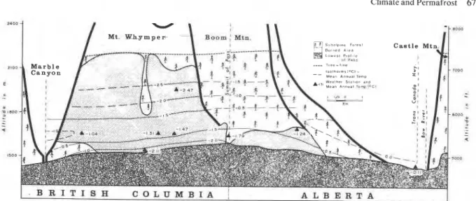
Marked complications in lapse rate occur in passes (Figures 10 and 11) due to the presence of a tempera- ture inversion, usually with its maximum 100 m above the floor of the pass (Harris 1976). This appears to occur regardless of other environmental factors (Figure 12). This is a particular problem in mapping regional permafrost patterns because passes represent the most readily accessible portions of the mountains. This is why multiple boreholes had to be used at each study site, together with measurements of both snowfall and air temperature.
Summary
Since 1973, twenty-eight drill holes ranging from 15
to 150
m
in depth have been instrumented with stringsof thermistors and thermocuples at six study sites be- tween Plateau Mountain and Jasper. The sites are checked at four-week intervals. They have permitted the determination of the general elevation of the lower limit of continuous permafrost through some three degrees of latitude.
The boundary lies between 2180 and 2575 m above mean sea level, but it does not form a simple gradient to the north. Instead, it slopes upward from east to west, while a dome appears to be centred on Bow Summit. This appears to be due to increased snowfall around the ice caps and glaciers, and there may be an inverse relationship between the elevation of the gla- ciation limit and that of the lower limit of continuous
1
B R I T I S H C O L U M B I A , A L B E R T AFIGURE 12. Mean air temperatures in the Vermilion Pass, Banff National Park (after Harris, 1976). Note the marked inversion centred about 100 m above the level of the pass.
Acknowledgements
The authors are indebted to the Division of Build- ing Research, National Research Council, for its con- sistent support. Husky Oil staff have helped with access and safety at Plateau Mountain in winter. The management of the Ski Resorts at Fortress Mountain, Sunshine, and Marmot Basin kindly helped to install the necessary instrumentation in their areas and have helped logistically. Finally, thanks are due to various officials of Parks Canada, who gave permission to carry out the research in the Banff and Jasper Na- tional Parks, and who helped in many little ways in the field. Some of the field work and development work was carried out using funds from NSERC Grant No. A7843.
References
BROWN, R.J.E. 1967. Permafrost Map of Canada. Natl. Res. Counc., Div. Build. Res., NRC 9767, and Geol. Surv. Can. Map 1246A.
CRAMPTON, C.B. 1977. Changes in permafrost distribution in Northeastern British Columbia. Arctic, vol. 30, pp. 61-62.
.
1978. The distribution and thickness of icy permafrost in northeastern British Columbia. Can. J. Earth Sci., vol. 15, pp. 655-659.HARRIS, S.A. 1976. The Vermilion Pass Fire Study: The first seven years. Report for the Parks Branch, Department of Indian Affairs and Northern Development, 176 p.
.
1979. Ice Caves and permafrost zones in southwest Alberta. Erdkd., Band 33, pp. 61-70..
1981. Climatic relationships of permafrost zones in areas of low winter snow-cover. Arctic, vol. 34, pp. 64-70. HARRIS, S.A. AND BROWN, R.J.E. 1978. Plateau Mountain: Acasestudy of alpine permafrost in the Canadian Rocky Mountains. In: Proc. 3rd Int. Conf. Permafrost, Edmonton, Alberta, vol. 1, pp. 385-391.
JACKSON, L.E. AND MACDONALD, G.M. 1980. Movement of an ice- cored rock glacier, Tungsten, N.W.T., Canada, 1963-1980. Arc- tic, vol. 33, pp. 842-847.
KERSHAW, G.P. AND GILL, D. 1979. Growth and decay of palsas and peat plateaus in the Macmillan Pass
-
Trichu River area, Northwest Territories, Canada. Can. J. Earth Sci., vol. 16, pp. 1362-1374.PORSILD, A.E. 1945. The Alpine Flora of the East Slope of Mac- Kenzie Mountains, Northwest Territories. Natl. Mus. Can., Bull. 101 (Biological Series No. 30), Edmond Cloutier, Printer, Ottawa, Ontario, 35 p.
. 1951. Botany of southeastern Yukon adjacent to the Canol Road. Natl. Mus. Can. Bull. No. 121 (Biological Series No. 41), Queen's Printer, Ottawa, Ontario, 400 p.
REVEL, R.D. 1980. Periglacial features from Morfee Mountain, North-Central British Columbia. Arctic, vol. 33, pp. 349-356. SEPPALA, M. 1980. Stratigraphy of a silt-cored palsa, Atlin region,