A DEVELOPMENT STRATEGY AND FEASIBILITY ANALYSIS by Don Klabin Bachelor of Arts Brandeis University, 1969 Master of Architecture Harvard University, 1973 and
David Scott Ross
Bachelor of Environmental Design in Architecture North Carolina State University, 1976
Master of Regional Planning
University of North Carolina at Chapel Hill, 1979
SUBMITTED TO THE DEPARTMENT OF URBAN STUDIES AND PLANNING IN PARTIAL FULFILLMENT OF THE REQUIREMENTS OF THE DEGREE
MASTER OF SCIENCE IN REAL ESTATE DEVELOPMENT AT THE MASSACHUSETTS INSTITUTE OF TECHNOLOGY
AUGUST 1985
@Don Klabin, David Scott Ross 1985 The Authors hereby grant to M.I.T.
permission to reproduce and to distribute publicly copies of this thesis document in whole or in part.
Signature of the authors
Don Klabin Department of Urban Studies and Planning
D. Scott Ross
Department of Urban Studies and Panning
Certified by
Lawrence S. Bacow Associate Professor of Law and Environmental Policy Thesis Supervisor
Accepted by
Lawrence S. Bacow Chairman Interdepartmental Degree Program in Real Estate Development
MASSACHUSETTS iNSTIrUTE OF TECHNOLOGY
A DEVELOPMENT STRATEGY AND FEASIBILITY ANALYSIS
by
Don Klabin and
D. Scott Ross
Submitted to the Department of Urban Studies and Planning in partial fulfillment of the requirements of the degree
Master of Science in Real Estate Development at the Massachusetts Institute of Technology
ABSTRACT
This thesis contains a conceptual plan, feasibility analysis
and development strategy for Allston Landing. The site of
approximately 40 acres at the Allston-Brighton exit to the
Massachusetts Turnpike is owned by the Massachusetts Turnpike
Authority (MTA). The MTA is expected to issue an RFP for
development proposals for the site during the coming year.
The thesis contains an analysis of conditions which will
affect the site's development potential and discusses in
detail the critical issues which must be resolved for
development to proceed. A preliminary market analysis
pro-vides insights into market opportunities and current economic
pro forma assumptions. The information contained in the
analysis was obtained from interviews with community leaders,
city and state officials, private consultants, adjacent
landowners and personal research. This analysis creates the
basis for the proposed development program and plan for the
site. An economic analysis is conducted to demonstrate the
program's feasibility and sensitivity to critical pro forma assumptions, such as land cost and market rent. The thesis
concludes with a development strategy to implement the
proposed plan.
Lawrence S. Bacow
Associate Professor of Law and Environmental Policy Thesis Advisor
A DEVELOPMENT STRATEGY AND FEASIBILITY ANALYSIS
INTRODUCTION . . . . . . . . . . . . . . . . . . . . . . . . 1
CHAPTER ONE : DEVELOPMENT FRAMEWORK. . . . . . . . . . . . . .
Property Characteristics 7
Development Context 18
The MTA - Development Powers and Procedures 25
Development As-of-Right 32
Development Schedule 34
Summary 35
CHAPTER TWO : DEVELOPMENT ISSUES . . . . . . . . .... . ..
Traffic 36
Community Interests 39
Site Control 47
CHAPTER THREE : PLANNING/MARKET OPPORTUNITIES. . . . . . . . .
Planning Opportunities 53
Market Analysis 56
Market Opportunities 62
CHAPTER FOUR : DEVELOPMENT PLAN. . . . . . . . . . . . . . . .
Options 68
Preferred Program 70
Conceptual Plan 73
Phase I 77
Economic Feasibility Model Results
Summary
CHAPTER SIX : DEVELOPMENT STRATEGY . . . . . . . . . . . .
Introduction Site Preparation Structure of RFP Recommended Actions Management Options APPENDICES A. B. Contacts/Directory... Permitted Zoning Uses...
EXHIBITS I. II.
III
IV.
V.
Location Map...
Existing Conditions... Conceptual Plan... Feasibility Model... Sensitivity Graph... TABLES I. II.III.
IV.
V.
Allowable Density via Existing Zoning...
Comparable Market Data...
Allston Landing Development Program...
Sensitivity
-
2 Dependent Variables...
Sensitivity
-
1 Dependent Variable ...
81 82 88 90 93 95 98 99 103 106 2 8 74 85 87 34 59 71 86 86 .. a . . . .
INTRODUCTION
In 1962 the Massachusetts Turnpike Authority (MTA) assembled
the right-of-way for the Boston Extension of the Massachusetts
Turnpike. A particular parcel was taken via the Authority's
power of eminent domain in the vicinity of a proposed toll
plaza and the Allston-Brighton exit. In excess of 40 acres of
land (referred to as Allston Landing) was acquired from
private landowners in the northwest quadrant of the Cambridge Street and Storrow Drive intersection, to accommodate three
essential transportation related functions: 1) the access and
egress ramps at the Allston-Brighton exit, 2) the partial
relocation of the Penn Central Railroad's (ConRail) freight
warehousing operation from the site of the Prudential Center
and 3) the trailer transfer function required by the trucking
companies traveling the turnpike.
Since the construction of the turnpike, ConRail and the MTA have continued to maintain 20 years of active use of the site
as a service hub for freight transport in the Boston
Metropolitan area. The most significant changes to the site
during the interim have not been modifications on site, but
rather exogenous shifts in the locational attributes and real
estate value of the property. Formerly considered to be a
remote location ideally situated for such a transport service function, the site is now considered by many to be one of the most desirable and under-utilized sites in or around Boston.
The site has several distinguishing characteristics which
support this claim. The same transportation network that
provides an efficient support for freight transport is now
perceived by many as an asset which deserves far greater
recognition through more intense development. Most other
sites with comparable accessibility have long since been
developed. Traffic congestion and scarcity of available
parking at downtown locations have placed increasingly higher
economic premiums on properties which can mitigate these
issues and still maintain an identity with the
Boston-Cambridge marketplace. The property's proximity to the
Charles River, its adjacency to the Harvard Business School
and the mere size of 40 plus acres further contribute to the
property's unique development opportunities and enhance its
value.
The MTA is fully aware that the property has enormous
development potential and has expressed interest in pursuing
development options. The Real Estate Division of the MTA is
in the initial stages of conducting its own assessment of
development potential, formulating a credible developer
designation and review process, and structuring an RFP. These
tasks must resolve several major issues in the process. The
first hurdle is a determination by the MTA Board, and
agreement by the MTA's chief engineer, that this property is no longer needed and serves no useful purpose in connection
with the maintenance and operation of the Boston Extension of the turnpike.
The schedule for the issuance of the RFP has not yet been
determined and will depend largely upon the MTA's ability to orchestrate input and establish a review process acceptable to all concerned parties. Any development solution for the site, either through a land lease or sale by the MTA, promises to become both highly competitive and controversial within the
development and political communities, respectively.
Based upon the analysis and understanding of the property,
development issues, and planning and market opportunities,
this thesis attempts to formulate a conceptual development
plan, evaluate its economic feasibility and recommend a
development strategy for Allston Landing.
Chapter One provides an analytic overview of the site,
development context and the development rights under existing
zoning. The legislation which governs the MTA's development
authority is also summarized. Chapter Two out-lines the
essential issues that must be resolved in order to proceed
with development of Allston Landing and presents a range of options and strategies to address each issue. Chapter Three identifies planning and market opportunities for the site.
leaders, city planning officials and state agencies, and a preliminary market analysis.
Chapter Four outlines options for development of Allston
Landing. A preferred development program is presented as a
response to the issues and opportunities discussed in prior
chapters. Chapter Four further describes a conceptual
development plan which attempts to address the main planning issues and organize the program on site. The Phase I program
is used in the feasibility analysis in Chapter Five which
evaluates a base case and the sensitivity of key variables,
including land cost, to a developer's return on equity. Chapter Six concludes with a summary of recommended components
in a development strategy for Allston Landing.
The reader must recognize that this effort attempts to define a preferred development program, conceptual plan and strategy
which is several years in advance of any on-site activity.
The political and economic climates may change dramatically in the next few years and the development issues will become more clearly defined. The major decisions made during the course of this effort are based upon the current understanding of issues and opportunities and, in some instances, reflect the authors' rational expectations about future conditions.
Much of the information contained in the analysis section was
community leaders, public officials, tenants and professional
consultants. Approximately 60 such interviews were conducted
during the preparation of this paper, and every attempt was
made to contact the key players. A complete listing of
persons contacted, along with their relative affiliation is
contained in Appendix A. Given the practical limits of time
and availability, it was necessary in certain cases to seek
representative views from selected persons. For this reason,
the authors do not contend the analysis to be exhaustive.
We wish to extend our most sincere gratitude to all those who gave of their time and energy in assisting in this effort.
CHAPTER ONE
DEVELOPMENT FRAMEWORK
This chapter is intended to provide an analytic overview of
existing development parameters for Allston Landing. Physical property characteristics which may influence the site's
devel-opment potential are summarized. The site's context is
de-scribed by recent activity in the area and an overview of
concerns and interests of the abutters. The development
authority and legislative procedures of the MTA with respect
to development of surplus property and air rights is
dis-cussed. This chapter concludes by summarizing the
as-of-right development potential under existing zoning.
Property Characteristics
Site Definition:
Allston Landing is an approximate 40 acre parcel that has been
owned by the Massachusetts Turnpike Authority since 1962
(refer to exhibit II). The Allston Landing assemblage
includ-ed over 20 separate parcels via the eminent domain powers of
the MTA and represents only a fragment of the total land
assembled to accommodate the relocation of Penn Central
(ConRail) rail yards from the site of the Prudential Center.
The site is located within the city limits of Boston in the
This paper will refer to three separate areas relative to planning for the MTA property which are outlined in exhibit II and defined as follows:
Planning District: This includes approximately 49 acres
of land inclusive of the MTA and Sears parcels. The
district is defined by public rights of way and a
distinct neighborhood boundary.
Allston Landing: This is the entire land area owned by
the MTA on the northwest corner of the Cambridge
Street/Soldier's Field Road intersection. The property
measures approximately 39 acres and includes
approx-imately 5 acres of ramp right of way and 19 acres of
ConRail permanent easement.
Phase I: The Phase I parcel is defined as the land area
owned by the MTA which is presently unencumbered by
outside property interests which would prohibit immediate
-development. This constitutes the Soldier's Field Road
frontage and turnpike ramp right of way totaling
approximately 14 acres.
Boundaries:
The edges to the property are clearly defined on three sides
cre-ated by Western Avenue, directly across from the Harvard
Business School. Fronting uses include a surface parking lot
and 5 level parking garage which services Soldiers Field Park,
a 475 unit, market rate, married student housing project for
Harvard University.
Soldiers Field Road, a four-lane limited access thoroughfare
owned and maintained by the Metropolitan District Commission
(MDC), establishes the eastern boundary.
Two at-grade
ser-vice lanes on either side of the through lanes combine to
create a formidable pedestrian barrier of
8 traffic lanes
within a 150 foot right of way between Allston Landing and the
Charles River. The MDC owns an approximate 0.5 acre parcel at
the Western Avenue/Soldier's Field Road inter-section.
The southern boundary is defined by Cambridge Street between
Soldiers Field Road and Windom Street.
A major segment of
this section of roadway is
elevated to allow an 18-foot
clearance for the Turnpike ramps and ConRail tracks which are
located within the 40 acre parcel. Neighboring to the south
is the newly constructed 310 room Embassy Suite Hotel by The
Beacon Companies, Houghton Chemical Co. plant and additional
ramps servicing the Turnpike.
The western edge to the property is quite irregular by
comparison, both in terms of its physical boundary and
neighboring uses.
Portions of Allston Landing extend to
Windom Street, a public right of way which generally defines
the eastern limit of a well defined and stable single family
neighborhood in North Allston.
Housing in this neighborhood
is developed at approximately 10 units per acre.
Sears
Roebuck and Company owns and operates a regional warehouse and
repair facility on 10 acres which borders the MTA property on
three sides
and single family residences along Windom Street.
Facilities for radio and television station WGBH are located
along Western Avenue, immediately west of the site.
Access:
Access to the turnpike links the site directly into the major
highway network which services the Boston Metropolitan area.
Depending upon traffic conditions, an approximate ten minute
trip via the Turnpike and 1-93 connects the core of Boston's
Financial District to Allston Landing.
Headed west, it is
only a 10 minute trip to Route 128, 25 minutes to interchange
with 1-495 and approximately 15 minutes to the Framingham and
Natick communities to the west.
Soldiers Field Road and
Storrow Drive provide direct and efficient access to the more
local destinations in Boston, Cambridge and Newton.
These
timely
and
efficient
connections
to
existing
major
residential,
commercial
and
retail
markets
afford
unparalleled
opportunities with other available development
Zoning:
Allston Landing
is currently zoned within two separate
industrial
zoning
classifications;
M-1, Restricted
Manu-facturing at an allowable FAR of 1.0 and 1-2, General
Industrial at an allowable FAR of 2.0. These zoning districts
were in existence when the MTA acquired the property. The
first 300
feet (approximate) of frontage along Soldiers Field
Road is
zoned M-1 with the balance of the property and the
adjoining Sears tract zoned 1-2.
Allowable and conditional
uses as defined by the Boston Zoning Code are listed in
Appendix B.
Existing Uses/Easements:
As mentioned earlier, Allston Landing is presently used by the
MTA and ConRail for the transport and warehousing of freight
by the truck and rail industries. Both operations are vital
to the efficient servicing of the Metropolitan Boston area and
collectively utilize the full extent of their available land
area.
The MTA makes use of the area within the ramps as a break-up
area for tandem trailers using the Allston/Brighton exit of
the turnpike.
The make-up for the cabs and stored trailers
occurs in the paved area which abuts Soldier's Field Road.
The terminal at this location is operated by a tenant at will.
The lease contains a 30-60 day termination grace period and
does not create a problem with reuse of the site. However, prior to any development which may occur in this Phase I area, the MTA must find an alternate site for relocation of this
activity. Relocation costs, over and above land value, are
expected to be minimal. All on site service drives and rights of way are owned by the MTA.
ConRail has a perpetual easement interest in approximately 19
acres of Allston Landing (refer to exhibit II). Referred to
as Allston Yard, this area is used in the transfer and
warehousing of rail freight. Upon abandonment of this use,
the easement is dissolved and the property reverts to the MTA.
A rail line extends beneath the Cambridge Street overpass to connect Allston Yard with the unloading and switching of
trailer vans at Beacon Park. The function of Allston Yard is
critical to rail service in the Boston area and must maintain some proximity and relation to the Beacon Park operations.
Aside from the ConRail easement, there are other public
utility easements which encumber the development of Allston
Landing. The MDC South Charles relief sewer traverses the
western end of the property in a north-south direction at
approximately 15 feet below grade. This can be paved over at
The MDC also holds a 50 foot wide subsurface easement for its
350 foot deep water supply. This traverses the site in a northeasterly direction and does not create any significant
constraint on development. The MDC would be concerned if
there were to be extensive blasting or pile driving in the
immediate vicinity of the easement.
The southeastern corner of the site contains the turnpike
ramps. The inclusion of this area within Phase I permits
either the creative use of air rights above the ramps or their relocation for a more efficient ramping system. The MTA has
indicated an interest in improving this alignment and the
congested traffic conditions at the Cambridge Street/Soldiers Field Road intersection.
Environmental Issues:
Traffic: The immediate roadway system surrounding the site is
presently inadequate to accommodate significant amounts of
additional traffic destined for Allston Landing. Traffic must
funnel through the Cambridge Street/Soldiers Field Road
intersection, weave two lanes to the left within a distance of only 100 feet to make a left hand turn, and proceed to Western
Avenue to enter the site. The congestion at the Cambridge
Street intersection presently measures a Level of Service D.
This access problem, along with the fact that the existing
stations, will require significant alterations to the overall
traffic network. Any significant program proposed for the
site must include improved turnpike ramp access.
A related environmental traffic concern is the amount of truck
traffic which services the MTA, ConRail and Sears operations. Trucks which may service these or other industrial uses in the immediate area must be reconfigured to prohibit routing through neighboring residential streets.
Utilities: Numerous utilities border the site: domestic
water, natural gas, sewer/storm, electrical and telephone
lines. The only utilities crossing the site are a 4" gas line
traveling east-west along the right of way extending from Rotterdam Street and the utility easements mentioned above.
Based upon a brief review of the Embassy Suites Hotel
con-struction documents and the project correspondence with the various utility companies and review authorities, it appears that there are no significant utility constraints on future
development at the Allston Landing site. The only possible
exception is the need for further improvements to the existing combined sewer/storm system in the vicinity of the site and the resolution of an outfall location for the future on-site piping.
Subsurface Conditions: In the fall of 1983 Haley & Aldrich, Inc. (H & A) performed extensive subsurface investigations and
geotechnical studies at the site of the new Embassy Suites
Hotel. The most significant conclusions of these reports
relevant to the Allston Landing site are the following:
(1) Groundwater - Based upon a three month survey of eight observation wells, the stabilized groundwater table
appears to be within the range of Elevation 6.9'-10.9'
BCB, which is from 0.9' below to 4.3' above the
relatively constant level of Charles River at Elevation
7.6' BCB. A maximum groundwater level at Elev. 11.5' was
recommended by H & A for design purposes at the hotel
site. This is approximately six feet below the majority
of existing grades at the Allston Landing site. Thus, dewatering and waterproofing will be required for the structured parking, elevator pits, gas and oil separating
tank and other below-grade construction. This does not
impose a significant cost premium on the project.
(2) Soils and Foundation - A brief review of the MTA
Engineering Department records revealed that no borings have been taken within the boundary of the Allston
Landing site. The H & A reports indicated that existing
miscellaneous fill
and organic deposits in the uppermost
strata are inadequate for the use of shallow footings to
support medium-rise buildings. Piles must be driven
deposits which overlay the bedrock. Temporary surcharging of the existing fill will be necessary.
In conclusion, these findings indicate that the existing
subsurface conditions do not impose any special risks or
excessive construction premiums for new development.
Topographic: There is no topographic relief to the entire
planning district. Based upon the vertical datum of the
Boston City Base, the property averages an elevation of 17
feet.
Views: The views, both to and from Allston Landing, comprise
one of the site's most valuable assets. Development of any
scale will have immediate recognition upon exiting the
turnpike and along the main arterials of Soldiers Field Road
and Memorial Drive. This view presently consists of
ware-houses and parked trailers, yet there is an opportunity for a
strong address and creation of a much needed high quality
development identity for Allston. The views from the site
above the second floor capture vistas of the Charles River,
the Harvard Business School campus and Harvard Square to the
north, and the Back Bay and Boston Skyline to the south. More immediate views of the Charles River, Esplanade and Cambridge lie to the east.
Noise:
The heavy traffic volumes and pace of traffic flow
along Soldiers Field Road create undesirable noise levels
while standing at grade.
Even greater noise levels are
gen-erated by traffic on the turnpike ramps as traffic is
accel-erating on the access ramp.
Development Context
Recent Developments:
The Embassy Suites Hotel, a 310 suite hotel on the southwest
corner of Cambridge Street and Soldiers Field Road, is owned
by The Beacon Companies and is
scheduled to open this fall.
This recent development activity has stirred concern in the
Allston community that development of Allston Landing is
imminent.
The stoutly proportioned building contains 160,000 gross
square feet reaching to a maximum height of
180 feet. The
design and material selection for the hotel has been
contro-versial.
Design criticisms
include the hotel's poor overall
proportions, monotonous facade treatment of bland masonry and
boxy fenestrations, randomly aligned pitched roofs and its
"shoe-horned" site accommodation.
The Allston community appears to be mostly concerned about the
"cold shoulder" that the tower turns toward the community and
the increased traffic congestion. The building attempts to maximize views of the Charles River, Cambridge and downtown
Boston and screen the Houghton Chemical Co., the hotel's
immediate neighbor to the west. As a result, the western
building facade is particularly unattractive and suggests a
disassociation with the Allston community. This controversial
design, has heightened community emotions and sensitivities
toward any new development at Allston Landing.
Although the development of the hotel did not require a
rezoning, several variances were sought by Beacon and granted
by the BRA.
These variances, such as building height and
setbacks, were not major issues of contention in the process.
The focus
of nearly
everyone's attention
was
on the
transportation issue which took in excess of one year to
resolve.
The other major community fear relative to the hotel
devel-opment will not be confirmed until the hotel is in full
operation later this year. The increased traffic volumes
attempting to negotiate the Cambridge Street/Soldiers Field
road intersection may exacerbate the intersection's existing congestion.
In 1984, the MTA and Con Rail carried out a land swap which
amounted to a reconfiguration of the ConRail easement
by the MTA, exchanged approximately three acres of prior
ConRail easement within the current Phase I boundary, with an approximately equivalent land area along Western Avenue. This was instituted to create a contiguous land area of reasonable proportion to accommodate an initial phase of development.
The MTA made public its intention to investigate the potential development of this site and initiated the pre-RFP process in
the fall of 1984. In December of that year, Chairman
Driscoll, at the request of the community, called a meeting to outline the preliminary thoughts of the MTA and dispel rumors
of a "wired" developer designation process. Driscoll assured
the community that there would be extensive community
participation via a task force including community
representatives in both the formulation of an RFP and design
review if it proceeded. No task force has been formed to
date, although Chairman Driscoll has announced that another informational meeting will be held in September.
Abutters:
The following discussion provides a summary of the concerns expressed by the abutters to Allston Landing regarding future development of the site.
Harvard Business School: The Harvard Business School (HBS)
assist in the re-examination and master planning of the Harvard Business School's campus and real estate. The Western Avenue frontage, which is presently used as a surface parking
lot, is considered the most likely area for institutional
expansion. The HBS has considered basically two options
regarding expansion toward Western Avenue: (1) continue to
treat this frontage as a "back door" with parking and service
functions, or (2) organize expansion around a major new
entrance to the HBS campus from Western Avenue. The second
option is preferred by the HBS planners but is highly
contingent upon a major image upgrade of Western Avenue, including generous landscaping and compatible development at
Allston Landing. Western Avenue is regarded as an important
boundary to the HBS campus and there is no desire to expand beyond this edge.
The main concerns of the HBS regarding development at Allston Landing include the following:
1) The Western Avenue image should be visually and
environmentally compatible with the long range HBS plans to possibly create a new heavily landscaped entrance off of Western Avenue.
2) Traffic conditions at the perimeter of the HBS should
not be significantly worsened with new development.
3) The HBS must maintain and preserve the desirable
4) The northern edge of Allston Landing should be complementary in scale and use with the HBS campus.
Harvard Real Estate: The Harvard Real Estate (HRE) is the fee
owner of Soldiers Field Park housing and garage at the corner
of Western Avenue and Soldiers Field Road. HRE has no current
interest in expanding the housing or garage facilities and
shares the concerns of the HBS outlined above.
Metropolitan District Commission (MDC): The MDC owns the land between Allston Landing and the Charles River, including the
approximate 0.5 acre parcel southwest of the Western
Avenue/Soldiers Field Road intersection. The MDC's primary
concerns regarding development of Allston Landing relate to
setbacks and building massing along Soldiers Field Road and
the Charles River. The MDC's planning department has
expressed the need for an improved open space connection
between Cambridge and Western Avenue. This could be
accomplished by a waterside boardwalk or public open space frontage across the Allston Landing site. The MDC would like
to see a 100 foot building setback from Soldiers Field Road
and a building form which steps in height away from the water.
The Beacon Companies: Beacon is the developer and owner of
the Embassy Suites Hotel which is scheduled to open this fall.
Beacon is not only interested in the development of Allston
the role of developer for the site. Any quality development
which is complementary to the hotel would be encouraged as
enhance-ment to the hotel's location.
Beacon's primary concern is traffic engineering and management
of the existing roadway network which services the hotel.
Given the existing traffic congestion which exists at critical
pressure points, Beacon would have difficulty supporting any
development at
Allston Landing
which would generate a
significant level of traffic without a substantial improvement
to the traffic circulation system.
This most likely would
include turnpike ramp relocation and upgrading of the Western
Avenue and Cambridge Street intersections with Soldiers Field
Road.
Beacon is widening a triangular shaped portion of
Cambridge Street between the merging turnpike exit ramps and
Soldiers Field Road. This is to mitigate the current crowding
of three traffic lanes into a two and one-half lane width
roadway.
A secondary interest is improved pedestrian access
to the hotel from Allston Landing and Cambridge.
Houghton Chemical
Corporation (HCC):
The Ho
ughton Chemical
Corp. is
a family-owned
and
managed
-chemical
distribution
business located immediately west of the Embassy Suites Hotel.
No manufacturing occurs on-site since the primary function of
the business
is distribution of organic solvents for the
northeast U.S. markets.
The business has been in operation
since the
early 60's and no relocation is planned or
desirable. Beacon was unsuccessful in negotiating HCC's relocation for additional surface parking for the hotel.
HCC's main off-site concern is traffic related. The existing
traffic congestion complicates access to the site for both
trucks and automobiles. The company participated with Beacon
in the widening of the turnpike off-ramp to improve access to Soldiers Field Road and would likely oppose any development at Allston Landing which did not successfully resolve traffic impacts.
Sears Roebuck and Co.: The Sears warehouse and repair
facility west of Allston Landing pre-dates the construction of the Massachusetts turnpike in Allston. Sited on approximately
10 acres of land, the current facility of 280,000 gsf is not
capable of expansion. With increased volumes and demand for
space, Sears has been forced to rent an additional 80,000 gsf
at a nearby location. This facility is vital to their New
England operations and benefits greatly from its direct access into the interstate highway network.
Sears Roebuck and Company is currently evaluating its national
distribution network. The most efficient system for future
distribution may require numerous strategically placed, high
frequency, mini-warehouses in contrast to the high volume,
large inventory warehouses such as the Allston facility.
warehouse in Allston may become obsolete. At present however, Sears operates the facility at capacity and is unaware of any alternate sites which would be more ideally located for their needs.
Due to the high volumes of trucking activity involved in their operations, Sears' primary concern is maintaining efficient
access to their warehouse. In order to bypass congestion on
the main arteries, some truck traffic is presently enticed to
seek a path of lesser resistance through the adjoining
neighborhood streets.
The Massachusetts Turnpike Authority - Powers & Procedures
In order to fully understand the as-of-right development
potential for Allston Landing, it is necessary to evaluate the development powers and land use control procedures of the MTA. The MTA was created by the Legislature of the Commonwealth of
Massachusetts via Chapter 354 of the Acts of 1952. This
enabling legislation, as amended, along with the 1962
Supplemental Trust Agreement govern the MTA's rights regarding use of the Allston Landing site. Relevant excerpts from these documents are discussed below.
The enabling act created the MTA as an independent "public
instrumentality" and "not subject to the supervision and
regulation of the department of public works or any other
department, commission, board bureau or agency ... ". The
Authority consists of three members appointed by the governor
with advice from and consent of the council. Each member is
appointed for an 8 year term and one is designated Chairman.
Section 5 of the enabling act grants the general powers of the
MTA. It authorizes the MTA "to acquire, hold and dispose of
real and personal property in the exercise of its powers."
The initial requirement in the disposition process is a
determination by a majority vote of the Board that the real
property "is not needed and serves no useful purpose in
connection with the maintenance and operation of the Boston
Extension." The MTA may grant easements or concessions for
the use of surplus land or grant air rights subject to the condition that the lease or grant will not prejudice the efficient operation of the turnpike. The consulting engineers for the MTA, Howard Needles Tammen & Bergendoff, must approve of the determination by the Board prior to formal declaration of surplus.
Once real property is declared surplus, Chapter 81 Appendix,
subsection 1-5 (q) stipulates the procedure for disposition.
If the property is not being sold to the commonwealth, city,
value in excess of $5,000, then a public bid process is
required.
Pursuant to the advertisement procedures outlined
in the act, the award of real property interest is granted to
the "highest
responsible bidder".
In the decision of Village
on the Hill, Inc. v. Massachusetts Turnpike Authority (1964),
the court decided that although the MTA is exempt from local
zoning provisions, this does not exempt a current owner from
local zoning provisions on land once owned by the MTA that was
declared excess and transferred by the MTA.
Section 7
enumerates the "Incidental Powers" of the MTA which
grants that:
"the Authority may sell the buildings or other structure
upon any lands taken by it, or may remove the same, and
shall sell, if a sale is practicable, any lands or rights
or interest in lands on other property taken or purchased
for the purposes of this act, whenever the same shall, in
the opinion of the Authority, cease to be needed for such
purpose."
and,
"contract with any person, partnership, association, or
corporation desiring
the use of any part thereof,
including the right of way adjoining the paved portion,
-for placing thereon telephone, telegraph, electric light
or power lines, gas stations, garages and restaurants, or
for any other purpose, and to fix the terms, conditions,
rents and rates of charges for such use;".
Chapter 81,
Appendix subsection 1-7
clarifies the MTA's
eminent domain powers in any reconstruction or additions to
the turnpike relative to public utilities.
It grants the
power to take via eminent domain
"such land abutting the turnpike as it may deem necessary
or desirable for the purposes of removing or relocating
all or any part of the facilities of any public utility,
including rail lines, and may thereafter lease the same
or convey an easement or any other interest therein to
such utility company upon such terms as it, in its sole
discretion may determine."
This power has particular relevance to the ConRail activity at
Allston Landing.
The MTA has the authority to take via
eminent domain property abutting its right of way for the
relocation of this activity.
It is conceivable that such a
taking may be exercised in any realignment or reconstruction
of the existing ramps at Allston/Brighton.
Chapter 81,
Appendix subsection 1-15A of the MGL governs the
MTA's "Utilization
of Air
Rights."
The MTA is authorized to
make leases not to exceed 99 years for air rights over land
owned or held by the MTA.
There are no restrictions on the
use of such air rights except the conditions that it, in the
opinion of the MTA, "will not impair the construction, full
use, safety, maintenance, repair, operation or revenues of the
Massachusetts Turnpike,"
and that any lease in excess of 40
years is subject to approval by the governor.
This act also confers that air rights leased within the
territorial limits of the City of Boston is subject to the
provisions of the State building code,
"but shall
not be
subject to any building, fire, garage, health or zoning
ordinance, rule or regulation applicable in the city of
Boston." The act further states that the MTA shall not lease
in the city of Boston, unless the MTA, "after consultation
with the mayor", finds that the new development "will preserve
and increase the amenities of the community." Developments
constructed on leased air rights are taxed to the lessee as if the lessee owned the land in fee with no part of the value of the land included in the tax assessment.
Chapter 81, Appendix subsection 1-15B of the MGL governs the
"Utilization of Excess Land." This authorizes the MTA to
grant land leases with similar parameters as outlined for
utilization of air rights. The single major difference is
that under such a land lease, any development shall be subject
to "building, fire, and zoning laws, ordinances or by-laws
applicable in the city or town where such building or other
thing is located." At Allston Landing, via a sale or ground
lease, this would require compliance with the Boston Zoning
Code as administered by the BRA. Developments on land leases
are taxed to the lessee as if the lessee owned the land in
fee, with no part of the value of the land included in the tax assessment.
Trust Agreement:
A Supplemental Trust Agreement was executed in January of 1962 (1962 Agreement) between the MTA and it's Trustee, the First
Extension". This provided for the extension of the turnpike from Route 128 into downtown Boston.
Article 4, Section 404 of the 1962 Trust Agreement identifies
the creation of an "Improvement Account" and payment
procedures for improvements deemed appropriate as necessary by the MTA. The 1962 Agreement further defines "improvements" to
"...embrace and shall be limited to any additional
traffic lanes, truck and bus terminals, gasoline, service
and repair stations, restaurants, parking facilities,
additional interchanges or ramps to facilitate the flow
of traffic and enlargements thereof, including in each
case entrances, exits, acceleration and deceleration
lanes and extensions thereof, and toll collection
facilities."
These improvements can be made by the MTA upon determination of need by the MTA Board. If any modification or expansion of the ramps at Allston/Brighton would facilitate the traffic flow to and from the turnpike, the MTA could undertake this improvement within its legislative powers.
Disposition Terms:
In addition to the legislation, several of the recent
agreements between the MTA and private developers were
reviewed to determine a likely sale or lease structure for Allston Landing. The MTA clearly prefers to execute long term leases on the property. The term of recent comparable leases,
is not variable with the project's cash flow, but is typically generated by the interest on a long-term government security (treasury bond) held in escrow by the MTA escrow agent. This form of payment offers the least risk exposure to the MTA. The developer however is required to purchase a treasury bond at the outset of the project which provides an annual yield equivalent to the market ground rent negotiated with the MTA.
It appears most likely that the MTA will seek to arrange a lease agreement in the form mentioned above. Given the scale of Allston Landing and the potential long term build -out, it also seems reasonable that the MTA would permit the developer
to take down the property on a pre-negotiated schedule,
contingent upon the MTA's ability to deliver the land and the developer's phasing projections.
Summary:
The liberal wording of the enabling act creates no legislative
limit to the eventual use of property owned by the MTA when
contracting with
an outside developer or agency.
The
political limitations of reasonable and practical exercise of
these powers appear to be the primary restraint on the
development powers of the MTA.
The MTA has two paramount objectives when reviewing the reuse
or alteration to any of its holdings. Any improvements or new
developments must: (1) enhance, if possible, but in no measure diminish the safe and efficient operation of the Massachusetts Turnpike and (2) facilitate, and in no measure
jeopardize, the repayment of bonds issued by the MTA to its
shareholders.
Mention should be made of the perception of the MTA as a
landowner of significant proportions in Allston. The
acquisition of the right of way for the Boston Extension in
the early sixties through the Allston community was a bitter
battle waged between local community interests and an all too powerful creature of the Commonwealth. The Turnpike alignment through Allston bisected North Allston from the greater
Allston/Brighton community. This severance by the turnpike
remains in the minds of many long established Allston
residents as an open wound in their neighborhood fabric. The
recognition of this continuing adversative relationship
between the MTA and Allston community is fundamental in
establishing a politically plausible development strategy for Allston Landing.
Development Potential As-of-Right
The as-of-right development for Allston Landing is governed by the MTA's enabling legislation, in the case of improvements by
developed by an outside party, the Boston Zoning Code governs
the development as administered by the BRA.
A literal interpretation of the existing industrial
zoning
classification generates in excess of 4 million gross square
feet for the Allston Landing planning district. This equates
to an overall 1.9 FAR.
The breakdown of maximum allowable
density by area within the planning district is
defined in
Table I below.
Permitted uses with the respective zoning
classifications are identified in Appendix B.
The maximum
allowable "as-of-right"
figures in
Table I
are
theoretical
computations based upon zoning allowance and do not reflect
potential density restraints resulting from traffic
con-ditions, open space and parking requirements.
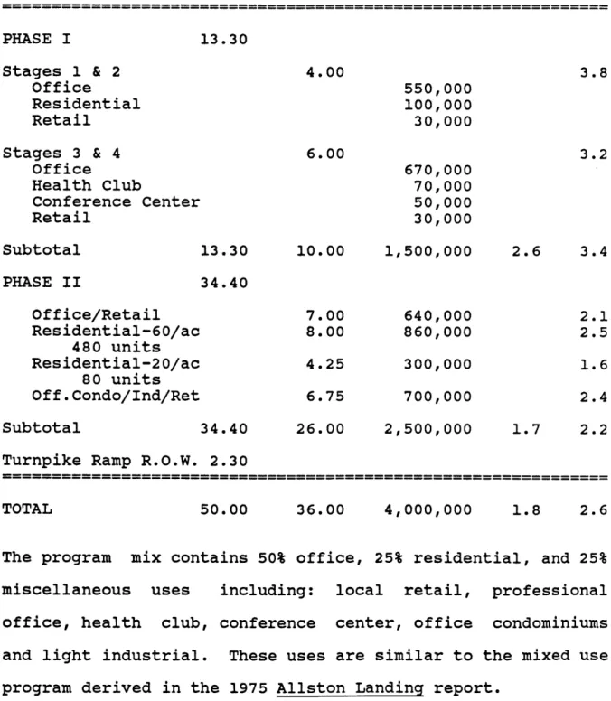
TABLE I
Allowable Density via Existing Zoning
Land Area Zoning FAR
(acres) Allowable Sq. Feet MTA -ConRail Phase I
Other
Subtotal
Sears
Residential
Total
FAR
19.26 I 2 1,678,000 6.75 I 2 588,000 7.20 M 1 313,600 5.64 I 2 491,400 38.85 3,071,000 9.75 I 2 849,500 1.40 I 2 122,000 50.00 4,042,500 1.86Owner
The development of close to 4 million gross square feet within the planning district could obviously not be supported by the
existing roadway system. Congestion would increase
signif-icantly if some of the existing industrial and warehouse uses
are replaced by office use, which has close to three times the number of employees per square foot of space.
Development Schedule
There is no proposed schedule for development of Allston
Landing by the MTA. The following list of events and approx-imate time frames attempts to forecast an approxapprox-imate date for occupancy of the first building.
Prepare RFP with community and state input: Proposal preparation by developers:
Proposal review and developer designation: Public approvals and permits:
Financing commitments:
Phase I construction documents:
Site preparation (off site improvements): Construction Total:
Time (yrs.)
1.0-1.5 0.5 0.5-1.0 1.0-2.0+ 0.5+ 1.0 0.0-1.0 1.5-2.0 6.0-9.5 yrs. 1. 2. 3. 4. 5. 6. 7. 8.Adjusting for the fact that some of the events can occur
simultaneously, it appears that the most optimistic scenario
would project occupancy for phase I to occur in 5 years, or the year 1990.
Summary
The physical characteristics of the Allston Landing site
create no significant constraints on its future development
potential. The primary constraints on development are related
to three basic issues.
1). The roadway network and traffic conditions must be
significantly improved to provide safe and efficient access to Allston Landing, the turnpike, and surrounding community.
2). Any new development at Allston Landing must carefully
address the physical and functional relationship to the
Allston community. The development must respond to the urban
design objectives and desired mix of uses in order to obtain political acceptance and approvals.
3). Site control of the Sears and ConRail parcels is critical
for Allston Landing to achieve its highest development
CHAPTER TWO
DEVELOPMENT ISSUES
Chapter Two discusses the three critical development issues as determined by the analysis in Chapter One. General recommen-dations are presented to resolve the traffic and community
relations issues. Site control of the Sears and ConRail
parcels is discussed along with available options and
strategies.
Traffic
Allston Landing is effectively an island surrounded by heavily
used traffic routes which operate at full capacity for both
regional and local travel of trucks and autos. There is no immediate access to the site from the turnpike. In addition, the Cambridge Street/Soldiers Field Road intersection bears
the dubious distinction of ranking among the top 10 worst
intersections in the state, making it a priority for
correc-tive action by the state administration. Any development
proposal for the site must recognize and remedy these
conditions.
Vanasse/Hangen Associates, traffic engineering consultants to The Beacon Companies for the Embassy Suites Hotel, recently prepared a memorandum on traffic conditions at the turnpike
off ramp. It cited the morning peak period as being so
difficult that MDC police are required for manual control
since it "...equates to a Level of Service C/D while the
evening operates near Level of Service D." This ranks
signif-icantly below the original design level and is regarded as substandard.
The memorandum describes the most critical daily period after completion of the Embassy Suites Hotel to be the morning peak
hour when a projected 94 additional right turns can be
expected to occur from Cambridge Street onto Soldiers Field
Road. When added to existing right turn movements, this would create a Level of Service D.
The evening peak hour is projected as an "almost
inconsequential change" over existing conditions approaching
Level of Service D. Proposed improvements to the existing
network related to the hotel development consists of widening
of the exit ramp area by approximately ten feet at the
westerly property limit. This improvement should relieve some existing congestion and provide improved access to the site.
There will be access only via Soldiers Field Road and exit
only onto Cambridge Street in order to avoid increased
congestion.
The extensive perimeter of the site and the magnitude of its future development creates an opportunity to reconstruct the
roadway network, to improve existing traffic conditions and
support the incremental traffic generated by the new
development. This will depend in part upon the availability
of highway/ infrastructure funding.
Options:
The following alternative strategies could be employed in
dealing with the existing traffic:
1) Leave all ramps and intersections as is and
'downzone' the site accordingly;
2) Provide minor improvements to the stressed network
(e.g. additional turning lanes, modify signalization,
etc.) in an effort to mitigate incremental increases in
traffic; or
3) Provide major changes to the network which include
relocated ramps, widened roadways and improved
inter-sections on both sides of the river.
The existing network is already over capacity during peak
periods which would constrain new development. Incremental
improvements have been constructed over time to increase the
capacity of the streets. These improvements serve as band
problem. Option 3 appears to be the only alternative which
can assure the highest and best use of the Allston Landing
site and protect the long-term interests of the community.
The costs associated with option 3 would be extensive. In
order to protect the developer's economic feasibility of the
project, a cost sharing formula between the developer, City,
State and MTA should be considered. It is important to note
that the MTA has not participated in cost sharing for
infra-structure improvements in any of its recent dispositions of
ground or air rights (Copley Place, Wang Labs, Westfield
Office Park). However, given the regional importance and
severity of this situation, it may be possible to have the MTA
participate in cost sharing with subsequent compensation by
the developer through a supplement to the ground lease.
Community Interests
As stated by various residents, neighborhood leaders and community development staff during recent community meetings,
it is imperative that community participation be a vital,
ongoing component of the development process for the Allston Landing site. The wound created by the schism of the Allston-Brighton neighborhood by the land taking for the Boston Extension of the turnpike has not been forgotten over the past
23 years. This imminent site development process offers the challenging potential of rallying and re-unifying many of the
various splinter groups behind a well thought out program of community amenities to be included in the new development.
Interests:
In 1975 the debate over the location of Kennedy Library in the vicinity of Harvard Square stirred sufficient interest among the North Allston community and Harvard University to jointly
undertake a land use planning process for Allston Landing.
The purpose of the process was to identify future development
prospects for the site which were consistent with both market
opportunities and abutters' concerns. The product from this
effort was published by the North Allston/Harvard Land Use Task Force in a report entitled Allston Landing.
Although the report is somewhat dated now and the
represen-tatives on the Task Force may not be of identical persuasion as the current community leaders, the community goals and preferred program alternatives provide a useful insight into
the probable interests and positions that will surface as
development of this site becomes more imminent. Six community
goals for future development were enumerated in the report
which can be summarized as follows:
1) New development should complement the existing
neighbors and enhance the character of the existing neighborhood;
2) New development should alleviate truck traffic from neighborhood streets and access directly from the turn-pike if possible;
3) A complete mix of housing types should be provided
within economic constraints (the Allston Civic
Asso-ciation desired elderly housing);
5) Public open space should take advantage of river
frontage and provide recreational areas for new and old
communities;
6) Any plan must be capable of implementation
predominantly by the private sector.
The report further identified market opportunities for office,
residential and retail sectors through market research
provided by Gladstone Associates. Given that the market today
is dramatically different from its condition in 1975 and
forecasts and projections were extended only to 1985, the
market data is no longer appropriate. What is still of
valuable insight, however, is the preferred program of uses by the Allston Civic Association (ACA) and Harvard University.
The Task Force rejected both a regional shopping center and
industrial expansion on the basis of adverse traffic impacts
and undesirable perpetuation of incompatible uses,
respec-tively. Acceptable uses included a mix of residential units
ranging from elderly and low-moderate income apartments to
office space, a small local shopping center and both recrea-tional and riverfront open space.
The North Allston/Harvard Task Force advanced these
development goals and acceptable market opportunities into a
preferred program and conceptual land use plan for Allston
Landing. The Sears facility was not considered as integral to any new development, and the ConRail easement and operation was not recognized as a development constraint. The
concept-ual plan contains significant strategic omissions by not
addressing the phasing or integration of these existing uses and, from our viewpoint is neither practical nor viable.
The attempt in 1975 to translate prescribed goals and program
into a conceptual plan gave birth to some general planning and design criteria which illustrated an acceptable development solution to the Task Force. These criteria included:
1) Reducing truck traffic through community and
arresting the sprawl of light industry;
2) Establishing a new residential image for the area;
3) Transforming Western Avenue from its currently
industrial image into a community street with housing,
shops and offices on the south side complementing
academic development on the north side;
4) Providing a range of housing opportunities;
5) Connecting the existing Allston community to the
6) Creating a riverfront park along Soldiers Field Road
7) Maintaining a low-medium building scale along the
river, representative of the Soldiers Field Park housing complex;
8) Positioning taller structures at appropriate setbacks
from the river.
Although the Allston Landing report was prepared ten years ago
within a fundamentally different set of political, economic
and market conditions, it remains the most comprehensive
articulation of community interests to date, and the goals, market preferences and criteria summarized above must be
factored into any development proposal.
Community Participation:
In the last fifteen years community participation in Boston has undergone a dramatic shift from a confrontational,
anti-development stance, to a more cooperative, product oriented
one. This did not occur by chance or without difficulty.
From the resistance to the Park Plaza proposal of 1971, which
resulted in 100% successful obstruction, to the successful
product oriented Citizens Review Committee (CRC) providing
written development guidelines to the Copley Place project
during 1977-80, to the recent BRA sponsored Citizens Advisory
Committees, there has been a healthy transition from a win-lose style of negotiation to a win-win style.
Some of the same major public sector players who were active
in the Copley Place project are still influential today:
John
Driscoll, the MTA chairman;
Governor Dukakis;
Frank Keefe,
Office of
State Planning;
Fred Salvucci, Secretary of
Transportation.
The new Mayor and BRA Director create a
favorable climate today for real estate development in the
city, especially for larger scale projects which inherently
can compensate for those things which Proposition 2 1/2
inhibits the city budget from providing.
Within Allston there is currently no apparent umbrella
organ-ization or elected representative which has taken a leadership
role with respect to Allston Landing. There is an ill-defined
organizational structure to the many civic organizations and
associations (Community Development Corporation
-
CDC, Allston
Civic Association
-
ACA, South Allston Neighborhood
Associa-tion
-
SANA, etc.).
The Allston-Brighton CDC has provided
professional planning skills to assist in the implementation
of community objectives, such as commercial revitalization and
community housing, but it is not a strong political force.
The ACA
has historically
been
effective
in
leading
major
issues but has yet to put Allston Landing at the top of their
agenda.
In addition, the mayor, BRA director, and city
councillors representing Allston have refrained from taking a
position towards the development of this site. This
leader-ship vacuum will be filled by the group or representative who manages to most forcefully express the major issues.
Presently there is no firm consensus to what the critical
issues should be at Allston Landing. Aside from the
discus-sion in the Allston Landing report, four generic issues have
emerged from recent community discussions. These include;
traffic (local and highway), public open space, density (bulk,
and height), mixed use and housing. The mission of the
community participation process will be to expand and articu-late the issues to the lead agency.
Interest in the future of Allston Landing has been stimulated
by the recent actions of the MTA. The local cable television station conducted a panel discussion on the subject in June
which was attended by several community leaders and
representatives. The CDC recently hired Stockard & Engler
Inc., community planners, to assist in some preliminary
planning strategies for the community. A meeting set for
Sep-tember by the MTA Chairman is likely to intensify community
interest.
The Copley Place model is an appropriate paradigm because of
its modus operandi. It began with a totally open invitation
to all concerned parties, whether designated leaders or
concerned individuals. It proceeded to concentrate the parti-cipants' attention on the definition of issues, not approval/