University of Neuchâtel Faculty of Sciences
Centre for Hydrogeology and Geothermics
MULTIDISCIPLINARY APPROACH TO UNDERSTAND THE
LOCALIZATION OF GEOTHERMAL ANOMALIES IN THE UPPER RHINE
GRABEN FROM REGIONAL TO LOCAL SCALE
Thesis presented at the Faculty of Sciences of the University of Neuchâtel to satisfy the requirements of the degree of Doctor of Philosophy in Science
by
Paul Baillieux
Thesis defense date: December 18th, 2012
PhD thesis evaluation committee:
Prof. Eva Schill University of Neuchâtel (CH) Thesis director
Dr. Chrystel Dezayes BRGM Orléans (FR) Jury member
Dr. Albert Genter GEIE EMC Soultz (FR) Jury member
•
U11
1e
UNIVERSITé CE NEUCHÂTEL
Faculté des sciences · Secrétariat-décanat de Faculté ·
Rue Emlle·Argand 11
2000 Neuchâtel • Suisse
Tél:+ 41 (0)32 718 2100 E-mail: [email protected]
IMPRIMATUR POUR THESE DE DOCTORAT
La Faculté des sciences de l'Université de Neuchâtel
. .autorise l'impression de la présente thèse soutenue par
Monsieur Paul BAILLIEUX
Titre: Multidisciplinary approach to understand the localization of
geothermal anomalies in the Upper Rhine Graben from regional to
local scale
sur le rapport des membres du jury:
• · Prof. Eva Schill,_ Université de Neuchâtel, directrice de thèse • Prof. Philippe Renard, Université de Neuchâtel
• Dr Albert Genter, GElE Soultz, Kutzenhausen, France
• Dr Chrystel Dezayes, · BRGM, Orléans, France
Neuchâtel, le 26 février 2013 · · Le Doyen, Prof. P. Kropf
General abstract
This thesis is devoted to understanding the localization of geothermal anomalies in extensional tectonic settings away from active volcanic areas. In this context, the European Cenozoic Rift System (ECRIS) hosts some of the major geothermal anomalies in Europe. Its central segment, the Upper Rhine Graben (URG), stretching over 300km between Basel (Switzerland) and Frankfurt (Germany), reveals several surface heat flow anomalies in the order of up to > 150 mW m-2 (compared to an average of 60 mW m-2 in Europe) and temperatures up to 120°C at 1km depth, when usually a mean temperature gradient of 30°C km-1 is observed.
In the Upper Rhine Graben, geothermal activity has mainly been attributed to free hydrothermal convection at graben scale, as well as free convection along the major faults in the area of Landau and at the European Enhanced Geothermal System (EGS) test-site Soultz.
These local phenomena emphasize that temperature is not homogeneously distributed in the URG and neither are geothermal anomalies. Different geological facts were solicited to explain the localization of geothermal anomalies in the URG. The geothermal anomaly at Soultz has been on the one hand attributed to recent compressive shear strain occurring parallel to the central segment of the graben, allowing hydrothermal circulation to occur along favorably oriented fracture zones in the basement and in the high porosity sandstone aquifer above it. On the other hand it has been correlated to the lithological nature of the basement and its inherited orientations.
In this thesis, 3D geological modeling, boreholes temperatures distribution, gravity, magnetics, slip and dilation tendencies analysis, neotectonic activity and geodynamic modeling have been used to investigate geological patterns associated with the localization of geothermal anomalies at graben-wide scale (the URG) and pluri-kilometric scale (in the area of the EGS Soultz).
The comparison of geophysical data with the temperature distribution at graben scale has shown that zones of temperature highs can be related to the occurrence of low density basement that can be attributed to crystalline ridges offering an optimal radiogenic heat production and heat conductivity but also to porosity changes associated with faulting and hydrothermal circulation. In particular, zones of magnetic highs and gravity lows are related to additional temperatures in the order 10-20°C at 2000m true-vertical depth (TVD) at a graben wide scale (temperature 100-110 °C compared to a mean 90°C with minimum value of 75°C).
Additionally, the occurrence of compression shear and uplift regime, with low Quaternary sedimentation, in the central segment of the URG appears to be linked to the major geothermal anomalies (120 to > 140 °C at 2000 m TVD) in the area of Soultz, Landau and Speyer. This may be explained by a change in tectonic regime from the Early Miocene to up to Present, and is in favor of the interpretation of the central segment of the URG being a restraining band separating two-pull apart basin in a sinistral strike-slip regime. Surprisingly, a relative low seismicity is observed in this area, which to an uncertain extent, maybe linked to the occurrence of naturally circulating fluids. More locally in Soultz area, a new 3D geological model has been elaborated on the basis of a high density set of 2D seismic profiles and deep boreholes to understand the links between structural and v
lithological patterns and the temperature distribution. A mean temperature anomaly of 40 °C at top basement has been linked to a light and magnetic granodioritic pluton offering a rather high radiogenic heat production. Moreover, hydrothermal circulation has been found to occur along N-S directed major faults with a West dipping signature in the western side of horst structures, and is held responsible for temperature anomalies above 60 °C, and this correlates with magnetotelluric observations and fracture orientations in Soultz boreholes. The majority of faults are favorably oriented in the current stress field to be reactivated and undergo dilation at depth and thus allow hydrothermal convection, but no clear relationship between these phenomena has been observed in the slip and dilation tendency analyses, and this can possibly be explained by asymmetric deformation patterns in the area, or by the sealing of the other faults due to intense mineralization. Another possible explanation is the fluid circulation characterized by an upward flow of hot water with a meteoric signature as a result of fluid inclusions analyses, and this deep circulation is interpreted to be coming from the Vosges mountain basement to the West, and this correlates with gravity residuals analyses.
Finally, the geodynamic modeling of the graben opening showed that simple models can explain the patterns of deformation observed along the deep seismic profiles perpendicular to the graben. In particular, the observed graben asymmetric geometry is reproduced and asymmetric localized faulting is observed on the side opposite to the master fault accommodating the majority of vertical deformation.
Keywords
Upper Rhine Graben; Geothermics; Geothermal Energy; Enhanced Geothermal Systems; EGS; Hydraulic Permeability; Hydraulic Conductivity; Geophysics; Gravity; Gravimetry; Magnetics; Geodynamics; Seismicity; Tectonic Processes; Temperature; Neotectonic Activity; Radiogenic Heat Production; Hydrothermal Circulation; Fault; Stress; Strain; Crustal Extension; Extensional Tectonics; Soultz; Magnetotellurics; Porosity; Slip and Dilation Tendency Analysis; Uplift; Compression; Extension; Subsidence; Basement Rocks; Granite; 3D Geological Modeling; Geology; Hydrogeology; Thermal Anomalies; Crystalline Basement; Graben System; Magnetism; Neotectonics
Organisation of this thesis
The present thesis is organized as a succession of 5 chapters, three of which were prepared for submission to scientific journals. The topics of the individual chapters and the contributions of the various authors are outlined below.
Chapter 1: Introduction
This chapter presents the foundations studies and main objectives of the present thesis, the geological framework and methodology thereby applied.
Chapter 2: Localization of temperature anomalies in the Upper Rhine
Graben: insights from geophysics and neotectonic activity
By
Paul Baillieux, Eva Schill, Jean-Bernard Edel and Guillaume Mauri
This chapter proposes to compare the observed temperature distribution at depth in the Upper Rhine Graben with the different map associated to explanations for its localization. It illustrates how geophysical data and neotectonic patterns can be linked to the temperature distribution. The contribution of these different sources is qualified semi-quantitatively.
The first author looked through the literature to find the solicited explanation for the localization of the temperature anomalies and drew the different maps, and eventually wrote a first draft of the paper. The second author offered scientific questions and suggestions and helped shaping ideas and text. The third author contributed in the paper by sharing the geophysical database and its geophysical and geological experience on the studied area. The fourth author helped in reviewing the manuscript.
Chapter 3: Insights on the localization of temperature anomalies in
Soultz area from gravity, magnetics and slip and dilation tendency
analysis
By
Paul Baillieux, Eva Schill, Yassine Abdelfettah and Chrystel Dezayes
This chapter proposes a higher resolution and more local approach to link the temperature distribution with observed structural patterns, with the surface geophysical data around the area, and the observed local stress patterns, around the area of the European EGS test-site Soultz, in the recently developed 3D geological model (Appendix A and B). The contribution of these different sources is qualified semi-quantitatively.
Firstly, the first author constructed the 3D geological model with the help of all other authors (Appendix A). Secondly, the first author used this 3D geological model as a basis for studying the temperature distribution and constructed the different maps to quantify the contribution of the different possible sources to explain the distribution of temperature, and eventually wrote a first draft of the manuscript. The second author offered scientific questions and suggestions and helped shaping ideas and text. The third author was involved in the different steps of the geophysical processing. The fourth author helped in reviewing the manuscript with its long experience in the field.
Chapter 4: Investigation of natural permeability in extensional
tectonic settings: insights from a 2D geodynamic modeling of the
Upper Rhine Graben opening
By
Paul Baillieux, Eva Schill and Louis Moresi
This chapter offers a new approach to understand the creation and development of natural faulting and hydraulic conductivities in a graben system through geological time using geodynamics modeling, with emphasis on geothermal application. A recently developed geodynamics code which allows the modeling of complex long-term geological processes and enables the user to visualize the geological creation of complex geometries such as brittle faulting, mantle upwelling in continental extension for example, has been used. For benchmarking these models, seismic sections through the Upper Rhine valley were selected.
The first author carried out analyses to set up geodynamic models in order to approach reasonable scientific and practical questions raised by the topic. He wrote a first draft of the manuscript, which was improved by the second author. The third author, as a specialist in geodynamic modeling, helped both in creating the geodynamic model and reviewing the manuscript.
Chapter 5: Summary, discussion and conclusions
This chapter summarizes the results described in previous chapter, and discusses the impact of the different chapters to the understanding of the localization of geothermal anomalies in the Upper Rhine Graben.
Appendix A: 3D structural regional model of the EGS Soultz site
(northern Upper Rhine Graben, France): Insights and perspectives
ByPaul Baillieux, Eva Schill and Chrystel Dezayes
Presented in: Thirty-Sixth Workshop on Geothermal Reservoir Engineering at Stanford University, 2011
This conference paper presents the insights and perspectives from the new 3D geological model of the EGS Soultz area, with emphasis on geophysical and structural patterns such as the orientations and density of regional faults and their link to reservoir fractures, as well as a first interpretation of the temperature distribution at depth.
Appendix B: 3-D visualization of a fractured geothermal field: The
example of the EGS Soultz site (northern Upper Rhine Graben,
France)
By
Chrystel Dezayes, Laurent Beccaletto, Gwennole Oliviero, Paul Baillieux, Laure Capar and Eva Schill Presented in: Thirty-Sixth Workshop on Geothermal Reservoir Engineering at Stanford University, 2011
This conference paper presents the geological data and procedure used to build the new 3D geological model including the fault network of the EGS Soultz area.
Table of Content
General abstract ... v
Organisation this thesis ... vii
Chapter I: Introduction ... 21
1.1 Main objectives of the PhD thesis ... 21
1.2 Geological framework ... 26
1.3 Methodology ... 29
1.4 References ... 30
Chapter II: Localization of temperature anomalies in the Upper Rhine Graben: insights from geophysics and neotectonic activity ... 33
Abstract ... 33
2.1 Introduction ... 33
2.2 Geological settings ... 35
2.2.1 Pre-Permian Basement in the URG ... 35
2.2.2 Structural development of the Upper Rhine Graben ... 37
2.2.3 Recent stress and strain distribution ... 38
2.3 Data processing ... 40
2.3.1 Temperature interpolation ... 40
2.3.2 Compilation of geophysical data ... 42
2.4 Results and discussion ... 43
2.4.1 Temperature distribution in the URG ... 43
2.4.2 Links between geophysical grids and temperature... 46
2.4.3 Links between recent stress and strain rate-hydrothermal convection ... 50
2.5 Conclusions ... 51
2.6 Acknowledgements ... 52
2.7 References ... 52
Chapter III: Insights on the localization of temperature anomalies in Soultz area from gravity,
magnetics and slip and dilation tendency analysis ... 57
Abstract ... 57
3.1 Introduction ... 57
3.2 Geological settings ... 59
3.2.1 Pre-Permian Basement inferred from Geophysics ... 59
3.2.2 Structural development of the Upper Rhine Graben ... 60
3.2.3 3D structural model of the Soultz area ... 61
3.3 Data processing ... 63
3.3.1 Temperature data... 63
3.3.2 Geophysical data ... 64
3.3.3 Slip and dilation tendencies analysis ... 65
3.4 Results and Discussion ... 67
3.4.1 Temperature distribution at top basement ... 67
3.4.2 Geophysics ... 70
3.4.3 Slip and dilation tendencies analyses ... 76
3.5 Conclusions ... 79
3.6 Acknowledgements ... 80
3.7 References ... 80
Chapter IV - Investigation of natural permeability in extensional tectonic settings: insights from a 2D geodynamic modeling of the Upper Rhine Graben opening ... 85
Abstract ... 85
4.1 Introduction ... 85
4.1.1 Review of geodynamic modeling of continental extension ... 87
4.2 2D crustal extension of the Upper Rhine Graben ... 88
4.2.1 Methods ... 88
4.2.2 Sensivity study ... 89
4.2.3 Variation in viscosity ... 89
4.2.4 Comparison with independent geophysical data ... 94
4.3 Discussion and implication for geothermal exploration ... 95
4.4 Conclusions ... 95
4.5 Acknowledgements ... 95
4.6 References ... 95
Chapter V: Discussion and conclusions ... 99
Outlook ... 102
References ... 102
All references ... 105
Acknowledgements ... 113
Appendix A: 3D structural regional model of the EGS Soultz site (northern Upper Rhine Graben, France): Insights and perspectives ... 115
Appendix B: 3-D visualization of a fractured geothermal field: The example of the EGS Soultz site (northern Upper Rhine Graben, France) ... 124
Curriculum Vitae of Paul BAILLIEUX ... 131
Table of figures
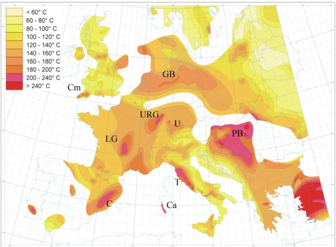
Figure 1-1 : Map of temperature in Europe extrapolated to 5km depth - modified after Genter (2004) and Hurtig et al. (1992). URG: Upper Rhine Graben; U: Urach - molasse basin area; LG: Limagne graben-French Massif Central; C: Catalonia; Ca: Campidano graben; Cm: Camborne granite; GB: German basin; T: Tuscany; PB: Pannonian Basin. ... 22
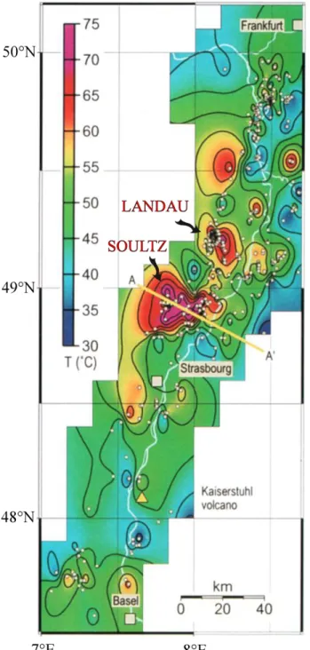
Figure 1-2 : Temperature contour map of the Rhine Graben at a depth of 800 m modified after Pribnow and Schellschmidt (2000). Profile AA’ approximately corresponds to cross-sections in Figure 1-4 and Figure 1-5. ... 23
Figure 1-3 : top) Outline of a typical Enhanced geothermal system (EGS) for heat and electricity production in a fractured crystalline rock (after CREGE, 2010, Neuchâtel, Switzerland, www.crege.ch) bottom) Photograph of the surface EGS power plant of Soultz (Soultz GEIE EMC, France, www. http://www.geothermie-soultz.fr). ... 24
Figure 1-4 : Generalized cross-section through the Rhinegraben South of Karlsruhe showing hydrothermal convection in shear controlled fissures of the basement, but heat conduction in the sedimentary fill (Illies et al., 1981). ... 25
Figure 1-5 : 2D computed temperature field across Soultz and Baden-Baden geothermal areas, modified after Sausse (1998) and Le Carlier de Veslud et al. (1994). Interpretation of fluid flow field (blue arrows) after Pribnow and Schellschmidt (2000)... 25
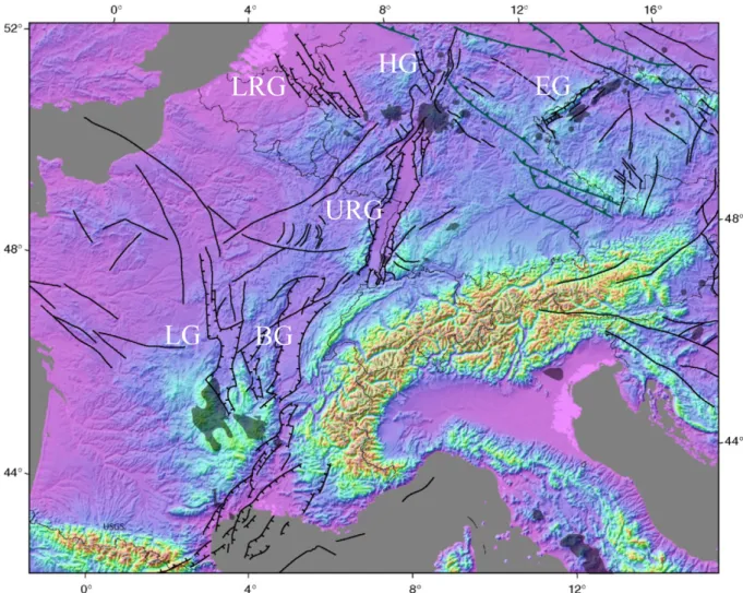
Figure 1-6 : Emplacement of Graben Systems on the Digital Elevation Model of the European Cenozoic Rift System (ECRIS) area with superimposed ECRIS fault systems (thin lines), based on GTOPO30 with horizontal grid spacing of 30 arc sec, USGS, modified after Ziegler and Dèzes (2007). LRG: Lower Rhine Graben; HG: Hessian Graben; EG: Eger Graben; URG: Upper Rhine Graben; LG: Limagne Graben; BG: Bresse Graben. ... 26
Figure 1-7 : Geological overview map of the Upper Rhine Graben area, modified after Lahner and Wellmer (2004) and Christian Röhr, 2006 (http://www.oberrheingraben.de) . OMh: Odenwald Mountains high; PWh: Pfälzerwald high; KGd: Kreichgau depression; PBd: Pflazburger depression; VMh: Vosges Mountains high; BFMh: Black Forest Mountains high. Location of the geothermal anomalies of the European EGS test-site Soultz, Landau and Speyer (red stars). Dashed blue lines approximately indicate location of traces of the cross-sections of Figure 1-8. ... 27
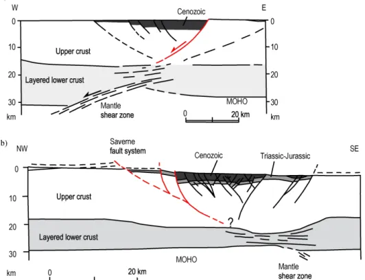
Figure 1-8 : Interpreted cross-sections of the Rhine Graben from the ECORS-DEKORP seismic investigation of the crustal structure of the Upper Rhine Graben. a) northern profile. b) southern profile. Red lines denote the interpreted master fault accommodating the maximum offset. Modified after Brun et al. (1992) and Valley (2007). Locations of cross-sections on Figure 3. ... 28
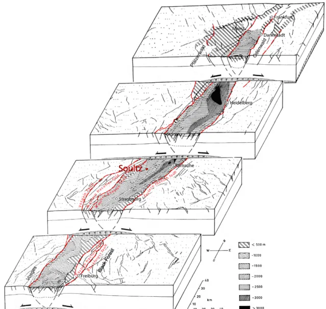
Figure 1-9: Block diagrams of the general Rhine Graben structure. Various hatching corresponds to the thickness of the Cenozoic sedimentary fill. Modified after Illies (1972) and Valley (2007). Location of the European EGS test-site Soultz (red point). ... 29
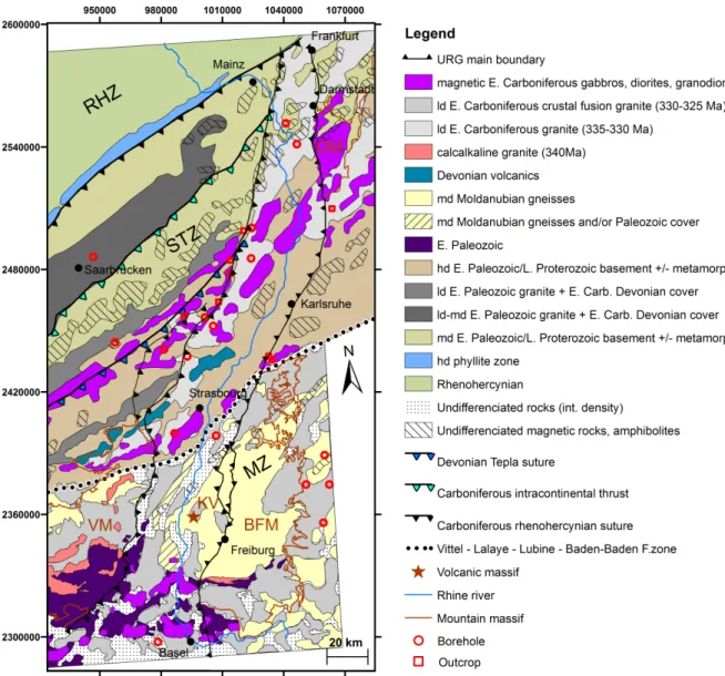
Figure 2-1 : Compilation of Edel (2004) and Edel and Schulmann (2009) interpretative maps showing the major units and tectonic features beneath the pre-Late Carboniferous - Permian basin. ld :low density; md: medium density; hd: high density; RHZ:Rhenohercynian Zone; STZ: Saxo-Thuringian Zone; MZ: Moldanubian Zone; VM: Vosges mountains; BFM: Blackforest mountains; OM: Odenwald mountains; KV: Kaiserstuhl Volcanic massif. Lambert II coordinates. ... 36
Figure 2-2 : Map showing the interpretation of neotectonic activity of the Upper Rhine Graben including the main direction of stress, adapted from Illies & Greiner (1979), the thickness of
quaternary sediments, after Schumacher (2002), and the present day seismic activity, after Ahorner (1975; Schumacher, 2002), Bonjer (1997), Plenefisch & Bonjer (1997), Edel et al. (2006). VM: Vosges mountains; BFM: Blackforest mountains; OM: Odenwald mountains; KV: Kaiserstuhl Volcanic massif. Lambert II coordinates. ... 39
Figure 2-3 : Distribution and quality of borehole temperature measurements in the URG area.
Categories of quality among the measurements come from the study by Agemar et al. (2012). ... 41
Figure 2-4 : Temperature distribution at 2000 m TVD in the Upper Rhine Graben (URG) derived from a 3D interpolation of 6531 temperature data from 1600 boreholes from the URG and adjacent areas using the dataset of Pribnow & Schellschmidt (2000) and Agemar et al. (2012). The location of the two main petroleum and geothermal areas at Pechelbronn/Soultz-sous-Forêts and Landau are indicated. The boreholes with a depth > 2000 m TVD are indicated by triangles. VM: Vosges
mountains; BFM: Black Forest mountains; OM: Odenwald mountains; KV: Kaiserstuhl Volcanic massif. Lambert II coordinates. ... 44
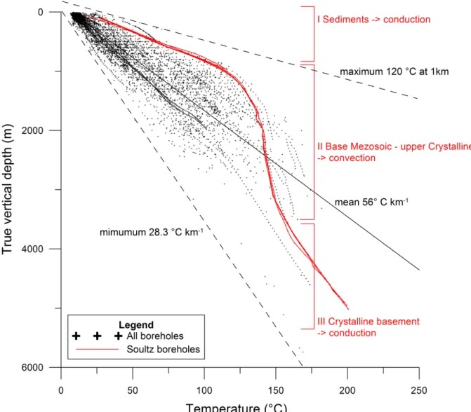
Figure 2-5 : Temperature distribution with depth in the boreholes of the URG and surroundings (after Pribnow & Schellschmidt (2000) and Agemar et al. (2012), with emphasis on the Soultz boreholes (red) and expected temperature regime in Soultz area (e.g. Kohl et al., 2000). ... 45
Figure 2-6 : (left) Superposition isolines of temperature at 2000 m TVD after Pribnow and
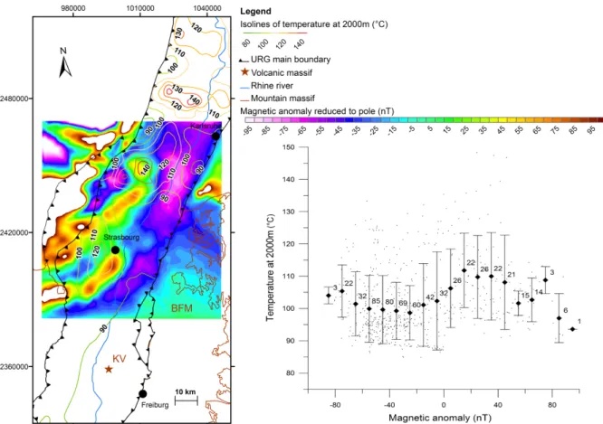
Schellschmidt (2000) and Agemar et al. (2012), and magnetic anomaly reduced to pole map after Edel et al. (1982) and Papillon (1995); VM: Vosges mountains; BFM: Black Forest mountains; OM: Odenwald mountains; KV: Kaiserstuhl Volcanic massif. Lambert II coordinates. (right) Graph representing the mean value and standard deviation of temperature values at 2000 m TVD corresponding to the magnetic anomaly (10 nT interval). Label number indicates the number of information that has been used to calculate the mean value and standard deviation. ... 47
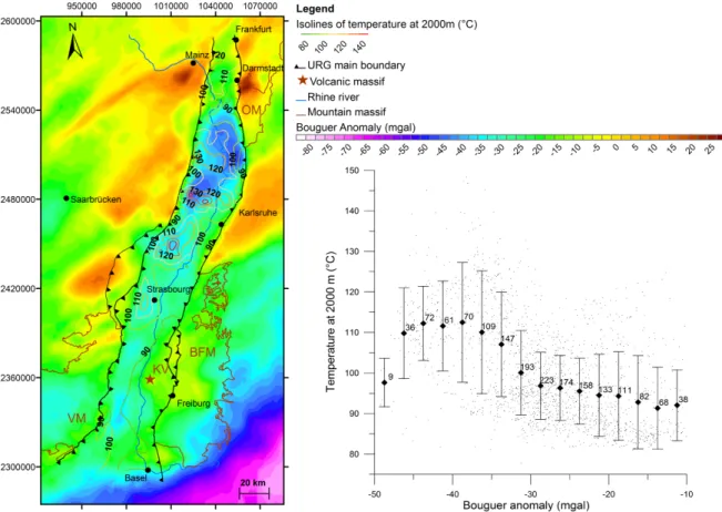
Figure 2-7 : (left) Superposition isolines of temperature at 2000 m TVD after Pribnow and Schellschmidt (2000) and Agemar et al. (2012), and Bouguer Anomaly map after Rotstein et al. (2006); VM: Vosges mountains; BFM: Black Forest mountains; OM: Odenwald mountains; KV: Kaiserstuhl Volcanic massif. Lambert II coordinates. (right) Graph representing the average and standard deviation of temperature values at 2000 m TVD corresponding to the Bouguer Anomaly (2.5 mgals interval). Label number indicates the number of information that has been used to calculate the mean value and standard deviation. ... 48
Figure 2-8 : (left) Superposition isolines of temperature at 2000 m TVD after Pribnow and
Schellschmidt (2000) and Agemar et al. (2012), and Gravity vertical gradient map after Edel et al. (2007); VM: Vosges mountains; BFM: Black Forest mountains; OM: Odenwald mountains; KV: Kaiserstuhl Volcanic massif. Lambert II coordinates. (right) Graph representing the average and standard deviation of temperature values at 2000 m TVD corresponding to the Gravity vertical gradient (0.5 mgal/km interval). Label number indicates the number of information that has been used to calculate the mean value and standard deviation. ... 49
Figure 2-9 : Map representing the superposition temperature at 2000 m TVD after Pribnow and Schellschmidt (2000) and Agemar et al. (2012), and interpretation of neotectonic activity of the Upper Rhine Graben adapted from Illies & Greiner (1979), and the present day seismic activity, after Ahorner (1975), Bonjer (1997), Plenefisch & Bonjer (1997), Edel et al. (2006). VM: Vosges mountains; BFM: Blackforest mountains; OM: Odenwald mountains; KV: Kaiserstuhl Volcanic massif. Lambert II coordinates. ... 50
Figure 3-1 : Compilation of Edel (2004) and Edel and Schulmann (2009) interpretative maps showing the major units and tectonic features beneath the pre-Late Carboniferous - Permian basin. ld :low density; md: medium density; hd: high density; mag: high magnetic susceptibility;
RHZ:Rhenohercynian Zone; STZ: Saxo-Thuringian Zone; MZ: Moldanubian Zone; VM: Vosges
mountains; BFM: Blackforest mountains; OM: Odenwald mountains; KV: Kaiserstuhl Volcanic massif. Lambert II coordinates. ... 60
Figure 3-2 : Interpretation of neotectonic activity in the upper Rhine Graben after Illies and Greiner (1979). Superposition of fault traces (Illies and Greiner, 1979), thickness of Quaternary sediments -after Bartz (1974) and Schumacher (2002). The mean direction of stress is adapted from Illies and Greiner (1979; 2002). VM: Vosges mountains; BFM: Blackforest mountains; OM: Odenwald
mountains; KV: Kaiserstuhl Volcanic massif. Lambert II coordinates. ... 62
Figure 3-3 : visualization of the geological model of the Soultz area (31x18.5x6 km). The upper tertiary sedimentary filling was intentionally left transparent for best visualization. Location of the model area on Figure 3-1 and Figure 3-2. ... 63
Figure 3-4 : Top basement elevation, fault traces and dip directions (black lines) at top basement in the area of the 3D geological model. Red star indicates the location of the European EGS test-site Soultz. ... 64
Figure 3-5 : Temperature distribution in the 112 boreholes of Soultz area. Database from Pribnow and Schellschmidt (2000) and Agemar et al. (2012). ... 68
Figure 3-6 : Visualization of the temperature distribution at -1000, -2000 and -3000 m above sea-level, temperature measurements distribution along boreholes (red crosses) and 3D basement elevation (grey) within the limited area of the 3D geological model. Temperature database from Pribnow and Schellschmidt (2000) and Agemar et al. (2012). ... 68
Figure 3-7 : Temperature anomaly at top basement, distribution of temperature measurements and their distance to top basement, and fault traces and dip directions (black lines) at top basement in the area of the 3D geological model. A temperature gradient of 39.2°C per km, corresponding to the lowest observed temperature gradient in the area, is subtracted from the temperature field at top basement to obtain this temperature anomaly map at top basement. Temperature database from Pribnow and Schellschmidt (2000) and Agemar et al. (2012). ... 69
Figure 3-8 : Distribution and quality of borehole temperature measurements in the area of the 3D geological model. Categories of quality among the measurements come from the study by Agemar et al. (2012). ... 69 Figure 3-9 : (top) Magnetic anomaly reduced to pole, surface features from the 3D model (fault system, horizons) (bottom) Magnetic anomaly reduced to pole, surface features from the 3D model (fault system, horizons) and contours of temperature anomaly at top basement ... 72
Figure 3-10 : (top) Bouguer anomaly with reference density 2670 kg m-3, surface features from the 3D model (fault system, horizons). (bottom) Gravity forward response of the model with reference density 2670 kg m-3, and surface features from the 3D model (fault system, horizons). ... 73 xviii
Figure 3-11 : (top) Gravity residuals after 20 km Butterworth filter, and surface features from the 3D model (fault system, horizons). Red circles refer to zones of low gravity residuals described in the text. (bottom) Gravity residuals after 80 km Butterworth filter, and surface features from the 3D model (fault system, horizons). Red circles refer to zones of low gravity residuals described in the text. ... 74
Figure 3-12 : (top) Gravity residuals after 20 km Butterworth filter, surface features from the 3D model (fault system, horizons) and contours of temperature anomaly at top basement. (bottom) Gravity residuals after 80 km Butterworth filter, surface features from the 3D model (fault system, horizons) and contours of temperature anomaly at top basement. ... 75
Figure 3-13 : Bouguer anomaly with reference density 2670 kg m-3, surface features from the 3D model (fault system, horizons) and contours of temperature anomaly at top basement ... 76
Figure 3-14 : Slip tendency on the fault system of the 3D geological model. ... 77
Figure 3-15 : (top) Slip tendency on the fault system at top basement and temperature anomaly at top basement in the area of the 3D geological model. Direction of maximum horizontal stress at depth is taken from boreholes analysis at Soultz (Valley and Evans, 2007). (bottom) Dilation tendency on the fault system at top basement and temperature anomaly at top basement in the area of the 3D geological model. Direction of maximum horizontal stress at depth is taken from boreholes analysis at Soultz (Valley and Evans, 2007). ... 78
Figure 4-1 : Structural interpretation of the Upper Rhine Graben. Red lines denote the spatial distribution of the graben master faults. Blue dashed lines show the location of the ECORS-DEKORP seismic lines. Red stars show the main geothermal anomalies of the upper Rhine Graben. Modified after Derer et al. (2005)... 86
Figure 4-2 : Interpreted cross-sections of the Rhine Graben from the ECORS-DEKORP seismic investigation of the crustal structure of the Upper Rhine Graben. a) northern profile. b) southern profile. Red lines denote the interpreted master fault accommodating the maximum offset. Modified after Valley (2007) and Brun et al. (1992). ... 87
Figure 4-3 : Model setup with plastic upper crust (Drucker-Prager frictional plastic pressure
dependent law) and with viscous lower crust and an initial singularity ... 89
Figure 4-4 : Model setup. Grey dots represent the distribution (5%) of initially damaged material.... 90
Figure 4-5 : Final Lagrangian particle swarm distribution (in km) (upper picture) and cumulative strain rate distribution (s-1) (lower picture) after 10 km of extension using a lower crust viscosity of A) 1021 Pa s, B) 5·1021 Pa s, C) 1022 Pa s. ... 92
Figure 4-6 : Final Lagrangian particle swarm distribution (in km) (upper picture) and cumulative strain rate distribution (s-1) (lower picture) after 15 km of extension using a lower crust viscosity of A) 1021 Pa s, B) 5·1021 Pa s, C) 1022 Pa s. ... 94
Chapter I: Introduction
1.1
Main objectives of the PhD thesis
Electric power has been produced from geothermal energy since more than 100 years in Tuscany, where high temperatures of > 230°C are observed at shallow depth (< 1000 - 2000 m) in an extensional core complex area. A similar tectonic setting at larger scale occurs in North-West USA, where the majority of the today total capacity of about 10 GW world-wide is installed. Another important contribution to the world-wide electricity production is obtained from volcanic areas (Bertani, 2012). With a world-wide capacity factor of 70% this renewable energy is able to provide base load electricity. These high-enthalpy resources are, however, limited to the described particular tectonic situations. Due to the small number of installation, a mean capacity factor for unconventional deep geothermal resources, i.e. mainly Enhanced Geothermal Systems (EGS), cannot be calculated. However, values up to > 80 % have been reached. With this in mind, current research focuses on the development of unconventional deep geothermal systems, which may enlarge the tectonic portfolio for significant electricity production with respect to the high-enthalpy areas and thus, increase independence form particular tectonic settings such as volcanic areas and extensional core-complexes. While natural two-phase transmissivity influences the productivity of self-flowing high-enthalpy geothermal wells, in EGS the hydraulic transmissivity and flow rate control the amount of producible energy to a significant part.
Different challenges are related to hydraulic transmissivity:
1) Prospection of naturally enhanced hydraulic transmissivity zones e.g. using geophysical methods
2) Exploration of naturally enhanced hydraulic transmissivity zones by drilling
3) Technical improvement of zones of economically insufficient hydraulic conditions using stimulation techniques
4) Fracking tight reservoirs
With the exception of the Pannonian Basin in Hungaria and its surrounding countries and the Tuscany region in Italy, which both are characterized by recent large extensional environments and recent magmatism, major temperature anomalies in Europe appear in graben systems and sedimentary basins (Figure 1-1). In this context, the research in the present study aims to investigate the formation and localization of natural transmissivities in a representative naturally fractured granitic basement of a typical graben system. The European Cenozoic Rifts System (ECRIS) hosts some of the major geothermal anomalies in Europe away from active volcanic areas. Its central segment, the Upper Rhine Graben (URG), stretching over 300 km between Basel (Switzerland) and Frankfurt (Germany), reveals several heat flow anomalies in the order of up to > 150 mW m-2 and temperatures up to 120°C at 1km depth, including the anomalies of Soultz and Landau (Figure 1-2) which are currently under exploitation for electricity generation (1.5MW and 3MW electrical power size, respectively).
Chapter I
Before achieving electric power production, different proto-type projects have been realized in this tectonic setting. One of those at Soultz-sous-Forêts has been selected to develop the Hot Dry Rock (HDR) technology in 1987. The intention of HDR is the development of artificial permeability at depth of significant temperature > 200 °C to develop an artificial heat exchanger in the deep subsurface. Thus, HDR involves fracking technology in tight basement rock. Given the occurrence of natural fractures and hydrothermal fluid in the subsurface, the project has been developed as Enhanced Geothermal System (EGS) and represents today the only EGS project under exploitation world-wide (Figure 1-3 bottom). It should be mentioned here that the economic viability has to be questioned due to the current rather low net production of 250 kW from two 5000 m deep wells. In terms of technology the Landau project, which involves also zones of free convection, is situated in between hydrothermal aquifer utilization and EGS, since the production well reveals economic flow rates due to natural fracture permeability and the injection well has been hydraulically stimulated (Schindler et al., 2010).
Since long the enhanced surface heat flux in the Upper Rhine valley has been related to the circulation of thermal water along fault zones (Illies, 1965). Illies & Greiner (1979) suggest that convective heat transport occurs along N-S striking fractures zones in the basement and in the high porosity sandstone (Buntsandstein) aquifer above it (Figure 1-4), because these fracture zones are favorably oriented with respect to the present day stress orientation and thus, may be reactivated, host slip movements and undergo dilatancy at depth under the hydraulic load.
Figure 1-1 : Map of temperature in Europe extrapolated to 5km depth - modified after Genter (2004) and Hurtig et al. (1992). URG: Upper Rhine Graben; U: Urach - molasse basin area; LG: Limagne graben-French Massif Central; C: Catalonia; Ca: Campidano graben; Cm: Camborne granite; GB: German basin; T: Tuscany; PB: Pannonian Basin.
Introduction
On a graben-wide scale, conceptual models have been developed involving E-W directed and vertical fluid transport. The models are based on the temperature distribution in the URG assuming advective or convective heat transport processes and geochemical observations showing a mixing of low salinity surface water from the West with higher salinity deep formational water from the East (Aquilina et al., 1997 and references therein). Confirmed by numerical modeling of coupled thermo-hydraulic processes the temperature distribution has been attributed to a regional E-W directed flow in combination with local convection cells across several N-S trending fault systems (Figure 1-5) (e.g. Le Carlier de Veslud et al., 1994; Pribnow and Schellschmidt, 2000).
Figure 1-2 : Temperature contour map of the Rhine Graben at a depth of 800 m modified after Pribnow and Schellschmidt (2000). Profile AA’ approximately corresponds to cross-sections in Figure 1-4 and Figure 1-5.
Chapter I
On a local scale, 3D thermo-hydraulic simulation of the geothermal site of Landau showed that graben-parallel faults are capable of hosting hydrothermal convection organized into cells bringing hot water from the basement to shallower levels in a N-S direction (Bächler et al., 2003).
Figure 1-3 : top) Outline of a typical Enhanced geothermal system (EGS) for heat and electricity production in a fractured crystalline rock (after CREGE, 2010, Neuchâtel, Switzerland, www.crege.ch) bottom) Photograph of the surface EGS power plant of Soultz (Soultz GEIE EMC, France, www. http://www.geothermie-soultz.fr).
Introduction
of permeability required to produce temperature anomalies in the order of up to 120°C at 1 km depth has been carried out using 2D thermo-hydraulic modeling. Best-fit between the modeled and observed temperature distribution with depth in the geothermal wells of Soultz has been obtained for a permeability in the order of 3·10-14 m2 (Kohl et al., 2000). 3D geological models across the major geothermal anomalies in the Upper Rhine valley at Soultz-sous-Forêts and the adjacent fields of Landau and Speyer showed that these anomalies can be related to horst structures in central URG (Schill et al., 2009). Horst structures reveal two relevant features. On the one hand they are characterized by boundary faults such as the Soultz and Kutzenhausen fault zones, which have revealed enhanced productivity, and on the other hand the basement, which reveals typically an enhanced radiogenic heat production and thus, contributes to the increase in heat flow. Jeannette & Edel (2005) suggest that the lithological nature of the basement, composed of Variscan granites and granodiorites intrusions (referred as crystalline ridges) is the main cause of the localization of geothermal anomalies in the URG.
In order to approach the understanding of formation and localization of naturally favorable conditions for geothermal systems in graben structures, i.e. the localization of naturally enhanced hydraulic conductivity zones, in a first step, we have analyzed the large scale relation between the geological and thermal setting of the URG. Based on the observations at graben-wide scale, the localization of possibly permeable structures has been analyzed on a smaller area corresponding in extension to the geothermal field of the Soultz site. The observations made on regional as well as on
Figure 1-4 : Generalized cross-section through the Rhinegraben South of Karlsruhe showing hydrothermal convection in shear controlled fissures of the basement, but heat conduction in the sedimentary fill (Illies et al., 1981).
Figure 1-5 : 2D computed temperature field across Soultz and Baden-Baden geothermal areas, modified after Sausse (1998) and Le Carlier de Veslud et al. (1994). Interpretation of fluid flow field (blue arrows) after Pribnow and Schellschmidt (2000).
Chapter I
local level have been reproduced in a 2D mechanical numerical model of the URG opening at the latitude of Soultz, in order to understand the tectonic condition leading to a comparable distribution of thermal anomalies. In the following, we will describe shortly the geological framework of the URG. The different methodologies that have been used are presented shortly and integrated into a methodological concept, which shall provide an insight in the relation of the different studies to each other.
1.2
Geological framework
The Soultz area is located within the Upper Rhine Graben (URG), a preeminent structure of the European Cenozoic Rift System (ECRIS) (Ziegler, 1992). The ECRIS is an about 1100 km long system of rifts extending from the Mediterranean to the North Sea. It was activated during the Eocene in the foreland of the Pyrenees and Alps in response to the build-up of collision-related intra-plate stresses and is presently still active (Ziegler and Dezes, 2007). A number of successive rift systems align in approximately NNE-SSW direction: the Eger Graben, the Lower Rhine and Upper Rhine grabens, the Massif Central (including the Limagne graben) and Rhône Valley (including the Bresse graben) Rift Systems (Figure 1-6).
Figure 1-6 : Emplacement of Graben Systems on the Digital Elevation Model of the European Cenozoic Rift System (ECRIS) area with superimposed ECRIS fault systems (thin lines), based on GTOPO30 with horizontal grid spacing of 30 arc sec, USGS, modified after Ziegler and Dèzes (2007). LRG: Lower Rhine Graben; HG: Hessian Graben; EG: Eger Graben; URG: Upper Rhine Graben; LG: Limagne Graben; BG: Bresse Graben.
Introduction
The general aspect of the URG can be characterized by its impressive symmetry (Illies, 1965) as depicted in Figure 1-7. From South to North, the Black Forest massif in the South is symmetrical with the Vosges massif, followed to the North by Kraichgau and Pfalzburger depression, and further to the North by Odenwald and Pfälzerwald highs (Valley, 2007). The uplift of the Vosges and Black Forest accompanied by mantle uplift in the southern URG in Early Miocene are the cause of the overall decreasing age of rocks outcropping at the surface with increasing distance away from the E and W graben borders.
In contrast to the external symmetry, the internal part appears to be asymmetric (Figure 1-8 and Figure 1-9). The sedimentary deposition centers of the URG (as observed from the numerous
Figure 1-7 : Geological overview map of the Upper Rhine Graben area, modified after Lahner and Wellmer (2004) and Christian Röhr, 2006 (http://www.oberrheingraben.de) . OMh: Odenwald Mountains high; PWh: Pfälzerwald high; KGd: Kreichgau depression; PBd: Pflazburger depression; VMh: Vosges Mountains high; BFMh: Black Forest Mountains high. Location of the geothermal anomalies of the European EGS test-site Soultz, Landau and Speyer (red stars). Dashed blue lines approximately indicate location of traces of the cross-sections of Figure 1-8.
Chapter I
boreholes and seismic profiles acquired in the region mostly for petroleum exploration) are mostly located in the western side of the Rhine River in the southern part of the URG, but on the eastern side of the Rhine River in the northern part of the graben (Mannheim-Heidelberg trough). Deep seismic profiles were acquired to visualize the internal structure of the graben down to the mantle (Brun et al., 1992). On the interpretation of seismic profiles (Figure 1-8), graben border faults appear to accommodate most of the vertical motion in an asymmetric way. In the southern part, the sediment deposition center is located on the western side of the graben (Brun et al., 1991), where the vertical motion (around 3 km) was accommodated by the western border fault (Brun et al., 1991; Cornu and Bertrand, 2005). In the northern part, the sediment deposition center is located on the eastern side of the graben where the vertical motion is maximal along the eastern border fault (Wenzel et al., 1991).
There is a debate on-going since about 40 years on the evolution of the URG (Hinsken et al., 2011 and references therein): although the most plausible and widely accepted scenario is a poly-phase Paleogene extension (Middle Eocene to Early Miocene) approximately orthogonal to the strike of the URG followed by a Neogene (Pliocene to recent) sinistral transtension (Illies and Greiner, 1978; Dèzes et al., 2004), Schumacher (2002) proposes a five-stage model, while Behrmann et al. (2003) and Lopes Cardozo and Behrmann (2006) advance a model of continuous sinistral transtension.
Figure 1-8 : Interpreted cross-sections of the Rhine Graben from the ECORS-DEKORP seismic investigation of the crustal structure of the Upper Rhine Graben. a) northern profile. b) southern profile. Red lines denote the interpreted master fault accommodating the maximum offset. Modified after Brun et al. (1992) and Valley (2007). Locations of cross-sections on Figure 3.
Introduction
1.3
Methodology
Qualitative and partly quantitative analyses of the distribution of geothermal anomalies have been carried out with respect to neotectonic deformation, the lithology of the crystalline basement as well as geophysical observations such as gravity and magnetics (Chapter II). In order to understand localization of thermal anomalies in particular with respect to neotectonics and variations in basement lithology that occur typically on a graben-wide scale, different large-scale data sets have been selected according to relevant quality criteria (e.g. quality of temperature measurements), partly re-processed and combined into a comprehensive high-quality geothermal dataset of the URG. In the following, we present a list of the single data sets that have been combined:
-Subsurface temperature measurements after Pribnow and Schellschmidt (2000) and Agemar et al. (2012)
-Ground magnetic anomaly map: after Edel et al. (1982) and Papillon (1995)
Figure 1-9: Block diagrams of the general Rhine Graben structure. Various hatching corresponds to the thickness of the Cenozoic sedimentary fill. Modified after Illies (1972) and Valley (2007). Location of the European EGS test-site Soultz (red point).
Chapter I
Gravity maps covering the entire Graben: -Bouguer anomalies: after Rotstein et al. (2006)
-Gravity vertical gradient: after Edel (2004) and Edel et al. (2007)
Geostatistical analyses such as cross correlation have been used to support the qualitative observations revealing correlation between temperature, magnetic and gravity fields, their interpretation in terms of basement lithology and also with neotectonic activity of the URG. The most important finding, the correlation between negative gravity anomalies and temperature maxima, has led to the conclusion that gravity can be partly linked to basement lithology, but also fracture porosity.
Thus, in a second step, the distribution of thermal anomalies on a more local level, following the extension of the geothermal field of Soultz, has been investigated, since fault zones are well-known to be related to fracture porosity and their spatial distribution can be reconstructed from a number of 2D seismic lines.
Thus, a new geometrically consistent and constrained 3D regional geological model of the faults and layers to a depth of 6 km has been elaborated using recently available seismic sections and borehole information (Baillieux et al., 2011; Dezayes et al., 2011- Appendix A and B). This 3D geological model is used as a basis for reinterpreting the localization of geothermal anomalies using the numerous borehole temperature measurements that have recently been gathered in the area (Chapter III). First, the temperature field is projected to the top of basement. Secondly, the structural patterns observed in the 3D geological model are compared to the temperature distribution. A geophysical reinterpretation is then carried out using the complete magnetic and gravity datasets of the area, together with the observed temperature patterns. Finally a slip and dilation tendency analysis is carried out on the fault system of the 3D geological model to understand the implication of observed stress patterns for the localization of the temperature anomalies. The major conclusion from this study leads to the hypothesis that westward oriented fault zones in horst structures provide sufficient natural hydraulic pathways to account for the major thermal anomalies in the URG.
To accomplish the aim of the research work, to understand the localization of natural permeability in graben systems, numerical mechanical modeling has been carried out (Chapter IV). The geodynamics code “Underworld” was used. It consists in a Lagrangian particle-in-cell finite element scheme (Moresi et al., 2007) that enables the accurate tracking of stress and strain-rate history in simulations involving large-scale deformation. This platform includes a toolkit for studying the geodynamics of a viscoelastic-plastic lithosphere in 3D. It allows modeling of complex long-term geological processes such as geological creation of complex geometries such as brittle faulting, mantle upwelling in continental extension. For benchmarking these models, seismic sections through the Upper Rhine valley were selected (Brun et al., 1992). The resulting models suggest asymmetry in the development of the Upper Rhine Graben and the deformation of its internal structures which corresponds to the observations and hypotheses developed in the previous chapters.
1.4
References
Agemar, T., Schellschmidt R. and Schulz R. (2012). Subsurface temperature distribution in Germany. Geothermics 44(0): 65-77.
Introduction
Aquilina, L., Pauwels H., Genter A. and Fouillac C. (1997). Water-rock interaction processes in the Triassic sandstone and the granitic basement of the Rhine Graben: Geochemical investigation of a geothermal reservoir. Geochimica et Cosmochimica Acta 61(20): 4281-4295.
Bächler, D., Kohl T. and Rybach L. (2003). Impact of graben-parallel faults on hydrothermal
convection - Rhine Graben case study. Physics and Chemistry of the Earth 28(9-11): 431-441. Baillieux, P., Schill E. and Dezayes C. (2011). 3D structural regional model of the EGS Soultz site
(northern Upper Rhine Graben, France): insights and perspectives. Proceedings, Thirty-Sixth Workshop on Geothermal Reservoir Engineering, Stanford University, Stanford, California, SGP-TR-191.
Behrmann, J. H., Hermann O., Horstmann M., Tanner D. C. and Bertrand G. (2003). Anatomy and kinematics of oblique continental rifting revealed: A three-dimensional case study of the southeast Upper Rhine graben (Germany). AAPG Bulletin 87(7): 1105--1121.
Bertani, R. (2012). Geothermal power generation in the world 2005-2010 update report. Geothermics 41(0): 1-29.
Brun, J. P., Gutscher M. A. and {DEKORP-ECORS teams} (1992). Deep crustal structure of the Rhine Graben from seismic reflection data: A summary. Tectonophysics 208(1-3): 139-147. Brun, J. P., Wenzel F. and {ECORS-DEKORP team} (1991). Crustal-scale structure of the southern
Rhinegraben from ECORS-DEKORP seismic reflection data. Geology 19: 758--762.
Cornu, T. G. M. and Bertrand G. (2005). Numerical backward and forward modelling of the southern Upper Rhine Graben (France-Germany border): new insights on tectonic evolution of intracontinental rifts. Quaternary Science Reviews 24(3-4): 353-361.
Dezayes, C., Becaletto L., Oliviero G., Baillieux P., Capar L. and Schill E. (2011). 3-D visualization of a fractured geothermal field: the example of the EGS Soultz site (Northern Upper Rhine
Graben, France). PROCEEDINGS, Thirty-Sixth Workshop on Geothermal Reservoir Engineering Stanford University
Dèzes, P., Schmid S. M. and Ziegler P. A. (2004). Evolution of the European Cenozoic Rift System: interaction of the Alpine and Pyrenean orogens with their foreland lithosphere.
Tectonophysics 389: 1--33.
Edel, J. B. (2004). Structure et évolution du Fossé Rhénan, du Carbonifère à nos jours - apports de la géophysique. Bulletin de la société d'histoire naturelle et d'éthnographie de Colmar
65(2004): 21-50.
Edel, J. B., Campos-Enriquez O., Goupillot M. and Kiro K. N. (1982). Levé magnetique au sol du Fossé rhénan supérieur. Interpretation géologique. Bull. Bur. Rech.Géol. Min. 2: 179-192.
Edel, J. B., Schulmann K. and Rotstein Y. (2007). The Variscan tectonic inheritance of the Upper Rhine Graben: evidence of reactivations in the Lias, Late Eocene-Oligocene up to the recent. International Journal of Earth Sciences 96(2): 305-325.
Genter, A. (2004). avec la collaboration de Guillou-Frottier L., Breton J.P., Denis L., Dezayes Ch., Egal E., Feybesse J.L., Goyeneche O., Nicol N., Quesnel F., Quinquis J.P., Roig J.Y., Schwartz S.Typologie des systèmes géothermiques HDR-HFR en Europe, BRGM: 165.
Hinsken, S., Schmalholz S. M., Ziegler P. A. and Wetzel A. (2011). Thermo-Tectono-Stratigraphic Forward Modelling of the Upper Rhine Graben in reference to geometric balancing: Brittle crustal extension on a highly viscous mantle. Tectonophysics 509(1-2): 1-13.
Hurtig, E., Gotha H. H. G.-K. A., Commission I. H. F., DDR) Z. f. r. P. d. E. A. d. W. d., Verlagsgesellschaft H. H., Potsdam K. D. and Brandenburg L. (1992). Geothermal atlas of Europe / edited by E. Hurtig ... [et al.] ; International Association for Seismology and Physics of the Earth's Interior, International Heat Flow Commission; Central Institute for Physics of the Earth.
Illies, H. (1972). The Rhine graben rift system - plate tectonic and transform faulting. Geophysical Survey 1: 27--60.
Illies, H. J. and Greiner G. (1979). Holocene movements and state of stress in the rhinegraben rift system. Tectonophysics 52(1-4): 349--359.
Illies, J. H. (1965). Bauplan und Baugeschichte des Oberrheingrabens. Ein Beitrag zum "Upper Mantle Project". Oberrheinische Geologische Abhandlungen 14: 1-54.
Chapter I
Illies, J. H., Baumann H. and Hoffers B. (1981). Stress Pattern and Strain Release in the Alpine Foreland. Tectonophysics 71(1-4): 157-172.
Illies, J. H. and Greiner G. (1978). Rhinegraben and Alpine system. Geological Society of America Bulletin 89: 770-782.
Jeannette, D. and Edel J. B. (2005). Contexte géologique du site geothermique de Soultz-Sous-Forêts. bulletin de l'Association Philomatique d'Alsace et de Lorraine Tome 40.
Kohl, T., Bächler D. and Rybach L. (2000). Steps towards a comprehensive thermo-hydraulic analysis of the HDR test site Soultz-sous- Forêts. Proc. World Geothermal Congress 2000, Kyushu-Tohoku, Japan, May–June 2000, pp. 2671–2676.
Lahner, L. and Wellmer F.-W. (2004). Geowissenschaftliche Karte der Bundesrepublik Deutschland 1:2.000.000. Geologie, Bundesanstalt für Geowissenschaften und Rohstoffe; Hannover. Le Carlier de Veslud, C., Royer J.-J. and Flores E. L. (1994). Convective heat transfer at the
Soultz-sous-Forêts geothermal site: implications for oil potential. EAGE vol. 12.
Lopes Cardozo, G. G. O. and Behrmann J. H. (2006). Kinematic analysis of the Upper Rhine Graben boundary fault system. Journal of Structural Geology 28(6): 1028-1039.
Moresi, L., Quenette S., Lemiale V., Meriaux C., Appelbe B. and Muhlhaus H. B. (2007).
Computational approaches to studying non-linear dynamics of the crust and mantle. Physics of The Earth and Planetary Interiors 163(1-4): 69-82.
Papillon, E. (1995). Traitements et interpretations des cartes d'anomalies magnétiques et gravimétriques du Fossé Rhénan supérieur. Dipl. Ing. Géophs. Strasbourg I, 95p.
Pribnow, D. and Schellschmidt R. (2000). Thermal tracking of upper crustal fluid flow in the Rhine Graben. Geophysical Research Letters 27(13): 1957-1960.
Rotstein, Y., Edel J. B., Gabriel G., Boulanger D., Schaming M. and Munschy M. (2006). Insight into the structure of the Upper Rhine Graben and its basement from a new compilation of Bouguer Gravity. Tectonophysics 425(1-4): 55-70.
Sausse, J. (1998). Caractérisation et modélisation des écoulements fluides en milieu fissuré. Relation avec les altérations hydrothermales et quantification des paléocontraintes. PhD thesis, Université Henri Poincaré, Nancy 1,
France http://halshs.archivesouvertes.fr/docs/00/06/04/28/PDF/these_SAUSSE.pdf. Schill, E., Kohl T., Baujard C. and Wellmann J.-F. (2009). Geothermische Ressourcen in
Rheinland-Pfalz: Bereiche Süd- und Vorderpfalz, Final report to the Ministery of Environment Rhineland-Palatine, 55p.
Schindler, M., Baumgärtner J., Terry G., Hauffe P., Hettkamp T., Menzel H., Penzkofer P., Teza D., Tischner T. and Wahl G. (2010). Successful Hydraulic Stimulation Techniques for Electric Power Production in the Upper Rhine Graben, Central Europe. Proceedings World Geothermal Congress 2010 Bali, Indonesia, 25-29 April 2010.
Schumacher, M. E. (2002). Upper Rhine Graben: Role of preexisting structures during rift evolution. Tectonics 21(1).
Valley, B. (2007). The relation between natural fracturing and stress heterogeneities in deep-seated crystalline rocks at Soultz-sous-Forêts (France), PhD thesis, ETH-Zürich, Switzerland, http://e-collection.ethbib.ethz.ch/view/eth:30407, 260 p.
Wenzel, F., Brun J. P., Blum R., Bois C., Burg J. P., Coletta B., Durbaum H., Durst H., Fuchs K., Grohmann N., Gutscher M. A., Hubner M., Karcher T., Kessler G., Klockner M., Lucazeau F., Luschen E., Marthelot J. M., Meier L., Ravat M., Reichert C., Vernassat S. and Villemin T. (1991). A Deep Reflection Seismic Line across the Northern Rhine Graben. Earth and Planetary Science Letters 104(2-4): 140-150.
Ziegler, P. A. (1992). European Cenozoic rift system. Tectonophysics 208(1-3): 91-111.
Ziegler, P. A. and Dezes P. (2007). Cenozoic uplift of Variscan Massifs in the Alpine foreland: Timing and controlling mechanisms. Global and Planetary Change 58: 237-269.
Chapter II: Localization of temperature anomalies in the Upper Rhine
Graben: insights from geophysics and neotectonic activity
Paul Baillieux1, Eva Schill1, Jean-Bernard Edel2, Guillaume Mauri1
1 - Centre for Hydrogeology and Geothermics, Neuchâtel University, rue Emile Argand 11 CH-2000 Neuchâtel, Switzerland
2- Ecole et Observatoire des Sciences de la Terre, UMR 7516, 5 rue Descartes, 67084 Strasbourg cedex, France
Abstract
Gravimetric, magnetic data and neotectonic activity patterns are used to investigate the implication of density and magnetic variations, and stress and strain patterns associated to the localization of temperature anomalies at the scale of the Upper Rhine Graben. The occurrence of compression shear and uplift regime in present day, accompanied with rather low seismicity, and emplacements of low density and fractured granitic basement (of early Carboniferous age) appear to be responsible for the localization of the major temperature anomalies.
2.1
Introduction
The Upper Rhine Graben is a preeminent structure of the European Cenozoic Rift System (ECRIS) (Ziegler, 1992). The ECRIS is an about 1100 km long system of rifts extending from the Mediterranean to the North Sea. It was activated during the Eocene in the foreland of the Pyrenees and Alps in response to the build-up of collision-related intra-plate stresses and is presently still active (Ziegler and Dezes, 2007). A number of successive graben systems align in approximately ENE-WSW direction: the Eger graben, the Rhine (Lower and Upper Rhine grabens), the Massif Central (Limagne, Roanne and Forez grabens) and Rhône Valley (Bresse, Valence, Alés, Manosque and Camarque grabens) Rift Systems.
These rift systems reveal important maxima in mean surface heat flux and subsurface temperature in central Europe (Hurtig et al., 1992; Genter et al., 2003; Cloetingh et al., 2010), where a mean surface heat flux of approximately 60 mW m-2 is observed (Majorowicz and Wybraniec, 2011). While the northernmost graben systems such as the Eger, Roer Valley –Lower Rhine and Hessian grabens are characterized by a mean surface heat flux of about 70-80 mW m-2 with maximum anomalies > 90 mW m-2, in the southern graben systems, the Massif Central –Rhône Valley rift systems, a mean surface heat flux of about 90-100 mW m-2 is observed. Maximum mean surface heat flux of about 100-120 mW m-2 with maxima of > 150 mW m-2 in its central segment is observed in the Upper Rhine Graben (URG).
Maximum temperatures at depth are found in the Massif Central rift system and URG. At 5 km depth temperatures may reach 200-240 °C (Genter et al., 2003). In the Rhône valley rift system, temperatures of about 160 to 200 °C are estimated at the same depth.
Chapter II
Local maximum values of surface heat flux and the above mentioned subsurface temperatures can even be related to shallow, in-situ oil and gas production and thus, indicate also favorable condition for geothermal utilization in central Europe away from volcanic areas (Genter et al., 2003). In the URG, local high thermal gradients up to > 100°C km-1 in the uppermost kilometer of the crust representing the sedimentary cover of the Variscan crystalline basement have been associated to free hydrothermal circulation at the graben scale (Schellschmidt and Clauser, 1996; Pribnow and Schellschmidt, 2000), as well as free convection along the major faults in the area of Landau (Bächler et al., 2003), and at the European Enhanced Geothermal System (EGS) test-site Soultz-sous-Forêts (Kohl et al., 2000).
These local phenomena emphasize that temperature is not homogeneously distributed in the URG and neither are geothermal anomalies. Different geological facts were solicited to explain the localization of geothermal anomalies on a regional level in the URG. The geothermal anomaly at Soultz, for example, has been on the one hand attributed to recent compressive shear strain occurring parallel to the central segment of the graben (Illies and Greiner, 1979), allowing hydrothermal circulation to occur along favorably oriented fracture zones in the basement and in the high porosity sandstone aquifer above it. On the other hand it has been correlated to the lithological nature of the basement and its inherited orientations (Jeannette and Edel, 2005).
The tectonic history of the Tertiary graben has a significant relevance for both interpretations, since the generally postulated poly-phase opening of this graben led to different thermo-tectonic features (Villemin and Bergerat, 1987; Schumacher, 2002; Dèzes et al., 2004; Edel et al., 2007; Hinsken et al., 2011):
1) Reactivation of Variscan pre-discontinuities in normal faulting regime assumed to have occurred during Paleogene may have resulted among others in the formation of variable depth of the top of the basement and thus, in variable significance of the contribution of radiogenic heat production to the total vertical heat flux.
2) Reactivation of the graben fault system in main sinistral strike-slip regime assumed to have occured during Neogene may have resulted in localization of pathways for geothermal fluid. The lithological structure of pre-Permian basement, which may represent another source of variability in the contribution of radiogenic heat production to the total vertical heat flux, has been inferred from interpretation of crustal scale reflection seismic profiles, gravity, magnetic, outcrops and boreholes data and is provided in two basement maps covering the entire URG (Edel, 2004; Edel and Schulmann, 2009). The neo-tectonic activity of the URG can be approached by integrating the different studies: surface height changes (e.g. Zippelt and Malzer, 1987; Fuhrmann et al., in press), seismicity and in situ measurement of stress field (e.g. Illies and Greiner, 1979; Plenefisch and Bonjer, 1997), thickness of Quaternary sediments (e.g. Bartz, 1974; Schumacher, 2002) and faulting styles in Quaternary sediments on seismic sections (e.g. Bertrand et al., 2006; Rotstein and Schaming, 2008). The aim of the study is to understand the role of the geological inhomogeneity in the basement, and the URG tectonic history up to present with regard to the distribution of geothermal anomalies, at the URG scale. To this end, the spatial temperature distribution at depth is newly interpolated and compared to compiled basement maps as well as some of their original geophysical data and the neo-tectonic activity in the URG. In this respect the interpretation of gravity data and their correlation to the temperature distribution has been found to be a special issue.
Localization of temperature anomalies in the Upper Rhine Graben: insights from geophysics and neotectonic activity
2.2
Geological settings
2.2.1 Pre-Permian Basement in the URG
The Mid-European Variscides resulted from Late Carboniferous collision of a passive continental margin in the lower-plate position (the Rhenohercynian basin) with a continental fragment in an upper-plate position: the Saxothuringian microplate (e.g. Franke, 1989; Oncken, 1997; Oncken, 1998). Precursor of this collision is the subduction underneath the Saxothuringian zone from Late Devonian to Early Carboniferous (Engel and Franke, 1983). Remnants of an Early Carboniferous continental magmatic arc (Mid-German crystalline rise) and fore-arc (Saar basin) are observed on the former Saxothuringian upper-plate leading edge (Willner et al., 1991; Flottmann and Oncken, 1992; Oncken, 1998). According to Kroner et al. (2007) the subdivision of the Saxo-Thuringian zone in three principal units (autochthonous domain, wrench and thrust zone, and allochthonous domain) and their heterogeneous overprint by two regional deformation events during the Variscan orogeny explains the entire geological record with a widespread occurrence of Late Devonian to Early Carboniferous high-pressure metamorphic units tectonically juxtaposed with low-grade Paleozoic successions. The Moldanubian Zone is a heterogeneous accretionary collage of various Gondwana-sourced terranes, exposed in the Massif Central, Vosges, Black Forest, and the Bohemian Massif (Banka et al., 2002).
Consequently, the basement of the Upper Rhine graben has been distinguished geologically in relation with the crystalline basement in eastern Germany and the adjacent countries from North to South into Rhenohercynian, Saxothurigian, Mid-German crystalline and Moldanubian zones (Kossmat, 1927). It can be inferred that also the lithology of the pre-Permian basement of the URG is highly variable.
Several geophysical studies have been carried out to infer the lithology and structure of the URG basement hidden under Mesozoic and Tertiary sediments (Figure 2-1) using analog geological and geophysical studies in the adjacent mountain areas. On a continental scale, geophysical potential field images provide an overview of the entire Palaeozoic orogenic system of northern and central Europe (Banka et al., 2002). The Trans-European suture zone is largely concealed by sedimentary basins of Permian–Cenozoic age and geological observations are largely restricted to local basement highs and deep boreholes, and the coverage of deep seismic surveys is widely spaced. The gravity and magnetic image highlight the most fundamental features of the crustal structure of this suture zone (Banka et al., 2002). These includes the strong contrast between the highly magnetic crust of the East European Craton and the less magnetic Palaeozoic-accreted terranes of central Europe; the lateral continuity of terranes and their internal structure, particularly where arc-magmatic complexes are involved; and the location and geometry of the terrane boundaries (oceanic sutures and strike-slip zones) that separate them.
On a regional, graben-wide scale, a combination of gravity, magnetics, seismics, outcrops, boreholes and geological knowledge has been used to postulate a lithological map the of the variscan basement (Edel, 2004 and reference therein; Edel and Schulmann, 2009). It revealed that the pre-rift structures in the crystalline basement of the URG follow as expected the continuous Vosges – Upper Rhine
Chapter II
Graben – Black Forest massifs marked by NE-SW discontinuities developing from Devonian times on (Edel and Fluck, 1989; Edel et al., 2006). From North to South, the NE-SW trending Rhenohercynian, Saxothurigian and Moldanubian zones are indicated in the basement of the URG in Figure 2-1. The geophysical approach used by Edel & Schulmann (2009) highlights the major pre-rift structures in the region as a succession of SE dipping subduction and underthrusting zones of the western Variscides. Geophysically, they are represented to a large part by positive gravity and magnetic anomalies as well as important SE dipping reflectors on the deep seismic profiles (Brun et al., 1992). A NE-SW striking zone of increased magnetic intensity is observed in the northern Vosges and continuous underneath the sedimentary cover of the URG in the Saxothuringian zone. It is interpreted as a magmatic arc emplaced between 335-330 Ma. The emplacement took place along NW dipping, normal faults with a sinistral strike slip component associated with the Carboniferous subduction of the Rhenohercynian basin beneath the Saxothuringian continental plate (Edel and Weber, 1995). In the center of the Saxothuringian zone, an earlier subduction system is expected to have been active during Devonian times. It is represented by Devonian volcanics outcropping in the northern Vosges and occurring at depth between Strasbourg and Soultz. To conclude the URG basement results from
Figure 2-1 : Compilation of Edel (2004) and Edel and Schulmann (2009) interpretative maps showing the major units and tectonic features beneath the pre-Late Carboniferous - Permian basin. ld :low density; md: medium density; hd: high density; RHZ:Rhenohercynian Zone; STZ: Saxo-Thuringian Zone; MZ: Moldanubian Zone; VM: Vosges mountains; BFM: Blackforest mountains; OM: Odenwald mountains; KV: Kaiserstuhl Volcanic massif. Lambert II coordinates.